SITE SUMMARY REPORT Troy Landfill NONCD Montgomery County
|
|
|
- Nickolas Shepherd
- 6 years ago
- Views:
Transcription
1 SITE SUMMARY REPORT Troy Landfill NONCD Montgomery County Senate Bill 1492 State of North Carolina State Contract N06009S Schnabel Project No March 8, 2010 Prepared for: North Carolina Department of Environmental and Natural Resources Superfund Section Inactive Hazardous Sites Branch 401 Oberlin Road, Suite 150 Raleigh, NC Prepared by: Schnabel Engineering South, P.C. 11-A Oak Branch Drive Greensboro, North Carolina (336) Susan A. Mickiewicz Staff Scientist/Report Author Signature Gary Rogers, L.G. Senior Associate/Reviewer Signature
2 TABLE OF CONTENTS Site Location Research Summary Areas of Note Site Summary 1.0 Site Conditions 1.1 On-site Structures 1.2 Current Site Usage 1.3 On-site Water Supply Wells and Intakes 1.4 Surface Water Features 1.5 Disposal Area 1.6 Disposal Area Conditions 1.7 Evidence of Human Activity 1.8 Potential Landfill Gas Migration Pathways 1.9 Physical Barriers 1.10 Other Pertinent Information 2.0 Vicinity Conditions 2.1 Structures Located on Adjacent Properties 2.2 Water Supply Wells and Intakes 2.3 Current Land Usage 2.4 Surface Water Features 3.0 Aerial Photography Review Table 1 Tabulated GPS Coordinates TABLES Figure 1 Figure 2 Figure 3 Figure 4 Figure 5 Appendix A Appendix B Appendix C Appendix D Appendix E FIGURES USGS Topographic Map Site Map Vicinity Map Topographic Map Overlaid On LiDAR Shaded Relief LiDAR Shaded Relief APPENDICES Field Reconnaissance Sheet Tax Records Records of Communication\Site Visit Permission Letter Site Photographs Aerial Photographs FILE: G:\2006_PROJECTS\ _(NCDENR_OLD_UNLINED_LANDFILL)\TASK_23_MONTGOMERY_CO\0436- TROYLANDFILL\REPORT\FINAL\NONCD _TROYLANDFILL_SITESUMMARYREPORT_ DOC
3 SITE LOCATION RESEARCH SUMMARY ID NUMBER: NONCD SITE NAME(S): Troy Landfill LOCATION: Mt. Olive Church Road, Troy, NC COUNTY: Montgomery LANDFILL SIZE: PROPERTY SIZE: DATE OPENED: DATE CLOSED: 6.7 acres (Disposal Area enclosed by GPS points obtained during site visit and perimeter identified from aerial photographs) 13.3 acres (from Montgomery County GIS) Late 1940 s (data obtained from historical aerial photographs) Late 1970 s (data obtained from historical aerial photographs) CURRENT OWNER: CURRENT OWNER CONTACT: Montgomery County Law Enforcement Lt. James Kerney Jr. Montgomery County Sheriff s Department CURRENT OWNER ADDRESS: P.O. Box 297, 111 West Main Street, Troy, NC CURRENT OWNER TELEPHONE NUMBER: TAX PARCEL No./PIN No.: Parcel No DEED REFERENCE: Deed Book 242; Deed Page 593 COORDINATES: (at site entrance from on-site reading from handheld GPS) State Plane Coordinates (NAD83, meters): Northing: Easting: Latitude: N35 o Longitude: W79 o Troy Landfill NONCD
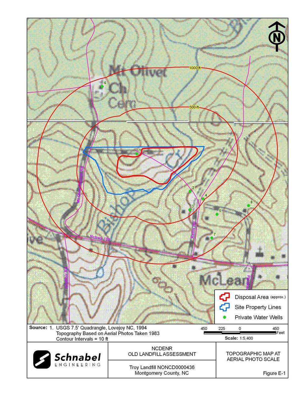
4 AREAS OF NOTE 1) A residence is located to the north of the Disposal Area on the Site. A working well is located to the east of the residence, but the water is not used for drinking. 2) There is evidence of human activity on the Disposal Area as indicated by the locked gate, shooting range, and a large garbage bin. 3) Residences, Mt. Olivet Methodist Church and Cemetery, and Sanders Packaging Company are located within 1,000 feet of the Disposal Area. 4) Ms. Jo Haywood, Senior Utilities Representative for the Montgomery County Water Department, stated that a county water line is available for residents along NC Highway 109, but not along Mt. Olive Church Road. She stated that a water tap is not present at Mt. Olive Church Road. 5) Bishop Creek is located along the eastern boundary of the Disposal Area. An unnamed perennial stream is located on the southern part of the Site. 6) An area of standing water was observed on the southern portion of the Disposal Area. 7) Hummocky topography consisting of piles of soil and debris from five to ten feet high were observed on the eastern and southern portions of the Disposal Area. 8) Exposed debris consisted of glass, plastic, rusted 55-gallon drums, white goods, tires, scrap metal, metal fencing and wires, oil containers, concrete, and brick. 9) Holes up to two feet deep with exposed concrete debris were observed on the eastern portion of the Disposal Area. 10) An unrecognized odor was noticed on the shooting range in the central part of the Disposal Area. 11) Gullies were observed on the eastern part of the Disposal Area. Troy Landfill NONCD
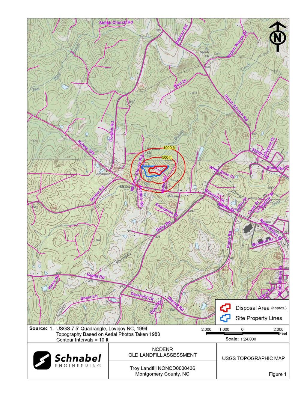
5 SITE SUMMARY 1.0 SITE CONDITIONS This section discusses the observed conditions on the Site, as defined as the property (Tax Parcel ) on which the Disposal Area is located. The Disposal Area is defined as the area observed or reported to have been used for waste placement or burial. The boundary (perimeter) of this area is the observed limit of waste material based on field observations and the inferred limit based on a review of historical aerial photographs. The site visit was conducted on February 17, Photographs illustrating site conditions are included in Appendix D. The Site is located in Montgomery County, near Troy, NC. Driving directions to the Site from the intersection of NC Highway 24/27 (Albemarle Road) and NC Highway 109 (Bilhen Street) are as follows: 1. Proceed north on NC Highway 109 (Bilhen Street) and drive approximately 0.8 mile. 2. Turn left onto NC Highway 109 (Eldorado Street) and drive west for approximately 1.3 miles. 3. Turn right onto Mt. Olive Church Road and drive north for approximately 0.2 mile. 4. The entrance to the Site is through a locked gate. The Disposal Area is to the east and south of the residence. 1.1 On-site Structures A residence is located to the north of the Disposal Area on the Site (Photo 2). According to Lt. James Kerney Jr., Montgomery County Sheriff s Department, the residence is no longer occupied and is used by the Montgomery County Law Enforcement as storage for the shooting range. This structure is located about 45 feet north from the Disposal Area. The structure is a single-family residence, on slab with concrete block construction, and asphalt roofing shingles. Troy Landfill NONCD
6 A shooting range is located on the northern part of the Disposal Area (Photo 6). It is constructed of concrete slab and metal roofing. The shooting range is approximately 60 feet wide and 85 feet long. 1.2 Current Site Usage According to Lt. Kerney Jr., the Site is used by the Montgomery County Law Enforcement as a shooting range and training facility. Observed evidence of recent human activity included the shooting range, locked fence at the Site entrance, and garbage bin. 1.3 On-Site Water Supply Wells and Intakes A working well is located approximately 40 feet east of the residence, and according to Lt. Kerney Jr., the well is not used for drinking (Photo 3). No water meters or fire hydrants were observed on the Site during the site visit. 1.4 Surface Water Features Bishop Creek is located along the eastern boundary of the Disposal Area (Photo 10). The stream was approximately 10 feet to 15 feet wide with a sandy/gravel stream bed, moderate flow to the north, and clear to cloudy water quality. Exposed debris consisting of white goods and tires were observed within the stream bed at the time of the site visit. An unnamed perennial stream is located on the southern part of the Site. An area of standing water approximately 30 feet by 40 feet was observed on the southern portion of the Disposal Area. The standing water is a result of poor drainage and the water is cloudy. Partially submerged trees were observed within the water during the site visit (Photos 17 and 18). Troy Landfill NONCD
7 1.5 Disposal Area Access to the Disposal Area is from Mt. Olive Church Road through a locked gate (Photo 1). The Disposal Area occupies 6.7 acres based on the estimated Disposal Area perimeter shown on Figures 1 through 3. The ground surface of the Disposal Area slopes generally toward the south and east. A comparison was made of the topography from the 1994 USGS 7.5 minute topographic quadrangle map (10 foot contours, based on the 1983 aerial photograph with the 2005 topographic map from NCDOT (4 foot contours). Topographic lines in undisturbed or undeveloped areas of the two maps did not correlate well so the maps could not be used to estimate the amount of fill or other topographic changes on the Site. The LiDAR Shaded Relief Map (Figure 5) shows an anomalous flat area in the western part of the Disposal Area and anomalous relief and depressions in the eastern and southern part of the Disposal Area. The reported years of operation were from the late 1940 s to the late 1970 s, so the 1994 USGS map represents the land surface after the disposal period. Differences between elevations on the maps may reflect actual elevation changes or may be apparent differences due to the different map making methods. Differences in scale and methods of mapping are not sufficient to evaluate some changes in topography. GPS coordinates were taken of the Disposal Area perimeter. The approximate Disposal Area perimeter is illustrated on the figures and on aerial photographs in Appendix E. A table of GPS coordinates for the Site entrance and the Site perimeter is presented in Table 1. The Disposal Area perimeter location is approximate and is based on visual observations made at the time of the site visit and interpretation of aerial photographs. Figures 4 and 5 show LiDAR shaded relief superimposed on the Disposal Area. Troy Landfill NONCD
8 1.6 Disposal Area Conditions The Disposal Area was covered with grass, bare ground, concrete, mounds of soil, vines, briars, and pine trees and deciduous trees approximately two to twelve inches in diameter. Exposed debris consisted of glass, plastic, rusted 55-gallon drums, white goods, tires, scrap metal, metal fencing and wires, oil containers, concrete, and brick. Gullies were observed on the eastern part of the Disposal Area. The gullies were approximately 7 feet to 10 feet across and 6 feet deep (Photo 14). The observed Disposal Area was on a single tax parcel, Parcel Number The perimeter of the Disposal Area was visually evident. Hummocky topography consisting of piles of soil and debris from five to ten feet high were observed on the eastern and southern portions of the Disposal Area (Photos 15 and 16). Holes with exposed concrete debris were observed on the eastern portion of the Disposal Area up to two feet deep. An unrecognized odor was noticed on the shooting range within the central part of the Disposal Area. Stained or discolored soils and slope failures were not observed during the site visit. 1.7 Evidence of Human Activity Evidence of recent human activity on the Site consisted of the locked gate, shooting range, and garbage bin north of the Disposal Area. Troy Landfill NONCD
9 1.8 Potential Landfill Gas Migration Pathways There were visible or evident potential gas migration pathways observed on the Disposal Area and Site. Potential gas migration pathways located on the Disposal Area and Site were: Well: Near the northern perimeter of the Disposal Area. Residence: Near the northern perimeter of the Disposal Area. Animal Burrows: Observed throughout Disposal Area. Holes: Observed on the eastern portion of the Disposal Area. 1.9 Physical Barriers Site access is provided by a gravel driveway from Mt. Olive Church Road. Site access for vehicles is blocked by a locked gate across the driveway. Bishop Creek and the perennial stream are physical barriers along the eastern and southern perimeters of the Site, respectively. Ridges approximately 10 to 20 feet high along the shooting range are steep and difficult to walk on. Thick vines and briars limit access to the eastern portion of the Disposal Area Other Pertinent Information Some history of the Site was obtained during conversations with persons familiar with the Site. The information obtained indicates that: Mr. Joe Reynolds, General Manager for Republic Services of NC, LLC, stated that he knew of seven to eight sites in the east Montgomery County area that were trench fill Disposal Areas. He stated that he was not aware of similar types of Sites on the western part of Montgomery County. Mr. Reynolds referred Schnabel staff to Mr. Billy Maness, General Manager for Allied Waste, Inc., because Mr. Maness s father was a garbage hauler in western Montgomery County during the time that the Troy Landfill was operating. Mr. Billy Maness, General Manager for Allied Waste, Inc., stated that the Site was located across Highway 109 from the Sanders Packaging Company. Troy Landfill NONCD
10 Mr. Maness stated that Montgomery County Law Enforcement owns the property and uses it for a shooting range. Mr. Gray Walls, Public Works Director for the Town of Troy, was not familiar with the history of Troy Landfill. Mr. Walls interviewed local residents about the Site and stated that it is located off of Highway 109. A shooting range, operated by the Montgomery County Law Enforcement, is on the Site. Lt. James Kerney Jr., Montgomery County Sheriff s Department, gave Schnabel staff permission to access the Site. Lt. Kerney Jr. stated that the Town of Troy owned and operated the Site, but he did not know the years of operation. Lt. Kerney Jr. stated that the house located to the north of the shooting range was owned by the Town and a local resident lived in the house while the landfill was in operation. He stated that the well to the east of the house was not used for drinking, but for watering the grass on the shooting range. Lt. Kerney Jr. was not aware of any hazardous materials dumped on the Disposal Area. He said that other officers have found household appliances exposed on the Disposal Area. Lt. Kerney Jr. stated that after the Town of Troy closed the Site, the resident living at the Site sold the property to the Montgomery County Law Enforcement. Lt. Kerney Jr. stated that the Law Enforcement and the Town placed approximately 200 truck loads of fill on top of the Disposal Area where the shooting range is now located. He said that the mounds and ridges were placed there for the shooting range. Lt. Kerney Jr. stated that the local residences are supplied by public water and that the officers bring bottled water to the Site when training at the shooting range. Notes from conversations with people familiar with the site are included in Appendix C. The information obtained from these conversations has not been verified or confirmed. Troy Landfill NONCD
11 2.0 VICINITY CONDITIONS This section describes the observed general conditions in the vicinity of the Site, as defined as an area within 1,000 feet of the perimeter of the Disposal Area. Photographs illustrating vicinity conditions are included in Appendix D. 2.1 Structures Located on Adjacent Properties Structures described in this section are located on adjacent properties that have a shared property boundary with the Site and are within 1,000 feet of this Disposal Area. Residences are located to the east of the Site on multiple tax parcels. Mount Olivet Methodist Church is located on Tax Parcel to the north of the Site. Sanders Packaging Company is located on Tax Parcel to the south of the Site. These structures are shown on Figure 2 and on aerial photographs in Appendix E. Troy Landfill NONCD
12 2.2 Water Supply Wells and Intakes Water supply wells or well houses were not observed at residences along Mt. Olive Church Road and Highway 109 within a 1,000-foot radius of the Disposal Area. Water meters were observed in the yards of several of the residences within 1,000 feet of the Site. Fire hydrants were observed within 1,000 feet of the Site on Mt. Olive Church Road. Ms. Jo Haywood, Senior Utilities Representative for the Montgomery County Water Department, stated that a county water line is available for residents along NC Highway 109, but not along Mt. Olive Church Road. She stated that a water tap is not present at Mt. Olive Church Road. Water supply wells possibly in use were observed at residences along Kellis Road within a 1,000-foot radius of the Disposal Area. Locations and descriptions of wells within 1,000 feet of the Disposal Area are tabulated below and approximate locations are shown on the figures and aerial photographs in Appendix E. Well 1 is in an apparent up-gradient direction from the Disposal Area. Wells 2 through 8 are located east of Bishop Creek and in an apparent side- to up-gradient direction from the Disposal Area. Well Number Approximate Distance from Disposal Area Perimeter (feet) 1 <500 2 <500 3 <500 4 <500 WATER SUPPLY WELLS IN VICINITY (May no longer be used for drinking water) Address Montgomery County Law Enforcement P.O. Box 297 Troy, NC Ms. Celeste Kellis 155 Kellis Road Troy, NC Mr. David Kellis 135 Kellis Road Troy, NC Mr. Bobby Stewart 315 East Main Street Troy, NC Location Basis* Observed Visually Near Residence Near Residence Near Residence Troy Landfill NONCD
13 WATER SUPPLY WELLS IN VICINITY (May no longer be used for drinking water) The Dennis Family Trust to 1, Kellis Road Near Residence Troy, NC to 1,000 Mount Olivet Methodist Church Rt. 2, Box 124 Near Residence Troy, NC to 1,000 Mr. Jesse Dennis 136 Kellis Road Near Residence Troy, NC to 1,000 Mr. David Dennis 830 Hwy 109 Troy, NC Near Residence * The private water well locations shown on figures and aerial photographs in Appendix E are relatively accurate for wells located by GPS or visual observation. If not observed, water wells are assumed to be near residences not served by public water systems and these well locations are shown in an assumed location near the residences on figures and aerial photographs. Wells are shown as of 2010 and are plotted on all aerial photographs from all years. No public water supply wells or intakes were listed on the NCDENR Public Water Supply Section s database (as of January 2010) within two miles of the Disposal Area. 2.3 Current Land Usage Property in the vicinity of the Site is primarily wooded and residential. Land usage at the time of the site visit within 1,000 feet of the Disposal Area perimeter was: North: Wooded and Mt. Olive Church and Cemetery, apparent up- to down-gradient direction from the Site. South: Wooded and perennial stream, apparent down-gradient direction to streams, then up-gradient from the Site. East: Wooded, residences, and Bishop Creek, apparent up-gradient direction from the Site. West: Wooded, apparent side- to up-gradient direction from the Site. Troy Landfill NONCD
14 2.4 Surface Water Features Bishop Creek is located along the eastern perimeter of the Disposal Area and Site. The stream is approximately 10 feet to 15 feet wide with a sandy/gravel stream bed, moderate flow to the north, and clear to cloudy water quality. Two tributaries of the Bishop Creek are located to the south of the Site within 1,000 feet. An unnamed perennial stream is located to the south of the Site. The stream is approximately 5 feet to 7 feet wide with a sandy stream bed, slow flow to the southeast, and cloudy water quality at the time of the site visit. Troy Landfill NONCD
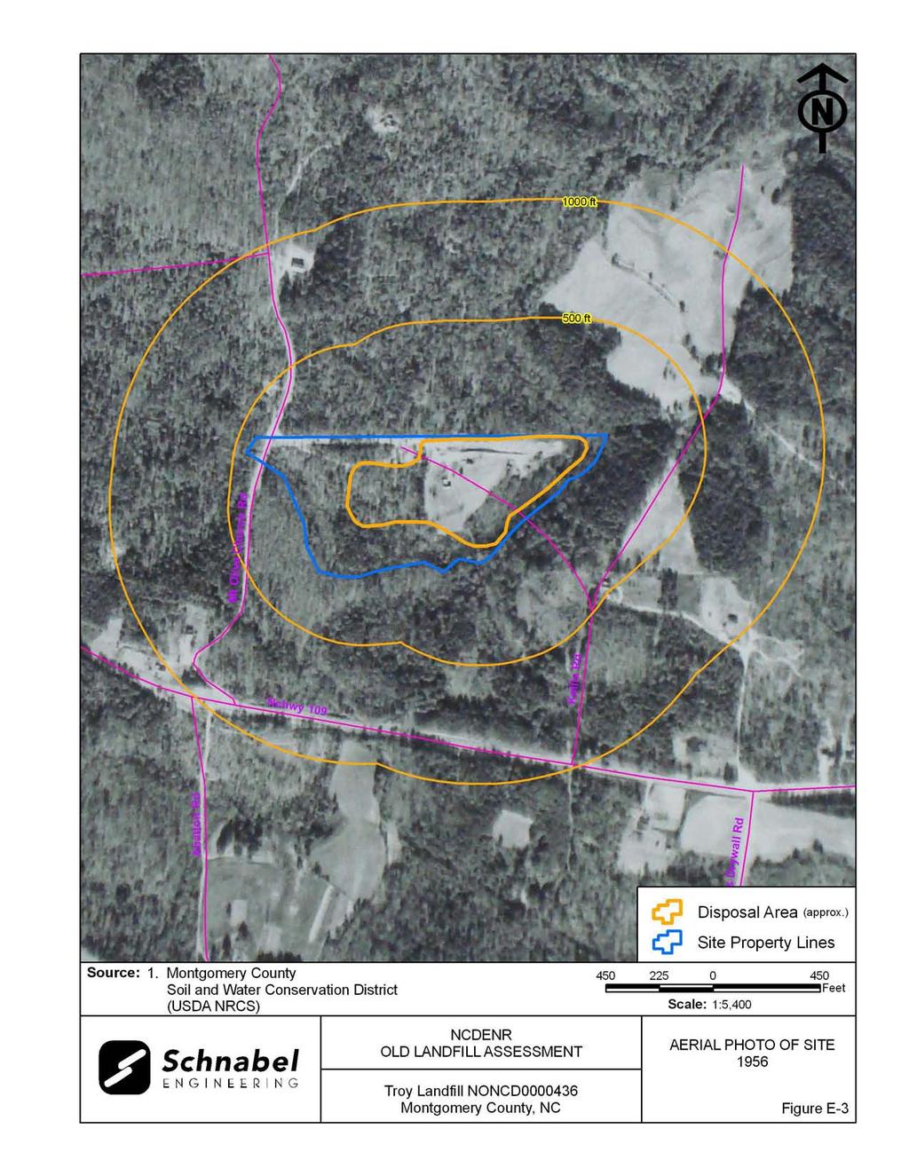
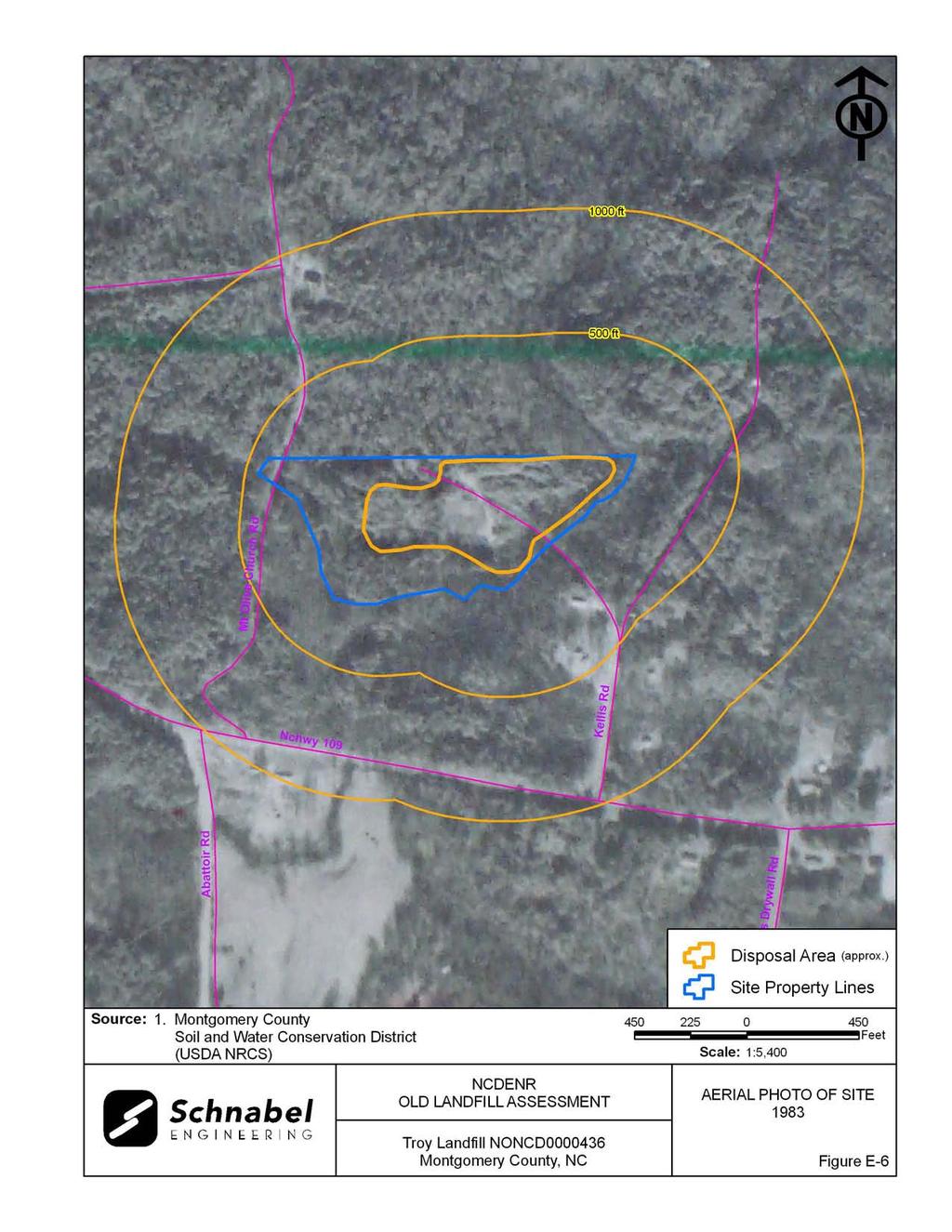
15 3.0 AERIAL PHOTOGRAPHY REVIEW Aerial photographs were reviewed for the years 1950, 1956, 1968, 1977, 1983 and The reported years of operation of the Site were from the late 1940 s to the late 1970 s. Observations of each of the photographs are included in the following table. Copies of the aerial photographs are included in Appendix E. Some aerial photographs are reproductions of original aerial photographs and have some distortion; therefore, overlaid Disposal Area Boundaries and other features may vary from their actual locations. Hand drawn lines and notations on the photographs denote soils mapping information drawn on the original photographs by the USDA NRCS. Flight Year Observations Source 1950 The east central part of the Disposal is cleared. A structure is visible on the central part of the Disposal Area. A road connects the Disposal Area to Mt. Olive Church Road to the west. The western and southern parts of the Site are wooded and undeveloped. Mt. Olivet Methodist 1 Church is visible to the north of the Site. Residences are visible to the east. NC Highway 109 is visible to the south of the Site Most of the eastern part of the Disposal Area is cleared. Roads connect the Disposal Area to Mt. Olive Church Road to the west. Three structures are visible in the central part of the Disposal Area. 1 The vicinity appears similar to the 1950 aerial photograph The eastern and southern parts of the Disposal Area are partially cleared. Disposal material is visible on the eastern boundary of the Disposal Area. A residence is visible near the northwestern boundary 1 of the Disposal Area. Residences are visible east of the Site The Disposal area is covered with light colored vegetation. The road to the central part of the Disposal Area is visible. Sanders Packaging 1 Company is visible to the south of the Site The Disposal Area is wooded. The roadway from the central part of the Disposal Area is visible The north central part of the Disposal Area is cleared. The residence and shooting range are visible. The aerial photograph shows conditions representative of those observed during the visit. 2 Sources of aerial photos: 1) USDA NRCS office in Troy, NC 2) NC ONE Map, ftp:// /outgoing/raster/local_imagery/montgomery2005 Troy Landfill NONCD
16 This report was prepared specifically for the use of NCDENR Inactive Sites Branch under the Scope of Work defined in our contract dated October 26, Use of this document for other purposes or by other parties is at the sole risk of the user. Troy Landfill NONCD
17 TABLE
18 Point TABLE 1 Tabulated GPS Coordinates State Plane Coordinates (meters) Latitude (deg, min, sec) Longitude (deg, min, sec) Northing Easting N W Site Entrance P P P P P P P P P P P P P P P P P P P P P P Notes: 1) All points P-1 through P-22 are on observed Disposal Area perimeter. 2) Data obtained during site visit using WAAS enabled Thales Mobile Mapper. 3) All points in NAD83 datum.
19 FIGURES
20

21

22

23
24
25 FIELD RECONNAISSANCE SHEET
26
27
28
29
30
31
32 TAX RECORDS
33 Page 1 of 1 2/25/2010 MONTGOMERY COUNTY LAW ENFORC TR 17-TROY MONTGOMERY COUNTY REVAL OF 1 TIME/DATE 9:35:47-11/12/09 P O BOX 297 DD 10/08/02 7/28/ W4-TONYAE TROY, NC TOWN OF TROY RESIDENTIAL RESIDENTIAL R RWNC HWY 109 TOTAL HEATED AREA 792 TOTAL AREAS BAS Y , CONC OR CINDER BLO TOTAL BASE AREA TER N BASE RATE CAN N GABLE SIZE ADJ B/R ASPHALT SHINGLES EXT WALL ADJ BAS 7 CELOTEX CEIL HEATING ADJ 1.56 A/C ADJ TILE # FLOORS ADJ 02 CONCRETE N/S WALL ADJ HT CONCRETE BLOCK COMM WALL ADJ GAS ADJ BASE RATE FORCED AIR HEATING 01 CENTRAL AIR BASE BLDG VAL #BR 2 #B 1.0 #F 1.0 N/H BLDG VAL 1235 GRADE D 000 BATHROOM ADJ COND F/A FIRE PLACE ADJ TER STKS-0 OPNG-0 BUILDING VAL SPR- HTD- A/C- GRADE ADJ %CMP- DEPRECIATION NEIGHBORHOOD EOBS BOOK PAGE MO YR IN Q PRICE FOBS ,000 BLDG APR VAL OBXF VAL ,500 PRIOR OWNER MCGUIRT, PAMELA R LAND VAL TOTAL THIS CARD FF/FT , , , , TOTAL ALL CARDS L 15,520 4 B 27,117 5 O 6 T 42,600 MKT ADJ TOTAL AC %OWNED ,092 F/U VAL OFF MT. OLIVE CHURCH RD GAS HEAT & A/C FOR JB

34 Montgomery Co., NC -- Printable Map Page 1 of 1 2/25/2010 Montgomery County, NC DISCLAIMER: The information contained on this page is NOT to be construed or used as a "legal description". Map information is believed to be accurate but accuracy is not guaranteed. Parcels Parcel No: Lot Number: Parcel Address: 0 NC HWY 109 Legal Description: TOWN OF TROY Parcel Owner: Deed Reference: Bk. 242 Pg. 593 MONTGOMERY COUNTY LAW ENFORC. Land Area: 13.34A acres P O BOX 297 Year Built: 1983 TROY, NC Building Value: $34,859 Land Value: $20,092 Other Value: $0 Total Tax Value: $55,000 Sale Year: 90 Sale Price: $25,000 Anderson & Associates, Inc.
35 RECORDS OF COMMUNICATION/SITE VISIT PERMISSION LETTER
36
37
38 RECORD OF CONVERSATION INTERVIEW SCHNABEL STAFF: Sue Mickiewicz DATE/TIME: January 25 and 28, 2010 INTERVIEW WITH: Mr. Gray Walls PHONE NO.: TITLE: Public Works Director FAX NO.: ORGANIZATION: Public Works Department, Town of Troy ADDRESS: 315 North Main Street, Troy, NC PROJECT: NC DENR Old Unlined Landfill Assessments SITE NAME AND NCDENR ID NO.: Troy Landfill, NONCD SUBJECT: Interview NOTES: January 25, 2010 Sue Mickiewicz left a message for Mr. Gray Walls, Public Works Director for the Town of Troy. January 28, 2010 Sue Mickiewicz interviewed Mr. Gary Walls about his knowledge of the Troy Landfill. Mr. Walls was not familiar with the history of Troy Landfill. Mr. Walls interviewed local residents about the Site and stated that it is located off of Highway 109 and a shooting range, operated by the Montgomery County Law Enforcement, is now on the Site. G:\2006_projects\ _(NCDENR_Old_Unlined_Landfill)\Task_23_Montgomery_Co\0436- TroyLandfill\Report\Final\RecOfConv-GrayWalls doc
39 RECORD OF CONVERSATION SITE ACCESS PERMISSION - INTERVIEW SCHNABEL STAFF: Sue Mickiewicz DATE/TIME: January 28, 2010 INTERVIEW WITH: Lt. James Kerney, Jr. PHONE NO.: February 3, 8, 10, 12, and 17, 2010 TITLE: Lieutenant, Site Contact FAX NO.: ORGANIZATION: Montgomery County Sheriff s Department ADDRESS: 111 West Main Street, Troy, NC PROJECT: NC DENR Old Unlined Landfill Assessments SITE NAME AND NCDENR ID NO.: Troy Landfill, NONCD SUBJECT: Site Access Permission - Interview NOTES: January 28, 2010 Sue Mickiewicz contacted the Montgomery County Sheriff s Department and left a message for Captain Garner in regards to the Troy Landfill. February 3, 2010 Sue Mickiewicz and Ben Bradley left a Property Owner Letter for Captain Garner at the Sheriff s Station in Troy, NC. February 8, 2010 Sue Mickiewicz called and left a message for Captain Garner at the Montgomery County Sheriff s Department. February 10, 2010 Sue Mickiewicz called and left a message for Lieutenant James Kerney Jr. of the Montgomery County Sheriff s Department after failed attempts to reach Captain Garner. The receptionist at the Montgomery County Sheriff s Department stated that no one specifically operates or works at the shooting range. February 12, 2010 Sue Mickiewicz left a message for Lt. James Kerney Jr. stating that Schnabel staff will be at the Site on February 17, 2010 at 1:00pm. February 17, 2010 Sue Mickiewicz and Ben Bradley met Lt. James Kerney Jr. at the Site. Lt. Kerney Jr. gave Schnabel staff permission to access the Site. Lt. Kerney Jr. stated that the Town of Troy owned and operated the Site, but he did not know the years of operation. G:\2006_projects\ _(NCDENR_Old_Unlined_Landfill)\Task_23_Montgomery_Co\0436- TroyLandfill\Report\Final\RecOfConv-MontLawEnforcement doc
40 Lt. Kerney Jr. said that the house located to the north of the shooting range was owned by the town and a local residence lived in that house while the landfill was in operation. He said that the well to the east of the house is still working. The well is not used for drinking, but for watering the grass on the shooting range. The water was tested and contained high concentrations of iron. Lt. Kerney Jr. was not aware of any hazardous materials dumped on the Disposal Area. He said that other officers have found household appliances exposed on the Disposal Area. Lt. Kerney Jr. stated that after the Town of Troy closed the Site, the residence living at the Site sold the property to the Montgomery County Law Enforcement. Lt. Kerney Jr. stated that the Law Enforcement and the Town placed approximately 200 truck loads of fill on top of the Disposal Area where the shooting range is now located. He said that the mounds and ridges were placed there for the shooting range. Lt. Kerney Jr. stated that the local residences are supplied by public water and that the officers bring bottled water to the Site when training at the shooting range. G:\2006_projects\ _(NCDENR_Old_Unlined_Landfill)\Task_23_Montgomery_Co\0436- TroyLandfill\Report\Final\RecOfConv-MontLawEnforcement doc
41 RECORD OF CONVERSATION INTERVIEW SCHNABEL STAFF: Sue Mickiewicz DATE/TIME: January 28, 2010 INTERVIEW WITH: Mr. Joe Reynolds PHONE NO.: TITLE: General Manager FAX NO.: ORGANIZATION: Republic Services of NC, LLC ADDRESS: 2477 US Highway 301 North, Dunn NC PROJECT: NC DENR Old Unlined Landfill Assessments SITE NAME AND NCDENR ID NO.: Troy Landfill, NONCD SUBJECT: Interview NOTES: On January 28, 2010, Sue Mickiewicz interviewed Mr. Joe Reynolds, General Manager for Republic Services of NC, LLC, about his knowledge of the Troy Landfill. Mr. Reynolds stated that he knew of seven to eight sites in the east Montgomery County area that were trench fill Disposal Areas. He stated that he was not aware of similar types of Sites on the western part of Montgomery County. Mr. Reynolds referred Schnabel staff to Mr. Billy Maness, General Manager for Allied Waste, Inc., because Mr. Maness s father used to be a garbage hauler in western Montgomery County during the time that the Troy Landfill was operating. G:\2006_projects\ _(NCDENR_Old_Unlined_Landfill)\Task_23_Montgomery_Co\0436- TroyLandfill\Report\Final\RecOfConv-JoeReynolds doc
42 RECORD OF CONVERSATION INTERVIEW SCHNABEL STAFF: Sue Mickiewicz DATE/TIME: January 28, 2010 INTERVIEW WITH: Mr. Billy Maness PHONE NO.: ; TITLE: General Manager FAX NO.: ORGANIZATION: Allied Waste, Inc. (Waste Management) ADDRESS: 1137 Albemarle Road, Troy NC PROJECT: NC DENR Old Unlined Landfill Assessments SITE NAME AND NCDENR ID NO.: Troy Landfill, NONCD SUBJECT: Interview NOTES: On January 28, 2010, Sue Mickiewicz interviewed Mr. Billy Maness, General Manager for Allied Waste, Inc., about his knowledge of the Troy Landfill. Mr. Maness was aware of the location of the Troy Landfill. He stated that it was located on Highway 109 across the highway from the Sanders Packaging Company. Mr. Maness stated that the Montgomery County Law Enforcement owns the property and uses it for a shooting range. G:\2006_projects\ _(NCDENR_Old_Unlined_Landfill)\Task_23_Montgomery_Co\0436- TroyLandfill\Report\Final\RecOfConv-BillyManess doc
43 RECORD OF CONVERSATION INTERVIEW SCHNABEL STAFF: Sue Mickiewicz DATE/TIME: February 26, 2010 INTERVIEW WITH: Ms. Jo Haywood PHONE NO.: TITLE: Senior Utilities Representative FAX NO.: ORGANIZATION: Montgomery County Water Department ADDRESS: 102 East Spring Street, Troy, NC PROJECT: NC DENR Old Unlined Landfill Assessments SITE NAME AND NCDENR ID NO.: Troy Landfill, NONCD SUBJECT: Interview NOTES: On February 26, 2010, Sue Mickiewicz interviewed Ms. Jo Haywood, Senior Utilities Representative for the Montgomery County Water Department, concerning county water access to the nearby residents of Mt. Olive Church Road and NC Highway 109. Ms. Haywood stated that a county water line is available for residents along NC Highway 109, but not along Mt. Olive Church Road. She stated that a water tap is not present at Mt. Olive Church Road. G:\2006_projects\ _(NCDENR_Old_Unlined_Landfill)\Task_23_Montgomery_Co\0436- TroyLandfill\Report\Final\RecOfConv-JoHaywood doc
44 SITE PHOTOGRAPHS


45 PHOTOGRAPH No.: 1 Photo Taken: LOCATION: Site entrance off of Mt. Olive Church Road. COMMENTS: Photo taken facing toward the east. Locked gate across gravel driveway which leads to Disposal Area. PHOTOGRAPH No.: 2 Photo Taken: LOCATION: Northern portion of Site. COMMENTS: Residence located to the north of the Disposal Area. Troy Landfill, NONCD


46 PHOTOGRAPH No.: 3 Photo Taken: LOCATION: Northern portion of Site. COMMENTS: Well east of residence. PHOTOGRAPH No.: 4 Photo Taken: LOCATION: Northern portion of Site. COMMENTS: Garbage disposal bin. Troy Landfill, NONCD


47 PHOTOGRAPH No.: 5 Photo Taken: LOCATION: Disposal Area entrance, east of the residence. COMMENTS: Photo taken toward the east. Eastern part of shooting range. PHOTOGRAPH No.: 6 Photo Taken: LOCATION: Northern portion of Disposal Area. COMMENTS: Shooting range approximately 60 feet wide and 85 feet long. Troy Landfill, NONCD


48 PHOTOGRAPH No.: 7 Photo Taken: LOCATION: Eastern portion of Disposal Area. COMMENTS: Thick vines and briars. PHOTOGRAPH No.: 8 Photo Taken: LOCATION: Eastern portion of Disposal Area. COMMENTS: Hole approximately two feet deep with exposed concrete debris. Troy Landfill, NONCD


49 PHOTOGRAPH No.: 9 Photo Taken: LOCATION: Eastern boundary of Disposal Area next to Bishop Creek. COMMENTS: Rusted 55-gallon drum and glass debris adjacent to Bishop Creek. PHOTOGRAPH No.: 10 Photo Taken: LOCATION: Eastern perimeter of Site. COMMENTS: Bishop Creek with a sandy/ gravel stream bed, moderately flowing to the north, and approximately 10 feet across. Troy Landfill, NONCD


50 PHOTOGRAPH No.: 11 Photo Taken: LOCATION: Eastern portion of Disposal Area. COMMENTS: White goods, scrap metal, and tires. PHOTOGRAPH No.: 12 Photo Taken: LOCATION: Eastern portion of Disposal Area. COMMENTS: Oil container. Troy Landfill, NONCD


51 PHOTOGRAPH No.: 13 Photo Taken: LOCATION: Eastern portion of Disposal Area. COMMENTS: Hummocky topography with exposed debris consisting of rusted 55-gallon drums, scrap metal, and metal fencing and wires. PHOTOGRAPH No.: 14 Photo Taken: LOCATION: Eastern portion of Disposal Area. COMMENTS: Gully approximately 10 feet across and 6 feet deep. Thick vines and briars. Troy Landfill, NONCD

52 PHOTOGRAPH No.: 15 Photo Taken: LOCATION: Southern portion of Disposal Area. COMMENTS: Photo taken facing toward the west. Hummocky topography. Approximately 10 feet high soil and debris piles. PHOTOGRAPH No.: 16 Photo Taken: LOCATION: Southwestern portion of Disposal Area. COMMENTS: Photo taken facing toward the west. Hummocky topography approximately 5 feet high with soil, leaves, and metal debris. Troy Landfill, NONCD

53 PHOTOGRAPH No.: 17 Photo Taken: LOCATION: Southwestern portion of Disposal Area. COMMENTS: Photo taken facing toward the west. Rusted 55-gallon drum next to standing water. PHOTOGRAPH No.: 18 Photo Taken: LOCATION: Southwestern portion of Disposal Area. COMMENTS: Area of standing water approximately 30 feet by 40 feet with submerged trees. Water was cloudy at the time of the site visit. Troy Landfill, NONCD
54 AERIAL PHOTOGRAPHS
55
56
57
58
59
60
61
SUBJECT: State Contract No.: N06009S; Schnabel Project No.: NONCD , Stanfield Dump, Letter Report
 11-A Oak Branch Drive Greensboro, NC 27407 December 4, 2009 Phone: (336) 274-9456 Fax: (336-274-9486 www.schnabel-eng.com Mr. Bruce Lefler NCDENR, Division of Waste Management 1646 Mail Service Center
SWAN CREEK VILLAGE HOMEOWNERS ASSOCIATION. P.O. Box Bountiful, UT
 RV PARK REQUIREMENTS SWAN CREEK VILLAGE HOMEOWNERS ASSOCIATION P.O. Box 1188 Bountiful, UT 84011-118 The following RV Park requirements were voted on and approved by the Swan Creek Village HOA Board of
Table 1: Iron Mountain Communication Site. Latitude 1 Longitude 1 Elev 2 Address T/R/S 3 APN 4 USGS Quadrangle
 County of Riverside Public Safety Enterprise Communication Project Appendix A: Candidate Site Descriptions Overview The site is located in San Bernardino County near several communication towers in the
FOR SALE $895,000. ±10,836 SQFT Flex Warehouse & Office Space in South Asheville. Prime Location in South Asheville Corridor!
 $895,000 Prime Location in South Asheville Corridor! ±10,836 SQFT Flex Warehouse & Office Space in South Asheville SEE INSIDE FOR MORE INFORMATION! 1276 Hendersonville Road Sisbro Properties, LLC (the
DRAFT. Dorabelle Campground Rehabilitation
 DRAFT Dorabelle Campground Rehabilitation September 2012 1.1 REGIONAL SETTING AND PROJECT LOCATION The Dorabelle Campground is located on the western shore of Shaver Lake in Fresno County, California (Section
Table 1: Santiago Peak Communication Site. Latitude 1 Longitude 1 Elev 2 Address T/R/S 3 APN 4 USGS Quadrangle
 County of Riverside Public Safety Enterprise Communication Project Appendix A: Candidate Site Descriptions Overview The site is located in the Cleveland National Forest (CNF) at an existing communication
Table 1: Margarita (SDSU) Communication Site. Latitude 1 Longitude 1 Elev 2 Address T/R/S 3 APN 4 USGS Quadrangle
 Communication Site. Latitude 1 Longitude 1 Elev 2 Address T/R/S 3 APN 4 USGS Quadrangle") County of Riverside Public Safety Enterprise Communication Project Appendix A: Candidate Site Descriptions Margarita (SDSU) Communication Site Margarita (SDSU) Communication Site Overview The site is located
County of Riverside Public Safety Enterprise Communication Project Appendix A: Candidate Site Descriptions Margarita (SDSU) Communication Site Margarita (SDSU) Communication Site Overview The site is located
Access to the site is obtainable from the paved driveway leading to the MWD facility.
 County of Riverside Public Safety Enterprise Communication Project Appendix A: Candidate Site Descriptions Overview The site is located adjacent to a Metropolitan Water District (MWD) facility on El Sobrante
Triangle Land Conservancy Conservation Area Monitoring Report Carolina North
 Triangle Land Conservancy Conservation Area Monitoring Report Carolina North Property Name: Bolin Creek East Conservation Area Date of visit: March 16, 2017 County: Orange Property Type: Restrictive Covenants
Triangle Land Conservancy Conservation Area Monitoring Report Carolina North
 Triangle Land Conservancy Conservation Area Monitoring Report Carolina North Property Name: Crow Branch Conservation Area Date of visit: March 16, 2016 County: Orange Property Type: Restrictive Covenants
Triangle Land Conservancy Conservation Area Monitoring Report Carolina North
 Triangle Land Conservancy Conservation Area Monitoring Report Carolina North Property Name: Bolin Creek East Conservation Area Date of visit: 4/8/2015 County: Orange Property Type: Restrictive Covenants
Triangle Land Conservancy Conservation Area Monitoring Report Carolina North
 Triangle Land Conservancy Conservation Area Monitoring Report Carolina North Property Name: Bolin Creek West Conservation Area Date of visit: March 16, 2017 County: Orange Property Type: Restrictive Covenants
Preliminary Site Evaluation
 Preliminary Site Evaluation 100 Acre Site, US 72 Piperton, Tennessee Power Distributor: Chickasaw Electric Cooperative August 2010 SITE DATA SHEET PIPERTON US 72 SITE (100 ACRES): LOCATION & GENERAL DESCRIPTION
Table 1: Rancho Carrillo Communication Site. Latitude 1 Longitude 1 Elev 2 Address T/R/S 3 APN 4 USGS Quadrangle
 County of Riverside Public Safety Enterprise Communication Project Appendix A: Candidate Site Descriptions Overview The site is located in the Cleveland National Forest (CNF) atop a low ridge adjacent
Triangle Land Conservancy Conservation Area Monitoring Report Carolina North
 Triangle Land Conservancy Conservation Area Monitoring Report Carolina North Property Name: Crow Branch Conservation Area Date of visit: 4/8/2015 County: Orange Property Type: Restrictive Covenants Local
Lake Wissota Access Locations within the LaFayette Township. By Chad Martin
 Lake Wissota Access Locations within the LaFayette Township By Chad Martin Anson/ Wissota Access Point # 1 Road: 195 th St. Associated Fire Numbers: 13294 Defining Characteristics: Forested from road
Table 1: Avocado Flats Communication Site. Latitude 1 Longitude 1 Elev 2 Address T/R/S 3 APN 4 USGS Quadrangle
 County of Riverside Public Safety Enterprise Communication Project Appendix A: Candidate Site Descriptions Overview The candidate area is located in Northern San Diego County, 0.65 mile south of the border
ALPINE PIPELINE RIVER CROSSINGS 2009 MONITORING REPORT
 ALPINE PIPELINE RIVER CROSSINGS 2009 MONITORING REPORT Submitted to ConocoPhillips Alaska, Inc. Submitted by Michael Baker, Jr., Inc. 1400 West Benson Blvd., Suite 200 Anchorage, Alaska 99503 TABLE OF
FIGURES. Former Hoppy s Paint & Body and Knat s Barber Shop City of Plant City. CSI Job No C
 FIGURES Former Hoppy s Paint & Body and Knat s Barber Shop City of Plant City CSI Job No. 9680.33 C INFERRED EXTENT OF ARSENIC IMPACTED SOIL C.A. No. 262 Additional Soil Assessment Activities 607, 609,
DD FORM 3009, FEB 2016 REPLACES DA FORM 1247, WHICH IS OBSOLETE. Page 1 of 6 Pages Adobe Professional X
 ROUTE CLASSIFICATION For use of this form, see ATP 3-34.81/MCWP 3-17.4; the proponent agency is TRADOC. SECTION I 1. SERIAL NUMBER 2. TO 3. FOR INFORMATION 4. DATE/TIME GROUP 5. NUMBER OF SHEETS OR ENCLOSURES
Table 1: Paradise Communication Site. Latitude 1 Longitude 1 Elev 2 Address T/R/S 3 APN 4 USGS Quadrangle
 County of Riverside Public Safety Enterprise Communication Project Appendix A: Candidate Site Descriptions Overview The site is located atop a west-facing ridge overlooking the City of Norco, approximately
RAY YENKANA Willowbrook Cr, Dawson Creek BC Canada $2,847,000
 1716 Willowbrook Cr, Dawson Creek BC Canada For SALE $2,847,000 This is a rare find, 32 townhomes in Dawson Creek, BC. Excellent investment in a single title multi family complex. Vendor has upgraded this
FOR SALE $659, Unit Medical/Office. Building Two story medical / office building on ±2.118 Acres in Boiling Springs, NC.
 4-Unit Medical/Office Bank Owned Building Two story medical / office building on ±2.118 Acres in Boiling Springs, NC BANK-OWNED & PRICED TO SELL $659,000 SEE INSIDE FOR MORE INFORMATION! 327 West College
The site is located on federal land managed by the USFS, and is subject to the San Bernardino National Forest Management Plan (SBNFMP).
.") County of Riverside Public Safety Enterprise Communication Project Appendix A: Candidate Site Descriptions Overview The site is located near an existing County communication tower and USFS lookout tower
County of Riverside Public Safety Enterprise Communication Project Appendix A: Candidate Site Descriptions Overview The site is located near an existing County communication tower and USFS lookout tower
White Oak Creek. Recreational Use Attainability Analysis Summary of Findings. Texas Institute for Applied Environmental Research Stephenville, Texas
 White Oak Creek Recreational Use Attainability Analysis Summary of Findings Texas Institute for Applied Environmental Research Stephenville, Texas August 8, 2016 Sulphur Springs, Texas August 9, 2016 Mount
Section 61 Recreational Vehicle Park / Campground (Bylaw No. 2012/10)
") Part 7 General Regulations Section 61 Recreational Vehicle Park / Campground (Bylaw No. 2012/10) 61.1 A comprehensive site plan shall be provided to the satisfaction of the Development Authority that shows
Part 7 General Regulations Section 61 Recreational Vehicle Park / Campground (Bylaw No. 2012/10) 61.1 A comprehensive site plan shall be provided to the satisfaction of the Development Authority that shows
Hydraulic Report. Trail 5 Snowmobile Trail Over Mulligan Creek. Prepared By: COLEMAN ENGINEERING COMPANY Karisa V. Falls, P.E.
 Prepared for: Prepared by: Marquette County Road Commission Coleman Engineering Company Marquette, Michigan Iron Mountain, MI December 2011 Hydraulic Report Trail 5 Snowmobile Trail Over Mulligan Creek
Citrus Heights Creek Corridor Trail Project. Trail Advisory Group Meeting #3 July 8, 2013
 Citrus Heights Creek Corridor Trail Project Trail Advisory Group Meeting #3 July 8, 2013 Agenda Introductions Recap: Community Workshop, Survey Findings, and TAG Field Trip Community Concern Discussion:
1803 West Hwy 160 Monte Vista, CO (719) TTY (719)
 TTY (719)") USDA Forest Service Rio Grande National Forest http://www.fs.fed.us/r2/riogrande 1803 West Hwy 160 Monte Vista, CO 81144 (719)852-5941 TTY (719)852-6271 USDI Bureau of Land Management San Luis Valley Center
USDA Forest Service Rio Grande National Forest http://www.fs.fed.us/r2/riogrande 1803 West Hwy 160 Monte Vista, CO 81144 (719)852-5941 TTY (719)852-6271 USDI Bureau of Land Management San Luis Valley Center
Table 1: Black Eagle Communication Site. Latitude 1 Longitude 1 Elev 2 Address T/R/S 3 APN 4 USGS Quadrangle
 County of Riverside Public Safety Enterprise Communication Project Appendix A: Candidate Site Descriptions Overview The site is located on a previously graded and benched plateau within the Black Eagle
Trail Assessment Report
 Trail Assessment Report Trail Options for the Bear Creek Canyon located in Pikes Peak Ranger District, Pike National Forest and on Colorado Springs Utility Lands Due to the presence of a unique species
FACT SHEET HUNTERS POINT SHIPYARD Parcel E-2 PCB Hot Spot Time-Critical Removal Action: 2010
 FACT SHEET HUNTERS POINT SHIPYARD Parcel E-2 PCB Hot Spot Time-Critical Removal Action: 2010 Shoreline Hot Spot Area Central Portion - View North October 2009 This fact sheet provides information about
APPENDIX E LYONS PARK ESTATES DETAILED COMMUNITY ASSESSMENT RESULTS
 # Houses: 65 APPENDIX E LYONS PARK ESTATES DETAILED COMMUNITY ASSESSMENT RESULTS Overall Risk Assessment: High Description: Lyons Park Estates is located on the foothills south of the town of Lyons on
Introduction to Topographic Maps
 Introduction to Topographic Maps DIRECTIONS: Read all of the following content. READ EVERYTHING!! At the end of the packet, you will find two topographic maps. Your task is to indentify each of the elevations
David Johnson. Tom, Attached please find the final scoping letter and figures for your review. David
 David Johnson From: Sent: To: Cc: Subject: Attachments: David Johnson Tuesday, April 12, 2011 4:33 PM Thomas Malecek Dave Dyer; Jason Marks (jmarks@segroup.com) VWC Scoping Letter
Table 1: Margarita (MWD) Communication Site. Latitude 1 Longitude 1 Elev 2 Address T/R/S 3 APN 4 USGS Quadrangle
 Communication Site. Latitude 1 Longitude 1 Elev 2 Address T/R/S 3 APN 4 USGS Quadrangle") County of Riverside Public Safety Enterprise Communication Project Appendix A: Candidate Site Descriptions Margarita (MWD) Communication Site Margarita (MWD) Communication Site Overview The site is located
County of Riverside Public Safety Enterprise Communication Project Appendix A: Candidate Site Descriptions Margarita (MWD) Communication Site Margarita (MWD) Communication Site Overview The site is located
ACADIA PLANTATION RECORDS (Mss 4906) Appendix E Oversized materials from Series V. Maps, Plats, and Photographs Location: Room B6-OS:A
 Appendix E Oversized materials from Series V. Maps, Plats, and Photographs Location: Room B6-OS:A") ACADIA PLANTATION RECORDS (Mss 4906) Appendix E Oversized materials from Series V. Maps, Plats, and Photographs Location: Room B6-OS:A Folder 20 Evergreen Plantation Survey Plat 12/27/1937 Lafourche Parish
ACADIA PLANTATION RECORDS (Mss 4906) Appendix E Oversized materials from Series V. Maps, Plats, and Photographs Location: Room B6-OS:A Folder 20 Evergreen Plantation Survey Plat 12/27/1937 Lafourche Parish
Welcome to the Pacific Spas family!
 Welcome to the Pacific Spas family! Your Pacific Spa has been engineered and built to the highest standards. Enjoy it regularly and experience the serenity and satisfaction that you ve wanted. The information
Group similar facilities together separate dissimilar facilities.
 Park design Principle #1 Group similar facilities together separate dissimilar facilities. Why do we do this? Safety Differences in admission fees Differences in seasonal use Reduce user conflicts Principle
PLAINFIELD BOARD OF ZONING APPEALS October 15, :00 P.M.
 CALL TO ORDER PLAINFIELD BOARD OF ZONING APPEALS October 15, 2012 7:00 P.M. Mr. Monnett: I will now call to order the Plainfield Board of Zoning Appeals meeting for October 15, 2012. ROLL CALL/DETERMINE
National Forests and Grasslands in Texas
 United States Department of Agriculture Forest Service National Forests and Grasslands in Texas Sam Houston NF 394 FM 1375 West New Waverly, Texas 77358 Phone 936-344-6205 Dear Friends, File Code: 1950
HWY 7 COMMERCIAL PROPERTY 1135 W. Highway 7, Hutchinson, MN 55350
 OFFERING SUMMARY SALE PRICE: $825,000 LOT SIZE: 2.03 Acres YEAR BUILT: 2006 BUILDING SIZE: 11, 640 PROPERTY OVERVIEW Commercial Office, Warehouse Building with superior highway visibility and easy access
Rule Governing the Designation and Establishment of All-Terrain Vehicle Use Trails on State Land
 Rule Governing the Designation and Establishment of All-Terrain Vehicle Use Trails on State Land 1.0 Authority 1.1 This rule is promulgated pursuant to 23 V.S.A. 3506. Section 3506 (b)(4) states that an
PCBS DELINEATION WORK PLAN
 PCBS DELINEATION WORK PLAN BLUE ISLAND NORTHEAST MIXED-USE COMMERCIAL PARK (FORMER BLUE ISLAND LANDFILL) BLUE ISLAND, COOK COUNTY, ILLINOIS PREPARED FOR: CITY OF BLUE ISLAND 13051 SOUTH GREENWOOD AVENUE
2.0 Physical Characteristics
 _ 2.0 Physical Characteristics 2.1 Existing Land Use for the Project The site is comprised of approximately 114 acres bounded by Highway 101 to the north, the existing town of Los Alamos to the east, State
DEVELOPMENT & APPLICATION OF THE STATE COORDINATE SYSTEM
 DEVELOPMENT & APPLICATION OF THE STATE COORDINATE SYSTEM State of North Carolina North Carolina Department of Public Safety Division of Emergency Management North Carolina Geodetic Survey www.ncgs.state.nc.us/
APPENDIX D: SUSTAINABLE TRAIL DESIGN. APPENDICES Town of Chili Parks and Recreation Master Plan Update
 APPENDIX D: SUSTAINABLE TRAIL DESIGN APPENDICES Town of Chili Parks and Recreation Master Plan Update Sustainable Trail Construction Sustainable trails are defined by the US Forest Service as trails having
CARVER S FALLS. Cumberland County s Natural Beauty. What s Included In This Information Packette
 Cumberland County s Natural Beauty What s Included In This Information Packette History of the Falls Boy Scouts have acquired Right of Use Guidelines for Usage Application Check-out Report HISTORY AND
FOR SALE $299,000 HALF CITY BLOCK IN WEST ASHEVILLE! ± 0.52 Acres Walk to River Arts District SEE INSIDE FOR MORE INFORMATION!
 $299,000 HALF CITY BLOCK IN WEST ASHEVILLE! ± 0.52 Acres Walk to River Arts District SEE INSIDE FOR MORE INFORMATION! Haywood Road Assemblage Seller through G/M Property Group, LLC as exclusive agent,
Settlement Patterns West of Ma ax Na, Belize
 SETTLEMENT PATTERNS WEST OF MA AX NA, BELIZE 1 Settlement Patterns West of Ma ax Na, Belize Minda J. Hernke Faculty Sponsor: Kathryn Reese-Taylor, Department of Sociology/Archaeology ABSTRACT The focus
CITY OF BRIDGEPORT - GEODETIC CONTROL MONUMENTATION ESTABLISHED SEPTEMBER 2008
 1 - GEODETIC CONTROL MONUMENTATION ESTABLISHED SEPTEMBER 2008 In September 2008, Baird, Hampton & Brown established positions for 8 geodetic control monuments throughout the City of Bridgeport, Texas.
Camp Jack Wright PERMANENT ORIENTEERING COURSE (2004)
") Camp Jack Wright PERMANENT ORIENTEERING COURSE (2004) WHAT IS ORIENTEERING? The skill which enables a person to navigate with a map. In the competitive sport, the winner is the person who finishes in the
Camp Jack Wright PERMANENT ORIENTEERING COURSE (2004) WHAT IS ORIENTEERING? The skill which enables a person to navigate with a map. In the competitive sport, the winner is the person who finishes in the
Glacial Geomorphology Exercise
 James Madison University Field Course in western Ireland Glacial Geomorphology Exercise 3-day road log (abbreviated) Striations Large kame terrace Cirque with moraines Kame delta Striations Eskers Raised
Photo Album Intact/Slightly Altered. Eligible, see Statement of Significance. Roadside Development on Minnesota Trunk Highways,
 Historic Name CS # 5202 Other Name SHPO Inv # Location Hwy District Reference City/Township County Courtland Township Nicollet Acres 4.6 Twp Rng Sec 110N 30W Sec 22 Rest Area Class 4 USGS Quad UTM New
(Short Listing) SOUTH FORK LOG CABIN, UTICA, MONTANA
 SOUTH FORK LOG CABIN, UTICA, MONTANA") (Short Listing) SOUTH FORK LOG CABIN, UTICA, MONTANA The South Fork Log Cabin is in the heart of thousands of acres of public land of the Lewis & Clark National Forest Service. This Cabin offers unlimited
(Short Listing) SOUTH FORK LOG CABIN, UTICA, MONTANA The South Fork Log Cabin is in the heart of thousands of acres of public land of the Lewis & Clark National Forest Service. This Cabin offers unlimited
HEADQUARTERS WEST LTD. PHOENIX - TUCSON - SONOITA - COTTONWOOD - ST. JOHNS
 Offered for sale exclusively by: Walter Lane Headquarters West, Ltd. PO BOX 37018 Tucson, AZ 85740 Phone (520) 792-2652 info@headquarterswest.com www.headquarterswest.com General Area Description The Crown
Table 1: Glen Avon Communication Site. Latitude 1 Longitude 1 Elev 2 Address T/R/S 3 APN 4 USGS Quadrangle
 County of Riverside Public Safety Enterprise Communication Project Appendix A: Candidate Site Descriptions Overview The site is located on a low ridge of the western Jurupa Mountains adjacent to several
MINUTES OF THE OAK CREEK PLAN COMMISSION MEETING TUESDAY, NOVEMBER 8, 2011
 MINUTES OF THE OAK CREEK PLAN COMMISSION MEETING TUESDAY, NOVEMBER 8, 2011 Mayor Bolender called the meeting to order at 7:00 p.m. The following Commissioners were present at roll call: Commissioner Dickmann,
MORGAN CREEK GREENWAY Final Report APPENDICES
 APPENDICES MORGAN CREEK GREENWAY Appendix A Photos of Existing Conditions in Trail Corridor Photos of existing conditions Main trail corridor - February 2009 Photos of existing conditions south bank Morgan
Hwy Retaining Wall/ Sea Wall. Not Eligible, see Statement of Significance Also member of listed NR district: Mantorville Historic District
 Historic Name CS # 2007 Other Name SHPO Inv # Location E and W sides of TH 57 between 6th St and 7th St Hwy District Reference City/Township County Mantorville, City of Dodge Acres Twp Rng Sec 107N 16W
Alternative Daily Cover Evaluation
 Alternative Daily Cover Evaluation ADEQ Permit No. 0198-S1-R2 AFIN 01-00117 PREPARED FOR: EMS 1784 Highway One North Wynne, AR 72396 PREPARED BY: Fields & Associates, LLC 75 Norfork Drive Maumelle, Arkansas
THE ALBERTA GAZETTE, SEPTEMBER
 VILLAGE OF CEREAL Order No. 16915 IN THE MATTER OF THE "Municipal Government Act": File No. 241(A)3 AND IN THE MATTER OF an application by the Council of the Village of Cereal, in the Province of Alberta,
Big Sandy Ranch Mohave County, Arizona
 Big Sandy Ranch Mohave County, Arizona Photo [9] Deeded land on hillside within the River Ranch parcel Listed for sale exclusively by: Traegen Knight Headquarters West Ltd. PO BOX 1980 St. Johns, AZ 85936
*** Note: Mileages are based on resetting trip odometer to zero at each turn point AL-5 is Alabama Highway 5 CO-51 is County Road 51, etc.
 Directions to Ham(m) Family Reunion site of Lester Ham s Original Homestead Owned and hosted by Jeff & Renee Hamm Comments & corrections to Marv Hamm: MarvHamm@aol.com Ham(m) Family Reunion annually on
Attachment G STREAM IMPACTS. Ridge Road Extension Alternatives Analysis
 Attachment G STREAM IMPACTS for: Ridge Road Extension Alternatives Analysis PREPARED FOR: Pasco County Engineering Services Department PREPARED BY: NV5, INC. 6989 E. FOWLER AVENUE TAMPA, FLORIDA 33617
Tents & Membrane Structures Information Packet
 Tents & Membrane Structures Information Packet South Metro Fire Rescue Authority Community Safety Services Division Life Safety Bureau 9195 E. Mineral Ave. Centennial, Colorado 80112 Tel: (720) 989-2230
United States Department of the Interior National Park Service. Boundary Expansion Listed in National Register January 11, 2017
 NPS Form 10900-a (Rev. 8/2002) OMB No. 10240018 United States Department of the Interior National Park Service Boundary Expansion Listed in National Register January 11, 2017 National Register of Historic
phillips creek 20 ACRES OF WATERFRONT PROPERTY IN THE HEART OF MOUNT PLEASANT
 phillips creek 20 ACRES OF WATERFRONT PROPERTY IN THE HEART OF MOUNT PLEASANT Please contact agents for more information or to schedule a private showing: SETH CLARK 843 720 7501 DIRECT seth.clark@colliers.com
Staff Report Sign Design
 Staff Report Sign Design July 29, 2014 Planning & Zoning Commission Meeting Report date July 23, 2014 Project type Sign Design Legal description Section 2, Township 5, Range 82 Lots 3&4, S1/2NW1/4, SW1/4
Archaeological Evaluation Report
 Holywell House Osney Mead Oxford o a November 2007 Client: Knowles and Son Issue N o : 1 OA Job N o : 3826 Planning Ref N o : 02/01800/FUL NGR: SP 502 055 Client Name: Knowles and Son Client Ref No: Document
Municipal Yard & Bulky Waste Policies
 Municipal Yard & Bulky Waste Policies Bedminster Wood and Brush- Fourth Monday in April Please go to www.bedminster.us for complete policy Leaves- Last week in October through November 30th on regular
PARK SITE MASTER PLANS WEST PARK
 PARK SITE MASTER PLANS Queen Creek Road to the north, Ocotillo Road to the south, Sossaman Road to the west, and Hawes Road to the east. The land adjacent to West Park is either inactive agricultural land
AVIATION PLANNING AND DEVELOPMENT Oakland International Airport 530 Water Street Oakland, CA 94607
 AVIATION PLANNING AND DEVELOPMENT Oakland International Airport 530 Water Street When Do I Need to File an FAA Form 7460-1? Objects Affecting Navigable Airspace (14CFR77) June 2013 Background The Federal
Eagle Pinon Ranch. 2,963 +/- acres, Hudspeth County
 Eagle Pinon Ranch 2,963 +/- acres, Hudspeth County Eagle Piñon Ranch 2963 acres Hudspeth County, Texas Location The Eagles are part of a chain of sky island mountains that stretch from New Mexico through
Datum Issues in the Red River of the North Basin ----
 Datum Issues in the Red River of the North Basin ---- Scoping Document May 1999 Russell E. Harkness, Hydrologist United States Geological Survey Water Resources Division 2 EXECUTIVE SUMMARY Two datum issues
Chuckanut Ridge Fairhaven Highlands EIS Scoping Concerns
 Chuckanut Ridge Fairhaven Highlands EIS Scoping Concerns Coalition of Southside Neighborhoods CSN Comments for Fairhaven Highlands EIS Scope Hearing, Jan 16, 2008 1 Chuckanut Ridge Hilly Terrain: Potential
4. Bronze Age Ballybrowney, County Cork Eamonn Cotter
 4. Bronze Age Ballybrowney, County Cork Eamonn Cotter Illus. 1 Location map of the excavated features at Ballybrowney Lower (Archaeological Consultancy Services Ltd, based on the Ordnance Survey Ireland
SUTTER COUNTY. General Plan Update Technical Background Report
 SUTTER COUNTY General Plan Update Technical Background Report February 2008 SUTTER COUNTY GENERAL PLAN UPDATE TECHNICAL BACKGROUND REPORT PREPARED FOR: SUTTER COUNTY PREPARED BY: PBS&J IN PARTNERSHIP
Bat Cave Canyon Ranch 2,920 acres Jeff Davis County, Texas
 Bat Cave Canyon Ranch 2,920 acres Jeff Davis County, Texas James King, Agent Office 432.426.2024 Cell 432.386.2821 James@KingLandWater.com Bat Cave Canyon Ranch 2,920 acres Jeff Davis County, Texas James
Specification for Grip blocking using Peat Dams
 Technical Guidance Note 1 Specification for Grip blocking using Peat Dams 1. Introduction Moorland drains (grips) have been dug across much of the Yorkshire upland peatlands. Many of these grips have become
David Magney Environmental Consulting
 David Magney Environmental Consulting DELINEATION OF JURISDICTIONAL WATERS AND RIPARIAN HABITATS FOR LYONS CANYON RANCH, NEWHALL, CALIFORNIA Prepared for: UNITED STATES ARMY CORPS OF ENGINEERS and CALIFORNIA
STATE OF WASHINGTON ARCHAEOLOGICAL SITE INVENTORY FORM
 STATE OF WASHINGTON ARCHAEOLOGICAL SITE INVENTORY FORM Smithsonian Number: 45 County: Chelan Date: 6/12/2018 Human Remains? DAHP Case No.: Archaeological Sites are exempt from public disclosure per RCW
Clovis Fire Department
 Clovis Fire Department Standard # 4.1 TENTS & CANOPIES Purpose The intent of this standard is to provide the minimum requirements needed to obtain a permit to erect tents or canopies. Scope This standard
RE: Complaint Investigation at the Tankersley Food Warehouse
 July 24, 2009 Mr. Thomas Moon, Vice President of Operations Tankersley Food Service 3203 Industrial Park Road Van Buren, AR 72956 RE: Complaint Investigation at the Tankersley Food Warehouse Dear Mr. Moon:
Motion by Michel to approve the minutes as presented, second by Rynish, motion carried 5-0.
 SUAMICO BOARD OF APPEALS MINUTES 12781 VELP AVENUE Tuesday, August 29, 2017 7: 00 P. M. 1) CALL MEETING TO ORDER Board members present by roll call: Sue Last aye, Dan Schrader aye, Bart Rynish aye, Sharon
City of Redding Airports
 City of Redding Airports Benton Airpark Redding Municipal Airport DEVELOPMENT AND USE GUIDELINES FOR GENERAL AVIATION HANGARS April 7, 2009 PREFACE The City of Redding, as owner of federally obligated
KP Lasnaya 1 River
 KP 370.2 Lasnaya 1 River The Lasnaya 1 River crossing is protected by Reno mattings and a gabion wall on the north bank (Photo 1). The south bank consists of natural river gravel deposits on top of Reno
Northeast Stoney Trail In Calgary, Alberta
 aci Acoustical Consultants Inc. 5031 210 Street Edmonton, Alberta, Canada T6M 0A8 Phone: (780) 414-6373, Fax: (780) 414-6376 www.aciacoustical.com Environmental Noise Computer Modelling For Northeast Stoney
BUNKHOUSE ASSESSMENT REPORT
 FEBRUARY 2014 EXECUTIVE SUMMARY As a response to the need to provide temporary shelters for the victims of Typhoon Haiyan, the Philippine government through the DSWD and the DPWH decided to build bunkhouses.
35 Bee Tree Park Planning Zone 3
 35 Bee Tree Park Planning Zone 3 2701 Finestown Road Visit Date: August 2016 St. Louis County Parks Master Plan Page 1 35 Bee Tree Park 2701 Finestown Road St. Louis County Parks Master Plan Planning Zone
General Aviation Land Use Planning
 Our team. General Aviation Land Use Planning PURDUE ROAD SCHOOL - 2017 Presented by: Maria Muia, Ph.D., Senior Aviation Planner Woolpert, Inc. Brian Payne, Director Columbus Airport Nick Isenberg, Project
Mr. Michael Malone CPS Energy 145 Navarro Street San Antonio, Texas Project No
 January 15, 2016 Mr. Michael Malone 145 Navarro Street San Antonio, Texas 78205 Project No. 0328985 Environmental Resources Management CityCentre Four 840 West Sam Houston Pkwy N. Suite 600 Houston, Texas
Front Carport Design Standards, Requirements & Application
 Front Carport Design Standards, Requirements & Application THIS PAGE INTENTIONALLY LEFT BLANK. Carport: A structure designed or used to shelter vehicles that is open on at least two sides. Carport shall
HYDROLOGY OF GLACIAL LAKES, FORT SISSETON AREA
 PROC. S.D. ACAD. SCI., VOL. 77 (1998) 59 HYDROLOGY OF GLACIAL LAKES, FORT SISSETON AREA Perry H. Rahn Department of Geology & Geological Engineering South Dakota School of Mines and Technology Rapid City,
Whiteside Mountain Land Owned by: Location: Trails:
 Whiteside Mountain Latitude: 35 05.123 N Longitude: 083 07.933 W Elevation: 1,503m Land Owned by: US Forest Service Nantahala Ranger District 828-524-6441 Location: Jackson County, NC Turn off of US Highway
VISTA AZUL- APPROVED 20 LOT TENTATIVE MAP
 Expansive Views Entitlements for 20 Residential Lots Previously Graded Entitled for 14 Detached Lots, 6 Townhome Units DOWNTOWN SAN DIEGO ASKING PRICE: $1,395,000 - OFFERS DUE JULY 14, 2017 Monterey Heights
Temporary Campground Plan Review Application
 Procedure to obtain a Temporary Campground Permit Step #1 At least fifteen (15) days prior to the opening of the temporary campground, operators should complete the plan review application (Page #2 to
EVERknowledgeable EVERresponsive EVERhonorable EVERGREEN.
 7021 Johnson Drive Johnson County, KS 8450 & 8500 State Line Rd. Johnson County, Leawood, KS Property ID Size 48223 R1 34848 $100,000 Ryan Robertshaw allows for Group Home Smaller child care facility also
a. The historic avalanche areas, or areas in which there exists clear evidence of previous avalanches, are mapped.
 1 OBJECTIVES AND LIMITATIONS OF STUDY ;J'-o~ 1 j 1.1 BACKGROUND AND STUDY OBJECTIVES The communities of Aspendell, Habegger's, and Sage Flat are located in the eastern Sierra Nevada west of the towns of
ORDINANCE NO. JACKSON TOWNSHIP, CAMBRIA COUNTY
 ORDINANCE NO. JACKSON TOWNSHIP, CAMBRIA COUNTY AN ORDINANCE OF THE TOWNSHIP OF JACKSON AMENDING SECTIONS OF THE JACKSON TOWNSHIP ZONING ORDINANCE AS FOLLOWS: PROVIDING NEW DEFINITIONS OF CAMPGROUNDS, CAMPSITE,