White Oak Creek. Recreational Use Attainability Analysis Summary of Findings. Texas Institute for Applied Environmental Research Stephenville, Texas
|
|
|
- Peter Cook
- 5 years ago
- Views:
Transcription


1 White Oak Creek Recreational Use Attainability Analysis Summary of Findings Texas Institute for Applied Environmental Research Stephenville, Texas August 8, 2016 Sulphur Springs, Texas August 9, 2016 Mount Pleasant, Texas 1
2 Project Partners Texas State Soil and Water Conservation Board (TSSWCB) Texas Institute for Applied Environmental Research (TIAER) 2
3 TSSWCB Provide state oversight Management and coordination of project activities Project partners Texas Commission on Environmental Quality (TCEQ) Provide project funding 3
4 TIAER Project administration Develop & maintain stakeholder relations Perform RUAA survey activities GIS inventory Facilitate meetings Develop final technical reports 4
5 How did we get here? White Oak Creek is not meeting the water quality standard for primary contact recreation Due to elevated levels of E. coli Requires action to meet the standards that are set by the State of Texas and EPA. 5
6 What is the Texas 303 (d) List? Texas 303 (d) List of Impaired Water bodies Requirement of the Clean Water Act Developed by TCEQ to summarize the condition of the state s surface waters, including concerns for public health, fitness for use by aquatic species and other wildlife, and specific pollutants. 6
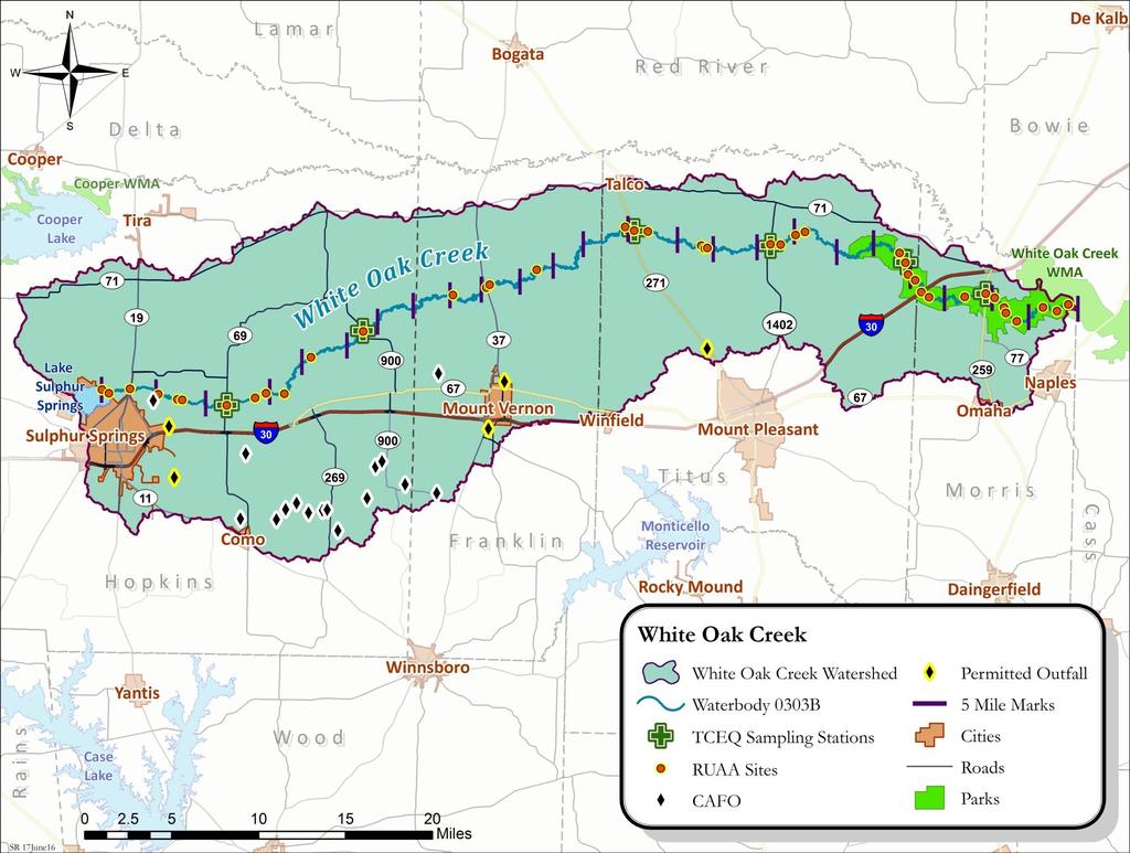
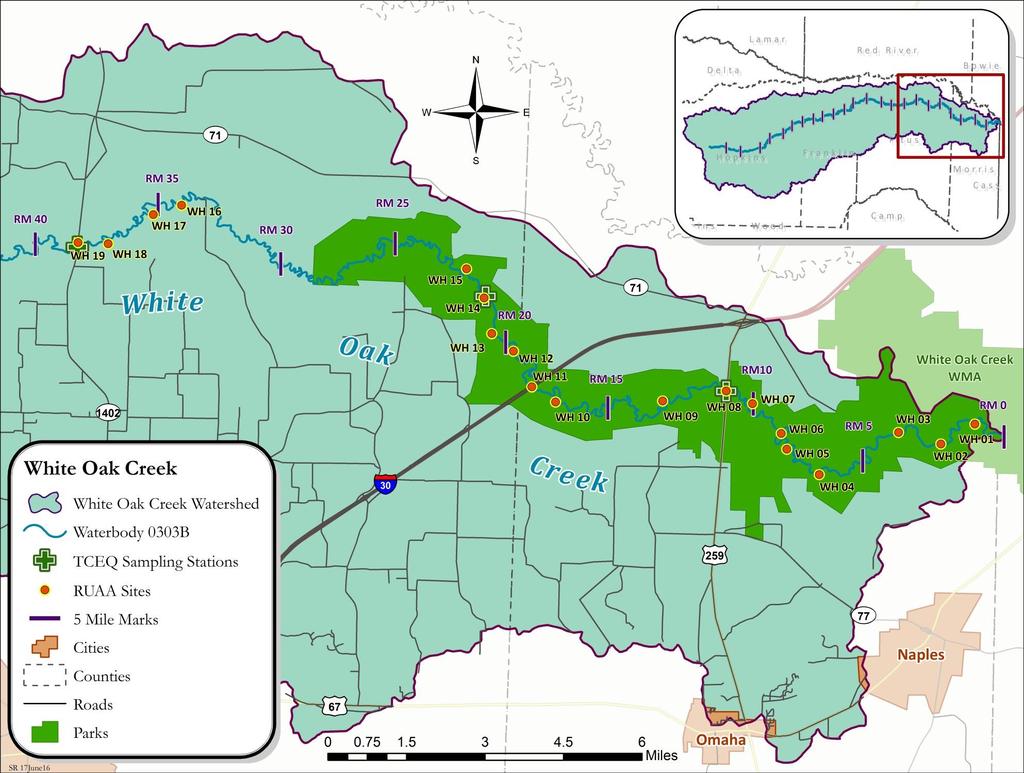
7 Impaired Stream Segments White Oak Creek (0303B) 2006 Texas Water Quality 303(d) List Bacteria Current Geometric mean = 186 cfu/ 100mL 7
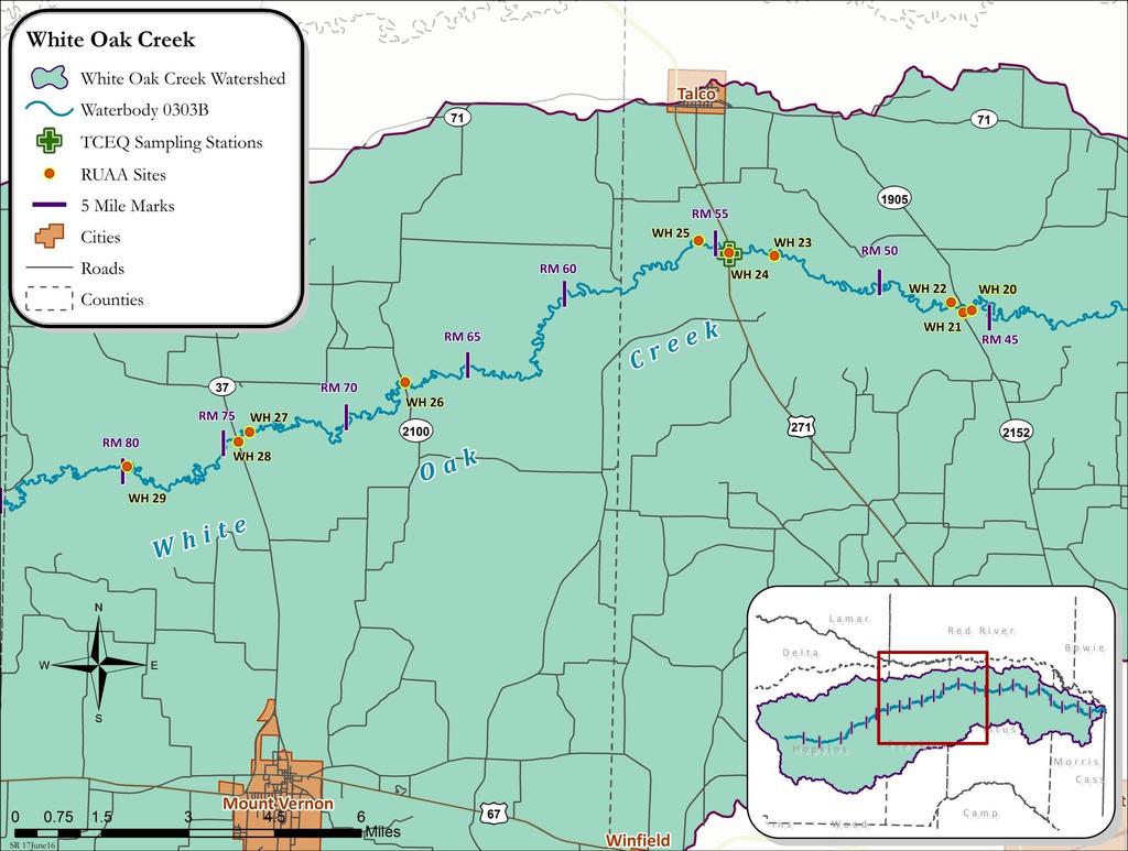
8 RUAA One method of removing the White Oak Creek from the impaired list for bacteria Assess if the recreational standard is appropriate Recreational use attainability analysis (RUAA) 8
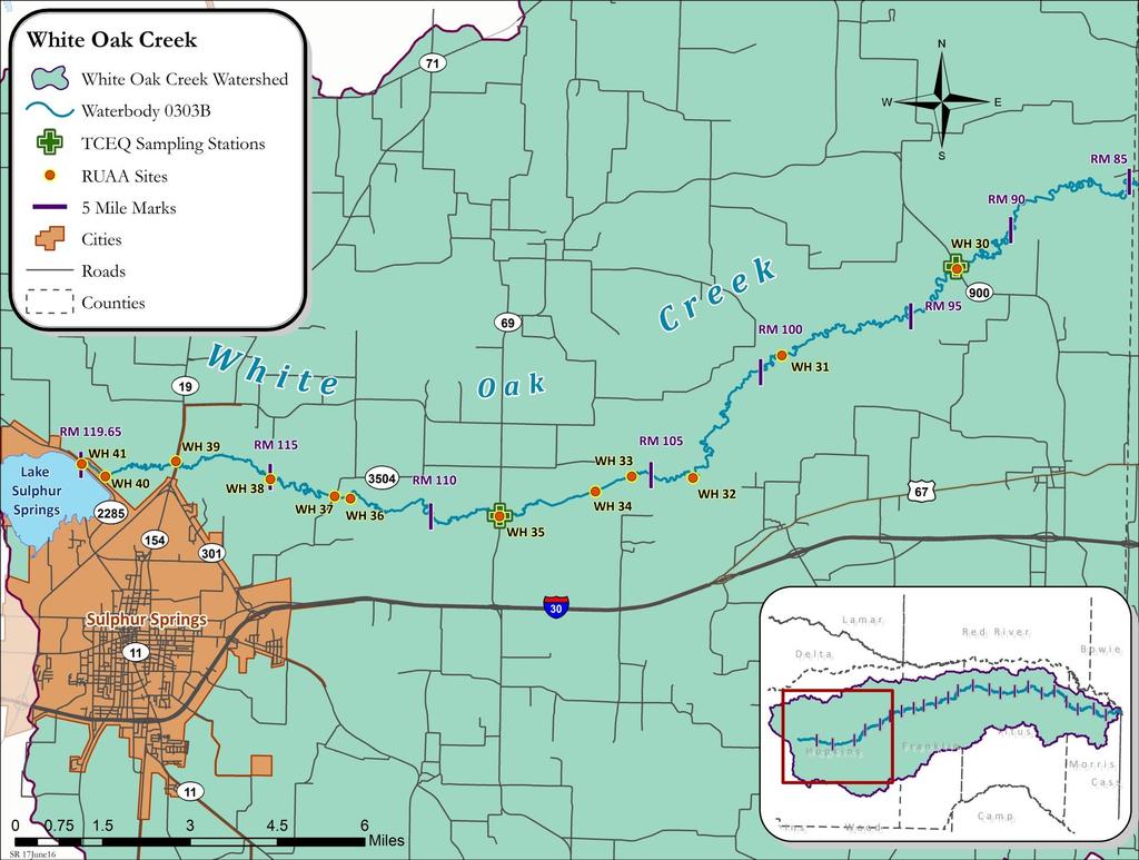
9 Purpose of RUAA To determine if primary contact recreation is the correct use or if another recreational use category may be more appropriate. 9
10 10
11 11
12 12
13 13
14 Site ID WH01 TCEQ Station Site Description Latitude Longitude White Oak Creek about 1.09 miles from the confluence with the Sulphur on White Oak Creek Wildlife Management Area Distance from Confluence (mi) [1] Distance from Previous Site (mi) Access NA Public WH02 WH03 WH04 WH05 WH06 WH07 WH WH09 WH10 White Oak Creek about 2.25 miles from the confluence with the Sulphur on White Oak Creek Wildlife Management Area White Oak Creek about 3.46 miles from the confluence with the Sulphur on White Oak Creek Wildlife Management Area White Oak Creek about 4.61 miles downstream from State Highway 259 on White Oak Creek Wildlife Management Area White Oak Creek about 3.36 miles downstream from State Highway 259 on White Oak Creek Wildlife Management Area White Oak Creek about 2.11 miles downstream from State Highway 259 on White Oak Creek Wildlife Management Area White Oak Creek about 0.84 mile downstream from State Highway 259 on White Oak Creek Wildlife Management Area White Oak Creek at State Highway 259, approximately 7.5 miles north of Omaha, Texas White Oak Creek about 1.81 miles upstream from State Highway 259 on White Oak Creek Wildlife Management Area White Oak Creek about 6 miles upstream from State Highway 259 and about 1.04 miles downstream from Interstate Highway 30 on White Oak Creek Wildlife Management Area Public Public Public Public Public Public Public Public Public 14
15 Site ID TCEQ Station Site Description Latitude Longitude Distance from Confluence (mi) [1] Distance from Previous Site (mi) Access WH11 WH12 WH13 WH WH15 WH16 White Oak Creek at Interstate Highway 30, about 21.8 miles northeast of Mt. Pleasant, Texas White Oak Creek 1.7 miles upstream from Interstate Highway 30 on White Oak Creek Wildlife Management Area White Oak Creek 2.5 miles upstream from Interstate Highway 30 on White Oak Creek Wildlife Management Area White Oak Creek at a WMA road crossing about 1.06 miles east of County Road 3445 and about 3.3 miles upstream from Interstate Highway 30 on White Oak Creek Wildlife Management Area White Oak Creek about 4 miles upstream from Interstate Highway 30 on White Oak Creek Wildlife Management Area White Oak Creek on private property, about 4.2 miles downstream from Farm Road Public Public Public Public Public Private WH17 WH18 White Oak Creek on private property, about 3.46 miles downstream from Farm road 1402 White Oak Creek on private property, about 0.72 mile downstream from Farm road Private Private WH White Oak Creek at Farm Road Public WH20 White Oak Creek about 0.33 mile downstream from County Road Public 15
16 Site ID TCEQ Station Site Description Latitude Longitude Distance from Confluence (mi) [1] Distance from Previous Site (mi) Access WH21 White Oak Creek at County Road Public WH22 WH23 White Oak Creek about 0.44 mile upstream from County Road 1905 White Oak Creek about 1.3 miles downstream from US Highway Public Public WH White Oak Creek at US Highway Public WH25 White Oak Creek about 0.76 mile upstream from US Highway Public WH26 White Oak Creek at County Road Public WH27 White Oak Creek about 0.48 mile downstream from State Highway Public WH28 White Oak Creek at State Highway Public WH29 White Oak Creek on private property about 5.15 miles upstream from State Highway Private WH White Oak Creek at Farm Road Public 16
17 Site ID TCEQ Station Site Description Latitude Longitude Distance from Confluence (mi) [1] Distance from Previous Site (mi) Access WH31 WH32 WH33 WH34 White Oak Creek on private property about 6 miles upstream from Farm Road 900 White Oak Creek on private property about 4.4 miles downstream from Farm Road 69 White Oak Creek on private property about 2.79 miles downstream from Farm Road 69 White Oak Creek on private property about 2.1 miles downstream from Farm Road Private Private Private Private WH White Oak Creek at Farm Road Public WH36 White Oak Creek on private property about 0.31 mile downstream from County Road Private WH37 White Oak Creek at County Road Public WH38 White Oak Creek on private property about 2.2 miles upstream from County Road Private WH39 White Oak Creek at State Highway Public WH40 White Oak Creek on right-of-way about 0.52 mile downstream from Farm Road Public WH41 White Oak Creek at Farm Road Public 17
18 Findings for First RUAA Survey White Oak Creek (0303B) Conducted: June 22 24, 2016 July 18 22, 2016 Summary Sufficient water for swimming, boating, and fishing in the downstream portion of White Oak Creek Thick vegetation & steep banks making it difficult to access water No direct primary contact recreation observed 18


19 White Oak Creek Photographs WH01 150m Downstream WH06 0m Upstream 19


20 White Oak Creek Photographs WH11 300m Upstream WH11 Snake 20


21 White Oak Creek Photographs WH18 0m Downstream WH20 150m Upstream 21


22 White Oak Creek Photographs WH33 Logjam WH36 300m Downstream 22


23 White Oak Creek Photographs WH38 150m Downstream WH39 0m Upstream 23
24 Next Steps Second RUAA Survey To be conducted: August 7 12, 2016 August 21 26, 2016 Interviews on-going TIAER is collecting feedback on current and past recreational uses of White Oak Creek 24
25 Next Steps Draft Technical Report To be completed by September 2017 Final Public Meeting To be held following completion of draft technical report Opportunity to review draft technical report Begins the 30 day comment period 25
26 Contact Information Leah Taylor Office Phone: Sarah Robinson Office Phone:
27 Questions? Project Website: Funding Provided through a State Nonpoint Source grant from Texas State Soil and Water Conservation Board. Leah Taylor Senior Project Director Texas Institute for Applied Environmental Research ltaylor@tiaer.tarleton.edu (254)
Mud Creek and West Mud Creek
 Mud Creek and West Mud Creek Recreational Use Attainability Analysis Summary of Findings Texas Institute for Applied Environmental Research Stephenville, Texas September 15, 2014 1 Project Partners Texas
Recreational Use Attainability Analysis Summary of Findings & Public Comment
 The Neches River Above Lake Palestine, Prairie Creek, Mud Creek, and West Mud Creek Recreational Use Attainability Analysis Summary of Findings & Public Comment Texas Institute for Applied Environmental
Meeting Agenda. Why are we here? Getting Started. Designated Uses. Water Quality Standards
 Upper Basin Total Maximum Daily Load Study and Rapidan Technical Advisory Committee Meetings July 27, Meeting Agenda Water Quality Assessments and TMDL Process Bryant Thomas, VA DEQ Overview of 16 TMDL
City of Peoria Clean Water Efforts. Governor s s Conference on the Management of the Illinois River October 4, 2007
 City of Peoria Clean Water Efforts Governor s s Conference on the Management of the Illinois River October 4, 2007 1 What do you call dinner and a movie with an unemployed guy? An unfunded man-date! 2
Finn Creek Park. Management Direction Statement Amendment
 Finn Creek Park Management Direction Statement Amendment November 2013 Management Direction Statement Amendment Approved by: Jeff Leahy Regional Director, Thompson Cariboo BC Parks November 12, 2013 Date
Tufts University Water: Systems, Science, and Society (WSSS) Program
 Program") To: From: John Foster, Elbow Cay, the Bahamas; Friends of the Environment, Marsh Harbor, the Bahamas Alex Bedig, Amanda Garfield, Shonda Gaylord, Jack Melcher, Melissa Ng, Nathan Rawding, Kendall Webster,
To: From: John Foster, Elbow Cay, the Bahamas; Friends of the Environment, Marsh Harbor, the Bahamas Alex Bedig, Amanda Garfield, Shonda Gaylord, Jack Melcher, Melissa Ng, Nathan Rawding, Kendall Webster,
RE: PATAHA CREEK FECAL COLIFORM COMPLIANCE WITH WATER QUALITY STANDARDS
 To: WRIA 35 Planning Committee Memo From: Jory Oppenheimer and Kari Vigerstol Project: WRIA 35 Level II Water Quality CC: Ben Floyd, HDR/EES; John Koreny, HDR/EES Date: March 10, 2005 Job No: 22592 RE:
Conservation of Critical Environmental Resources in Chatham Park
 Conservation of Critical Environmental Resources in Chatham Park Elaine Chiosso, Haw Riverkeeper Haw River Assembly Haw River As Seen From Chatham Park "Spreading southwestward from the banks of the Haw
DIDYMO SURVEY, LOWER FRYINGPAN RIVER, BASALT, COLORADO 2015
 DIDYMO SURVEY, LOWER FRYINGPAN RIVER, BASALT, COLORADO 2015 Second Annual Report PREPARED FOR: ROARING FORK CONSERVANCY PREPARED BY: COLORADO MOUNTAIN COLLEGE NATURAL RESOURCE MANAGEMENT PROGRAM TIMBERLINE
ASSESSMENT OF FECAL COLIFORM IN LITTLE RABBIT CREEK AND LITTLE SURVIVAL CREEK
 ASSESSMENT OF FECAL COLIFORM IN LITTLE RABBIT CREEK AND LITTLE SURVIVAL CREEK FINAL REPORT Prepared for: Alaska Department of Environmental Conservation 555 Cordova Street Anchorage, Alaska 99501 Prepared
Town of Oakfield Agricultural and Farmland Protection Plan
 SECTION III COMMUNITY OVERVIEW A. Regional Setting / Location The Town of Oakfield is located in the northwestern portion of Genesee County. Located west of New York's Finger Lakes, the Town is uniquely
North Carolina Addendum Total Maximum Daily Load (TMDL) for Impaired Segments in the Dan River Watershed to Virginia TMDLs Approved by EPA Region 3
 for Impaired Segments in the Dan River Watershed to Virginia TMDLs Approved by EPA Region 3") North Carolina Addendum Total Maximum Daily Load (TMDL) for Impaired Segments in the Dan River Watershed to Virginia TMDLs Approved by EPA Region 3 Assessment units (AU) for the Dan River, 22-(39)b and
North Carolina Addendum Total Maximum Daily Load (TMDL) for Impaired Segments in the Dan River Watershed to Virginia TMDLs Approved by EPA Region 3 Assessment units (AU) for the Dan River, 22-(39)b and
FECAL COLIFORM BACTERIA SUMMARY SHEET
 FECAL COLIFORM BACTERIA SUMMARY SHEET WATERBODY: Greybull River (Tributary to Big Horn River) (WYBH10080009) REACH DESCRIPTION: Confluence wi e Big Horn River upstream to Meeteetse, Wyoming. BACKGROUND:
Loyalsock Creek Bacterial Coliforms. Presented By: Dr. Mel Zimmerman Clean Water Institute Lycoming College Matthew Bennett Jim Rogers
 Loyalsock Creek Bacterial Coliforms Presented By: Dr. Mel Zimmerman Clean Water Institute Lycoming College Matthew Bennett Jim Rogers What is E. coli? Short for Escherichia coli (a bacteria) It is a
Southern Beltway Projects Summary
 Southern Beltway Projects Summary The Pennsylvania Turnpike Commission is proposing the construction of a 30-mile, tolled fourlane limited-access highway, known as the Southern Beltway that will be located
Pathogens and Grazing Livestock
 Pathogens and Grazing Livestock Steve Ensley DVM, PhD 10/16/09 Water Borne Pathogens This presentation will have a specific emphasis on water borne pathogens. NUMBERS OF IOWA WATER SOURCES WITH Stream/River
April 10, Mark Stiles San Juan Public Lands Center Manager 15 Burnett Court Durango, CO Dear Mark,
 Mark Stiles San Juan Public Lands Center Manager 15 Burnett Court Durango, CO 81301 Dear Mark, We are pleased to offer the following comments on the draft San Juan Public Lands Center management plans
October 23, 2017 Council Workshop
 MAPLEWOOD VILLAGE CENTRE AND INNOVATION DISTRICT IMPLEMENTATION PLAN & DESIGN GUIDELINES October 23, 2017 Council Workshop COMMUNITY PLAN Purpose of Council Workshop Highlight What We Heard Phase 3 & Key
FECAL COLIFORM MONITORING IN GRAYS HARBOR COUNTY: SUMMARY REPORT OF MONITORING RESULTS FOR
 Chehalis Basin Partnership Fecal Coliform Monitoring in Grays Harbor County: Summary Report of Monitoring Results for 2000-2003 Draft June 30, 2003 Prepared by Tetra Tech/KCM, Inc. 1917 First Avenue, Seattle,
Chuckanut Ridge Fairhaven Highlands EIS Scoping Concerns
 Chuckanut Ridge Fairhaven Highlands EIS Scoping Concerns Coalition of Southside Neighborhoods CSN Comments for Fairhaven Highlands EIS Scope Hearing, Jan 16, 2008 1 Chuckanut Ridge Hilly Terrain: Potential
CITY OF LYNDEN STORMWATER MANAGEMENT PROGRAM REPORT MARCH 1, 2016
 CITY OF LYNDEN STORMWATER MANAGEMENT PROGRAM 2015 WATER QUALITY MONITORING REPORT CITY OF LYNDEN 300 4 TH STREET LYNDEN, WASHINGTON 98264 PHONE (360) 354-3446 MARCH 1, 2016 This document serves as an attachment
Header i
 Header i 048285014.10 Header Sub Title Body Text here. Body text here. Body text here. Section 1... 1 Executive Summary... 1 Opportunities and Constraints... 3 Overall Opportunities and Constraints Map
Norris Lake Provincial Park. Draft Management Plan
 Norris Lake Provincial Park Draft Management Plan 2 Norris Lake Provincial Park Table of Contents 1. Introduction... 3 2. Park History... 3 3. Park Attributes... 4 3.1 Natural... 4 3.2 Recreational...
Galveston Bay Estuary Program. Carla G. Guthrie, Ph.D. Galveston Bay Council Member Texas Water Development Board
 Galveston Bay Estuary Program Carla G. Guthrie, Ph.D. Galveston Bay Council Member Texas Water Development Board The statements contained in this presentation are my current views and opinions and are
SF1363 / HF 1061: Legacy Funding; Conference Agreement
 - Conference 1 Art 1 - Outdoor Heritage Fund 2 3 Prairies 4 WMA, SNA, & Prairie Bank Easement Acq. Phase III 5 Accelerated Prairie Restoration - Phase III 6 MN Buffers for Wildlife & Water 7 Northern Tallgrass
Trail Assessment Report
 Trail Assessment Report Trail Options for the Bear Creek Canyon located in Pikes Peak Ranger District, Pike National Forest and on Colorado Springs Utility Lands Due to the presence of a unique species
DRAFT Appendix A Appendix B. Planning Process & Public Participation
 1 2 3 4 5 Appendix A Appendix B Planning Process & Public Participation This chapter provides an overview of the planning process. Summaries of public input for the comprehensive planning process are provided.
DECISION MEMO. Rawhide Trail #7073 Maintenance and Reconstruction
 Page 1 of 6 Background DECISION MEMO USDA Forest Service Jefferson Ranger District Jefferson County, Montana Rawhide Trail #7073 is located in the Elkhorn Mountain Range approximately 10 miles east of
Table 1: Margarita (SDSU) Communication Site. Latitude 1 Longitude 1 Elev 2 Address T/R/S 3 APN 4 USGS Quadrangle
 Communication Site. Latitude 1 Longitude 1 Elev 2 Address T/R/S 3 APN 4 USGS Quadrangle") County of Riverside Public Safety Enterprise Communication Project Appendix A: Candidate Site Descriptions Margarita (SDSU) Communication Site Margarita (SDSU) Communication Site Overview The site is located
County of Riverside Public Safety Enterprise Communication Project Appendix A: Candidate Site Descriptions Margarita (SDSU) Communication Site Margarita (SDSU) Communication Site Overview The site is located
WELCOME TO THE OPEN HOUSE
 WELCOME TO THE OPEN HOUSE US 281 North Loop 1604 to Borgfeld Drive CSJ: 0253-04-146 & 0253-04-138 May 12, 2016 Please sign in Explore the exhibits Submit a comment form Ask questions We want to know your
Colorado s Instream Flow Program at 40. ICWP Annual Conference October 16, 2013 Denver, Colorado
 Colorado s Instream Flow Program at 40 ICWP Annual Conference October 16, 2013 Denver, Colorado ISF Program established in 1973 by Senate Bill 97 Recognized the need to correlate the activities of mankind
Public Meeting Information Report Development Approval and Planning Policy Department
 Public Meeting: February 16, 2016 at 7:00 pm in Council Chambers, Town Hall Applicant: Gagnon & Law Urban Planners Ltd. on behalf of Flato Palgrave Mansions Inc. File No.: 21T-90034C & RZ 88-07 The Purpose
SECTION 3 GENERAL DESCRIPTION OF THE RIVER BASIN
 SECTION 3 GENERAL DESCRIPTION OF THE RIVER BASIN SECTION 3 GENERAL DESCRIPTION OF THE RIVER BASIN River basin description. A general description of the river basin or subbasin, as appropriate, in which
Juneau Creek Alternative
 WELCOME Juneau Creek Alternative Introducing the Preferred Alternative for the Sterling Highway MP 45-60 Final EIS Final EIS Released Final Environmental Impact Statement And Final Section 4(f) Evaluation
Whiteside Mountain Land Owned by: Location: Trails:
 Whiteside Mountain Latitude: 35 05.123 N Longitude: 083 07.933 W Elevation: 1,503m Land Owned by: US Forest Service Nantahala Ranger District 828-524-6441 Location: Jackson County, NC Turn off of US Highway
MUNICIPALITY OF ANCHORAGE
 MUNICIPALITY OF ANCHORAGE ANCHORAGE PARKS & RECREATION Memorandum PRC 08-56 DATE: 5 August 2008 TO: FROM: SUBJECT: Parks & Recreation Commission Holly Spoth-Torres, Park Planner PRC 08-56 Far North Bicentennial
Southern Shenandoah Valley Chapter
 Southern Shenandoah Valley Chapter June 7, 2018 Members of the State Water Control Board c/o Office of Regulatory Affairs, Department of Environmental Quality P.O. Box 1105 Richmond, Virginia 23218 citizenboards@deq.virginia.gov
Mark West Creek Flow Study Report
 Mark West Creek Flow Study Report Biology and Geology of Mark West Creek The headwaters of Mark West Creek are located in the Mayacamas Mountain range, which border Napa and Sonoma County, where it then
Susitna-Watana Hydroelectric Project (FERC No ) Recreation Resources Study Study Plan Section Study Implementation Report
 Recreation Resources Study Study Plan Section Study Implementation Report") (FERC No. 14241) Recreation Resources Study Study Plan Section 12.5 2014 Study Implementation Report Prepared for Prepared by AECOM November 2015 TABLE OF CONTENTS 1. Introduction... 4 2. Study Objectives...
(FERC No. 14241) Recreation Resources Study Study Plan Section 12.5 2014 Study Implementation Report Prepared for Prepared by AECOM November 2015 TABLE OF CONTENTS 1. Introduction... 4 2. Study Objectives...
Appalachian Trail Sustainability Research Study
 Appalachian Trail Sustainability Research Study Appalachian National Scenic Trail 2,175 mile footpath from Maine to Georgia Crosses 14 states, 6 NPS units, and 8 National Forests, Managed by the NPS A.T.
National Scenic Byways Program US Department of Transportation
 1 2 National Scenic Byways Program US Department of Transportation Abstract The Cowlitz-Wahkiakum Council of Governments in partnership with Cowlitz, Skamania and Lewis Counties and the U.S. Forest Service,
Boardman River Dams Implementation Team. DRAFT Meeting Minutes
 Location: Traverse City Governmental Center, Commission Chambers 400 Boardman Avenue Traverse City, MI 49684 Boardman River Dams Implementation Team Grand Traverse County Traverse City Light and Power
Sasagiu Rapids Provincial Park. Draft Management Plan
 Sasagiu Rapids Provincial Park Draft Management Plan 2 Sasagiu Rapids Provincial Park Table of Contents 1. Introduction... 3 2. Background and Park Attributes... 3 2.1 Park History.... 3 2.2 Natural Features...
January 14,2010. Ms. Linda Bassi Colorado Water Conservation Board 1313 Sherman Street, Room 723 Denver, CO Dear Linda,
 STATE OF COLORADO Bill Ritter, Jr., Governor DEPARTMENT OF NATURAL RESOURCES DIVISION OF WILDLIFE AN EQUAL OPPORTUNITY EMPLOYER Thomas E. Remington, Director 6060 Broadway Denver, Colorado 80216 Telephone:
Hydraulic Report. Trail 5 Snowmobile Trail Over Mulligan Creek. Prepared By: COLEMAN ENGINEERING COMPANY Karisa V. Falls, P.E.
 Prepared for: Prepared by: Marquette County Road Commission Coleman Engineering Company Marquette, Michigan Iron Mountain, MI December 2011 Hydraulic Report Trail 5 Snowmobile Trail Over Mulligan Creek
Flood History. Floodplain Descriptions
 Flood History The worst flooding in the area took place in 1966, 1969, 1971, 1995 and 1998. The storms in 1966 and 1969 caused considerable damage throughout the area due to flooding, erosion and debris
Alternative 3 Prohibit Road Construction, Reconstruction, and Timber Harvest Except for Stewardship Purposes B Within Inventoried Roadless Areas
 Roadless Area Conservation FEIS Summary Table S-1. Comparison of Key Characteristics and Effects by Prohibition Alternative. The effects summarized in this table A would occur in inventoried roadless areas
4180 acre-feet minimum conservation pool
 MEMORANDUM Subject: Bear River Basin Plan SULPHUR CREEK RESERVOIR Date: July 20, 2000 Location: Section 34, Township 14N, Range 119W. Located on Sulphur Creek, tributary to the Bear River. Located approximately
Daisy Dean Trail 628/619 ATV Trail Construction
 Background and Purpose and Need The Daisy Dean ATV Trail Construction Project is located in the Little Belt Mountains, Musselshell Ranger District, Lewis and Clark National Forest approximately 32 miles
Staff Report of Oakland Bay Activities 10/1/08 to 12/31/08. 1/15/09 Stephanie Kenny. Funded through Consolidated Contract # C14956
 Staff Report of Oakland Bay Activities 10/1/08 to 12/31/08 1/15/09 Stephanie Kenny Funded through Consolidated Contract # C14956 Citizens looking at some of the displays during the Oakland Bay open house
Segment 2: La Crescent to Miller s Corner
 goal of the USFWS refuges is to conserve, protect and enhance fish, wildlife and plants and their habitats for the continuing benefit of the American people. Refuge lands are used largely for fishing,
Analysis of Indicator Bacteria in NJ Dead-end Lagoons. Michael Callaghan Gasbarro Mentor: Dr. Kathryn Goddard
 Analysis of Indicator Bacteria in NJ Dead-end Lagoons Michael Callaghan Gasbarro Mentor: Dr. Kathryn Goddard Delaware Valley Estuary Summit Session 20: January 28, 2015 Dead-end Canals or Lagoons Popular
Billboards in Medina
 March 30, 2012 Billboards in Sarah Zoker, Rustic Hills Country Club Noel Kirby Phone: 330.762.8848 x32 Bambeck Rd CLEVELAND LOCATION #: 000679 DESCRIPTION: Rt 18 0.5 mi E/O Rt 94 SS ZIP: 44281 FACING:
APPENDIX OFFICIAL MAP ORDINANCE OF HAMILTONBAN TOWNSHIP OFFICIAL MAP NARRATIVE
 APPENDIX A OFFICIAL MAP ORDINANCE OF HAMILTONBAN TOWNSHIP OFFICIAL MAP NARRATIVE INTRODUCTION: The Official Map of Hamiltonban Township has been prepared to identify those lands and features that Hamiltonban
Three Sisters Campground Redevelopment
 Three Sisters Campground Redevelopment In 2013 heavy rains in southern Alberta caused flooding along the Bow River that resulted in damage to facilities in the Kananaskis Region including the Three Sisters
Groundwater Recharge/Discharge Y 1, 2, 3, 4, 5, 16 X Wetland appears to be a contiguous hydraulic system, draining towards Goff Mill Brook.
 Wetland Function-Value Evaluation Form Total area of wetland: Human made? No Is wetland part of a wildlife corridor? Yes or a habitat island? Adjacent land use Rt. 1, Commercial, undeveloped forest Distance
WEKIVA WILD AND SCENIC RIVER ACT OF 2000
 PUBLIC LAW 106 299 OCT. 13, 2000 WEKIVA WILD AND SCENIC RIVER ACT OF 2000 VerDate 11-MAY-2000 01:59 Oct 20, 2000 Jkt 069139 PO 00000 Frm 00001 Fmt 6579 Sfmt 6579 E:\PUBLAW\PUBL299.106 APPS27 PsN: PUBL299
Rogue Gorge (Mt. Stella) Roadless Area-- T30S R3E (primarily in portions of Sections 23, 26, 33, 34 & 35)
 Roadless Area-- T30S R3E (primarily in portions of Sections 23, 26, 33, 34 & 35)") Rogue Gorge (Mt. Stella) Roadless Area-- T30S R3E (primarily in portions of Sections 23, 26, 33, 34 & 35) Rogue River-Siskiyou National Forest--High Cascades Ranger District Upper, higher elevation trail
Rogue Gorge (Mt. Stella) Roadless Area-- T30S R3E (primarily in portions of Sections 23, 26, 33, 34 & 35) Rogue River-Siskiyou National Forest--High Cascades Ranger District Upper, higher elevation trail
Table 1: Santiago Peak Communication Site. Latitude 1 Longitude 1 Elev 2 Address T/R/S 3 APN 4 USGS Quadrangle
 County of Riverside Public Safety Enterprise Communication Project Appendix A: Candidate Site Descriptions Overview The site is located in the Cleveland National Forest (CNF) at an existing communication
Pecos River Advisory Committee Meeting. Monahans Convention Center Monahans, Texas 1:30 P.M. April 19, 2006
 Pecos River Advisory Committee Meeting Monahans Convention Center Monahans, Texas 1:30 P.M. April 19, 2006 In Attendance: Cindy Breiten Reeves County Landowner & Concerned Citizen Alan Zeman Reeves County
MP : the top of the bottom switchback
 MP 237 238: the top of the bottom switchback For reference this section of U S Highway 40 has been called the top of the bottom switchback on the Grand County side of the Pass. It is here that the proposed
HAMPTON ROADS CROSSINGS PATRIOTS CROSSING AND HRBT
 HRTPO Board Meeting March 21, 2013 Agenda ITEM #9: HAMPTON ROADS CROSSINGS PATRIOTS CROSSING AND HRBT Congestion at the Hampton Roads Bridge-Tunnel (HRBT) on I-64 has long been identified as a problem
HAROLD E. ALEXANDER SPRING RIVER WILDLIFE MANAGEMENT AREA
 HAROLD E. ALEXANDER SPRING RIVER WILDLIFE MANAGEMENT AREA HAROLD E. ALEXANDER SPRING RIVER WILDLIFE MANAGEMENT AREA Prepared by: Randy Brents Jr (Fire Management Officer) Dallas Harrell (Area Biologist)
Yard Creek Provincial Park. Management Plan
 Yard Creek Provincial Park Management Plan Draft January 2010 Yard Creek Provincial Park Management Plan Approved by: telàlsemkin/siyam/chief Scott Benton Bill Williams Squamish Executive Director ation
Submission to NSW Koala Strategy Consultation Process. March 2017
 Submission to NSW Koala Strategy Consultation Process March 2017 Table of contents Opening 3 Response 3 Whole-of-government NSW koala strategy 3 State Environment Planning Policy (SEPP) 44 3 The draft
SAN ANTONIO RIVER IMPROVEMENTS PROJECT. April 27, 2009
 SAN ANTONIO RIVER IMPROVEMENTS PROJECT April 27, 2009 1 Project Limits 2 Project Partners City of San Antonio Provides project funding for project amenities (i.e.. Sidewalks, Landscaping, Lighting, etc.)
OPEN SPACE. The Open Space Element describes the County s goals and policies with respect to open space areas and addresses the following topics:
 PURPOSE This element addresses open spaces for: the managed production of resources, outdoor recreation, public health and safety, and the preservation of natural resources. Amador County s open space
Photographic Log Client: Project Number: Site Location: Site Name: Photograph ID: Date: Location: Direction: Comments: Photograph ID:
 Photograph ID: 1 west View of one of the monitoring well and the large parking lot on the south side of Center Street. Photograph ID: 2 Monitoring well located in the middle of the parking lot located
EXECUTIVE SUMMARY PROGRAM DEVELOPMENT REPORT PURPOSE EXISTING SETTING EXPANDING PARKLAND
 EXECUTIVE SUMMARY PROGRAM DEVELOPMENT REPORT PURPOSE As the culmination of the first phase of the master planning process, this Program Development Report creates the framework to develop the Calero County
USDA Forest Service Deschutes National Forest DECISION MEMO. Round Lake Christian Camp Master Plan for Reconstruction and New Facilities
 USDA Forest Service Deschutes National Forest DECISION MEMO Round Lake Christian Camp Master Plan for Reconstruction and New Facilities Jefferson County, Oregon T. 13 S., R. 8 E., Section 16, W.M. Background:
A GUIDE TO MANITOBA PROTECTED AREAS & LANDS PROTECTION
 A GUIDE TO MANITOBA PROTECTED AREAS & LANDS PROTECTION Manitoba Wildands December 2008 Discussions about the establishment of protected lands need to be clear about the definition of protection. We will
Coronado National Forest Santa Catalina Ranger District
 United States Department of Agriculture Forest Service Coronado National Forest Santa Catalina Ranger District File Code: 1950 Date: October 14, 2015 Dear Interested Party: The Santa Catalina Ranger District
Final Report. Community Recreation Inventory Burwash Landing. Capital Management Engineering Limited. April 2016 Project Number
 Capital Management Engineering Limited EMPOWERING OUR CLIENTS WITH KNOWLEDGE 5531 Cornwallis Street, Halifax, NS, Canada B3K 1B3 Phone: 902 429 4412 Fax: 902 423 4945 Final Report Burwash Landing April
LAKE HURON BEACH STUDY
 LAKE HURON BEACH STUDY A microbiological water quality evaluation of Grand Bend Beach and related pollution sources in 1985 Ministry of the Environment D.A. McTavish Director Southwestern Region Copyright
Planning for State Parks
 Planning for State Parks on Oregon s Central Coast South Beach & Beverly Beach Management Units February 2015 Why are we here today? To introduce the planning process for Oregon State Parks in the South
BLANKET CREEK PROVINCIAL PARK
 BLANKET CREEK PROVINCIAL PARK PURPOSE STATEMENT AND ZONING PLAN February 2003 BLANKET CREEK PROVINCIAL PARK Purpose Statement and Zoning Plan Primary Role The primary role of Blanket Creek Park is to maintain
Citrus Heights Creek Corridor Trail Project. Trail Advisory Group Meeting #3 July 8, 2013
 Citrus Heights Creek Corridor Trail Project Trail Advisory Group Meeting #3 July 8, 2013 Agenda Introductions Recap: Community Workshop, Survey Findings, and TAG Field Trip Community Concern Discussion:
Total Maximum Daily Loads of Bacteria for Poquoson River and Back Creek in the City of Poquoson and in York County, Virginia
 Total Maximum Daily Loads of Bacteria for Poquoson River and Back Creek in the City of Poquoson and in York County, Virginia VIRGINIA DEPARTMENT OF ENVIRONMENTAL QUALITY 629 East Main Street Richmond,
METROPOLITAN COUNCIL 390 North Robert Street, St. Paul, MN Phone (651) TDD (651)
 TDD (651)") DATE: March 27, 2012 METROPOLITAN COUNCIL 390 North Robert Street, St. Paul, MN 55101 Phone (651) 602-1000 TDD (651) 291-0904 TO: Metropolitan Parks and Open Space Commission FROM: Arne Stefferud, Planning
DATE: March 27, 2012 METROPOLITAN COUNCIL 390 North Robert Street, St. Paul, MN 55101 Phone (651) 602-1000 TDD (651) 291-0904 TO: Metropolitan Parks and Open Space Commission FROM: Arne Stefferud, Planning
Clam Harbour Provincial Park
 Clam Harbour Provincial Park Public Engagement Session Thursday, September 14 th, 2017 5:30pm 7:30pm Webbers Store 11470 Nova Scotia Trunk 7 Lake Charlotte, NS Agenda Overview of the Provincial Parks System
PROPOSAL FOR RECLASSIFICATION, BOUNDARY AMENDMENT AND DRAFT CONCEPT PLAN FOR SASKATOON MOUNTAIN NATURAL AREA. Frequently Asked Questions
 PROPOSAL FOR RECLASSIFICATION, BOUNDARY AMENDMENT AND DRAFT CONCEPT PLAN FOR SASKATOON MOUNTAIN NATURAL AREA 1. Why is this proposal being put forward? Frequently Asked Questions For many years, Alberta
Piedra River Protection Workgroup Meeting #5 Feb. 21, 2012 Ross Aragon Community Center, Pagosa Springs
 Piedra River Protection Workgroup Meeting #5 Feb. 21, 2012 Ross Aragon Community Center, Pagosa Springs What happened at this meeting? - Identified conservation easements - Discussed In-stream Flows -
ROAD AND TRAIL PROJECT APPROVAL
 ROAD AND TRAIL PROJECT APPROVAL www.marincountyparks.org Marin County Parks, 3501 Civic Center Dr, Suite 260, San Rafael, CA 94903 DATE: July 12, 2017 PRESERVE: Gary Giacomini Open Space Preserve PROJECT:
Colorado s Instream Flow Program at 40. Celebrating 40 Years of Success and Challenges January 15, 2014 Denver, Colorado
 Colorado s Instream Flow Program at 40 Celebrating 40 Years of Success and Challenges January 15, 2014 Denver, Colorado ISF Program established in 1973 by Senate Bill 97 Recognized the need to correlate
Water Quality Trends for Patchogue Bay
 Water Quality Trends for Patchogue Bay 2018 This report summarizes water quality data for fecal coliform and total coliform in Patchogue Bay for the years 2003-2017. Prepared by: Brian M. McCaffrey Stormwater
ALBERTA S GRASSLANDS IN CONTEXT
 ALBERTA S GRASSLANDS IN CONTEXT GLOBAL GRASSLANDS 1 Temperate grasslands, located north of the Tropic of Cancer and south of the Tropic of Capricorn, are one of the world s great terrestrial biomes 2.
Lake Myra County Park. Wake County, North Carolina Community Forum #2 June 12, 2008
 Lake Myra County Park Wake County, North Carolina Community Forum #2 June 12, 2008 Welcome and Introduction Meeting Agenda Welcome Introductions of Project Team Master Plan Process Community Forum #1 Updates
Blanco Creek Ranch Acres, Uvalde County, Texas
 Blanco Creek Ranch 1208.30 Acres, Uvalde County, Texas James King, Agent Office 432 426.2024 Cell 432 386.2821 James@KingLandWater.com Blanco Creek Ranch 1208.30 acres Uvalde County, Texas James King,
MAPLEWOOD VILLAGE CENTRE AND INNOVATION DISTRICT IMPLEMENTATION PLAN & DESIGN GUIDELINES. November 6, 2017 Regular Meeting of Council
 MAPLEWOOD VILLAGE CENTRE AND INNOVATION DISTRICT IMPLEMENTATION PLAN & DESIGN GUIDELINES November 6, 2017 Regular Meeting of Council Recommendation THAT Council: Approve the Maplewood Village Centre and
X. WHATCOM CREEK SMA. X.1 Watershed Analysis. X.1.1 Landscape Setting
 X. WHATCOM CREEK SMA Summary: The entire length of Whatcom Creek is located within the City of Bellingham. SMA jurisdiction associated with this creek is approximately 300 acres. Land use is dominated
Exploring the Dumaresq River
 Exploring the Dumaresq River The Dumaresq River (dew merrick) lies on the western side of the Great Dividing Range, the continuous line of mountains that flanks the entire east coast of Australia. The
SOUTH INTERCHANGE AREA
 Santaquin City General Plan 1 Location and Characteristics The South Interchange Area of Santaquin is located west of Interstate 15 and south of 500 South (Figure 1). It includes properties already annexed
Figure 1 shows the evaluation area around Tailings Basin Cells 2E/1E. Two areas were evaluated for potential wetland impacts including:
 Barr Engineering Company 4700 West 77th Street Minneapolis, MN 55435-4803 Phone: 952-832-2600 Fax: 952-832-2601 www.barr.com An EEO Employer Minneapolis, MN Hibbing, MN Duluth, MN Ann Arbor, MI Jefferson
Dr. Melissa Grigione And Kurt Menke. Jaguar -Arturo. Jaguarundi -Arturo. Ocelot -Arturo. Caso. Caso. Caso
 Identifying Priority Conservation Areas in the U.S.- Mexico Border Region for America s Neotropical Cats, the Jaguar, Jaguarundi and Ocelot: An International Effort Dr. Melissa Grigione And Kurt Menke
Route #1) Mt. of the Holy Cross - North Ridge
 Mt. of the Holy Cross - North Ridge") Climbing 14ers can be very dangerous, please read the Mountaineering Safety Page and make sure you have a map+compass and can use them effectively, without the help of electronic devices. Route #1) Mt.
Climbing 14ers can be very dangerous, please read the Mountaineering Safety Page and make sure you have a map+compass and can use them effectively, without the help of electronic devices. Route #1) Mt.
1 PROJECT STATUS UPDATE 2 ND CONCESSION FROM BRISTOL ROAD TO DOANE ROAD TOWNS OF EAST GWILLIMBURY AND NEWMARKET
 Report No. 3 of the Regional Council Meeting of March 28, 2013 1 PROJECT STATUS UPDATE 2 ND CONCESSION FROM BRISTOL ROAD TO DOANE ROAD TOWNS OF EAST GWILLIMBURY AND NEWMARKET The recommends: 1. Receipt
Total Coliform and Fecal Coliform TMDL for Lower Sweetwater Creek (WBID 1570A)
") FINAL FLORIDA DEPARTMENT OF ENVIRONMENTAL PROTECTION Division of Water Resource Management, Bureau of Watershed Management SOUTHWEST DISTRICT TAMPA BAY BASIN TMDL Report Total Coliform and Fecal Coliform
FINAL FLORIDA DEPARTMENT OF ENVIRONMENTAL PROTECTION Division of Water Resource Management, Bureau of Watershed Management SOUTHWEST DISTRICT TAMPA BAY BASIN TMDL Report Total Coliform and Fecal Coliform
Assessment of Pathogen Strategies
 Assessment of Pathogen Strategies Bacteria levels in receiving waters are a primary concern for federal, state, and local agencies. The primary sources of bacteria are generally attributed to combined
Waco July 8, 2017
 Waco 2017 July 8, 2017 Tool to help generate maps: http://www.gebweb.net/optimap/ Start Point: QuikTrip (1590 E Broad St, Mansfield, TX 76063) 8:00a Trip Duration: ~1:40 hour drive time; 96.7 miles End:
Planning and Building Department
 Page 1 of Report PB-27/11 CITY OF Burlington Planning and Building Department TO: Chair and Members of the Community Development Committee SUBJECT: Niagara Escarpment Plan Amendment 179 (NEPA 179) Addition