SUBJECT: State Contract No.: N06009S; Schnabel Project No.: NONCD , Stanfield Dump, Letter Report
|
|
|
- Willa Cross
- 5 years ago
- Views:
Transcription
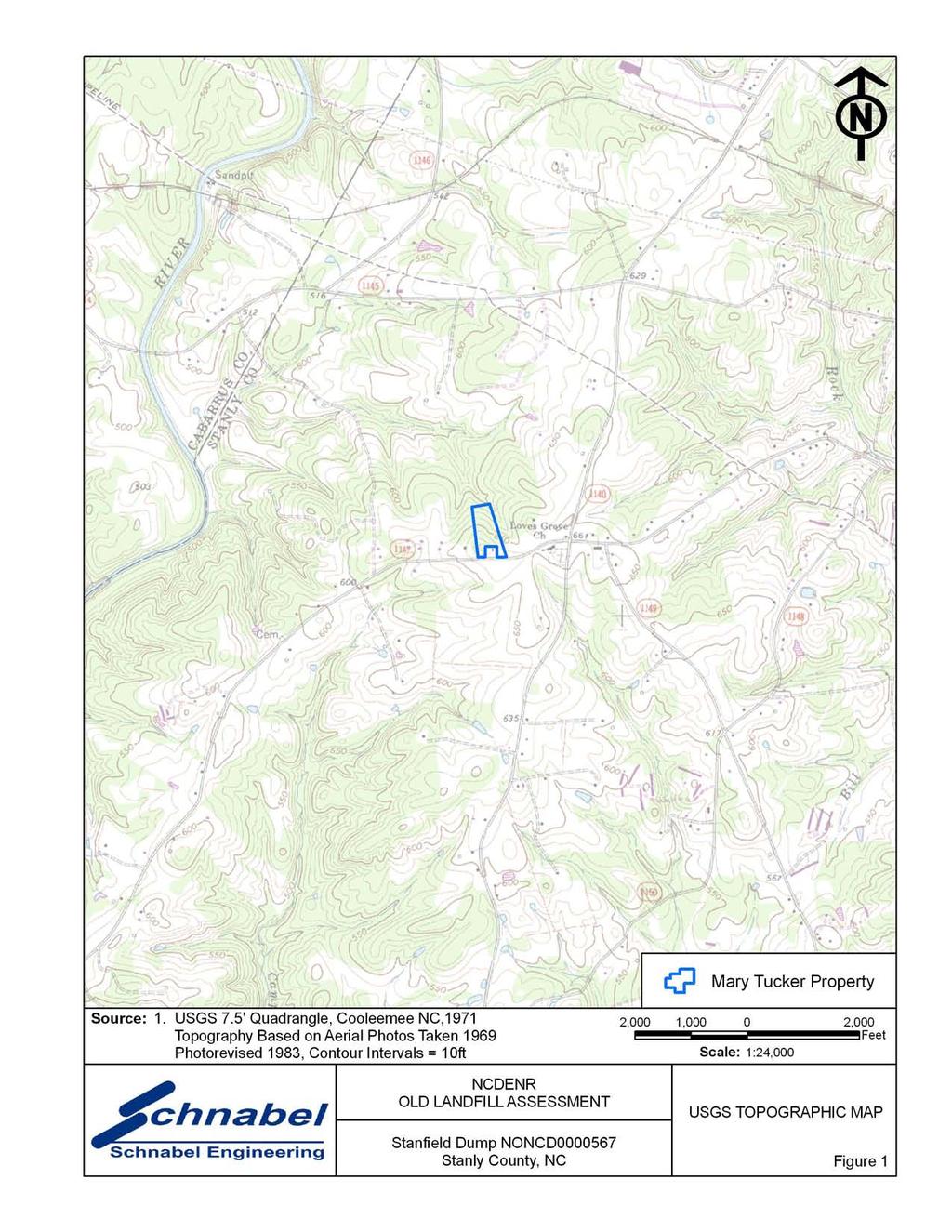
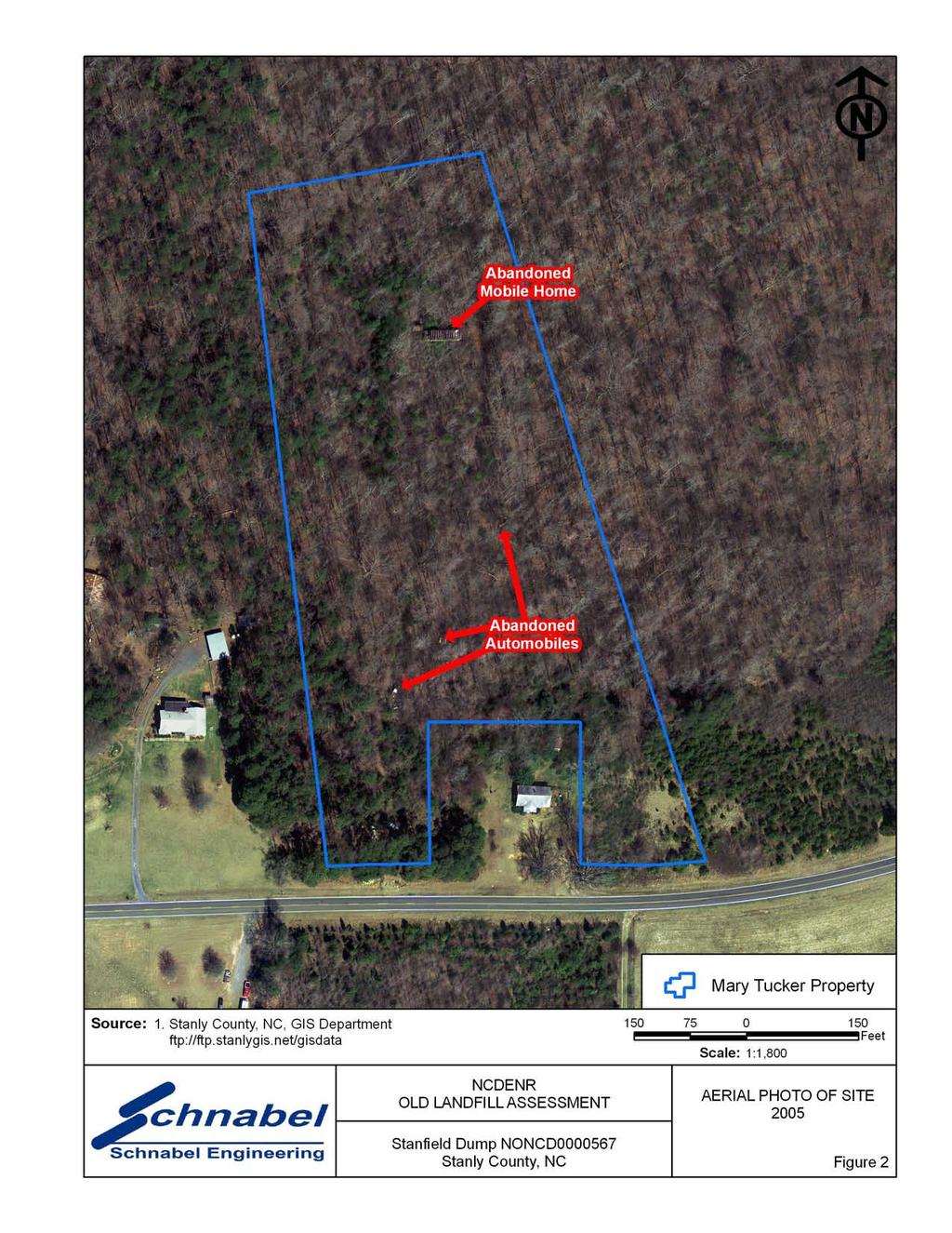
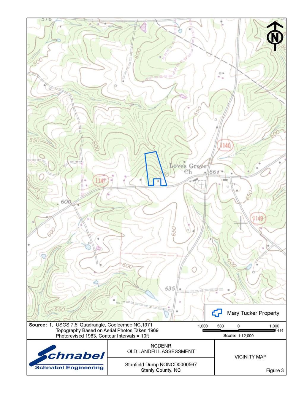
1 11-A Oak Branch Drive Greensboro, NC December 4, 2009 Phone: (336) Fax: ( Mr. Bruce Lefler NCDENR, Division of Waste Management 1646 Mail Service Center Raleigh, NC SUBJECT: State Contract No.: N06009S; Schnabel Project No.: NONCD , Stanfield Dump, Letter Report Dear Mr. Lefler: NCDENR assigned the evaluation of the Stanfield Dump, NONCD , to Schnabel as part of Task 20 of our old unlined landfills contract. The NCDENR Inventory Sheet provided to us indicated that Stanfield Dump was located on Polk Ford Road (SR 1147) east of Loves Chapel Road (SR 1001, also known as Loves Mill Road) in the Town of Stanfield in Stanly County. Based on our assessment from interviews conducted in the vicinity of Loves Grove Church and Polk Ford Road, interviews with residents and town officials, and research of a property owned by Ms. Mary Tucker, we did not find evidence of a Stanfield Dump in Stanly County. The location coordinates provided to us by NCDENR placed the Stanfield Dump on a housing development called Renee Ford Road Plantation. Interviews with Mr. Tom Tucker, Stanfield Public Works Director, Wendell Talley, lifetime resident and farmer, and Ms. Mary Tucker, lifetime resident, stated that they were not aware of a landfill at this location. A review of aerial photographs also did not indicate the presence of a landfill. Mr. Tom Tucker, Stanfield Public Works Director, stated that Stanfield Dump may be located along Polk Ford Road just beyond Loves Grove Church in a wooded area on the right hand side of the road. Mr. Tucker, in a later interview, also stated that he could not pin point the location of the landfill, and that it may not exist. The property which Mr. Tucker described is owned by Ms. Mary Tucker who has no relation to Tom Tucker. Ms. Mary Tucker, Property Owner, stated that she lived on the property with her parents for 30 years and has owned the property for over 40 years, and was not aware of a landfill on the property. She stated that an abandoned mobile home was located on the property and several autos were left by her son, Eddie Tucker, during an auto repair business he ran. She stated that the family placed a small amount of household trash in a gully near the mobile home. She stated that the Town and area residents did not place trash on her property.

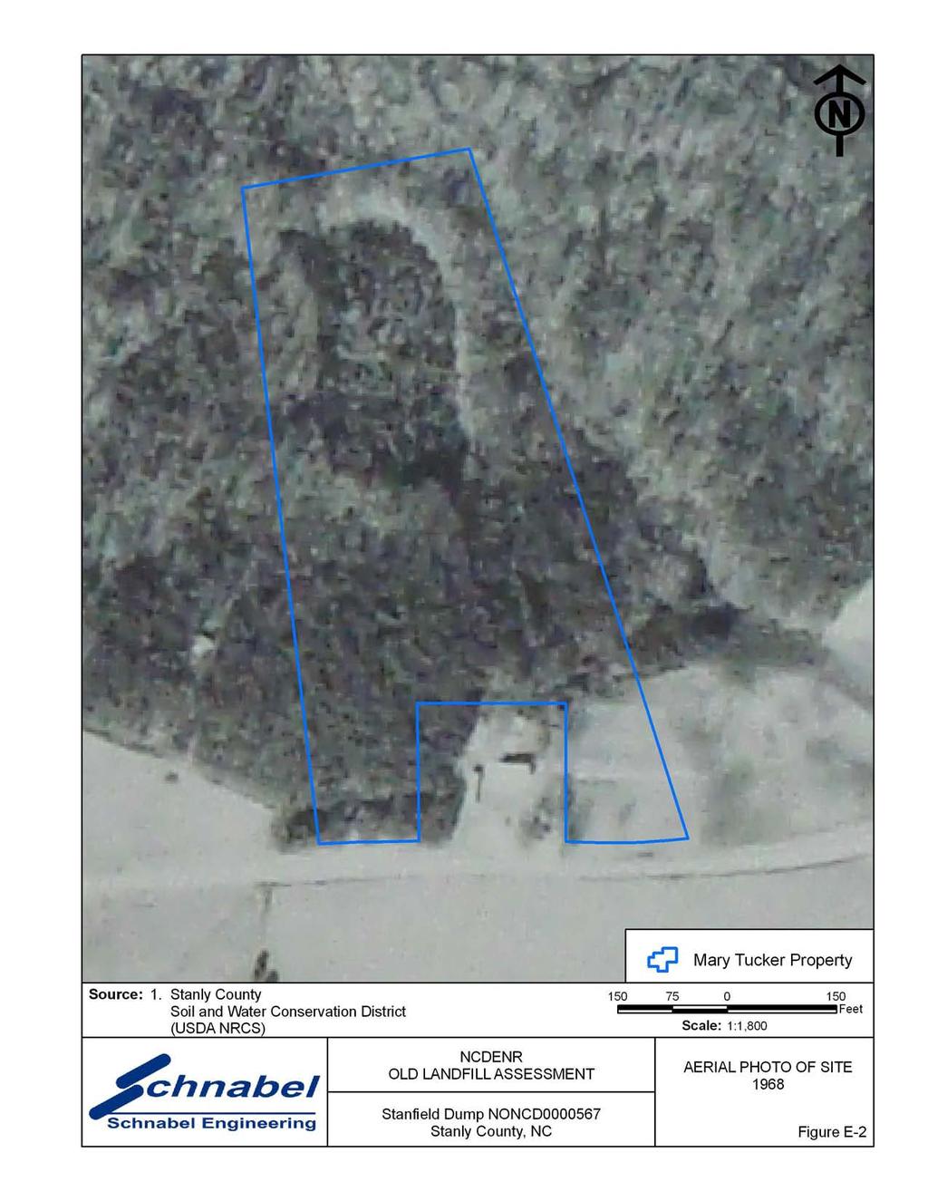
2 On November 24, 2009 Schnabel personnel met with Chris Tucker, grandson of Mary Tucker, to walk the property and look for evidence of an old landfill. An abandoned mobile home and several abandoned autos and various auto parts were observed on the property. Most of the debris appeared to be on the surface and some debris was covered with a thin layer of dirt and leaves. A second area of debris was observed in a small gully near the mobile home. The observed debris in the gully included a washing machine, some glass, and metal debris. Disturbed ground and unnatural topography were not observed. A review of the 1956 and 1968 historical aerial photographs showed a rectangular area of different vegetation on the north central part of the Site. Mr. Tucker stated that this area was cleared of trees during the time his grandparents lived in the mobile home. Features typical of an old unlined landfill were not observed on Ms. Tucker s property. Attached are the Old Landfill Inventory Sheet, Records of Conversation with area residents and officials, Site Access Permission Letter, a site map (Figure 1) showing the location of the Tucker property (Tax Parcel Number ), and a USGS topographic map and vicinity map (Figures 1 and 2). Historical aerial photographs are also included (Figures E-1 and E-2) which show the Tucker property and vicinity. If you need additional information concerning this site, or have any questions, please contact us. Sincerely, Benjamin L. Bradley Project Scientist BB/GR Attachments: Old Landfill Inventory Sheet Site Access Permission Letter Records of Conversation Site Map (Figure 1) USGS Topographic Map (Figure 2) Vicinity Map (Figure 3) Historical Aerial Photographs (Figures E-1 and E-2) FILE:G:\2006_PROJECTS\ _(NCDENR_OLD_UNLINED_LANDFILL)\TASK_20_STANLY_CO\0567- STANFIELDDUMP\REPORT\FINAL\NONCD _STANFIELDDUMP_FINALLETTERREPORT_ DOC 2
3
4
5
6 RECORD OF CONVERSATION INTERVIEW SCHNABEL STAFF: Ben Bradley DATE/TIME: November 11, 2009 INTERVIEW WITH: Mr. Wendell Talley PHONE NO.: TITLE: Farmer FAX NO.: ORGANIZATION: Wendell Talley Turkey Farm ADDRESS: P.O. Box 157, Stanfield, NC PROJECT: NC DENR Old Unlined Landfill Assessments SITE NAME AND NCDENR ID NO.: Stanfield Dump, NONCD SUBJECT: Interview NOTES: On November 11, 2009 Ben Bradley interviewed Wendell Talley, local turkey farmer, about his knowledge of Stanfield Dump. Mr. Talley stated that he has lived in the area all of his life (65 years +). Mr. Talley stated that he had no knowledge of an old landfill operated by the Town of Stanfield. Mr. Talley stated that he was not aware of a landfill near Loves Grove Church, on Polk Ford Road, or on Ms. Mary Tucker s property. G:\2006_projects\ _(NCDENR_Old_Unlined_Landfill)\Task_20_Stanly_Co\0567-StanfieldDump\Report\Final\RecOfConv- WendellTally doc
7 RECORD OF CONVERSATION INTERVIEW SCHNABEL STAFF: Ben Bradley DATE/TIME: November 11, 2009 INTERVIEW WITH: Mr. Tom Tucker PHONE NO.: TITLE: Public Works Director FAX NO.: ORGANIZATION: Town of Stanfield ADDRESS: 103 W. Stanly Street, Stanfield, NC PROJECT: NC DENR Old Unlined Landfill Assessments SITE NAME AND NCDENR ID NO.: Stanfield Dump, NONCD SUBJECT: Interview NOTES: On November 11, 2009 Ben Bradley interviewed Tom Tucker, Stanfield Public Works Director, about his knowledge of Stanfield Dump. Mr. Tucker stated that he has been working for the Town of Stanfield for over 30 years. Mr. Tucker stated that he had heard of a landfill somewhere along Polk Ford Road past Loves Grove Church on the right hand side of the road in the woods. Mr. Tucker stated that he could not pin point the location of the landfill. On November 24, 2009 Ben Bradley interviewed Mr. Tucker a second time about his knowledge of Stanfield Dump and his statement about the landfill being located along Polk Road. Mr. Tucker stated that it was so long ago and his knowledge of it was so vague that he couldn t help me pin point the location of the dump. Mr. Tom Tucker has no relation to Chris or Mary Tucker. G:\2006_projects\ _(NCDENR_Old_Unlined_Landfill)\Task_20_Stanly_Co\0567-StanfieldDump\Report\Final\RecOfConv- TomTucker doc
8 RECORD OF CONVERSATION SITE ACCESS PERMISSION-INTERVIEW SCHNABEL STAFF: Ben Bradley DATE/TIME: November 24, 2009 INTERVIEW WITH: Ms. Mary Tucker PHONE NO.: TITLE: Property Owner FAX NO.: ORGANIZATION: ADDRESS: 2238 Lanier Avenue, Charlotte, NC PROJECT: NC DENR Old Unlined Landfill Assessments SITE NAME AND NCDENR ID NO.: Stanfield Dump, NONCD SUBJECT: Site Access Permission-Interview NOTES: On November 24, 2009 Ben Bradley interviewed Ms. Mary Tucker, Property Owner, about her knowledge of Stanfield Dump. Ms. Mary Tucker gave permission to access her property on Polk Ford Road. Ms. Tucker stated that she lived on the property with her parents for 30 years and has owned the property for over 40 years. Ms. Tucker stated that she was not aware of a landfill on her property or in the Town of Stanfield. Ms. Tucker stated that an abandoned mobile home was located on the property and several autos were left by her son, Eddie Tucker, during an auto repair business he ran. Ms. Tucker stated that the family placed a small amount of household trash in a gully near the mobile home. Ms. Tucker stated that the Town and area residents did not place trash on her property. G:\2006_projects\ _(NCDENR_Old_Unlined_Landfill)\Task_20_Stanly_Co\0567-StanfieldDump\Report\Final\RecOfConv- MaryTucker doc
9 RECORD OF CONVERSATION INTERVIEW SCHNABEL STAFF: Ben Bradley DATE/TIME: November 25, 2009 INTERVIEW WITH: Mr. Chris Tucker PHONE NO.: TITLE: Grandson of Property Owner FAX NO.: ORGANIZATION: ADDRESS: 4325A Polk Ford Road, Stanfield, NC PROJECT: NC DENR Old Unlined Landfill Assessments SITE NAME AND NCDENR ID NO.: Stanfield Dump, NONCD SUBJECT: Interview NOTES: On November 25, 2009 Ben Bradley interviewed Chris Tucker, Grandson of Property Owner, about his knowledge of Stanfield Dump. Based on the interview with Tom Tucker, Town of Stanfield Public Works Director, this property was visited because it was the only property past Loves Grove Church which was wooded and met the description provided by Mr. Tucker. Mr. Tom Tucker has no relation to Chris or Mary Tucker. Mr. Chris Tucker stated that his grandmother grew up on the property and that there was an old trailer on the northern part of the property. Mr. Tucker stated that a shed was located on the property where his father had run an old auto maintenance shop. Mr. Tucker stated that several old autos and auto parts remained on the property. Mr. Tucker stated that trees were cleared from the property during the time his grandparents lived in the mobile home. Mr. Tucker was not aware of a landfill on the property. G:\2006_projects\ _(NCDENR_Old_Unlined_Landfill)\Task_20_Stanly_Co\0567-StanfieldDump\Report\Final\RecOfConv- ChrisTucker doc
10
11
12
13
14
SITE SUMMARY REPORT Troy Landfill NONCD Montgomery County
 SITE SUMMARY REPORT Troy Landfill NONCD 0000436 Montgomery County Senate Bill 1492 State of North Carolina State Contract N06009S Schnabel Project No. 06210002.23 March 8, 2010 Prepared for: North Carolina
Table 1: Margarita (SDSU) Communication Site. Latitude 1 Longitude 1 Elev 2 Address T/R/S 3 APN 4 USGS Quadrangle
 Communication Site. Latitude 1 Longitude 1 Elev 2 Address T/R/S 3 APN 4 USGS Quadrangle") County of Riverside Public Safety Enterprise Communication Project Appendix A: Candidate Site Descriptions Margarita (SDSU) Communication Site Margarita (SDSU) Communication Site Overview The site is located
County of Riverside Public Safety Enterprise Communication Project Appendix A: Candidate Site Descriptions Margarita (SDSU) Communication Site Margarita (SDSU) Communication Site Overview The site is located
Triangle Land Conservancy Conservation Area Monitoring Report Carolina North
 Triangle Land Conservancy Conservation Area Monitoring Report Carolina North Property Name: Crow Branch Conservation Area Date of visit: March 16, 2016 County: Orange Property Type: Restrictive Covenants
Table 1: Margarita (MWD) Communication Site. Latitude 1 Longitude 1 Elev 2 Address T/R/S 3 APN 4 USGS Quadrangle
 Communication Site. Latitude 1 Longitude 1 Elev 2 Address T/R/S 3 APN 4 USGS Quadrangle") County of Riverside Public Safety Enterprise Communication Project Appendix A: Candidate Site Descriptions Margarita (MWD) Communication Site Margarita (MWD) Communication Site Overview The site is located
County of Riverside Public Safety Enterprise Communication Project Appendix A: Candidate Site Descriptions Margarita (MWD) Communication Site Margarita (MWD) Communication Site Overview The site is located
Triangle Land Conservancy Conservation Area Monitoring Report Carolina North
 Triangle Land Conservancy Conservation Area Monitoring Report Carolina North Property Name: Crow Branch Conservation Area Date of visit: 4/8/2015 County: Orange Property Type: Restrictive Covenants Local
Table 1: Santiago Peak Communication Site. Latitude 1 Longitude 1 Elev 2 Address T/R/S 3 APN 4 USGS Quadrangle
 County of Riverside Public Safety Enterprise Communication Project Appendix A: Candidate Site Descriptions Overview The site is located in the Cleveland National Forest (CNF) at an existing communication
FIGURES. Former Hoppy s Paint & Body and Knat s Barber Shop City of Plant City. CSI Job No C
 FIGURES Former Hoppy s Paint & Body and Knat s Barber Shop City of Plant City CSI Job No. 9680.33 C INFERRED EXTENT OF ARSENIC IMPACTED SOIL C.A. No. 262 Additional Soil Assessment Activities 607, 609,
Triangle Land Conservancy Conservation Area Monitoring Report Carolina North
 Triangle Land Conservancy Conservation Area Monitoring Report Carolina North Property Name: Bolin Creek East Conservation Area Date of visit: March 16, 2017 County: Orange Property Type: Restrictive Covenants
Triangle Land Conservancy Conservation Area Monitoring Report Carolina North
 Triangle Land Conservancy Conservation Area Monitoring Report Carolina North Property Name: Bolin Creek West Conservation Area Date of visit: March 16, 2017 County: Orange Property Type: Restrictive Covenants
Address 347 Whitney Street. East elevation, camera facing southwest.
 FORM B BUILDING Assessor s Number USGS Quad Area(s) Form Number MASSACHUSETTS HISTORICAL COMMISSION MASSACHUSETTS ARCHIVES BUILDING 220 MORRISSEY BOULEVARD BOSTON, MASSACHUSETTS 02125 Town Northborough
The site is located on federal land managed by the USFS, and is subject to the San Bernardino National Forest Management Plan (SBNFMP).
.") County of Riverside Public Safety Enterprise Communication Project Appendix A: Candidate Site Descriptions Overview The site is located near an existing County communication tower and USFS lookout tower
County of Riverside Public Safety Enterprise Communication Project Appendix A: Candidate Site Descriptions Overview The site is located near an existing County communication tower and USFS lookout tower
Table 1: Avocado Flats Communication Site. Latitude 1 Longitude 1 Elev 2 Address T/R/S 3 APN 4 USGS Quadrangle
 County of Riverside Public Safety Enterprise Communication Project Appendix A: Candidate Site Descriptions Overview The candidate area is located in Northern San Diego County, 0.65 mile south of the border
Table 1: Black Eagle Communication Site. Latitude 1 Longitude 1 Elev 2 Address T/R/S 3 APN 4 USGS Quadrangle
 County of Riverside Public Safety Enterprise Communication Project Appendix A: Candidate Site Descriptions Overview The site is located on a previously graded and benched plateau within the Black Eagle
Table 1: Rancho Carrillo Communication Site. Latitude 1 Longitude 1 Elev 2 Address T/R/S 3 APN 4 USGS Quadrangle
 County of Riverside Public Safety Enterprise Communication Project Appendix A: Candidate Site Descriptions Overview The site is located in the Cleveland National Forest (CNF) atop a low ridge adjacent
Part One - Numbers 1 to 5 Listen to the following dialogues. For questions 1 to 5, choose the correct picture. Mark A, B or C on your Answer Sheet.
 Listening Part One - Numbers 1 to 5 Listen to the following dialogues. For questions 1 to 5, choose the correct picture. 1. Where is the new student from? England Italy Spain 2. What does the man want
County of San Bernardino Film Permit Information
 County of San Bernardino Film Permit Information Dear Permit Applicant: The following is information about the County of San Bernardino Filming Permit Application. Enclosed you will also find a Filmmakers
Melanie. Persona. Hotel Manager. I need to make sure the hotel is ran efficiently and provides the services to make our guests comfortable.
 Story A hotel manager is looking for an easy to use tool that allows them to efficiently manage and be a proactive guest services organization; while providing a simple way for guests to make the requests.
Triangle Land Conservancy Conservation Area Monitoring Report Carolina North
 Triangle Land Conservancy Conservation Area Monitoring Report Carolina North Property Name: Bolin Creek East Conservation Area Date of visit: 4/8/2015 County: Orange Property Type: Restrictive Covenants
Alberta Turner sits in front of her damaged home in White Hall.
 Photos by Mickey Welsh, Advertiser Alberta Turner sits in front of her damaged home in White Hall. Tommy Turner shows the roof damage to his mother s home. May 29, 2008 Woman's home of 30 years damaged
PCBS DELINEATION WORK PLAN
 PCBS DELINEATION WORK PLAN BLUE ISLAND NORTHEAST MIXED-USE COMMERCIAL PARK (FORMER BLUE ISLAND LANDFILL) BLUE ISLAND, COOK COUNTY, ILLINOIS PREPARED FOR: CITY OF BLUE ISLAND 13051 SOUTH GREENWOOD AVENUE
February Dear Parents and Pennrose Employees,
 February 2019 Dear Parents and Pennrose Employees, The Pennrose Foundation believes that all children can benefit from a summer camp experience, especially those who may otherwise be unable to attend due
ARCHAEOLOGICAL MONITORING OF THE ASHBY STREET DRAINAGE PROJECT, SAN ANTONIO, BEXAR COUNTY, TEXAS
 ARCHAEOLOGICAL MONITORING OF THE ASHBY STREET DRAINAGE PROJECT, SAN ANTONIO, BEXAR COUNTY, TEXAS Anne A. Fox and I. Waynne Cox / Center for Archaeological Research The University of Texas at San Antonio
MP : The Empire Toll Gate and Glen Arbor
 MP 255 256: The Empire Toll Gate and Glen Arbor This section includes the location of the Empire Toll Gate, Glen Arbor and a reservoir. Route Mile Marker X Y Longitude Latitude 1 U. S. Highway 40 255 439593.25
Table 1: Iron Mountain Communication Site. Latitude 1 Longitude 1 Elev 2 Address T/R/S 3 APN 4 USGS Quadrangle
 County of Riverside Public Safety Enterprise Communication Project Appendix A: Candidate Site Descriptions Overview The site is located in San Bernardino County near several communication towers in the
Re: Environmental Assessment Registration Terra Nova Road Quarry File Ref No
 EA Registration Terra Nova Road Quarry File Ref No. 200.20.2528 1 April 3, 2017 The Honourable Eddie Joyce Minister of Municipal Affairs and Environment Department of Municipal Affairs and Environment
U.S. CONSUMER PRODUCT SAFETY COMMISSION 5 RESEARCH PLACE ROCKVILLE, MD September 25, 2017
 U.S. CONSUMER PRODUCT SAFETY COMMISSION 5 RESEARCH PLACE ROCKVILLE, MD 20850 Mark Kumagai, P.E. Phone: (301) 987-2234 Division Director, Mechanical and Combustion Engineering email:mkumagai@cpsc.gov September
REF: City Manager s Weekly FYI ~ December 21, 2018
 TO: FROM: Mayor and Members of the City Council Rich Olson, City Manager REF: City Manager s Weekly FYI ~ December 21, 2018 COPY: Email Distribution 1. This will be the last FYI for 2018. I would like
1803 West Hwy 160 Monte Vista, CO (719) TTY (719)
 TTY (719)") USDA Forest Service Rio Grande National Forest http://www.fs.fed.us/r2/riogrande 1803 West Hwy 160 Monte Vista, CO 81144 (719)852-5941 TTY (719)852-6271 USDI Bureau of Land Management San Luis Valley Center
USDA Forest Service Rio Grande National Forest http://www.fs.fed.us/r2/riogrande 1803 West Hwy 160 Monte Vista, CO 81144 (719)852-5941 TTY (719)852-6271 USDI Bureau of Land Management San Luis Valley Center
MANASSAS REGIONAL AIRPORT
 Appendix E MANASSAS REGIONAL AIRPORT Airport Franchise and Lease Application Return this completed application to: Airport Director, Manassas Regional Airport, P.O. Box 560, Manassas, Virginia 20108 Use
One East First Street Reno, NV
 AECOM City Hall Tower, 16th Floor One East First Street Reno, NV 89501 www.aecom.com 775.337.9565 tel 916.414.5850 fax Mr. David Whalen, P.E. City of Fernley Public Works 595 Silverlace Blvd. Fernley,
David Magney Environmental Consulting
 David Magney Environmental Consulting DELINEATION OF JURISDICTIONAL WATERS AND RIPARIAN HABITATS FOR LYONS CANYON RANCH, NEWHALL, CALIFORNIA Prepared for: UNITED STATES ARMY CORPS OF ENGINEERS and CALIFORNIA
MORGAN CREEK GREENWAY Final Report APPENDICES
 APPENDICES MORGAN CREEK GREENWAY Appendix A Photos of Existing Conditions in Trail Corridor Photos of existing conditions Main trail corridor - February 2009 Photos of existing conditions south bank Morgan
 Appendix A - Locations and Photographs of AES Coal Ash Waste Disposal Sites in and Around Guayama, Puerto Rico Site 1: Rural Route PR-713 Km 3.3 Cimarrona Ward, Guayama, PR o Latitude/Longitude: 17.99616231,
CROWN LAND INTERESTS RELANS Conference Halifax, Nova Scotia February 2, 2006
 CROWN LAND INTERESTS 2006 RELANS Conference Halifax, Nova Scotia February 2, 2006 PRESENTATION OUTLINE HISTORY Dave Steeves, NSLS, ACLS, P.Eng Director, Land Administration, DNR CROWN LANDS ACT Amy Parker
Preliminary Site Evaluation
 Preliminary Site Evaluation 100 Acre Site, US 72 Piperton, Tennessee Power Distributor: Chickasaw Electric Cooperative August 2010 SITE DATA SHEET PIPERTON US 72 SITE (100 ACRES): LOCATION & GENERAL DESCRIPTION
Canal Steward Program Adoption Package
 National Park Service U.S. Department of the Interior Chesapeake and Ohio Canal National Historical Park 1850 Dual Highway, Suite 100 Hagerstown, MD 21740 301-745-5810 phone 301-739-6179 fax Canal Steward
David Johnson. Tom, Attached please find the final scoping letter and figures for your review. David
 David Johnson From: Sent: To: Cc: Subject: Attachments: David Johnson Tuesday, April 12, 2011 4:33 PM Thomas Malecek Dave Dyer; Jason Marks (jmarks@segroup.com) VWC Scoping Letter
The President James K. Polk State Historic Site Teacher s Packet
 The President James K. Polk State Historic Site Teacher s Packet 2008-2009 Mailing Address: PO Box 475 Pineville, NC 28134 Street Address: 12031 Lancaster Highway Pineville, NC 28134 (704) 889-7145 phone
Mountain Valley Pipeline, LLC Mountain Valley Pipeline Project Docket No. CP
 16. Prior to construction, Mountain Valley shall file with the Secretary, for review and approval by the Director of OEP, a segment-specific construction and operation access plan for the area between
National No. 2 (Bob Ciminel 2012)
") National No. 2 (Bob Ciminel 2012) Coming timetable east out of Muse Junction, we begin ascending the 1% grade to National Tunnel at MP 27. After passing through the tunnel s 823-foot bore we begin our
National No. 2 (Bob Ciminel 2012) Coming timetable east out of Muse Junction, we begin ascending the 1% grade to National Tunnel at MP 27. After passing through the tunnel s 823-foot bore we begin our
COMMUNITY APPEARANCE INDEX (Formerly: Litter Index) CITY OF ATLANTA 2014
 CITY OF ATLANTA 2014") COMMUNITY APPEARANCE INDEX (Formerly: Litter Index) CITY OF ATLANTA 2014 Keep Atlanta Beautiful has completed its ninth Litter Index and fourth Community Appearance Index, an expansion of the Litter Index,
COMMUNITY APPEARANCE INDEX (Formerly: Litter Index) CITY OF ATLANTA 2014 Keep Atlanta Beautiful has completed its ninth Litter Index and fourth Community Appearance Index, an expansion of the Litter Index,
Community Development Department Council Chambers, 7:30 PM, July 16, 2015
 STAFF REPORT 2015-25P: Zoning Chapter Amendment Community Development Department Council Chambers, 7:30 PM, July 16, 2015 To: From: Case: Paul Luke, Chairman, Skokie Plan Commission Steve Marciani, Planning
Guide to the Ruthe Scott Photographs of Las Vegas, Nevada Hotels and Casinos
 Guide to the Ruthe Scott Photographs of Las Vegas, Nevada Hotels and Casinos This finding aid was created by Lindsay Oden on April 27, 2018. Persistent URL for this finding aid: http://n2t.net/ark:/62930/f1q913
TOWN OF SWANSBORO Planning Board Regular Meeting Community Room AGENDA
 TOWN OF SWANSBORO Planning Board Regular Meeting Community Room April 4, 2016 Monday 6:00 pm Town Hall 601 W. Corbett Ave. AGENDA 1. Call to Order 2. Roll Call and Quorum Verification 3. Approval of Meeting
Monthly Board of Directors Meeting May 11, 2010
 Monthly Board of Directors Meeting May 11, 2010 The Bay Tree Property Owner s Association, Inc Board of Directors monthly meeting was held at the Club House on Tuesday May 11, 2010. The following Board
Town: Sharon Place (neighborhood or village): Sharon. ame of Area: Present Use: Date (month / year): July 2008
: Sharon. ame of Area: Present Use: Date (month / year): July 2008") FORM A - AREA MASSACHUSETTS HISTORICAL COMMISSION MASSACHUSETTS ARCHIVES BUILDING 220 MORRISSEY BOULEVARD BOSTON, MASSACHUSETTS 02125 Photograph Assessor s Sheets USGS Quad Area Letter Form Numbers in
FORM A - AREA MASSACHUSETTS HISTORICAL COMMISSION MASSACHUSETTS ARCHIVES BUILDING 220 MORRISSEY BOULEVARD BOSTON, MASSACHUSETTS 02125 Photograph Assessor s Sheets USGS Quad Area Letter Form Numbers in
Urquhart Castle. Sources Baxter, Colin. Castles of Scotland. ISBN
 Urquhart Castle What was once one of the largest castles in Scotland is now considered by many to be one of the most beautiful castle ruins. Urquhart (ur-kurt) Castle was one of the 1200 stone castles
Minutes- Board of Directors JUNE 5, 2018 Page 1
 LUBBOCK COUNTY WATER CONTROL & IMPROVEMENT DISTRICT NO. 1 9999 High Meadow Road Lubbock, TX 79404 Administration Office: (806)747-3353 Fax:(806)747-3714 Minutes CALLED MEETING OF THE BOARD OF DIRECTORS
Auto Repair Business, Real Estate & Equipment
 For Sale OWNER WILL CARRY FINANCING FOR QUALIFIED BUYER!!! Auto Repair Business, Real Estate & Equipment Features: Sales Price: $650,000.00 Building Size: 7,675+/- SF Lot Size: 15,000+/- SF Highlights:
State Level Historic Documentation Report. John Blue Bridge Hampshire County
 State Level Historic Documentation Report State Project No. S314-28-22.27 Federal Project No. BR-0028(058)D John Blue Bridge Hampshire County Prepared by: Randy Epperly, Historian Department of Transportation
COMMITTEE OF ADJUSTMENT FOR MINOR VARIANCE MINUTES Monday July 26, :30 p.m Town Council Chambers Page 1
 Page 1 1. CALL TO ORDER Acting Committee Chair W. Moore called the meeting to order at 5:30 p.m. and the following were recorded as being present. Committee Members: Staff: Committee Member, K. Parlett
PUBLIC MINUTES PROPERTY MAINTENANCE APPEALS BOARD. Tuesday, December 13, 2016, 3:29 p.m. Committee Room B, City Hall
 PUBLIC MINUTES PROPERTY MAINTENANCE APPEALS BOARD Tuesday,, 3:29 p.m. Committee Room B, City Hall PRESENT: ABSENT: ALSO PRESENT: Mr. Ian Oliver, Chair Mr. Roy Fleming, Member Mr. Donald Stiller, Member
MP : Snowy Range Road and the Hoop Creek Bridge
 MP 246 247: Snowy Range Road and the Hoop Creek Bridge This section of U. S. Highway 40 contains a Colorado treasure, a great photo op, and a historical landmark all at one stop. It s the Hoop Creek Stone
Agency Information Collection Activities; Extension, Without Change, of a Currently
 This document is scheduled to be published in the Federal Register on 01/19/2018 and available online at https://federalregister.gov/d/2018-00830, and on FDsys.gov Billing Code 9111-97 DEPARTMENT OF HOMELAND
Municipal Yard & Bulky Waste Policies
 Municipal Yard & Bulky Waste Policies Bedminster Wood and Brush- Fourth Monday in April Please go to www.bedminster.us for complete policy Leaves- Last week in October through November 30th on regular
AIRPORT MASTER PLAN. Newport State Airport. Draft. (Colonel Robert F. Wood Airpark) THE Louis Berger Group, INC. Prepared for: Prepared by:
 THE Louis Berger Group, INC. Prepared for: Prepared by:") Draft AIRPORT MASTER PLAN Newport State Airport () Prepared for: 2000 Post Road Warwick, Rhode Island 02886-1533 THE Louis Berger Group, INC. 20 Corporate Woods Boulevard Albany, New York 12211-2370 Prepared
Draft AIRPORT MASTER PLAN Newport State Airport () Prepared for: 2000 Post Road Warwick, Rhode Island 02886-1533 THE Louis Berger Group, INC. 20 Corporate Woods Boulevard Albany, New York 12211-2370 Prepared
CAA Soccer Board Meeting Date of Meeting: August 12, 2012 (Sunday) Meeting Called to Order: 7:40 p.m. Meeting Adjourned:
 Meeting Called to Order: 7:40 p.m. Meeting Adjourned:") CAA Soccer Board Meeting Date of Meeting: August 12, 2012 (Sunday) Meeting Called to Order: 7:40 p.m. Meeting Adjourned: List of Attendees President: Chris Neeley Vice President: Don Rahn Secretary: David
CAA Soccer Board Meeting Date of Meeting: August 12, 2012 (Sunday) Meeting Called to Order: 7:40 p.m. Meeting Adjourned: List of Attendees President: Chris Neeley Vice President: Don Rahn Secretary: David
DAVIDSON LACROSSE CAMP for GIRLS Box 7158, Davidson, NC * (704) Phone * (704) Fax
 Phone * (704) Fax") CAMP INFORMATION GIRLS GRADES 7-12: Monday, July 11 th, 2016 Wednesday, July 13 th, 2016 Check-in @ 12:30pm; Check-out @ 2:30pm DUKE RESIDENCE HALL Camp begins at 2:00pm SHARP and ends at 2:30pm Airport
CAMP INFORMATION GIRLS GRADES 7-12: Monday, July 11 th, 2016 Wednesday, July 13 th, 2016 Check-in @ 12:30pm; Check-out @ 2:30pm DUKE RESIDENCE HALL Camp begins at 2:00pm SHARP and ends at 2:30pm Airport
WORLD TRADE CENTER TASK FORCE INTERVIEW. BATTALION CHIEF DOMINICK DeRUBBIO. Interview Date: October 12, Transcribed by Laurie A.
 File No. 9110064 WORLD TRADE CENTER TASK FORCE INTERVIEW BATTALION CHIEF DOMINICK DeRUBBIO Interview Date: October 12, 2001 Transcribed by Laurie A. Collins MR. CUNDARI: The time is 10:15, and this is
Action Recommendation: Budget Impact:
 City of Fayetteville Staff Review Form 2018-0600 Legistar File ID 11/8/2018 City Council Meeting Date - Agenda Item Only N/A for Non-Agenda Item Leif Olson 10/17/2018 SUSTAINABILITY/RESILIENCE (631) Submitted
Bradley Brook Relocation Project. Scoping Notice. Saco Ranger District. United States Department of Agriculture Forest Service
 Bradley Brook Relocation Project United States Department of Agriculture Forest Service Scoping Notice White Mountain National Forest February 2011 For Information Contact: Jenny Burnett White Mountain
The Holes Creek Bridge Replacement By Bradley McClelland
 The Holes Creek Bridge Replacement By Bradley McClelland Each time there is a heavy rainstorm, the folks along Sheffield Road in the Dayton, Ohio suburb of West Carrollton have cause to be concerned. Holes
NORTH HORSHAM PARISH COUNCIL SCHEDULE OF PLANNING APPLICATIONS FOR CONSIDERATION 4 th AUGUST 2016
 NORTH HORSHAM PARISH COUNCIL SCHEDULE OF PLANNING APPLICATIONS FOR CONSIDERATION 4 th AUGUST 2016 DC/16/0995 Site Address: 29, Greenfields Road Proposal: Erection of a single storey side kitchen extension
2.0 Historical Summary
 2.0 Historical Summary 2.1 Introduction The following historical analysis contributes to the assessment of cultural significance of the site at 753 755 Darling Street Rozelle. The information is drawn
Travel Diary, De Panne, Belgium
 Travel Diary, De Panne, Belgium 18.02.18-24.02.18 Monday 19.02.18 by Kjell Effenberger 12L School started 08:30: Meeting all together with other students from the sustain.me Erasmus + project. There we
Guide to the Tonopah Mining Company Records
 This finding aid was created by Joyce Moore on October 25, 27. Persistent URL for this finding aid: http://n2t.net/ark:/62930/f1x629 27 The Regents of the University of Nevada. All rights reserved. University
V.2013 QUICK REFERENCE
 CRUISE PLAN V.2013 QUICK REFERENCE Cruise Plan is a tool for planning your cruise, logging the metadata for each sampling event and transmitting this data to the program database when the cruise is completed.
WASHTENAW COUNTY WATER RESOURCES COMMISSIONER FOUR MILE LAKE LAKE LEVEL PUBLIC MEETING
 WASHTENAW COUNTY WATER RESOURCES COMMISSIONER FOUR MILE LAKE LAKE LEVEL PUBLIC MEETING NAME OF DRAIN: Four Mile Lake Lake Level ENGINEER: DATE/TIME: August 15 th, 2018 7pm LOCATION: Dexter Township Hall
Deer, People and Parks
 APPENDIX A: Survey instrument Deer, People and Parks A Survey of Residents Living Near Fire Island National Seashore Research conducted by National Park Service Biological Resource Management Division
Attachment G STREAM IMPACTS. Ridge Road Extension Alternatives Analysis
 Attachment G STREAM IMPACTS for: Ridge Road Extension Alternatives Analysis PREPARED FOR: Pasco County Engineering Services Department PREPARED BY: NV5, INC. 6989 E. FOWLER AVENUE TAMPA, FLORIDA 33617
Please use these following tips / practices to reduce the burden on our system
 Mecklenburg UCC North Carolina 811 is the 2 nd largest call center for ticket volume in the country. Everyone needs to work together, to assist in helping locators with the influx of locate tickets.
Corporate Environmental Leadership Seminar Yale School of Forestry & Environmental Studies June 4-15, 2000
 KLEE 443 Corporate Environmental Leadership Seminar Yale School of Forestry & Environmental Studies June 4-15, 2000 Robert J. Klee M.E.S., Yale School of Forestry & Environmental Studies, 1999 ECO-INDUSTRIAL
[Docket No. FAA ; Product Identifier 2018-NM-085-AD; Amendment ; AD R1]
![[Docket No. FAA ; Product Identifier 2018-NM-085-AD; Amendment ; AD R1]](/thumbs/90/104439622.jpg "[Docket No. FAA ; Product Identifier 2018-NM-085-AD; Amendment ; AD R1]") [Federal Register Volume 83, Number 227 (Monday, November 26, 2018)] [Rules and Regulations] [Pages 60337-60339] From the Federal Register Online via the Government Publishing Office [www.gpo.gov] [FR
[Federal Register Volume 83, Number 227 (Monday, November 26, 2018)] [Rules and Regulations] [Pages 60337-60339] From the Federal Register Online via the Government Publishing Office [www.gpo.gov] [FR
Guide to the Las Vegas City Engineering and Planning Department Records
 Guide to the Las Vegas City Engineering and Planning Department Records This finding aid was created by Ian M. Baldwin and Joyce Moore on September 25, 2017. Persistent URL for this finding aid: http://n2t.net/ark:/62930/f1vg6z
HEADQUARTERS WEST LTD. PHOENIX - TUCSON - SONOITA - COTTONWOOD - ST. JOHNS
 Offered for sale exclusively by: Walter Lane Headquarters West, Ltd. PO BOX 37018 Tucson, AZ 85740 Phone (520) 792-2652 info@headquarterswest.com www.headquarterswest.com General Area Description The Crown
STATE OF IOWA. Historical and Architectural Survey for 2008 Flood Projects in Vinton, Benton County
 STATE OF IOWA CHESTER J. CULVER GOVERNOR PATTY JUDGE LT. GOVERNOR DEPARTMENT OF PUBLIC DEFENSE IOWA HOMELAND SECURITY AND EMERGENCY MANAGEMENT DIVISION DAVID L. MILLER, ADMINISTRATOR Historical and Architectural
CUB ADVENTURE CAMP USE REQUEST Heart of Virginia Council, Boy Scouts of America For Non-Profit Groups or Events
 Heart of Virginia Scout Reservation Camp T. Brady Saunders, Cub Adventure Camp and Camp S. Douglas Fleet 1723 Maidens Rd., Maidens, VA 23102 Mailing Address PO Box 6809 CUB ADVENTURE CAMP USE REQUEST Heart
Guide to the Birckhead collection of Redwood family papers (bulk )
") Page 1 of 8 Guide to the Birckhead collection of Redwood family papers 1730-1866 (bulk 1730-1774) 50 Bellevue Avenue Newport, RI 02840 Tel: (401) 847-0292 Fax: (401) 841-5680 email: redwood@redwoodlibrary.org
Page 1 of 8 Guide to the Birckhead collection of Redwood family papers 1730-1866 (bulk 1730-1774) 50 Bellevue Avenue Newport, RI 02840 Tel: (401) 847-0292 Fax: (401) 841-5680 email: redwood@redwoodlibrary.org
Sawtooth National Forest Fairfield Ranger District
 United States Department of Agriculture Forest Service Sawtooth National Forest Fairfield Ranger District P.O. Box 189 Fairfield, ID. 83327 208-764-3202 Fax: 208-764-3211 File Code: 1950/7700 Date: December
The combat stories of Peter Likanchuk
 The combat stories of Peter Likanchuk Dates in Service: December 1942-1945 Branch of Service: Army Unit: 100 th Infantry Division, 925 th Field Artillery Battalion, Battery B Location: France/Germany Battles/Campaigns:
DEPARTMENT: 1. Father s Name : 2. Mother s Name : 3. Permanent Address : PIN Tel. No.: 4. Address for Correspondence :
 Affix a HOSTEL ALLOTMENT FORM 2016-17 DEPARTMENT: Passport Size Photograph Date: PERSONAL DETAILS 1. Name of the Student : 2. Roll No./ Appn No:/ JEE No : 3. Name of the Degree : 4. Name of the Deptt.
CITY OF LYNN HAVEN CITY COMMISSION MEETING MINUTES OCTOBER 25, :00 P.M.
 The Lynn Haven City Commission held a workshop on Monday, October 24, 2016 at 4:00 p.m. in The Chambers to discuss upcoming special events and a proposed splash park at Kinsaul Park. The public was invited
Logo Department Name Agency Organization Organization Address Information 5700 North Sabino Canyon Road
 Logo Department Name Agency Organization Organization Address Information United States Forest Coronado National Forest 5700 North Sabino Canyon Road Department of Service Santa Catalina Ranger District
Date Printed: 9/22/2010
 For more information contact: Chuck Scragg 770-387-5301 cwscragg@southernco.com Site Name City County Remaining Acres Largest Tract AC Largest Rail Tract AC Zoning Excess Water Capacity MGD SITE SUMMARY
DS-260 Instructions. America World 6723 Whittier Avenue McLean VA ONE-CHILD Fax
 DS-260 Instructions America World 6723 Whittier Avenue McLean VA 22101 888-ONE-CHILD Fax 703-356-8973 5 DS-260 Overview DS-260 Immigrant Visa Application Along with applying for the I800 through USCIS
LOG CABIN (Now at Fiddler s Grove, Lebanon, Tenn.)
") LOG CABIN (Now at Fiddler s Grove, Lebanon, Tenn.) Property and Cabin first owned by Gleaves Family and probably constructed by them John Donelson of the County of Tennessee 640 acres - $600 written 1/11/1796
LOG CABIN (Now at Fiddler s Grove, Lebanon, Tenn.) Property and Cabin first owned by Gleaves Family and probably constructed by them John Donelson of the County of Tennessee 640 acres - $600 written 1/11/1796
Crown Lands and Property Agency. Name Client # LAST (Please Print) FIRST MIDDLE (no initials) Mailing Address. Postal Code
 FIRST MIDDLE (no initials) Mailing Address. Postal Code") Manitoba Conservation and Water Stewardship Application for Permit/Lease/Purchase/Easement/Exchange/Licence of Occupation (under The Crown Lands Act c.c340) Please check one ( ) Permit Lease Purchase Easement
Manitoba Conservation and Water Stewardship Application for Permit/Lease/Purchase/Easement/Exchange/Licence of Occupation (under The Crown Lands Act c.c340) Please check one ( ) Permit Lease Purchase Easement
Planning Commission Meeting Minutes Thursday, January 22, 2009 City Council Chambers 220 East Morris Avenue Time: 7:00 p.m.
 Planning Commission Meeting Minutes Thursday, January 22, 2009 City Council Chambers 220 East Morris Avenue Time: 7:00 p.m. Commission Members Present: Francis Lilly- Conducting Lloyd Anderson Joshua Smith
PERMIT APPLICATION FOR PRIVATE EVENT to be held on public property in the CITY OF ATLANTIC BEACH, FLORIDA
 PERMIT APPLICATION FOR PRIVATE EVENT to be held on public property in the CITY OF ATLANTIC BEACH, FLORIDA Please provide the following information for approval from the City of Atlantic Beach to hold a
COMPLIANCE WITH THIS PUBLICATION IS MANDATORY
 BY ORDER OF THE COMMANDER 30TH SPACE WING 30TH SPACE WING INSTRUCTION 13-205 2 OCTOBER 2006 Certified Current 18 September 2017 Space Missile Command and Control RESTRICTED AREA/DANGER ZONE ENTRY ACCESSIBILITY:
White Mountain National Forest Saco Ranger District
 United States Department of Agriculture Forest Service White Mountain National Forest 33 Kancamagus Highway Conway, NH 03818 Comm: (603) 447-5448 TTY: (603) 447-3121 File Code: 1950 Date: February 26,
SYNOPSIS WEATHER AND SNOWPACK
 Peak 6996 Avalanche Fatality Incident Report Glacier National Park, MT Date of Avalanche: 31 March 2010 Date of Investigation: 2 April 2010 Investigation Team: Erich Peitzsch (USGS), Ted Steiner (Chugach
[Docket No. FAA ; Airspace Docket No. 14-ASO-4] SUMMARY: This action proposes to amend Class E Airspace at Newnan, GA,
![[Docket No. FAA ; Airspace Docket No. 14-ASO-4] SUMMARY: This action proposes to amend Class E Airspace at Newnan, GA,](/thumbs/96/128013796.jpg "[Docket No. FAA ; Airspace Docket No. 14-ASO-4] SUMMARY: This action proposes to amend Class E Airspace at Newnan, GA,") This document is scheduled to be published in the Federal Register on 03/18/2014 and available online at http://federalregister.gov/a/2014-05888, and on FDsys.gov [4910-13] DEPARTMENT OF TRANSPORTATION
This document is scheduled to be published in the Federal Register on 03/18/2014 and available online at http://federalregister.gov/a/2014-05888, and on FDsys.gov [4910-13] DEPARTMENT OF TRANSPORTATION
Guide to the L. F. Manis Photographs
 This finding aid was produced using ArchivesSpace on February 29, 2016. English 2016 The Regents of the University of Nevada. All rights reserved. University of Nevada, Las Vegas. University Libraries.
1430 DeKalb Street, 2 nd Floor Room 2019 Norristown, PA 19404
 University of Pittsburgh, School of Social Work The Pennsylvania Child Welfare Resource Center 403 E. Winding Hill Road, Mechanicsburg, PA 17055 Phone: 717-795-9048 Fax: 717-795-8013 1430 DeKalb Street,
SUPPORT SERVICES GMBH
 Page 1 2011-18-13 328 SUPPORT SERVICES GMBH (TYPE CERTIFICATE PREVIOUSLY HELD BY AVCRAFT AEROSPACE GMBH; FAIRCHILD DORNIER GMBH; DORNIER LUFTFAHRT GMBH) Amendment 39-16795 Docket No. FAA-2010-1163; Directorate
Table 1: Paradise Communication Site. Latitude 1 Longitude 1 Elev 2 Address T/R/S 3 APN 4 USGS Quadrangle
 County of Riverside Public Safety Enterprise Communication Project Appendix A: Candidate Site Descriptions Overview The site is located atop a west-facing ridge overlooking the City of Norco, approximately
[Docket No. FAA ; Directorate Identifier 2012-NM-230-AD; Amendment. Airworthiness Directives; The Boeing Company Airplanes
 This document is scheduled to be published in the Federal Register on 10/02/2013 and available online at http://federalregister.gov/a/2013-24029, and on FDsys.gov [4910-13-P] DEPARTMENT OF TRANSPORTATION
Proposed Establishment of Class D Airspace; Bryant AAF, Anchorage, AK. SUMMARY: This action proposes to establish Class D airspace at Bryant Army
 This document is scheduled to be published in the Federal Register on 08/22/2012 and available online at http://federalregister.gov/a/2012-20539, and on FDsys.gov [4910-13] DEPARTMENT OF TRANSPORTATION
zone A 4-drill, 1 dug, 15-unknown, total=20
 Well survey summary, plant site and highway alignment, Keltic Petrochemicals inc. No. Civic Road Observation loc. House () loc. northing easting northing easting type note map sheet zone A 4-drill, 1 dug,