|
|
|
- Harvey Atkinson
- 5 years ago
- Views:
Transcription
1
2
3
4
5
6
7
8
9
10
11
12
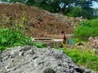
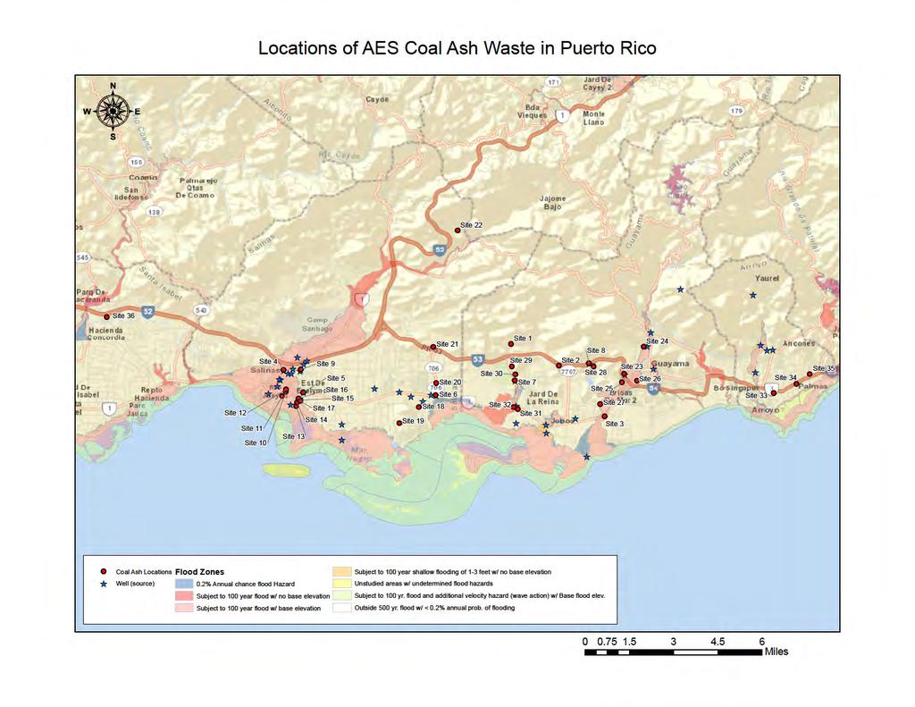
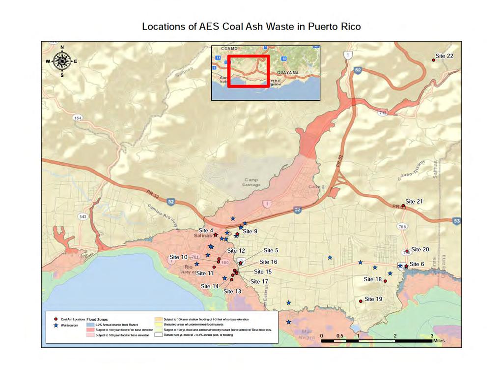
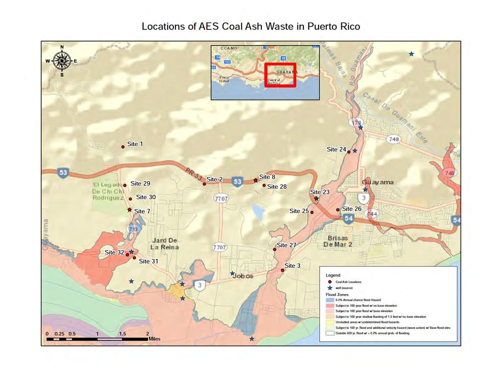
13 Appendix A - Locations and Photographs of AES Coal Ash Waste Disposal Sites in and Around Guayama, Puerto Rico Site 1: Rural Route PR-713 Km 3.3 Cimarrona Ward, Guayama, PR o Latitude/Longitude: , o Sites 1 and 2 are two large adjacent parcels in which AES coal ash is being used to fill or build interior roads to provide access to all parts of the lots. o Note that AES coal ash was poured over unlined soil and is being covered by a thin layer of dirt. Also, some photos show how coal ash was deposited over the Seco River and was washed out by the river. o A Cimarrona community member was interviewed by a local TV reporter (Maritza Cañizares from WAPA) who alleged that several members of the community have been affected by the AES coal ash dust generated by the project and stated that respiratory illness among residents has increased considerably. Site 2: Rural Route PR-7707 Km 3.1 Pozo Hondo Ward, Guayama, PR o Latitude/Longitude: , Site 3: Rural Route PR-3 Km 142 Pozo Hondo and Jobos Ward, Guayama, PR o Latitude/Longitude: , o Site 3 consists of construction of a new bridge over the Guamaní River to replace an existing old one using AES coal ash as base fill over which a section of approximately 200 meters of State Road PR-3 will be built after the bridge in order to improve the existing sharp turn. This project is being built by the Puerto Rico Roads Authority (Autoridad de Carreteras de Puerto Rico). o This project has no construction sign as required by local regulation. Site 4 o Latitude/Longitude: , Site 5 o Latitude/Longitude: , Site 6 o Latitude/Longitude: , Site 7 o Latitude/Longitude: , Site 8 o Latitude/Longitude: , Site 9: Urb. Parque Gabriela II, Route 1, intersection Route 180 o North of Coco III public supply water well. o Latitude/Longitude: , o Lambert Coordinates: x ,y Site 10: Porto Fino Plaza, Route 3 Km o Estimated lat/long: ,
14 Site 11: Porto Bello, PR 180, Intersection Manuel Gonzalez Road o Close to La Margarita public supply water well. o JPU Lambert X , Lambert Y o Estimated lat/long: , Site 12: Arboleda Shopping Court o Estimated lat/long: , Site 13: Urb. Marbella, Matabuey (Julio Llera Morales) Road, Route 3, Km o Just north of many domestic water wells. o Lambert Coordinates: x , y o Estimated lat/long: , Site 14: Urb. Valles de Salinas, Matabuey (Julio Llera Morales) Road, Route 3 Km o x , y o Estimated lat/long: , Site 15: Urb. Vistas de Salinas, Matabuey (Julio Llera Morales) Road, Route 3 Km o , o Lambert Coordinates: x , y Site 16: Urb. Brisas de Evelymar, Matabuey (Julio Llera Morales) Road, Route 3 Km o x , y o Estimated lat/long: , Site 17: Matabuey (Julio Llera Morales) Road, between Route 3 and Villa Sol Street o Estimated lat/long: , Site 18: Route 705, intersection Route 3, Aguirre Sector o Estimated lat/long: , Site 19: Salinas Municipal Landfill, Route 703 o Estimated lat/long: , Site 20: Access Road, parallel to Route 706 between Routes 3 and 53 o North of San Felipe pubic supply water well. o Estimated lat/long: , Site 21: Santa Paula Oil project site, Route 706, intersection Route 53 o Estimated lat/long: , Site 22: Route 706, Ranchos Guayama Sector, between Route 53 north to community exit o Estimated lat/long: , Site 23: Los Recreos Plaza, Route 53, km 138 and access road up to Route 15 o , Site 24: Urb.Estancias de Dulces Suenos, access through Route 53, km 138 o Sinking, mostly abandoned, built on wetlands.
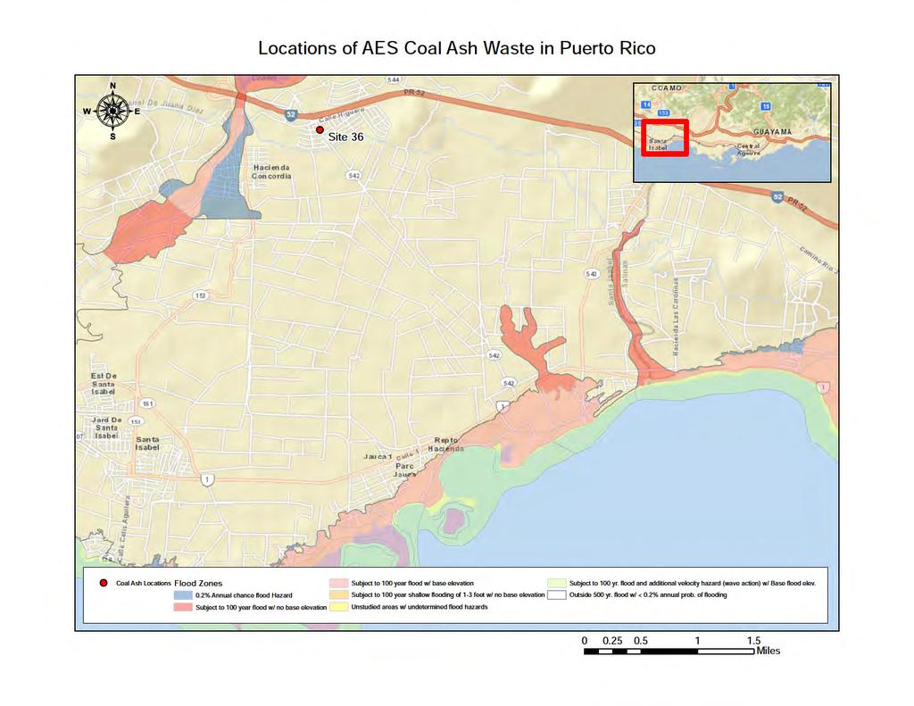
15 o Lambert: x , y o Estimated lat/long: , Site 25: Urb. Ext. Los Recreos, Route 53 km and Pozo Hondo Road o Estimated lat/long: , Site 26: Arpe Building, Los Paseos Road, close to Route 54(53) (Angel Figueroa Bldg.) o Estimated lat/long: , Site 27: AES well field site, Melania Road, intersection Route 3, between km and Km in Bo. Machete (Ward) o Close to Guamani River o Estimated lat/long: , Site 28: Pozo Hondo Road including access to Guayama Landfill o Estimated lat/long: , Site 29: Route 713, between Routes 3 and 53, Villodas Sector o Estimated lat/long: , Site 30: Urb. Mar del Caribe, Route 713 o Close to Seco River o Estimated lat/long: , Site 31: Cora Colony access road, south of Route 3,Km_ o Estimated lat/long: , Site 32: Cemex access road, south of Route 3,Km_ o Estimated lat/long: , Site 33: Arroyo Town Center, Route 3, km , Cuatro Calles Ward o Near 3 public supply water wells o Lambert Coordinates x , y o Estimated lat/long: , Site 34: Eta Sigma Alpha Fraternity, Route 3 km 129 o Close to Punta Guilarte Public Beach and adjoining lot o Near 3 public supply water wells o Estimated lat/long: , Site 35: Route 3, km o Near 3 public supply water wells o Estimated lat/long: , Site 36: Cayure Sector Road, access through Urb. Villa Serena o Estimated lat/long: ,


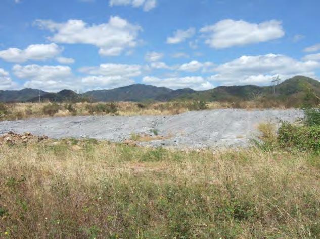
16 Photographs of Disposal Sites Site 1 Figure 1.1 Portion of the road showing how the AES coal ash is covered with a thin layer of dirt. Figure 1.2 New section of the road built with AES coal ash. Figure 1.3 AES coal ash poured across the Seco River and washed out by the river


17 Figure 1.4 A section of the river on the north side of the road showing AES coal ash in the water. Figure 1.5 The portion of the Seco River to the south of the road containg AES coal ash. Site 2 Figure 2.1 Road section with exposed AES coal ash


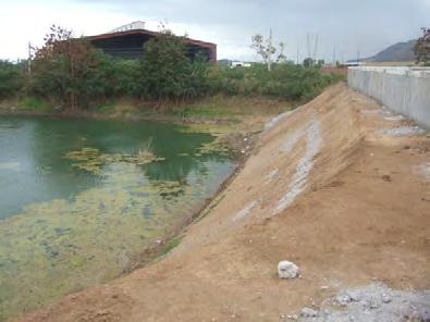
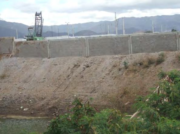
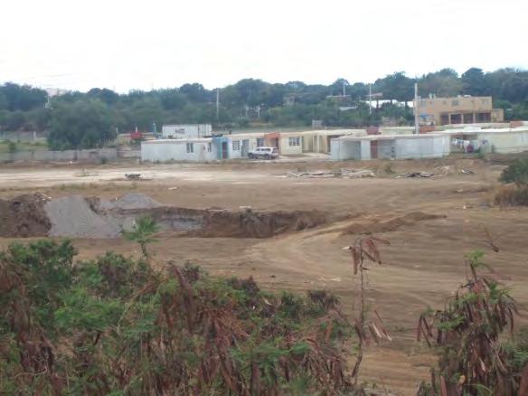
18 Figure 2.2 Residues of AES coal ash spilled on the side of the road. Figure 2.3 A finished section of the road built with AES coal ash. Site 3 Figure 3.1 Partial view of the bridge built over the Guamaní River south to north with AES coal ash visible in the riverbed.


19 Figure 3.2 AES coal ash used as base fill. Figure 3.3 A layer of concrete dust poured over the AES coal ash Figure 3.4 AES coal ash residues drain into the stormwater system


20 Figure 3.5 View of the storm culvert Figure 3.6 Outlet of the storm culvert
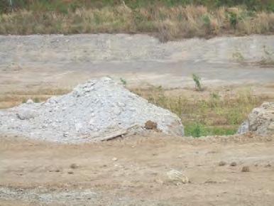

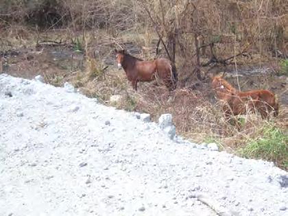
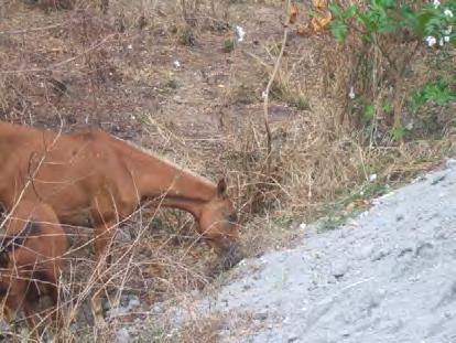
21 Photographs of Other Coal Ash Disposal Sites:

22
23 APPENDIX B MAPS SHOWING COAL ASH DISPOSAL LOCATIONS
24
25
26
27

28
LIHTC Properties in Puerto Rico through 2015
 LIHTC Properties in Puerto Rico through 2015 nprofit PIS ALAMEDA II 4 CARR 21 SAN JUAN PR 1988 t Indicated 1988 Acquisition and Rehab 150 150 ALAMEDA TOWER III SAN JUAN PR 1989 $533,862 1989 Acquisition
FOR SALE >> VACANT LAND. Albuquerque, PRESENTED BY: COLLIERS INTERNATIONAL TOM FRANCHINI, CCIM BILL ROBERTSON
 FOR SALE >> WEST FOR SALE >> MESA Albuquerque, West Mesa NM Vacant Land PRESENTED BY: BILL ROBERTSON LIC. #8433 SENIOR VICE PRESIDENT PRINCIPAL DIR +1 505 880 7050 CELL +1 505 263 6644 BILL.ROBERTSON@COLLIERS.COM
Simple practices to improve and optimize on site wastewater disposal systems (OSDS) in Special Communities of Río Grande de Añasco Watershed
 in Special Communities of Río Grande de Añasco Watershed") Simple practices to improve and optimize on site wastewater disposal systems (OSDS) in Special Communities of Río Grande de Añasco Watershed UNIVERSITY OF PUERTO RICO Mayagüez Campus Ana Navarro, Sea Grant
Simple practices to improve and optimize on site wastewater disposal systems (OSDS) in Special Communities of Río Grande de Añasco Watershed UNIVERSITY OF PUERTO RICO Mayagüez Campus Ana Navarro, Sea Grant
Puerto Rico Public Housing Administration
 Annual Statement / Performance and Evaluation Report Capital Fund Program, Capital Fund Program Replacement Housing Factor and Capital Fund Financing Program HA Name: Grant Type and : FFY of Grant : Puerto
Geographic Response Plan Map: PR-63. B56 - PUERTO DE JOBOS Puerto de MARINA Jobos ! ( de Aguirre. k d A55 - PUNTA. Caribbean Sea
 Geographic Response Plan Map: PR-63 66 7'30W 18 0'0N 18 0'0N 66 15'0W 52 53 Guayama Salinas Bay National Estuary Research Resere NOAA) A53 MAR NEGRO PREPA Aguirre B56 - PUERTO DE JOBOS Puerto e MARINA
ARTICLE 7 MOBILE HOME AND RECREATIONAL VEHICLE PARKS AND CAMPGROUNDS
 ARTICLE 7 MOBILE HOME AND RECREATIONAL VEHICLE PARKS AND CAMPGROUNDS Section 701. APPLICABILITY Where a municipality has no subdivision or land development ordinance the provisions of this article shall
01T_ODD2_DCH 01T_ODD3_ARN
 01T_ODD2_DCH Duck Pond Agricultural Drains / Mugu Drain / Oxnard Drain No. 2. The monitoring site is located on an agricultural drain just south of Hueneme Road near the Duck Ponds. Flow from this drain
SUBJECT: State Contract No.: N06009S; Schnabel Project No.: NONCD , Stanfield Dump, Letter Report
 11-A Oak Branch Drive Greensboro, NC 27407 December 4, 2009 Phone: (336) 274-9456 Fax: (336-274-9486 www.schnabel-eng.com Mr. Bruce Lefler NCDENR, Division of Waste Management 1646 Mail Service Center
CANOVANAS URBAN DEVELOPMENT CORP. P.O. BOX SAN JUAN, P.R
 CANOVANAS URBAN DEVELOPMENT CORP. P.O. BOX 9021990 SAN JUAN, P.R. 00902-1990 787-602-8955 proyectosnuevospr@gmail.com COMMERCIAL LOTS FOR SALE UP TO 60,000 S.F. AVAILABLE FOR CONSTRUCTION Karla Mas O Neill
VI. ALTERNATIVES TO THE MASTER PLAN C. RENOVATED EAST BUILDING ALTERNATIVE
 VI. ALTERNATIVES TO THE MASTER PLAN C. RENOVATED EAST BUILDING ALTERNATIVE INTRODUCTION The Renovated East Building Alternative would include the continued use of the renovated West Building and the renovation
NPDES PII Small MS4 General Permit Annual Report (Due: November 6, 2012)
") Municipality/Organization: Municipality of Aibonito EPA NPDES Permit Number: PRR040041 Annual Report Number Year 4 (2012) & Reporting Period: November 1, 2011 October 31, 2012 NPDES PII Small MS4 General
Municipality/Organization: Municipality of Aibonito EPA NPDES Permit Number: PRR040041 Annual Report Number Year 4 (2012) & Reporting Period: November 1, 2011 October 31, 2012 NPDES PII Small MS4 General
PLAT MAP COMPARABLE SALES. Meadows Rd. Mountain ESCONDIDO
 AERIAL MAPS PROJECT INFORMATION PURCHASE PRICE: $575,000 TO RIVERSIDE Meadow Glen Way East Cougar Pass Rd N SITE Old Hwy 395 Hidden Meadows Rd Cougar Pass Rd Mountain Meadows Rd ESCONDIDO Deer Springs
VILLA MARGARITA PUENTE ROMANO - SPAIN, MARBELLA AREA
 VILLA MARGARITA PUENTE ROMANO - SPAIN, MARBELLA AREA 6 GUESTS, 3 BEDROOMS VILLA MARGARITA PUENTE ROMANO Spain, Marbella Area 6 Guests 3 Bedrooms SUMMARY Six Senses Spa resort 400 sqm private garden 150
FACT SHEET HUNTERS POINT SHIPYARD Parcel E-2 PCB Hot Spot Time-Critical Removal Action: 2010
 FACT SHEET HUNTERS POINT SHIPYARD Parcel E-2 PCB Hot Spot Time-Critical Removal Action: 2010 Shoreline Hot Spot Area Central Portion - View North October 2009 This fact sheet provides information about
United States Department of the Interior National Park Service. Boundary Expansion Listed in National Register January 11, 2017
 NPS Form 10900-a (Rev. 8/2002) OMB No. 10240018 United States Department of the Interior National Park Service Boundary Expansion Listed in National Register January 11, 2017 National Register of Historic
Photographic Log Client: Project Number: Site Location: Site Name: Photograph ID: Date: Location: Direction: Comments: Photograph ID:
 Photograph ID: 1 west View of one of the monitoring well and the large parking lot on the south side of Center Street. Photograph ID: 2 Monitoring well located in the middle of the parking lot located
NORTH COUNTY CORPORATE CENTER
 NORTH COUNTY FOR CORPORATE LEASE > CLASS CENTER"A" OFFICE SPACE WITH NEW COMMON AREA FINISHES 277 RANCHEROS DRIVE, CA 92069, The Building BRAND NEW GROUND FLOOR LOBBY SPEC SUITE AND COMMON AREA FINISHES
RIO VISTA MUNICIPAL AIRPORT
 DRAINAGE TECHNICAL MEMORANDUM RIO VISTA MUNICIPAL AIRPORT RIO VISTA, CALIFORNIA Prepared for: City of Rio Vista 1 Main Street Rio Vista, CA 94571 (707) 374-5337 Prepared by: August 2012 Copyright 2012
(No. 9) (Approved April 8, 2001) AN ACT
 (Approved April 8, 2001) AN ACT") (S. B. 148) (No. 9) (Approved April 8, 2001) AN ACT To establish the Puerto Rico National Parks System, establish its objectives, its administration, the powers and duties of the Executive Director of
(S. B. 148) (No. 9) (Approved April 8, 2001) AN ACT To establish the Puerto Rico National Parks System, establish its objectives, its administration, the powers and duties of the Executive Director of
155 acres on Tyaughton Lake 900 feet of Pristine Waterfront Private & Secluded Property
 155 acres on Tyaughton Lake 900 feet of Pristine Waterfront Private & Secluded Property 946 Tyaughton Lake Road Gold Bridge BC V0K1P0 900 ft of waterfront with 155 acres of south facing easy access. This
ADEQ - Water Division Spill/Incident Report
 ADEQ - Water Division Spill/Incident Report ADEQ Incident #: 14-0135 NRC #: County: Pulaski PDS # 016774 Date and Time of Incident: 03/07/2014 @ 23:00 Date & Time Reported: 03/08/2014 @ 07:09 Responsible
Reference Number. Station
 Table A.7 Population and Number of Households within 800m Radius of Proposed s ALTERNATIVE 1 ALTERNATIVE 2 ALTERNATIVE 3 Reference Number Population Households Reference Number Population Households Population
List of Environmental Reports and Documents Regarding Hazardous Materials. August 10, 2017
 List of Environmental Reports and Documents Regarding Hazardous Materials August 10, 2017 Pier 70 1999 Annual Ground Water Monitoring Report for Piers 70 and 94, Tetra Tech, Inc., February 2000. 1999 Annual
Monday 14 th December 2015 A Christmas with Shows
 Monday 14 th December 2015 Theatre showcase by the Municipal School: "Navidad en el fondo del mar" (Christmas under the sea) and "Las pequeñas y grandes emociones de la vida" (life's small and big thrills)
Plaza Business Park Hotel, Office, and Restaurant Sites
 Plaza Business Park Hotel, Office, and Restaurant Sites The Plaza Business Park is designed A 115-room hotel, a 3,500-7,500 SF fast food restaurant sites with drive to accommodate the following: restaurant,
NATIONWIDE PERMIT ACTIONS APR - JUN DA Number Action Type Project Name End Date Closure Method County State
 SPA-2008-00427-S Clear Creek ranch - stream restoration/enhancement -Clear Creek, Chaffee Co., 12-Jun-13 Chaffee SPA-2013-00127 Arkansas River Bank Stabilization Project at 352 and 354 East Sacket Avenue
Propiedades Selectas Prime Properties Geselecteerd Vastgoed. Ref.: EXCLUSIVELY FOR SALE WITH COSTAS & CASAS.
 Propiedades Selectas Prime Properties Geselecteerd Vastgoed 1 Villa Ref.: 111163 - EXCLUSIVELY FOR SALE WITH COSTAS & CASAS Marbella First Line Beach Costa del Sol A life in the sun This sunny coast, washed
Yucca Mountain Nuclear Fuel Locations and Associated Rail Facilities. Rancho Seco Nuclear Generating Station, California
 Yucca Mountain Nuclear Fuel Locations and Associated Rail Facilities Rancho Seco Nuclear Generating Station, California Yucca Mountain: Nuclear Fuel Locations and Associated Rail Facilities October 1,
Griffith Park Trail Run Trail Guide Click for
 The Griffith Park Trail Run by Hike- LosAngeles.com Griffith Park Trail Run Trail Guide Click for downloadable cell phone guide and map from EveryTrail. DISTANCE: 4.55 Miles ELEVATION: 1280' ELEVATION
The 710 Tunnel Threatens Pasadena. March, 2013
 The 710 Tunnel Threatens Pasadena March, 2013 Metro Route 710 Study Metro Route 710 Study Metro Study Alternatives Bus Rapid Transit (BRT-6) Light Rail (LRT-4) Metro Study Alternatives Bus Service Transportation
This is an official document, if any discrepancies found in the content please contact Gran Vision Design team. T A Carretera
 I believe art is sacred. Our spiritual interpretation of nature. Art is sound and taste. Art is learning from the past but staying in the present. Art is freedom and simplicity is art. That is what we
Mr. Michael Malone CPS Energy 145 Navarro Street San Antonio, Texas Project No
 January 15, 2016 Mr. Michael Malone 145 Navarro Street San Antonio, Texas 78205 Project No. 0328985 Environmental Resources Management CityCentre Four 840 West Sam Houston Pkwy N. Suite 600 Houston, Texas
ANNUAL Highlights
 22 23 Forestry Business Arauco and Stora Enso inaugurate Arauco receives the environmental 01 the Montes del Plata wood pulp 02 approval of the Arauco Mill 03 mill in Uruguay. This facility Modernization
SITE SUMMARY REPORT Troy Landfill NONCD Montgomery County
 SITE SUMMARY REPORT Troy Landfill NONCD 0000436 Montgomery County Senate Bill 1492 State of North Carolina State Contract N06009S Schnabel Project No. 06210002.23 March 8, 2010 Prepared for: North Carolina
Public-Private Partnerships. Mr. David Alvarez Executive Director Puerto Rico Public-Private Partnerships Authority March 29, 2011
 Public-Private Partnerships Mr. David Alvarez Executive Director Puerto Rico Public-Private Partnerships Authority March 29, 2011 Disclaimer Today s presentation includes certain statements that are not
Welcome KROSNO CREEK DIVERSION PROJECT CLASS ENVIRONMENTAL ASSESSMENT
 Welcome KROSNO CREEK DIVERSION PROJECT PUBLIC INFORMATION CENTRE # 1 Tonight s Presentation Study Overview Background Existing Conditions Alternative Solutions Preliminary Preferred Solution Next Steps
UNIVERSITY OF ILLINOIS URBANA ACES
 UNIVERSITY OF ILLINOIS URBANA ACES Discover Cuba March 18 th 24 th 2017 This well rounded itinerary showcases the culture, history and beauty of Cuba. It is designed to introduce you to Cuba beyond the
Below is the section of the Byway discussed in the Tazewell County meeting. Primary coal sites are noted on the map.
 APPENDIX H: PUBLIC PARTICIPATION SERIES OF TOWN MEETINGS Virginia Coal Heritage Trail Corridor Management Plan Meeting in Richlands on the Tazewell County portion of the Pocahontas Trail September 21 st
Section 61 Recreational Vehicle Park / Campground (Bylaw No. 2012/10)
") Part 7 General Regulations Section 61 Recreational Vehicle Park / Campground (Bylaw No. 2012/10) 61.1 A comprehensive site plan shall be provided to the satisfaction of the Development Authority that shows
Part 7 General Regulations Section 61 Recreational Vehicle Park / Campground (Bylaw No. 2012/10) 61.1 A comprehensive site plan shall be provided to the satisfaction of the Development Authority that shows
NATIONWIDE PERMIT ACTIONS APRIL - JUNE 2014
 DA Number 00385-LCO 00123 00124 00073 00075 00430 00043-SCO 00062-SCO 00062-SCO 00183-SCO 00195-SCO 00264-SCO 00272-SCO 00278-SCO 00282-SCO Action Type Name Closure Method County State Kingston Road and
COMMUNITY PLANNING ACTION REFLECTION G-8. Private, Non-Profit
 Encuentro de líderes comunitarios 12 de junio de 2014 COMMUNITY PLANNING ACTION REFLECTION ENLACE Quasi government 20 years Mission: Implement the Integrated Development Plan and Land Use for Special Planning
The rezoning application is recommended for consideration of approval.
 Date: November 26, 2012 To: From: Chairperson and Members Planning and Housing Committee Ken O Brien, MCIP Manager of Planning & Information Cliff Johnston, MCIP Director of Planning Re: Department of
Appendix C. Tenderfoot Mountain Trail System. Road and Trail Rehabilitation Plan
 Appendix C Tenderfoot Mountain Trail System Road and Trail Rehabilitation Plan All rehabilitation work would be under the direction of the District Fisheries Biologist, the Forest Hydrologist, and/or the
CAPTIVATING COSTA RICA
 CAPTIVATING COSTA RICA Costa Rica LONDON OFFICE +44 (0)20 7022 6560 NEW YORK OFFICE +1 (212) 370-8468 HONG KONG OFFICE +852 3752 2076 DUBAI OFFICE +971 4 437 6802 SINGAPORE OFFICE +65 6511 1190 INDIA OFFICE
Agenda Report. Spruce Street Outlet Drainage Improvements Tower Road Relief Sewer
 Agenda Report Subject: Prepared By: Spruce Street Outlet Drainage Improvements Tower Road Relief Sewer Steven M. Saunders, Director of Public Works/Village Engineer Date: August 12, 2012 On March 8, 2012
START / FINISH Irvine Valley College. 100 Mile Course Map
 START / FINISH Irvine Valley College 100 Mile Course Map ELEVATION MAP 100 MILE COURSE 100Mile Total Dist Direction / Street Name 0 Start at Irvine Valley College 0.2 Right onto Jeffrey Road 3.7 Left on
Valle Central LA SERENA HERE IDETAIL THE REGULAR TOURS THAT WE MAKE EVERY DAY
 Valle Central LA SERENA HERE IDETAIL THE REGULAR TOURS THAT WE MAKE EVERY DAY TOUR NATIONAL RESERVE DAMAS ISLAND TOUR - HUMBOLDT PENGUIN NATIONAL RESERVE First, we move to Punta de Choros cove, which is
±8,000 SF OFFICE/WAREHOUSE 2545 WEST CHEYENNE AVENUE, NORTH LAS VEGAS NV >> INDUSTRIAL SPACE FOR LEASE OR SALE
 ±8,000 SF OFFICE/WAREHOUSE 2545 WEST CHEYENNE AVENUE, NORTH LAS VEGAS NV 89032 >> INDUSTRIAL SPACE FOR LEASE OR SALE PROPERTY DESCRIPTION PROPERTY FEATURES 2545 West Cheyenne Avenue in North Las Vegas
CariCOOS/WxFlow Wind Measurements during Hurricane Irene over the U.S. Virgin Islands and Puerto Rico
 over the U.. Virgin Islands and Puerto Rico August 21-22, 211 For more information about wind observations contact: Luis D. Aponte-Bermúdez, Ph.D., P. -mail: luisd.aponte@upr.edu or visit: http://www.caricoos.org/
Cubahavanatours.com Cuba Nature Tour 8 Days/ 7 Nights
 The following is a Itinerary pricing/proposal for your travel to Cuba, The rate listed below is for 4 participants based on Double occupancy. There is a single occupancy supplement of $375.00. In the event
NATIONWIDE PERMIT ACTIONS JULY - SEPTEMBER Action Type Project Name Closure Method County State SPA SCO NWP River West Development
 DA Number Action Type Project Name Closure Method County State SPA-2013-00282- River West Development Chaffee CO SPA-2010-00457 Delbert Smith Conejos CO SPA-2010-00457 Delbert Smith Conejos CO SPA-2013-00379
David Magney Environmental Consulting
 David Magney Environmental Consulting DELINEATION OF JURISDICTIONAL WATERS AND RIPARIAN HABITATS FOR LYONS CANYON RANCH, NEWHALL, CALIFORNIA Prepared for: UNITED STATES ARMY CORPS OF ENGINEERS and CALIFORNIA
APPENDIX F List of Commitments
 APPENDIX F List of Commitments s Table F.1 Standard Mitigation Measures Mitigation Measure MnDOT Specification Number Status Update Description Status Update Utilities Provide early notice to utility operators
Flood History. Floodplain Descriptions
 Flood History The worst flooding in the area took place in 1966, 1969, 1971, 1995 and 1998. The storms in 1966 and 1969 caused considerable damage throughout the area due to flooding, erosion and debris
exclusive villas private residential estate
 exclusive villas private residential estate A getaway that s not miles away Located in a privileged position with spectacular views across the Mediterranean coastline. Benahavís Hills is only a stone s
INLAND STEEL COMPANY, INDIANA HARBOR WORKS PHOTOGRAPHS,
 Collection # P 0711 INLAND STEEL COMPANY, INDIANA HARBOR WORKS PHOTOGRAPHS, 1926 Collection Information 1 Historical Sketch 2 Scope and Content Note 3 Contents 4 Processed by Dalton Gackle July 2018 Manuscript
An Overview of the Puerto Rico Technology Transfer Center: A Local Technical Assistance Program Component
 Second LACCEI International Latin American and Caribbean Conference for Engineering and Technology (LACCEI 2004) Challenge and Opportunities for Engineering Education, Research and Development 2-4 June
JHSF Participações S.A. November 2016
 JHSF Participações S.A. November 2016 DISCLAIMER Management makes forward-looking statements concerning future events that are subject to risks and uncertainties. These statements are based on its beliefs
Town of Oakfield Agricultural and Farmland Protection Plan
 SECTION III COMMUNITY OVERVIEW A. Regional Setting / Location The Town of Oakfield is located in the northwestern portion of Genesee County. Located west of New York's Finger Lakes, the Town is uniquely
Use this option if you plan to arrive to the Rose Bowl anytime after 10:00 am
 Option 1 Public Transportation to the Rose Bowl Game with Free Shuttle option Use this option if you plan to arrive to the Rose Bowl anytime after 10:00 am Free Shuttle Information and Hours: On January
EugenioFernándeIAz, AP.O. Box 3423, Guaynabo, PR 00970
 EugenioFernándeIAz, AP.O. Box 3423, Guaynabo, PR 00970 39 Englewood Ave. Apt. 20 Brighton, MA 02135 Tel: 787-751-0440 Mobile: 787-536-7003 E Mail: efegroup@coqui.net! efernandez@efearchitects.com SUMMARY
RACER Properties in Saginaw Area
 RACER Properties in Saginaw Area Bruce Rasher, Redevelopment Manager brasher@racertrust.org Saginaw Area, MI Overview See Buena Vista Township View map for details See Saginaw View map for details 2017
Service Sector: Puerto Rico as a Knowledge-Exporting Economy. Javier Vázquez-Morales, Esq. Puerto Rico Industrial Development Company
 Service Sector: Puerto Rico as a Knowledge-Exporting Economy Javier Vázquez-Morales, Esq. Puerto Rico Industrial Development Company Manufacturing: Key Component of Puerto Rico s Economy for Decades Puerto
$2.00/SF BROKER BONUS
 $2.00/SF BROKER BONUS FOR ANY LEASES SIGNED BY NOVEMBER 1 ST, 2017 12625 HIGH BLUFF DRIVE SAN DIEGO, CA 92130 Unique Spanish Colonial-styled architecture building in Del Mar Heights Open-air courtyard
Architectural Analysis in Western Palenque
 Architectural Analysis in Western Palenque James Eckhardt and Heather Hurst During the 1999 season of the Palenque Mapping Project the team mapped the western portion of the site of Palenque. This paper
MORGAN CREEK GREENWAY Final Report APPENDICES
 APPENDICES MORGAN CREEK GREENWAY Appendix A Photos of Existing Conditions in Trail Corridor Photos of existing conditions Main trail corridor - February 2009 Photos of existing conditions south bank Morgan
Hospital Link Project Project Update Winter 2018
 Hospital Link Project Project Update Winter 2018 General The project provides a link from Riverside Drive and the Transitway to the Hospital Link Road. Construction of the Hospital Link facility is open
SAHARA RANCHO CORPORATE CENTER SOUTH RANCHO DRIVE LAS VEGAS, NV 89102
 Sahara Rancho Corporate Center is adjacent to I-5 located at the intersection of Sahara Avenue and Rancho Drive with close proximity to the Las Vegas Strip, McCarran International Airport and Downtown.
UNIVERSIDAD DEL SAGRADO CORAZÓN DEPARTMENT OF NATURAL SCIENCES
 UNIVERSIDAD DEL SAGRADO CORAZÓN DEPARTMENT OF NATURAL SCIENCES TITLE OF THE COURSE: FORESTS OF PUERTO RICO CODE: BIO 220 CREDITS : 3 PRERREQUIREMENT : BIO 109 or BIO 111 CONFERENCE : 45 HOURS DESCRIPTION
Puerto Rico General Distributing Co.
 Puerto Rico General Distributing Co. Spectacular Provision Programs Please allow me to introduce Puerto Rico General Distributing Company and myself Tino Arias, President of PRGD. For the past 27 years
USCA Case # Document # Filed: 07/17/2014 Page 1 of 5. Petitioners, PETITION FOR REVIEW
 - --- USCA Case #14-1138 Document #1503791 Filed: 07/17/2014 Page 1 of 5 v. Petitioners, and GINA MCCARTHY, ADMINISTRATOR OF THE PETITION FOR REVIEW Pursuant to the Clean Air Act, 307(b (1, 42 U.S.C. 7607(b
Welcome Land Use Element... LU-1
 Welcome Land Use Element... LU-1 Land Use Plan... LU-3 Residential Land Uses... LU-12 Commercial Land Uses... LU-14 Mixed Use... LU-16 Industrial Land Uses... LU-18 Automobile-Related Land Uses... LU-19
One Country-Two Coasts Caribbean & Pacific Beaches 11 Days / 10 Nights
 One Country-Two Coasts Caribbean & Pacific Beaches 11 Days / 10 Nights ITINERARY OVERVIEW Day 1: Arrival to San Jose & private transfer to Manuel Antonio Beach. Day 2: Free day to relax at Manuel Antonio
Performing Hand Hygiene Using an Alcohol-Based Handrub
 1 Skill 1-1 Performing Hand Hygiene Using an Alcohol-Based Handrub Goal: Transient microorganisms are eliminated from the hands. 1. Remove jewelry, if possible, and secure in a safe place. A plain wedding
Unincorporated Quartz Hill -Lancaster- Palmdale STUDY AREA PROFILE
 Unincorporated Quartz Hill -Lancaster- Palmdale STUDY AREA PROFILE STUDY AREA ID #19 BASE MAP PARK METRICS WHERE ARE PARKS MOST NEEDED AMENITY QUANTITIES AND CONDITIONS PARK NEEDS FRAMEWORK PROJECT COST
EAST VALLEY PARKWAY FOR SALE - RESIDENTIAL DEVELOPMENT OPPORTUNITY 3141 E. VALLEY PARKWAY ESCONDIDO, CA ACRE SITE $1,100,000
 3141 E. VALLEY PARKWAY ESCONDIDO, CA 92027-5219 3.31 ACRE SITE $1,100,000 OFFERING HIGHLIGHTS Valley High School Residential Development Opportunity Close to Frances Ryan Park & Multiple Schools Settled
Supporting Neighborhood Council Elections in your Neighborhood. Office of the City Clerk
 Region A: Canoga Park, Chatsworth, Granada Hills North, Granada Hills South, North Hills West, Northridge East, Northridge West, Porter Ranch, West Hills, Winnetka, Woodl Hills-Warner Center Monday, December
12,610 SF CREATIVE OFFICE FOR LEASE W ELMYRA ST LOS ANGELES, CA LA HISTORIC PARK N SP LOCAL EXPERTISE. INTERNATIONAL REACH. WORLD CLASS.
 W ELM MYRA ST LA HISTORIC PARK N SP RING NG ST LLEW EWEL ELLY LY LYN ST LOCAL EXPERTISE. INTERNATIONAL REACH. WORLD CLASS. 12,610 SF CREATIVE OFFICE FOR LEASE 130 W ELMYRA ST LOS ANGELES, CA 90012 TEAM-CLINE.COM
THE ALBERTA GAZETTE, SEPTEMBER
 VILLAGE OF CEREAL Order No. 16915 IN THE MATTER OF THE "Municipal Government Act": File No. 241(A)3 AND IN THE MATTER OF an application by the Council of the Village of Cereal, in the Province of Alberta,
Villa la Reserva Region: Costa del Sol Sleeps: 6
 Villa la Reserva Region: Costa del Sol Sleeps: 6 Overview Located in the exclusive gated community of Cortijos de la Reserva, on the Western end of the Costa Del Sol, Villa La Reserva is the perfect getaway
South America Trekking Trip November 13 - December 1, 2018
 South America Trekking Trip November 13 - December 1, 2018 Trip Leader: Isabel Bravo Come with us to explore South America covering the metropolitan capitals and some of the world s most beautiful and
Modern Luxury Design Villas in a Gated Community
 Modern Luxury Design Villas in a Gated Community La Cala Views is a new development located in the exclusive and much sought after area of La Cala de Mijas (Mijas Bay). It is a gated community with a remotely
AGRICULTURAL LAND ±197 AC HENRY MILLER RD, LOS BANOS, CA 93635
 Turner Island Rd, MERCED COUNTY Santa Fe Grade SITE CONTACT US RANDY GRIMSMAN Senior Vice President +1 916 446 8745 randall.grimsman@cbre.com www.cbre.com/randall.grimsman Lic. 00857338 CBRE, Inc. 500
Potato Chip Grinder. Sheet1
 Potato Chip Grinder MILE DIRECTIONS FOR 0 START: Albertsons 5 Woodland Pkwy San Marcos, CA. (OPEN:00:00 CLOSE:+0:00) Obtain proof of start from local business with time & date stamp. Exit parking lot toward
México-Monterrey. Aida Carolina Medina Gómez LNI
 México-Monterrey Aida Carolina Medina Gómez 685549 LNI Monterrey: Monterrey is the capital city of the northeastern Mexican state of Nuevo León. It has the second largest metropolitan area according to
LESLIE BARNS & CONNECTION TRACK. Construction Liaison Group Meeting #6 January 30, 2014
 LESLIE BARNS & CONNECTION TRACK Construction Liaison Group Meeting #6 January 30, 2014 Construction Liaison Group Jan 30 2014 1 OVERVIEW HAPPY BELATED NEW YEAR Works to Date Underground Utilities Bell
Analysis of Indicator Bacteria in NJ Dead-end Lagoons. Michael Callaghan Gasbarro Mentor: Dr. Kathryn Goddard
 Analysis of Indicator Bacteria in NJ Dead-end Lagoons Michael Callaghan Gasbarro Mentor: Dr. Kathryn Goddard Delaware Valley Estuary Summit Session 20: January 28, 2015 Dead-end Canals or Lagoons Popular
promotion early Win your trip for free! Book ANY South package by September 30 with a deposit of $100, and get: Our Price Drop Guarantee
 Win your trip for free! early promotion for travel between december 15, 2016 and April 30, 2017 Book ANY South package by September 30 with a deposit of $100, and get: The option to change your travel
SUPER EARLY BOOKING PROMOTION For bookings made by June 30, for travel between November 1, 2017, and April 30, 2018
 SUPER EARLY BOOKING PROMOTION For bookings made by June 30, for travel between November 1, 2017, and April 30, 2018 Book a South package and get these advantages: Our Price Drop Guarantee The option to
DRAFT. Dorabelle Campground Rehabilitation
 DRAFT Dorabelle Campground Rehabilitation September 2012 1.1 REGIONAL SETTING AND PROJECT LOCATION The Dorabelle Campground is located on the western shore of Shaver Lake in Fresno County, California (Section
Modern Luxury Villas with Panoramic Sea View
 Modern Luxury Villas with Panoramic Sea View Retamar Santa Matilde is a unique development next to the exclusive area of Benalmádena Pueblo. The location provides panoramic views of the coast and the Mediterranean
All bidders should use the new Right-of-Way Landscape Maintenance Services Project / Areas ( Revised Attachment B below)
") ADDENDUM TO RFP #8-0 DOCUMENTS REQUEST FOR BID: RFP #8-0 Right-of-Way Landscape Maintenance Services ADDENDUM NO. DATE: May 7, 07 To All Prospective Bidders: This addendum is issued to modify the previously
ADDENDUM TO RFP #8-0 DOCUMENTS REQUEST FOR BID: RFP #8-0 Right-of-Way Landscape Maintenance Services ADDENDUM NO. DATE: May 7, 07 To All Prospective Bidders: This addendum is issued to modify the previously
Williamson Rock/Pacific Crest National Scenic Trail (PCT) Project EIS. Notice of intent to prepare an Environmental Impact Statement.
 Project EIS. Notice of intent to prepare an Environmental Impact Statement.") [3411-15-P] DEPARTMENT OF AGRICULTURE Forest Service Angeles National Forest; Los Angeles County, CA Williamson Rock/Pacific Crest National Scenic Trail (PCT) Project EIS AGENCY: ACTION: Forest Service,
[3411-15-P] DEPARTMENT OF AGRICULTURE Forest Service Angeles National Forest; Los Angeles County, CA Williamson Rock/Pacific Crest National Scenic Trail (PCT) Project EIS AGENCY: ACTION: Forest Service,
Puerto Rico Convention Center August Exhibit Agreement COMPANY NAME: CONTACT PERSON: MAILING ADDRESS:
 COMPANY NAME: CONTACT PERSON: MAILING ADDRESS: CITY: ZIP CODE: TELEPHONE: CELL PHONE: FAX: EMAIL: A 50% nonrefundable deposit will be required upon signing the agreement. Full payment for the booth space
FHWA P/N Guidelines. Corridor Relationship. Highway 22 Segment 1 - US 169 to CSAH 2 Relevance / Documentation of Need
 Highway 22 Segment 1 - US 169 to CSAH 2 Vehicle Mobility Congestion Intersection Congestion Existing Conditions - Based on Highway Capacity Manual methodology, corridor level of service is currently LOS
Sulphur Creek Wetlands Restoration Project in the Valles Caldera National Preserve, Sandoval County, New Mexico
 DA Number Action Type Project Name Closure Method County State SPA-2015-00107-ABQ Sulphur Creek Wetlands Restoration Project in the Valles Caldera National Preserve, Sandoval County, New Mexico Sandoval
THREE MILE PLAN TOWN OF SUPERIOR COLORADO
 THREE MILE PLAN TOWN OF SUPERIOR COLORADO February 23, 2015 INTRODUCTION This document has been prepared by the Town of Superior, Colorado, to address the existing and proposed land uses within an approximate
W I T H 18 Y E A R S OF E X P E R I E N C E IN T H E E D U C A T I O N S E C T O R, E X P L O R E C O L O M B I A IS T H E M O S T I M P O R T A N T
 W I T H 18 Y E A R S OF E X P E R I E N C E IN T H E E D U C A T I O N S E C T O R, E X P L O R E C O L O M B I A IS T H E M O S T I M P O R T A N T C O R P O R A T I O N IN C O L O M B I A S P E C I A
ARCHAEOLOGICAL MONITORING OF THE ASHBY STREET DRAINAGE PROJECT, SAN ANTONIO, BEXAR COUNTY, TEXAS
 ARCHAEOLOGICAL MONITORING OF THE ASHBY STREET DRAINAGE PROJECT, SAN ANTONIO, BEXAR COUNTY, TEXAS Anne A. Fox and I. Waynne Cox / Center for Archaeological Research The University of Texas at San Antonio
Sandbag Barrier. Suitable Applications Sandbag barriers may be suitable: As a linear sediment control measure:
 Categories EC Erosion Control SE Sediment Control TC Tracking Control WE Wind Erosion Control Non-Stormwater NS Management Control Waste Management and WM Materials Pollution Control Legend: Primary Category