Africa s. Presentation, Graphic Organizers, & Activities
|
|
|
- James Freeman
- 5 years ago
- Views:
Transcription

1 Africa s Presentation, Graphic Organizers, & Activities
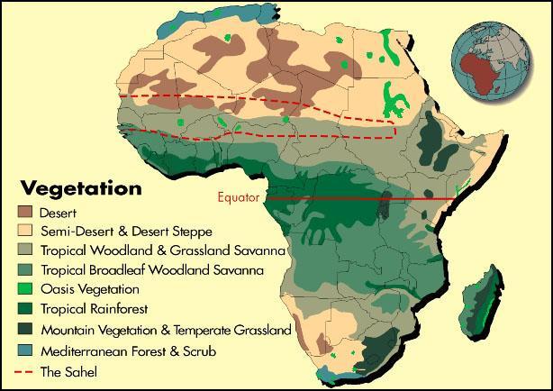
2 STANDARDS: SS7G1 Locate selected features of Africa. a. Locate on a world and regional political-physical map: Sahara, Sahel, savanna, tropical rain forest, Congo River, Niger River, Nile River, Lake Victoria, Great Rift Valley, Mt. Kilimanjaro, Atlas Mountains, and Kalahari Desert. b. Locate on a world and regional political-physical map the countries of Democratic Republic of the Congo, Egypt, Kenya, Nigeria, South Africa, and Sudan
3 TEACHER INFO: Print off the following 2 pages for each student. (Print front-to-back to save paper.) Students should use an atlas to label the map before the presentation.
4 I. Political Features: Label the following countries on the map: Democratic Republic of the Congo Egypt Kenya Nigeria South Africa Sudan Brain Wrinkles

5 II. Physical Features: Create a map key that includes symbols for: Rivers Deserts Mountains Lakes Sahel Savanna Rainforest Label the following physical features: Sahara Sahel Savanna Tropical rain forest Congo River Niger river Nile River Lake Victoria Great Rift Valley Mt. Kilimanjaro Atlas Mountains Kalahari Desert Map Key Draw the symbol for each feature next to the correct label on the map. Color all symbols! Brain Wrinkles

6 17. Great Rift Valley 19. Atlas Mountains 2. Egypt 8. Sahara 14. Nile River 6. Sudan 13. Niger River 9. Sahel 4. Nigeria 10. Savanna 1. Democratic Republic of the Congo 3. Kenya 12. Congo River 11. Tropical rainforest 16. Lake Victoria 18. Mt. Kilimanjaro Political Map 5. South Africa Physical Map 20 Kalahari Desert
7 TEACHER INFO: Print off the following slide for each student. *Print front-to-back to save paper. They should complete the chart while discussing the presentation. Check answers as a class when finished. If time, have students color their pictures.
8 Africa s Physical Features Directions: Complete the chart below with information that you learn during the presentation. If time allows, color your illustrations. Sahara Sahel What: What: Where: Where: Illustration: Illustration: Savanna Tropical Rain forest What: What: Where: Where: Illustration: Illustration: Congo River Niger River What: What: Where: Where: Illustration: Illustration: Nile River Lake Victoria What: What: Where: Where: Illustration: Illustration: Brain Wrinkles
9 Africa s Physical Features Directions: Complete the chart below with information that you learn during the presentation. If time allows, color your illustrations. Great Rift Valley Mt. Kilimanjaro What: What: Where: Where: Illustration: Illustration: Atlas Mountains Atlas Mountains What: What: Where: Illustration: Where: Illustration: Brain Wrinkles
10 Africa s Physical Features Directions: Complete the chart below with information that you learn during the presentation. If time allows, color your illustrations. Sahara What: world s largest desert Sahel What: transition zone between desert and rainforest; has become more of a desert in recent years Where: northern Africa Illustration: will vary Where: south of Sahara and north of the equator Savanna What: rolling grasslands with scattered trees and shrubs; 4.5 million square miles Illustration: will vary Tropical Rain forest What: 2 nd largest rainforest in the world; 90% has been destroyed because of deforestation Where: cover regions north and south of the rainforests around the equator Illustration: will vary Congo River What: 2 nd longest river in Africa; crosses equator twice Where: central Africa (Democratic Republic of the Congo) Illustration: will vary Niger River What: principle river of west Africa Where: flows through rainforest in west central Africa Where: west Africa Illustration: will vary Illustration: will vary Nile River What: world s longest river Where: flows northward through eastern Africa into the Mediterranean Sea Lake Victoria What: headwaters reservoir for Nile; largest lake in Africa Where: Kenya, Tanzania, Uganda Illustration: will vary Illustration: will vary Brain Wrinkles
11 Africa s Physical Features Directions: Complete the chart below with information that you learn during the presentation. If time allows, color your illustrations. Great Rift Valley What: dip in earth s surface caused by separating tectonic plates, surrounded by highlands Mt. Kilimanjaro What: tallest mountain in Africa; 19, 340 above sealevel Where: eastern Africa Illustration: will vary Where: Tanzania, eastern Africa Illustration: will vary Atlas Mountains What: mountain range in northern Africa between Sahara and Mediterranean Sea Kalahari Desert What: arid to semi-arid desert in southern Africa Where: Morocco, Tunisia, Algeria Where: Botswana, Namibia, South Africa Illustration: will vary Illustration: will vary Brain Wrinkles


12

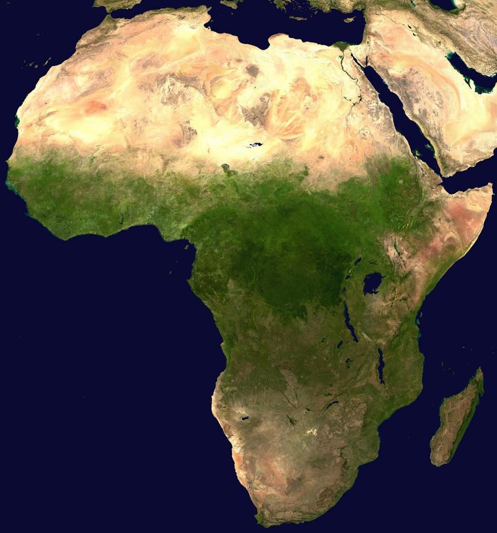
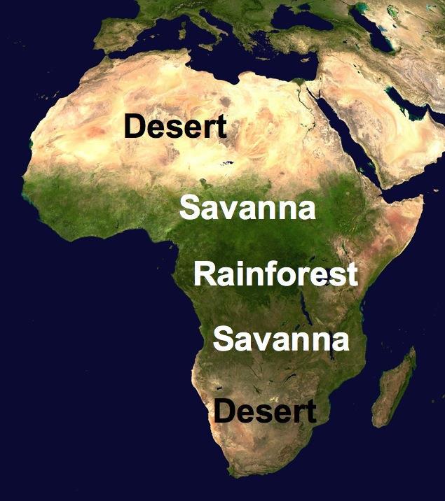
13 Africa is the world s second largest continent (11,700,000 miles). It is home to 52 countries, 1,000 different languages, and 800 million people. 10% of the world s population lives in Africa. The vast African continent has almost every type of landform and climate. Africa can be divided into several regions, including the Sahara, the Sahel, the savannahs, and the tropical rain forests. Brain Wrinkles
14
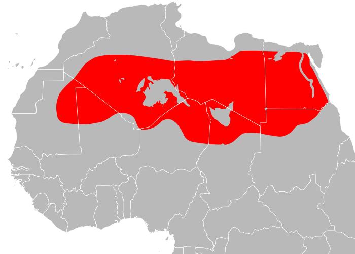
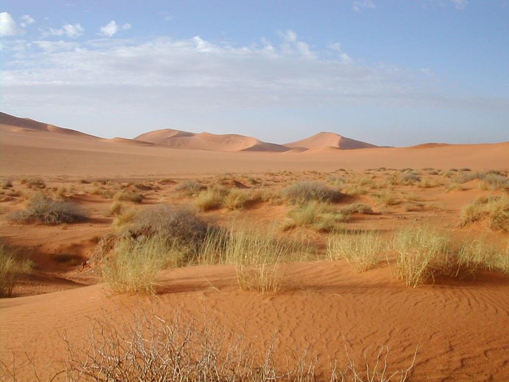
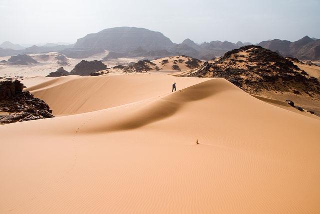
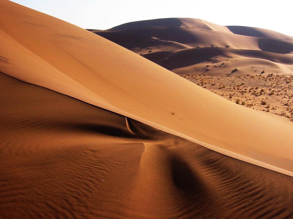
15 The Sahara is the world s largest hot desert (3,500,000 miles). It runs across the width of northern Africa and covers 1/3 rd of the continent. It divides the continent into two distinct regions North Africa and sub-saharan Africa. The Sahara is covered with sand dunes, rocky hills, and stretches of gravel that continue for miles and miles. Brain Wrinkles
16
17
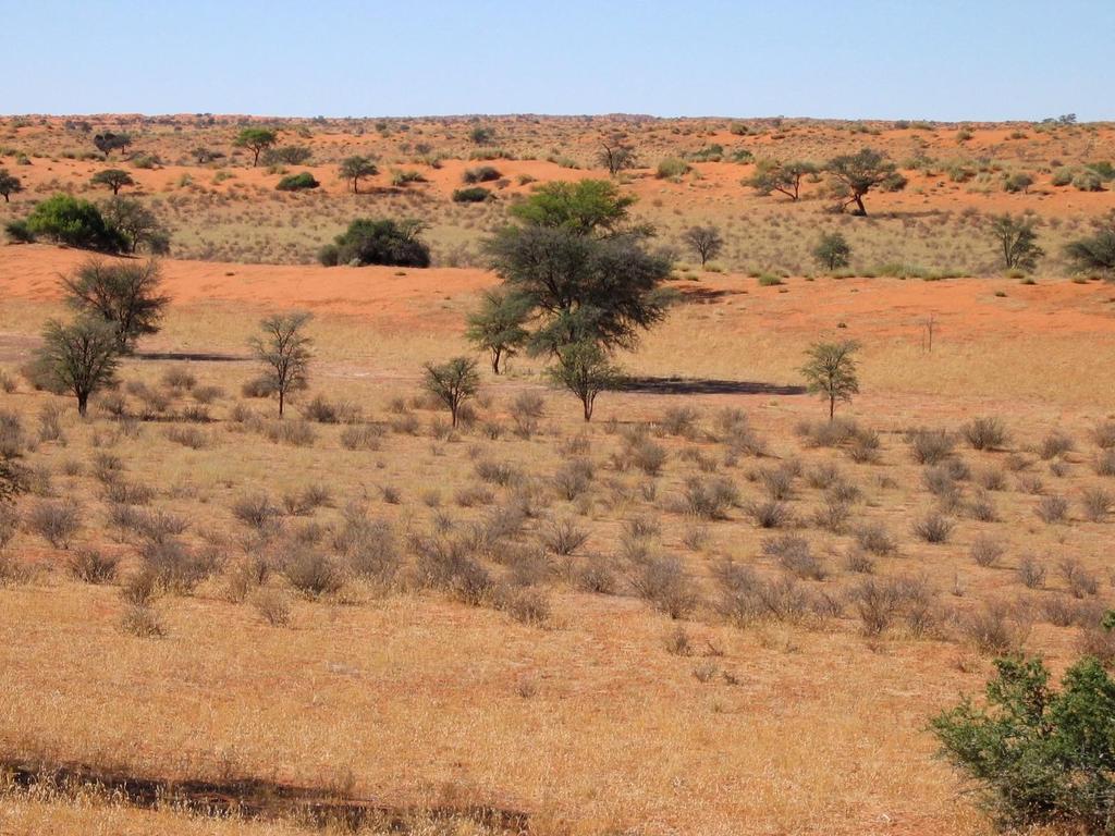
18 Very few people live in the desert because it is considered one of the harshest places to live in the world. The people who do live here are called nomads. They move from place to place, usually traveling by camel, looking for food & water.
19
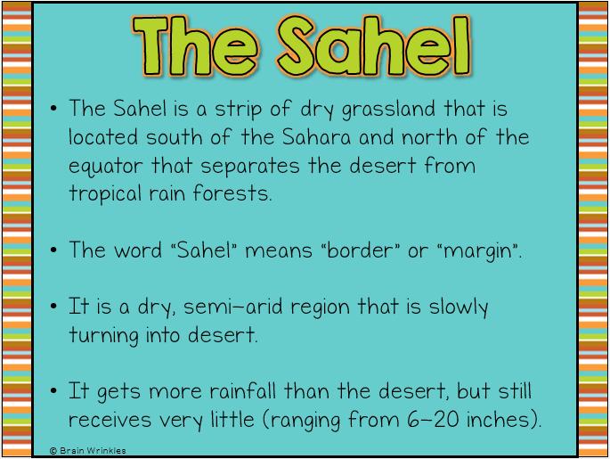
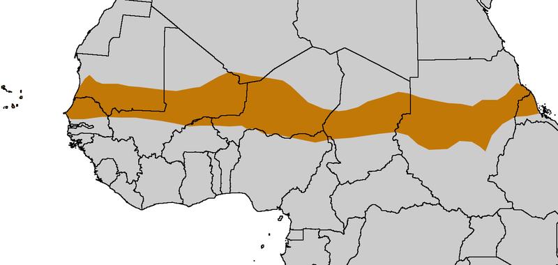
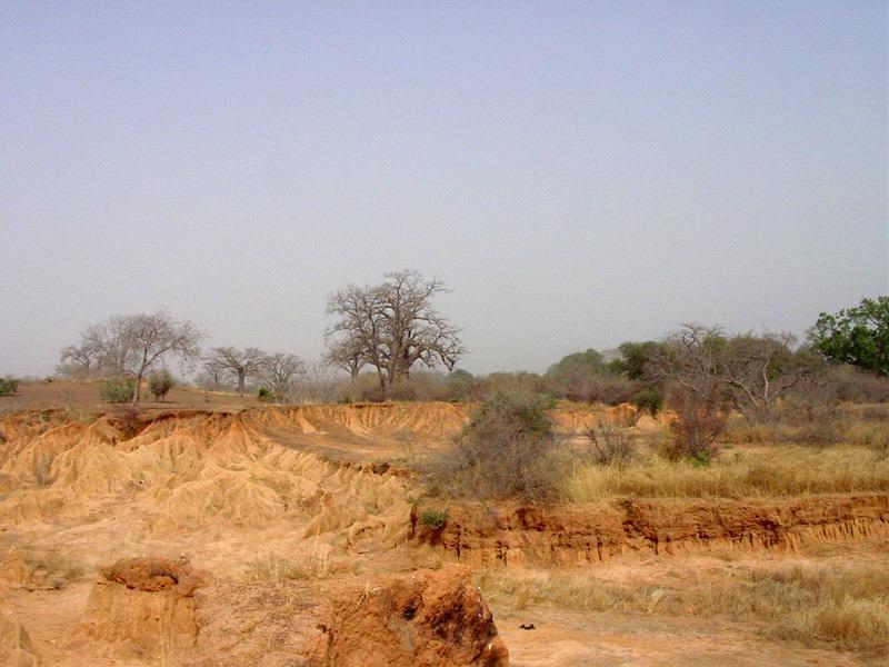
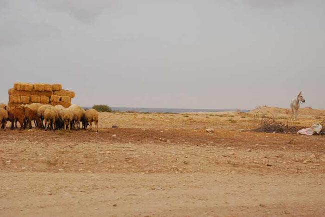
20 The Sahel is a strip of dry grassland that is located south of the Sahara and north of the equator that separates the desert from tropical rain forests. The word Sahel means border or margin. It is a dry, semi-arid region that is slowly turning into desert. It gets more rainfall than the desert, but still receives very little (ranging from 6-20 inches).
21
22

23 The Sahel is relatively flat with few mountains and hills. People have tried to live here but generations of overgrazing and desertification have caused soil erosion. Vegetation is sparse here grasses and shrubs are unevenly distributed.
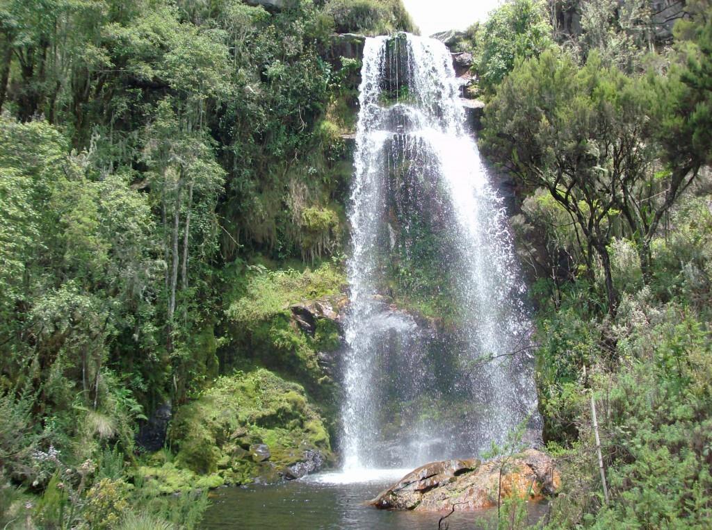
24
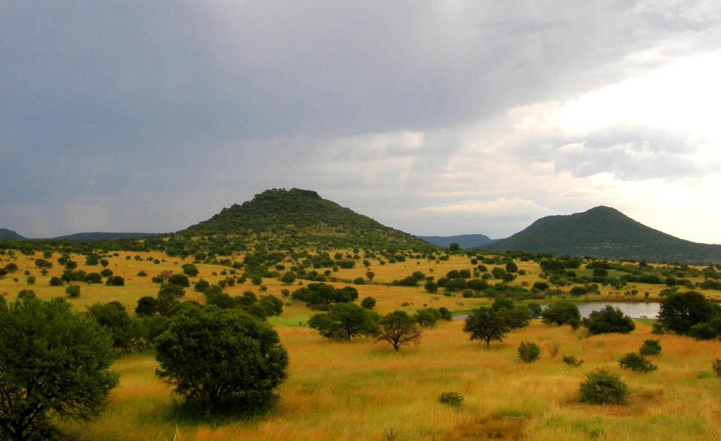
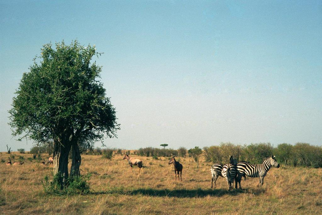
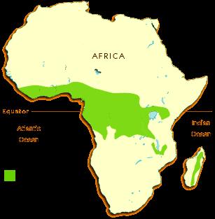
25 The African savannas are hot, dry grasslands that are located near the Equator and cover almost half of Africa. They actually cover the regions just north and south of the rainforests that lie along the equator. The African savanna is the largest in the world (over 4.5 million square miles).
26
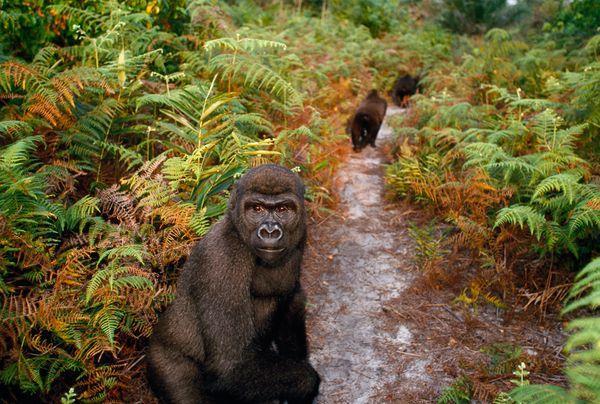
27
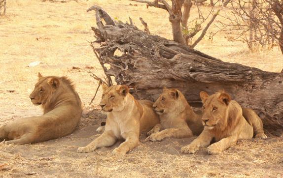
28 The area receives enough rain to support drought resistant undergrowth, but not enough to support forest-type vegetation. Grasses are tall and thick, while trees are short and scattered. Brain Wrinkles There is a large variety of wildlife in the African savannas, including lions, zebras, & elephants. Farming is good here, but only if there is good rainfall. Grasses and grains like wheat, oats, and sorghum grow in the region.
29
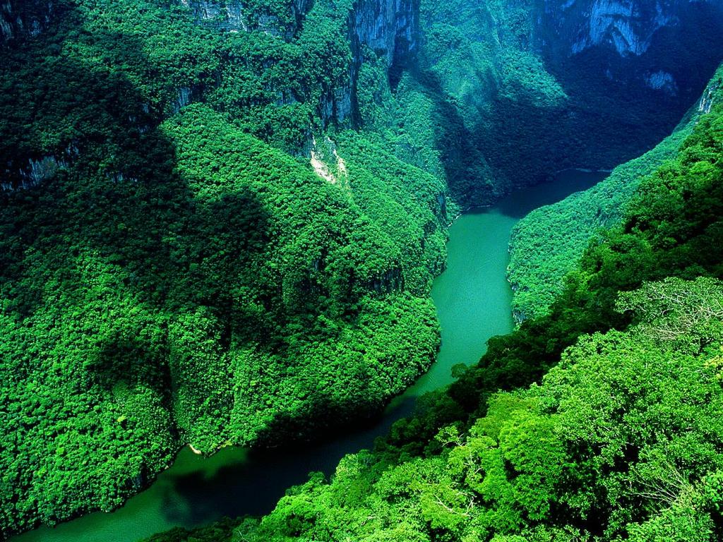
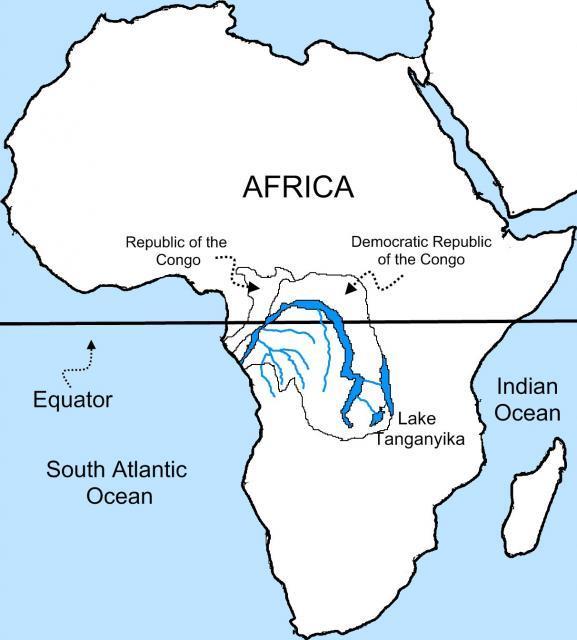
30
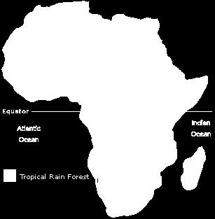
31 Africa s tropical rain forest is located along the central coast of Africa, near the Equator, and lies in the Congo River Basin. The rain forest covers 1/5 th of the land surface of Africa and touches 37 countries. The rain forest has a hot, humid climate with an annual rainfall of over 17 feet.
32
33
34 Africa s tropical rain forest is home to a large variety of animals. Trees are so thick and tall that sunlight never reaches the forest floor! The trees grow hundreds of feet tall. It s the second largest rain forest in the world; the Amazon rain forest in Brazil is the largest. Unfortunately, about 90% of this rain forest has shrunk due to deforestation.
35
36
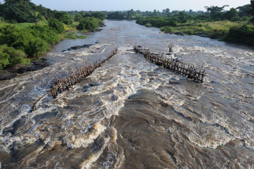
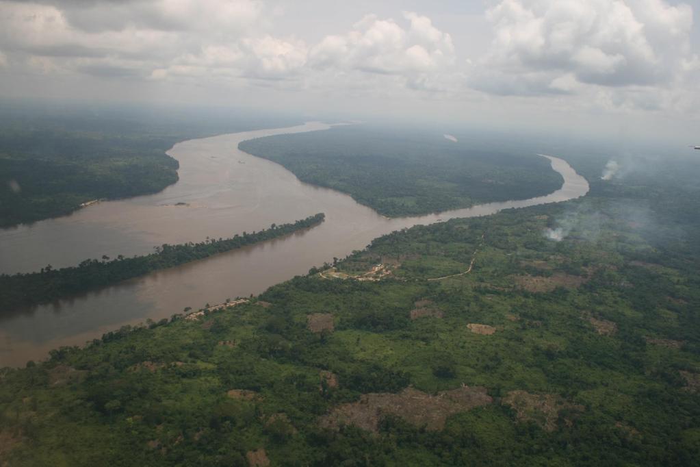
37 The Congo River is located in west central Africa. It begins in central Africa, near Lake Tanganyika, and flows west. It crosses the equator twice and is surrounded by rainforest.
38
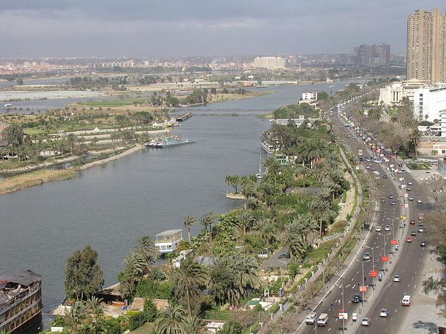
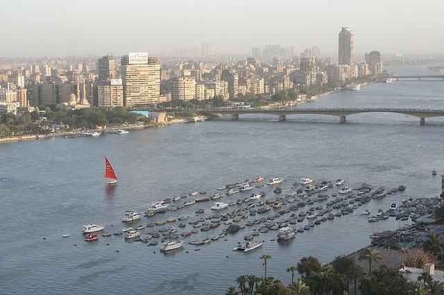
39

40 The Congo River is the second longest river in Africa and the fifth longest in the world. It s over 3,000 miles long.
41
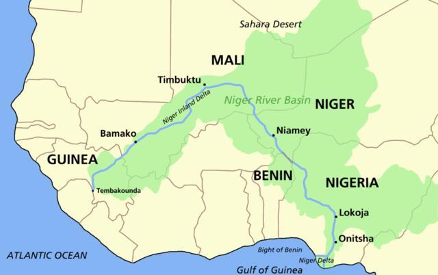
42 The Niger River is located in western Africa. It flows through Guinea, Mali, Niger, Benin, & Nigeria. The Niger River is the third largest river in Africa. It runs over 2,600 miles.
43
44 The mouth of the Niger River flows through a large delta, often referred to as the Oil Delta because of the petroleum industry that s centered here. Brain Wrinkles
45
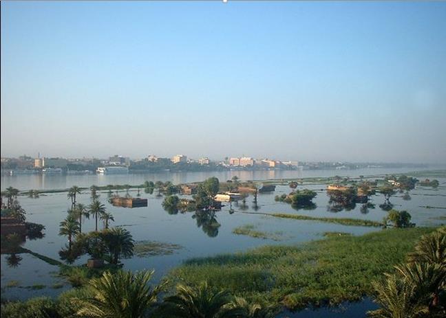
46 The Nile River is located in eastern Africa. It starts in the mountains of central Africa and flows northward through eastern Africa and empties into the Mediterranean Sea. The Nile is the world s longest river at 4,150 miles.


47
48
49 The Nile River provides water for Sudan and Egypt. It s an important waterway for transporting people and goods. The Nile also provides a source of irrigation for agriculture.
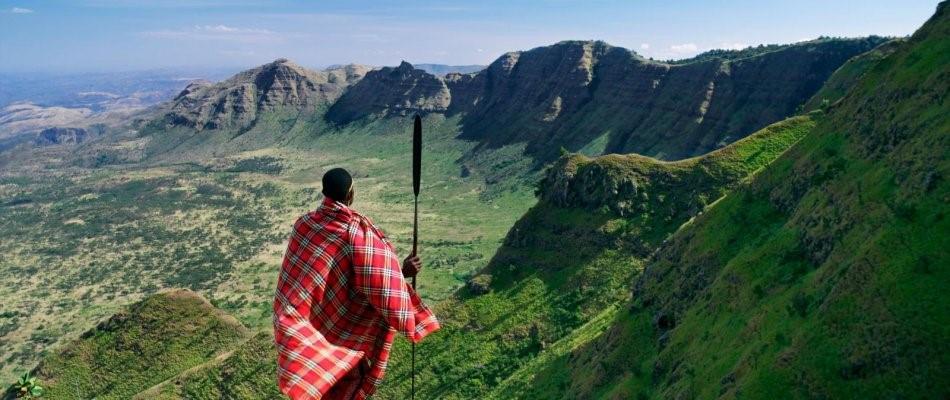
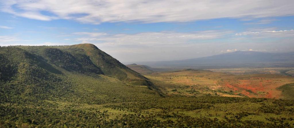
50
51
52 Lake Victoria is a headwaters reservoir for the Nile River. Brain Wrinkles Lake Victoria is the largest lake in Africa and the second largest freshwater lake in the world. (Lake Superior is the largest.) It is located in central Africa and extends into three countries: Tanzania, Uganda, and Kenya.

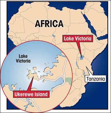
53
54
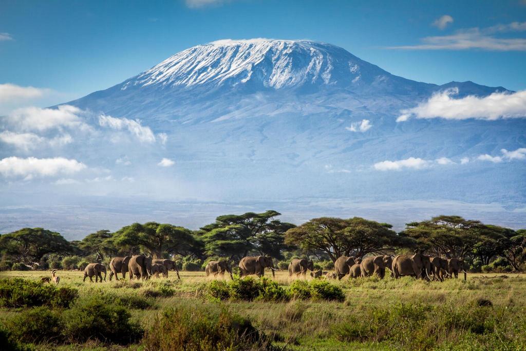
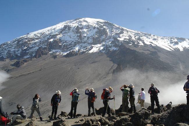
55 Even though it is shallow, Lake Victoria is vital in supporting the millions of people that live nearby. It provides a living for many fishermen and attracts millions of tourists each year.
56
57 The Great Rift Valley is a giant dip in the Earth s surface. It was created about 35 million years ago when the African and Eurasian tectonic plates separated. The valley runs north to south for over 3000 miles, from Syria in Southwest Asia to Mozambique in east Africa.
58
59 The Great Rift Valley varies in width from about 20 to 60 miles. The valley is surrounded by highlands. It contains three of Africa s most important lakes: Lake Victoria, Lake Tanganyika, and Lake Malawi.
60
61

62 Mt. Kilimanjaro is the tallest mountain in Africa. It is located in Tanzania and rises approximately 16,100 feet at its base to 19,340 feet above sea level. The mountain is actually a dormant volcano.
63
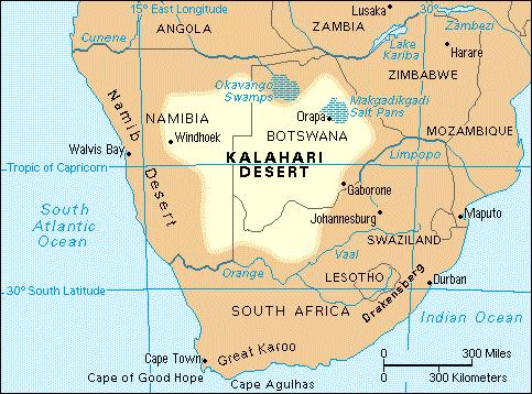
64
65 Mt. Kilimanjaro is part of the Kilimanjaro National Park and is a major climbing destination. The first climbers proven to have reached the summit of the mountain were Hans Meyer and Ludwig Purtscheller in 1889.
66
67 The Atlas Mountains are a mountain range in north Africa. The mountains extend from Morocco to Tunisia, between the Mediterranean Sea and the Sahara desert. They separate the northern coastal regions from the Sahara Desert.
68

69
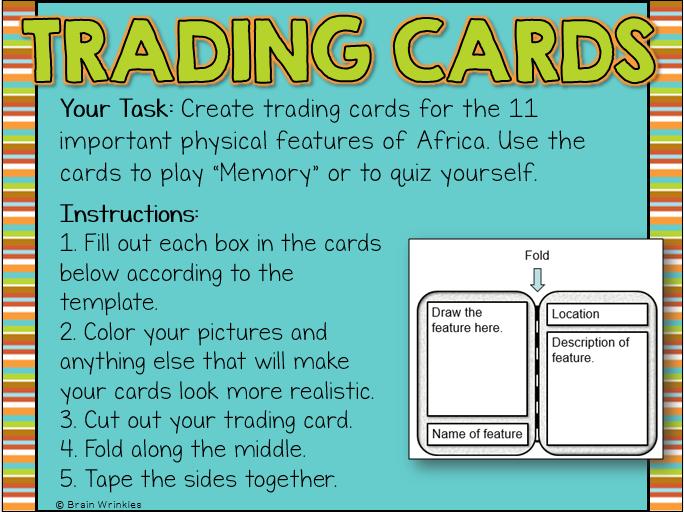
70
71 The region is surrounded by semi-arid areas that are slowly becoming more dry due to desertification. Brain Wrinkles The Kalahari Desert is a large arid to semiarid sandy area that s located in southwestern Africa. It covers parts of Botswana, Namibia, and South Africa. Its dunes range from 20 to 200 feet high and can be 50 miles long.
72
73
74 The Kalahari Desert is not a true desert because it receives 3-10 inches of rain per year. Because of the precipitation and underground water supplies, grass, shrubs, and wild animals manage to live in the Kalahari desert.
75
76
77 TEACHER INFO: Trading Cards Print off the blank trading card page. You can have students create just one trading card, or they can create a card for each feature (12 total). When finished, the students can use the cards to play Memory or to quiz themselves about the features. Project the directions slide onto the board while students are working so that they know what goes in each section.
78

79 Your Task: Create trading cards for the 12 important physical features of Africa. Use the cards to play Memory or to quiz yourself. Instructions: 1. Fill out each box in the cards below according to the template. 2. Color your pictures and anything else that will make your cards look more realistic. 3. Cut out your trading card. 4. Fold along the middle. 5. Tape the sides together. Brain Wrinkles
80 TEACHER INFO: Pass the Paper Put the students into small groups (you will need 11 groups total). Print off the following 11 slides and give one paper to each group. Give each group about 30 seconds to write down everything the know about the feature but they can t write something that is already written. (They can also draw pictures or symbols.) When time is up, they must pass the paper to the next group. This continues until every group has worked with each of the 11 papers. Have each group share the paper & discuss the information.

81 With your group, you will have 30 seconds to write or draw everything that you know about the feature on your paper. Every group member must participate angle yourselves so that you can all write at the same time. The catch is that you cannot write or draw something that is already written! When I say that time is up, you must pass the paper on to the next group. We will continue to Pass the Paper until each group has seen all 11 papers. Brain Wrinkles
82 The Sahara
83 The Sahel

84 The Savanna
85 Tropical Rain Forest
86 Congo River
87 Niger River
88 Nile River
89 Lake Victoria
90 Great Rift Valley
91 Mt. Kilimanjaro
92 Atlas Mountains
93 Kalahari Desert
94 TEACHER INFO: Postcard Print off the postcard page for each student. On the front, the students will draw one of the physical features of Africa. They should also include a short greeting/title. (Example: Cheers from the Kalahari Desert!) On the back, they will write a note to someone as if they have visited some of the features. When finished, they should cut out the postcard, fold along the dotted line, & tape the sides together.
95

96 Front: Draw a colorful illustration of one of the physical features that we have studied. Include a short greeting (title). Back: Write a note to your family as if you have visited some of the features that we have studied in Africa. (Include descriptions for at least 3 of the features.) Don t forget to draw & color the stamp! *Cut out your postcard, fold along the dotted line, & tape the sides together.
97 TEACHER INFO: Comprehension Check Print off the Comprehension Check for each student. The students will complete this handout at the end of the lesson. You can count this as a quiz!
98 1. What is the major landform of northern Africa? 2. What is Africa s transition zone between desert and rain forest? 3. What landform has rolling grassland and scattered trees? 4. What landform lies along the Atlantic coast near the equator? 5. What is the world s longest river? 6. What is the tallest mountain in Africa? 7. What is the world s largest hot desert? 8. What is the southernmost country in Africa? 9. What mountain range is located in northern Africa? 10. Which river is the main river in western Africa? 11. What desert is located in southern Africa? 12. What is the name of the dip in Earth s surface that was caused by separating tectonic plates? Brain Wrinkles
99 1. What is the major landform of northern Africa? Sahara 2. What is Africa s transition zone between desert and rain forest? Sahel 3. What landform has rolling grassland and scattered trees? Savanna 4. What landform lies along the Atlantic coast near the equator? Tropical rain forest 5. What is the world s longest river? Nile River 6. What is the tallest mountain in Africa? Mt. Kilimanjaro 7. What is the world s largest hot desert? Sahara 8. What is the southernmost country in Africa? South Africa 9. What mountain range is located in northern Africa? Atlas Mountains 10. Which river is the main river in western Africa? Niger River 11. What desert is located in southern Africa? Kalahari Desert 12. What is the name of the dip in Earth s surface that was caused by separating tectonic plates? Great Rift Valley Brain Wrinkles
100 TEACHER INFO: TICKET OUT THE DOOR Print off the following slide & make a copy for each student. (They are two-per-page). Have students write down five important things that they learned about Africa s physical features. If time, call on students to share. Collect these as the students leave the classroom.
101 Name: Name: Write down 5 important things that you learned from today s lesson. Write down 5 important things that you learned from today s lesson. Brain Wrinkles Brain Wrinkles


102 Thank you so much for downloading this file. I sincerely hope you find it helpful and that your students learn a lot from it! I look forward to reading your feedback in my store. If you like this file, you might want to check out some of my other products that teach social studies topics in creative, engaging, and hands-on ways. Best wishes, Ansley at Brain Wrinkles


 is strictly forbidden.")
103 . Your download includes a limited use license from Brain Wrinkles. The purchaser may use the resource for personal classroom use only. The license is not transferable to another person. Other teachers should purchase their own license through my store. This resource is not to be used: By an entire grade level, school, or district without purchasing the proper number of licenses. For school/district licenses at a discount, please contact me. As part of a product listed for sale or for free by another individual. On shared databases. Online in any way other than on password-protected website for student use only. Copyright Brain Wrinkles. All rights reserved. Permission is granted to copy pages specifically designed for student or teacher use by the original purchaser or licensee. The reproduction of any other part of this product is strictly prohibited. Copying any part of this product and placing it on the Internet in any form (even a personal/classroom website) is strictly forbidden. Doing so makes it possible for an Internet search to make the document available on the Internet, free of charge, and is a violation of the Digital Millennium Copyright Act (DMCA). Thank you, Ansley at Brain Wrinkles Clipart, fonts, & digital papers for this product were purchased from:
SS7G1 The student will locate selected features of Africa.
 Standards SS7G1 The student will locate selected features of Africa. a. Locate on a world and regional political-physical map: the Sahara, Sahel, savanna, tropical rain forest, Congo River, Niger River,
Brain Wrinkles. Africa: The impact of location, climate, & physical characteristics on where people live, the type of work they do, & how they travel
 Africa: The impact of location, climate, & physical characteristics on where people live, the type of work they do, & how they travel STANDARDS: SS7G3 The student will explain the impact of location, climate,
AFRICAN PHYSICAL GEOGRAPHY
 AFRICAN PHYSICAL GEOGRAPHY Here are some factoids about Africa: world s second largest continent (11,700,000 miles). Home to 52 countries, 1,000 languages, 800 million people. 10% of the world s population
2015 Brain Wrinkles. SS8G1b
 SS8G1b Standards SS8G1 The student will describe Georgia with regard to physical features and location. b. Describe the five geographic regions of Georgia; include the Blue Ridge Mountains, Valley and
How to play. The center aisle divides our class into 2 teams. Team members are NOT allowed to help their teammate when they are asked a question.
 Floaters & Sinkers How to play The center aisle divides our class into 2 teams. Each person will be responsible for answering a question for every round played. Team members are NOT allowed to help their
Introduction to Africa
 Introduction to Africa Did you know? Africa has more countries than any other continent. The Sahara is a desert that is the size of the U.S. It s the world's largest desert. Most of the world s gold and
Chapter 20. The Physical Geography of Africa South of the Sahara
 Chapter 20 The Physical Geography of Africa South of the Sahara Chapter Objectives Identify the major landforms, water systems, and natural resources of Africa south of the Sahara. Describe the relationship
STUDY GUIDE. The Land. Chapter 20, Section 1. The Land of Africa South of the Sahara. Landforms Water Systems Natural Resources.
 For use with textbook pages 499 504. The Land Terms to Know escarpment A steep, often jagged slope or cliff (page 500) cataract A towering waterfall (page 500) rift valley A large crack in the earth s
Just how big is Africa?
 The United States China India The United Kingdom Portugal Spain France Belgium Germany The Netherlands Switzerland Italy Eastern Europe Japan 11.7 million sq. miles Just how big is Africa? Chapter 18 Section
UNIT 5 PHYSICAL GEOGRAPHY SG 1 - PART I
 UNIT 5 PHYSICAL GEOGRAPHY SG 1 - PART I Africa is HUGE! I. LANDFORMS A. Plateaus - an area of relatively level high ground. 1. Africa s interior is dominated by series of plateaus and elevated basins such
Africa: Physical geography
 Africa: Physical geography By National Geographic Society, adapted by Newsela staff on 09.15.17 Word Count 1,279 Level 1040L African elephants roam the savannas, which cover almost half of the African
Location, Climate, & Natural Resources. Where People Live & How They Trade
 Location, Climate, & Natural Resources Where People Live & How They Trade Standards SS6G13 The student will explain the impact of location, climate, distribution of natural resources, and population distribution
Sub - Saharan Africa
 Sub - Saharan Africa 4/14/2015 Countries with Relative Importance GDP South Africa Gabon Botswana Land Size Sudan Chad Mozambique Madagascar Democratic Republic of the Congo (formerly Zaire) Population
2014 Brain Wrinkles. SS8H2a. Creating a
 SS8H2a Creating a in Standards SS8H2 The student will analyze the colonial period of Georgia s history. a. Explain the importance of James Oglethorpe, the Charter of 1732, reasons for settlement (charity,
UNIT 5 AFRICA PHYSICAL GEOGRAPHY SG 1 - PART II
 UNIT 5 AFRICA PHYSICAL GEOGRAPHY SG 1 - PART II III. CLIMATE & VEGETATION A. The four main climate zones are tropical wet, tropical wet/dry (split into monsoon & savanna), semiarid, and arid. Other climate
2009 Carole Marsh/Gallopade International
 Live Work Play Learn LIVE LEARN WORK TM PLAY 2009 Carole Marsh/Gallopade International Permission is hereby granted to the individual purchaser or classroom teacher to reproduce materials in this book
One Commodity Map. 7. What is a commodity? 8. Explain what a one-commodity country is.
 7. What is a commodity? 8. Explain what a one-commodity country is. 9. What must African countries do in order to become more stable economically? One Commodity Map Countries which OIL is the lone commodity
AFRICA'S PHYSICAL FEATURES
 AFRICA'S PHYSICAL FEATURES Looking high and low in Africa This continent's physical features are impressive. From towering, rocky peaks and sleeping volcanoes, like Mount Kilimanjaro, to some of the world
Africa. Physical. Map. Unit. Thanks for Your Purchase! Annabelle ate apples in the purple poppies Thomas Teaching Tools
 Africa Physical Map Unit Thanks for Your Purchase! I hope you and your students enjoy this product. If you have any questions, you may contact me at ThomasTeachingTools@gmail.com. Terms of Use This teaching
Grade 5 Geography Term 1
 1 Grade 5 Geography Term 1 Contents Section 1: World map and compass directions... 2 The position of the equator and the North and South Poles on a globe... 2 The seven continents of the world... 3 The
Physical characteristics and biomes:
 Physical characteristics and biomes: Sahel region, bordering Sahara Characteristics Area suffers from lack of rainfall, over grazing, which causes loss of vegetation and loss of inhabitable areas causing
Unit 1: Physical Geography Notes
 - How has the physical world impacted settlement patterns? o Major factors in the decision-making process of o Before the boom controlling the physical environment was not possible on a large scale - Physical
Countries of the World QTR 3
 As of December 2017 Countries of the World QTR 3 Website: Countries of the World. com https://www.countries-ofthe-world.com/countries-of-north-america.html Website: CIA.gov https://www.cia.gov/index.html
JABALI AFRICAN ACROBATS TEACHER'S NOTES
 JABALI AFRICAN ACROBATS TEACHER'S NOTES Brought to you by Class Act Performing Artists & Speakers; 800-808-0917 JABALI ACROBATS This incredible Kenyan troupe combines Chinese and African traditions of
Unit 6 vocabulary. Serengeti Plain
 basin Nile River rift valley Mount Kilimanjaro escarpment Sahara aquifer oasis Serengeti Plain canopy Niger delta Sahel the world s longest river, flowing more than 4,000 miles through Uganda and Sudan
SS8G1 The student will describe Georgia with regard to physical features and location.
 SS8G1ab Standards SS8G1 The student will describe Georgia with regard to physical features and location. a. Locate Georgia in relation to the region, nation, continent, and hemispheres. b. Describe the
PHYSICAL GEOGRAPHY. Unit 1
 PHYSICAL GEOGRAPHY Unit 1 HOW HAS THE PHYSICAL WORLD IMPACTED SETTLEMENT PATTERNS? Major factor in the decision-making process of settlers Before the technological boom controlling the physical environment
Chapter 13 and 14 Geography Study Guide
 Chapter 13 and 14 Geography Study Guide Multiple Choice Identify the letter of the choice that best completes the statement or answers the question. 1. Which West African country has the largest population
Lesson 1: Geography of Africa
 Lesson 1: Geography of Africa 7. 4. 1 Study the Niger River and the relationship of Vegetation zones of forest, savannah, and desert trade in gold, salt, food, and slaves; and the growth of the Ghana and
STUDY GUIDE. The Land. Chapter 17, Section 1. There are frequent earthquakes in the region. Petroleum is a major export in the region.
 For use with textbook pages 421 426. The Land Terms to Know alluvial soil A rich soil made up of sand and mud deposited by flowing water (page 423) wadi A streambed that remains dry until a heavy rain
Rivers. Highlights of some of the World s Most Famous Rivers!
 Rivers Highlights of some of the World s Most Famous Rivers! Directions This Power Point presentation contains information about some of the most famous rivers in the world! Students should use this presentation
Unit 1. School Days. First Nine Weeks
 Study Buddy Unit 1 School Days First Nine Weeks Teacher- A person who helps us learn. Map- A drawing that shows where places are. Group- A number of people doing an activity together. Rule- What you must
BRITANNICA STUDENT ENCYCLOPEDIA. Africa is the world s second largest continent. More than 50 countries make up
 JOBNAME: No Job Name PAGE: 33 SESS: 682 OUTPUT: Thu Aug 31 10:43:41 2006 38 Africa BRITANNICA STUDENT ENCYCLOPEDIA Africa Africa is the world s second largest continent. More than 50 countries make up
Chapter 17. North Africa, Southwest Asia and Central Asia
 Chapter 17 North Africa, Southwest Asia and Central Asia Chapter Objectives Describe the major landforms and natural resources of North Africa, Southwest Asia, and Central Asia. Discuss the climate and
Connecting Africa. physical Geography
 Connecting Africa physical Geography Africa, the second-largest continent, is bounded by the Mediterranean Sea, the Red Sea, the Indian Ocean, and the Atlantic Ocean. It is divided in half almost equally
Pack Your Geography Terms for a Trip With Maggie and Friends!
 Maggie s Weekly Activity Pack! Name Date Pack Your Geography Terms for a Trip With Maggie and Friends! Do you know where the continents are on the Earth? Are you able to tell which countries are on which
pg. 446 (5 th) pg. 456 (6 th )
 pg. 456 (6 th )") pg. 446 (5 th) pg. 456 (6 th ) African Landscape Plateau Highest in: Ethiopian Highlands Drakensberg Mtns. Lesotho & So. Africa pg. 452 (5 th) pg. 459 (6 th ) Ethiopian Highlands Canyons carved by water
pg. 446 (5 th) pg. 456 (6 th ) African Landscape Plateau Highest in: Ethiopian Highlands Drakensberg Mtns. Lesotho & So. Africa pg. 452 (5 th) pg. 459 (6 th ) Ethiopian Highlands Canyons carved by water
All of this week s homework is intended to help you get to know more about the country of Sudan, where Kek is from in Home of the Brave.
 Name: Week 7 Homework All of this week s homework is intended to help you get to know more about the country of Sudan, where Kek is from in Home of the Brave. On the map above, do the following things:
African Centre of Meteorological Applications for Development Centre Africain pour les Applications de la Météorologie au Développement
 African Centre of Meteorological Applications for Development Centre Africain pour les Applications de la Météorologie au Développement Ten Days Climate Diagnostics Bulletin N 03 Dekad 3, 21 st to 31 st
Africa. Grades 2-5. Barbara Gillespie-Washington. Author
 Illustrators Cheri Macoubrie Wilson Wendy Chang Mary E. Connors Editor Barbara Wally Africa Grades 2-5 Editorial Project Manager Karen J. Goldfluss, M.S. Ed. Editor-in-Chief: Sharon Coan, M.S. Ed. Creative
The A Z of African Countries Notebooking Pages with Backline Maps. Preface
 Preface This book has been created as the basis for unit studies on any (or all) African countries. Whilst each country has available a separate and comprehensive Unit Study, some educators prefer to start
CLIMATE DIAGNOSTIC BULLETIN FOR AFRICA
 CLIMATE DIAGNOSTIC BULLETIN FOR AFRICA N 02 FEBRUARY, 2019 OCEAN-ATMOSPHERE MONITORING & PREDICTION 1 SUMMARY FEBRUARY 2019 The precipitation for the month of February, 2019 was above to well above average
Africa. Display Transparency 6 on the overhead. Explain to students that Africa is the
 3S 4S 1S 2S 3N 4N Banjul Bissau SIERRA LEONE 5N MADEIRA IS. CANARY IS. (SPAIN) (disputed) Dakar Freetown (PORTUGAL) GAMBIA Bamako Conakry Monrovia Rabat BURKINA FASO 1W Accra Lomé ~ Niamey BENIN Algiers
Seven Continents. Grade Level: 1 3
 Seven Continents Grade Level: 1 3 Teacher Guidelines pages 1 2 Instructional Pages pages 3 6 Activity Pages pages 8 14 Practice Page page 15 Homework Page page 16 Answer Key pages 17 18 Classroom Procedure:
African Centre of Meteorological Applications for Development Centre Africain pour les Applications de la Météorologie au Développement
 African Centre of Meteorological Applications for Development Centre Africain pour les Applications de la Météorologie au Développement Ten Day Climate Watch Bulletin N 34 Dekad 1 st to 10 th December,
African Centre of Meteorological Applications for Development Centre Africain pour les Applications de la Météorologie au Développement
 African Centre of Meteorological Applications for Development Centre Africain pour les Applications de la Météorologie au Développement Ten Day Climate Watch Bulletin N 15 Dekad 21 st to 31 st May, 2015
Ten Day Climate Watch Bulletin N 27 Dekad 21 st to 30 th September, 2014
 African Centre of Meteorological Application for Development Centre Africain pour les Applications de la Météorologie au Développement Ten Day Climate Watch Bulletin N 27 Dekad 21 st to 30 th September,
Any Age. Ancient Egypt. Express Lapbook SAMPLE PAGE. A Journey Through Learning
 A J T L Any Age Ancient Egypt Express Lapbook Mini Lapbook, Study Guide, Activities, and Crafts A Journey Through Learning www.ajourneythroughlearning.com Copyright 2013 A Journey Through Learning 1 Authors-Paula
GeoQuest Study for the next Quiz Day:
 GeoQuest Study for the next Quiz Day: February 27 th Angola Botswana Burundi Level 2 February Southern Africa Level 1 Republic of the Congo Democratic Republic of the Congo Equatorial Guinea Level 3 Madagascar
Population (million) % of Africa
 % of Africa") FAO. Irrigation in in figures: AQUASTAT Survey 2005 TABLE 1 al distribution of cultivable and cultivated areas Cultivable areas Cultivated areas in 2002 In cultivable areas (ha) (ha) (%) Northern 65 320
FAO. Irrigation in in figures: AQUASTAT Survey 2005 TABLE 1 al distribution of cultivable and cultivated areas Cultivable areas Cultivated areas in 2002 In cultivable areas (ha) (ha) (%) Northern 65 320
Geography (cont) Sorghum, rice, millet, rice, wheat and corn grown on savannahs. Not just one big plain though mountainous and swampy areas too
 Sorghum, rice, millet, rice, wheat and corn grown on savannahs. Not just one big plain though mountainous and swampy areas too") Geography & Society in Africa: 500 BCE-900 CE Geography Around 5000 miles wide and long Various climates, jungles, snow-capped mountains, deserts and rain-soaked areas. 40% desert - largely uninhabitable
Geography & Society in Africa: 500 BCE-900 CE Geography Around 5000 miles wide and long Various climates, jungles, snow-capped mountains, deserts and rain-soaked areas. 40% desert - largely uninhabitable
African Centre of Meteorological Applications for Development Centre Africain pour les Applications de la Météorologie au Développement
 African Centre of Meteorological Applications for Development Centre Africain pour les Applications de la Météorologie au Développement Ten Day Climate Watch Bulletin N 26 Dekad 11 th to 20 th September,
Key Geographic Features
 DUE 12/6/18 Name: Lesson One: Egypt Geography 6.15 On a historical map locate the Mediterranean and Red Seas, the Nile River and Delta, and the areas of ancient Nubia and Egypt. Identify the locations
1. CLIMATIC AND ENVIRONMENTAL CONDITIONS OVER AFRICA. 1.1 Inter-Tropical Discontinuity (ITD)
") African Centre of Meteorological Application for Development Centre Africain pour les Applications de la Météorologie au Développement DECEMBER 2011 HIGHLIGHT: Cholera, Yellow fever, Avian Influenza, typhoid
African Centre of Meteorological Application for Development Centre Africain pour les Applications de la Météorologie au Développement DECEMBER 2011 HIGHLIGHT: Cholera, Yellow fever, Avian Influenza, typhoid
REPRODUCIBLE MATERIALS
 REPRODUCIBLE MATERIALS Tongass Rainforest by Flickr user Swanksalot In the Deser/Feeling Like Walking by Flickr user Horizon Lonely Island by Flickr user gari.baldi Bombed Hospital by Flickr user The Rocketeer
Unit 9 The Middle East SG 1 - Physical Geography, Population & Demographics
 Unit 9 The Middle East SG 1 - Physical Geography, Population & Demographics I. Physical Geography A. The Middle East includes southwestern Asia and North Africa. 1. The name is Eurocentric. Middle East
Oceania. Australia, New Zealand, and the Pacific Islands. Physical Geography. Where is Australia located?
 Oceania Australia, New Zealand, and the Pacific Islands Physical Geography Australia New Zealand Oceania Where is Australia located? Australia & Oceania are a group of islands located between Asia, Antarctica,
Central Africa Climate?
 Sub-Saharan Africa: All the lands below the Sahara List 4 common traits of countries in Sub-Saharan Africa 4. Define Tribalism and explain how it has affects the region. Chapter 20 Study Guide Define animism
CHAPTER 12. South America. Section 1: Natural Environments Section 2: History and Culture Section 3: South America Today. HOLT World Geography
 CHAPTER 12 South America Section 1: Natural Environments Section 2: History and Culture Section 3: South America 1 Section 1 Natural Environments Objectives: What are the major landforms and rivers of
Latin America s Physical Geography. EQ: What are characteristics of Latin America s physical features?
 Latin America s Physical Geography EQ: What are characteristics of Latin America s physical features? Your Task: We are going to participate in a Museum Walk! You will travel around the room with a partner
M2 Africa Some Basic Facts (Part I) Africa (Year 7)
 Africa (Year 7)") M2 Africa Some Basic Facts (Part I) Africa (Year 7) Take a look in your atlas and find the names of the oceans and seas (numbers 1-8 on the map below) that surround Africa. Write their names in the grid
M2 Africa Some Basic Facts (Part I) Africa (Year 7) Take a look in your atlas and find the names of the oceans and seas (numbers 1-8 on the map below) that surround Africa. Write their names in the grid
Chapter 7 Geography and the Early Settlement of Egypt, Kush, and Canaan
 Chapter 7 Geography and the Early Settlement of Egypt, Kush, and Canaan How did geography affect early settlement in Egypt, Kush, and Canaan? Section 7.1 - Introduction RF/NASA//Corbis This satellite photograph
Notes for the Teacher / Guide. Africa / Uganda
 Notes for the Teacher / Guide Africa / Uganda The aim of the project is to introduce the children of the UK to the landscape of another country and to appreciate similarities and differences. Uganda is
Table A.LPG1 : TOTAL LPG CONSUMPTION (Best available Estimates)
") Table A.LPG1 : TOTAL LPG CONSUMPTION (Best available Estimates) 1000 MT 1 Burkina Faso 0.509 0.587 0.615 0.606 0.435 0.429 0.691 1.057 1.385 1.698 2.156 2.432 2.888 2 Cape Verde 4.058 4.268 4.988 5.259
Table A.LPG1 : TOTAL LPG CONSUMPTION (Best available Estimates) 1000 MT 1 Burkina Faso 0.509 0.587 0.615 0.606 0.435 0.429 0.691 1.057 1.385 1.698 2.156 2.432 2.888 2 Cape Verde 4.058 4.268 4.988 5.259
Energy Poverty in Africa
 African Energy Commission (AFREC) Paper on Energy Poverty in Africa By Dr. Gilbert NZOBADILA Consultant Energy Policy- AFREC 1 1- Introduction: African background : The African Energy Commission (AFREC)
The political economy of resource discoveries. Prof. Michael L. Ross UCLA Department of Political Science September 21, 2011
 The political economy of resource discoveries Prof. Michael L. Ross UCLA Department of Political Science September 21, 2011 Overview 1. Oil and mineral production is spreading to more low-income countries;
student. They should complete the
 Standards SS6H3 The student will analyze important 20th century issues in Latin America and the Caribbean. a. Explain the impact of the Cuban Revolution. Teachers Print off the following page for each
GEOGRAPHY AND HISTORY
 GEOGRAPHY AND HISTORY YEAR 1, PART 1 www.vicensvives.es Contents 01 Our planet Earth 02 The representation of the Earth: maps 03 The Earth s relief 04 Rivers and seas 05 Weather and climate 06 Climates
Chapter 21: EAST AFRICA
 Chapter 21: EAST AFRICA Physical Geography of East Africa Landforms East Africa is a diverse landscape of different plains, volcanic mountains, and plateaus cut by a large valley and marked by many rivers
Cambridge International Examinations Cambridge International Advanced Subsidiary and Advanced Level
 Cambridge International Examinations Cambridge International Advanced Subsidiary and Advanced Level *5153973671-I* TRAVEL AND TOURISM 9395/11 Paper 1 Core May/June 2016 INSERT 2 hours 30 minutes READ THESE
Objective. Students will familiarize themselves with the physical features and climates of Latin America.
 Journal Write KWL What do you KNOW about Latin America? What do you WANT TO KNOW about Latin America? What did you LEARN today that you didn t know before? Latin America Objective Students will familiarize
Ancient Egypt. Life Along the Nile River
 Ancient Egypt Life Along the Nile River 2018 Geography How Does Geography affect the way that people live? Geography- Where in the World? You are Here Streetsboro, Ohio United States of America Geography-
2.1 What is the climate like?
 José Medeiros This fact sheet allows you to see how varied the countryside is across Brazil. 2.1 What is the climate like? Most of Brazil is in the Southern Hemisphere, where the seasons are the opposite
Framework for Progressive Destination Competitiveness
 Sub-Saharan Africa Framework for Progressive Destination Competitiveness SSA Countries by Tourism Development Level and World Bank Income Ranking Tourism development level Pre-emerging Low income Central
Latin America. Chapter 9 Physical Geography
 Latin America Chapter 9 Physical Geography Latin American Regions Middle America includes Mexico and the Central American countries The Caribbean Islands South America Mexico Landforms Sierra Madre Oriental
ì<(sk$m)=beicea< +^-Ä-U-Ä-U
=beicea< +^-Ä-U-Ä-U") Fascinating Facts The Nile River in Egypt is the world s longest river, but the Amazon River in Brazil moves the most water. The world s largest freshwater lake is Lake Baikal in Russia. The highest temperature
Fascinating Facts The Nile River in Egypt is the world s longest river, but the Amazon River in Brazil moves the most water. The world s largest freshwater lake is Lake Baikal in Russia. The highest temperature
STUDY GUIDE. The Land. Physical Features of Latin America. Chapter 8, Section 1. Terms to Know DRAWING FROM EXPERIENCE ORGANIZING YOUR THOUGHTS
 For use with textbook pages 193 198. The Land Terms to Know cordillera A mountain range that runs parallel to another mountain range (page 194) altiplano A high plain (page 194) escarpment A steep cliff
Appendix A Geographic and Geologic Terms Connected With Egypt
 Appendix A Geographic and Geologic Terms Connected With Egypt Egypt Official name is the Arab Republic of Egypt. Total area is 1,002,450 km 2, which makes Egypt the 29th largest country in the world. Only
Southern Africa. Countries, Geography, & Climate
 Countries, Geography, & Climate The Southern African region consists of the following countries: Angola Zambia Malawi Mozambique Zimbabwe Botswana Namibia Swaziland Lesotho South Africa Comoros Madagascar
Ecology and Conservation in Africa
 Ecology and Conservation in Africa Biology 100 Block 8, 2002 Bruce Byers, Visiting Professor Course Description This course will provide an overview of the ecology of Africa and of efforts to conserve
Lakes of Africa. 2. What are two important uses people make of Lake Tanganyika? 4. What are some characteristics of Lake Chad?
 World Lakes Name: Lakes of Africa 1. Why is Lake Tanganyika so long and narrow? 2. What are two important uses people make of Lake Tanganyika? 3. What famous river begins near Lake Victoria? 4. What are
A Snapshot of Sanitation and Open Defecation in Africa 2010 Update
 A Snapshot of Sanitation and Open Defecation in 10 Update A regional perspective based on data from the WHO/UNICEF Joint Monitoring Programme for Water Supply and Sanitation UNICEF/NYHQ10-1999/Asselin
The Galileo Galilei Institute for Theoretical Physics (GGI) plans to organize and host small-size advanced workshops in theoretical particle physics
 plans to organize and host small-size advanced workshops in theoretical particle physics") The Galileo Galilei Institute for Theoretical Physics (GGI) plans to organize and host small-size advanced workshops in theoretical particle physics in its broadest sense. Each workshop will be devoted
The Galileo Galilei Institute for Theoretical Physics (GGI) plans to organize and host small-size advanced workshops in theoretical particle physics in its broadest sense. Each workshop will be devoted
TABLE OF CONTENTS COUNTRY FOCUS: ALGERIA
 Africa Statistics Flash Selected Socio-Economic Indicators on Africa May 218 TABLE OF CONTENTS COUNTRY FOCUS: ALGERIA ---------------------------------------------------------------------------------------------
You can learn more about the trail camera project and help identify animals at WildCam Gorongosa (
 INTRODUCTION Gorongosa National Park is a 1,570-square-mile protected area in Mozambique. After several decades of war devastated Gorongosa s wildlife populations, park scientists and conservation managers
RED CEDAR MODEL UNITED NATIONS. Table of Contents. Letter from the Chair Question of Water Security in Africa: Lake Chat...
 Table of Contents Letter from the Chair... 3 Question of Water Security in Africa: Lake Chat... 4 Introduction to Water Security in Africa... 4 History of Water Security in Africa... 5 Current Issues...
Africa's Top Wildlife Countries: Botswana, Kenya, Namibia, Rwanda, South Africa, Tanzania, Uganda, Zambia & Zimbabwe By Mark W.
 Africa's Top Wildlife Countries: Botswana, Kenya, Namibia, Rwanda, South Africa, Tanzania, Uganda, Zambia & Zimbabwe By Mark W. Nolting This is a list of national parks in Africa. The nature of the parks
What is new on the T4A GPS Maps Traveller s Africa 16.10
 What is new on the T4A GPS Maps Traveller s Africa 16.10 T4A GPS Maps 16.10 comes preloaded on a micro SD card with standard adapter, ready for Plug & Navigate. This SD card can be used on most map capable
7/27/2010. Regions of Subsaharan Africa. SUBSAHARAN AFRICA II (Chapter 6, pages ) Southern Africa. South Africa: Peaceful Change from Apartheid
 Southern Africa. South Africa: Peaceful Change from Apartheid") SUBSAHARAN AFRICA II (Chapter 6, pages 209-227) Regions of Subsaharan Africa Southern Africa 10 countries, 6 of them landlocked Congo Basin marks northern limit Plateau country Rich in natural resources
SUBSAHARAN AFRICA II (Chapter 6, pages 209-227) Regions of Subsaharan Africa Southern Africa 10 countries, 6 of them landlocked Congo Basin marks northern limit Plateau country Rich in natural resources
Chapters 14 and 15 Geography Study Guide
 Chapters 14 and 15 Geography Study Guide Multiple Choice Identify the letter of the choice that best completes the statement or answers the question. 1. Gorillas live within dense rain forests of. a. Rwanda
Africa 1. About how many miles is it from the capital of Burkina Faso to the capital of Gambia? 3. What country has the second highest birthrate?
 Pts Answers - (Write answers in Answers column. Do Not mark in Pts. Column.) Africa 1. About how many miles is it from the capital of Burkina Faso to the capital of Gambia? 2. The continent's two largest
NATIONAL SENIOR CERTIFICATE NATIONAL GRADE 12
 NATIONAL SENIOR CERTIFICATE NATIONAL GRADE 12 GEOGRAPHY P1 FEBRUARY/MARCH 2013 ANNEXURE This annexure consists of 12 pages. Geography/P1 2 DBE/Feb. Mar. 2013 FIGURE 1.1: GLOBAL PRESSURE BELTS AND WINDS
The Second Japan-Africa Business Forum TICAD and Business: Feedback from the Yokohama Action Plan to the Nairobi Declaration July 25, 2017
 The Second Japan-Africa Business Forum TICAD and Business: Feedback from the Yokohama Action Plan to the Nairobi Declaration July 25, 207 Takeshi Osuga Ambassador, Assistant Minister, Director-General
Latin America. Introduction
 Latin America Introduction What are the 5 Themes of Geography? Draw lines to connect the theme to the definition: Location How humans and the environment impact each other Physical and human characteristics
Southern Africa outpaces North Africa in governance performance
 Monday 5 th October 2009 Southern Africa outpaces North Africa in governance performance 2009 Ibrahim Index of African Governance shows that half of Africa s ten best performing countries are in Southern
A funny sounding lake. South American Landforms, Climate, and Vegetation
 A funny sounding lake South American Landforms, Climate, and Vegetation 3 4 Essential Question: How have physical features and climate affected the population distribution of Latin America? 5 I. Landforms
Latin America. Physical Geography
 Latin America Physical Geography Regions Latin America can be divided into separate regions based on physical geography or cultural geography. Regions If we look at physical geography Latin America has
Table of CONTENTS. COUNTRY FOCUS: United Republic of Tanzania
 Africa Statistics Flash Selected Socio-Economic Indicators on Africa December 216 Table of CONTENTS COUNTRY FOCUS: United Republic of Tanzania ------------------------------------------------------------
!!!!!!!!!!Mali s Geographic Makeup
 DANU Strategic Forecasting Group May 27th 2016!!!!!!!!!!Mali s Geographic Makeup By Liliana Pirlea Location: Mali is a landlocked country located in West Africa. Mali is the 8th largest country in Africa
Regional Atlas: Introduction to Latin America
 Chapter 9, Section World Geography Chapter 9 Regional Atlas: Introduction to Latin America Copyright 2003 by Pearson Education, Inc., publishing as Prentice Hall, Upper Saddle River, NJ. All rights reserved.