We are pleased to present Delores Reuter Estate ± Acres Decoria Township, Blue Earth County
|
|
|
- Dinah Floyd
- 5 years ago
- Views:
Transcription

1 We are pleased to present Delores Reuter Estate ± Acres Decoria Township, Blue Earth County This property to be sold by Sealed Bid Auction Owner: Delores Reuter Estate Owner s Attorney: Richard Kakeldey, Jones Law Office, Mankato, MN Date & Time: Tuesday, June 26th, 10 a.m. Location: MN National Guard, 100 Martin Luther King Jr Dr, Mankato, MN Note: See Sealed Bid Information page in the back of this brochure for more details. Only registered bidders may attend. Must be registered prior to auction date. Listing Agent: Charles Wingert, ALC Office: LAND (5263) Toll Free: LAND (5263) Direct: Auctioneer # Charles@WingertRealty.com

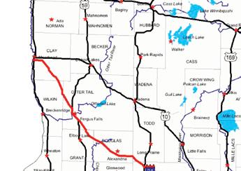


2 State Highway Map Minneapolis SUBJECT PROPERTY Mankato
3 Blue Earth County Minnesota SUBJECT PROPERTY

4 Decoria Township Blue Earth County SUBJECT PROPERTY

5 FSA Aerial View
6 Property Information DESCRIPTION: TAX PID #: BUILDINGS: 78.48± Acres. N½ of SE¼ Exc a Co. Hwy. Section 35. T107N-R26W (not to be used on legal documents) (Decoria Township, Blue Earth County, Minnesota) R None REAL ESTATE TAXES: Total 2018 taxes = $5, Ag Non Hmstd = $4, Special Assessments = $1, (breakdown below) CD 86 1 yr maintenance (101.73) CD 86 7 yr repair ($962.19) $5, remaining balance. Payments go until Admin costs ($77.52) NOTE: Taxes will be pro-rated the day of closing. FSA INFORMATION: Total acres = ± acres FSA Tillable acres = 77.4 ± acres Corn base acres = 50.4 ± acres Corn PLC Yield =163 ± bushels Soybean base acres = 26.6 ± acres Soybean PLC Yield = 44 ± bushels Wheat base acres = 0.4 ± acres Wheat PLC Yield = 40 ± bushels Farm Program Info - Enrolled into Agricultural Risk Coverage (ARC) County 2018 LEASE: The farm is rented at a competitive cash rental rate. NOTE: Rent will be pro-rated to the day of closing. SOIL DESCRIPTION: Minnetonka, Waldorf, Lura, Shorewood, Le Sueur. See Soils Map. CPI: Crop Productivity Index = 79.9 TOPOGRAPHY: DRAINAGE: Level to rolling Outlet: County Ditch #86. Northwest watershed outlet 8 Lateral 1I draining north. Remainder of farm drains south into 12 & 10 Branch #5. Private Tile: Mains & System tiling. See Tile Map. NRCS CLASSIFICATIONS ON TILLABLE ACRES: Exempt from conservation compliance provisions. NHEL - Non-Highly Erodible Land WINGERT REALTY & LAND SERVICES, INC. stipulates that they are representing the seller exclusively in this transaction. The information gathered for this brochure in its entirety is from sources deemed reliable, but cannot be guaranteed by Seller, Wingert Realty & Land Services, Inc., or its staff. Package is subject to prior sale, price change, correction or withdrawal. The buyer must make their own independent investigation of the property. The buyer is purchasing the property as is.

7 County Ditch # 86 Tile Map This tile map is an approximation. Wingert Realty & Land Services, Inc. does not guarantee tile maps, footage, tile condition, location, size, grade or depth. SUBJECT PROPERTY


8 County Ditch # 86 Tile Map This tile map is an approximation. Wingert Realty & Land Services, Inc. does not guarantee tile maps, footage, tile condition, location, size, grade or depth. SUBJECT PROPERTY
9 Tile Map This tile map is an approximation. Wingert Realty & Land Services, Inc. does not guarantee tile maps, footage, tile condition, location, size, grade or depth.

10 Tile Map This tile map is an approximation. Wingert Realty & Land Services, Inc. does not guarantee tile maps, footage, tile condition, location, size, grade or depth.
11 Tile Map This tile map is an approximation. Wingert Realty & Land Services, Inc. does not guarantee tile maps, footage, tile condition, location, size, grade or depth.
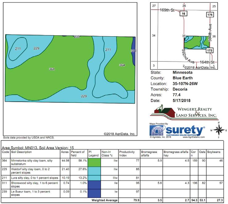
12 Soils Map
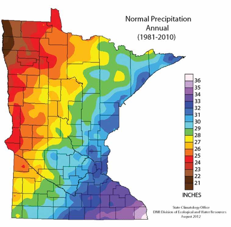
13 MINNETONKA SERIES - Soil # 364 Soil Descriptions WALDORF SERIES - Soil # 229 The Minnetonka series consists of deep poorly drained soils that formed in glacial lacustrine sediments on glacial lake plains and moraines. These soils have slow permeability. Their slopes range from 0 to 3 percent. Mean annaul precipitation is about 28 inches, and mean annual temperature is about 47 degrees F. TYPICAL PEDON: Minnetonka silty clay loam with a plane slope of less than 1 percent on a glacial lake plain in a cultivated field. GEOGRAPHIC SETTING: Minnetonka soils have slightly concave through slightly convex slopes on glacial lake plains and on glacial moraines that have a mantle of lacustrine sediments. Their slopes range from 0 to 3 percent. They formed in layer of clayey lacustrine deposits ranging from about 2 1/2 to 10 feet or more in thickness. These deposits typically overlie friable loam till, but in some places silty lacustrine deposits as much as 3 feet in thickness are between the clayey sediments and till. These sediments are Late Wisconsin Age. The climate is humid continental with warm summers and cold winters. Mean annual temperature is 45 to 50 degrees F, and mean annual precipitation is 25 to 30 inches. GEOGRAPHICALLY ASSOCIATED SOILS: The main ones are Barbert, Shorewood, and Lura soils which formed in sediments similar to those of the Minnetonka soils. Moderately and somewhat poorly drained Shorewood soils are on higher lying or more sloping terrain. The very poorly drained Barbert soils are in shallow depressions. The very poorly drained Lura soils are in distinct depressions. DRAINAGE AND PERMEABILITY: Poorly drained. Surface runoff is slow. Permeability is slow. The Waldorf series consists of very deep, poorly drained soils formed in lacustrine sediments on glacial lake plains and moraines. These soils have moderately slow or slow permeability. Slopes range from 0 to 2 percent. Mean annual precipitation is about 27 inches. Mean annual air temperature is about 48 degrees F. TYPICAL PEDON: Waldorf silty clay loam on a nearly level slope in a cultivated field. GEOGRAPHIC SETTING: These soils are on plane to slightly concave positions on lake plains or moraines covered by lacustrine sediments. Slope gradients are 0 to 2 percent. The Waldorf soils formed in fine or moderately fine textured lacustrine sediments that are 4 to more than 10 feet in thickness. These sediments are Late Wisconsin in age. The climate is midcontinental with warm summers and cold winters. Mean annual air temperature is about 45 to 50 degrees F. Mean annual precipitation is about 25 to 32 inches. Elevation above sea level ranges from 700 to 1200 feet. Frost-free days range from 124 to 172. GEOGRAPHICALLY ASSOCIATED SOILS: The Collinwood, Brownton, Lura, and Kamrar soils are the major ones. These soils formed in similar sediments and are members of a hydrosequence with Waldorf soils. The well-drained Kamrar soils are on backslopes, shoulders and summits. The moderately well and somewhat poorly drained Collinwood soils are on nearby low summits. The poorly and very poorly drained calcareous Brownton soils are on nearby nearly level positions on rims of depressions. Lura soils are very poorly drained and are in depression. DRAINAGE AND PERMEABILITY: Poorly drained. An apparent water table is at.5 to 1.5 feet from November to July in most years. Surface runoff is low. Permeability is moderately slow or slow
14 Soil Descriptions LURA SERIES - Soil # 211 The Lura series consists of very deep, very poorly drained and poorly drained soils that formed in clayey glacial lacustrine sediments on glacial lake plains, and ground moraines. These soils have slow permeability. They have slopes of 0 to 2 percent. Mean annual precipitation is about 28 inches. Mean annual air temperature is about 48 degrees F. TYPICAL PEDON: Lura silty clay with a concave slope of about 1/4 percent in a depression on a lacustrine-mantled ground moraine in a cultivated field. GEOGRAPHIC SETTING: Lura soils primarily are in depressions on glacial lake plains and lacustrine-mantled till plains or ground moraines, but some are along drainageways. They have slopes of 0 to 2 percent. These soils formed primarily in clayey lacustrine sediments of Late Wisconsinan Age. Calcareous loam or clay loam glacial till underlies the lacustrine sediments at depths ranging from 40 inches to 10 feet or more. Mean annual precipitation ranges from 26 to 32 inches. Mean annual air temperature ranges from 45 to 52 degrees F. Frost-free days range from 124 to 172. Elevation above sea level ranges from 700 to 1570 feet. GEOGRAPHICALLY ASSOCIATED SOILS: The Beauford, Collinwood, Guckeen, Marna, and Waldorf soils are the main ones. The poorly drained Beauford soils contain more clay than the Lura soils and are associated with them in a few places. The somewhat poorly drained Collinwood and the poorly drained Waldorf soils formed in 48 inches or more of lacustrine sediments and have sola with texture similar to that of the Lura soils. The somewhat poorly drained Guckeen and the poorly drained Marna soils formed in a mantle of clayey lacustrine sediments and have loamy glacial till within depths of 40 inches. DRAINAGE AND PERMEABILITY: Very poorly drained and poorly drained. Surface runoff is slow to ponded. Permeability is slow. An apparent seasonal high water table for the undrained phase is at 1 foot above the surface to 1 foot below at some time during November to July in most years for the very poorly drained phase and 1.0 feet to 3 feet for the poorly drained phase. SHOREWOOD SERIES - Soil # 311 The Shorewood series consists of very deep, moderately well drained and somewhat poorly drained soils that formed in a mantle of clayey glacial lacustrine sediments and underlying loamy calcareous till or that formed entirely in lacustrine sediments. These soils are in glacial lake plains and moraines. Permeability is moderately slow or slow. Slopes range from 0 to 12 percent. Mean annual precipitation is about 28 inches. Mean annual temperature is about 47 degrees F. TYPICAL PEDON: Shorewood silty clay loam with a slightly convex 3 percent slope in a cultivated field. GEOGRAPHIC SETTING: Shorewood soils have plane or slightly convex slopes on glacial lake plains and moraines. Slopes generally are about 100 to 250 feet in length with gradients of 0 to 12 percent. The Shorewood soils formed in clayey lacustrine material commonly 30 to 60 inches or more in thickness over friable loam or clay loam glacial till. In some pedons a silty layer up to 3 feet thick is between the clayey layer and the underlying deposits. Mean annual temperature is about 45 to 50 degrees F. Mean annual precipitation is about 25 to 32 inches. Frost free days range from 124 to 165. Elevations above sea level range from 900 to 1200 feet.
15 Soil Descriptions GEOGRAPHICALLY ASSOCIATED SOILS: These are the Minnetonka, Barbert, and Lura soils which are members of a hydrosequence with Shorewood soils. Poorly drained Minnetonka soils are on nearby level terrain. Very poorly drained Barbert and Lura soils are in depressions and swales. DRAINAGE AND PERMEABILITY: Moderately well and somewhat poorly drained. Surface runoff is medium. Permeability is moderately slow or slow. The perched water table for the moderately well drained phase is 2.5 to 4.0 April to June, and 1.5 to 2.5 for the moderately wet phase in most years. Le Sueur soils and are members of a hydrosequence with the Le Sueur soils. The poorly drained Cordova and Hamel soils are common associates on adjacent nearly level slopes. The well drained Lester soils are the most common associate on the undulating to gently undulating slopes. The well drained Hayden soils and the poorly drained Dundas soils are associates in some places. DRAINAGE AND PERMEABILITY: Moderately well drained. Surface runoff is slow. Permeability is moderate. An apparent water table is at 2.5 to 4 feet during November to June in most years. LE SUEUR SERIES - Soil # 239 The Le Sueur series consists of very deep, moderately well drained soils that formed in calcareous loamy glacial till on moraines. These soils have moderate permeability. Their slopes range from 1 to 3 percent. Mean annual precipitation is about 29 inches. Mean annual air temperature is about 47 degrees F. TYPICAL PEDON: Le Sueur clay loam with a 2 percent plane slope on glacial till plain in a pastured woodlot. GEOGRAPHIC SETTING: The Le Sueur soils have slightly concave, plane, or slightly convex slopes on moraines within the Des Moines lobe and Grantsburg sublobe of the Late Wisconsin glaciation. They formed in a calcareous, loamy till. Slopes range from 1 to 3 percent. Mean annual air temperature ranges from 45 to 52 degrees F. Mean annual precipitation ranges from 25 to 32 inches. Frost-free days range from 125 to 165. Elevation above sea level ranges from 700 to 1600 feet. GEOGRAPHICALLY ASSOCIATED SOILS: The main ones are the Cordova, Lester, and Hamel soils. These soils formed in materials similar to the
16

17
18 SEALED BID AUCTION INSTRUCTIONS Sealed Bid Location and Time: MN National Guard 100 Martin Luther King Jr Dr, Mankato, MN Tuesday, June 26th, 10 a.m. Sealed Bid Instructions: 1. Only registered bidders may attend. Must be registered prior to auction date. All potential bidders shall deliver or mail a sealed bid, postmarked by Thursday, June 21, 2018 to: Wingert Realty & Land Services, Inc., Attn: Charles Wingert 1160 Victory Drive So., Suite 6, Mankato, MN **If you are unable to get postmarked bid in on time, call our office for other arrangements. 2. All bids must be accompanied by a $5,000 check for earnest money made out to Wingert Realty Trust Account. 3. The written bid shall state the total price for total deeded acres. 4. All persons submitting a written bid will be allowed to raise their bid after all bids have been opened. 5. The premises described herein will be sold in as is, where is condition 6. Seller & purchaser will prorate 2018 rent income, real estate taxes and special assessments to the date of closing. 7. The successful bidder or bidders will enter into a Purchase Agreement and shall pay as earnest money 10% of the successful bid on the day of auction. 8. A 2% Buyer Premium will be added to the final bid price to arrive at the final contract price. 9. The entire balance of the purchase price, without interest, will be due and payable on Tuesday, July 31, 2018 at which time possession and marketable title shall be conveyed. 10. All checks will be returned to unsuccessful bidder. 11. The Sellers reserve the right to reject any and all bids and to waive any irregularities in the bidding. 12. Announcements made the day of the auction take precedence over written material. For additional information, contact: Wingert Realty & Land Services, Inc. Charles Wingert, ALC, Auctioneer # (800) 730-LAND (5263), LAND (5263) or Direct
 for earnest money made out to Wingert Realty Trust Account.")
19 REGISTRATION / BIDDING FORM Bid Submitting Instructions: Write in your total price for total deeded acres for each parcel you would like to bid on Write in your name, address, telephone number and address All bids must be accompanied by a $5,000 check (this check covers any and all parcels you wish to bid on) for earnest money made out to Wingert Realty Trust Account. Only registered bidders may attend. Must be registered prior to auction date. All potential buyers shall deliver or mail a sealed bid, postmarked by Thursday, June 21, 2018 to: Wingert Realty & Land Services, Inc., Attn: Charles Wingert 1160 Victory Drive So., Suite 6, Mankato, MN If you are unable to get postmarked bid in on time, call our office for other arrangements. Refer to the Delores Reuter Estate brochure for further details concerning bidding procedures. Also available to print online: ACRES ± TOTAL BID AMOUNT (Nearest $1,000) $ NAME: ADDRESS: CITY / STATE / ZIP: CELL PHONE: ( ) /RESIDENTIAL ( ) ADDRESS:
20 WINGERT REALTY & LAND SERVICES, INC. Serving Minnesota and Northern Iowa Mankato Office: Toll Free LAND (5263) Local LAND (5263) CHARLES WINGERT, ALC PAST NATIONAL PRESIDENT OF REALTORS LAND INSTITUTE (2013) Broker Direct Line: DARRELL HYLEN, ALC Real Estate Sales & Lease Negotiation Direct Line: Auctioneer # Auctioneer # DAVID HANSON Real Estate Sales Direct Line: David@WingertRealty.com Auctioneer # Redwood Falls Office: RICHARD HAUGE, ALC & ARA Real Estate Sales & Appraisals Direct Line: Rick@WingertRealty.com Auctioneer # ALL ARE LICENSED MN REALTORS THE LAND REPORT, the magazine of the American Landowner, has named Wingert Realty & Land Services, Inc. America s Best Brokerages and Top Auction Houses in the U.S.A.! 5/29
We are pleased to present Peter & Arlyss Dirkx Farm 120 ± Acres Sterling Township, Blue Earth County
 We are pleased to present Peter & Arlyss Dirkx Farm 120 ± Acres Sterling Township, Blue Earth County PARCEL 1 PARCEL 2 PARCEL 3 = PARCELS 1+2 This property to be sold by Sealed Bid Auction Owner: Arlyss
We are pleased to present Stattelman Trust - Todd County ± Acres Bertha Township, Todd County
 We are pleased to present Stattelman Trust - Todd County 86.90 ± Acres Bertha Township, Todd County SUBJECT PROPERTY This property to be sold by Sealed Bid Auction Owner: Stattelman Trust; Thomas Stattelman,
Purchase Price: $110,000
 We are pleased to present Laumann Property 40 ± Acres Hunting & Recreation Beauford Township, Blue Earth County Subject Property Access Easement Owners: Laumann Family Location: Two one half mile east
We are pleased to present Kingery Farm 144 ± Acres Worthington Township, Nobles County
 We are pleased to present Kingery Farm 144 ± Acres Worthington Township, Nobles County SUBJECT PROPERTY This property to be sold by Sealed Bid Auction Owner: John Kingery, Ann Schlomann and Paula Seep
We are pleased to present Cummiskey Farm 80 ± Acres Farmland & Hunting/Rec. Kilkenny Township, Le Sueur County
 We are pleased to present Cummiskey Farm 80 ± Acres Farmland & Hunting/Rec. Kilkenny Township, Le Sueur County SUBJECT PROPERTY View drone video at www.wingertrealty.com This property to be sold by Sealed
We are pleased to present Roland Hammer Children s Trust 80 ± Acres Hantho Township, Lac Qui Parle County
 We are pleased to present Roland Hammer Children s Trust 80 ± Acres Hantho Township, Lac Qui Parle County This property to be sold by Sealed Bid Auction Owner: Roland Hammer Children s Trust - Joe Hammer,
Introduction. Implementation of the Village of Capac Master Plan
 Implementation of the Village of Capac Master Plan Introduction The key to a well-planned community is the actual day-to-day use of planning documents, like this Master Plan. Because this plan is to be
Arrowhead Ranch. Located in the Big Range Country of Central Wyoming.
 Arrowhead Ranch Located in the Big Range Country of Central Wyoming. 58 E. Benteen Street Buffalo, WY 82834 Ph 307-684-9556 Toll Free 888-684-9557 Fax 307-684-8565 Location The ranch is approximately:
KNIGHTS LANDING RIVER RANCH WOODLAND, CA - YOLO COUNTY
 PROPERTY HIGHLIGHTS ±77.2 Gross Acres Contains Excellent Sandy and Silty Clay Loam Soils Established Surface Water Rights in Sacramento River Developed River Diversion and Distribution System Three Phase
HIGH QUALITY FARMLAND PORTFOLIO MONROE COUNTY, ILLINOIS 670 ACRES M/L
 HIGH QUALITY FARMLAND PORTFOLIO MONROE COUNTY, ILLINOIS 670 ACRES M/L HIGH QUALITY FARMLAND PORTFOLIO Monroe County, Illinois 670 Acres M/L Mississippi River St. LOUIS, MISSOURI Monroe CouNTy, Illinois
(Short Listing) DUPUYER ACREAGE, ROCKY MOUNTAN FRONT
 DUPUYER ACREAGE, ROCKY MOUNTAN FRONT") (Short Listing) DUPUYER ACREAGE, ROCKY MOUNTAN FRONT This unique property is located 8½ miles northwest of Dupuyer, Montana and approximately thirty 30 miles northwest of Choteau, Montana. Great Falls
(Short Listing) DUPUYER ACREAGE, ROCKY MOUNTAN FRONT This unique property is located 8½ miles northwest of Dupuyer, Montana and approximately thirty 30 miles northwest of Choteau, Montana. Great Falls
BRANDON PLANTATION Auction
 BRANDON PLANTATION Auction historical virginia landmark plantation // 23500 brandon road // spring grove, VA in conjunction with richard buckingham OF RE/MAX COMMONWEALTH WEDNESDAY, JUNE 26 at noon In
Geoscape Toronto The Oak Ridges Moraine Activity 2 - Page 1 of 10 Information Bulletin
 About 13,000 years ago as the Laurentide Ice Sheet melted, glacial meltwater accumulated between the ice sheet and the Niagara Escarpment. This formed a lake basin into which gravel and sand were deposited.
Cooper Jack Marina TURKS & CAICOS ISLANDS PREMIERE AUCTION MAY 21 AT 5PM ET ULTRA LUXURY THE CARIBBEAN BASIN MULTI-COUNTRY/MULTI-PROPERTY AUCTION
 THE CARIBBEAN BASIN ULTRA LUXURY MULTI-COUNTRY/MULTI-PROPERTY AUCTION PRESENTED BY PREMIERE ESTATES AUCTION COMPANY Cooper Jack Marina TURKS & CAICOS ISLANDS PREMIERE AUCTION MAY 21 AT 5PM ET THE OPPORTUNITY
BAsin. - Ranch - Offered at $11,500,000.
 BAsin Greenfield, California Offered at $11,500,000 www.clarkcompany.com 1031 Pine Street Paso Robles, California 93446 Phone: (805) 238-7110 Fax: (805) 238-1324 info@clarkcompany.com BAsin Description
Court Ordered Sale ASKING PRICE 2,950,000. DISTRICT LOT 4501 WESTSIDE ROAD 279 ACRES, LAKE OKANAGAN WATERFRONT Central Okanagan Regional District
 Court Ordered Sale DISTRICT LOT 4501 WESTSIDE ROAD 279 ACRES, LAKE OKANAGAN WATERFRONT Central Okanagan Regional District ASKING PRICE 2,950,000 For more information please contact: Brian Tattrie Vice
SALYER LAND COMPANY. Kings and Tulare Counties, California. 1,849.47± Assessed Acres. Exclusively Presented by: Pearson Realty
 Kings and Tulare Counties, California 1,849.47± Assessed Acres F & J Blocks Chandler Ranch Dairy Avenue Ranch Exclusively Presented by: Pearson Realty Offices Serving The Central Valley FRESNO VISALIA
Region 1 Piney Woods
 Region 1 Piney Woods Piney Woods 1. This ecoregion is found in East Texas. 2. Climate: average annual rainfall of 36 to 50 inches is fairly uniformly distributed throughout the year, and humidity and temperatures
Acres Monterey County, California OPEN GROUND IN SALINAS VALLEY VEGETABLE AND STRAWBERRY PROPERTY
 324 +- Acres Monterey County, California OPEN GROUND IN SALINAS VALLEY VEGETABLE AND STRAWBERRY PROPERTY EXCLUSIVELY PRESENTED BY: Morris Garcia License 00834407 (559) 994-7453 Cell Sarah Donaldson License
2.0 Physical Characteristics
 _ 2.0 Physical Characteristics 2.1 Existing Land Use for the Project The site is comprised of approximately 114 acres bounded by Highway 101 to the north, the existing town of Los Alamos to the east, State
Ranch. Creek. Cow. Mountain
 Cow Creek Mountain Ranch Situated along the southwestern hills of the Laramie Mountains and the Medicine Bow-Routt National Forest in northeastern Albany County, Wyoming. 58 E. Benteen Street Buffalo,
Roduner Ranch FOR SALE. 5,878± Acres Potential Development Land. Merced County, California. Offices Serving The Central Valley
 FOR SALE 5,878± Acres Potential Development Land Merced County, California Offices Serving The Central Valley F R E S N O V I S A L I A B A K E R S F I E L D 7480 N. Palm Ave, Ste 101 3447 S. Demaree Street
Cabo Rojo BOQUERON BAY, PUERTO RICO AUCTION JUNE 18 AT 5PM ET
 THE CARIBBEAN BASIN ULTRA LUXURY MULTI-COUNTRY/MULTI-PROPERTY AUCTION PRESENTED BY PREMIERE ESTATES AUCTION COMPANY Cabo Rojo BOQUERON BAY, PUERTO RICO AUCTION JUNE 18 AT 5PM ET THE OPPORTUNITY 340-ACRE
BUCK POINT RANCH. Aspen Associates Realty
 BUCK POINT RANCH Aspen Associates Realty www.aspenassociatesrealty.com 970.544.5800 WELCOME TO Buck Point Ranch is a 960± acre property located in one of the last pristine valleys in close proximity to
Cabo Rojo BOQUERON BAY, PUERTO RICO AUCTION MAY 14 AT 5PM ET
 THE CARIBBEAN BASIN ULTRA LUXURY MULTI-COUNTRY/MULTI-PROPERTY AUCTION PRESENTED BY PREMIERE ESTATES AUCTION COMPANY Cabo Rojo BOQUERON BAY, PUERTO RICO AUCTION MAY 14 AT 5PM ET BOQUERON BAY SITE THE CONCEPTUAL
The Needle View Ranch
 The Needle View Ranch Hot Springs County, Wyoming Presented by: 58 E. Benteen Street Buffalo, Wyoming 307-684-9556 or 888-684-9557 SUBJECT The Needle View Ranch is located approximately 14.5 miles northwest
A. Location. Darby Creek Watershed Inventory Final Draft (3/21/2005) 1
 1") I. WATERSHED SETTING The Darby Creek Watershed encompasses about 355,000 acres (555 square miles) and is located just west of the City of Columbus. From its headwaters in Logan County to its confluence
I. WATERSHED SETTING The Darby Creek Watershed encompasses about 355,000 acres (555 square miles) and is located just west of the City of Columbus. From its headwaters in Logan County to its confluence
THE OLSEN RANCH. Paso Robles, California 600+ UNIT PLANNED COMMUNITY DEVELOPMENT OPPORTUNITY. << Click to View Aerial Tour >>
 THE OLSEN RANCH Paso Robles, California 600+ UNIT PLANNED COMMUNITY DEVELOPMENT OPPORTUNITY > OLSEN RANCH TABLE OF CONTENTS OFFERING OVERVIEW... 3 PROPERTY PHOTOS...10 MAPS
HIGH COUNTRY L-BAR RANCH
 HIGH COUNTRY L-BAR RANCH Sandoval and mckinley counties N e w m e x i c o Jim Haworth, Ranch Team Lead Broker ~ 505-235-5236 3613 NMSR 528 NW, Ste. H, Albuquerque, NM 87114 505-792-3713 www.wwrealty.com
Brinker Creek Ranch. Colorado - Routt County - Yampa
 Located at the base of the Flattops Range in the Steamboat/Vail corridor, Brinker Creek Ranch consists of 1,451 acres ideally suited for high country grazing and native grass hay production. Traditionally
Buffalo Springs Ranch
 Buffalo Springs Ranch Acton, Montana For additional details, contact: SCOTT R. GROSSKOPF Broker / Owner Member Landmark of Billings 1925 Grand Avenue, Ste. 144, Billings, MT 59102 Office: (406) 248-3101
2015 Brain Wrinkles. SS8G1b
 SS8G1b Georgia is a geographically diverse state that is divided into five regions. The first three regions (Appalachian Plateau, Valley and Ridge, and Blue Ridge) are in the mountains and foothills of
FOR SALE. 2 Okanagan Self-Storage Facilities. Okanagan Valley, British Columbia. Two storage facilities offered separately or as a package:
 2 Okanagan Self-Storage Facilities Okanagan Valley, British Columbia FOR SALE Penticton, BC Vernon, BC Asking Price: $630,000 Two storage facilities offered separately or as a package: Vernon Mini-Storage,
Howard County Land and Home
 Howard County Land and Home A wonderful Howard County property featuring crop land, pasture land, and a nice home. Property Highlights List Price $830,000 $715,000 Location 2087 Merrick Road, Palmer, Nebraska
House, Buildings & 4.56 Acres m/l Linn County, IA Old Quaas Road, Alburnett, Iowa 52202
 HOUSE FOR SALE House, Buildings & 4.56 Acres m/l Linn County, IA 2713 Old Quaas Road, Alburnett, Iowa 52202 Property Information Location From Alburnett: ½ South on Alburnett Road and ½ west on Old Quaas
What Is An Ecoregion?
 Ecoregions of Texas What Is An Ecoregion? Ecoregion a major ecosystem with distinctive geography, characteristic plants and animals, and ecosystems that receives uniform solar radiation and moisture Sometimes
B HALL RANCH FISHTAIL, MONTANA
 Brochure Courtesy of: B HALL RANCH FISHTAIL, MONTANA w w w. m c c a s l i n l a n d. c o m Page 1 LOCATION The Hall Ranch is ideally located in the foothills of the Beartooth Mountains, approximately 5
READING QUESTIONS: Glaciers GEOL /WI 60 pts. a. Alpine Ice from larger ice masses flowing through a valley to the ocean
 READING QUESTIONS: Glaciers GEOL 131 18/WI 60 pts NAME DUE: Tuesday, March 13 Glaciers: A Part of Two Basic Cycles (p. 192-195) 1. Match each type of glacier to its description: (2 pts) a. Alpine Ice from
Berg Ridge BERG RIDGE 1
 Berg Ridge BERG RIDGE 1 Berg Ridge: $13,650,000 ($75,000 / ERU) Jordanelle Basin Wasatch County, Utah LOCATION: North Central Utah in the Jordanelle Basin of Wasatch County a 45-minute drive from downtown
520± Acre. Las Aldeas Farm. Imperial Valley, CA. agribusiness solutions team. Curtis Buono CA Lic.
 520± Acre Las Aldeas Farm Imperial Valley, CA agribusiness solutions team Curtis Buono 858.558.5629 curtis.buono@cushwake.com CA Lic. #1894905 Matt Davis 858.334.4026 matt.davis@cushwake.com CA Lic. #1758818
SECTION 3 GENERAL DESCRIPTION OF THE RIVER BASIN
 SECTION 3 GENERAL DESCRIPTION OF THE RIVER BASIN SECTION 3 GENERAL DESCRIPTION OF THE RIVER BASIN River basin description. A general description of the river basin or subbasin, as appropriate, in which
Top of the Sierra Nevada Mountains at 6,500 Feet, 51 Miles East of Sonora, CA on Hwy 108
 DARDANELLE RESORT Top of the Sierra Nevada Mountains at 6,500 Feet, 51 Miles East of Sonora, CA on Hwy 108 Sierra Nevada Mountains Secret Gem Rustic Family Resort Opened July/1923 34 RV Sites, 8 Cabins,
Gifts of the Glaciers
 Gifts of the Glaciers Gifts of the Glaciers Moving ice of glacier was responsible for water, landforms, and soil characteristics and patterns of today Sculpturing of bedrock materials Glacial Landforms
HUNTING/CATTLE RANCH
 HUNTING/CATTLE RANCH 6,400 DEEDED ACRES IN CATRON COUNTY, NEW MEXICO OFFERED EXCLUSIVELY BY HITCHING POST LAND CO. & SOUTHWEST PROPERTIES, INC. DAVID WOLFSWINKEL, BROKER Office 480-969-8000 Cell 602-377-2368
EAST COCALICO TOWNSHIP BOARD OF SUPERVISORS MEETING AGENDA
 EAST COCALICO TOWNSHIP AGENDA HELD AT EAST COCALICO TOWNSHIP, 100 HILL ROAD, DENVER, PA 17517 at 7:30 P.M. MEETING CALLED TO ORDER AT 7:30 P.M. FARMLAND TRUST PROJECT PRESENTATION BY STEPHANIE ARMPRIESTER
FOR SALE OR LEASE. St. Croix Meadows Redevelopment LOTS FOR SALE. Hudson, WI
 St. Croix Meadows Redevelopment EXIT RAMP EXISTING OVERPASS VACATE R.O.W. CARMICHAEL RD ON RAMP HIGH-TECH/FLEX SPACE MEDICAL OFFICE - 20K SF EACH RETAIL / ENTERTAINMENT 24-46K SF FULL ACCESS CORPORATE
Hutchinson Regional Airport Request for Proposals for Hangar Lease RFP #15-163
 Hutchinson Regional Airport Request for Proposals for Hangar Lease RFP #15-163 INTRODUCTION The City of Hutchinson is issuing a Request For Proposal (RFP) for the private or commercial use of the Hangar
GOODRICH CREEK RANCH & RETREAT
 GOODRICH CREEK RANCH & RETREAT A Livestock Grazing Ranch & Hunting Retreat With 1+ miles of beautiful Goodrich Creek, Cambridge, Idaho EXECUTIVE SUMMARY The Goodrich Creek Ranch & Retreat is a very secluded
Panoramic Views ~11,800 SF Lodge Office & Barns Borders to Mark Twain National Forest. Contact RE Bid Sales for Property & Auction Info, Terms, Etc.
 ELK MOUNTAIN RANCH: For Immediate Sale 800 ACRES WITH LODGE SHANNON COUNTY, MO BUY NOW: Bidding Open, Sellers May Sell Immediately LIVE AUCTION: Feb. 7, 2014 Panoramic Views ~11,800 SF Lodge Office & Barns
R E P O R T A N D R E M I T T A N C E D U E N O V E M B E R 1
 INSTRUCTIONS FOR BUSINESS REPORTING AND REMITTING OF UNCLAIMED PROPERTY R E P O R T A N D R E M I T T A N C E D U E N O V E M B E R 1 Y O U N G B O O Z E R, T R E A S U R E R A L A B A M A U N C L A I
GLACIATION. The Last Ice Age (see Chapter 12) and. Pleistocene Ice Cap. Glacial Dynamics 10/2/2012. Laurentide Ice Sheet over NYS
 and. Pleistocene Ice Cap. Glacial Dynamics 10/2/2012. Laurentide Ice Sheet over NYS") GLACIATION and New York State Prof. Anthony Grande The Last Ice Age (see Chapter 1) The Pleistocene Epoch began 1.6 mya. During this time, climates grew colder. There were numerous ice ages starting 100,000000
GLACIATION and New York State Prof. Anthony Grande The Last Ice Age (see Chapter 1) The Pleistocene Epoch began 1.6 mya. During this time, climates grew colder. There were numerous ice ages starting 100,000000
2015 Brain Wrinkles. SS8G1b
 SS8G1b Standards SS8G1 The student will describe Georgia with regard to physical features and location. b. Describe the five geographic regions of Georgia; include the Blue Ridge Mountains, Valley and
Philip, SD Haakon County 370 Acres $475,000
 Philip, SD Haakon County 370 Acres $475,000 The Powell Rd. West property boasts of richly grassed and brushy draws and fertile meadows. This diverse and attractive ranch and recreational property affords
FOR SALE. Log Home on 2.27+/- Acres Custer County, South Dakota Offered at $647,000.
 FOR SALE Highlight Features: 5,134 square foot, four bedroom, three and a half bath Cypress Log Home City water and sewer Easy access to endless recreational opportunities Only five minutes to Custer State
Skyland Ranch. At a Glance: Property Features
 Property Features Ideally positioned in an ox box of the mighty Apalachicola River, Skyland Ranch s 2 ½ miles of river frontage form the foundation of this distinctive property. Coveted by recreational
Weston County, Wyoming
 The Sweet 200-Acre Property Weston County, Wyoming A unique opportunity to own a little piece of the old West, where one can experience unparalleled scenery, adventure and history walk in the footsteps
PHYSICAL GEOGRAPHY GEOGRAPHY EARTH SYSTEMS COASTAL SYSTEMS FLUVIAL SYSTEMS
 PHYSICAL GEOGRAPHY EARTH SYSTEMS FLUVIAL SYSTEMS COASTAL SYSTEMS PHYSICAL GEOGRAPHY CORRIES / CIRQUES A Corrie or Cirque is the armchair shaped hollow that was the birthplace of a glacier. It has steep,
HYDROLOGY OF GLACIAL LAKES, FORT SISSETON AREA
 PROC. S.D. ACAD. SCI., VOL. 77 (1998) 59 HYDROLOGY OF GLACIAL LAKES, FORT SISSETON AREA Perry H. Rahn Department of Geology & Geological Engineering South Dakota School of Mines and Technology Rapid City,
GILBERT & WEST TOWN INTERCOUNTY DRAIN Windsor Township, Eaton County and City of Lansing, Delhi Township, Ingham County, Michigan
 GILBERT & WEST TOWN INTERCOUNTY DRAIN Windsor Township, Eaton County and City of Lansing, Delhi Township, Ingham County, Michigan PRELIMINARY ENGINEERING REPORT Abigail Eaton, Chair Intercounty Drains
Meadow Creek and Goat Creek pass through Goat Falls Ranch & Alpine Peak
 Henri W. LeMoyne 1346 Fillmore Street Post Office Box 5225 Phone: (208) 733-0874 Fax: (208) 733-8475 E-mail: henri@lemoynerealty.com Twin Falls, Idaho 83303-5225 Location: The Goat Falls Ranch is located
SS8G1 The student will describe Georgia with regard to physical features and location.
 SS8G1ab Standards SS8G1 The student will describe Georgia with regard to physical features and location. a. Locate Georgia in relation to the region, nation, continent, and hemispheres. b. Describe the
READING QUESTIONS: Chapter 7, Glaciers GEOL 131 Fall pts. a. Alpine Ice from larger ice masses flowing through a valley to the ocean
 READING QUESTIONS: Chapter 7, Glaciers GEOL 131 Fall 2018 63 pts NAME DUE: Tuesday, October 23 Glaciers: A Part of Two Basic Cycles (p. 192-195) 1. Match each type of glacier to its description: (2 pts)
3.0 OVERVIEW OF HUECO BOLSON
 3.0 OVERVIEW OF HUECO BOLSON The Hueco Bolson covers about 2,500 square miles, or 1.6 million acres in New Mexico, Texas, and Chihuahua (Figure 3-1). In Texas, the Hueco overlies portions of El Paso and
Notice of Public Meeting of the DES MOINES AIRPORT AUTHORITY BOARD. Agenda
 Notice of Public Meeting of the DES MOINES AIRPORT AUTHORITY BOARD DATE: February 14, 2017 TIME: 9:00 a.m. PLACE: Airport Board Room, 2nd Floor, Airport Terminal Call to Order and Roll Call Agenda 1. Consider
Morgan Estates. Lassen County, CA. Proudly Offered By
 Morgan Estates Lassen County, CA Proudly Offered By 707 Merchant Street, Suite 100, Vacaville, Ca 95688 (707) 455-4444 Office (707) 455-0455 Fax info@caoutdoorproperties.com Introduction Looking North
THE GHOST ROSE RANCH. Randy J. Wood Qualifying Broker Cell:
 Wild West Properties, LLC 7020 Santa Marisa, NE Albuquerque, NM 87113 505-836-4558 http://www.wildwestproperties.com/ Randy J. Wood Qualifying Broker Cell: 505-980-8019 E-mail: rjwood5@comcast.net THE
FOR SALE $895,000. ±10,836 SQFT Flex Warehouse & Office Space in South Asheville. Prime Location in South Asheville Corridor!
 $895,000 Prime Location in South Asheville Corridor! ±10,836 SQFT Flex Warehouse & Office Space in South Asheville SEE INSIDE FOR MORE INFORMATION! 1276 Hendersonville Road Sisbro Properties, LLC (the
5 Acres of Commercial Land - Los Banos, CA
 5 Acres of Commercial Land - Los Banos, CA Hwy 152 Major Credit All or Part $2,300,000 Subject Property Renz & Renz George L. Renz, CCIM george@renzrenz.com 408.846.1031 Summary of Salients 5 Acres of
Famosa Cawelo Ground Bakersfield, California
 Kern County, CA Famosa North Ranch & Famosa South Ranch Exclusively Presented By: CALIFORNIA S LARGEST AG BROKERAGE FIRM CA BRE #00020875 Property Overview DESCRIPTION 393.00± acres located in a desirable
155 acres on Tyaughton Lake 900 feet of Pristine Waterfront Private & Secluded Property
 155 acres on Tyaughton Lake 900 feet of Pristine Waterfront Private & Secluded Property 946 Tyaughton Lake Road Gold Bridge BC V0K1P0 900 ft of waterfront with 155 acres of south facing easy access. This
FOR SALE $659, Unit Medical/Office. Building Two story medical / office building on ±2.118 Acres in Boiling Springs, NC.
 4-Unit Medical/Office Bank Owned Building Two story medical / office building on ±2.118 Acres in Boiling Springs, NC BANK-OWNED & PRICED TO SELL $659,000 SEE INSIDE FOR MORE INFORMATION! 327 West College
2.1 Physical and Biological Description Matabitchuan River Watershed
 2.1 Physical and Biological Description Watershed 2.1.1 Physical Description The system watershed has a total area of about 933 km 2 and is a tributary system to Lake Temiskaming and the Ottawa River Drainage
THE ALBERTA GAZETTE, SEPTEMBER
 VILLAGE OF CEREAL Order No. 16915 IN THE MATTER OF THE "Municipal Government Act": File No. 241(A)3 AND IN THE MATTER OF an application by the Council of the Village of Cereal, in the Province of Alberta,
NM or AZ Cell Fax at:
 For Sale Exclusively Offered By Azure Enterprises, Inc. P.O. Box 880 Las Vegas, New Mexico 87701 505.454.6000 NM or 480-535-4800 AZ Cell 505-429-0039 Fax 480-295-7997 Email at: lwbrow@gmail.com Forward
RANCHO VISTA - APPROVED 29 LOT FINAL MAP WITH BONDS POSTED
 RANCHO VISTA - APPROVED 29 LOT FINAL MAP WITH BONDS POSTED SAN DIMAS DRIVE - OCEANSIDE, CA 16.87 Gross Acres 4 Miles to the Beach Views from all Lots 3,458-6,448 SF Average Lot Sizes 2,126, 2,357, 2,462
Tracy Ranch 403+/- Acres Comanche County, Texas $965,185 ($2,395/acre)
") Office: (214) 361-9191 Tracy Ranch 403+/- Acres Comanche County, Texas $965,185 ($2,395/acre) LOCATION: The ranch is located in the northwestern portion of Comanche County near the Eastland County line,
Office: (214) 361-9191 Tracy Ranch 403+/- Acres Comanche County, Texas $965,185 ($2,395/acre) LOCATION: The ranch is located in the northwestern portion of Comanche County near the Eastland County line,
MIDDLE SCHOOL CURRICULUM TR AILING ICE AGE M YST ERI E S SEARCHING GLACIAL FEATURES
 MIDDLE SCHOOL CURRICULUM TR AILING ICE AGE M YST ERI E S SEARCHING GLACIAL FEATURES CONTENTS I. Enduring Knowledge... 3 II. Teacher Background... 3 III. Before Viewing the Video... 5 IV. Viewing Guide...
BROCHURE Sierra Foothills Ranch 55 Acres Pilot Hill, California. Presented by Jim Copeland
 BROCHURE Sierra Foothills Ranch 55 Acres Pilot Hill, California Presented by Jim Copeland 1 The Property This 55 acres is located midway between the historic California gold rush towns of Placerville and
Blanco Creek Ranch Acres, Uvalde County, Texas
 Blanco Creek Ranch 1208.30 Acres, Uvalde County, Texas James King, Agent Office 432 426.2024 Cell 432 386.2821 James@KingLandWater.com Blanco Creek Ranch 1208.30 acres Uvalde County, Texas James King,
MELBOURNE AIRPORT AUTHORITY B R I E F REGULAR MEETING of April 27, :30 AM MELBOURNE INTERNATIONAL AIRPORT BOARD ROOM
 MELBOURNE AIRPORT AUTHORITY B R I E F REGULAR MEETING of April 27, 2011 8:30 AM MELBOURNE INTERNATIONAL AIRPORT BOARD ROOM Pledge of Allegiance ACTION ITEMS APPROVAL OF MINUTES of the Regular Meeting of
South Willow Creek Musselshell County Montana
 South Willow Creek Musselshell County Montana Clifton M. Berglee, D.V.M. (Listing Broker) 406-860-7319 cell cberglee@montwyowest.com Phone: (406) 628-2341 (office) Website: montwyowest.com P.O. Box 578,
Student Reading 13.10: The Regions of Ohio
 Student Reading 13.10: The Regions of Ohio Ohio has five natural regions which formed more than 10,000 years ago. A natural region is an area that shares the same natural features. These places have similar
City of Redding Airports
 City of Redding Airports Benton Airpark Redding Municipal Airport DEVELOPMENT AND USE GUIDELINES FOR GENERAL AVIATION HANGARS April 7, 2009 PREFACE The City of Redding, as owner of federally obligated
$10,793,250 AVENUE 18 1/ ± acres. E xclus iv ely Pr esen t e d by : MADERA COUNTY ALMONDS. ( $25,000 per acre )
") AVENUE 18 1/2 E xclus iv ely Pr esen t e d by : M a d e r a C o u n t y, C A $10,793,250 ( $25,000 per acre ) CA BRE# 00020875 www.pearsonrealty.com AV ENU E 1 8 1/2 Lo c at i on The subject property is
AVENUE 18 1/2 E xclus iv ely Pr esen t e d by : M a d e r a C o u n t y, C A $10,793,250 ( $25,000 per acre ) CA BRE# 00020875 www.pearsonrealty.com AV ENU E 1 8 1/2 Lo c at i on The subject property is
Commercial Property Client Full
 Commercial Property Client Full 138 High Mountain Road, Hot Springs NC 28743 MLS#: 3457189 Category: Commercial Parcel ID: 8769-48-0995 + 2 Status: Active Tax Location: Hot Springs County: Madison Project
TRAILS END MOBILE HOME PARK
 KEITH WILSON CO. 4/23/2015 MOBILE HOME PARK REAL ESTATE BROKERAGE 2608 RISING STAR CELLULAR: (405) 414-9803 EDMOND, OK 73034 E-MAIL: kwilsonco@aol.com EXCLUSIVELY FOR SALE TRAILS END MOBILE HOME PARK 27700
Level IV Ecoregions of the Northeast Glacial Lakes Watershed Project Area
 Level IV Ecoregions of the Northeast Glacial Lakes Watershed Project Area Ecoregions are areas having similar ecosystems and environmental resources including geology, physiography, vegetation, climate,
Exclusively offered by da Vinci Realty, LLC E. Aspen Ave., Flagstaff, AZ 86001
 Office Building 718 North Humphreys Flagstaff, Arizona 86001 FOR SALE $880,000 view from land facing Southeast www.davincirealty.com Exclusively offered by da Vinci Realty, LLC Darien Mark T. Belsanti,
BROCHURE. APPLE HILL WOODS 118 +/- Acres Camino, California. Presented by Jim Copeland
 BROCHURE APPLE HILL WOODS 118 +/- Acres Camino, California Presented by Jim Copeland 1 The Property This 118 acre is a rare gem in the Sierra Nevada foothills. Covered with lush forestland and scattered
INVITATION FOR BID VENDOR: BID OPENING:
 Wicomico County Purchasing Department 125 N. Division Street, Room B3 Salisbury, Maryland 21801 INVITATION FOR BID PROJECT: Aircraft Rescue and Firefighting Live-Fire Training DEPARTMENT: Salisbury-Ocean
Big Sandy Ranch Mohave County, Arizona
 Big Sandy Ranch Mohave County, Arizona Photo [9] Deeded land on hillside within the River Ranch parcel Listed for sale exclusively by: Traegen Knight Headquarters West Ltd. PO BOX 1980 St. Johns, AZ 85936
$575,750 DEVELOPMENT LAND! Hwy 60 Frontage; 1/4 mi. to I35 and Hwy 60 Junction 52 Acres +/- +/ acre site
 DEVELOPMENT LAND! Hwy 60 Frontage; 1/4 mi. to I35 and Hwy 60 Junction 52 Acres +/- $575,750 +/- 52.34 acre site Many permitted & conditional uses allowed in Hwy-Commercial Zoning District Tax increment
FOR SALE FOR SALE SINGLE-TENANT INVESTMENT OPPORTUNITY 2601 HIGHWAY 6 VERNON, BC SINGLE-TENANT INVESTMENT OPPORTUNITY 2601 HIGHWAY 6 VERNON, BC
 FOR SALE CO-LISTED BY: *Personal Real Estate Corporation BOE IRAVANI* 604 640 5837 boe.iravani@ca.cushwake.com JOE GENEST* 604 398 4341 jgenest@form.ca JON BUCKLEY* 604 630 0215 PROPERTY HIGHLIGHTS INVESTMENT
Florida Registration No Florida Registration No
 August 22, 2007 7863 Drew Circle, Unit 5 Fort Myers, Florida 33967 Office: (239) 337-9781 Fax: (239) 337-9783 www.williamsearthsciences.com Ms. Teresa N. Puckett, P.E. District One Geotechnical Engineer
Lidar Imagery Reveals Maine's Land Surface in Unprecedented Detail
 Maine Geologic Facts and Localities December, 2011 Lidar Imagery Reveals Maine's Land Surface in Unprecedented Detail Text by Woodrow Thompson, Department of Agriculture, Conservation & Forestry 1 Introduction
MSK HIGHWAY 80 & DEAN FOREST RD PRICING: $649,000. Commercial Parcel. Chuck Mitchell (912)
") PARCEL SIZE: ±6.620 acres. HIGHWAY 80 & DEAN FOREST RD Commercial Parcel ZONING: C-2-A Garden City, GA. The purpose of the C-2-A district is to create and protect areas in which heavy commercial and certain
PARCEL SIZE: ±6.620 acres. HIGHWAY 80 & DEAN FOREST RD Commercial Parcel ZONING: C-2-A Garden City, GA. The purpose of the C-2-A district is to create and protect areas in which heavy commercial and certain
The Physical Geography of Long Island
 The Physical Geography of Long Island A Bit About Long Island Length 118 miles Brooklyn to Montauk Geo202 Spring 2012 Width 23 miles at it s widest Area 1,400 square miles Formation of Long Island River
Glaciers Earth 9th Edition Chapter 18 Mass wasting: summary in haiku form Glaciers Glaciers Glaciers Glaciers Formation of glacial ice
 1 2 3 4 5 6 7 8 9 10 11 12 13 14 15 Earth 9 th Edition Chapter 18 Mass wasting: summary in haiku form Ten thousand years thence big glaciers began to melt - called "global warming." are parts of two basic
Archaeological Monitoring at Ham Farm, Ham Road, Faversham, Kent
 Archaeological Monitoring at Ham Farm, Ham Road, Faversham, Kent NGR: 601750.0mE 162695.0mN Site Code HAM/WB/12 Report for A.J. Bray SWAT ARCHAEOLOGY Swale and Thames Archaeological Survey Company The
ARTICLE 7 MOBILE HOME AND RECREATIONAL VEHICLE PARKS AND CAMPGROUNDS
 ARTICLE 7 MOBILE HOME AND RECREATIONAL VEHICLE PARKS AND CAMPGROUNDS Section 701. APPLICABILITY Where a municipality has no subdivision or land development ordinance the provisions of this article shall