We are pleased to present Cummiskey Farm 80 ± Acres Farmland & Hunting/Rec. Kilkenny Township, Le Sueur County
|
|
|
- Shanna Atkinson
- 5 years ago
- Views:
Transcription

1 We are pleased to present Cummiskey Farm 80 ± Acres Farmland & Hunting/Rec. Kilkenny Township, Le Sueur County SUBJECT PROPERTY View drone video at This property to be sold by Sealed Bid Auction Owner: David and Jane Cummiskey Owner s Attorney: David Cummiskey Date & Time: Tuesday, October 2, 10 a.m. Location: Elysian Tourism Center, 100 3rd St SW Elysian MN Note: See Sealed Bid Information page in the back of this brochure for more details. Only registered bidders may attend. Must be registered prior to auction date. Listing Agent: Darrell Hylen, ALC Office: LAND (5263) Toll Free: LAND (5263) Direct: Auctioneer # Darrell.Hylen@WingertRealty.com

2 State Highway Map Minneapolis SUBJECT PROPERTY Mankato

3 Le Sueur County Minnesota SUBJECT PROPERTY

4 Killkenny Township Le Sueur County SUBJECT PROPERTY

5 FSA Aerial View Orange line is approximate property line. United States Department of Agriculture 29 T110 R23 Kilkenny Le Sueur County, Minnesota SUBJECT PROPERTY Farm 8210 Tract Program Year Map Created May 11, Feet ² t h S t HEL T110 R23 Kilkenny Unless otherwise noted: Shares are 100% operator Crops are non-irrigated Corn = yellow for grain Soybeans = common soybeans for grain Wheat = HRS, HRW = Grain Sunflower = Oil, Non-Oil = Grain Oats and Barley = Spring for grain Rye = for grain Peas = process Alfalfa, Mixed Forage AGM, GMA, IGS = for forage Beans = Dry Edible NAG = for GZ Canola = Spring for seed Common Land Unit Non_Cropland Cropland Tract Boundary PLSS Wetland Determination Identifiers &- Restricted Use Limited Restrictions Exempt from Conservation ") Compliance Provisions #* Tract Cropland Total: acres United States Department of Agriculture (USDA) Farm Service Agency (FSA) maps are for FSA Program administration only. This map does not represent a legal survey or reflect actual ownership; rather it depicts the information provided d from the producer and/or National Agricultural Imagery Program (NAIP) imagery. The producer accepts the data 'as is' and assumes all risks associated with its use. USDA-FSA assumes no responsibility for actual or consequential damage incurred as a result of any user's reliance on this data outside FSA Programs. Wetland identifiers do not represent the size, shape, or specific determination of the area. Refer to your original determination (CPA-026 and attached maps) for boundaries and determinations or contact USDA Natural Resources Conservation Service (NRCS). This map displays the 2017 NAIP Imagery.
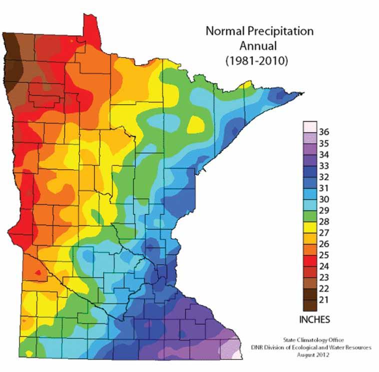
6 Property Information DESCRIPTION: TAX PID #: BUILDINGS: 80 ± Acres. West half of SE¼. Section 29, T110N-R23W (not to be used on legal documents) (Killkenny Township, LeSueur County, Minnesota) R (160 ± ac) Windmill to be removed by seller (not part of sale). Possible well on property. REAL ESTATE TAXES: 2018 Ag Hmstd taxes (160 ± ac) = $3, Special Assessments-Ditch #38 = $ FSA INFORMATION: Total acres = 80 ± acres *FSA Tillable acres = 47 ± acres *Corn base acres = 42.3 ± acres Corn PLC Yield = 168 ± bushels *Wheat base acres = 4.4 ± acres Wheat PLC Yield = 43 ± bushels Farm Program Info - Enrolled into Agricultural Risk Coverage (ARC) County *Estimated acres. This tract is being split from a larger tract. FSA will recalculate tillable and base acres after sale. SOIL DESCRIPTION: Kilkenny, Hamel, Glencoe, Klossner, Muskego. See Soils Map. CPI: Crop Productivity Index = 78.9 TOPOGRAPHY: DRAINAGE: Level to rolling See tile map. NRCS CLASSIFICATIONS ON TILLABLE ACRES: Exempt from conservation compliance provisions. HEL - Highly Erodible Land WINGERT REALTY & LAND SERVICES, INC. stipulates that they are representing the seller exclusively in this transaction. The information gathered for this brochure in its entirety is from sources deemed reliable, but cannot be guaranteed by Seller, Wingert Realty & Land Services, Inc., or its staff. Package is subject to prior sale, price change, correction or withdrawal. The buyer must make their own independent investigation of the property. The buyer is purchasing the property as is.


7 Property Photos Looking north from 450th St. Looking northeast from 450th St. Photos taken 9/2018


8 Property Photos Looking northwest from 450th St. Looking west from 450th St.
9 Soils Map
10 Soil Descriptions KILKENNY SERIES - Soil # 238C2, 238B, 238D2 The Kilkenny series consists of very deep, moderately well drained soils that formed in a mantle of clayey glacial till or flow till and underlying loamy glacial till on moraines. These soils have moderately slow permeability. Their slopes range from 2 to 35 percent. The mean annual precipitation is about 28 inches. Mean annual temperature is about 48 degrees F. TYPICAL PEDON: Kilkenny loam with a 15 percent linear sideslope on a glacial moraine in a pastured field. GEOGRAPHIC SETTING: Kilkenny soils have plane and convex slopes on gently sloping to steep end moraines of the Des Moines lobe of the Late Wisconsinan glaciation. Their slopes range from 2 to 35 percent. They formed in a mantle of clayey glacial till or flow till and underlying loamy glacial till on moraines. Mean annual temperature ranges from 45 to 52 degrees F. Mean annual precipitation is about 25 to 32 inches. Frost-free days range from 145 to 175. Elevation above sea level ranges from 800 to 1500 feet. GEOGRAPHICALLY ASSOCIATED SOILS: These are the Glencoe, Lerdal, Lester, Le Sueur, Lura, Mazaska, and Shields series. The very poorly drained Glencoe and Lura soils are in the lower lying drainageways and depressions. The somewhat poorly drained Lerdal soils are on gently sloping to moderately steep areas. Shields soils are poorly drained, and are on slightly elevated flats. Mazaska soils are poorly drained, and are on slightly elevated flats and swales above or within areas of Kilkenny soils. Also, the well drained Lester soils and the moderately well drained Le Sueur soils are associated in a few areas. DRAINAGE AND PERMEABILITY: Moderately well drained. Permeability is moderately slow. Runoff is medium or rapid. A perched seasonal high water table occurs at depths of 2.5 to 3.5 feet during the period November to June in most years. HAMEL SERIES - Soil # 414 The Hamel series consists of very deep, poorly drained soils that formed in slope colluvium and glacial till on moraines. These soils have moderately slow permeability. Their slopes range from 0 to 4 percent. Mean annual precipitation is about 28 inches. Mean annual temperature is about 47 degrees F. TYPICAL PEDON: Hamel loam with a 2 percent concave slope on a glacial moraine in a cultivated field. GEOGRAPHIC SETTING: Hamel soils have concave slopes in swales, rims of closed depressions, foot and toe slopes, and upper drainageways below sloping to very steep slopes. Slope gradients are 0 to 4 percent. Hamel soils formed in slope colluvium and glacial till of Late Wisconsinan Age. Mean annual temperature is about 45 to 48 degrees F. Mean annual precipitation is about 25 to 30 inches. Frost free days range from 125 to 165. Elevation above sea level ranges from 700 to 1600 feet. GEOGRAPHICALLY ASSOCIATED SOILS: These are principally the Hayden and Lester soils. These soils are well drained and are on the higher lying, gently sloping to very steep slopes. DRAINAGE AND PERMEABILITY: Poorly drained. Surface runoff is low or moderately low. Permeability is moderately slow. The apparent seasonal high water table is at.5 to 1.5 feet during November to June in most years. GLENCOE SERIES - Soil # 114 The Glencoe series consists of very deep, very poorly drained soils that formed in loamy sediments from glacial till on glacial moraines. These soils have moderate or moderately slow permeability. Slopes are 0 to 1 percent. Mean annual precipitation is about 28 inches. Mean annual temperature is about 48 degrees F. TYPICAL PEDON: Glencoe clay loam with a concave slope of less than 1 percent in a depression on a ground moraine in cultivated field. GEOGRAPHIC SETTING: Glencoe soils typically are in closed depressions or low gradient swales within the Des Moines lobe of the Late Wisconsinan glaciation. The Glencoe soils are formed in loamy alluvial sediments and loamy glacial till. Mean annual temperature ranges from 45 to 52 degrees F. Mean annual precipitation ranges from 25 to 32 inches. The frost free days range from 124 to 172. The elevation above sea level range from 700 to 1600 feet. GEOGRAPHICALLY ASSOCIATED SOILS: These are the Canisteo, Clarion, Harps, Nicollet, and Webster soils. The well drained Clarion soils are on the sloping uplands. Somewhat poorly drained Nicollet and the poorly drained Canisteo, Webster, and Harps soils are on nearly level to gently undulating slopes. All the above have mollic epipedons less than 24 inches thick. In addition, the Canisteo and Harps soils contain free carbonates throughout. The Glencoe soils also are associated with the Hayden and Lester soils and their
11 Soil Descriptions respective topographic associates in some places. DRAINAGE AND PERMEABILITY: Very poorly drained. Surface runoff is very slow or ponded. Permeability is moderate or moderately slow. KLOSSNER SERIES - Soil # 539 The Klossner series consists of very deep, very poorly drained soils formed in well decomposed organic material 16 to 50 inches thick overlying loamy deposits on moraines, till plains, lake plains, outwash plains, flood plains, and hillside seep areas. They have moderately slow to moderately rapid permeability in the organic material, and moderate or moderately slow permeability in the loamy material. Slopes range from 0 to 8 percent. Mean annual precipitation is about 28 inches. Mean annual temperature is about 47 degrees F. TYPICAL PEDON: Klossner muck - with a 1 percent slope in a cultivated field. GEOGRAPHIC SETTING: Klossner soils are in basins that were formerly lakes or ponds, lake plains, till plains, flood plains, outwash plains, or moraines. They are also on hillside seep areas in moraines and sideslopes of river valleys. Slopes range from 0 to 8 percent. The soils on nearby uplands are generally loamy. The mean annual temperature ranges from 45 to 50 degrees F. The mean annual precipitation ranges from 24 to 32 inches. Frost free days range from 110 to 160. Elevations above sea level range from 800 to 1400 feet. GEOGRAPHICALLY ASSOCIATED SOILS: The main ones are the Canisteo, Harps, Okoboji, Glencoe, Muskego and Houghton soils. Canisteo and Harps soils are on the rims of depressions. Glencoe and Okoboji are at the outer edges of the depressions. Muskego and Houghton soils are in larger depressions. DRAINAGE AND PERMEABILITY: Very poorly drained. Surface runoff is very slow or ponded. Permeability is moderately slow to moderately rapid in the organic layers and moderate or moderately slow in the loamy material. permeability in the coprogenous material. Slopes range from 0 to 2 percent. Mean annual precipitation is about 30 inches near the typical pedon site. Mean annual temperature is about 49 degrees F. typical pedon site. Mean annual temperature is about 49 degrees F. TAXONOMIC CLASS: Coprogenous, euic, mesic Limnic Medisaprists TYPICAL PEDON: Muskego muck - on a slope of less than 1 percent in a cultivated field at an elevation of about 815 feet. GEOGRAPHIC SETTING: The Muskego soils commonly are in depressional areas principally associated with glacial lake plains and flood plains, but other geographical locations are not excluded. Slope ranges from 0 to 2 percent. These soils formed in herbaceous organic material dominantly from grasses, sedges, and reeds over coprogenous limnic material (sedimentary peat). Mean annual temperature ranges from 46 to 52 degrees F. Mean annual precipitation ranges from 25 to 40 inches. The frost free period ranges from about 130 to 160 days. Elevation ranges from 800 to 1400 feet. GEOGRAPHICALLY ASSOCIATED SOILS: These are the Houghton and Klossner series. Houghton soils are in nearby areas where the organic deposits are more than 51 inches thick and coprogenous material is not in the lower part of the control section. Klossner soils are in areas where the coprogenous material is absent and the herbaceous organic material is underlain by loamy mineral material. DRAINAGE AND PERMEABILITY: Very poorly drained. Runoff is very low or ponded. Permeability is moderate or moderately rapid in the herbaceous sapric material and slow in the coprogenous material (sedimentary peat). Most Muskego soils have an apparent water table from 1 foot above the surface to 1 foot below the surface in most years for much of the period from November to August. Some Muskego soils have an apparent water table from 3 feet to 1 foot above the surface in most years for much of the period from January to December. MUSKEGO SERIES - Soil # 525 The Muskego series consists of very deep, very poorly drained soils formed in herbaceous organic material over coprogenous limnic material (sedimentary peat) on glacial lake plains and flood plains. These soils have moderate or moderately rapid permeability in the herbaceous organic material and slow
12
13
14 SEALED BID AUCTION INSTRUCTIONS Sealed Bid Location and Time: Elysian Tourism Center 100 3rd St SW Elysian MN Tuesday, October 2, 10 a.m. Sealed Bid Instructions: 1. Only registered bidders may attend. Must be registered prior to auction date. All potential bidders shall deliver or mail a sealed bid, postmarked by September 27, 2018 to: Wingert Realty & Land Services, Inc., Attn: Darrell Hylen 1160 Victory Drive So., Suite 6, Mankato, MN If you are unable to get postmarked bid in on time, call our office for other arrangements. 2. All bids must be accompanied by a $5,000 check for earnest money made out to Wingert Realty Trust Account. 3. The written bid shall state the total price for total deeded acres. 4. All persons submitting a written bid will be allowed to raise their bid after all bids have been opened. 5. The premises described herein will be sold in as is, where is condition 6. Seller shall pay the real estate taxes and special assessments due and payable in 2018, and receive 2018 income. 7. Purchaser shall pay the real estate taxes and special assessments due and payable in 2019 and beyond. 8. The successful bidder or bidders will enter into a Purchase Agreement and shall pay as earnest money 10% of the successful bid on the day of auction. 9. A 2% Buyer Premium will be added to the final bid price to arrive at the final contract price. 10. The entire balance of the purchase price, without interest, will be due and payable on Friday, November 9, 2018 at which time marketable title shall be conveyed. Possession takes place after 2018 crop has been removed. 11. All checks will be returned to unsuccessful bidder. 12. The Sellers reserve the right to reject any and all bids and to waive any irregularities in the bidding. 13. Announcements made the day of the auction take precedence over written material. For additional information, contact: Wingert Realty & Land Services, Inc. Darrell Hylen, ALC, Auctioneer # (800) 730-LAND (5263), LAND (5263) or Direct
15 REGISTRATION / BIDDING FORM Bid Submitting Instructions: Write in your total price for total deeded acres for each parcel you would like to bid on Write in your name, address, telephone number and address All bids must be accompanied by a $5,000 check (this check covers any and all parcels you wish to bid on) for earnest money made out to Wingert Realty Trust Account. Only registered bidders may attend. Must be registered prior to auction date. All potential buyers shall deliver or mail a sealed bid, postmarked by September 27, 2018 to: Wingert Realty & Land Services, Inc., Attn: Darrell Hylen 1160 Victory Drive So., Suite 6, Mankato, MN If you are unable to get postmarked bid in on time, call our office for other arrangements. Refer to the Cummiskey Farm brochure for further details concerning bidding procedures. Also available to print online: SUBJECT PROPERTY ACRES 80 ± TOTAL BID AMOUNT (Nearest $1,000) $ NAME: ADDRESS: CITY / STATE / ZIP: CELL PHONE: ( ) /RESIDENTIAL ( ) ADDRESS:
16 WINGERT REALTY & LAND SERVICES, INC. Serving Minnesota and Northern Iowa Mankato Office: Toll Free LAND (5263) Local LAND (5263) CHARLES WINGERT, ALC PAST NATIONAL PRESIDENT OF REALTORS LAND INSTITUTE (2013) Broker Direct Line: DARRELL HYLEN, ALC Real Estate Sales & Lease Negotiation Direct Line: Auctioneer # Auctioneer # DAVID HANSON Real Estate Sales Direct Line: David@WingertRealty.com Auctioneer # Redwood Falls Office: RICHARD HAUGE, ALC & ARA Real Estate Sales & Appraisals Direct Line: Rick@WingertRealty.com Auctioneer # ALL ARE LICENSED MN REALTORS THE LAND REPORT, the magazine of the American Landowner, has named Wingert Realty & Land Services, Inc. America s Best Brokerages and Top Auction Houses in the U.S.A.! 9/12
We are pleased to present Stattelman Trust - Todd County ± Acres Bertha Township, Todd County
 We are pleased to present Stattelman Trust - Todd County 86.90 ± Acres Bertha Township, Todd County SUBJECT PROPERTY This property to be sold by Sealed Bid Auction Owner: Stattelman Trust; Thomas Stattelman,
We are pleased to present Delores Reuter Estate ± Acres Decoria Township, Blue Earth County
 We are pleased to present Delores Reuter Estate 78.48 ± Acres Decoria Township, Blue Earth County This property to be sold by Sealed Bid Auction Owner: Delores Reuter Estate Owner s Attorney: Richard Kakeldey,
We are pleased to present Peter & Arlyss Dirkx Farm 120 ± Acres Sterling Township, Blue Earth County
 We are pleased to present Peter & Arlyss Dirkx Farm 120 ± Acres Sterling Township, Blue Earth County PARCEL 1 PARCEL 2 PARCEL 3 = PARCELS 1+2 This property to be sold by Sealed Bid Auction Owner: Arlyss
We are pleased to present Kingery Farm 144 ± Acres Worthington Township, Nobles County
 We are pleased to present Kingery Farm 144 ± Acres Worthington Township, Nobles County SUBJECT PROPERTY This property to be sold by Sealed Bid Auction Owner: John Kingery, Ann Schlomann and Paula Seep
Purchase Price: $110,000
 We are pleased to present Laumann Property 40 ± Acres Hunting & Recreation Beauford Township, Blue Earth County Subject Property Access Easement Owners: Laumann Family Location: Two one half mile east
We are pleased to present Roland Hammer Children s Trust 80 ± Acres Hantho Township, Lac Qui Parle County
 We are pleased to present Roland Hammer Children s Trust 80 ± Acres Hantho Township, Lac Qui Parle County This property to be sold by Sealed Bid Auction Owner: Roland Hammer Children s Trust - Joe Hammer,
Introduction. Implementation of the Village of Capac Master Plan
 Implementation of the Village of Capac Master Plan Introduction The key to a well-planned community is the actual day-to-day use of planning documents, like this Master Plan. Because this plan is to be
Arrowhead Ranch. Located in the Big Range Country of Central Wyoming.
 Arrowhead Ranch Located in the Big Range Country of Central Wyoming. 58 E. Benteen Street Buffalo, WY 82834 Ph 307-684-9556 Toll Free 888-684-9557 Fax 307-684-8565 Location The ranch is approximately:
HIGH QUALITY FARMLAND PORTFOLIO MONROE COUNTY, ILLINOIS 670 ACRES M/L
 HIGH QUALITY FARMLAND PORTFOLIO MONROE COUNTY, ILLINOIS 670 ACRES M/L HIGH QUALITY FARMLAND PORTFOLIO Monroe County, Illinois 670 Acres M/L Mississippi River St. LOUIS, MISSOURI Monroe CouNTy, Illinois
(Short Listing) DUPUYER ACREAGE, ROCKY MOUNTAN FRONT
 DUPUYER ACREAGE, ROCKY MOUNTAN FRONT") (Short Listing) DUPUYER ACREAGE, ROCKY MOUNTAN FRONT This unique property is located 8½ miles northwest of Dupuyer, Montana and approximately thirty 30 miles northwest of Choteau, Montana. Great Falls
(Short Listing) DUPUYER ACREAGE, ROCKY MOUNTAN FRONT This unique property is located 8½ miles northwest of Dupuyer, Montana and approximately thirty 30 miles northwest of Choteau, Montana. Great Falls
Region 1 Piney Woods
 Region 1 Piney Woods Piney Woods 1. This ecoregion is found in East Texas. 2. Climate: average annual rainfall of 36 to 50 inches is fairly uniformly distributed throughout the year, and humidity and temperatures
2.0 Physical Characteristics
 _ 2.0 Physical Characteristics 2.1 Existing Land Use for the Project The site is comprised of approximately 114 acres bounded by Highway 101 to the north, the existing town of Los Alamos to the east, State
The Needle View Ranch
 The Needle View Ranch Hot Springs County, Wyoming Presented by: 58 E. Benteen Street Buffalo, Wyoming 307-684-9556 or 888-684-9557 SUBJECT The Needle View Ranch is located approximately 14.5 miles northwest
Buffalo Springs Ranch
 Buffalo Springs Ranch Acton, Montana For additional details, contact: SCOTT R. GROSSKOPF Broker / Owner Member Landmark of Billings 1925 Grand Avenue, Ste. 144, Billings, MT 59102 Office: (406) 248-3101
Acres Monterey County, California OPEN GROUND IN SALINAS VALLEY VEGETABLE AND STRAWBERRY PROPERTY
 324 +- Acres Monterey County, California OPEN GROUND IN SALINAS VALLEY VEGETABLE AND STRAWBERRY PROPERTY EXCLUSIVELY PRESENTED BY: Morris Garcia License 00834407 (559) 994-7453 Cell Sarah Donaldson License
Brinker Creek Ranch. Colorado - Routt County - Yampa
 Located at the base of the Flattops Range in the Steamboat/Vail corridor, Brinker Creek Ranch consists of 1,451 acres ideally suited for high country grazing and native grass hay production. Traditionally
Geoscape Toronto The Oak Ridges Moraine Activity 2 - Page 1 of 10 Information Bulletin
 About 13,000 years ago as the Laurentide Ice Sheet melted, glacial meltwater accumulated between the ice sheet and the Niagara Escarpment. This formed a lake basin into which gravel and sand were deposited.
BRANDON PLANTATION Auction
 BRANDON PLANTATION Auction historical virginia landmark plantation // 23500 brandon road // spring grove, VA in conjunction with richard buckingham OF RE/MAX COMMONWEALTH WEDNESDAY, JUNE 26 at noon In
KNIGHTS LANDING RIVER RANCH WOODLAND, CA - YOLO COUNTY
 PROPERTY HIGHLIGHTS ±77.2 Gross Acres Contains Excellent Sandy and Silty Clay Loam Soils Established Surface Water Rights in Sacramento River Developed River Diversion and Distribution System Three Phase
Howard County Land and Home
 Howard County Land and Home A wonderful Howard County property featuring crop land, pasture land, and a nice home. Property Highlights List Price $830,000 $715,000 Location 2087 Merrick Road, Palmer, Nebraska
SALYER LAND COMPANY. Kings and Tulare Counties, California. 1,849.47± Assessed Acres. Exclusively Presented by: Pearson Realty
 Kings and Tulare Counties, California 1,849.47± Assessed Acres F & J Blocks Chandler Ranch Dairy Avenue Ranch Exclusively Presented by: Pearson Realty Offices Serving The Central Valley FRESNO VISALIA
Ranch. Creek. Cow. Mountain
 Cow Creek Mountain Ranch Situated along the southwestern hills of the Laramie Mountains and the Medicine Bow-Routt National Forest in northeastern Albany County, Wyoming. 58 E. Benteen Street Buffalo,
Court Ordered Sale ASKING PRICE 2,950,000. DISTRICT LOT 4501 WESTSIDE ROAD 279 ACRES, LAKE OKANAGAN WATERFRONT Central Okanagan Regional District
 Court Ordered Sale DISTRICT LOT 4501 WESTSIDE ROAD 279 ACRES, LAKE OKANAGAN WATERFRONT Central Okanagan Regional District ASKING PRICE 2,950,000 For more information please contact: Brian Tattrie Vice
BAsin. - Ranch - Offered at $11,500,000.
 BAsin Greenfield, California Offered at $11,500,000 www.clarkcompany.com 1031 Pine Street Paso Robles, California 93446 Phone: (805) 238-7110 Fax: (805) 238-1324 info@clarkcompany.com BAsin Description
What Is An Ecoregion?
 Ecoregions of Texas What Is An Ecoregion? Ecoregion a major ecosystem with distinctive geography, characteristic plants and animals, and ecosystems that receives uniform solar radiation and moisture Sometimes
Gifts of the Glaciers
 Gifts of the Glaciers Gifts of the Glaciers Moving ice of glacier was responsible for water, landforms, and soil characteristics and patterns of today Sculpturing of bedrock materials Glacial Landforms
CABARTON RANCH NORTH EXECUTIVE SUMMARY
 EXECUTIVE SUMMARY O ffering breath-taking scenery and serene privacy, the 705 + acre Cabarton Ranch North is nestled at the base of West Mountain in the southwestern-edge of Valley County, near Lake Cascade,
Cabo Rojo BOQUERON BAY, PUERTO RICO AUCTION JUNE 18 AT 5PM ET
 THE CARIBBEAN BASIN ULTRA LUXURY MULTI-COUNTRY/MULTI-PROPERTY AUCTION PRESENTED BY PREMIERE ESTATES AUCTION COMPANY Cabo Rojo BOQUERON BAY, PUERTO RICO AUCTION JUNE 18 AT 5PM ET THE OPPORTUNITY 340-ACRE
Cabo Rojo BOQUERON BAY, PUERTO RICO AUCTION MAY 14 AT 5PM ET
 THE CARIBBEAN BASIN ULTRA LUXURY MULTI-COUNTRY/MULTI-PROPERTY AUCTION PRESENTED BY PREMIERE ESTATES AUCTION COMPANY Cabo Rojo BOQUERON BAY, PUERTO RICO AUCTION MAY 14 AT 5PM ET BOQUERON BAY SITE THE CONCEPTUAL
124 Blarney Drive Columbia, South Carolina
 For Sale ±2.99 AC Commercial Land Two N otch Rd. Exit 7 Site 24 Blarney Drive Columbia, South Carolina Exclusively Offered By: Tom Milliken O: + 803 744 9837 C: + 803 33 6999 E: tmilliken@naiavant.com
Figure 1 shows the evaluation area around Tailings Basin Cells 2E/1E. Two areas were evaluated for potential wetland impacts including:
 Barr Engineering Company 4700 West 77th Street Minneapolis, MN 55435-4803 Phone: 952-832-2600 Fax: 952-832-2601 www.barr.com An EEO Employer Minneapolis, MN Hibbing, MN Duluth, MN Ann Arbor, MI Jefferson
BUCK POINT RANCH. Aspen Associates Realty
 BUCK POINT RANCH Aspen Associates Realty www.aspenassociatesrealty.com 970.544.5800 WELCOME TO Buck Point Ranch is a 960± acre property located in one of the last pristine valleys in close proximity to
South Willow Creek Musselshell County Montana
 South Willow Creek Musselshell County Montana Clifton M. Berglee, D.V.M. (Listing Broker) 406-860-7319 cell cberglee@montwyowest.com Phone: (406) 628-2341 (office) Website: montwyowest.com P.O. Box 578,
Weston County, Wyoming
 The Sweet 200-Acre Property Weston County, Wyoming A unique opportunity to own a little piece of the old West, where one can experience unparalleled scenery, adventure and history walk in the footsteps
Cooper Jack Marina TURKS & CAICOS ISLANDS PREMIERE AUCTION MAY 21 AT 5PM ET ULTRA LUXURY THE CARIBBEAN BASIN MULTI-COUNTRY/MULTI-PROPERTY AUCTION
 THE CARIBBEAN BASIN ULTRA LUXURY MULTI-COUNTRY/MULTI-PROPERTY AUCTION PRESENTED BY PREMIERE ESTATES AUCTION COMPANY Cooper Jack Marina TURKS & CAICOS ISLANDS PREMIERE AUCTION MAY 21 AT 5PM ET THE OPPORTUNITY
Preliminary Site Evaluation
 Preliminary Site Evaluation 100 Acre Site, US 72 Piperton, Tennessee Power Distributor: Chickasaw Electric Cooperative August 2010 SITE DATA SHEET PIPERTON US 72 SITE (100 ACRES): LOCATION & GENERAL DESCRIPTION
HIGH COUNTRY L-BAR RANCH
 HIGH COUNTRY L-BAR RANCH Sandoval and mckinley counties N e w m e x i c o Jim Haworth, Ranch Team Lead Broker ~ 505-235-5236 3613 NMSR 528 NW, Ste. H, Albuquerque, NM 87114 505-792-3713 www.wwrealty.com
A. Location. Darby Creek Watershed Inventory Final Draft (3/21/2005) 1
 1") I. WATERSHED SETTING The Darby Creek Watershed encompasses about 355,000 acres (555 square miles) and is located just west of the City of Columbus. From its headwaters in Logan County to its confluence
I. WATERSHED SETTING The Darby Creek Watershed encompasses about 355,000 acres (555 square miles) and is located just west of the City of Columbus. From its headwaters in Logan County to its confluence
Big Sandy Ranch Mohave County, Arizona
 Big Sandy Ranch Mohave County, Arizona Photo [9] Deeded land on hillside within the River Ranch parcel Listed for sale exclusively by: Traegen Knight Headquarters West Ltd. PO BOX 1980 St. Johns, AZ 85936
FOR SALE OR LEASE. St. Croix Meadows Redevelopment LOTS FOR SALE. Hudson, WI
 St. Croix Meadows Redevelopment EXIT RAMP EXISTING OVERPASS VACATE R.O.W. CARMICHAEL RD ON RAMP HIGH-TECH/FLEX SPACE MEDICAL OFFICE - 20K SF EACH RETAIL / ENTERTAINMENT 24-46K SF FULL ACCESS CORPORATE
1947 Noyestar Road, Walden, VT
 1947 Noyestar Road, Walden, VT Curtis Trousdale, Owner, Broker, Realtor Cell: 802-233-5589 curtis@preferredpropertiesvt.com 2004 Williston Road, South Burlington VT 05403 www.preferredpropertiesvt.com
Level IV Ecoregions of the Northeast Glacial Lakes Watershed Project Area
 Level IV Ecoregions of the Northeast Glacial Lakes Watershed Project Area Ecoregions are areas having similar ecosystems and environmental resources including geology, physiography, vegetation, climate,
Topographic Maps. Background Sheet
 Topographic Maps History: Background heet The Articles of Confederation (1777) was ratified when western lands were yielded to the Federal Government. This yielding of land gave the Federal Government
2015 Brain Wrinkles. SS8G1b
 SS8G1b Georgia is a geographically diverse state that is divided into five regions. The first three regions (Appalachian Plateau, Valley and Ridge, and Blue Ridge) are in the mountains and foothills of
REGULATIONS FOR DECLARATION AND DISPOSAL OF UNCLAIMED ITEMS OF THE PIRAEUS CONTAINER TERMINAL S.A. IN THE PIRAEUS FREE ZONE
 REGULATIONS FOR DECLARATION AND DISPOSAL OF UNCLAIMED ITEMS OF THE PIRAEUS CONTAINER TERMINAL S.A. IN THE PIRAEUS FREE ZONE Article 1 Goods declared unclaimed deadlines Goods unloaded and received by the
Subject to sale, withdrawal, or error.
 The Crawford L Bar Ranch is located approximately 40 air miles west of Albuquerque, New Mexico. This ranch truly epitomizes the description of New Mexico being the Land of Enchantment. The topography and
Ditch flows slowly to the north
 Ditch flows slowly to the north Photo 1. Wetland DE: Looking west across Wetland DE from upslope. Ponded water, mucky mineral soils, and patches of emergent vegetation observed. Wetland DE appears to be
Glacial Geomorphology Exercise
 James Madison University Field Course in western Ireland Glacial Geomorphology Exercise 3-day road log (abbreviated) Striations Large kame terrace Cirque with moraines Kame delta Striations Eskers Raised
Skyland Ranch. At a Glance: Property Features
 Property Features Ideally positioned in an ox box of the mighty Apalachicola River, Skyland Ranch s 2 ½ miles of river frontage form the foundation of this distinctive property. Coveted by recreational
566± acres total - WILL DIVIDE Volusia County, FL
 L IC E N S E D HUNTING P RESERVE ts Q u a i l ahi ul anb l e are av r info! fo CALL TODAY LAKEFRONT PROPERTY PERFECTION This ranch lies on a natural sand ridge in North Volusia County, Florida and has
House, Buildings & 4.56 Acres m/l Linn County, IA Old Quaas Road, Alburnett, Iowa 52202
 HOUSE FOR SALE House, Buildings & 4.56 Acres m/l Linn County, IA 2713 Old Quaas Road, Alburnett, Iowa 52202 Property Information Location From Alburnett: ½ South on Alburnett Road and ½ west on Old Quaas
SECTION 3 GENERAL DESCRIPTION OF THE RIVER BASIN
 SECTION 3 GENERAL DESCRIPTION OF THE RIVER BASIN SECTION 3 GENERAL DESCRIPTION OF THE RIVER BASIN River basin description. A general description of the river basin or subbasin, as appropriate, in which
Blanco Creek Ranch Acres, Uvalde County, Texas
 Blanco Creek Ranch 1208.30 Acres, Uvalde County, Texas James King, Agent Office 432 426.2024 Cell 432 386.2821 James@KingLandWater.com Blanco Creek Ranch 1208.30 acres Uvalde County, Texas James King,
520± Acre. Las Aldeas Farm. Imperial Valley, CA. agribusiness solutions team. Curtis Buono CA Lic.
 520± Acre Las Aldeas Farm Imperial Valley, CA agribusiness solutions team Curtis Buono 858.558.5629 curtis.buono@cushwake.com CA Lic. #1894905 Matt Davis 858.334.4026 matt.davis@cushwake.com CA Lic. #1758818
RAY YENKANA Willowbrook Cr, Dawson Creek BC Canada $2,847,000
 1716 Willowbrook Cr, Dawson Creek BC Canada For SALE $2,847,000 This is a rare find, 32 townhomes in Dawson Creek, BC. Excellent investment in a single title multi family complex. Vendor has upgraded this
NM or AZ Cell Fax at:
 For Sale Exclusively Offered By Azure Enterprises, Inc. P.O. Box 880 Las Vegas, New Mexico 87701 505.454.6000 NM or 480-535-4800 AZ Cell 505-429-0039 Fax 480-295-7997 Email at: lwbrow@gmail.com Forward
GLACIATION. The Last Ice Age (see Chapter 12) and. Pleistocene Ice Cap. Glacial Dynamics 10/2/2012. Laurentide Ice Sheet over NYS
 and. Pleistocene Ice Cap. Glacial Dynamics 10/2/2012. Laurentide Ice Sheet over NYS") GLACIATION and New York State Prof. Anthony Grande The Last Ice Age (see Chapter 1) The Pleistocene Epoch began 1.6 mya. During this time, climates grew colder. There were numerous ice ages starting 100,000000
GLACIATION and New York State Prof. Anthony Grande The Last Ice Age (see Chapter 1) The Pleistocene Epoch began 1.6 mya. During this time, climates grew colder. There were numerous ice ages starting 100,000000
HYDROLOGY OF GLACIAL LAKES, FORT SISSETON AREA
 PROC. S.D. ACAD. SCI., VOL. 77 (1998) 59 HYDROLOGY OF GLACIAL LAKES, FORT SISSETON AREA Perry H. Rahn Department of Geology & Geological Engineering South Dakota School of Mines and Technology Rapid City,
Boise Municipal Code. Chapter DEFINITIONS
 Chapter 12-03 DEFINITIONS Sections: 12-03-01 ADMINISTRATOR 12-03-02 AIRPORT DESIGNATIONS 12-03-03 AIRPORT HAZARD 12-03-04 AIRPORT HEIGHT LIMITATIONS 12-03-05 AIRPORT REFERENCE POINT 12-03-06 AIRPORT INSTRUMENT
Philip, SD Haakon County 370 Acres $475,000
 Philip, SD Haakon County 370 Acres $475,000 The Powell Rd. West property boasts of richly grassed and brushy draws and fertile meadows. This diverse and attractive ranch and recreational property affords
8. Agricultural, Natural and Cultural Resources
 8. Agricultural, Natural and Cultural Resources Agriculture Agriculture is still a prevalent land use in the Town of Medary. Increased housing development has caused a decrease in farmland over the last
Crown Lands and Property Agency. Name Client # LAST (Please Print) FIRST MIDDLE (no initials) Mailing Address. Postal Code
 FIRST MIDDLE (no initials) Mailing Address. Postal Code") Manitoba Conservation and Water Stewardship Application for Permit/Lease/Purchase/Easement/Exchange/Licence of Occupation (under The Crown Lands Act c.c340) Please check one ( ) Permit Lease Purchase Easement
Manitoba Conservation and Water Stewardship Application for Permit/Lease/Purchase/Easement/Exchange/Licence of Occupation (under The Crown Lands Act c.c340) Please check one ( ) Permit Lease Purchase Easement
Rule Governing the Designation and Establishment of All-Terrain Vehicle Use Trails on State Land
 Rule Governing the Designation and Establishment of All-Terrain Vehicle Use Trails on State Land 1.0 Authority 1.1 This rule is promulgated pursuant to 23 V.S.A. 3506. Section 3506 (b)(4) states that an
FOR SALE. 2 Okanagan Self-Storage Facilities. Okanagan Valley, British Columbia. Two storage facilities offered separately or as a package:
 2 Okanagan Self-Storage Facilities Okanagan Valley, British Columbia FOR SALE Penticton, BC Vernon, BC Asking Price: $630,000 Two storage facilities offered separately or as a package: Vernon Mini-Storage,
Roduner Ranch FOR SALE. 5,878± Acres Potential Development Land. Merced County, California. Offices Serving The Central Valley
 FOR SALE 5,878± Acres Potential Development Land Merced County, California Offices Serving The Central Valley F R E S N O V I S A L I A B A K E R S F I E L D 7480 N. Palm Ave, Ste 101 3447 S. Demaree Street
The Northeast: America's Gateway to the World
 The Northeast: America's Gateway to the World Living in the Shadow of the Ice a lesson on the impact of glaciation on Northeast landscapes INTRODUCTION: The region we call the Northeast has a very long
Meadow Creek and Goat Creek pass through Goat Falls Ranch & Alpine Peak
 Henri W. LeMoyne 1346 Fillmore Street Post Office Box 5225 Phone: (208) 733-0874 Fax: (208) 733-8475 E-mail: henri@lemoynerealty.com Twin Falls, Idaho 83303-5225 Location: The Goat Falls Ranch is located
AGRICULTURAL LAND ±197 AC HENRY MILLER RD, LOS BANOS, CA 93635
 Turner Island Rd, MERCED COUNTY Santa Fe Grade SITE CONTACT US RANDY GRIMSMAN Senior Vice President +1 916 446 8745 randall.grimsman@cbre.com www.cbre.com/randall.grimsman Lic. 00857338 CBRE, Inc. 500
STUCKIVOULICH TARBET
 STUCKIVOULICH TARBET STUCKIVOULICH, TARBET G83 7DQ Rarely available detached country house close to Loch Lomond with separate converted coach house in about 10 acres. Tarbet 1 mile. Arrochar 3 miles.
BRIEF OVERVIEW ORLANDO NORTH AIRPARK ENTERPRISE ZONE
 BRIEF OVERVIEW ORLANDO NORTH AIRPARK ENTERPRISE ZONE The Orlando North Airpark Enterprise Zone is a rare opportunity for any company desiring to relocate or open a new operation in the State of Florida.
3.0 OVERVIEW OF HUECO BOLSON
 3.0 OVERVIEW OF HUECO BOLSON The Hueco Bolson covers about 2,500 square miles, or 1.6 million acres in New Mexico, Texas, and Chihuahua (Figure 3-1). In Texas, the Hueco overlies portions of El Paso and
Morgan Estates. Lassen County, CA. Proudly Offered By
 Morgan Estates Lassen County, CA Proudly Offered By 707 Merchant Street, Suite 100, Vacaville, Ca 95688 (707) 455-4444 Office (707) 455-0455 Fax info@caoutdoorproperties.com Introduction Looking North
Morning Copse near Maidstone, Kent acres of Ancient Woodland with a pond, bluebells and mature oak. 26,500 (freehold)
") WOODS 4 SALE Phone: 01248 364 362 www.woods4sale.co.uk UK Woodland & Woods For Sale: Specialising in the Sales of Small Woodlands in England, Scotland and Wales for Recreation, Wildlife Conservation and
WOODS 4 SALE Phone: 01248 364 362 www.woods4sale.co.uk UK Woodland & Woods For Sale: Specialising in the Sales of Small Woodlands in England, Scotland and Wales for Recreation, Wildlife Conservation and
2.1 Physical and Biological Description Matabitchuan River Watershed
 2.1 Physical and Biological Description Watershed 2.1.1 Physical Description The system watershed has a total area of about 933 km 2 and is a tributary system to Lake Temiskaming and the Ottawa River Drainage
Panoramic Views ~11,800 SF Lodge Office & Barns Borders to Mark Twain National Forest. Contact RE Bid Sales for Property & Auction Info, Terms, Etc.
 ELK MOUNTAIN RANCH: For Immediate Sale 800 ACRES WITH LODGE SHANNON COUNTY, MO BUY NOW: Bidding Open, Sellers May Sell Immediately LIVE AUCTION: Feb. 7, 2014 Panoramic Views ~11,800 SF Lodge Office & Barns
PHYSICAL GEOGRAPHY GEOGRAPHY EARTH SYSTEMS COASTAL SYSTEMS FLUVIAL SYSTEMS
 PHYSICAL GEOGRAPHY EARTH SYSTEMS FLUVIAL SYSTEMS COASTAL SYSTEMS PHYSICAL GEOGRAPHY CORRIES / CIRQUES A Corrie or Cirque is the armchair shaped hollow that was the birthplace of a glacier. It has steep,
AUCTION BIDDING You may bid online during the auctions at www. LIVE ONLINE PORTFOLIO OVERVIEW
 PORTFOLIO OVERVIEW STATE COUNTY/ PARISH ACRES CROPLAND (FSA) AUCTION DATE Illinois Mercer 4,869± 4,657± Illinois Fulton 3,769± 3,596± December 12 Texas Hartley 11,240± Texas Moore 920± 11,646± December
THE GHOST ROSE RANCH. Randy J. Wood Qualifying Broker Cell:
 Wild West Properties, LLC 7020 Santa Marisa, NE Albuquerque, NM 87113 505-836-4558 http://www.wildwestproperties.com/ Randy J. Wood Qualifying Broker Cell: 505-980-8019 E-mail: rjwood5@comcast.net THE
INTRODUCTION. Mailing address: Burke County Community Development Attn: Tim Johnson P. O. Box 219 Morganton, NC
 REQUEST FOR QUALIFICATIONS: PROFESSIONAL, EXPERIENCED TRAIL BUILDERS FOR THE CONSTRUCTION OF THE FONTA FLORA STATE TRAIL LAKE JAMES SECTION BURKE COUNTY COMMUNITY DEVELOPMENT INTRODUCTION Burke County
Section 2 North Slope Ecoregions and Climate Scenarios
 Section 2 North Slope Ecoregions and Climate Scenarios North Slope Ecoregions The geographic/ecological scope of the workshop will be freshwater and terrestrial systems of the North Slope of Alaska, with
2015 Brain Wrinkles. SS8G1b
 SS8G1b Standards SS8G1 The student will describe Georgia with regard to physical features and location. b. Describe the five geographic regions of Georgia; include the Blue Ridge Mountains, Valley and
Frizzell Creek Ranch Summerville, OR $1,400, ± Acres
 Frizzell Creek Ranch Summerville, OR $1,400,000 165± Acres 1 Introduction The Frizzell Creek Ranch is a beautiful 165± acre ranch located in northeast Oregon at the base of the Wallowa Whitman National
B HALL RANCH FISHTAIL, MONTANA
 Brochure Courtesy of: B HALL RANCH FISHTAIL, MONTANA w w w. m c c a s l i n l a n d. c o m Page 1 LOCATION The Hall Ranch is ideally located in the foothills of the Beartooth Mountains, approximately 5
EAST COCALICO TOWNSHIP BOARD OF SUPERVISORS MEETING AGENDA
 EAST COCALICO TOWNSHIP AGENDA HELD AT EAST COCALICO TOWNSHIP, 100 HILL ROAD, DENVER, PA 17517 at 7:30 P.M. MEETING CALLED TO ORDER AT 7:30 P.M. FARMLAND TRUST PROJECT PRESENTATION BY STEPHANIE ARMPRIESTER
St. Croix Savanna SNA
 N44 59.954 W92 46.946 N44 59.906 Na ve Plant Communi es* Dry Sand - Gravel Oak Savanna (Southern) * Source: Minnesota Biological Survey N44 59.673 W92 46.734 N44 59.754 W92 46.748 National Wetlands Inventory
The Physical Geography of Long Island
 The Physical Geography of Long Island A Bit About Long Island Length 118 miles Brooklyn to Montauk Geo202 Spring 2012 Width 23 miles at it s widest Area 1,400 square miles Formation of Long Island River
Site Location. Site Location. Renville. Renville County. County. Sacred Heart Township. Chippewa. Kandiyohi. Yellow Medicine.
 M I N N E S O T A T117N Chippewa T117N R37 Sec 15 T117N Kandiyohi Sec 16 Site Location Sec 14 T114N R37 W ) 61 Sec 13 T116N R37W 565 12 Sec 22 Sec 23 Sec 24 565 10 565 11 Sec 21 )58 Sec 28 565 19 T114N
Greenfield Lodge Farm, Strixton, Northamptonshire
 Greenfield Lodge Farm, Strixton, Northamptonshire Greenfield Lodge Farm Strixton, Northamptonshire NN29 7PB An exceptionally well presented arable farm of about 1,035.05 acres (418.88 ha) predominantly
MSK HIGHWAY 80 & DEAN FOREST RD PRICING: $649,000. Commercial Parcel. Chuck Mitchell (912)
") PARCEL SIZE: ±6.620 acres. HIGHWAY 80 & DEAN FOREST RD Commercial Parcel ZONING: C-2-A Garden City, GA. The purpose of the C-2-A district is to create and protect areas in which heavy commercial and certain
PARCEL SIZE: ±6.620 acres. HIGHWAY 80 & DEAN FOREST RD Commercial Parcel ZONING: C-2-A Garden City, GA. The purpose of the C-2-A district is to create and protect areas in which heavy commercial and certain
Berg Ridge BERG RIDGE 1
 Berg Ridge BERG RIDGE 1 Berg Ridge: $13,650,000 ($75,000 / ERU) Jordanelle Basin Wasatch County, Utah LOCATION: North Central Utah in the Jordanelle Basin of Wasatch County a 45-minute drive from downtown
Appendix B-1 Gila National Forest TMP Roads
 Appendix B-1 Gila National Forest TMP Roads This page intentionally left blank. Gila NF TMP Alternative G Roads Identified for AIP Access Common Name (USFS/EPE) Underlying Ownership Miles 107 USFS 0.16
Lidar Imagery Reveals Maine's Land Surface in Unprecedented Detail
 Maine Geologic Facts and Localities December, 2011 Lidar Imagery Reveals Maine's Land Surface in Unprecedented Detail Text by Woodrow Thompson, Department of Agriculture, Conservation & Forestry 1 Introduction
Environment and Natural Resources Trust Fund (ENRTF) M.L ENRTF Work Plan (Main Document)
 M.L ENRTF Work Plan (Main Document)") Environment and Natural Resources Trust Fund (ENRTF) M.L. 2018 ENRTF Work Plan (Main Document) Today s Date: December 8, 2017 Date of Next Status Update Report: January 31, 2019 Date of Work Plan Approval:
Environment and Natural Resources Trust Fund (ENRTF) M.L. 2018 ENRTF Work Plan (Main Document) Today s Date: December 8, 2017 Date of Next Status Update Report: January 31, 2019 Date of Work Plan Approval:
Town of Oakfield Agricultural and Farmland Protection Plan
 SECTION III COMMUNITY OVERVIEW A. Regional Setting / Location The Town of Oakfield is located in the northwestern portion of Genesee County. Located west of New York's Finger Lakes, the Town is uniquely
SS8G1 The student will describe Georgia with regard to physical features and location.
 SS8G1ab Standards SS8G1 The student will describe Georgia with regard to physical features and location. a. Locate Georgia in relation to the region, nation, continent, and hemispheres. b. Describe the
R E P O R T A N D R E M I T T A N C E D U E N O V E M B E R 1
 INSTRUCTIONS FOR BUSINESS REPORTING AND REMITTING OF UNCLAIMED PROPERTY R E P O R T A N D R E M I T T A N C E D U E N O V E M B E R 1 Y O U N G B O O Z E R, T R E A S U R E R A L A B A M A U N C L A I
1.4 Understand how moving ice acts as an agent of erosion and deposition. (Chap. 2)
") 1.4 Understand how moving ice acts as an agent of erosion and deposition. (Chap. 2) There are two types of glaciation. Alpine Glaciation Continental Glaciation Distinguish between the terms alpine glaciation
1.4 Understand how moving ice acts as an agent of erosion and deposition. (Chap. 2) There are two types of glaciation. Alpine Glaciation Continental Glaciation Distinguish between the terms alpine glaciation
THE ALBERTA GAZETTE, SEPTEMBER
 VILLAGE OF CEREAL Order No. 16915 IN THE MATTER OF THE "Municipal Government Act": File No. 241(A)3 AND IN THE MATTER OF an application by the Council of the Village of Cereal, in the Province of Alberta,
5 Acres of Commercial Land - Los Banos, CA
 5 Acres of Commercial Land - Los Banos, CA Hwy 152 Major Credit All or Part $2,300,000 Subject Property Renz & Renz George L. Renz, CCIM george@renzrenz.com 408.846.1031 Summary of Salients 5 Acres of
Public Notice ISSUED: December 10, 2018 EXPIRES: January 9, 2019
 APPLICANT: REFER TO: St. Louis and Lake Counties Regional Rail Authority 2018-01942-ARC Public Notice ISSUED: December 10, 2018 EXPIRES: January 9, 2019 SECTION:404 - Clean Water Act 1. APPLICATION FOR