Hornsby station to Crosslands
|
|
|
- Geoffrey Gibson
- 5 years ago
- Views:
Transcription


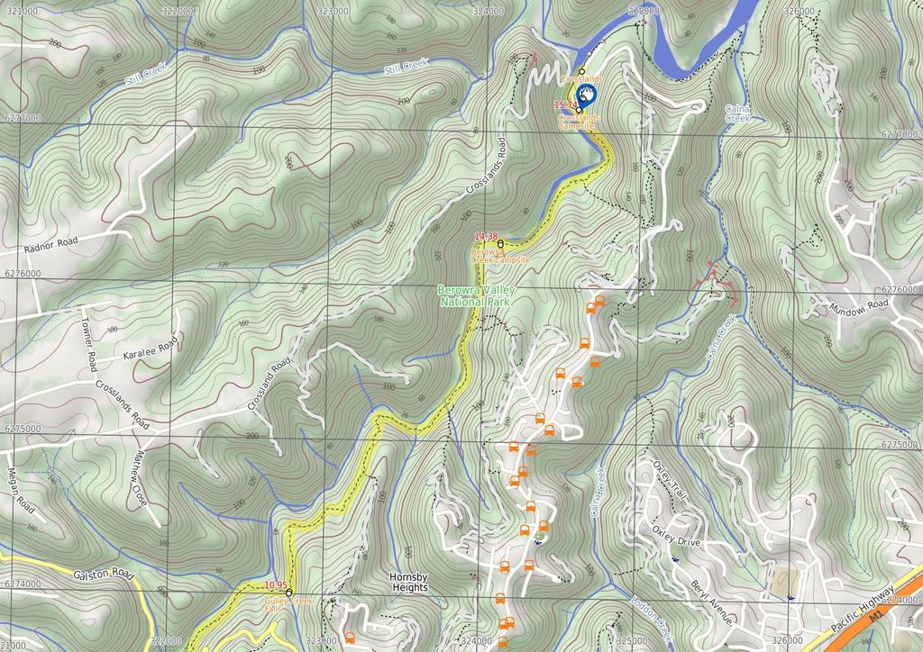
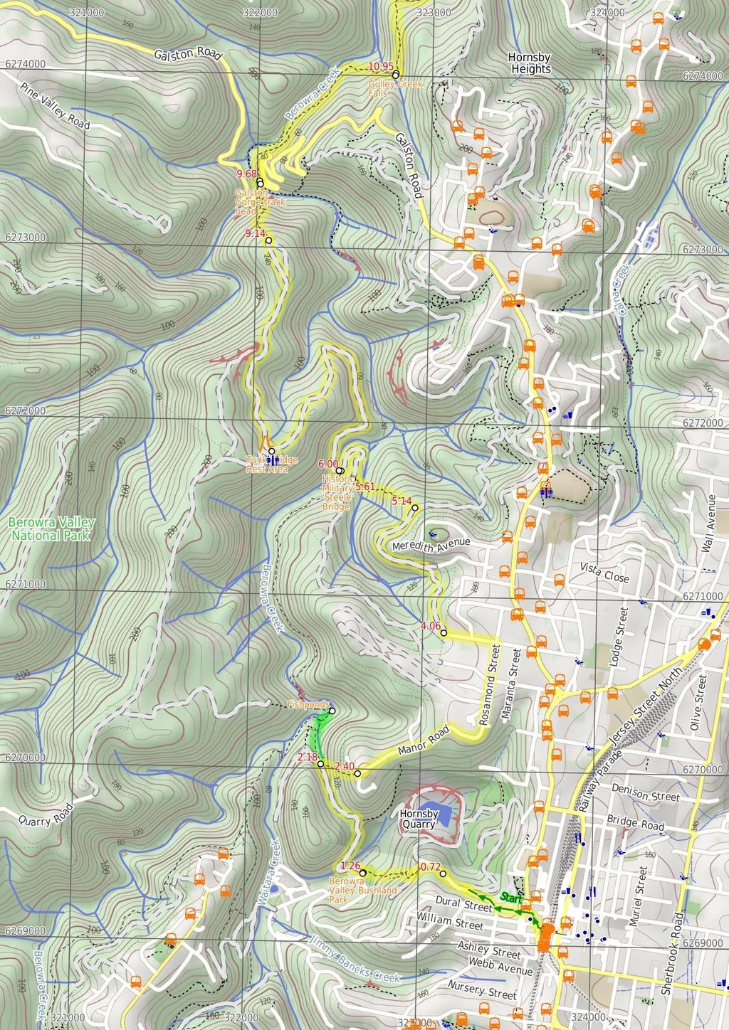
1 Hornsby station to Crosslands 6 hrs 45 mins 16.1 km One way Hard track 4 938m This section of the Great North Walk starts from Hornsby train station and winds down along the Blue Gum Walk into Fishponds. Enjoy the wonderful water hole at fishponds before continuing along Berowra Creek, passing through the Tunks Ridge Reserve and into Galston Gorge. From the Gorge the track keeps following the Berowra Creek past a waterfall to the Crosslands Campsite. People can drive down to Crosslands to pick you up at the end of the walk, or organise a taxi. Check the info at the end of the walk for crosslands closing times. Note this walk was re-routed in early 2016 to go via the streets of Hornsby Heights. This re-route is due to the multi-agency decision to close the Fishponds to Steele Bridge section of the Benowie Track. This decision has upset many people and the protest continues. 193m 1m Berowra Valley National Park Maps, text & images are copyright wildwalks.com Thanks to OSM, NASA and others for data used to generate some map layers.

2 Berowra Valley Bushland Park Before You walk 'Berowra Valley Bushland Park' is also known as Rosemead Rd Park and is found at the bottom end of Rosemead Rd, Hornsby. This is an open area park surrounded by shady eucalyptus trees, making a pleasant spot to rest on a walk. It has a picnic table with bench seats, and a sheltered free electric BBQ. There is a water tap in the park, near the road. There is also a 'Welcome to Old Mans Valley' information sign with information about the traditional country of the Darug and Guringai peoples. Bushwalking is fun and a wonderful way to enjoy our natural places. Sometimes things go bad, with a bit of planning you can increase your chance of having an ejoyable and safer walk. Before setting off on your walk check Fishponds Fishponds is a long waterhole on Berowra Creek in Berowra Valley Regional Park. The waterhole is lined with tall cliffs and a few sandstone caves. At the southern end, there are stepping stones to help cross the creek, and a small timber bridge at the northern end. This is a beautiful spot and a worthy place to rest and enjoy the water passing by. The waterhole is fairly popular with local teens in summer, cooling off. Swimming and jumping at the Fishponds waterhole has resulted in fatalities - please heed the signs and Cora's parents' plea and enjoy the water from the edge. Historic Military 'Steele' Bridge This large steel and timber bridge spans Berowra Creek north of Fishponds. The creek is fairly wide at this point and the bridge provides a great view of the sandstone overhangs along the creek's edge. The bridge was commissioned in 1965 to allow access for fire trucks. The bridge was designed by Major General Sir Clive Steele in Bridges of this type were critical during the WWII South West Pacific campaigns. The bridge is designed on the Warren truss style and is one of only 4 'Steele' bridges still in use in NSW. More info. Tunks Ridge Rest Area Tunks Ridge Rest Area is a large, shady and gently sloping campsite at the junction of three management trails. There is no water or other facilities (you will need to carry your own in). A sign at the top of the campsite reminds campers that there is a one night limit and that it is a fuel stove only area (no campfires). Please note that the composting toilet has been removed and no longer available. Galston Gorge track head Galston Gorge track head is located at a small car park on the eastern side of Berowra Creek, near the bottom of the gorge on Galston Road. This track head is a good access point for those wanting to do sections of the Great North Walk and is well signposted. Keep an eye open for the local chickens. 1) Weather Forecast (BOM Metropolitan District) 2) Fire Dangers (Greater Sydney Region) 3) Park Alerts (Berowra Valley National Park) 4) Research the walk to check your party has the skills, fitness and equipment required 5) Agree to stay as a group and not leave anyone to walk solo Think before you TREK The 'Think before you TREK' program developed by NSW Police & NPWS promotes the benefits of planning ahead for your bushwalking trip by using an easy to remember acronym: adequate supplies of food, water, navigation and first T Take aid equipment. your planned route and tell friends and family when R Register you expect to return. beacon (PLB's) should be carried on walks with E Emergency significant gaps in mobile coverage (check terrain profile). to your planned route and follow the map and walking K Keep trails. Topo Maps The maps provided on wildwalks are helpful, but there are times where you may need maps covering a broader area. Maps that cover this walk include; 1: Map Series:91304S HORNSBY 1: Map Series:9130 SYDNEY Grade This walk has been graded using the AS The overall grade of the walk is dertermined by the highest classification along the whole track. 4 Grade 4/6 Hard track Length 16.1 km One way Time 6 hrs 45 mins Quality of track Rough track, where fallen trees and other obstacles are likely (4/6) Signs Directional signs along the way (3/6) Experience Required Some bushwalking experience recommended (3/6) Weather Weather generally has little impact on safety (1/6) Infrastructure Limited facilities, not all cliffs are fenced (3/6)
3 Are you ready to have fun? Please ensure you and your group are well prepared and equipped for all possible hazards and delays. Check park closures, weather information and Fire Danger Rating before setting out. Optional side trips and alternate routes noted are not included in this walks overall grade, length or time estimate. Please allow extra time for resting and exploring areas of interest. The authors, staff and owners of wildwalks take care in preparing this information but will not accept responsibility for any inconvenience, loss or injury you may experience. Please take care, have fun - Happy Walking. Getting there You can get to Hornsby Train Station (gps: , ) by car, train or bus. Car: There is free parking available. Traveling by car is the only practical way to get back from Crosslands Carpark (gps: , ). Car: There is free parking available. Find up to date and more information inlcuding; travel directions, weather, park closures and walker feedback at 0 Hornsby Train Station (720 m 14 mins) From the western side of Hornsby Railway Station, this walk first crosses the bus lane, then follows the large 'To the Great North Walk' sign across the Station St pedestrian crossing, and then across the Pacific Highway at the traffic lights. Here the walk turns right and follows the footpath (across 'Dural Lane') past some shops to cross 'Dural St'. The walk then turns left and follows the footpath down along 'Dural St', past a few more shops. Continuing past the units, this walk then turns right onto 'Quarry Rd' and follows the road down the gently hill for about 180m to an intersection with 'Old Mans Valley' management trail and locked gate (on your right). Continue straight: From the intersection, this walk follows Quarry Road down the gentle hill, leaving the houses behind to come to an intersection with a track, signposted with a 'Great North Walk' sign (on your left) Int of Quarry Road and GNW (540 m 14 mins) Turn left: From the intersection, this walk follows the 'Great North Walk' sign up the hill. The track leads up over the rise, then continues down to the intersection with the Quarry Rd Management trail. Continue straight: From the intersection, this walk follows the 'Great North Walk' sign down the steep rock steps. The walk winds steeply down a number of sets of stone steps, passing some large rock walls for a bit over 100m, to find a welcome flat section of track midway the hill. As the track leads past some houses (through the trees on your left), this walk heads down more steps before coming to the open area of 'Berowra Valley Bushland Park', at the end of Rosemead Road Berowra Valley Bushland Park 'Berowra Valley Bushland Park' is also known as Rosemead Rd Park and is found at the bottom end of Rosemead Rd, Hornsby. This is an open area park surrounded by shady eucalyptus trees, making a pleasant spot to rest on a walk. It has a picnic table with bench seats, and a sheltered free electric BBQ. There is a water tap in the park, near the road. There is also a 'Welcome to Old Mans Valley' information sign with information about the traditional country of the Darug and Guringai peoples Berowra Valley Bushland Park (890 m 20 mins) Veer right: From the lower side of Berowra Valley Bushland Park (at the end of Rosemead Rd, Hornsby), this walk follows the 'Fishponds 1.2km' arrow on the large sign, down the track for approximately 30m, to the intersection with the Rosemead management trail, marked with a Great North Walk arrow. Veer right: From the intersection, this walk heads downhill along the wide rocky management trail as it bends left (and passing some houses off to the left). The trail then bends right and leads across Old Mans Creek using some concrete stepping stones. The walk then continues by heading up the moderately steep hill and then through a thick blue gum and bracken fern forest. The wide trail leads to the top of the hill then bends left, (ignoring the track on the right) to pass over a saddle. Here the trail leads down the gentle hill, through the turpentine forest for just over 300m to find an intersection with narrower track on the right, marked with arrow posts Int of Blue Gum Walk and Joes Mountain Service Tra (30 m 1 mins) Veer right: From the intersection, the walk follows the 'Great North Walk' arrow down the narrower track a short distance to find a threeway intersection marked with a large 'Great North walk' signpost Optional sidetrip to Fishponds crossing (340 m 8 mins) Continue straight: From the intersection, this walk follows the 'Fishponds' sign along the flat narrow track past the 'Berowra Valley Regional Park' sign. The track soon bends left (passing along the top of an unfenced cliff) then winds down some steep carved rock steps (with a hand rail). The rocky track then leads down along the side of the valley for just over 100m to cross a timber foot bridge. The track then continues for another 70m to find a fenced rock platform and signposted intersection. Turn right: From the lookout, this walk follows the 'Galston Gorge' sign along the fenced rock shelf (keeping the fence to your left). The track leads down the rocky steps to the edge of Berowra Creek. The walk crosses the creek using the stepping stones, and comes to a small cave on the other side. This creek may be impassable after rain. At the end of this side trip, retrace your steps back to the main walk then Veer left Fishponds Fishponds is a long waterhole on Berowra Creek in Berowra Valley Regional Park. The waterhole is lined with tall cliffs and a few sandstone caves. At the southern end, there are stepping stones to help cross the creek, and a small timber bridge at the northern end. This is a beautiful spot and a worthy place to rest and enjoy the water passing by. The waterhole is fairly popular with local teens in summer, cooling off. Swimming and jumping at the Fishponds waterhole has resulted in fatalities - please heed the signs and Cora's parents' plea and enjoy the water from the edge Int of GNW and Manor Rd Bushtrack (230 m 13 mins) Turn sharp right: From the intersection, this walk follows the 'Alternative Route' arrow on the GNW sign. The track dips before heading steeply uphill, zigzagging in several sections. The walk leads you up a large metal staircase to the top of the cliffs, coming to the intersection of Manor Rd and Dilkera Cl. 2.4 Corner of Dilkera and Manor Rd (1.7 km 31 mins) Continue straight: From the intersection, this walk follows Manor Rd as it initially heads up a gentle hill. After about 600m, Manor Road turns to skirt about Mount Wilga Hospital, and the road changes name to Rosamond St. The walk continues along to the intersection with Stewart Ave on the left (this is a four-way intersection, with Carrington Rd on the right). Continue straight: From the intersection, this walk heads north along Rosamond St following the Great North Walk arrow. The walk then turns left into Clarinda St and follows it to the end of the road, to find the 'Clarinda Wetlands' sign End of Clarinda St (1.1 km 24 mins) Turn right: From the end of Clarinda St Hornsby, this walk heads around the green gate with the 'Berowra Valley Regional Park' sign on it, keeping the 'Clarinda wetlands' to the left. The walk follows the management trail, which soon bends left and gently winds through the bushland. There are some interesting rock formations on the right and the occasional valley view on the left. The track is fairly flat most of the way, until a left-hand bend that leads down to cross a small creek, and then up the other side of the valley. Once the track flattens out again, it comes to an intersection with the Simon Pl management trail on the right, at a fairly large clearing. Continue straight: From the intersection, this walk follows the flat management trail, heading away from Simon Place past the 'Berowra Valley Regional Park', 'Dogs Prohibited' sign. The walk gently meanders along the trail, enjoying the ferns and sandstone rocks for a while until coming to a 'Great North Walk' sign highlighting the intersection with small track on the left Int of Clarinda St and waterfall track (470 m 13 mins) Turn left : From the intersection, this walk heads down the hill along the narrow track, following the 'Great North Walk' sign. The track is rocky and steep in a few places. Take care as the track turns at the top of some smaller cliffs while winding down the hill. Steps have been made from rocks and logs, making this track a bit more gentle, and there are some carved steps in the steeper sections. At the bottom of a small flight stone stairs, the walk crosses the creek on the rocks just in front of the waterfall. Veer right: From the waterfall, this walk climbs the stone stairs (keeping the waterfall initially on the left) and then turns right, heading up out of the gully. Once at the top of the stairs, the walk heads through the bush until soon coming to a 'T' intersection with the Stewart St management trail, signposted with a large 'Great North Walk' sign Int of Stewart Ave service trail and waterfall tra (400 m 8 mins) Turn right: From the intersection, this walk follows the 'Galston Gorge 4km' arrow down the hill along the wide management trail. For the most part, the trail gently heads downhill then bends around to the left, leading to an intersection just before Steele Bridge. 6 Historic Military 'Steele' Bridge This large steel and timber bridge spans Berowra Creek north of Fishponds. The creek is fairly wide at this point and the bridge provides a great view of the sandstone overhangs along the creek's edge. The bridge was commissioned in 1965 to allow access for fire trucks. The bridge was designed by Major General Sir Clive Steele in Bridges of this type were critical during the WWII South West Pacific campaigns. The bridge is designed on the Warren truss style and is one of only 4 'Steele' bridges still in use in NSW. More info. 6 Steele Bridge (1.8 km 44 mins) Veer right: From the intersection, this walk crosses the 'Historic Military Steele Bridge' and turns right to follow the 'Crosslands' sign uphill along the wide management trail. After about 200m, the trail becomes steeper (and is concreted) for around 150m, then flattens out just before the left bend. The trail continues to climb (enjoying the valley views to the right) for another 400m, after which the trail becomes quite steep again for for about 600m (here the trail is sealed then concreted in two sections). From the top of the second concreted section, the trail leads gently uphill for just shy of 300m to the well-signposted 'Tunks Ridge Rest Area', where a sign points back down the trail to 'Stewart St Hornsby Trackhead' Tunks Ridge Rest Area Tunks Ridge Rest Area is a large, shady and gently sloping campsite at the junction of three management trails. There is no water or other facilities (you will need to carry your own in). A sign at the top of the campsite reminds campers that there is a one night limit and that it is a fuel stove only area (no
4 campfires). Please note that the composting toilet has been removed and no longer available Tunks Ridge Rest Area (1.4 km 28 mins) Turn right: From the top of the rest area, this walk follows the 'Galston Gorge' AND 'Crosslands Reserve' signs along the wide management trail, keeping the valley to your right. The trail winds along the side of the ridge (passing along the base of a long rock wall, up to your left) for about 700m, until the trail comes to the top of the ridge. From here, the trail leads for another 500m, down across a saddle then up to a clear Yintersection. The walk takes the left branch and passes a few 'Regeneration Area' signs over about 250m, coming to a well-signposted intersection with narrower track (on your left), partway around the right-hand bend Int of GNW and Galston Gorge track (550 m 16 mins) Turn left: From the intersection, the walk follows the 'Galston Gorge' sign down the steep rocky track as it zigzags down towards the valley. About 40m down the hill, the track comes to a 'Great North Walk - Walkers Registration' box. After leaving your comments, this walk continues downhill, passing through a crack in the rock where the walk bends right and follows along the particularly rocky section for about 150m and comes to a fence. The fence guides down a steep section, passing a cave, and comes to the top of a metal peg ladder. This walk climbs down the ladder, then follows the rock wall (keeping the road to your left), heading down through a crack and along another fence, then coming to a flat area beside the road. Here the walk follows the GNW arrow to the right and down under the bridge. The walk crosses the creek, usually a bit more than ankle deep. This creek maybe impassable after rain - the road bridge above offers an alternate way across, but watch and listen for traffic. On the other bank, the walk turns left to follow the track uphill. The track well-formed track climbs to the wellsignposted and paved Galston Gorge trackhead, where a 'Fishponds' sign points back down the track Galston Gorge track head Galston Gorge track head is located at a small car park on the eastern side of Berowra Creek, near the bottom of the gorge on Galston Road. This track head is a good access point for those wanting to do sections of the Great North Walk and is well signposted. Keep an eye open for the local chickens Galston Gorge track head (1.3 km 41 mins) Turn left: From the Galston Gorge trackhead, this walk follows the 'Crosslands' sign up the timber steps, away from the road. The track soon bends left then mostly flattens out as it winds along the side of the valley for almost 200m, where it passes above an old rusted car (some distance down the hill, to your left). Here the narrowing, rocky track winds down through a lovely grass tree and boulder forest for about 600m, coming to a small flat rock platform. The walk then bends right (ignoring the steep track down to the left). The track then leads among more grass trees for another 100m and crosses a mossy and rocky gully. Once across this gully, the track begins to climb steeply, then up a steep set of steps (through a crack in the rock). At the top of the steps, the track continues to climb for another 70m before mostly flattening out. Soon the track starts to wind downhill, crossing a wider mossy gully with larger boulders and a small waterfall. The gully is marked with a few GNW markers Gulley Creek Falls This is a nice little creek crossing on the Great North Walk in Galston Gorge. The small falls flow just upstream of the track, even after a small amount of rain. Enjoy the cool shade of the trees at the creek crossing from the track Unnamed Falls (3.4 km 1 hr 28 mins) Continue straight: From the waterfall, this walk follows the GNW markers out of the gully, initially keeping the waterfall up to your right. The rocky track leads up the side of the hill, moderately steeply at times, for about 600m and then passes along the base of a long rock wall (on your right). At the end of this wall, the walk climbs the carved steps. The walk continues along the track for about 600m, walking along the series of unfenced rock platforms (passing under the high-tension power-lines) to then head down to a section of fenced track. There are some good valley views from this lookout. From the end of the fence, the track soon starts to lead further downhill for about 150m, coming to a clearing on a flat rock platformwhich is marked with a GNW arrow post. Here, the walk turns left and winds quite steeply downhill for about 120m, to then follow a flatter section of track with plenty of grass trees. After about 300m (passing close to the creek a couple of times), the walk crosses a rocky gully (where you can see the creek again on your left). Continuing along the side of the valley for about 250m, the track then leads across another rocky gully and finds another nice spot beside Berowra Creek just beyond. The track continues near the creek (passing under the power lines) for another 300m and climbs down a rock with a couple of metal pegs. Over the next 600m, the track crosses a couple of small, flat timber bridges and passes alongside the lovely creek to then climb up through a crack in a rock, where there is a handrail in place. On the other side of this little climb, the track passes under a small overhang and continues alongside the creek for another 300m, where it comes to an intersection with a track on your right (which leads to a clearing and campsite) Berowra Creek campsite This shady campsite is located on the Benowie Track a short distance back from Berowra Creek, south of the Crosslands Reserve. Providing plenty of tree cover, flat ground and an established fire scar, this campsite is a great spot for those walkers who want a quiet night's sleep away from the more popular Crosslands Reserve. The creek water is brackish at this point, so it is not drinkable (except after heavy rain and lower tide, but then the water is more polluted) - best to bring your own water Berowra Creek campsite track (1.4 km 33 mins) Continue straight: From the intersection near the campsite, this walk follows the clear track alongside Berowra Creek, whilst keeping the creek to your left. After about 30m, the track crosses a small, flat, timber bridge, then continues to wind along near the creek for about 300m before crossing a rocky gully, with a small creek. After another 250m of walking through the the fern and turpentine forest, the track leads to an overgrown but signposted campsite (on your left). The track then crosses a small creek using a timber bridge with a handrail then almost 200m later, the track passes a more open area that has been used as a campsite. The track continues mostly flat for another 100m, coming to a view across the creek (to the grassy area of Crosslands Youth and Convention Centre). Here the walk climbs the stone steps, to pass another (unfenced) view across the creek. The track continues to wind downhill for another 250m, then heads along the flat, past the 'Crosslands Reserve' sign, to come to the large corrugated iron toilet block Crosslands Campsite On the far southern end of Crosslands Reserve is a toilet block and campsite. The campsite is well set up and managed by Hornsby Council. There are picnic tables, electric barbecues, toilets, a children's playground, garbage bins and town water. There is a large flat grassy areas to camp and a single authorised fire pit. The campsite must be booked and fees apply - $9 per night for adults and $6 for children (infants under 4 are free). The gate at the top of the hill is locked at 5.30pm EST and 7.30pm (daylight savings time). A pleasant and well established campsite beside the river. More info Crosslands southern toilet block (340 m 5 mins) Veer left: From the toilet block, this walk follows the dirt footpath nearest the creek, towards the main area of Crosslands reserve, whilst keeping the creek to your left. The track soon leads past a 'Boats destroyed' information sign, then past the only 'Authorised fire pit' and main camping area. This walk then continues along the path, passing the 'Climate change and the river' information sign and timber viewing platform. Here the path leads past the picnic shelters and BBQ's to then continue along the concrete footpath. The path leads past another viewing platform (and information sign), then past the children's play equipment and comes to the end of the path where there is a car park(on your right) and sign pointing to 'Crosslands Conventions Centre AND Field Study' across the creek (on your left) Crosslands Crosslands Reserve is lovely and long mixed use picnic area, spanning along the edge of Berowra Creek. There are picnic tables, electric barbecues, toilets, car parking, a children's playground, garbage bins, camping area, toilets and town water. The southern part of Crosslands is managed by Hornsby Council and the northern half by the NPWS within the Berowra Valley National Park. The first inhabitants of this area were a subgroup of the Dharug people who enjoyed the sandstone caves, fish and abundant plant life in the area. It is now managed by Hornsby Shire Council, but in 1856 Matthew Charlton asked Burton Crossland to be caretaker on this area. Burton built a house and made a living by harvesting timber, growing fruit, fishing and boat-building.
5
6
7 Summary navigation sheet for the Hornsby station to Crosslands km From Start Hornsby Train Station , (GR Hornsby, ) 0.72 Int of Quarry Road and Great North Walk , (GR Hornsby, ) 1.26 Berowra Valley Bushland Park , (GR Hornsby, ) 2.15 Int of Blue Gum Walk and Joes Mountain Service Trail , (GR Hornsby, ) 2.18 Int of Great North Walk and Manor Rd Bushtrack , (GR Hornsby, ) 2.18 Int of GNW and Manor Rd Bushtrack , (GR Hornsby, ) 2.40 Corner of Dilkera and Manor Rd , (GR Hornsby, ) 4.06 End of Clarinda St , (GR Hornsby, ) 5.14 Int of Clarinda St and waterfall track , (GR Hornsby, ) 5.61 Int of Stewart Ave service trail and waterfall track , (GR Hornsby, ) 6.00 Steele Bridge , (GR Hornsby, ) 7.78 Tunks Ridge Rest Area , (GR Hornsby, ) 9.14 Int of Great North Walk and Galston Gorge track , (GR Hornsby, ) 9.68 Galston Gorge track head , (GR Hornsby, ) Unnamed Falls , (GR Hornsby, ) Berowra Creek campsite track , (GR Hornsby, ) Crosslands southern toilet block , (GR Hornsby, ) Powered by TCPDF ( Up/Dwn Length Initial directions (Use full tracknotes and maps for more detail) m 14 mins 540 m 14 mins 890 m 20 mins 30 m 1 mins m 8 mins 230 m 13 mins 1.7 km 31 mins 1.1 km 24 mins 470 m 13 mins 400 m 8 mins 1.8 km 44 mins 1.4 km 28 mins 550 m 16 mins 1.3 km 41 mins 3.4 km 1 hr 28 mins 1.4 km 33 mins 340 m 5 mins From the western side of Hornsby Railway Station, this walk first crosses the bus lane, then follows the large 'To the Great North Walk' sign across the Station St pedestrian crossing, and then across the Pacific Hi... Turn left: From the intersection, this walk follows the 'Great North Walk' sign up the hill. Veer right: From the lower side of Berowra Valley Bushland Park (at the end of Rosemead Rd, Hornsby), this walk follows the 'Fishponds 1.2km' arrow on the large sign, down the track for approximately 30m, to the int... Veer right: From the intersection, the walk follows the 'Great North Walk' arrow down the narrower track a short distance to find a three-way intersection marked with a large 'Great North walk' signpost. Optional sidetrip to Fishponds crossing. Continue straight: From the intersection, this walk follows the 'Fishponds' sign along the flat narrow track past the 'Berowra Valley Regional Park' sign. Turn sharp right: From the intersection, this walk follows the 'Alternative Route' arrow on the GNW sign. Continue straight: From the intersection, this walk follows Manor Rd as it initially heads up a gentle hill. Turn right: From the end of Clarinda St Hornsby, this walk heads around the green gate with the 'Berowra Valley Regional Park' sign on it, keeping the 'Clarinda wetlands' to the left. Turn left : From the intersection, this walk heads down the hill along the narrow track, following the 'Great North Walk' sign. Turn right: From the intersection, this walk follows the 'Galston Gorge 4km' arrow down the hill along the wide management trail. Veer right: From the intersection, this walk crosses the 'Historic Military Steele Bridge' and turns right to follow the 'Crosslands' sign uphill along the wide management trail. Turn right: From the top of the rest area, this walk follows the 'Galston Gorge' AND 'Crosslands Reserve' signs along the wide management trail, keeping the valley to your right. Turn left: From the intersection, the walk follows the 'Galston Gorge' sign down the steep rocky track as it zigzags down towards the valley. Turn left: From the Galston Gorge trackhead, this walk follows the 'Crosslands' sign up the timber steps, away from the road. Continue straight: From the waterfall, this walk follows the GNW markers out of the gully, initially keeping the waterfall up to your right. Continue straight: From the intersection near the campsite, this walk follows the clear track alongside Berowra Creek, whilst keeping the creek to your left. Veer left: From the toilet block, this walk follows the dirt footpath nearest the creek, towards the main area of Crosslands reserve, whilst keeping the creek to your left.
Berowra to Hornsby. 9 hrs 18 mins 22.6 km One way. Hard track. 1423m
 Berowra to Hornsby 9 hrs 18 mins 22.6 km One way Hard track 4 1423m One of the longer day walks in Berowra Valley National Park, this walk mostly follows Berowra Creek along the Great North Walk. Excellent
Mt Kuring-gai Track to Berowra station
 Mt Kuring-gai Track to Berowra station 4 hrs 15 mins 9.7 km One way Hard track 4 553m This walk explores three valleys, with great displays of wild flowers in spring, and some nice sandstone overhangs.
Congewai Track Head (East) to Watagan Headquarters
 to Watagan Headquarters") Congewai Track Head (East) to Watagan Headquarters 7 hrs Hard track 17.2 km One way 4 973m This full day walk starts from the Congewai valley trackhead (east) and follows the Great North Walk up into the
Congewai Track Head (East) to Watagan Headquarters 7 hrs Hard track 17.2 km One way 4 973m This full day walk starts from the Congewai valley trackhead (east) and follows the Great North Walk up into the
Berowra Waters to Cowan Station
 Berowra Waters to Cowan Station 3 hrs 30 mins 7.2 km One way Hard track 597m This is a hilly walk out of the beautiful Berowra Waters valley to Cowan Station. There are many wide views across Berowra Creek
Leura Cascades to Gordon Falls Reserve
 Leura Cascades to Gordon Falls Reserve 1 hr 15 mins 1.8 km One way Moderate track 200m From Leura Park to Gordon Falls Park, this diverse walk offers fantastic views of the Jamison Valley, as well as two
Crosslands to Berowra Waters return
 Crosslands to Berowra Waters return 6 hrs Hard track 13.7 km Return 4 1005m This return walk starts from the Crosslands Reserve and follows the Great North Walk along Berowra creek. The walk includes some
Crosslands to Cowan. 220m
 Crosslands to Cowan 7 hrs 30 mins 14 km One way Hard track 4 1103m This section of the Great North Walk starts from the Crosslands camping area and winds north alongside Berowra creek, passing through
Nature Track. 900m. 789m. 2 hrs 3.1 km Circuit. Hard track 238m. Blue Mountains National Park
 Nature Track 2 hrs 3.1 km Circuit Hard track 238m Largely following the ridges around the top edge of Wentworth Falls, this track is incredibly beautiful. After taking in the great views at Edinburgh Castle
Victoria Falls Lookout to Blue Gum Forest
 Victoria Falls Lookout to Blue Gum Forest 8 hrs Experienced only 13.8 km One way 5 112m This long day-walk follows a remote track down from Victoria Falls lookout, passing the waterfall, and into the Grose
Girrakool to Wondabyne station
 Girrakool to Wondabyne station 4 hrs Hard track 9.5 km One way 4 438m This walk starts from the Girrakool picnic area and winds south, through the Brisbane Waters National Park. The walk crosses some long
Erskine Creek via Pisgah Rock and Jack Evans
 Erskine Creek via Pisgah Rock and Jack Evans 4 hrs 30 mins 7.1 km Circuit Very experienced only 6 421m This walk visits some great lookouts and explores the lower section of Erskine Creek. Most of the
Abbotts Falls Walking Track
 Abbotts Falls Walking Track 3 hrs 7.3 km Circuit Hard track 329m This circuit takes you through both dry and moist forest, using a combination of walking trails and wider tracks. The side trip to the dammed
Staples Lookout to Mt Wondabyne loop
 Staples Lookout to Mt Wondabyne loop 4 hrs 3 mins 1.8 km Circuit Hard track 337m This walk starts and finishes at Staples Lookout, on Woy Woy Rd. The walk follows sections of the Great North Walk around
Merritts Traverse. 1928m
 Merritts Traverse 3 hrs Hard track 5.8 km Circuit 4 167m This walk starts with a scenic journey to the top of the hill on the chairlift. Starting along Merritts Nature walk, this walk soon detours down
Berowra to Cowan via Berowra Waters
 Berowra to Cowan via Berowra Waters 6 hrs Hard track 12.9 km One way 4 884m With train station at each end this walk explores the ridges and valleys around Berowra Waters. There are plenty of excellent
Thornleigh to Cowan. 2 Days. Hard track 35.9 km One way. 2337m
 Thornleigh to Cowan 2 Days Hard track 35.9 km One way 4 2337m Following the Great North Walk and Berowra Creek through Berowra Valley Regional Park, this walk cuts straight through the length of the Park.
Girrakool to Wondabyne station via Pindar caves
 Girrakool to Wondabyne station via Pindar caves 7 hrs 30 mins 18.1 km One way Experienced only 5 741m This walk starts from the Girrakool picnic area and winds south, following Piles creek into the Brisbane
Jerusalem Bay Track (Cowan to Brooklyn)
") Jerusalem Bay Track (Cowan to Brooklyn) 5 hrs 30 mins 13.4 km One way Hard track 4 654m This Cowan to Brooklyn Station walk is a popular section of the Great North Walk, with scenery ranging from foreshore
Jerusalem Bay Track (Cowan to Brooklyn) 5 hrs 30 mins 13.4 km One way Hard track 4 654m This Cowan to Brooklyn Station walk is a popular section of the Great North Walk, with scenery ranging from foreshore
Guthega to Mt Twynam. 2183m. 1583m. 6 hrs 45 mins 14.8 km Return. Experienced only. 913m
 Guthega to Mt Twynam 6 hrs 45 mins 14.8 km Return Experienced only 5 913m This walk starts from Guthega and makes its way along the Snowy River to the Illawong Lodge, via the Blue Cow Creek flying fox.
Dadder Cave and Jack Evans track
 Dadder Cave and Jack Evans track 2 Days 10.3 km Circuit Very experienced only 535m This fairly short overnight walk is a great way to explore Erskine Creek. The walking along Erskine creek is mostly off
National Pass. 893m. 665m. 3 hrs 30 mins 4.6 km Circuit. Hard track 773m. Blue Mountains National Park
 National Pass 3 hrs 3 mins 4.6 km Circuit Hard track 773m 4 This walk offers fantastic views of the Jamison Valley and the surrounding cliffs. Take time to explore the historic and very scenic ledge halfway
Crosslands to Brooklyn
 Crosslands to Brooklyn 2 Days Hard track 27.4 km One way 4 1757m From the Crosslands Reserve, this walk heads along the Great North Walk via Berowra Waters, Cowan, Jerusalem Bay and onto Brooklyn. This
Scenic Railway to Ruined Castle
 Scenic Railway to Ruined Castle 7 hrs 30 mins 12.4 km Return Hard track 4 963m This is a very popular, full day walk, in the Katoomba Area, offering great views of the valley. The walk follows the edge
Wentworth Pass. 893m. 535m. 4 hrs. Hard track 5.1 km Circuit. 692m
 Wentworth Pass 4 hrs Hard track 5.1 km Circuit 4 692m This walk offers a great way to explore the magical, upper section of the Valley of the Waters. The walk starts and finishes at Conservation Hut, which
Gibberagong Track. 169m
 Gibberagong Track 2 hrs 30 mins 6.5 km One way Hard track 4 180m Starting in suburban Wahroonga, this wellmaintained track follows Cockle Creek down to Bobbin Head in the Ku-ring-gai Chase National Park.
Victoria Falls to Blackheath Station
 Victoria Falls to Blackheath Station 2 Days Experienced only 22.2 km One way 5 1561m This is a fantastic overnight walk with a sleep in Acacia Flats camping area. The Grose Valley, with its views of the
Victoria Falls and Grose Valley to Blackheath Station
 Victoria Falls and Grose Valley to Blackheath Station 3 Days Experienced only 22.5 km One way 5 158m This walk explores a fantastic section of the Grose Valley. Starting above Victoria Falls, the walk
Leura to Katoomba via Dardanelles Pass
 Leura to Katoomba via Dardanelles Pass 4 hrs 6.6 km One way Hard track 697m With approximately equal parts cliff-walk and forest track, this track truly shows what the cliff edges of the Jamison Valley
Blackheath to Blue Gum loop
 Blackheath to Blue Gum loop 2 Days Hard track 24.1 km Circuit 4 1335m This walk is great for fit people getting into overnight walking, with its fantastic scenery and nostalgia as a classic overnighter.
Somersby to Yarramalong via Stringy Bark Point
 Somersby to Yarramalong via Stringy Bark Point 2 Days Hard track 26.7 km One way 4 1201m This section of the Great North Walk starts form the Somersby General Store and follows the Great North Walk north
Patonga to Staples Lookout
 Patonga to Staples Lookout 6 hrs 3 mins 17 km One way Hard track 4 72m This great walk explores much of the main ridge ridge running through Brisbane Water National Park. The walk visits a number of great
Lady Carrington Drive
 Lady Carrington Drive 3 hrs 45 mins 9.7 km One way Moderate track 3 266m This walk follows the historic Lady Carrington Drive alongside the Hacking River. The old road is closed to traffic and provides
Patonga to Wondabyne station via Mt Wondabyne
 Patonga to Wondabyne station via Mt Wondabyne 7 hrs 3 mins 19.5 km One way Hard track 4 861m This walk explores some grand views, pleasant cascades, varied bushland and remote areas of Brisbane Waters
Wondabyne station to Somersby Store
 Wondabyne station to Somersby Store 10 hrs Hard track 26.2 km One way 4 1164m This walk, following a section of the Great North Walk, starts from the Wondabyne train station and winds north, into the Brisbane
Main Range Walk - Charlotte Pass to Mount Kosciuszko
 Main Range Walk - Charlotte Pass to Mount Kosciuszko 9 hrs Hard track 21.9 km Circuit 4 920m This full day walk explores some of the greatest alpine country on offer in NSW. The walk grants views of Blue,
Gordon to Hornsby (overnight at Scout camp)
") Gordon to Hornsby (overnight at Scout camp) 2 Days Hard track 25.8 km One way 4 125m This overnight walk starts from Gordon train station and winds through bush filled valleys to Hornsby station. From
Gordon to Hornsby (overnight at Scout camp) 2 Days Hard track 25.8 km One way 4 125m This overnight walk starts from Gordon train station and winds through bush filled valleys to Hornsby station. From
Somersby to the Basin Campsite
 Somersby to the Basin Campsite 3 Days Hard track 47.4 km One way 4 2032m This three day walk starts at the Somersby General Store and follows the Great North Walk, heading north, into the the Jilliby State
Patonga to Wondabyne station via Pindar Caves overnight
 Patonga to Wondabyne station via Pindar Caves overnight 2 Days Experienced only 28.1 km One way 5 1164m This overnight hike starts from Patonga beach and winds along a section of the Great North Walk,
Main Range Track - Loop from Charlotte Pass camping near Mt Townsend
 Main Range Track - Loop from Charlotte Pass camping near Mt Townsend 2 Days Experienced only 27.7 km Circuit 5 1260m This great overnight walk starts from Charlotte Pass and provides access to some of
Cowan to Wondabyne station via Patonga rest area
 Cowan to Wondabyne station via Patonga rest area 2 Days Hard track 33.4 km One way 4 1523m This section of the Great North Walk starts from Cowan train station and wanders past the majestic Jerusalem Bay
The Prince Henry Cliff Walk
 The Prince Henry Cliff Walk 3 hrs 30 mins 6.8 km One way Moderate track 3 575m Going from Katoomba to Leura, this walk covers the top of the cliff line and most of the major lookouts. With brilliant vistas
Katoomba to Wentworth Falls via the Jamison Valley
 Katoomba to Wentworth Falls via the Jamison Valley 2 Days Experienced only 29.2 km One way 5 2135m This is the two day version of this popular and challenging walk. This walk passes popular sights including
Victoria Falls and Grose Valley to Blackheath Station
 This walk explores a fantastic section of the Grose Valley. Starting above Victoria Falls, the walk explores the cascades before dropping into the valley for the first nights rest at Burra Korain campsite.
Guthega to Thredbo camping overnight at Wilkensons Creek
 Guthega to Thredbo camping overnight at Wilkensons Creek 2 Days Experienced only 25.8 km One way 5 1364m This great overnight walk explores the Kosciusko National Park between Guthega and Thredbo, visiting
Western Commission Track to Dubbo Gully
 This two day walk follows a series of historic roads along clear and wide management trails. This walk explores the great views from Western Commission Track, the sandstone handicraft on the Old Great
Main Range Circuit from Guthega
 Main Range Circuit from Guthega 4 Days Experienced only 45 km Circuit 5 2317m This four day walk explores the Kosciuszko National Park, covering many of the key features of the park between Guthega and
COLOUR G U I D E. Sydney to Newcastle: Australia s most accessible long-distance walk
 COLOUR G U I D E Sydney to Newcastle: Australia s most accessible long-distance walk Woodslane Press Pty Ltd Unit 7/5 Vuko Place Warriewood, NSW 2102 Australia Email: info@woodslane.com.au Tel: (02)
Out and about at Geehi
 Geehi Geehi Flats is a large area of flat floodplain on the banks of the Swampy Plains River. Located within Kosciuszko National Park, it is home to a popular campsite in summer for people wanting to enjoy
The Mendip Way. Route Directions and Maps Uphill to Wells
 The Mendip Way Route Directions and Maps Uphill to Wells Website: www.mendiphillsaonb.org.uk Email: mendip@mendiphillsaonb.org.uk Facebook & Twitter: @MendipHillsAONB Phone: 01761462338 1 Uphill to Loxton
GOLDEN EARS PROVINCIAL PARK
 GOLDEN EARS PROVINCIAL PARK Trail Information as of October 10 th 2015 Do not underestimate the mountainous wilderness of Golden Ears Provincial Park. The combination of rugged terrain and rapidly changing
Tiger Mountain State Forest:
 98 60 hikes within 60 miles: SEATTLE 20 Tiger Mountain State Forest: West Tiger Mountain Three Loop i KEY AT-A-GLANCE INFORMATION Length: 5.1 miles round-trip Configuration: Loop Difficulty: Moderate difficult
Hindhead, Keffolds Copse and Gibbet Hill
 point your feet on a new path, Keffolds Copse and Gibbet Hill Distance: 6 km=4 miles Region: Surrey Author: Schwebefuss Refreshments: Punch Bowl Café moderate walking Date written: 14-apr-2015 Last update:
ID: 283 Distance: 6.2 miles Height gain: 500 Metres Map: Explore OL 19 Contributor David and Chris Stewart
 Walkingworld Wild Boar Fell ID: 283 Distance: 6.2 miles Height gain: 500 Metres Map: Explore OL 19 Contributor David and Chris Stewart Features Birds, Great Views, Hills or Fells Description: Wild Boar
Slad over to Pitchcombe and back
 The walk climbs up from Slad over Wickridge Hill, descends to near Pitchcombe, then climbs back over Wickridge hill and round the back of Slad. Page 1 Start Point: SO 8718 0732 The Woolpack, Slad Length:
Leaden Boot Challenge ROUTE INSTRUCTIONS
 Leaden Boot Challenge ROUTE INSTRUCTIONS Section 1 Alstonefield to Ilam From the village hall car park turn R then L and pass through the village keeping to the R to enter Church Street. Pass the Church
CWMGIEDD FROM ABERCRAVE
 Abercrave to Cwmgiedd Walk Page 1 Starting from The Abercrave Inn. Grid Ref: SN 824128 From the Abercrave Inn, an 11.3km (7 miles) walk to the foothills of the Cribarth Mountain, then through forest to
Leaden Boot Challenge 2016 ROUTE INSTRUCTIONS
 Leaden Boot Challenge 2016 ROUTE INSTRUCTIONS Section 1 Alstonefield to Ilam (CP2) From the village hall car park turn R then L and pass through the village keeping to the R to enter Church Street. Pass
Beautiful Walks from the Blue Ball Inn
 Walk No. 5 RIVER VALLEYS AND MOOR Countisbury, Watersmeet, Hillsford Bridge, Cheriton, Shilstone Hill, Rockford and Chiselcombe. 8.5 MILES APPROX. Walking time four and a half hours approx. OS 1;25,000
Marilla Reservoir to Chestnut Ridge via Marilla Trails and Bullis Hollow Trail east to west
 USGS topographic maps useful to this hike are the Bradford and Stickney 7.5 minute sectionals. These notes are designed to assist in identifying distance and location using geophysical and man-made characteristics
Bonaqua Mountain Hardware Action Sprint 2013 Discovery Bay,Lantau The Course Route
 Bonaqua Mountain Hardware Action Sprint 2013 Discovery Bay,Lantau The Course Route The start is inside the Discovery Bay plaza and leads out to the main sandy beach where you will run to the end of the
Our Murray River Beaches
 Page 1 of 5 Our Murray River Beaches Click here to print this page West of Yarrawonga are many access points to the river. Earth tracks lead from the Murray Valley Highway through state forests to picnic
Trail Phasing Plan. Note: Trails in the Clear Creek Canyon area (Segments will be finalized in the future to minimize wildlife impacts
 Note: Trails in the Clear Creek Canyon area (Segments 2 5 and a future JCOS connection) will be finalized in the future to minimize wildlife impacts Trail Phasing Plan P Parking 3 Easy Trail Intermediate
Little Grand Canyon near Pomona, Illinois
 Little Grand Canyon near Pomona, Illinois Below: View of the trail and the terrain created using the Map My Hike app Below: Summary of the hike created using the Map My Hike app Presented by: Jennifer
IRON BARK and COLENSO HUTS 260 Series Map: 1:50, U21 NZ Grid GPS: Geodetic Datum 1949
 IRON BARK and COLENSO HUTS 260 Series Map: 1:50,000 260-U21 NZ Grid GPS: Geodetic Datum 1949 Topo50 Map: BK36 Taoroa Junction GPS: on WGS84 How to get to START: Exit Taupo on SH1 down the lake to Turangi
Prince Regent National Park
 Prince Regent National Park 23 rd June- 14 th July 2019 Garimbu Creek, Moran and Roe River Area Notes written by Cassie Newnes This area has something for everyone, magnificent scenery, stunning waterfalls,
Illawarra Escarpment State Conservation Area Walking Tracks
 Illawarra Escarpment State Conservation Area Walking Tracks NPWS Illawarra Area Office Ground Floor, Government Office Block 84 Crown Street Wollongong NSW 2500 02 4223 3000 (Mon-Fri) Royal National Park
1. Waterfall Gully Mt Lofty. 5 Of the Best Hikes in Adelaide
 Adelaide is a beautiful city, and one of the most incredible things about Adelaide is the quality of bushwalking available on the suburban fringe. It is surrounded by the Mt Lofty Ranges, and much of the
Around and about Geraldine
 Around and about Geraldine A guide to recreational opportunities SOUTH CANTERBURY Track classifications Short walk Easy walking for up to an hour Track is well formed, with an even, welldrained surface.
Kakadu Highlights No. 9: September 23 - October 6, 2018
 Kakadu Highlights No. 9: September 23 - October 6, 2018 Section 1: Barramundi Creek: September 23-26 We begin with a four to six hour, 350 kilometre drive from Darwin. The last 45 kilometres is on a 4WD
Route #2) Mt. Massive - Southwest Slopes
 Mt. Massive - Southwest Slopes") Route #2) Mt. Massive - Southwest Slopes Difficulty: Class 2 Ski: Advanced, D6 / R2 / III Exposure: Summit Elevation: Trailhead Elevation: Elevation Gain: Round-trip Length: Trailhead: County Sheriff:
Route #2) Mt. Massive - Southwest Slopes Difficulty: Class 2 Ski: Advanced, D6 / R2 / III Exposure: Summit Elevation: Trailhead Elevation: Elevation Gain: Round-trip Length: Trailhead: County Sheriff:
Sponsored by. statestreet.com
 /STATESTREETISLANDWALK #ISLANDWALKJSY Sponsored by statestreet.com Important Information If you forget everything else PLEASE remember the following.» Remember to check OUT of every checkpoint» If you
Russell s Jatbula Trail Maintenance Special: March - April 2013
 Russell s Jatbula Trail Maintenance Special: March - April 2013 After walking the Jatbula Trail just after Christmas, I began to wonder if there might be some way to give something back to the park. I
Listing of Campsites on the Manigotagan River
 Listing of Campsites on the Manigotagan River This document lists and describes the campsites along the Manigotagan River between Highway #314 and the government dock in the community of Manigotagan. The
CAMPSITE 411. Girl Scouts of Greater Atlanta, Inc.
 CAMPSITE 411 Girl Scouts of Greater Atlanta, Inc. What is provided for us at each campsite/cabin? Although each living unit (tents or cabins) is unique, you can expect to find certain unit equipment in
Bewl Water & the High Weald
 1 Bewl Water & the High Weald Stonegate station - Stonegate - Wallcrouch - Newbarn - Cousley Wood - Wood's Green - Wadhurst station Length: 9 ½ miles (15.3km) Underfoot: Large portions of this path are
Hiking Trail Descriptions
 Hiking Trail Descriptions For ye shall go out with joy. And be led forth with peace. The mountains and the hills shall break forth before you in singing. And all the trees of the fields shall clap their
Griffith Park Trail Run Trail Guide Click for
 The Griffith Park Trail Run by Hike- LosAngeles.com Griffith Park Trail Run Trail Guide Click for downloadable cell phone guide and map from EveryTrail. DISTANCE: 4.55 Miles ELEVATION: 1280' ELEVATION
Difficult Run Stream Valley Park
 Difficult Run Stream Valley Park The more intense mountain bikers have known about for Difficult Run for some time. Equestrians have known it longer. Eight miles of unpaved trail, the Rails to River Trail
DAY 1: Circular Quay to Greenwich Wharf
 DAY 1: Circular Quay to Greenwich Wharf Total Distance: 14km Time: Approximately 5 hours Walk Notes in Six Sections Section Name Length Time 1:1 Circular Quay to Milsons Point Station 2.5km 50mins 1:2
beach. Make the ford and follow the trail out to the junction with Red Creek Tr in an open grassy area.
 Description: This is a moderate to slightly strenuous 22.8 mile backpack (add 2.6 miles if you do the packless out and back to the Lion s Head) that will have you exploring nearly every thing that is The
Kakadu Highlights No. 9: October 1-7, 2017 major revision 4 Sept 2017
 Kakadu Highlights No. 9: October 1-7, 2017 major revision 4 Sept 2017 We didn t get the bookings we needed to run the full trip so we ve shortened it to try and run at least an abbreviated version it for
Printed in China by Designed by Coral Lee Main cover image: Broken Bay
 Woodslane Press Pty Ltd Unit 7/5 Vuko Place Warriewood, NSW 2102 Australia Email: info@woodslane.com.au Tel: (02) 9970 5111 Fax: (02) 9970 5002 http://travelandoutdoor.bookcentre.com.au First published
Pontfadog. Walk A. Walk A
 Walk A A Bird s eye view of the village 2km. (1 1 /2 miles); height gain 45m. (150ft) about 45 minutes. Six minutes walk along the main road towards Glyn Ceiriog reach a signpost to Llwynmawr. Take the
Fetcham Downs and Bocketts Farm A magical teashop walk
 point your feet on a new path Fetcham Downs and Bocketts Farm A magical teashop walk Distance: 3 km=2 miles or 4 km=2½ miles Region: Surrey Author: Fusszweig Refreshments: Bocketts Farm easy walking Date
Camp Jack Wright PERMANENT ORIENTEERING COURSE (2004)
") Camp Jack Wright PERMANENT ORIENTEERING COURSE (2004) WHAT IS ORIENTEERING? The skill which enables a person to navigate with a map. In the competitive sport, the winner is the person who finishes in the
Camp Jack Wright PERMANENT ORIENTEERING COURSE (2004) WHAT IS ORIENTEERING? The skill which enables a person to navigate with a map. In the competitive sport, the winner is the person who finishes in the
HARDMOORS ROUTE DESCRIPTION
 HARDMOORS 60 2016 ROUTE DESCRIPTION RACE START (GUISBOROUGH) - CHECKPOINT 2 (SALTBURN) DISTANCE 9 MILES CUT OFF TIME 1030 GRID REF OS 666 208 1. Leaving the Sea Cadets Hall, turn left onto the road and
Lake Wissota Access Locations within the LaFayette Township. By Chad Martin
 Lake Wissota Access Locations within the LaFayette Township By Chad Martin Anson/ Wissota Access Point # 1 Road: 195 th St. Associated Fire Numbers: 13294 Defining Characteristics: Forested from road
Charnley Explorer June 24 - July 15, 2018 Bachsten Creek and the Charnley River. Second draft: 14 November 2017
 Charnley Explorer June 24 - July 15, 2018 Bachsten Creek and the Charnley River. Second draft: 14 November 2017 The best part of the original section one is now part of out Gibb Road Gorges trip. The dates
King George Area: May 5-18, 2019
 King George Area: May 5-18, 2019 Section 1: Faraway Bay airstrip to Twin Falls: May 5-12 We fly to the Faraway Bay airstrip where we leave the food for the second section, don our packs and head toward
Singleton and the South Downs
 point your feet on a new path Singleton and the South Downs Distance: 13½ km=8½ miles easy walking with a few steeper sections Region: West Sussex Author: Hautboy Refreshments: Singleton, Hill Barn Date
Matthiessen State Park Dells Area Hike
 90 Easy Hikes Close to Home At the south end of the hike, you ll climb on top of a mound left over from a former coal-mining operation in the park. Not far from Goose Lake Prairie, the town of Morris hosts
This path goes past an old tree nursery and sawmill. After 800m it crosses over a lane. Follow the bridleway fingerpost into the woods.
 FRENSHAM PONDS 11K CIRCULAR TRAIL 2½ HRS GU10 2DA This magnificent heathland trail starts in woodland and then brings you out onto the open heather of Frensham Common, with no roadwork! The route runs
BRR Leg 1 (3.9 miles, Easy)
") BRR Leg 1 (3.9 miles, Easy) Min 3901 Max 4919 Ascent +21 Descent -1031 0.0 Start (Grayson Highlands State Park Visitor Center) 3.9 Grayson Highlands State Park Office & Gate, on R (EZ 1) Leg Notes: Minimal
BRR Leg 1 (3.9 miles, Easy) Min 3901 Max 4919 Ascent +21 Descent -1031 0.0 Start (Grayson Highlands State Park Visitor Center) 3.9 Grayson Highlands State Park Office & Gate, on R (EZ 1) Leg Notes: Minimal
Wicklow Mountains Path Survey
 Wicklow Mountains Path Survey Glenmacnass Tonelagee Start to Finish: O 114 030 to O 085 016 Altitude (lowest highest): 370m 817m Weather: Sunny day, hot Access: Military Road, Glenmacnass Surveyed by:
Proposed Peninsula Bay Bike Track Development
 Proposed Peninsula Bay Bike Track Development May 2018 BACKGROUND The area of land at the northern extreme of Wanaka's Peninsula Bay development (Lot 923 DP 501325), currently owned by Infinity Investment
Access. Road from start point (W01) to campground (W56) Water Taxi Pick-up (W03)
 to campground (W56) Water Taxi Pick-up (W03)") WAIKAREMOANA GREAT WALK 260 Series Map: W18 Waikaremoana NZ Grid GPS: Geodetic Datum 1949 Topo50 Maps: BG39 Ruatahuna & BG40 Waikaremoana Gaps: on WGS84 Topo250 Map: Sheet 10 To get to START: Exit Taupo
WAIKAREMOANA GREAT WALK 260 Series Map: W18 Waikaremoana NZ Grid GPS: Geodetic Datum 1949 Topo50 Maps: BG39 Ruatahuna & BG40 Waikaremoana Gaps: on WGS84 Topo250 Map: Sheet 10 To get to START: Exit Taupo
BURGHCLERE PARISH RIGHTS OF WAY
 BURGHCLERE PARISH RIGHTS OF WAY Full descriptions compiled by Neill & Miggie Bruce All photos Miggie Bruce FP23 on Ridgemoor, looking south, with FP22 crossing by the bush FP1. From C183 Aldern Bridge
e-news TRACK REGENERATION WORK AT DINGO DELL, WEST OF SYDNEY.
 e-news TRACK REGENERATION WORK AT DINGO DELL, WEST OF SYDNEY. By the project coordinator, Matt Barnes, Public Relations Officer for the Land Rover Owners Club of Australia (Sydney Branch) Inc One of the
Trail Details Location
 Blind Blue Ribbon Centennial Conditions: Forest trail, with duckboards, and rope railing. Need: Blind trail activity bag, available in the camp office. None Availability: Open all seasons. Use the outdoor
Walk 1. Cotswold Water Park. Gateway Centre to Cerney Wick, railway track to Lake 6, Gateway Centre.
 Cotswold Water ark Walk way A Swindon/ Cirencester Thomas and Severn Canal way to Cerney Wick, railway track to Lake, way. Spine Road East Hotel Time: hours (short walk km) Distance: km A level walk along