Cowan to Wondabyne station via Patonga rest area
|
|
|
- Milton Barnett
- 6 years ago
- Views:
Transcription


1 Cowan to Wondabyne station via Patonga rest area 2 Days Hard track 33.4 km One way m This section of the Great North Walk starts from Cowan train station and wanders past the majestic Jerusalem Bay then through to Brooklyn. After a ferry ride to Patonga, this walk climbs to the top of the ridge, reaching even more great views. Day 2, the track heads over the scenic Mt Wondabyne and around to Wondabyne Station. Please check timetables for ferry and trains as they can be infrequent. Not enough values for LineGraph Brisbane Water Maps, text & images are copyright wildwalks.com Thanks to OSM, NASA and others for data used to generate some map layers. National Park
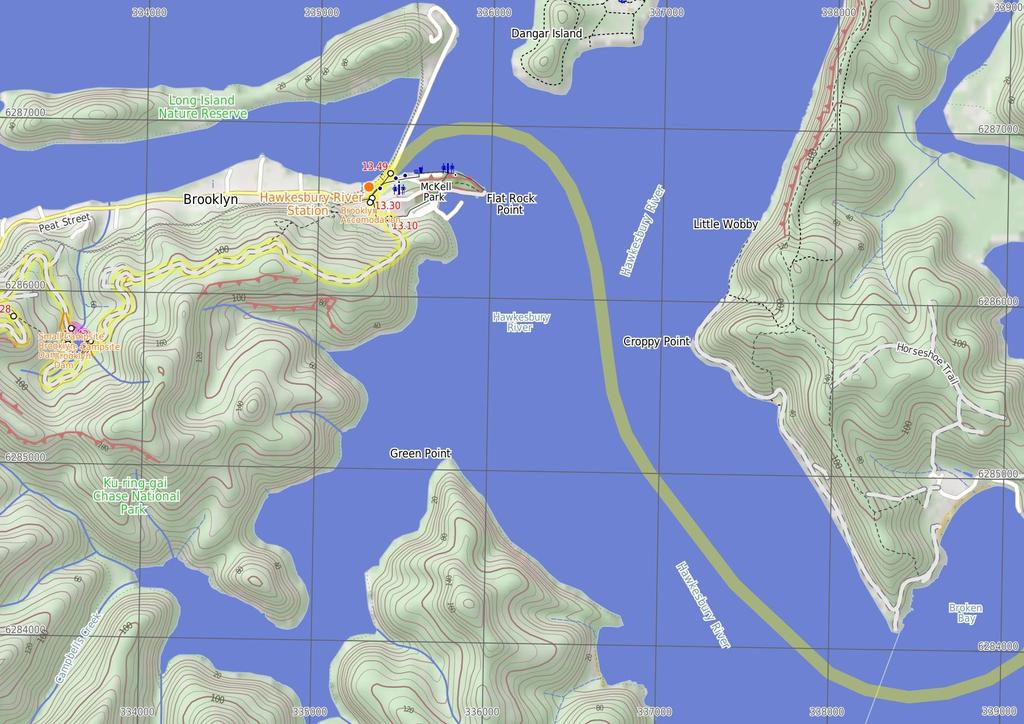
2 Jerusalem Bay Before You walk Jerusalem Bay, Ku-ring-gai National Park, is a nice bay east of Cowan Station. The bay is popular with bushwalkers as it is part of the Great North Walk. The bay is sometimes known for an iconic photo of the single palm in front of the water. The bay itself is also popular with boaters who can anchor in the bay. Jerusalem Bay can be accessed by the Hawkesbury River and Broken Bay or from Brooklyn or Cowan Railway Stations. Bushwalking is fun and a wonderful way to enjoy our natural places. Sometimes things go bad, with a bit of planning you can increase your chance of having an ejoyable and safer walk. Before setting off on your walk check Small Campsite Brooklyn Dam The small campsite next to Brooklyn Dam, Ku-ring-gai Chase National Park, is a small grassy campsite which has room for approximately four sites. The close proximity to Brooklyn Dam means close water. The campsite also has a few tall shady trees and is a fuel-stove only site. Large Campsite Brooklyn Dam The large campsite next to Brooklyn Dam, Ku-ring-gai Chase National Park, is a spacious and well-maintained campsite which has room for plenty of tents. The close proximity to the dam means accessible water (treat before drinking). The campsite has many tall, shady trees and is a fuel stove only site. The concrete dam wall was built in 1884 to provide water for the steam trains passing about 5m to the north. The dam was enlarged six times before 1924, then in in 1989 the dam was added to the expanded Ku-ring-gai Chase National Park. 1) Weather Forecast (BOM Metropolitan District) 2) Fire Dangers (Greater Sydney Region) 3) Park Alerts (Brisbane Water National Park, Ku-ring-gai Chase National Park) 4) Research the walk to check your party has the skills, fitness and equipment required 5) Agree to stay as a group and not leave anyone to walk solo Think before you TREK The 'Think before you TREK' program developed by NSW Police & NPWS promotes the benefits of planning ahead for your bushwalking trip by using an easy to remember acronym: adequate supplies of food, water, navigation and first T Take aid equipment. your planned route and tell friends and family when R Register you expect to return. beacon (PLB's) should be carried on walks with E Emergency significant gaps in mobile coverage (check terrain profile). to your planned route and follow the map and walking K Keep trails. Brooklyn Accomodation Topo Maps Brooklyn is a lovely little village with plenty of holiday style accommodation. There are several small cafe/restaurants in the area, good choice for cooked meals. There are two options for overnight visits, both need to be booked in advance. Brooklyn Motel: Newly renovated accommodation on Bridge St,nearly opposite The Anglers Rest. This studio style accommodation starts from $12 per night with a spa, television and free wifi. Ph: or Breakfast can be organised for an extra fee. The Anglers Rest: Pub style accommodation on the intersection of Brooklyn & Dangar Rds. There are shared bathroom facilities. From $6 single and $9 a double. Breakfast not included (but you can grab breakfast from a cafe) PH:(2) The maps provided on wildwalks are helpful, but there are times where you may need maps covering a broader area. Maps that cover this walk include; 1:25 Map Series:91312S GOSFORD, 9134N COWAN, 9131N BROKEN BAY 1:4 Map Series:CMA Ku-ring-gai Chase National Park Tourist Map 1:1 Map Series:9131 GOSFORD, 913 SYDNEY Grade This walk has been graded using the AS The overall grade of the walk is dertermined by the highest classification along the whole track. 4 Grade 4/6 Hard track Length 33.4 km One way Time 2 Days Quality of track Rough track, where fallen trees and other obstacles are likely (4/6) Signs Minimal directional signs (4/6) Experience Required Some bushwalking experience recommended (3/6) Weather Storms may impact on navigation and safety (3/6) Infrastructure Limited facilities (such as cliffs not fenced, significant creeks not bridged) (4/6)
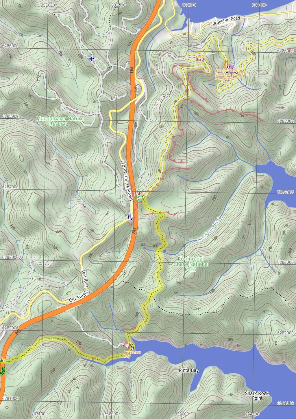
3 Are you ready to have fun? Please ensure you and your group are well prepared and equipped for all possible hazards and delays. Check park closures, weather information and Fire Danger Rating before setting out. Optional side trips and alternate routes noted are not included in this walks overall grade, length or time estimate. Please allow extra time for resting and exploring areas of interest. The authors, staff and owners of wildwalks take care in preparing this information but will not accept responsibility for any inconvenience, loss or injury you may experience. Please take care, have fun - Happy Walking. Getting there You can get to Cowan Station (gps: , ) by car, train or bus. Car: There is free parking available. Traveling by train is the only practical way to get back from Wondabyne Station (gps: , ). Find up to date and more information inlcuding; travel directions, weather, park closures and walker feedback at Cowan Station (3 m 6 mins) From the front of Cowan station, this walk follows the GNW arrow up the concrete ramp, turning right to cross the track at the controlled 'Pedestrian Railway Crossing'. The walk follows the ramp onto platform 1 (Sydney-bound side) then around the shelter to follow the GNW arrow post right, down the steps and through the gate. Here the walk crosses the train lines (train storage area) and turns left, following the 'Brooklyn' sign along the wide management trail. After 13m, the trail leads past an electrical switching area then turns right at the large 'Great North Walk' signposts. Here, the narrower trail leads between the fences over a small rise to cross the freeway on a large, fenced concrete bridge..3 Freeway Bridge (2.2 km 5 mins) Continue straight: From the overpass, this walk heads away from the freeway and down the wide track. The track leads down a series of timber steps, then over a small rise (among the scribbly gums) where the track begins to narrow and lead more steeply down a rocky section. The walk then heads down a series of timber steps (passing a 'Great North Walk' sign), and crosses a short section of timber boardwalk. At the other end of the boardwalk, this track leads left over a rock platform (with a small creek flowing after rain) and then turns right to step off the rock platform. Continue straight: From the intersection, this walk heads downhill along the rocky track. The track leads past a few rock walls over about 35m, then turns right onto, then steps down off, a long thin rock platform. The track continues down along the side of the valley for another 2m, passing into a much more lush and dense forest, where the track then crosses the creek at a large rock platform. On the other side of the creek, the track leads right down along the other side of the valley, passing a few small sandstone overhangs then a particularly broad angophora tree after about 5m. Soon after this angophora, the track leads down some rock steps then begins to widen for about 3m, and passes a small track (on your right) marked with a 'No Camping or fires allowed' sign. By this point, the broad waters (or mud flats, depending on the tide) of Cowan Creek are obvious, on your right. The walk now continues along the generally broad and flat track for another 5m, then climbs up a set of concrete steps, marked with a GNW arrow post. At the top of these steps is a large, fairly flat clearing with a 'No Camping' and a 'Great North Walk' sign and a great view up the middle of Jerusalem Bay Jerusalem Bay Jerusalem Bay, Ku-ring-gai National Park, is a nice bay east of Cowan Station. The bay is popular with bushwalkers as it is part of the Great North Walk. The bay is sometimes known for an iconic photo of the single palm in front of the water. The bay itself is also popular with boaters who can anchor in the bay. Jerusalem Bay can be accessed by the Hawkesbury River and Broken Bay or from Brooklyn or Cowan Railway Stations Jerusalem Bay (3 km 1 hr 29 mins) Continue straight: From the clearing at Jerusalem Bay, this walk follows the 'Great North Walk' sign, keeping the water to your right. The track bends left then leads down some sandstone steps (with a handrail). The track soon becomes fairly rough and follows the shoreline for about 2m before crossing a rocky and mossy gully. On the other side of this gully, the track tends right, following the GNW arrow post past a sandstone overhang, and over a small flat timber bridge. Just past this bridge, the track bends left and starts to climb steeply up the particularly rocky track. After about 3m of climbing, the track passes a small clearing with a small seat (on your right). Over the next 4m, the rocky track still heads up, but is generally less steep. The walk then comes to a large rock outcrop, where the track turns right to head up through a rocky gully. About 6m after this climb, the track leads up another short climb to a rock platform, then a third consecutive climb leads up through a crack in a rock to find a much welcomed bench seat and 'Great North Walk - Track Register' log book box. From here, the walk follows the the track gently uphill for another 6m to a 'Jerusalem Bay' sign pointing back along the track, at the top of the ridge. Continue straight: From the top of the ridge, this walk follows the 'Brooklyn Dam' sign, gently uphill, heading north through the tall heath. The mostly flat track leads through the forest, with an occasional glimpse to the freeway and down to Brooklyn. after about 4m, the track bends left and leads through a long cleft in the rock. Here the track start to head more and more steeply down for the next 35m, until heading down some timber steps which lead to Campbells Creek. The walk steps over the small (orange, polluted ) creek to find a flat sandy clearing a few metres past the creek. Continue straight: From the small clearing, this walk follows the clear track away from the creek, and soon bends left then begins to climb. The rocky track climbs steeply for about 2m, passing among the grass trees and eucalyptus. The track flattens out and passes alongside a rock wall, then resumes the climb up the hill. At the top of this climb, the track passes a couple of small rock overhangs then climbs about halfway up a section of rock to follow the longer section of rock platform to the right. The track then gently undulates along the side of the hill, passing a section of hand rail after about 7m. The track then follows a series of small rock walls (on your left) for about 25m before climbing up onto a flat, sandy track. This soon leads to a faint intersection (with a track on your right, which goes to a large rock platform). From here, the sandy track stays mostly flat for about 3m before veering left at a GNW arrow post, leading up a more rocky section of track and then climbing up some steel pegs in the rock wall at the next GNW arrow post. Here the track leads up the short hill and comes to a T-intersection with a wide management trail, where a 'Jerusalem Bay' sign points back down the hill. continues along the main trail for another 9m then follows a GNW arrow post as the trail bends left, then right, to head downhill notably steeply for a short time. The trail then continues to undulate along the top of the ridge for about 1.2km, passing more side tracks to power poles (some with unfenced views). The walk then comes to a point where the trail bends sharply right, and there is a filtered view over the Hawkesbury River to Peats Ferry Bridge. From here, the walk heads quiet steeply down for about 4m to pass under some power lines, where the trail then bends sharply left (enjoying some filtered views down to Brooklyn Dam and the Hawkesbury, on your right), passing under then same power lines again. The trail soon flattens out, coming to a faint three-way intersection (with a re-vegetating track on your right), marked with a 'Great North Walk' sign Optional sidetrip to freeway view point (1 m 2 mins) Turn left : From the intersection, this walk heads in the opposite direction to the 'Brooklyn' arrow, uphill along the wide management trail, keeping the power lines to your left. The trail leads through the tall heath and soon heads more steeply up a short hill to a concrete section of old road. The concrete section leads to the unfenced view point at the top of a large cutting, overlooking the freeway. At the end of this side trip, retrace your steps back to the main walk then Continue straight NW Brooklyn Dam Campsite intersection (9 m 2 mins) Continue straight: From the intersection, this walk follows the GNW arrows post south along the wide trail, soon passing alongside the dam (on your left). About 4m after passing edge of the dam wall, this walk comes to an intersection with a re-vegetating track (on your right) and a large 'Ku-ring-gai Chase National Park - Brooklyn Dam' sign (on your left) Int. Jerusalem Bay Trk and Brooklyn Dam Service Tr (2.8 km 57 mins) Turn right: From the intersection, this walk follows the 'Brooklyn' sign down along the wide management trail, initially keeping the power lines to your right. The trail gently undulates along the top of the ridge for about 7m, passing a few short side tracks (which lead to the power poles) and distant valley glimpses. The trail leads over a solid rock platform and less than 1m later, the walk leads past a track (on your right, which leads to a unfenced view over the valleys, from the power pole). The walk 8.28 Upper Int. of Brooklyn Dam Service Track and Brook (1.3 km 28 mins) Continue straight: From the intersection, this walk follows the 'Great North Walk' sign along the wide management trail as it initially leads over a small rise then heads downhill, keeping the valley to your right. After about 3m, the trail turns sharp right at the T-intersection with another wide trail. This flat wide trail follows the power lines for about 25m to then veer left (at the Y-intersection), heading downhill away from the power lines. The trail leads downhill for just shy of 3m, passing the speed hump signs to then bend right at the large clearing (ignoring the fenced trail on your left). Then about 1m later, this walk ignores another fenced trail (on your left) as this trail is still bending right. Here the trail heads around the side of the hill for 4m to come to an intersection with a track (on your left, leading a few meters to the signposted campsite) marked with a GNW arrow post Small Campsite Brooklyn Dam The small campsite next to Brooklyn Dam, Ku-ring-gai Chase National Park, is a small grassy campsite which has room for approximately four sites. The close proximity to Brooklyn Dam means close water. The campsite also has a few tall shady trees and is a fuel-stove only site Alternate Route NW Brooklyn Dam Campsite to NE Bro (18 m 4 mins) Turn left: From this intersection, this walk follows the track east, away from the main trail and through the small 'Brooklyn Dam' campsite. On the other side of the campsite, the narrow track bends right and leads down into the gully, down a few concrete steps then heading alongside the small creek. Just before the dam wall, the track bends left, across the creek and up the short rocky hill to find a larger clearing. There is a good view over the dam (on your right). The track continues bending right through the clearing, and up a short hill to an intersection with the wide trail. Now Turn left to rejoin the main walk Lower Int. of Brooklyn Dam Service Track and Brook (7 m 13 mins) Continue straight: From the intersection, this walk follows the GNW arrow post along the wide trail, keeping the dam to your left. (This section of trail leads around to the far side of the dam.) After just over 25m, the trail crosses a small creek (at the apex of the dam) then continues bending left. The track passes some old concrete pipes (on your left) then after about 4m, the trail comes to an intersection with a clearing and dam wall (to your left) Large Campsite Brooklyn Dam
4 The large campsite next to Brooklyn Dam, Ku-ring-gai Chase National Park, is a spacious and well-maintained campsite which has room for plenty of tents. The close proximity to the dam means accessible water (treat before drinking). The campsite has many tall, shady trees and is a fuel stove only site. The concrete dam wall was built in 1884 to provide water for the steam trains passing about 5m to the north. The dam was enlarged six times before 1924, then in in 1989 the dam was added to the expanded Ku-ring-gai Chase National Park NE Brooklyn Dam Campsite (2.7 km 59 mins) Veer right: From the intersection, this walk follows the GNW arrow post uphill along the management trail, directly away from the dam. After about 3m, the trail bends right and passes a 'Ku-ring-gai Chase National Park - Brooklyn Dam' sign and continues uphill for another 15m, to where the trail becomes less steep (enjoying some filter views over the Hawkesbury on your left) for about 18m. Here a GNW arrow post guides along a short track (on the left), that runs parallel before re-joining the main trail again a short distance later. The walk then continues uphill to veer right at a three-way intersection, under the power lines, then about 12m later, this walk veers right again at another three-way intersection. About 7m up from here, the walk veers left at another three-way intersection, this time the trail generally follows the power lines along the side of the ridge. After another 3m, the trail bends right and passes under a set of high tension power lines, then continues to gently undulate for another 6m to come to a three-way intersection (with a clearing and trail on your left) and a 'Cowan' sign pointing back along the trail. Continue straight: From the intersection, this walk follows the 'Brooklyn Station' sign gently downhill along the management trail, keeping the Hawkesbury River glimpses to your left. The trail gently undulates for about 6m before bending left to find a large clearing and water glimpses. From the clearing, the trail starts to lead downhill towards the water, and after nearly 1m, the trail leads steeply down a short section of concreted trail. Just after this, the trail leads steeply again over a longer section of concrete, where the trail then leads through a rock cutting to find an even longer and steeper section of concrete trail. This section of concrete leads down for about 22m, sweeping left to head around a locked gate, past a large 'Great North Walk' sign to find the southern end of William St. Here the walk turns right to head down William St then across George St to find a few 'Great North Walk' signs on the corner Int of George & William Sts (2 m 4 mins) Turn left: From the intersection, this walk follows the 'Great North Walk - Direct Route' sign gently uphill along the footpath beside George St. At the top of this hill, the walk turns right onto 'Bridge St' and heads down past a cafe, post office and 'The Anglers Rest' (on the other side of the road) and crosses 'Brooklyn Rd' to find a phone box on the other side Brooklyn Accomodation Brooklyn is a lovely little village with plenty of holiday style accommodation. There are several small cafe/restaurants in the area, good choice for cooked meals. There are two options for overnight visits, both need to be booked in advance. Brooklyn Motel: Newly renovated accommodation on Bridge St,nearly opposite The Anglers Rest. This studio style accommodation starts from $12 per night with a spa, television and free wifi. Ph: or Breakfast can be organised for an extra fee. The Anglers Rest: Pub style accommodation on the intersection of Brooklyn & Dangar Rds. There are shared bathroom facilities. From $6 single and $9 a double. Breakfast not included (but you can grab breakfast from a cafe) PH:(2) Int of Brooklyn AND Dangar Rds (9 m 1 mins) Continue straight: From the intersection, this walk follows the footpath down along Dangar Road past the phone box, keeping the train line and road to your left. The path soon leads past the community centre then the blue painted 'JJs Brooklyn' fish and chip store to come to the sandstone 'Obelisk' commemorating the naming of the Hawkesbury River. This is just on the other side of the road, opposite some large 'Great North Walk' signs and the Hawkesbury River Railway Station Broken Bay View Broken Bay View is an informal, unnamed and unfenced vantage point at the top of the cliffs, east of Patonga. The large rock platform has a number of large Sydney Red Gums, providing some shade. There are great views across the Hawkesbury River, along Cowan Creek and to West Head. The views to the left extend past Lion Island to Barrenjoey Head and out to the Pacific Ocean Brooklyn Railway Station (1 m 2 mins) Continue straight: From the street-side of Brooklyn Railway Station, this walk heads north-east along the footpath, towards the water, for approximately 5m, coming to the ferry terminal on the other side of the car park Broken Bay View (7 m 15 mins) Veer left: From the Broken Bay view, this walk follows Great North Walk arrows uphill along the track. The track winds gently through the bush, with the occasional water glimpse to the right. After a short time, the track comes to a clear intersection with the Pearl Beach / Patonga fire trail with a sign pointing back to 'Patonga'. Veer right: From the intersection, this walk follows the Great North Walk arrow downhill along the wide management trail. After about 25m, the trail passes a track on the right (marked with 5 large boulders - this informal track leads to an unfenced view). The walk continues along the management trail for another 1m and comes to an intersection near the Warrah Lookout, and a sign pointing back to 'Patonga' Brooklyn Ferry Terminal (8.4 km 1 Hr) Continue straight: From the wharf near Hawkesbury River (Brooklyn) Station, the walk becomes a ferry ride. This service needs to be booked ahead of time (only runs when there are enough people). The ferry usually runs once a day (except Fridays) at 1:3 pm from Brooklyn, arriving at Patonga Beach at 2:2pm. On weekends, there is an extra service at 11: am from Brooklyn, arriving at Patonga Beach at 11:45am. Times are affected by weather. Phone: (2) Alternatively, you can catch a water taxi - they generally cost about $1 per group of 4 and need to be booked ahead. There are a few options - try Hawkesbury River Water Taxi on or Rick on More info Patonga Village Patonga Village is a lovely small township on the Hawkesbury River. Just near the ferry wharf are a few helpful facilities: The Eve Williams Memorial Oval, where you will find a large pavilion, drinking water and public toilets. A fish and chips shop (and general store) is open reasonable hours, where you can buy lunch, a coffee and basic supplies (fishing needs, milk, canned food). Patonga Beach Hotel is available for a cold drink at the bar or a meal on the deck, or even overnight accommodation (from $242 a couple) ph: Patonga Wharf car park (53 m 1 mins) Veer right: From the car park at Patonga wharf, this walk follows the footpath beside Patonga Drive, keeping the water on the right. The road leads out of town passing beside 'Eve Williams Memorial Oval' for 7m to find a large 'The Great North Walk' sign opposite the toilet block. Soon after this sign, this walk turns right following the 'Boat Ramp' sign and GNW arrow post down along a side road for 22m to find a parking area beside Patonga's boat ramp. (Alternatively it is possible to walk along the sandy beach from the wharf to the boat ramp.) Continue straight: From the boat ramp, this walk follows the power lines across the car park, keeping the water to the right. The walk heads around the gate and continues to follow the power lines across the sand, coming to the eastern end of Patonga Beach and the 'Brisbane Water National Park' sign. This area of the beach is also know as 'Dark Corner' Eastern end of Patonga Beach (59 m 21 mins) Continue straight: From the eastern end of Patonga beach, this walk follows the 'Warrah Trig 1.7km' sign up the steps. The track winds up the side on the hill, turning left and following the ridge line uphill. Soon after passing up some stairs between the rock, the track comes to a lovely view across the water. Here, the track turns left and climbs up more steps before flattening out and passing a few more GNW arrows. Just after passing two GNW arrows next to each other (at the end of a large crack in the rock), the track passes a few large Sydney Red Gums and comes to an unfenced rock platform on the right - Broken Bay view Optional sidetrip to Warrah Lookout (7 m 2 mins) Turn right: From the intersection, this walk heads between the timber posts and follows the 'Warrah Lookout' sign along the sandstone footpath. The path leads through the bush for a short distance, coming to the fenced Warrah Lookout. (Beware of informal side tracks that lead to unfenced sections of cliff.) At the end of this side trip, retrace your steps back to the main walk then Continue straight Warrah Lookout Warrah Lookout is a mostly fenced lookout on a large sandstone platform. The lookout provides fantastic views across the Hawkesbury River. From left to right, you can see along the escarpment which forms the southern boundary of Brisbane Water National Park, out to the Pacific Ocean, Barrenjoey Headland, West Head, along Cowan Creek, Juno Point and along the escarpment to Patonga. This is a great place to spend some time soaking up the views Warrah Lookout intersection (31 m 7 mins) Turn left : From the intersection, this walk follows the 'Tony Doyle Track, Warrah Car Park' sign up the sandstone steps and footpath. After winding through and over some rock platforms, the path leads up the hill to two sets of timber staircases. At the top of the second set, the walk comes to the old Warrah Trig station (a green metal post) Warrah Trig Station Warrah Trig Station is part of a national geodetic survey established during the 197's. The 'Triangulation station' (aka trigonometrical or trig station) is a distinct marker once clear of trees, and would have been visible for many kilometers in the area. There are many such trig stations around Australia, which were used to help in surveying. Each station has a know position and altitude, which allows surveyors to use triangulation and determine another point's location. With advances in technology, these trig stations have been abandoned and superseded. The trig station is now surrounded by trees, with some filtered views along the Hawkesbury River. The area is rich with wildflowers in spring Warrah Trig Station (3 m 1 mins) Continue straight: From Warrah Trig Station, this walk follows the sandstone steps and footpath down the hill towards the dirt road. The path soon passes a plaque and a sign pointing back along the 'Tony Doyle Track'
5 and comes to the Warrah car park. 24 Warrah Car Park (31 m 5 mins) Continue straight: From Warrah car park, this walk follows the road off the sealed section and along the dirt. The road passes a larger dirt overflow car park, then ignores an old trail (on the right) to soon come to an intersection with a management trail and gate on the left side Int of Warrah Trig trail and Warrah Trig Station R (1.2 km 22 mins) Continue straight: From the intersection, this walk follows the dirt road north up a long and gentle hill. The road leads to an intersection with a track on the right marked with a Great North Walk arrow about 3m before Patonga Drive. Veer right: From the intersection, this walk follows the GNW arrow marker around the drainage ditch to follow the track running parallel to Patonga Drive (keeping the road about 2m to your left). The track leads through the heath and scribbly gum forest for about 1m before passing some distant ocean views (on your right), where the track continues for another 15m to come to the sealed Patonga Drive. Here the walk follows the GNW arrow post across the road to a locked gate and management trail, marked with a 'Great North Walk' sign Int of GNW and Patonga Dr (12 m 2 mins) Continue straight: From the intersection, this walk follows the 'Great North Walk' sign around the locked gate to follow the management trail away from the road. After about 1m, this walk comes to a clear threeway intersection marked with sign pointing back to 'Patonga' Int of Rest Area and Girrakool tracks (21 m 3 mins) Veer left: From the intersection, this walk follows the 'rest area' sign gently downhill along the management trail. After about 2m, this trail leads to a small camping area at an intersection (and a turning circle on your right) Patonga rest area This small campsite is a signposted rest area, and is about 2m off the Great North Walk, just north of Patonga Drive. The campsite is a small, sandy clearing, with no facilities and no water, but it is sheltered by trees End of day 1 This is the planned overnight stay for the end of day 1, happy camping.
6 25.85 Rest Area (95 m 15 mins) Turn around: From the rest area, this walk heads east along the management trail for about 2m to come to a clear three-way intersection, where a 'Rest Area' sign points back down along the trail. Turn left: From the intersection, this walk follows the 'Girrakool' sign gently up along the wide trail. After about 2m, the trail bends left, then leads gently down for another 1m, coming to an intersection where the main trail bends right (and with the narrower Patonga Creek trail ahead), marked with a GNW arrow post. Turn right: From the intersection, this walk follows the GNW arrow post north along the wide sandy management trail. The trail leads among the heath and large scribbly gums for about 27m to come to T-intersection with another wide trail, marked with a 'Patonga' sign pointing back up along the trail. Turn left: From the intersection, this walk follows the 'Girrakool' sign downhill along the management trail. Over the next 2m, the trail gently bends right then comes to an intersection (just before a large open rock platform), marked with a 'Girrakool' sign (pointing right) Int of Hawkesbury track and Patonga Dr trail (1.1 km 21 mins) Turn right: From the intersection, this walk follows the 'Girrakool' sign east uphill along the management trail. The trail leads up the hill for about 25m to head over a short rock platform where the trail continues fairly steeply uphill. The trail bends left and then winds gently around the side of the hill, enjoying some views along the way. The trail undulates for a while before leading gently down to pass a large clearing (on your left). Just past this clearing, the trail heads down (fairly steeply at first) for about 2m to enter a tall wooded forest and come to a clear three-way intersection, marked with a 'Sani Depot Trail' sign (on your right) Int of Hawkesbury track and Sani Depot Trail (1.3 km 25 mins) Continue straight: From the intersection, this walk follows the GNW arrow post downhill along the wide trail. The trail soon leaves the tall Sydney Redgums to lead down for almost 6m. The walk crosses a culverted creek (with sandstone blocks) and then the trail mostly flattens out. Here the trail continues for another 17m leaving the tall forest to walk through the open heath, passing near a small cliff (on your right), to come to an intersection with the faint track (on your left, this is just before the main trail bends right and starts to lead downhill again). Continue straight: From the intersection, this walk follows the wide trail downhill, keeping the valley to your left. The trail winds downhill for almost 6m, crossing a couple of culverted creeks, until, just after a left-hand bend, this walk comes to a noteable rock platform (with an ephemeral creek) and filtered view down the valley (to your left) Rock Platform (52 m 12 mins) Continue straight: From the rock platform, this walk follows the trail north up the side of the hill. The trail leads uphill for about 25m before bending left and leading downhill for about 8m, where the trail winds through a ferny valley with a scattering of cabbage palms (Livistona australis). Here the trail leads quite steeply uphill for about 2m, then more gently downhill for just over 2m more, to come to a Y-intersection with the signposted 'Great North Walk' track (on your left). (The trail ahead soon leads over Patonga Creek to the locked back gate of Woy Woy Landfill) Int of Hawkesbury track near Patonga Creek (2.3 km 52 mins) Turn left: From the intersection, the walk follows the 'Great North Walk' sign downhill along the track. After just shy of 1m, the track crosses Patonga Creek among the moist cabbage palm forest. Soon after crossing this creek, the track begins to head quite steeply uphill for another 1m, passing a faint side track before climbing up some carved steps in the rock beside a sloped rock platform (on your left). The track continues steeply up for another 4m, where the track bends right (at the GNW arrow post) to head over a mostly flat rock outcrop. The track continues (with occasional glimpses of the Woy Woy landfill) gently uphill for just over 1m to pass another side track, then lead up a bit more steeply for just over 1m more (past a rock wall, on your left) to come to an unfenced clear view over Woy Woy landfill (where the track bends left). Veer left: From the view point over Woy Woy Landfill, this walk heads west following the rocky track uphill, directly away from the view. The sandy track soon leads up a few rock steps and after about 13m, climbs up a few carved steps onto a fairly large rock platform, marked with a GNW arrow post. The track now undulates, following a series of GNW arrow posts (generally up) along a rocky ridge line, passing over many rock platforms for almost 1km (enjoying the distant views over Woy Woy Bay and the Brisbane Water, to your right) to come to the highpoint on this section of track. From here, the track continues mostly flat for the next 5m, then begins to head downhill for about 3m to come to a clear intersection with the signposted 'Dillons Trail'. There is a sign pointing back up the track towards 'Patonga' Int of Hawkesbury Track and Dillons Trail (65 m 12 mins) Continue straight: From the intersection, this walk follows the GNW arrow post west (in the opposite direction to the 'Patonga' sign. After about 2m, this short track leads to an intersection with the signposted 'Tunnel Trail'. Turn right: From the intersection, this walk follows the GNW arrow post gently uphill along the 'Tunnel Trail'. After about 5m, the trail passes through a metal gate and fence then continues for just over 1m to come to the signposted intersection with the 'Rocky Ponds Trail', where a 'Patonga' sign points back down along the trail. Continue straight: From the intersection, this walk follows the GNW arrow marker and the 'Girrakool' sign north, gently uphill along the wide trail. The trail winds along the side of the hill for just over 45m, to come to a small crest and a clear three-way intersection with the signposted 'Mt Wondabyne' trail (on the left) Int of Tunnel Track and Mt Wondabyne trail (76 m 16 mins) Turn left: From the intersection, this walk follows the GNW arrow marker as well as the 'Mt Wondabyne' and 'Girrakool' signs uphill along the management trail. The trail winds up the hill for about 3m find a view of Mount Wondabyne - there are also nice views behind (and to the right) across Woy Woy and the Brisbane Water. The trail continues uphill for another 4m to end at a large clearing (turning circle) at the base of a rock wall. This is the Mt Wondabyne Campsite - there is also a sign pointing back down to 'Patonga' Mt Wondabyne Campsite This basic campsite is found at the end of a management trail, near the base of Mt Wondabyne. The campsite is at the bottom of a small (east facing) rock wall and has trees surrounding much of the area, providing some shelter. There is an established fire circle and a basic seat. There is no water or other facilities. (There is also small cave suitable for sleeping a few people about half way up Mount Wondabyne) Mt Wondabyne Campsite (9 m 2 mins) Turn right: From the clearing (campsite), this walk follows the 'Mooney Mooney rest area' sign north gently uphill along the rocky track. After about 9m, this track comes to a three-way intersection (with the Mt Wondabyne peak track, on the right), marked with a GNW arrow post Optional sidetrip to Mt Wondabyne Peak (21 m 5 mins) Turn right: From the intersection, this walk follows the Mt Wondabyne peak track north-east as it heads uphill directly towards Mt Wondabyne. The track is leads gently at first then starts to climb up a series of rock ledges. After about 6m, the track passes a small cave (large enough for 2 or 3 people to lie in). The track then continues to climb for another 9m, up the rocky track then for through a grove of small trees, to come to the first peak. The faint track continues along the ridge for another 6m then comes to the main peak, where there is an old trig station and great panoramic views. At the end of this side trip, retrace your steps back to the main walk then Turn right Mt Wondabyne Mount Wondabyne is one of the most prominent peaks in Brisbane Water National Park. The long cone-shaped hill has a rocky top and is home to a trig station. Walkers can enjoy full 36-degree panoramic views from the top. To the east are good views over the Brisbane Water, Woy Woy and other central coast suburbs. West, down next to Mullet Creek, you can see some buildings near Wondabyne Station and the train line. Otherwise, most of the expansive views are over much of Brisbane Water National Park. There are some small trees providing limited shade, a great place to soak up the views Int of GNW and Mt Wondabyne Peak tracks (95 m 21 mins) Continue straight: From the intersection, this walk follows the GNW arrow post north, gently down along the rocky track, keeping the Mt Wondabyne Peak up to your right. After about 5m, the track enters a forest of trees and begins to head more distinctly downhill, passing a few large boulders for about 7m, then coming to a GNW 'Walker Register' tube on a post. After writing a comment, the walk continues down the track over a rock platform, and just past the rock platform the sandy track leads downhill for about 2m as it widens significantly and comes to a T-intersection with another wide trail. There is a 'Mt Wondabyne' sign here, pointing back up the hill Int of GNW and Mullet Creek Trail (22 m 4 mins) Turn right: From the intersection, this walk follows the GNW arrow post and 'Wondabyne Station' sign down a gentle hill as the trail bends right. The trail leads downhill and bends again to run parallel with the some power lines. Then about 35 meters past the second power pole, this walk comes to an intersection with a track (on your left), marked with a GNW arrow post Int of GNW and Mullet Creek Trail (east) (83 m 18 mins) Turn left: From the intersection, this walk follows the 'Girrakool' sign, heading under the power lines and down along the track to soon cross a small ephemeral creek. From the creek, this walk follows a rock platform for about 2m to then head over a section of timber boardwalk and past a few disused power poles. The track soon begins to climb and crosses a number or rock platforms for about 3m to come to a notably large rock platform with a wide view across the valley to Mt Wondabyne. Here the track continues up for another 25m to an intersection with a wide trail (at another rock platform), where a 'Patonga' sign points back down along the track Int of GNW and Thommos Loop track (1.5 km 28 mins) Veer left: From the intersection, this walk follows the 'Girrakool' sign across the rock platform, keeping the valley to your left. The walk enjoys views of Mt Wondabyne (on the left) for about 13m to come to a particularly large rock platform. Here the trail leads down off this rock platform then winds along the side of the hill for about 1.3km (passing a pleasant grove of large Sydney Redgums) to lead up to an intersection (with a track on the left) where there is a sign pointing back to 'Patonga'.
.")
7 37.2 Int of the GNW and Patonga service trail (69 m 24 mins) Veer left: From the intersection, this walk follows the 'Girrakool' sign gently down along the narrower track. The track leads down for about 6m to pass over a rock outcrop and then 8m later, comes to a clearing that has been used as a campsite (on your left). From the clearing, the track continues down the hill for about 15m, stepping down the rocks and along a sandy track to then bend right at metal handrail. Here the rocky track becomes quite steep in places and winds down past some rock walls and among the grass trees for about 3m, where the track bends sharp right at the bottom of some steps in a cleft in the rock. The track continues down for another 1m to follow the steps down through the sandstone overhang, here the track bends left then right to wind down and cross the creek (that is often underground) and come to an intersection with a faint track in front of Kariong Brook Falls (on your right) Kariong Brook Falls This tranquil spot of the Great North Walk is home to some lovely falls and a water hole. The eastern side of the creek has a tall sandstone cave and wall. After rain these falls can become very spectacular, other times is a cool place to rest. A great spot to stop for a snack Kariong Brook crossing (4 m 11 mins) Continue straight: From the Kariong Brook, this walk follows the track north-west away from the cliffs (initially keeping the waterfall to your right). The track initially leads fairly steeply out of the densely forested valley then leads more gently uphill for about 1m to pass alongside a long rock wall (on your right). From the end of the rock wall, the track starts to lead downhill for about 2m, to then head down the embankment and steps and cross Myron Brook on the sandstone rock platform, to the western bank Myron Brook crossing (1.6 km 36 mins) Continue straight: From Myron Brook, this walk follows the rocky track west up the steep hilll. After about 4m of steep climbing, the track mostly flattens out to head up through the cleft in a rock and onto a flat rock platform. Here the track continues more gently uphill, crossing more rock platforms for just over 1km, through the heath and scribbly gums, before bending left around a rocky outcrop to come to a T-intersection with a wide management trail. There is large sign here, pointing back down to 'Patonga' Int of GNW and Wondabyne Station tracks (63 m 11 mins) Turn left: From the intersection, this walk follows the 'Wondabyne Station' sign downhill along the management trail. The trail gently undulates along the top of the ridge for about 6m to come to an intersection with the Pindar Cave track (leading over a rock platform, on your right), marked with a GNW arrow post (on your left). 4.3 Eastern end of the Pindar Cave Track (1 km 19 mins) Continue straight: From the intersection, this walk follows the GNW arrow post south, gently down along the wide management trail. The trail soon bends right and leads quite steeply down before mostly flattening out again. From here, the trail leads gently downhill for about 6m until the trail bends left and leads quite steeply down for just shy of 25m to come to a clearing at the end of this management trail, marked with a 'Brisbane Water National Park' sign Clearing above Wondabyne Station (44 m 13 mins) Continue straight: From the clearing, this walk follows the GNW arrow post south, down along the track to head down some carved steps through a cleft in a rock. The track winds steeply down the series of rock steps for about 15m to pass a filtered view (left) of the cranes, down at the old Gosford Quarry. The track continues to wind down, a little less steeply, for just over 2m to then climb down a timber staircase (which starts with a metal landing at the top). From the bottom, the walk continues down towards the train line, soon bending left to pass a large boulder and strangler fig tree and come to the north-bound platform of Wondabyne Train Station Wondabyne Wondabyne is situated in Brisbane Waters National Park on the banks of Mullet River, which feeds into the Hawkesbury River north of Brooklyn. The area is defined by the National Park's flora and fauna, the quarry, railway station and a few houses sitting above the water around the river. The quarry produced sandstone building materials, used in the construction of the National War Memorial in Canberra. More recently, in 2, the quarry was re-opened for restoration of St Mary's Cathedral spire in Sydney. Wondabyne Station, named after the nearby Mt Wondabyne, was built in 1889 and exclusively used for the quarry - it was then known as Mullet Creek Station. The station is one of the smallest on the line and one of very few railway stations in a NSW National Park. When you catch the train to Wondabyne, let the guard know you want to get off at Wondabyne Station, otherwise the train will not stop. Travel in the last carriage as the platform is very short. To catch the train from Wondabyne, wave to the driver.
8
9
10
11
12
13
14 Summary navigation sheet for the Cowan to Wondabyne station via Patonga rest area km From. Cowan Station , (GR Cowan, 33814) Freeway Bridge , (GR Cowan, 35816) Jerusalem Bay , (GR Cowan, ) Int. Jerusalem Bay Trk and Brooklyn Dam Service Trail , (GR Cowan, ) m 6 mins 2.2 km 5 mins 3 km 1 hr 29 mins 1 m 2 mins From the front of Cowan station, this walk follows the GNW arrow up the concrete ramp, turning right to cross the track at the controlled 'Pedestrian Railway Crossing'. Continue straight: From the overpass, this walk heads away from the freeway and down the wide track Int. Jerusalem Bay Trk and Brooklyn Dam Service Trail , (GR Cowan, ) km 57 mins Turn right: From the intersection, this walk follows the 'Brooklyn' sign down along the wide management trail, initially keeping the power lines to your right Upper Int. of Brooklyn Dam Service Track and Brooklyn Dam Bushtrack , (GR Cowan, ) km 28 mins Continue straight: From the intersection, this walk follows the 'Great North Walk' sign along the wide management trail as it initially leads over a small rise then heads downhill, keeping the valley to your right NW Brooklyn Dam Campsite , (GR Cowan, ) NW Brooklyn Dam Campsite intersection , (GR Cowan, ) Lower Int. of Brooklyn Dam Service Track and Brooklyn Dam Bushtrack , (GR Cowan, ) m 4 mins 9 m 2 mins 7 m 13 mins Alternate Route NW Brooklyn Dam Campsite. Turn left: From this intersection, this walk follows the track east, away from the main trail and through the small 'Brooklyn Dam' campsite. Continue straight: From the intersection, this walk follows the GNW arrows post south along the wide trail, soon passing alongside the dam (on your left). Continue straight: From the intersection, this walk follows the GNW arrow post along the wide trail, keeping the dam to your left km 59 mins 2 m 4 mins 9 m 1 mins 1 m 2 mins 8.4 km 1 Hr 53 m 1 mins 59 m 21 mins 7 m 15 mins Veer right: From the intersection, this walk follows the GNW arrow post uphill along the management trail, directly away from the dam. Turn left: From the intersection, this walk follows the 'Great North Walk - Direct Route' sign gently uphill along the footpath beside George St. Continue straight: From the intersection, this walk follows the footpath down along Dangar Road past the phone box, keeping the train line and road to your left. Continue straight: From the street-side of Brooklyn Railway Station, this walk heads north-east along the footpath, towards the water, for approximately 5m, coming to the ferry terminal on the other side of the car... Continue straight: From the wharf near Hawkesbury River (Brooklyn) Station, the walk becomes a ferry ride NE Brooklyn Dam Campsite , (GR Cowan, ) 13.1 Int of George & William Sts , (GR Cowan, ) 13.3 Int of Brooklyn AND Dangar Rds , (GR Cowan, ) Brooklyn Railway Station , (GR Cowan, ) Brooklyn Ferry Terminal , (GR Cowan, ) Patonga Wharf car park , (GR Broken Bay, ) Eastern end of Patonga Beach , (GR Broken Bay, 42863) Broken Bay View , (GR Broken Bay, 46862) Up/Dwn Length Initial directions (Use full tracknotes and maps for more detail) Continue straight: From the clearing at Jerusalem Bay, this walk follows the 'Great North Walk' sign, keeping the water to your right. Optional sidetrip to freeway view point. Turn left : From the intersection, this walk heads in the opposite direction to the 'Brooklyn' arrow, uphill along the wide management trail, keeping the power lines to your left. Veer right: From the car park at Patonga wharf, this walk follows the footpath beside Patonga Drive, keeping the water on the right. Continue straight: From the eastern end of Patonga beach, this walk follows the 'Warrah Trig 1.7km' sign up the steps. Veer left: From the Broken Bay view, this walk follows Great North Walk arrows uphill along the track.
Jerusalem Bay Track (Cowan to Brooklyn)
") Jerusalem Bay Track (Cowan to Brooklyn) 5 hrs 30 mins 13.4 km One way Hard track 4 654m This Cowan to Brooklyn Station walk is a popular section of the Great North Walk, with scenery ranging from foreshore
Jerusalem Bay Track (Cowan to Brooklyn) 5 hrs 30 mins 13.4 km One way Hard track 4 654m This Cowan to Brooklyn Station walk is a popular section of the Great North Walk, with scenery ranging from foreshore
Patonga to Staples Lookout
 Patonga to Staples Lookout 6 hrs 3 mins 17 km One way Hard track 4 72m This great walk explores much of the main ridge ridge running through Brisbane Water National Park. The walk visits a number of great
Patonga to Wondabyne station via Mt Wondabyne
 Patonga to Wondabyne station via Mt Wondabyne 7 hrs 3 mins 19.5 km One way Hard track 4 861m This walk explores some grand views, pleasant cascades, varied bushland and remote areas of Brisbane Waters
Staples Lookout to Mt Wondabyne loop
 Staples Lookout to Mt Wondabyne loop 4 hrs 3 mins 1.8 km Circuit Hard track 337m This walk starts and finishes at Staples Lookout, on Woy Woy Rd. The walk follows sections of the Great North Walk around
Patonga to Wondabyne station via Pindar Caves overnight
 Patonga to Wondabyne station via Pindar Caves overnight 2 Days Experienced only 28.1 km One way 5 1164m This overnight hike starts from Patonga beach and winds along a section of the Great North Walk,
Girrakool to Wondabyne station
 Girrakool to Wondabyne station 4 hrs Hard track 9.5 km One way 4 438m This walk starts from the Girrakool picnic area and winds south, through the Brisbane Waters National Park. The walk crosses some long
Mt Kuring-gai Track to Berowra station
 Mt Kuring-gai Track to Berowra station 4 hrs 15 mins 9.7 km One way Hard track 4 553m This walk explores three valleys, with great displays of wild flowers in spring, and some nice sandstone overhangs.
Berowra Waters to Cowan Station
 Berowra Waters to Cowan Station 3 hrs 30 mins 7.2 km One way Hard track 597m This is a hilly walk out of the beautiful Berowra Waters valley to Cowan Station. There are many wide views across Berowra Creek
Congewai Track Head (East) to Watagan Headquarters
 to Watagan Headquarters") Congewai Track Head (East) to Watagan Headquarters 7 hrs Hard track 17.2 km One way 4 973m This full day walk starts from the Congewai valley trackhead (east) and follows the Great North Walk up into the
Congewai Track Head (East) to Watagan Headquarters 7 hrs Hard track 17.2 km One way 4 973m This full day walk starts from the Congewai valley trackhead (east) and follows the Great North Walk up into the
Girrakool to Wondabyne station via Pindar caves
 Girrakool to Wondabyne station via Pindar caves 7 hrs 30 mins 18.1 km One way Experienced only 5 741m This walk starts from the Girrakool picnic area and winds south, following Piles creek into the Brisbane
Victoria Falls Lookout to Blue Gum Forest
 Victoria Falls Lookout to Blue Gum Forest 8 hrs Experienced only 13.8 km One way 5 112m This long day-walk follows a remote track down from Victoria Falls lookout, passing the waterfall, and into the Grose
Merritts Traverse. 1928m
 Merritts Traverse 3 hrs Hard track 5.8 km Circuit 4 167m This walk starts with a scenic journey to the top of the hill on the chairlift. Starting along Merritts Nature walk, this walk soon detours down
Erskine Creek via Pisgah Rock and Jack Evans
 Erskine Creek via Pisgah Rock and Jack Evans 4 hrs 30 mins 7.1 km Circuit Very experienced only 6 421m This walk visits some great lookouts and explores the lower section of Erskine Creek. Most of the
Berowra to Cowan via Berowra Waters
 Berowra to Cowan via Berowra Waters 6 hrs Hard track 12.9 km One way 4 884m With train station at each end this walk explores the ridges and valleys around Berowra Waters. There are plenty of excellent
Leura Cascades to Gordon Falls Reserve
 Leura Cascades to Gordon Falls Reserve 1 hr 15 mins 1.8 km One way Moderate track 200m From Leura Park to Gordon Falls Park, this diverse walk offers fantastic views of the Jamison Valley, as well as two
Nature Track. 900m. 789m. 2 hrs 3.1 km Circuit. Hard track 238m. Blue Mountains National Park
 Nature Track 2 hrs 3.1 km Circuit Hard track 238m Largely following the ridges around the top edge of Wentworth Falls, this track is incredibly beautiful. After taking in the great views at Edinburgh Castle
Wondabyne station to Somersby Store
 Wondabyne station to Somersby Store 10 hrs Hard track 26.2 km One way 4 1164m This walk, following a section of the Great North Walk, starts from the Wondabyne train station and winds north, into the Brisbane
Crosslands to Brooklyn
 Crosslands to Brooklyn 2 Days Hard track 27.4 km One way 4 1757m From the Crosslands Reserve, this walk heads along the Great North Walk via Berowra Waters, Cowan, Jerusalem Bay and onto Brooklyn. This
Guthega to Mt Twynam. 2183m. 1583m. 6 hrs 45 mins 14.8 km Return. Experienced only. 913m
 Guthega to Mt Twynam 6 hrs 45 mins 14.8 km Return Experienced only 5 913m This walk starts from Guthega and makes its way along the Snowy River to the Illawong Lodge, via the Blue Cow Creek flying fox.
Abbotts Falls Walking Track
 Abbotts Falls Walking Track 3 hrs 7.3 km Circuit Hard track 329m This circuit takes you through both dry and moist forest, using a combination of walking trails and wider tracks. The side trip to the dammed
Crosslands to Berowra Waters return
 Crosslands to Berowra Waters return 6 hrs Hard track 13.7 km Return 4 1005m This return walk starts from the Crosslands Reserve and follows the Great North Walk along Berowra creek. The walk includes some
Crosslands to Cowan. 220m
 Crosslands to Cowan 7 hrs 30 mins 14 km One way Hard track 4 1103m This section of the Great North Walk starts from the Crosslands camping area and winds north alongside Berowra creek, passing through
National Pass. 893m. 665m. 3 hrs 30 mins 4.6 km Circuit. Hard track 773m. Blue Mountains National Park
 National Pass 3 hrs 3 mins 4.6 km Circuit Hard track 773m 4 This walk offers fantastic views of the Jamison Valley and the surrounding cliffs. Take time to explore the historic and very scenic ledge halfway
Dadder Cave and Jack Evans track
 Dadder Cave and Jack Evans track 2 Days 10.3 km Circuit Very experienced only 535m This fairly short overnight walk is a great way to explore Erskine Creek. The walking along Erskine creek is mostly off
Gibberagong Track. 169m
 Gibberagong Track 2 hrs 30 mins 6.5 km One way Hard track 4 180m Starting in suburban Wahroonga, this wellmaintained track follows Cockle Creek down to Bobbin Head in the Ku-ring-gai Chase National Park.
Scenic Railway to Ruined Castle
 Scenic Railway to Ruined Castle 7 hrs 30 mins 12.4 km Return Hard track 4 963m This is a very popular, full day walk, in the Katoomba Area, offering great views of the valley. The walk follows the edge
Wentworth Pass. 893m. 535m. 4 hrs. Hard track 5.1 km Circuit. 692m
 Wentworth Pass 4 hrs Hard track 5.1 km Circuit 4 692m This walk offers a great way to explore the magical, upper section of the Valley of the Waters. The walk starts and finishes at Conservation Hut, which
Somersby to Yarramalong via Stringy Bark Point
 Somersby to Yarramalong via Stringy Bark Point 2 Days Hard track 26.7 km One way 4 1201m This section of the Great North Walk starts form the Somersby General Store and follows the Great North Walk north
Hornsby station to Crosslands
 Hornsby station to Crosslands 6 hrs 45 mins 16.1 km One way Hard track 4 938m This section of the Great North Walk starts from Hornsby train station and winds down along the Blue Gum Walk into Fishponds.
Victoria Falls to Blackheath Station
 Victoria Falls to Blackheath Station 2 Days Experienced only 22.2 km One way 5 1561m This is a fantastic overnight walk with a sleep in Acacia Flats camping area. The Grose Valley, with its views of the
Berowra to Hornsby. 9 hrs 18 mins 22.6 km One way. Hard track. 1423m
 Berowra to Hornsby 9 hrs 18 mins 22.6 km One way Hard track 4 1423m One of the longer day walks in Berowra Valley National Park, this walk mostly follows Berowra Creek along the Great North Walk. Excellent
Victoria Falls and Grose Valley to Blackheath Station
 Victoria Falls and Grose Valley to Blackheath Station 3 Days Experienced only 22.5 km One way 5 158m This walk explores a fantastic section of the Grose Valley. Starting above Victoria Falls, the walk
Somersby to the Basin Campsite
 Somersby to the Basin Campsite 3 Days Hard track 47.4 km One way 4 2032m This three day walk starts at the Somersby General Store and follows the Great North Walk, heading north, into the the Jilliby State
Main Range Walk - Charlotte Pass to Mount Kosciuszko
 Main Range Walk - Charlotte Pass to Mount Kosciuszko 9 hrs Hard track 21.9 km Circuit 4 920m This full day walk explores some of the greatest alpine country on offer in NSW. The walk grants views of Blue,
Lady Carrington Drive
 Lady Carrington Drive 3 hrs 45 mins 9.7 km One way Moderate track 3 266m This walk follows the historic Lady Carrington Drive alongside the Hacking River. The old road is closed to traffic and provides
Blackheath to Blue Gum loop
 Blackheath to Blue Gum loop 2 Days Hard track 24.1 km Circuit 4 1335m This walk is great for fit people getting into overnight walking, with its fantastic scenery and nostalgia as a classic overnighter.
Leura to Katoomba via Dardanelles Pass
 Leura to Katoomba via Dardanelles Pass 4 hrs 6.6 km One way Hard track 697m With approximately equal parts cliff-walk and forest track, this track truly shows what the cliff edges of the Jamison Valley
Main Range Track - Loop from Charlotte Pass camping near Mt Townsend
 Main Range Track - Loop from Charlotte Pass camping near Mt Townsend 2 Days Experienced only 27.7 km Circuit 5 1260m This great overnight walk starts from Charlotte Pass and provides access to some of
Victoria Falls and Grose Valley to Blackheath Station
 This walk explores a fantastic section of the Grose Valley. Starting above Victoria Falls, the walk explores the cascades before dropping into the valley for the first nights rest at Burra Korain campsite.
Guthega to Thredbo camping overnight at Wilkensons Creek
 Guthega to Thredbo camping overnight at Wilkensons Creek 2 Days Experienced only 25.8 km One way 5 1364m This great overnight walk explores the Kosciusko National Park between Guthega and Thredbo, visiting
Western Commission Track to Dubbo Gully
 This two day walk follows a series of historic roads along clear and wide management trails. This walk explores the great views from Western Commission Track, the sandstone handicraft on the Old Great
The Prince Henry Cliff Walk
 The Prince Henry Cliff Walk 3 hrs 30 mins 6.8 km One way Moderate track 3 575m Going from Katoomba to Leura, this walk covers the top of the cliff line and most of the major lookouts. With brilliant vistas
Katoomba to Wentworth Falls via the Jamison Valley
 Katoomba to Wentworth Falls via the Jamison Valley 2 Days Experienced only 29.2 km One way 5 2135m This is the two day version of this popular and challenging walk. This walk passes popular sights including
COLOUR G U I D E. Sydney to Newcastle: Australia s most accessible long-distance walk
 COLOUR G U I D E Sydney to Newcastle: Australia s most accessible long-distance walk Woodslane Press Pty Ltd Unit 7/5 Vuko Place Warriewood, NSW 2102 Australia Email: info@woodslane.com.au Tel: (02)
Main Range Circuit from Guthega
 Main Range Circuit from Guthega 4 Days Experienced only 45 km Circuit 5 2317m This four day walk explores the Kosciuszko National Park, covering many of the key features of the park between Guthega and
Thornleigh to Cowan. 2 Days. Hard track 35.9 km One way. 2337m
 Thornleigh to Cowan 2 Days Hard track 35.9 km One way 4 2337m Following the Great North Walk and Berowra Creek through Berowra Valley Regional Park, this walk cuts straight through the length of the Park.
Printed in China by Designed by Coral Lee Main cover image: Broken Bay
 Woodslane Press Pty Ltd Unit 7/5 Vuko Place Warriewood, NSW 2102 Australia Email: info@woodslane.com.au Tel: (02) 9970 5111 Fax: (02) 9970 5002 http://travelandoutdoor.bookcentre.com.au First published
Gordon to Hornsby (overnight at Scout camp)
") Gordon to Hornsby (overnight at Scout camp) 2 Days Hard track 25.8 km One way 4 125m This overnight walk starts from Gordon train station and winds through bush filled valleys to Hornsby station. From
Gordon to Hornsby (overnight at Scout camp) 2 Days Hard track 25.8 km One way 4 125m This overnight walk starts from Gordon train station and winds through bush filled valleys to Hornsby station. From
Out and about at Geehi
 Geehi Geehi Flats is a large area of flat floodplain on the banks of the Swampy Plains River. Located within Kosciuszko National Park, it is home to a popular campsite in summer for people wanting to enjoy
The Mendip Way. Route Directions and Maps Uphill to Wells
 The Mendip Way Route Directions and Maps Uphill to Wells Website: www.mendiphillsaonb.org.uk Email: mendip@mendiphillsaonb.org.uk Facebook & Twitter: @MendipHillsAONB Phone: 01761462338 1 Uphill to Loxton
beach. Make the ford and follow the trail out to the junction with Red Creek Tr in an open grassy area.
 Description: This is a moderate to slightly strenuous 22.8 mile backpack (add 2.6 miles if you do the packless out and back to the Lion s Head) that will have you exploring nearly every thing that is The
Leaden Boot Challenge ROUTE INSTRUCTIONS
 Leaden Boot Challenge ROUTE INSTRUCTIONS Section 1 Alstonefield to Ilam From the village hall car park turn R then L and pass through the village keeping to the R to enter Church Street. Pass the Church
GOLDEN EARS PROVINCIAL PARK
 GOLDEN EARS PROVINCIAL PARK Trail Information as of October 10 th 2015 Do not underestimate the mountainous wilderness of Golden Ears Provincial Park. The combination of rugged terrain and rapidly changing
Hindhead, Keffolds Copse and Gibbet Hill
 point your feet on a new path, Keffolds Copse and Gibbet Hill Distance: 6 km=4 miles Region: Surrey Author: Schwebefuss Refreshments: Punch Bowl Café moderate walking Date written: 14-apr-2015 Last update:
Leaden Boot Challenge 2016 ROUTE INSTRUCTIONS
 Leaden Boot Challenge 2016 ROUTE INSTRUCTIONS Section 1 Alstonefield to Ilam (CP2) From the village hall car park turn R then L and pass through the village keeping to the R to enter Church Street. Pass
Lake Wissota Access Locations within the LaFayette Township. By Chad Martin
 Lake Wissota Access Locations within the LaFayette Township By Chad Martin Anson/ Wissota Access Point # 1 Road: 195 th St. Associated Fire Numbers: 13294 Defining Characteristics: Forested from road
Bewl Water & the High Weald
 1 Bewl Water & the High Weald Stonegate station - Stonegate - Wallcrouch - Newbarn - Cousley Wood - Wood's Green - Wadhurst station Length: 9 ½ miles (15.3km) Underfoot: Large portions of this path are
Beautiful Walks from the Blue Ball Inn
 Walk No. 5 RIVER VALLEYS AND MOOR Countisbury, Watersmeet, Hillsford Bridge, Cheriton, Shilstone Hill, Rockford and Chiselcombe. 8.5 MILES APPROX. Walking time four and a half hours approx. OS 1;25,000
Wicklow Mountains Path Survey
 Wicklow Mountains Path Survey Ballinacor Croaghanmoira Fananierin Start to Finish: T 11723 86602 to T 11175 89057 Altitude (lowest highest): 385m 664m Weather: Hot Access: Coolgarrow forest entrance Surveyed
Slad over to Pitchcombe and back
 The walk climbs up from Slad over Wickridge Hill, descends to near Pitchcombe, then climbs back over Wickridge hill and round the back of Slad. Page 1 Start Point: SO 8718 0732 The Woolpack, Slad Length:
Trail Phasing Plan. Note: Trails in the Clear Creek Canyon area (Segments will be finalized in the future to minimize wildlife impacts
 Note: Trails in the Clear Creek Canyon area (Segments 2 5 and a future JCOS connection) will be finalized in the future to minimize wildlife impacts Trail Phasing Plan P Parking 3 Easy Trail Intermediate
Marilla Reservoir to Chestnut Ridge via Marilla Trails and Bullis Hollow Trail east to west
 USGS topographic maps useful to this hike are the Bradford and Stickney 7.5 minute sectionals. These notes are designed to assist in identifying distance and location using geophysical and man-made characteristics
CWMGIEDD FROM ABERCRAVE
 Abercrave to Cwmgiedd Walk Page 1 Starting from The Abercrave Inn. Grid Ref: SN 824128 From the Abercrave Inn, an 11.3km (7 miles) walk to the foothills of the Cribarth Mountain, then through forest to
Britain s oldest surviving water-balanced cliff lift
 44 3.6 Saltburn by the Sea to Sandsend Map panels 3 and 4 Distance 17 miles (27½ km) Terrain mostly grass and field paths which can be muddy; some pavement, beach and shore Grade undulating route, with
Camp Jack Wright PERMANENT ORIENTEERING COURSE (2004)
") Camp Jack Wright PERMANENT ORIENTEERING COURSE (2004) WHAT IS ORIENTEERING? The skill which enables a person to navigate with a map. In the competitive sport, the winner is the person who finishes in the
Camp Jack Wright PERMANENT ORIENTEERING COURSE (2004) WHAT IS ORIENTEERING? The skill which enables a person to navigate with a map. In the competitive sport, the winner is the person who finishes in the
Rogue Gorge (Mt. Stella) Roadless Area-- T30S R3E (primarily in portions of Sections 23, 26, 33, 34 & 35)
 Roadless Area-- T30S R3E (primarily in portions of Sections 23, 26, 33, 34 & 35)") Rogue Gorge (Mt. Stella) Roadless Area-- T30S R3E (primarily in portions of Sections 23, 26, 33, 34 & 35) Rogue River-Siskiyou National Forest--High Cascades Ranger District Upper, higher elevation trail
Rogue Gorge (Mt. Stella) Roadless Area-- T30S R3E (primarily in portions of Sections 23, 26, 33, 34 & 35) Rogue River-Siskiyou National Forest--High Cascades Ranger District Upper, higher elevation trail
Illawarra Escarpment State Conservation Area Walking Tracks
 Illawarra Escarpment State Conservation Area Walking Tracks NPWS Illawarra Area Office Ground Floor, Government Office Block 84 Crown Street Wollongong NSW 2500 02 4223 3000 (Mon-Fri) Royal National Park
GRINDLEFORD GALLOP 2018
 GRINDLEFORD GALLOP 2018 Route Information The Grindleford Gallop follows a fixed 21 mile route through the lanes and paths of Derbyshire. All competitors must follow this route. An OS map of the area with
Sponsored by. statestreet.com
 /STATESTREETISLANDWALK #ISLANDWALKJSY Sponsored by statestreet.com Important Information If you forget everything else PLEASE remember the following.» Remember to check OUT of every checkpoint» If you
1. Waterfall Gully Mt Lofty. 5 Of the Best Hikes in Adelaide
 Adelaide is a beautiful city, and one of the most incredible things about Adelaide is the quality of bushwalking available on the suburban fringe. It is surrounded by the Mt Lofty Ranges, and much of the
TREK THE ROCKIES ABOUT THE CHALLENGE TREK THE ROCKIES FOR HIGHLAND HOSPICE CANADA TREK DEMANDING
 TREK THE ROCKIES CANADA TREK DEMANDING ABOUT THE CHALLENGE The Canadian Rockies are justifiably world-famous for their magnificent scenery: the combination of impressive, jagged mountains, bright turquoise
DAY 1: Circular Quay to Greenwich Wharf
 DAY 1: Circular Quay to Greenwich Wharf Total Distance: 14km Time: Approximately 5 hours Walk Notes in Six Sections Section Name Length Time 1:1 Circular Quay to Milsons Point Station 2.5km 50mins 1:2
Hiking Trail Descriptions
 Hiking Trail Descriptions For ye shall go out with joy. And be led forth with peace. The mountains and the hills shall break forth before you in singing. And all the trees of the fields shall clap their
HARDMOORS 55 RACE ROUTE 2018 HELMSLEY - GUISBOROUGH
 HARDMOORS 55 RACE ROUTE 2018 HELMSLEY - GUISBOROUGH HELMSLEY - CHECKPOINT 1 (WHITE HORSE) 1. Leave RACE START, continue ahead on road (Baxtons Sprunt) At crossroads turn right down Canons Garth eventualy
Kakadu Highlights No. 9: September 23 - October 6, 2018
 Kakadu Highlights No. 9: September 23 - October 6, 2018 Section 1: Barramundi Creek: September 23-26 We begin with a four to six hour, 350 kilometre drive from Darwin. The last 45 kilometres is on a 4WD
ID: 283 Distance: 6.2 miles Height gain: 500 Metres Map: Explore OL 19 Contributor David and Chris Stewart
 Walkingworld Wild Boar Fell ID: 283 Distance: 6.2 miles Height gain: 500 Metres Map: Explore OL 19 Contributor David and Chris Stewart Features Birds, Great Views, Hills or Fells Description: Wild Boar
BURGHCLERE PARISH RIGHTS OF WAY
 BURGHCLERE PARISH RIGHTS OF WAY Full descriptions compiled by Neill & Miggie Bruce All photos Miggie Bruce FP23 on Ridgemoor, looking south, with FP22 crossing by the bush FP1. From C183 Aldern Bridge
Wicklow Mountains Path Survey
 Wicklow Mountains Path Survey Glenmacnass Tonelagee Start to Finish: O 114 030 to O 085 016 Altitude (lowest highest): 370m 817m Weather: Sunny day, hot Access: Military Road, Glenmacnass Surveyed by:
Tiger Mountain State Forest:
 98 60 hikes within 60 miles: SEATTLE 20 Tiger Mountain State Forest: West Tiger Mountain Three Loop i KEY AT-A-GLANCE INFORMATION Length: 5.1 miles round-trip Configuration: Loop Difficulty: Moderate difficult
IRON BARK and COLENSO HUTS 260 Series Map: 1:50, U21 NZ Grid GPS: Geodetic Datum 1949
 IRON BARK and COLENSO HUTS 260 Series Map: 1:50,000 260-U21 NZ Grid GPS: Geodetic Datum 1949 Topo50 Map: BK36 Taoroa Junction GPS: on WGS84 How to get to START: Exit Taupo on SH1 down the lake to Turangi
Self-Guided Walk Langdale Pikes. Start & Finish: NT car park (free to members) at Sticklebarn - on the right just beyond the New Dungeon Ghyll hotel.
 at Sticklebarn - on the right just beyond the New Dungeon Ghyll hotel.") Self-Guided Walk Langdale Pikes Key Information These mountains form a collection of spires and cliffs on the north side of Langdale. This walk visits four of the main tops Pavey Ark, Harrison Stickle,
Self-Guided Walk Langdale Pikes Key Information These mountains form a collection of spires and cliffs on the north side of Langdale. This walk visits four of the main tops Pavey Ark, Harrison Stickle,
Beaver Creek State Park
 GENERAL INFORMATION Name of Park/Forest/Facility: Beaver Creek State Park County: Columbiana (St. Clair Township) Address: 12816 Sprucevale Road (ie County Rd 428) (street #, city) East Liverpool, Ohio
Difficult Run Stream Valley Park
 Difficult Run Stream Valley Park The more intense mountain bikers have known about for Difficult Run for some time. Equestrians have known it longer. Eight miles of unpaved trail, the Rails to River Trail
TUPPER DESIGNATED ACCESS ROUTE
 TUPPER DESIGNATED ACCESS ROUTE 1 FOR ACCESS/EGRESS TO CONNAUGHT, LOOKOUT, STONE ARCH, PORTAL PATHS AND TUPPER TRAVERSE EGRESS Length: 2.6km Vertical Gain: +162m / -83m (Values are for access. For egress,
Hadleigh Castle and Chalkwell Oaze
 1 Hadleigh Castle and Chalkwell Oaze Benfleet station Hadleigh Park Hadleigh Castle Leigh-on-Sea Chalkwell station A short stroll through the lush woods of Hadleigh Park high above the Thames-side marshes,
C E N T R A L C A T S K I L L S
 120 C E N T R A L C A T S K I L L S Central Catskills Once out of the southern parts of the Catskills, the Long Path enters the more well traveled and civilized regions. The trail joins the Devil s Path,
Hiking Las Vegas.com
 Hike: Mt. Wilson via First Creek Canyon route Trailhead: First Creek marked Distance: 10 miles up and back Elevation gain: 3,400 feet Elevation of Peak: 7,070 feet Time: 7 to 9 hours (up and back) Difficulty:
DAY 3: Huntleys Point Wharf to Balmain East Wharf
 DAY 3: Huntleys Point Wharf to Balmain East Wharf Total Distance: 14.5km Time: Approximately 5 hours Walk Notes in Five Sections Section Name Length Time 3:1 Huntleys Point Wharf to Iron Cove Bridge 4km
Trail Beginning Elevation: 7553 ft The Poison Creek Trailhead is located at the end of National Forest Road 646E (NF-646E).
.") West Mountain Trails Poison Creek Trail #134 Length: 2.9 miles (4.7 km) Difficulty Horseback: A good trail for the first time west mountain rider, some steep sections Hiking: Most Difficult USGS Maps:
West Mountain Trails Poison Creek Trail #134 Length: 2.9 miles (4.7 km) Difficulty Horseback: A good trail for the first time west mountain rider, some steep sections Hiking: Most Difficult USGS Maps:
Route #2) Mt. Massive - Southwest Slopes
 Mt. Massive - Southwest Slopes") Route #2) Mt. Massive - Southwest Slopes Difficulty: Class 2 Ski: Advanced, D6 / R2 / III Exposure: Summit Elevation: Trailhead Elevation: Elevation Gain: Round-trip Length: Trailhead: County Sheriff:
Route #2) Mt. Massive - Southwest Slopes Difficulty: Class 2 Ski: Advanced, D6 / R2 / III Exposure: Summit Elevation: Trailhead Elevation: Elevation Gain: Round-trip Length: Trailhead: County Sheriff:
Premium Waterfront Land for Sale
 Premium Waterfront Land for Sale An opportunity has arisen for the astute investor to purchase one of the last remaining blocks of absolute waterfront land at Berowra Waters. Lot 3 Coba point features
Darwin s gigantic blunder
 Trail Darwin s gigantic blunder Explore how ice shaped the landscape and why Charles Darwin made a nice mess of Glen Roy Time: 1hr 10 mins Distance: 2 miles Landscape: rural At Glen Roy a curious feature
Ardingly Lake, Ouse Valley, Borde Hill
 point your feet on a new path Ardingly Lake, Ouse Valley, Borde Hill Distance: 14 km=9 miles or 12½ km=8 miles Region: West Sussex Author: Hautboy Refreshments: Borde Hill Map: Explorer 135 (Ashdown Forest)
Bonaqua Mountain Hardware Action Sprint 2013 Discovery Bay,Lantau The Course Route
 Bonaqua Mountain Hardware Action Sprint 2013 Discovery Bay,Lantau The Course Route The start is inside the Discovery Bay plaza and leads out to the main sandy beach where you will run to the end of the
A Circular Walk from Chapel Carn Brea
 A Circular Walk from Chapel Carn Brea 4.3 Miles A Walk Visiting Five Historic Ancient Sites This circular walk offers the possibility of several alternatives, depending on the walker s available time and
Non-motorized Trail Plan & Proposal. August 8, 2014
 Town of Star Valley Ranch, Wyoming and the Star Valley Ranch Association in partnership with the USDA Forest Service, Bridger-Teton National Forest, Greys River Ranger District Non-motorized Trail Plan
Fetcham Downs and Bocketts Farm A magical teashop walk
 point your feet on a new path Fetcham Downs and Bocketts Farm A magical teashop walk Distance: 3 km=2 miles or 4 km=2½ miles Region: Surrey Author: Fusszweig Refreshments: Bocketts Farm easy walking Date
Walk 1. Cotswold Water Park. Gateway Centre to Cerney Wick, railway track to Lake 6, Gateway Centre.
 Cotswold Water ark Walk way A Swindon/ Cirencester Thomas and Severn Canal way to Cerney Wick, railway track to Lake, way. Spine Road East Hotel Time: hours (short walk km) Distance: km A level walk along
Ala-Kul trekking guide.
 Ala-Kul trekking guide. The marshrutka 101 brings you to the entrance of the park. For 400 KGS, a taxi will stop between the entrance and the broken bridge, saving at least 1 hour of walk. Download me
Arches of the. Sandflats Area. By Virginia Allen
 Arches of the Sandflats Area By Virginia Allen TABLE OF CONTENTS Introduction Dedication Road Log Arches 1. Perforated View Arch 2. Fee Booth Arch 3. Windsong Arch 4. Weird Arch 5. Resting Arch 6. Bike