Victoria Falls Lookout to Blue Gum Forest
|
|
|
- Meghan Ellis
- 5 years ago
- Views:
Transcription


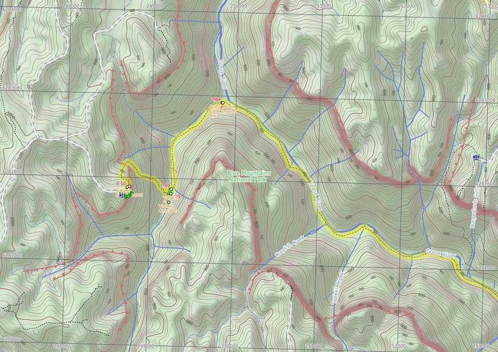
1 Victoria Falls Lookout to Blue Gum Forest 8 hrs Experienced only 13.8 km One way 5 112m This long day-walk follows a remote track down from Victoria Falls lookout, passing the waterfall, and into the Grose Valley, to the famous Blue Gum Forest, a scenic and historic highlight of this area. From the Blue Gum Forest, the walk climbs steeply to finish at Perry's Lookdown. You will need to organise a car shuttle, or a taxi for this walk. 961m 31m Blue Mountains National Park Maps, text & images are copyright wildwalks.com Thanks to OSM, NASA and others for data used to generate some map layers.

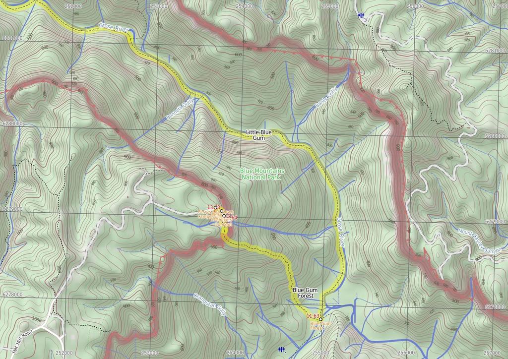
2 Victoria Falls Lookout Before You walk Victoria Falls Lookout, Blue Mountains NP, has an easterly aspect over the Grose Valley. Although the lookout is named after the wonderful Victoria Falls, there are no views of the falls from this lookout. Bushwalking is fun and a wonderful way to enjoy our natural places. Sometimes things go bad, with a bit of planning you can increase your chance of having an ejoyable and safer walk. Before setting off on your walk check Victoria Cascades Victoria Cascades, Blue Mountains NP, is a shorter run of water than the larger Victoria Falls. These cascades rush over a slope of rock to continue down to Victoria Falls. The cascades, made by Victoria Creek, are worth a look on your way down to Victoria Falls. However, on a a trip up from Victoria Falls, these smaller cascades may be somewhat overshadowed by the larger falls. Victoria Falls Victoria Falls, Blue Mountains NP, is a large waterfall dropping over a grey rock overhang. The cascade is produced by Victoria Creek dropping over the approximately-15m cliffs. A scree slope leads up behind the falls, and below the falls the rocks are very slippery. These falls are well worth a visit, with the great views from the top of the falls, and the accessibility of the bottom of the falls, making a great trip. Burra Korain Flat Camping Area Burra Korain Flat Camping Area, Blue Mountains NP, is a small clearing between the Victoria Creek and Grose River. The campsite is well signposted and has nice sitting logs and plenty of space for a few tents. Water can be accessed from either river or creek but should be treated before use. Blue Gum Forest Blue Gum Forest, Blue Mountains NP, is a large stand of Eucalyptus deanei trees on the junction of the Grose River and Govetts Creek. The magnificent trees stand tall on the flats with low vegetation beneath. The trees of Blue Gum Forest represent the protection efforts of Myles Dunphy, who lead a group to raise the 13 pounds required to buy the Blue Gum Forest - quite a sum in 1931 during the depression - and save it from being cleared. The group were successful and the Blue Gum Forest is now protected within the Blue Mountains National Park. More info. Dockers Lookout Dockers Lookout, Blue Mountains NP, has views over the Grose Valley and Blue Gum Forest below. Mt Banks can be seen standing proudly to the north above the valley. 1) Weather Forecast (BOM Central Tablelands District) 2) Fire Dangers (Central Ranges, Greater Sydney Region) 3) Park Alerts (Blue Mountains National Park) 4) Research the walk to check your party has the skills, fitness and equipment required 5) Agree to stay as a group and not leave anyone to walk solo Think before you TREK The 'Think before you TREK' program developed by NSW Police & NPWS promotes the benefits of planning ahead for your bushwalking trip by using an easy to remember acronym: adequate supplies of food, water, navigation and first T Take aid equipment. your planned route and tell friends and family when R Register you expect to return. beacon (PLB's) should be carried on walks with E Emergency significant gaps in mobile coverage (check terrain profile). to your planned route and follow the map and walking K Keep trails. Grade This walk has been graded using the AS The overall grade of the walk is dertermined by the highest classification along the whole track. 5 Grade 5/6 Experienced only Length 13.8 km One way Time 8 hrs Quality of track Rough unclear track (5/6) Signs Minimal directional signs (4/6) Experience Required Some bushwalking experience recommended (3/6) Weather Weather generally has little impact on safety (1/6) Infrastructure Limited facilities (such as cliffs not fenced, significant creeks not bridged) (4/6) Topo Maps The maps provided on wildwalks are helpful, but there are times where you may need maps covering a broader area. Maps that cover this walk include; 1:25 Map Series:8931N MOUNT WILSON 1:1 Map Series:893 KATOOMBA * This walk passes through very remote areas and sections have no visible track. At least one person in your group should have training and experience in off track walking and navigation. Even with these notes and a GPS these extra skills and equipment are required.
3 Are you ready to have fun? Please ensure you and your group are well prepared and equipped for all possible hazards and delays. Check park closures, weather information and Fire Danger Rating before setting out. Optional side trips and alternate routes noted are not included in this walks overall grade, length or time estimate. Please allow extra time for resting and exploring areas of interest. The authors, staff and owners of wildwalks take care in preparing this information but will not accept responsibility for any inconvenience, loss or injury you may experience. Please take care, have fun - Happy Walking. Experainced walkers only: This walk passes through very remote areas and sections have no visible track. At least one person in your group should have training and experience in off track walking and navigation. Even with these notes and a GPS these extra skills and equipment are required. Getting there Traveling by car is the only practical way to get to Victoria Falls Rd car park (gps: , ). Car: There is free parking available. Traveling by car is the only practical way to get back from Perry's Lookdown car park and camping area (gps: , ). Car: There is free parking available. Find up to date and more information inlcuding; travel directions, weather, park closures and walker feedback at Victoria Falls Rd car park (1 m ) From the car park, this walk follows the sign to 'Grose Valley Lookout' down the hill. The walk then winds down some steps for approximately 5m to a lookout..1 Victoria Falls Lookout Victoria Falls Lookout, Blue Mountains NP, has an easterly aspect over the Grose Valley. Although the lookout is named after the wonderful Victoria Falls, there are no views of the falls from this lookout..1 Victoria Falls Lookout (1.3 km 39 mins) Continue straight: From the lookout, this walk heads past the 'Victoria Falls' sign, down the hill. It leads across the hill for a short while before turning right and following the steps downhill for approximately 1m. The track then tends left, steeply down through a rocky outcrop, then continues winding across the hill under rocky outcrops (on the right). The track winds left, down through the rock again, to steeply zigzag down the hill for some time, moving away from the rocky outcrop, into ferns and more grassy undergrowth. The track heads steeply down towards the sound of the cascades at the signposted intersection Optional sidetrip to Victoria Creek Cascades (9 m 3 mins) Veer right: From the intersection, this walk follows the sign to 'Cascades', heading towards the noise of the falling water. It follows the hillside through the rainforest vegetation to the creek bank. The track then continues over the slippery rocks to the bottom of the falls. At the end of this side trip, retrace your steps back to the main walk then Veer right Victoria Cascades Victoria Cascades, Blue Mountains NP, is a shorter run of water than the larger Victoria Falls. These cascades rush over a slope of rock to continue down to Victoria Falls. The cascades, made by Victoria Creek, are worth a look on your way down to Victoria Falls. However, on a a trip up from Victoria Falls, these smaller cascades may be somewhat overshadowed by the larger falls Int. Victoria Creek Cascades and Victoria Falls Tr (2 m ) Turn left: From the intersection, this walk follows the sign to 'Burra Korain Flat', heading down the stairs for a short distance to another signposted intersection Optional sidetrip to Top of Falls (2 m 1 mins) Turn sharp right: From the intersection, this walk follows the 'Top of Falls' sign, down the hill to Victoria Creek. The track then turns left, descending steeply on some rocks. This walk continues downstream along a rockshelf to the top of Victoria Falls. At the end of this side trip, retrace your steps back to the main walk then Continue straight Int. Top of Falls and Victoria Creek Tracks (1 m ) Continue straight: From the intersection, this walk follows the sign to 'Burra Korain Flats' heading up the hill and then down to a railing, overlooking the Victoria Falls. The track then winds down the slippery hillside, descending to an intersection in front of a large, mossy rock Optional sidetrip to Victoria Falls (5 m ) Veer right: From the intersection, the track follows the hillside towards the sound of a waterfall, keeping the creek some distance below to your left. The track soon opens out onto the cliff of the waterfall. The track then swings around the right-hand side to go up the scree slope to venture behind the waterfall. At the end of this side trip, retrace your steps back to the main walk then Veer right Victoria Falls Victoria Falls, Blue Mountains NP, is a large waterfall dropping over a grey rock overhang. The cascade is produced by Victoria Creek dropping over the approximately-15m cliffs. A scree slope leads up behind the falls, and below the falls the rocks are very slippery. These falls are well worth a visit, with the great views from the top of the falls, and the accessibility of the bottom of the falls, making a great trip Int. Bottom of Falls and Victoria Creek Tracks (1.3 km 29 mins) Turn left: From the intersection, this walk follows the track downhill towards the creek, keeping the creek to you right, so soon come to a clearing beside the creek. Here the walk crosses the creek to find a sign pointing to 'Burra Korain Flat' (visible before crossing the creek). (This creek may be impassable after rain). The walk turns left to follow the 'Burra Korain Flat' sign downhill, keeping the creek to your left for over 1km. The track winds and undulating through ferns and rocky outcrops, to open out into the Burra Korain Flat Camping Area, which is signposted Burra Korain Flat Camping Area Burra Korain Flat Camping Area, Blue Mountains NP, is a small clearing between the Victoria Creek and Grose River. The campsite is well signposted and has nice sitting logs and plenty of space for a few tents. Water can be accessed from either river or creek but should be treated before use Burra Korain Flat Camping Area (8.8 km 3 hrs 24 mins) Continue straight: From the campsite, this walk heads down the hill to the creek and then across it. The track continues up through a grassy area to a clearing with a fireplace and BBQ and a sign to 'Acacia Flat'. Continue straight: From the camping area, this walk follows the 'Acacia Flats' sign down to the creek. The track crosses the creek and continues along the right-hand bank, heading downstream. The track then undulates and winds on the right side of the creek for approximately 3km in a south-easterly direction. The track crosses a number of creeks, and continues undulating along the south side of the Grose River to an intersection, with a sign pointing back to Burra Korain. Continue straight: From the intersection, this walk follows the sign to 'Acacia Flats', keeping the creek below on the left. The track continues for approximately 5m, undulating across the steep hillside. The terrain then begins to flatten out as the track leads onto a creek flat area. After a short while, a clearing with a fireplace is passed, on your right. The track continues to undulate along the hillside, with the creek to the left, for approximately 2km, to an area where the creek flats broaden. The track passes some more clearings with fire places, coming to a sign marked 'Blue Gum Forest'. The track passes this sign and continues for approximately 5m to a well-signed intersection Blue Gum Forest Blue Gum Forest, Blue Mountains NP, is a large stand of Eucalyptus deanei trees on the junction of the Grose River and Govetts Creek. The magnificent trees stand tall on the flats with low vegetation beneath. The trees of Blue Gum Forest represent the protection efforts of Myles Dunphy, who lead a group to raise the 13 pounds required to buy the Blue Gum Forest - quite a sum in 1931 during the depression - and save it from being cleared. The group were successful and the Blue Gum Forest is now protected within the Blue Mountains National Park. More info Blue Gum Forest intersection (2 km 1 hr 31 mins) Turn right: From the intersection, the walk follows the 'Perrys Lookdown Track' sign up the hill. The track heads uphill out of Blue Gum Forest, before tending right to more steeply climb the hill. As the track tends right, it heads up to the spur. When the track joins the spur, it turns left and heads up and continues winding for some time. The track continues up the spur to the cliffline, where it meets a set of steps and handrails. The walk climbs up large, steep steps, winding up through the pass to a memorial lookout at the top of the cliff. Continue straight: From Memorial Lookout, the walk climbs the stairs, keeping the valley on the right, and then contours left around the hill. The track descends slightly before crossing a bridge, and then turns right before leading up the steps to the signposted intersection Optional sidetrip to Dockers Lookout (2 m 1 mins) Veer right: From the intersection, the walk leads for a short distance down the railed path to the visible lookout area, Docker's Lookout. At the end of this side trip, retrace your steps back to the main walk then Continue straight Dockers Lookout Dockers Lookout, Blue Mountains NP, has views over the Grose Valley and Blue Gum Forest below. Mt Banks can be seen standing proudly to the north above the valley Int. Perry's and Dockers Lookout Tracks (4 m ) Turn sharp left: From the intersection, the walk follows the railed stairs up the hill for a short time until coming to Perry's Lookdown the lookout on the right Perry's Lookdown Perry's Lookdown, Blue Mountains NP, has views over the Grose Valley, with Blue Gum Forest nearly directly below and Lockleys Pylon to the south. The lookout is presumably named after Captain William Perry, the Deputy Surveyor General who worked under the leadership of Sir Thomas Mitchell Perry's Lookdown (8 m 3 mins) Continue straight: From the lookout, the walk leads up the stairs (leaving the valley behind) to the dirt road and car park Perrys Lookdown campground Perrys Lookdown offers a simple campsite, close to some spectacular
.")
4 lookouts and well located as starting point for longer walks exploring the Grose Valley. There are 5 tent sites and a non-flush toilet, but no water available. This area allows fuel stoves only (no camp fires). The camping area is a short walk from the car park. Limit to one night stay (sites cannot be reserved).
5
6
7 Summary navigation sheet for the Victoria Falls Lookout to Blue Gum Forest km From Start Victoria Falls Rd car park , (GR Mount Wilson, ).1 Victoria Falls Lookout , (GR Mount Wilson, ) 1.38 Int. Victoria Creek Cascades and Victoria Falls Tracks , (GR Mount Wilson, ) 1.38 Int. Victoria Creek Cascades and Victoria Falls Tracks , (GR Mount Wilson, ) 1.39 Int. Top of Falls and Victoria Creek Tracks , (GR Mount Wilson, ) Int. Top of Falls and Victoria Creek Tracks , (GR Mount Wilson, ) Int. Bottom of Falls and Victoria Creek Tracks , (GR Mount Wilson, ) Int. Bottom of Falls and Victoria Creek Tracks , (GR Mount Wilson, ) Burra Korain Flat Camping Area , (GR Mount Wilson, ) Blue Gum Forest intersection , (GR Mount Wilson, 55778) Int. Perry's and Dockers Lookout Tracks -33.6, (GR Mount Wilson, 53879) Int. Perry's and Dockers Lookout Tracks -33.6, (GR Mount Wilson, 53879) Perry's Lookdown , (GR Mount Wilson, ) Powered by TCPDF ( Up/Dwn Length Initial directions (Use full tracknotes and maps for more detail) m 1.3 km 39 mins 9 m 3 mins 2 m 1 2 m -1 1 mins 1 m m km mins km hrs 24 mins 63 2 km hr 31 mins 2 m mins 15 4 m 16 8 m 3 mins From the car park, this walk follows the sign to 'Grose Valley Lookout' down the hill. Continue straight: From the lookout, this walk heads past the 'Victoria Falls' sign, down the hill. Optional sidetrip to Victoria Creek Cascades. Veer right: From the intersection, this walk follows the sign to 'Cascades', heading towards the noise of the falling water. Turn left: From the intersection, this walk follows the sign to 'Burra Korain Flat', heading down the stairs for a short distance to another signposted intersection. Optional sidetrip to Top of Falls. Turn sharp right: From the intersection, this walk follows the 'Top of Falls' sign, down the hill to Victoria Creek. Continue straight: From the intersection, this walk follows the sign to 'Burra Korain Flats' heading up the hill and then down to a railing, overlooking the Victoria Falls. Optional sidetrip to Victoria Falls. Veer right: From the intersection, the track follows the hillside towards the sound of a waterfall, keeping the creek some distance below to your left. Turn left: From the intersection, this walk follows the track downhill towards the creek, keeping the creek to you right, so soon come to a clearing beside the creek. Continue straight: From the campsite, this walk heads down the hill to the creek and then across it. Turn right: From the intersection, the walk follows the 'Perrys Lookdown Track' sign up the hill. Optional sidetrip to Dockers Lookout. Veer right: From the intersection, the walk leads for a short distance down the railed path to the visible lookout area, Docker's Lookout. Turn sharp left: From the intersection, the walk follows the railed stairs up the hill for a short time until coming to Perry's Lookdown - the lookout on the right. Continue straight: From the lookout, the walk leads up the stairs (leaving the valley behind) to the dirt road and car park.
Victoria Falls and Grose Valley to Blackheath Station
 Victoria Falls and Grose Valley to Blackheath Station 3 Days Experienced only 22.5 km One way 5 158m This walk explores a fantastic section of the Grose Valley. Starting above Victoria Falls, the walk
Victoria Falls to Blackheath Station
 Victoria Falls to Blackheath Station 2 Days Experienced only 22.2 km One way 5 1561m This is a fantastic overnight walk with a sleep in Acacia Flats camping area. The Grose Valley, with its views of the
Victoria Falls and Grose Valley to Blackheath Station
 This walk explores a fantastic section of the Grose Valley. Starting above Victoria Falls, the walk explores the cascades before dropping into the valley for the first nights rest at Burra Korain campsite.
Leura Cascades to Gordon Falls Reserve
 Leura Cascades to Gordon Falls Reserve 1 hr 15 mins 1.8 km One way Moderate track 200m From Leura Park to Gordon Falls Park, this diverse walk offers fantastic views of the Jamison Valley, as well as two
Nature Track. 900m. 789m. 2 hrs 3.1 km Circuit. Hard track 238m. Blue Mountains National Park
 Nature Track 2 hrs 3.1 km Circuit Hard track 238m Largely following the ridges around the top edge of Wentworth Falls, this track is incredibly beautiful. After taking in the great views at Edinburgh Castle
Blackheath to Blue Gum loop
 Blackheath to Blue Gum loop 2 Days Hard track 24.1 km Circuit 4 1335m This walk is great for fit people getting into overnight walking, with its fantastic scenery and nostalgia as a classic overnighter.
Erskine Creek via Pisgah Rock and Jack Evans
 Erskine Creek via Pisgah Rock and Jack Evans 4 hrs 30 mins 7.1 km Circuit Very experienced only 6 421m This walk visits some great lookouts and explores the lower section of Erskine Creek. Most of the
Congewai Track Head (East) to Watagan Headquarters
 to Watagan Headquarters") Congewai Track Head (East) to Watagan Headquarters 7 hrs Hard track 17.2 km One way 4 973m This full day walk starts from the Congewai valley trackhead (east) and follows the Great North Walk up into the
Congewai Track Head (East) to Watagan Headquarters 7 hrs Hard track 17.2 km One way 4 973m This full day walk starts from the Congewai valley trackhead (east) and follows the Great North Walk up into the
Abbotts Falls Walking Track
 Abbotts Falls Walking Track 3 hrs 7.3 km Circuit Hard track 329m This circuit takes you through both dry and moist forest, using a combination of walking trails and wider tracks. The side trip to the dammed
Guthega to Mt Twynam. 2183m. 1583m. 6 hrs 45 mins 14.8 km Return. Experienced only. 913m
 Guthega to Mt Twynam 6 hrs 45 mins 14.8 km Return Experienced only 5 913m This walk starts from Guthega and makes its way along the Snowy River to the Illawong Lodge, via the Blue Cow Creek flying fox.
Merritts Traverse. 1928m
 Merritts Traverse 3 hrs Hard track 5.8 km Circuit 4 167m This walk starts with a scenic journey to the top of the hill on the chairlift. Starting along Merritts Nature walk, this walk soon detours down
Staples Lookout to Mt Wondabyne loop
 Staples Lookout to Mt Wondabyne loop 4 hrs 3 mins 1.8 km Circuit Hard track 337m This walk starts and finishes at Staples Lookout, on Woy Woy Rd. The walk follows sections of the Great North Walk around
Mt Kuring-gai Track to Berowra station
 Mt Kuring-gai Track to Berowra station 4 hrs 15 mins 9.7 km One way Hard track 4 553m This walk explores three valleys, with great displays of wild flowers in spring, and some nice sandstone overhangs.
National Pass. 893m. 665m. 3 hrs 30 mins 4.6 km Circuit. Hard track 773m. Blue Mountains National Park
 National Pass 3 hrs 3 mins 4.6 km Circuit Hard track 773m 4 This walk offers fantastic views of the Jamison Valley and the surrounding cliffs. Take time to explore the historic and very scenic ledge halfway
Wentworth Pass. 893m. 535m. 4 hrs. Hard track 5.1 km Circuit. 692m
 Wentworth Pass 4 hrs Hard track 5.1 km Circuit 4 692m This walk offers a great way to explore the magical, upper section of the Valley of the Waters. The walk starts and finishes at Conservation Hut, which
Berowra Waters to Cowan Station
 Berowra Waters to Cowan Station 3 hrs 30 mins 7.2 km One way Hard track 597m This is a hilly walk out of the beautiful Berowra Waters valley to Cowan Station. There are many wide views across Berowra Creek
Dadder Cave and Jack Evans track
 Dadder Cave and Jack Evans track 2 Days 10.3 km Circuit Very experienced only 535m This fairly short overnight walk is a great way to explore Erskine Creek. The walking along Erskine creek is mostly off
Scenic Railway to Ruined Castle
 Scenic Railway to Ruined Castle 7 hrs 30 mins 12.4 km Return Hard track 4 963m This is a very popular, full day walk, in the Katoomba Area, offering great views of the valley. The walk follows the edge
Girrakool to Wondabyne station
 Girrakool to Wondabyne station 4 hrs Hard track 9.5 km One way 4 438m This walk starts from the Girrakool picnic area and winds south, through the Brisbane Waters National Park. The walk crosses some long
Jerusalem Bay Track (Cowan to Brooklyn)
") Jerusalem Bay Track (Cowan to Brooklyn) 5 hrs 30 mins 13.4 km One way Hard track 4 654m This Cowan to Brooklyn Station walk is a popular section of the Great North Walk, with scenery ranging from foreshore
Jerusalem Bay Track (Cowan to Brooklyn) 5 hrs 30 mins 13.4 km One way Hard track 4 654m This Cowan to Brooklyn Station walk is a popular section of the Great North Walk, with scenery ranging from foreshore
Girrakool to Wondabyne station via Pindar caves
 Girrakool to Wondabyne station via Pindar caves 7 hrs 30 mins 18.1 km One way Experienced only 5 741m This walk starts from the Girrakool picnic area and winds south, following Piles creek into the Brisbane
Berowra to Cowan via Berowra Waters
 Berowra to Cowan via Berowra Waters 6 hrs Hard track 12.9 km One way 4 884m With train station at each end this walk explores the ridges and valleys around Berowra Waters. There are plenty of excellent
Main Range Track - Loop from Charlotte Pass camping near Mt Townsend
 Main Range Track - Loop from Charlotte Pass camping near Mt Townsend 2 Days Experienced only 27.7 km Circuit 5 1260m This great overnight walk starts from Charlotte Pass and provides access to some of
Main Range Walk - Charlotte Pass to Mount Kosciuszko
 Main Range Walk - Charlotte Pass to Mount Kosciuszko 9 hrs Hard track 21.9 km Circuit 4 920m This full day walk explores some of the greatest alpine country on offer in NSW. The walk grants views of Blue,
Leura to Katoomba via Dardanelles Pass
 Leura to Katoomba via Dardanelles Pass 4 hrs 6.6 km One way Hard track 697m With approximately equal parts cliff-walk and forest track, this track truly shows what the cliff edges of the Jamison Valley
Lady Carrington Drive
 Lady Carrington Drive 3 hrs 45 mins 9.7 km One way Moderate track 3 266m This walk follows the historic Lady Carrington Drive alongside the Hacking River. The old road is closed to traffic and provides
Gibberagong Track. 169m
 Gibberagong Track 2 hrs 30 mins 6.5 km One way Hard track 4 180m Starting in suburban Wahroonga, this wellmaintained track follows Cockle Creek down to Bobbin Head in the Ku-ring-gai Chase National Park.
Crosslands to Berowra Waters return
 Crosslands to Berowra Waters return 6 hrs Hard track 13.7 km Return 4 1005m This return walk starts from the Crosslands Reserve and follows the Great North Walk along Berowra creek. The walk includes some
Hornsby station to Crosslands
 Hornsby station to Crosslands 6 hrs 45 mins 16.1 km One way Hard track 4 938m This section of the Great North Walk starts from Hornsby train station and winds down along the Blue Gum Walk into Fishponds.
Crosslands to Cowan. 220m
 Crosslands to Cowan 7 hrs 30 mins 14 km One way Hard track 4 1103m This section of the Great North Walk starts from the Crosslands camping area and winds north alongside Berowra creek, passing through
The Prince Henry Cliff Walk
 The Prince Henry Cliff Walk 3 hrs 30 mins 6.8 km One way Moderate track 3 575m Going from Katoomba to Leura, this walk covers the top of the cliff line and most of the major lookouts. With brilliant vistas
Katoomba to Wentworth Falls via the Jamison Valley
 Katoomba to Wentworth Falls via the Jamison Valley 2 Days Experienced only 29.2 km One way 5 2135m This is the two day version of this popular and challenging walk. This walk passes popular sights including
Patonga to Staples Lookout
 Patonga to Staples Lookout 6 hrs 3 mins 17 km One way Hard track 4 72m This great walk explores much of the main ridge ridge running through Brisbane Water National Park. The walk visits a number of great
Somersby to Yarramalong via Stringy Bark Point
 Somersby to Yarramalong via Stringy Bark Point 2 Days Hard track 26.7 km One way 4 1201m This section of the Great North Walk starts form the Somersby General Store and follows the Great North Walk north
Guthega to Thredbo camping overnight at Wilkensons Creek
 Guthega to Thredbo camping overnight at Wilkensons Creek 2 Days Experienced only 25.8 km One way 5 1364m This great overnight walk explores the Kosciusko National Park between Guthega and Thredbo, visiting
Patonga to Wondabyne station via Mt Wondabyne
 Patonga to Wondabyne station via Mt Wondabyne 7 hrs 3 mins 19.5 km One way Hard track 4 861m This walk explores some grand views, pleasant cascades, varied bushland and remote areas of Brisbane Waters
Berowra to Hornsby. 9 hrs 18 mins 22.6 km One way. Hard track. 1423m
 Berowra to Hornsby 9 hrs 18 mins 22.6 km One way Hard track 4 1423m One of the longer day walks in Berowra Valley National Park, this walk mostly follows Berowra Creek along the Great North Walk. Excellent
Patonga to Wondabyne station via Pindar Caves overnight
 Patonga to Wondabyne station via Pindar Caves overnight 2 Days Experienced only 28.1 km One way 5 1164m This overnight hike starts from Patonga beach and winds along a section of the Great North Walk,
Main Range Circuit from Guthega
 Main Range Circuit from Guthega 4 Days Experienced only 45 km Circuit 5 2317m This four day walk explores the Kosciuszko National Park, covering many of the key features of the park between Guthega and
Wondabyne station to Somersby Store
 Wondabyne station to Somersby Store 10 hrs Hard track 26.2 km One way 4 1164m This walk, following a section of the Great North Walk, starts from the Wondabyne train station and winds north, into the Brisbane
Somersby to the Basin Campsite
 Somersby to the Basin Campsite 3 Days Hard track 47.4 km One way 4 2032m This three day walk starts at the Somersby General Store and follows the Great North Walk, heading north, into the the Jilliby State
Cowan to Wondabyne station via Patonga rest area
 Cowan to Wondabyne station via Patonga rest area 2 Days Hard track 33.4 km One way 4 1523m This section of the Great North Walk starts from Cowan train station and wanders past the majestic Jerusalem Bay
Crosslands to Brooklyn
 Crosslands to Brooklyn 2 Days Hard track 27.4 km One way 4 1757m From the Crosslands Reserve, this walk heads along the Great North Walk via Berowra Waters, Cowan, Jerusalem Bay and onto Brooklyn. This
Western Commission Track to Dubbo Gully
 This two day walk follows a series of historic roads along clear and wide management trails. This walk explores the great views from Western Commission Track, the sandstone handicraft on the Old Great
Out and about at Geehi
 Geehi Geehi Flats is a large area of flat floodplain on the banks of the Swampy Plains River. Located within Kosciuszko National Park, it is home to a popular campsite in summer for people wanting to enjoy
Gordon to Hornsby (overnight at Scout camp)
") Gordon to Hornsby (overnight at Scout camp) 2 Days Hard track 25.8 km One way 4 125m This overnight walk starts from Gordon train station and winds through bush filled valleys to Hornsby station. From
Gordon to Hornsby (overnight at Scout camp) 2 Days Hard track 25.8 km One way 4 125m This overnight walk starts from Gordon train station and winds through bush filled valleys to Hornsby station. From
Thornleigh to Cowan. 2 Days. Hard track 35.9 km One way. 2337m
 Thornleigh to Cowan 2 Days Hard track 35.9 km One way 4 2337m Following the Great North Walk and Berowra Creek through Berowra Valley Regional Park, this walk cuts straight through the length of the Park.
GOLDEN EARS PROVINCIAL PARK
 GOLDEN EARS PROVINCIAL PARK Trail Information as of October 10 th 2015 Do not underestimate the mountainous wilderness of Golden Ears Provincial Park. The combination of rugged terrain and rapidly changing
Sponsored by. statestreet.com
 /STATESTREETISLANDWALK #ISLANDWALKJSY Sponsored by statestreet.com Important Information If you forget everything else PLEASE remember the following.» Remember to check OUT of every checkpoint» If you
Location: Height: Access: Distance: Elevation: Season: Difficulty: Lat/Long: Directions:
 Upper Eagle Falls Upper Eagle Falls (~20 ft.) is a short hike up from the roadside at the Eagle Falls picnic area. It is very difficult to get a parking spot here during the day, so it is recommended to
beach. Make the ford and follow the trail out to the junction with Red Creek Tr in an open grassy area.
 Description: This is a moderate to slightly strenuous 22.8 mile backpack (add 2.6 miles if you do the packless out and back to the Lion s Head) that will have you exploring nearly every thing that is The
The Mendip Way. Route Directions and Maps Uphill to Wells
 The Mendip Way Route Directions and Maps Uphill to Wells Website: www.mendiphillsaonb.org.uk Email: mendip@mendiphillsaonb.org.uk Facebook & Twitter: @MendipHillsAONB Phone: 01761462338 1 Uphill to Loxton
Leaden Boot Challenge ROUTE INSTRUCTIONS
 Leaden Boot Challenge ROUTE INSTRUCTIONS Section 1 Alstonefield to Ilam From the village hall car park turn R then L and pass through the village keeping to the R to enter Church Street. Pass the Church
TREK THE ROCKIES ABOUT THE CHALLENGE TREK THE ROCKIES FOR HIGHLAND HOSPICE CANADA TREK DEMANDING
 TREK THE ROCKIES CANADA TREK DEMANDING ABOUT THE CHALLENGE The Canadian Rockies are justifiably world-famous for their magnificent scenery: the combination of impressive, jagged mountains, bright turquoise
Leaden Boot Challenge 2016 ROUTE INSTRUCTIONS
 Leaden Boot Challenge 2016 ROUTE INSTRUCTIONS Section 1 Alstonefield to Ilam (CP2) From the village hall car park turn R then L and pass through the village keeping to the R to enter Church Street. Pass
1. Waterfall Gully Mt Lofty. 5 Of the Best Hikes in Adelaide
 Adelaide is a beautiful city, and one of the most incredible things about Adelaide is the quality of bushwalking available on the suburban fringe. It is surrounded by the Mt Lofty Ranges, and much of the
Hindhead, Keffolds Copse and Gibbet Hill
 point your feet on a new path, Keffolds Copse and Gibbet Hill Distance: 6 km=4 miles Region: Surrey Author: Schwebefuss Refreshments: Punch Bowl Café moderate walking Date written: 14-apr-2015 Last update:
COSTA BLANCA MOUNTAIN WALKERS - WALK DESCRIPTION. Visit for more walks descriptions in Spain
 COSTA BLANCA MOUNTAIN WALKERS - WALK DESCRIPTION Visit www.walksinspain.org for more walks descriptions in Spain Walk description originally prepared by:- Ralph Phipps Last Updated 25th Sep 2015 Title
TUPPER DESIGNATED ACCESS ROUTE
 TUPPER DESIGNATED ACCESS ROUTE 1 FOR ACCESS/EGRESS TO CONNAUGHT, LOOKOUT, STONE ARCH, PORTAL PATHS AND TUPPER TRAVERSE EGRESS Length: 2.6km Vertical Gain: +162m / -83m (Values are for access. For egress,
Charnley Explorer June 24 - July 15, 2018 Bachsten Creek and the Charnley River. Second draft: 14 November 2017
 Charnley Explorer June 24 - July 15, 2018 Bachsten Creek and the Charnley River. Second draft: 14 November 2017 The best part of the original section one is now part of out Gibb Road Gorges trip. The dates
HIKING IN THE CANADIAN ROCKIES
 HIKING IN THE CANADIAN ROCKIES Distance Time Elevation y MORAINE LAKE TRAILS THE ROCKPILE 0.8 km (0.5 mi) 20 min 30 m (98 ft) Located adjacent to the Lodge, the short interpretive trail up the Rock Pile
Tiger Mountain State Forest:
 98 60 hikes within 60 miles: SEATTLE 20 Tiger Mountain State Forest: West Tiger Mountain Three Loop i KEY AT-A-GLANCE INFORMATION Length: 5.1 miles round-trip Configuration: Loop Difficulty: Moderate difficult
East West route and Leatham Molesworth route (route guide) Molesworth Recreation Reserve
 Molesworth Recreation Reserve") East West route and Leatham Molesworth route (route guide) Molesworth Recreation Reserve 0BIntroduction The East West route links the Clarence (Kahutara River in Ka Whata Tu o Rakihouia) Conservation Park
East West route and Leatham Molesworth route (route guide) Molesworth Recreation Reserve 0BIntroduction The East West route links the Clarence (Kahutara River in Ka Whata Tu o Rakihouia) Conservation Park
Beautiful Walks from the Blue Ball Inn
 Walk No. 5 RIVER VALLEYS AND MOOR Countisbury, Watersmeet, Hillsford Bridge, Cheriton, Shilstone Hill, Rockford and Chiselcombe. 8.5 MILES APPROX. Walking time four and a half hours approx. OS 1;25,000
Self-Guided Walk Langdale Pikes. Start & Finish: NT car park (free to members) at Sticklebarn - on the right just beyond the New Dungeon Ghyll hotel.
 at Sticklebarn - on the right just beyond the New Dungeon Ghyll hotel.") Self-Guided Walk Langdale Pikes Key Information These mountains form a collection of spires and cliffs on the north side of Langdale. This walk visits four of the main tops Pavey Ark, Harrison Stickle,
Self-Guided Walk Langdale Pikes Key Information These mountains form a collection of spires and cliffs on the north side of Langdale. This walk visits four of the main tops Pavey Ark, Harrison Stickle,
A CENTURY OF CONSERVATION Dunphys kowmung adventure 2014 SEPTEMBER 26TH TO OCTOBER 6TH KATOOMBA TO PICTON
 A CENTURY OF CONSERVATION 1914-2014 Dunphys kowmung adventure 2014 SEPTEMBER 26TH TO OCTOBER 6TH KATOOMBA TO PICTON Stage 3 Uni Rover Trail to Yerranderie September 30 to October 1 2014 th st DUNPHY S
Photographing Upper Peninsula Waterfalls
 Photographing Upper Peninsula Waterfalls Tod Poirier Freelance Photographer Photography is one of my passions. The following spread showcases several Upper Peninsula waterfalls. At times a single drop
Rogue Gorge (Mt. Stella) Roadless Area-- T30S R3E (primarily in portions of Sections 23, 26, 33, 34 & 35)
 Roadless Area-- T30S R3E (primarily in portions of Sections 23, 26, 33, 34 & 35)") Rogue Gorge (Mt. Stella) Roadless Area-- T30S R3E (primarily in portions of Sections 23, 26, 33, 34 & 35) Rogue River-Siskiyou National Forest--High Cascades Ranger District Upper, higher elevation trail
Rogue Gorge (Mt. Stella) Roadless Area-- T30S R3E (primarily in portions of Sections 23, 26, 33, 34 & 35) Rogue River-Siskiyou National Forest--High Cascades Ranger District Upper, higher elevation trail
CWMGIEDD FROM ABERCRAVE
 Abercrave to Cwmgiedd Walk Page 1 Starting from The Abercrave Inn. Grid Ref: SN 824128 From the Abercrave Inn, an 11.3km (7 miles) walk to the foothills of the Cribarth Mountain, then through forest to
Tumbler Ridge Global Geopark
 Tumbler Ridge Global Geopark WILDERNESS WATERFALLS These waterfalls are in remote locations, no trails exist, and GPS is required. Not every geosite needs a hiking trail. Providing ready access to all
GIFFORD PINCHOT NATIONAL FOREST
 GIFFORD PINCHOT NATIONAL FOREST 9341 Wright Meadow 93 Spencer Meadow Spencer Butte 4247' 30 30A 19 24 80 31C Lewis River Lower Falls 5 Quartz Creek 90 Taidnapam Falls Upper Falls 31 Spencer Peak 3861'
Gunung Stong trekking log
 Gunung Stong trekking log Description of group We are a group of 13 average trekkers. (Gone on at least 2 treks before) Summary of activities 14 th May 2002: Depart on overnite train from JB to Dabong
Route #2) Mt. Massive - Southwest Slopes
 Mt. Massive - Southwest Slopes") Route #2) Mt. Massive - Southwest Slopes Difficulty: Class 2 Ski: Advanced, D6 / R2 / III Exposure: Summit Elevation: Trailhead Elevation: Elevation Gain: Round-trip Length: Trailhead: County Sheriff:
Route #2) Mt. Massive - Southwest Slopes Difficulty: Class 2 Ski: Advanced, D6 / R2 / III Exposure: Summit Elevation: Trailhead Elevation: Elevation Gain: Round-trip Length: Trailhead: County Sheriff:
Slad over to Pitchcombe and back
 The walk climbs up from Slad over Wickridge Hill, descends to near Pitchcombe, then climbs back over Wickridge hill and round the back of Slad. Page 1 Start Point: SO 8718 0732 The Woolpack, Slad Length:
Pontfadog. Walk A. Walk A
 Walk A A Bird s eye view of the village 2km. (1 1 /2 miles); height gain 45m. (150ft) about 45 minutes. Six minutes walk along the main road towards Glyn Ceiriog reach a signpost to Llwynmawr. Take the
BISHOPSTONE CIRCULAR WALK
 BISHOPSTONE CIRCULAR WALK 4½ miles (7¼ km) - allow 2 hours (see maps on final pages) Introduction This walk is within the North Wessex Downs Area of Outstanding Natural Beauty and starts from the small,
Note: Coordinates are provided as Universal Transverse Mercator UTM Zone U21, North American Datum 1983 (NAD 83).
.") Northern Traverse Route Description The Northern Traverse (formerly the North Rim Traverse) is an unmarked and rugged backcountry hiking route. It is known be a demanding hike, because of its terrain and
Northern Traverse Route Description The Northern Traverse (formerly the North Rim Traverse) is an unmarked and rugged backcountry hiking route. It is known be a demanding hike, because of its terrain and
Route #1) Mt. of the Holy Cross - North Ridge
 Mt. of the Holy Cross - North Ridge") Climbing 14ers can be very dangerous, please read the Mountaineering Safety Page and make sure you have a map+compass and can use them effectively, without the help of electronic devices. Route #1) Mt.
Climbing 14ers can be very dangerous, please read the Mountaineering Safety Page and make sure you have a map+compass and can use them effectively, without the help of electronic devices. Route #1) Mt.
Hadleigh Castle and Chalkwell Oaze
 1 Hadleigh Castle and Chalkwell Oaze Benfleet station Hadleigh Park Hadleigh Castle Leigh-on-Sea Chalkwell station A short stroll through the lush woods of Hadleigh Park high above the Thames-side marshes,
Illawarra Escarpment State Conservation Area Walking Tracks
 Illawarra Escarpment State Conservation Area Walking Tracks NPWS Illawarra Area Office Ground Floor, Government Office Block 84 Crown Street Wollongong NSW 2500 02 4223 3000 (Mon-Fri) Royal National Park
Wicklow Mountains Path Survey
 Wicklow Mountains Path Survey Ballinacor Croaghanmoira Fananierin Start to Finish: T 11723 86602 to T 11175 89057 Altitude (lowest highest): 385m 664m Weather: Hot Access: Coolgarrow forest entrance Surveyed
COSTA BLANCA MOUNTAIN WALKERS - WALK DESCRIPTION. Visit for more walks descriptions in Spain
 Visit www.walksinspain.org for more walks descriptions in Spain Walk description originally prepared by:- Ralph Phipps Last Updated 15 th July 2016 Title of Walk Location of Start (include name of nearest
Little Grand Canyon near Pomona, Illinois
 Little Grand Canyon near Pomona, Illinois Below: View of the trail and the terrain created using the Map My Hike app Below: Summary of the hike created using the Map My Hike app Presented by: Jennifer
Access. Road from start point (W01) to campground (W56) Water Taxi Pick-up (W03)
 to campground (W56) Water Taxi Pick-up (W03)") WAIKAREMOANA GREAT WALK 260 Series Map: W18 Waikaremoana NZ Grid GPS: Geodetic Datum 1949 Topo50 Maps: BG39 Ruatahuna & BG40 Waikaremoana Gaps: on WGS84 Topo250 Map: Sheet 10 To get to START: Exit Taupo
WAIKAREMOANA GREAT WALK 260 Series Map: W18 Waikaremoana NZ Grid GPS: Geodetic Datum 1949 Topo50 Maps: BG39 Ruatahuna & BG40 Waikaremoana Gaps: on WGS84 Topo250 Map: Sheet 10 To get to START: Exit Taupo
Bonaqua Mountain Hardware Action Sprint 2013 Discovery Bay,Lantau The Course Route
 Bonaqua Mountain Hardware Action Sprint 2013 Discovery Bay,Lantau The Course Route The start is inside the Discovery Bay plaza and leads out to the main sandy beach where you will run to the end of the
Section 7: Pick Up Where You Left Off! S-Tree Road over the Todd Road
 2018 TRACE NOTES Helpful information for your adventure on Section 7 of the Hiker Challenge. Start Point S-Tree Rd. End Point Intersection Todd Rd. / Hale Ridge Rd. WEATHER DECISION Weather Alert!!!! Potential
Compassionate Communication Bushwalking Retreat Wilderness and Connection
 Compassionate Communication Bushwalking Retreat Wilderness and Connection 25 th August- 1 st September 2018 The Ampitheatre, Twin Falls Creek This walk is both an exploration of magnificent country filled
Grizzly Peak A - East Ridge July 15, 2012
 Grizzly Peak A - East Ridge July 15, 2012 Difficulty: Difficult Class 2/Class 3 Upper Elevation: 13,995 feet Trailhead Elevation: 11,360 feet Elevation Gain: 3,000 feet Round-trip Length: 6.0 miles Trailhead:
COLOUR G U I D E. Sydney to Newcastle: Australia s most accessible long-distance walk
 COLOUR G U I D E Sydney to Newcastle: Australia s most accessible long-distance walk Woodslane Press Pty Ltd Unit 7/5 Vuko Place Warriewood, NSW 2102 Australia Email: info@woodslane.com.au Tel: (02)
middle left: Riversleigh fossils lower left: Constance Range images: Hj Preuss... Thx
 Upstreampaddle Summer 2008 18 middle left: Riversleigh fossils lower left: Constance Range images: Hj Preuss... Thx top right: road west of the Isa middle right: Constance Range lower right: rocky outcrop
Ala-Kul trekking guide.
 Ala-Kul trekking guide. The marshrutka 101 brings you to the entrance of the park. For 400 KGS, a taxi will stop between the entrance and the broken bridge, saving at least 1 hour of walk. Download me
Skiing and Snowshoes on Un-groomed Fernan Saddle Terrain
 Skiing and Snowshoes on Un-groomed Fernan Saddle Terrain Three ski or snowshoe routes are available from the Fernan Saddle Parking Lot which either do not cover routes ordinarily groomed for snow machine
Ribbon Cliff - Ribbon Mesa text and photos by Charlie Hickenbottom
 Ribbon Cliff - Ribbon Mesa text and photos by Charlie Hickenbottom Looking for something a little different than Sage Hills or Saddlerock? Perhaps something a little wilder, a little less traveled? Look
ID: 283 Distance: 6.2 miles Height gain: 500 Metres Map: Explore OL 19 Contributor David and Chris Stewart
 Walkingworld Wild Boar Fell ID: 283 Distance: 6.2 miles Height gain: 500 Metres Map: Explore OL 19 Contributor David and Chris Stewart Features Birds, Great Views, Hills or Fells Description: Wild Boar
Best Hikes on Orcas Island
 Published on San Juan Islands Washington Visitors Bureau Orcas Island Lopez Island Friday Harbor San Juan Island (https://www.visitsanjuans.com) Best Hikes on Orcas Island The Emerald Isle offers big trees,
San Miguel to Caserio de la Hoya Circular (San Miguel)
") Tenerife Sur: Short Walks Under 10 km San Miguel to Caserio de la Hoya Circular (San Miguel) Route Summary An informative and scenic walk back in time from San Miguel to below El Roque, overlooking the
Tenerife Sur: Short Walks Under 10 km San Miguel to Caserio de la Hoya Circular (San Miguel) Route Summary An informative and scenic walk back in time from San Miguel to below El Roque, overlooking the
Non-Violent Communication Bushwalking Retreat
 Non-Violent Communication Bushwalking Retreat Wilderness and Connection 25 th August- 1 st September 2018 The Ampitheatre, Twin Falls Creek This walk is both an exploration of magnificent country filled
Trail Phasing Plan. Note: Trails in the Clear Creek Canyon area (Segments will be finalized in the future to minimize wildlife impacts
 Note: Trails in the Clear Creek Canyon area (Segments 2 5 and a future JCOS connection) will be finalized in the future to minimize wildlife impacts Trail Phasing Plan P Parking 3 Easy Trail Intermediate
Our Murray River Beaches
 Page 1 of 5 Our Murray River Beaches Click here to print this page West of Yarrawonga are many access points to the river. Earth tracks lead from the Murray Valley Highway through state forests to picnic
Non-motorized Trail Plan & Proposal. August 8, 2014
 Town of Star Valley Ranch, Wyoming and the Star Valley Ranch Association in partnership with the USDA Forest Service, Bridger-Teton National Forest, Greys River Ranger District Non-motorized Trail Plan