Guthega to Mt Twynam. 2183m. 1583m. 6 hrs 45 mins 14.8 km Return. Experienced only. 913m
|
|
|
- Eric Ford
- 5 years ago
- Views:
Transcription


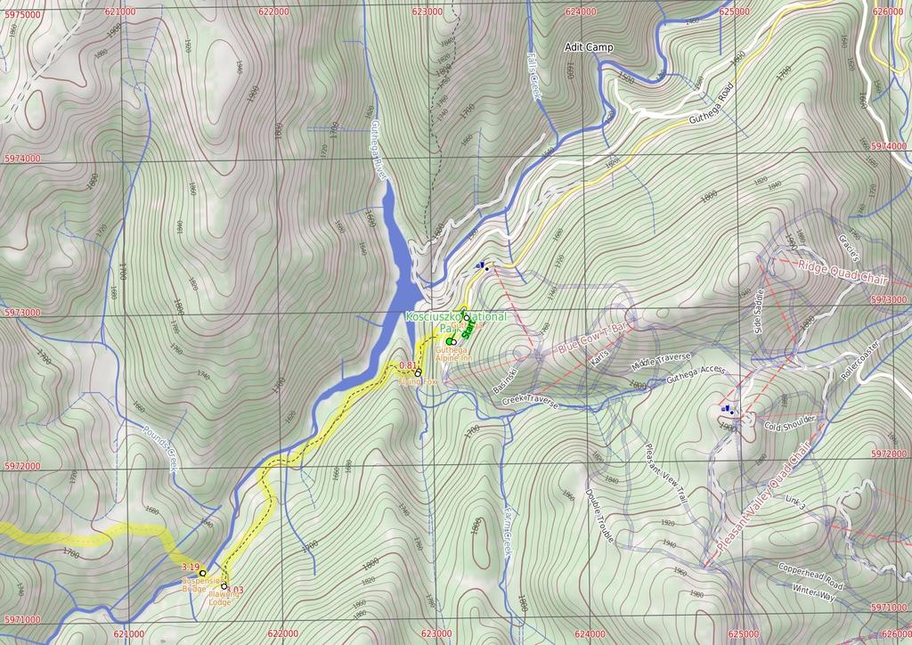
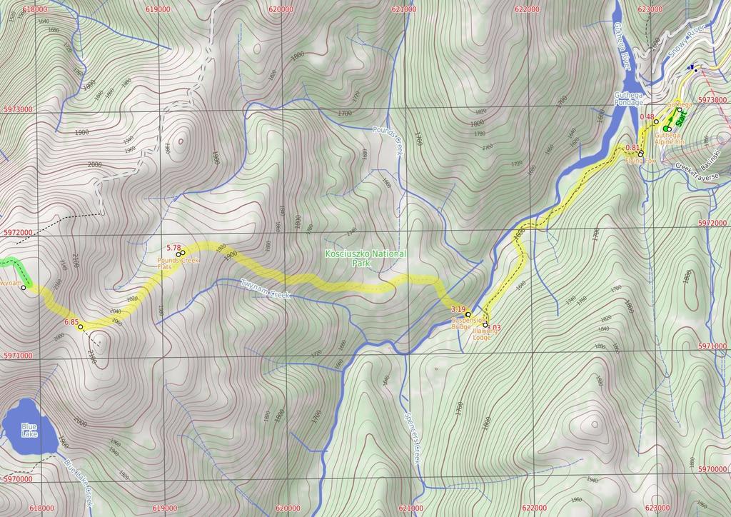
1 Guthega to Mt Twynam 6 hrs 45 mins 14.8 km Return Experienced only 5 913m This walk starts from Guthega and makes its way along the Snowy River to the Illawong Lodge, via the Blue Cow Creek flying fox. From the lodge, the walk crosses the suspension bridge and begins the climb up the ridge past Pounds Creek Flats to the top of Mt Twynam. From here, there is an optional side trip along the ridge line to a point with better views of the lake, before returning to Guthega. 2183m 1583m Kosciuszko National Park Maps, text & images are copyright wildwalks.com Thanks to OSM, NASA and others for data used to generate some map layers.

2 Covered in snow part of the year Before You walk This walk leads through an extreme alpine environment and all walkers must be well prepared. During summer, be prepared for both very hot and cold weather, high winds, rain, snow, extreme UV levels and some sections of snow or ice on the ground. Before starting this walk, check advice with Snowy Region Visitor Information Centre (2) , the weather forecast and the snow conditions then change your plans as needed. These notes, grades and walking times have been written for use in the summer months only. Between May and the end of October, this walk is likely to be covered in snow/ice, visitors should be carrying and be prepared to use snowshoes or cross country skis. When there is a chance of significant snow on the ground, visitors will need particularly strong navigation and snowcraft skills - tracks and signage may not be visible. For most visitors, it is best to consider this walk closed during the colder months. Bushwalking is fun and a wonderful way to enjoy our natural places. Sometimes things go bad, with a bit of planning you can increase your chance of having an ejoyable and safer walk. Before setting off on your walk check Guthega Guthega is a relatively small township, north of Perisher, and comprises mostly of hotel and lodge-style buildings. The most popular service in town is the Guthega Alpine Inn, open year round. The town is remote and access is by an all-weather dirt road. There are great views over the main range and the Guthega Pondage (part of the Snowy River Scheme). Guthega offers a great place to ski in winter, and to holiday in summer. In summer, there is plenty of walking, mountain biking, fishing and relaxing to be done. Walkers please note - there is no public water supply in the township, please fill water bottle before coming (or be willing treat and use the creek water). Guthega Alpine Inn Guthega Alpine Inn is on Guthega Road, about 5 metres past the base of the chairlift and 'Guthega Centre'. The hotel provides a yearround service including accommodation and meals. The hosts are friendly and the hotel provides a great base for walkers and other holiday makers. Please phone and book ahead for meals and accommodation. Phone More info. Flying Fox This metal flying fox was put in place to provide a safer option for crossing Blue Cow Creek when the water rises over the rocks. There are many flying foxes in the area to help people cross creeks, especially useful during snow melt when water is cold, deep and fastmoving. In 21, a metal bridge was installed over this creek, parallel to the flying fox, and the bridge is now the safest way to cross. 1) Weather Forecast (BOM Snowy Mountains District) 2) Fire Dangers (Monaro Alpine, Southern Slopes) 3) Park Alerts (Kosciuszko National Park) 4) Research the walk to check your party has the skills, fitness and equipment required 5) Agree to stay as a group and not leave anyone to walk solo Think before you TREK The 'Think before you TREK' program developed by NSW Police & NPWS promotes the benefits of planning ahead for your bushwalking trip by using an easy to remember acronym: adequate supplies of food, water, navigation and first T Take aid equipment. your planned route and tell friends and family when R Register you expect to return. beacon (PLB's) should be carried on walks with E Emergency significant gaps in mobile coverage (check terrain profile). to your planned route and follow the map and walking K Keep trails. Topo Maps The maps provided on wildwalks are helpful, but there are times where you may need maps covering a broader area. Maps that cover this walk include; 1:25 Map Series:85252S PERISHER VALLEY, 85241N CHIMNEYS RIDGE 1:1 Map Series:8525 KOSCIUSZKO, 8524 JACOBS RIVER Grade This walk has been graded using the AS The overall grade of the walk is dertermined by the highest classification along the whole track. 5 Grade 5/6 Experienced only Length 14.8 km Return Time 6 hrs 45 mins Quality of track Rough unclear track (5/6) Signs No directional signs (5/6) Experience Required High level of bushwalking experience recommended (5/6) Weather Forecast, unforecast storms and severe weather likely to have an impact on your navigation and safety (5/6) Infrastructure No facilities provided (5/6) * This walk passes through very remote areas and sections have no visible track. At least one person in your group should have training and experience in off track walking and navigation. Even with these notes and a GPS these extra skills and equipment are required.
3 Are you ready to have fun? Please ensure you and your group are well prepared and equipped for all possible hazards and delays. Check park closures, weather information and Fire Danger Rating before setting out. Optional side trips and alternate routes noted are not included in this walks overall grade, length or time estimate. Please allow extra time for resting and exploring areas of interest. The authors, staff and owners of wildwalks take care in preparing this information but will not accept responsibility for any inconvenience, loss or injury you may experience. Please take care, have fun - Happy Walking. Experainced walkers only: This walk passes through very remote areas and sections have no visible track. At least one person in your group should have training and experience in off track walking and navigation. Even with these notes and a GPS these extra skills and equipment are required. Getting there Traveling by car is the only practical way to get to Car park below Guthega Alpine Inn (gps: , ). Car: A park entry fee is required for driving into the park. This is a return, so you will finish back at the start. Find up to date and more information inlcuding; travel directions, weather, park closures and walker feedback at Covered in snow part of the year This walk leads through an extreme alpine environment and all walkers must be well prepared. During summer, be prepared for both very hot and cold weather, high winds, rain, snow, extreme UV levels and some sections of snow or ice on the ground. Before starting this walk, check advice with Snowy Region Visitor Information Centre (2) , the weather forecast and the snow conditions then change your plans as needed. These notes, grades and walking times have been written for use in the summer months only. Between May and the end of October, this walk is likely to be covered in snow/ice, visitors should be carrying and be prepared to use snowshoes or cross country skis. When there is a chance of significant snow on the ground, visitors will need particularly strong navigation and snowcraft skills - tracks and signage may not be visible. For most visitors, it is best to consider this walk closed during the colder months. Guthega Guthega is a relatively small township, north of Perisher, and comprises mostly of hotel and lodge-style buildings. The most popular service in town is the Guthega Alpine Inn, open year round. The town is remote and access is by an all-weather dirt road. There are great views over the main range and the Guthega Pondage (part of the Snowy River Scheme). Guthega offers a great place to ski in winter, and to holiday in summer. In summer, there is plenty of walking, mountain biking, fishing and relaxing to be done. Walkers please note - there is no public water supply in the township, please fill water bottle before coming (or be willing treat and use the creek water). Guthega Alpine Inn Guthega Alpine Inn is on Guthega Road, about 5 metres past the base of the chairlift and 'Guthega Centre'. The hotel provides a year-round service including accommodation and meals. The hosts are friendly and the hotel provides a great base for walkers and other holiday makers. Please phone and book ahead for meals and accommodation. Phone More info. Car park below Guthega Alpine Inn (48 m 1 mins) From the car park (just below Guthega Alpine Inn, on Guthega Rd, 5m past the Guthega Centre), the walk follows the concrete road down the hill, keeping the main valley to the left. The road passes a small stone building and light post, just before coming to an intersection with another road heading off to the left, below the building named 'Toibunga'. Turn sharp left: From the intersection, the walk follows the concrete road down the hill towards the dam. After about 1m, the track veers right at another intersection, following the lower track. The concrete track turns to the right, but this walk continues straight, onto the wide dirt management trail (between the small boulders). Soon the trail bends right and comes to an intersection with a bush track..48 Int. of Guthega road servicetrail and Flying fox t (33 m 9 mins) Turn left: From the intersection, the walk heads between the boulders and is fairly flat initially, then, near a snow gum, the track steps down steeply and then winds down the hill to a 'T' intersection above Blue Cow Creek. (There is broken glass along this section of track, left over from Snowy River Scheme Camps). Veer left: From the intersection, the walk initially steps over a small, eroded gap in the track and then heads upstream alongside Blue Cow Creek, keeping the creek to your right. Before long, the track comes closer to the creek, and reaches a rocky crossing with a bridge and a flying fox over the creek..81 Flying Fox This metal flying fox was put in place to provide a safer option for crossing Blue Cow Creek when the water rises over the rocks. There are many flying foxes in the area to help people cross creeks, especially useful during snow melt when water is cold, deep and fast-moving. In 21, a metal bridge was installed over this creek, parallel to the flying fox, and the bridge is now the safest way to cross..81 Blue Cow Creek crossing (2.2 km 5 mins) Turn right: From the intersection, the walk crosses the creek on the bridge next to the metal flying fox. The walk then follows the bush track on the other side as it climbs to the top of the ridge. From the top of the hill, the track then winds down towards the Snowy River then turns left and generally follows it upstream. Soon the walk crosses a small creek and continues up the other side, undulating through the valley, crossing several more small creeks. The track winds left, away from the Snowy River, to climb the short hill to Illawong Lodge. 3.3 Illawong Lodge In 1956, the year after the Guthega Dam was first filled, the Kosciuszko State Park Trust gave permission for the conversion of the then-dilapidated hut into the present simple lodge. The lodge is maintained by members of Illawong Ski Tourers and friends. The nearby suspension bridge over the Snowy River and the flying fox over Farm Creek were built by members of Illawong. NPWS now maintains the suspension bridge and a new bridge over Farm Creek which has replaced the flying fox. The lodge can be reserved by members of the general public - see illawong.asn.au. There is also a small emergency shelter in the base of the hut, on the western wall, with enough room for a few people to see out a blizzard, with some water, blankets and other emergency supplies. More info. 3.3 Illawong Lodge (16 m 4 mins) Turn right: From the west side of Illawong Lodge (where the emergency shelter is located), the walk heads down towards the creek following the bush track. The track winds through scrub, passing through a grass clearing along the way. The walk soon comes to a cable suspension bridge Suspension Bridge Constructed and maintained by Illawong Ski Tourers, and only a stone's throw from Illawong Lodge, this cable suspension bridge provides a safer way to cross the upper Snowy River. This provides the main access between Guthega and the Main Range. The bridge also provides great views of the valley Suspension bridge (2.6 km 1 hr 13 mins) Continue straight: From the suspension bridge, this walk crosses the Snowy River to the west bank and climbs the hill, tending to the left of the top of the hill, and continuing up through the thick scrub. This section of the walk their is not track please fan out and minimse your impact. The walk winds up the ridge line through some more shallow scrub, passing through a thin tree line. The walk continues around to the left side of the ridge, where it gets much steeper, staying high out of the gully (which is to your left). The walk continues to the top of the ridge where it is much rockier, next to the large flats near the headwaters for Pounds Creek Pounds Creek Flats Located in the far upper reaches of Pounds Creek, this large flat area on the side of the ridge makes a great place to camp. The plateau forms a shallow hanging swamp in the few months after winter, when the snow melts and pools in the area. This campsite is flat and sheltered from the wind by the mountain. Water supply from the creek is unreliable Pounds Creek flats (1.1 km 29 mins) Veer left: From the flats, this walk heads south-west, following the ridge line that runs up the steep hill. The walk winds up and around the left side of the flats towards Little Twynam, bending around to the right as it approaches the top, then climbing up into the saddle between Little Twynam and Mt Twynam Twynam saddle (58 m 13 mins) Turn right: From the saddle, this walk heads north up the grassy hill towards Mt Twynam, climbing up the steep hill and winding through rocky outcrops. The walk turns to the north-west and continuing up to the trig station at the top of Mt Twynam Mt Twynam Mt Twynam is the largest peak on the ridgeline that winds around behind Blue Lake. It was once the location of a trig station, which was used for navigation until it was taken down. The metal frame, which was the lower half of the station, still sits on the peak today Optional sidetrip to Blue Lake view (2 km 43 mins) Continue straight: From the top of the mountain, this walk heads north-west, away from Little Twynam. The walk winds down through the rocky outcrops onto the ridge line, where it meets the old management trail and follows it west along the ridge line. The trail heads anticlockwise around Blue Lake until coming around to the south. The walk continues down and along the trail until coming to the right-hand side of the last knoll. Turn left: From the intersection, the walk heads south east, towards the lake and soon reaches the top of the gentle hill. The view from here spans across the lake and down through to the gully to the northern end of Headley Tarn. At the end of this side trip, retrace your steps back to the main walk then Turn sharp left.
4
5
6 Summary navigation sheet for the Guthega to Mt Twynam km From. Car park below Guthega Alpine Inn , (GR Perisher Valley, ) Int. of Guthega road servicetrail and Flying fox track , (GR Perisher Valley, 23729) m 1 mins 33 m 9 mins Blue Cow Creek crossing , (GR Perisher Valley, ) Illawong Lodge , (GR Perisher Valley, ) Suspension bridge , (GR Perisher Valley, ) Pounds Creek flats , (GR Perisher Valley, ) Twynam saddle , (GR Perisher Valley, ) Mt Twynam , (GR Perisher Valley, ) km 5 mins 16 m 4 mins 2.6 km 1 hr 13 mins 1.1 km 29 mins 58 m 13 mins 2 km 43 mins Powered by TCPDF ( Up/Dwn Length Initial directions (Use full tracknotes and maps for more detail) From the car park (just below Guthega Alpine Inn, on Guthega Rd, 5m past the Guthega Centre), the walk follows the concrete road down the hill, keeping the main valley to the left. Turn left: From the intersection, the walk heads between the boulders and is fairly flat initially, then, near a snow gum, the track steps down steeply and then winds down the hill to a 'T' intersection above Blue C... Turn right: From the intersection, the walk crosses the creek on the bridge next to the metal flying fox. Turn right: From the west side of Illawong Lodge (where the emergency shelter is located), the walk heads down towards the creek following the bush track. Continue straight: From the suspension bridge, this walk crosses the Snowy River to the west bank and climbs the hill, tending to the left of the top of the hill, and continuing up through the thick scrub. Veer left: From the flats, this walk heads south-west, following the ridge line that runs up the steep hill. Turn right: From the saddle, this walk heads north up the grassy hill towards Mt Twynam, climbing up the steep hill and winding through rocky outcrops. Optional sidetrip to Blue Lake view. Continue straight: From the top of the mountain, this walk heads northwest, away from Little Twynam.
Guthega to Thredbo camping overnight at Wilkensons Creek
 Guthega to Thredbo camping overnight at Wilkensons Creek 2 Days Experienced only 25.8 km One way 5 1364m This great overnight walk explores the Kosciusko National Park between Guthega and Thredbo, visiting
Main Range Circuit from Guthega
 Main Range Circuit from Guthega 4 Days Experienced only 45 km Circuit 5 2317m This four day walk explores the Kosciuszko National Park, covering many of the key features of the park between Guthega and
Merritts Traverse. 1928m
 Merritts Traverse 3 hrs Hard track 5.8 km Circuit 4 167m This walk starts with a scenic journey to the top of the hill on the chairlift. Starting along Merritts Nature walk, this walk soon detours down
Erskine Creek via Pisgah Rock and Jack Evans
 Erskine Creek via Pisgah Rock and Jack Evans 4 hrs 30 mins 7.1 km Circuit Very experienced only 6 421m This walk visits some great lookouts and explores the lower section of Erskine Creek. Most of the
Congewai Track Head (East) to Watagan Headquarters
 to Watagan Headquarters") Congewai Track Head (East) to Watagan Headquarters 7 hrs Hard track 17.2 km One way 4 973m This full day walk starts from the Congewai valley trackhead (east) and follows the Great North Walk up into the
Congewai Track Head (East) to Watagan Headquarters 7 hrs Hard track 17.2 km One way 4 973m This full day walk starts from the Congewai valley trackhead (east) and follows the Great North Walk up into the
Victoria Falls Lookout to Blue Gum Forest
 Victoria Falls Lookout to Blue Gum Forest 8 hrs Experienced only 13.8 km One way 5 112m This long day-walk follows a remote track down from Victoria Falls lookout, passing the waterfall, and into the Grose
Main Range Track - Loop from Charlotte Pass camping near Mt Townsend
 Main Range Track - Loop from Charlotte Pass camping near Mt Townsend 2 Days Experienced only 27.7 km Circuit 5 1260m This great overnight walk starts from Charlotte Pass and provides access to some of
Nature Track. 900m. 789m. 2 hrs 3.1 km Circuit. Hard track 238m. Blue Mountains National Park
 Nature Track 2 hrs 3.1 km Circuit Hard track 238m Largely following the ridges around the top edge of Wentworth Falls, this track is incredibly beautiful. After taking in the great views at Edinburgh Castle
Leura Cascades to Gordon Falls Reserve
 Leura Cascades to Gordon Falls Reserve 1 hr 15 mins 1.8 km One way Moderate track 200m From Leura Park to Gordon Falls Park, this diverse walk offers fantastic views of the Jamison Valley, as well as two
Main Range Walk - Charlotte Pass to Mount Kosciuszko
 Main Range Walk - Charlotte Pass to Mount Kosciuszko 9 hrs Hard track 21.9 km Circuit 4 920m This full day walk explores some of the greatest alpine country on offer in NSW. The walk grants views of Blue,
Abbotts Falls Walking Track
 Abbotts Falls Walking Track 3 hrs 7.3 km Circuit Hard track 329m This circuit takes you through both dry and moist forest, using a combination of walking trails and wider tracks. The side trip to the dammed
Staples Lookout to Mt Wondabyne loop
 Staples Lookout to Mt Wondabyne loop 4 hrs 3 mins 1.8 km Circuit Hard track 337m This walk starts and finishes at Staples Lookout, on Woy Woy Rd. The walk follows sections of the Great North Walk around
Berowra Waters to Cowan Station
 Berowra Waters to Cowan Station 3 hrs 30 mins 7.2 km One way Hard track 597m This is a hilly walk out of the beautiful Berowra Waters valley to Cowan Station. There are many wide views across Berowra Creek
Dadder Cave and Jack Evans track
 Dadder Cave and Jack Evans track 2 Days 10.3 km Circuit Very experienced only 535m This fairly short overnight walk is a great way to explore Erskine Creek. The walking along Erskine creek is mostly off
Mt Kuring-gai Track to Berowra station
 Mt Kuring-gai Track to Berowra station 4 hrs 15 mins 9.7 km One way Hard track 4 553m This walk explores three valleys, with great displays of wild flowers in spring, and some nice sandstone overhangs.
Girrakool to Wondabyne station
 Girrakool to Wondabyne station 4 hrs Hard track 9.5 km One way 4 438m This walk starts from the Girrakool picnic area and winds south, through the Brisbane Waters National Park. The walk crosses some long
Girrakool to Wondabyne station via Pindar caves
 Girrakool to Wondabyne station via Pindar caves 7 hrs 30 mins 18.1 km One way Experienced only 5 741m This walk starts from the Girrakool picnic area and winds south, following Piles creek into the Brisbane
Scenic Railway to Ruined Castle
 Scenic Railway to Ruined Castle 7 hrs 30 mins 12.4 km Return Hard track 4 963m This is a very popular, full day walk, in the Katoomba Area, offering great views of the valley. The walk follows the edge
Victoria Falls to Blackheath Station
 Victoria Falls to Blackheath Station 2 Days Experienced only 22.2 km One way 5 1561m This is a fantastic overnight walk with a sleep in Acacia Flats camping area. The Grose Valley, with its views of the
National Pass. 893m. 665m. 3 hrs 30 mins 4.6 km Circuit. Hard track 773m. Blue Mountains National Park
 National Pass 3 hrs 3 mins 4.6 km Circuit Hard track 773m 4 This walk offers fantastic views of the Jamison Valley and the surrounding cliffs. Take time to explore the historic and very scenic ledge halfway
Wentworth Pass. 893m. 535m. 4 hrs. Hard track 5.1 km Circuit. 692m
 Wentworth Pass 4 hrs Hard track 5.1 km Circuit 4 692m This walk offers a great way to explore the magical, upper section of the Valley of the Waters. The walk starts and finishes at Conservation Hut, which
Victoria Falls and Grose Valley to Blackheath Station
 Victoria Falls and Grose Valley to Blackheath Station 3 Days Experienced only 22.5 km One way 5 158m This walk explores a fantastic section of the Grose Valley. Starting above Victoria Falls, the walk
Berowra to Cowan via Berowra Waters
 Berowra to Cowan via Berowra Waters 6 hrs Hard track 12.9 km One way 4 884m With train station at each end this walk explores the ridges and valleys around Berowra Waters. There are plenty of excellent
Jerusalem Bay Track (Cowan to Brooklyn)
") Jerusalem Bay Track (Cowan to Brooklyn) 5 hrs 30 mins 13.4 km One way Hard track 4 654m This Cowan to Brooklyn Station walk is a popular section of the Great North Walk, with scenery ranging from foreshore
Jerusalem Bay Track (Cowan to Brooklyn) 5 hrs 30 mins 13.4 km One way Hard track 4 654m This Cowan to Brooklyn Station walk is a popular section of the Great North Walk, with scenery ranging from foreshore
Crosslands to Berowra Waters return
 Crosslands to Berowra Waters return 6 hrs Hard track 13.7 km Return 4 1005m This return walk starts from the Crosslands Reserve and follows the Great North Walk along Berowra creek. The walk includes some
Gibberagong Track. 169m
 Gibberagong Track 2 hrs 30 mins 6.5 km One way Hard track 4 180m Starting in suburban Wahroonga, this wellmaintained track follows Cockle Creek down to Bobbin Head in the Ku-ring-gai Chase National Park.
Somersby to Yarramalong via Stringy Bark Point
 Somersby to Yarramalong via Stringy Bark Point 2 Days Hard track 26.7 km One way 4 1201m This section of the Great North Walk starts form the Somersby General Store and follows the Great North Walk north
Crosslands to Cowan. 220m
 Crosslands to Cowan 7 hrs 30 mins 14 km One way Hard track 4 1103m This section of the Great North Walk starts from the Crosslands camping area and winds north alongside Berowra creek, passing through
Blackheath to Blue Gum loop
 Blackheath to Blue Gum loop 2 Days Hard track 24.1 km Circuit 4 1335m This walk is great for fit people getting into overnight walking, with its fantastic scenery and nostalgia as a classic overnighter.
Leura to Katoomba via Dardanelles Pass
 Leura to Katoomba via Dardanelles Pass 4 hrs 6.6 km One way Hard track 697m With approximately equal parts cliff-walk and forest track, this track truly shows what the cliff edges of the Jamison Valley
Lady Carrington Drive
 Lady Carrington Drive 3 hrs 45 mins 9.7 km One way Moderate track 3 266m This walk follows the historic Lady Carrington Drive alongside the Hacking River. The old road is closed to traffic and provides
Patonga to Staples Lookout
 Patonga to Staples Lookout 6 hrs 3 mins 17 km One way Hard track 4 72m This great walk explores much of the main ridge ridge running through Brisbane Water National Park. The walk visits a number of great
Hornsby station to Crosslands
 Hornsby station to Crosslands 6 hrs 45 mins 16.1 km One way Hard track 4 938m This section of the Great North Walk starts from Hornsby train station and winds down along the Blue Gum Walk into Fishponds.
Patonga to Wondabyne station via Mt Wondabyne
 Patonga to Wondabyne station via Mt Wondabyne 7 hrs 3 mins 19.5 km One way Hard track 4 861m This walk explores some grand views, pleasant cascades, varied bushland and remote areas of Brisbane Waters
The Prince Henry Cliff Walk
 The Prince Henry Cliff Walk 3 hrs 30 mins 6.8 km One way Moderate track 3 575m Going from Katoomba to Leura, this walk covers the top of the cliff line and most of the major lookouts. With brilliant vistas
Patonga to Wondabyne station via Pindar Caves overnight
 Patonga to Wondabyne station via Pindar Caves overnight 2 Days Experienced only 28.1 km One way 5 1164m This overnight hike starts from Patonga beach and winds along a section of the Great North Walk,
Somersby to the Basin Campsite
 Somersby to the Basin Campsite 3 Days Hard track 47.4 km One way 4 2032m This three day walk starts at the Somersby General Store and follows the Great North Walk, heading north, into the the Jilliby State
Wondabyne station to Somersby Store
 Wondabyne station to Somersby Store 10 hrs Hard track 26.2 km One way 4 1164m This walk, following a section of the Great North Walk, starts from the Wondabyne train station and winds north, into the Brisbane
Katoomba to Wentworth Falls via the Jamison Valley
 Katoomba to Wentworth Falls via the Jamison Valley 2 Days Experienced only 29.2 km One way 5 2135m This is the two day version of this popular and challenging walk. This walk passes popular sights including
Berowra to Hornsby. 9 hrs 18 mins 22.6 km One way. Hard track. 1423m
 Berowra to Hornsby 9 hrs 18 mins 22.6 km One way Hard track 4 1423m One of the longer day walks in Berowra Valley National Park, this walk mostly follows Berowra Creek along the Great North Walk. Excellent
Cowan to Wondabyne station via Patonga rest area
 Cowan to Wondabyne station via Patonga rest area 2 Days Hard track 33.4 km One way 4 1523m This section of the Great North Walk starts from Cowan train station and wanders past the majestic Jerusalem Bay
Crosslands to Brooklyn
 Crosslands to Brooklyn 2 Days Hard track 27.4 km One way 4 1757m From the Crosslands Reserve, this walk heads along the Great North Walk via Berowra Waters, Cowan, Jerusalem Bay and onto Brooklyn. This
Out and about at Geehi
 Geehi Geehi Flats is a large area of flat floodplain on the banks of the Swampy Plains River. Located within Kosciuszko National Park, it is home to a popular campsite in summer for people wanting to enjoy
Victoria Falls and Grose Valley to Blackheath Station
 This walk explores a fantastic section of the Grose Valley. Starting above Victoria Falls, the walk explores the cascades before dropping into the valley for the first nights rest at Burra Korain campsite.
Western Commission Track to Dubbo Gully
 This two day walk follows a series of historic roads along clear and wide management trails. This walk explores the great views from Western Commission Track, the sandstone handicraft on the Old Great
Route #2) Mt. Massive - Southwest Slopes
 Mt. Massive - Southwest Slopes") Route #2) Mt. Massive - Southwest Slopes Difficulty: Class 2 Ski: Advanced, D6 / R2 / III Exposure: Summit Elevation: Trailhead Elevation: Elevation Gain: Round-trip Length: Trailhead: County Sheriff:
Route #2) Mt. Massive - Southwest Slopes Difficulty: Class 2 Ski: Advanced, D6 / R2 / III Exposure: Summit Elevation: Trailhead Elevation: Elevation Gain: Round-trip Length: Trailhead: County Sheriff:
Gordon to Hornsby (overnight at Scout camp)
") Gordon to Hornsby (overnight at Scout camp) 2 Days Hard track 25.8 km One way 4 125m This overnight walk starts from Gordon train station and winds through bush filled valleys to Hornsby station. From
Gordon to Hornsby (overnight at Scout camp) 2 Days Hard track 25.8 km One way 4 125m This overnight walk starts from Gordon train station and winds through bush filled valleys to Hornsby station. From
Thornleigh to Cowan. 2 Days. Hard track 35.9 km One way. 2337m
 Thornleigh to Cowan 2 Days Hard track 35.9 km One way 4 2337m Following the Great North Walk and Berowra Creek through Berowra Valley Regional Park, this walk cuts straight through the length of the Park.
Trail Phasing Plan. Note: Trails in the Clear Creek Canyon area (Segments will be finalized in the future to minimize wildlife impacts
 Note: Trails in the Clear Creek Canyon area (Segments 2 5 and a future JCOS connection) will be finalized in the future to minimize wildlife impacts Trail Phasing Plan P Parking 3 Easy Trail Intermediate
GOLDEN EARS PROVINCIAL PARK
 GOLDEN EARS PROVINCIAL PARK Trail Information as of October 10 th 2015 Do not underestimate the mountainous wilderness of Golden Ears Provincial Park. The combination of rugged terrain and rapidly changing
Prince Regent National Park
 Prince Regent National Park 23 rd June- 14 th July 2019 Garimbu Creek, Moran and Roe River Area Notes written by Cassie Newnes This area has something for everyone, magnificent scenery, stunning waterfalls,
CWMGIEDD FROM ABERCRAVE
 Abercrave to Cwmgiedd Walk Page 1 Starting from The Abercrave Inn. Grid Ref: SN 824128 From the Abercrave Inn, an 11.3km (7 miles) walk to the foothills of the Cribarth Mountain, then through forest to
Introduction to Safety on Glaciers in Svalbard
 Introduction to Safety on Glaciers in Svalbard Content Basic info on Svalbard glaciers Risk aspects when travelling on glaciers Safe travel on glaciers UNIS safety & rescue equipment Companion rescue in
Skiing and Snowshoes on Un-groomed Fernan Saddle Terrain
 Skiing and Snowshoes on Un-groomed Fernan Saddle Terrain Three ski or snowshoe routes are available from the Fernan Saddle Parking Lot which either do not cover routes ordinarily groomed for snow machine
ID: 283 Distance: 6.2 miles Height gain: 500 Metres Map: Explore OL 19 Contributor David and Chris Stewart
 Walkingworld Wild Boar Fell ID: 283 Distance: 6.2 miles Height gain: 500 Metres Map: Explore OL 19 Contributor David and Chris Stewart Features Birds, Great Views, Hills or Fells Description: Wild Boar
IRON BARK and COLENSO HUTS 260 Series Map: 1:50, U21 NZ Grid GPS: Geodetic Datum 1949
 IRON BARK and COLENSO HUTS 260 Series Map: 1:50,000 260-U21 NZ Grid GPS: Geodetic Datum 1949 Topo50 Map: BK36 Taoroa Junction GPS: on WGS84 How to get to START: Exit Taupo on SH1 down the lake to Turangi
Beautiful Walks from the Blue Ball Inn
 Walk No. 5 RIVER VALLEYS AND MOOR Countisbury, Watersmeet, Hillsford Bridge, Cheriton, Shilstone Hill, Rockford and Chiselcombe. 8.5 MILES APPROX. Walking time four and a half hours approx. OS 1;25,000
TREK THE ROCKIES ABOUT THE CHALLENGE TREK THE ROCKIES FOR HIGHLAND HOSPICE CANADA TREK DEMANDING
 TREK THE ROCKIES CANADA TREK DEMANDING ABOUT THE CHALLENGE The Canadian Rockies are justifiably world-famous for their magnificent scenery: the combination of impressive, jagged mountains, bright turquoise
Route #1) Mt. of the Holy Cross - North Ridge
 Mt. of the Holy Cross - North Ridge") Climbing 14ers can be very dangerous, please read the Mountaineering Safety Page and make sure you have a map+compass and can use them effectively, without the help of electronic devices. Route #1) Mt.
Climbing 14ers can be very dangerous, please read the Mountaineering Safety Page and make sure you have a map+compass and can use them effectively, without the help of electronic devices. Route #1) Mt.
1. Waterfall Gully Mt Lofty. 5 Of the Best Hikes in Adelaide
 Adelaide is a beautiful city, and one of the most incredible things about Adelaide is the quality of bushwalking available on the suburban fringe. It is surrounded by the Mt Lofty Ranges, and much of the
Podcast 31 - The Australian Alps - A Trip to Thredbo
 Podcast 31 - The Australian Alps - A Trip to Thredbo by Rob McCormack - Friday, January 03, 2014 http://slowenglish.info/?p=918 Learn English while learning about daily life in Australia, with Rob McCormack
The Mendip Way. Route Directions and Maps Uphill to Wells
 The Mendip Way Route Directions and Maps Uphill to Wells Website: www.mendiphillsaonb.org.uk Email: mendip@mendiphillsaonb.org.uk Facebook & Twitter: @MendipHillsAONB Phone: 01761462338 1 Uphill to Loxton
Marble: 7:09 am Creede: 1:01 pm Today s Airtime: 5.8 hrs Cartographic length 351 miles. Total PIC Time: Total Logged Time 1623.
 Monday, September 11, 2017 Cobra flight #600, PIC #613, 1 landings Misty Meadows, Clear Creek Falls, Lost Lakes, Ute Ridge, Silex, Rio Grande Pyramid, Hossick Lake, Pagosa Peak, Chama Headwaters and Falls,
Grizzly Peak A - East Ridge July 15, 2012
 Grizzly Peak A - East Ridge July 15, 2012 Difficulty: Difficult Class 2/Class 3 Upper Elevation: 13,995 feet Trailhead Elevation: 11,360 feet Elevation Gain: 3,000 feet Round-trip Length: 6.0 miles Trailhead:
Difficult Run Stream Valley Park
 Difficult Run Stream Valley Park The more intense mountain bikers have known about for Difficult Run for some time. Equestrians have known it longer. Eight miles of unpaved trail, the Rails to River Trail
Self-Guided Walk Langdale Pikes. Start & Finish: NT car park (free to members) at Sticklebarn - on the right just beyond the New Dungeon Ghyll hotel.
 at Sticklebarn - on the right just beyond the New Dungeon Ghyll hotel.") Self-Guided Walk Langdale Pikes Key Information These mountains form a collection of spires and cliffs on the north side of Langdale. This walk visits four of the main tops Pavey Ark, Harrison Stickle,
Self-Guided Walk Langdale Pikes Key Information These mountains form a collection of spires and cliffs on the north side of Langdale. This walk visits four of the main tops Pavey Ark, Harrison Stickle,
beach. Make the ford and follow the trail out to the junction with Red Creek Tr in an open grassy area.
 Description: This is a moderate to slightly strenuous 22.8 mile backpack (add 2.6 miles if you do the packless out and back to the Lion s Head) that will have you exploring nearly every thing that is The
Typical avalanche problems
 Typical avalanche problems The European Avalanche Warning Services (EAWS) describes five typical avalanche problems or situations as they occur in avalanche terrain. The Utah Avalanche Center (UAC) has
Kakadu Highlights No. 9: September 23 - October 6, 2018
 Kakadu Highlights No. 9: September 23 - October 6, 2018 Section 1: Barramundi Creek: September 23-26 We begin with a four to six hour, 350 kilometre drive from Darwin. The last 45 kilometres is on a 4WD
Tiger Mountain State Forest:
 98 60 hikes within 60 miles: SEATTLE 20 Tiger Mountain State Forest: West Tiger Mountain Three Loop i KEY AT-A-GLANCE INFORMATION Length: 5.1 miles round-trip Configuration: Loop Difficulty: Moderate difficult
Walking Track Classification System Parks and Wildlife Service
 Appendix A Walking Track Classification Specifications Walking Track Classification System Parks and Wildlife Service This Walking Track Classification System is the outcome of a review of the track classifications
Charnley Explorer June 24 - July 15, 2018 Bachsten Creek and the Charnley River. Second draft: 14 November 2017
 Charnley Explorer June 24 - July 15, 2018 Bachsten Creek and the Charnley River. Second draft: 14 November 2017 The best part of the original section one is now part of out Gibb Road Gorges trip. The dates
Trail Beginning Elevation: 7553 ft The Poison Creek Trailhead is located at the end of National Forest Road 646E (NF-646E).
.") West Mountain Trails Poison Creek Trail #134 Length: 2.9 miles (4.7 km) Difficulty Horseback: A good trail for the first time west mountain rider, some steep sections Hiking: Most Difficult USGS Maps:
West Mountain Trails Poison Creek Trail #134 Length: 2.9 miles (4.7 km) Difficulty Horseback: A good trail for the first time west mountain rider, some steep sections Hiking: Most Difficult USGS Maps:
Family Bushwalks. Snowy Mountains. Geoff Whale
 Family Bushwalks in the Snowy Mountains A Pocket Guide to Day Walks in Kosciuszko National Park Geoff Whale 1 Published by GRW Publishing, 3 John St, Bardwell Valley NSW 2207 Australia. www.cse.unsw.edu.au/~geoffw/bwpub/snowy.html
INTERMEDIATE. mayorsmtbchallenge.org
 mayorsmtbchallenge.org Redding s second local Mountain Bike Challenge uniting current and new bicyclists in a friendly self-competition highlighting our diverse trail system. INTERMEDIATE Mule Ridge Cosmos
COSTA BLANCA MOUNTAIN WALKERS - WALK DESCRIPTION. Visit for more walks descriptions in Spain
 COSTA BLANCA MOUNTAIN WALKERS - WALK DESCRIPTION Visit www.walksinspain.org for more walks descriptions in Spain Walk description originally prepared by:- Ralph Phipps Last Updated 25th Sep 2015 Title
Hobart Walking Club visit detailed walk descriptions
 Hobart Walking Club visit detailed walk descriptions Version 2 1 Thu- Sun, 6-9 Oct: Nadgee Four- day coastal walk M/M 4 days A walk along the wilderness coast of Nadgee Nature Reserve, past sheltered bays,
Three Sisters Wilderness Oct. 2009
 Three Sisters Wilderness Oct. 2009 I was in Bend, OR and had the whole day to travel back to Boise so I decided to take a hike to the popular Green Lakes and summit the South Sister in Three Sisters Wilderness.
Henderson Mountain Avalanche Accident Two riders caught, one partially buried, one fully buried
 Henderson Mountain Avalanche Accident Two riders caught, one partially buried, one fully buried Custer-Gallatin National Forest 28 November 2014 Synopsis A group of 6 or 7 snowmobilers (part of a larger
Lava Mountain Trail Distance: Elevation Range: Trail Type: Difficulty: Season: Driving Distance: Driving Time: USGS Maps: Pros Cons
 Lava Mountain Trail Distance: 13.4 miles (including the side trip to North Star Lake) Elevation Range: 5900'-8330' Trail Type: singletrack Difficulty: moderate Season: late June-October Driving Distance:
Leaden Boot Challenge 2016 ROUTE INSTRUCTIONS
 Leaden Boot Challenge 2016 ROUTE INSTRUCTIONS Section 1 Alstonefield to Ilam (CP2) From the village hall car park turn R then L and pass through the village keeping to the R to enter Church Street. Pass
Slad over to Pitchcombe and back
 The walk climbs up from Slad over Wickridge Hill, descends to near Pitchcombe, then climbs back over Wickridge hill and round the back of Slad. Page 1 Start Point: SO 8718 0732 The Woolpack, Slad Length:
Waiau Pass Track. (Map 92, 91, 90, 89, 88, 87)
") Waiau Pass Track (Map 92, 91, 90, 89, 88, 87) Southern Start Northern End Distance Time Track Standard Boyle Village St Arnaud Village 115.5km 5-8 days Tramping track At 1870m, Waiau Pass is the most likely
Waiau Pass Track (Map 92, 91, 90, 89, 88, 87) Southern Start Northern End Distance Time Track Standard Boyle Village St Arnaud Village 115.5km 5-8 days Tramping track At 1870m, Waiau Pass is the most likely
Route Combo) Mt. Bierstadt - Bierstadt, Sawtooth, Evans
 Mt. Bierstadt - Bierstadt, Sawtooth, Evans") Climbing 14ers can be very dangerous, please read the Mountaineering Safety Page and make sure you have a map+compass and can use them effectively, without the help of electronic devices. Route Combo)
Climbing 14ers can be very dangerous, please read the Mountaineering Safety Page and make sure you have a map+compass and can use them effectively, without the help of electronic devices. Route Combo)
CIEC 9 PEAKS AWARD SUPPLEMENT POSSIBLE ROUTES FOR THE 9 PEAKS AWARD TRIP
 CIEC 9 PEAKS AWARD SUPPLEMENT POSSIBLE ROUTES FOR THE 9 PEAKS AWARD TRIP As you plan your trip, be aware of 3 regulations in this wilderness: 1. Camp only in designated campsites. 2. No campfires allowed.
TUPPER DESIGNATED ACCESS ROUTE
 TUPPER DESIGNATED ACCESS ROUTE 1 FOR ACCESS/EGRESS TO CONNAUGHT, LOOKOUT, STONE ARCH, PORTAL PATHS AND TUPPER TRAVERSE EGRESS Length: 2.6km Vertical Gain: +162m / -83m (Values are for access. For egress,
East West route and Leatham Molesworth route (route guide) Molesworth Recreation Reserve
 Molesworth Recreation Reserve") East West route and Leatham Molesworth route (route guide) Molesworth Recreation Reserve 0BIntroduction The East West route links the Clarence (Kahutara River in Ka Whata Tu o Rakihouia) Conservation Park
East West route and Leatham Molesworth route (route guide) Molesworth Recreation Reserve 0BIntroduction The East West route links the Clarence (Kahutara River in Ka Whata Tu o Rakihouia) Conservation Park
Looking north from the SW shieling site with Lub na Luachrach in the foreground
 Looking north from the SW shieling site with Lub na Luachrach in the foreground Upper Gleann Goibhre - Shieling sites Two shieling sites in the upper reaches of the Allt Goibhre were visited and recorded
Leaden Boot Challenge ROUTE INSTRUCTIONS
 Leaden Boot Challenge ROUTE INSTRUCTIONS Section 1 Alstonefield to Ilam From the village hall car park turn R then L and pass through the village keeping to the R to enter Church Street. Pass the Church
Camp Jack Wright PERMANENT ORIENTEERING COURSE (2004)
") Camp Jack Wright PERMANENT ORIENTEERING COURSE (2004) WHAT IS ORIENTEERING? The skill which enables a person to navigate with a map. In the competitive sport, the winner is the person who finishes in the
Camp Jack Wright PERMANENT ORIENTEERING COURSE (2004) WHAT IS ORIENTEERING? The skill which enables a person to navigate with a map. In the competitive sport, the winner is the person who finishes in the
Pontfadog. Walk A. Walk A
 Walk A A Bird s eye view of the village 2km. (1 1 /2 miles); height gain 45m. (150ft) about 45 minutes. Six minutes walk along the main road towards Glyn Ceiriog reach a signpost to Llwynmawr. Take the
Staunton River Trail to Hoover Camp and Fork Mtn. Relay Tower (Based on September 18, 2013 hike by Ron Singleton, Fredericksburg, Va.
 Staunton River Trail to Hoover Camp and Fork Mtn. Relay Tower (Based on September 18, 2013 hike by Ron Singleton, Fredericksburg, Va.) The President's Cabin (The "Brown" House) at Camp Hoover. Sign on
Our Murray River Beaches
 Page 1 of 5 Our Murray River Beaches Click here to print this page West of Yarrawonga are many access points to the river. Earth tracks lead from the Murray Valley Highway through state forests to picnic
Wicklow Mountains Path Survey
 Wicklow Mountains Path Survey Glenmacnass Tonelagee Start to Finish: O 114 030 to O 085 016 Altitude (lowest highest): 370m 817m Weather: Sunny day, hot Access: Military Road, Glenmacnass Surveyed by:
Below is an example of a well laid-out template of a route card used by the Sionnach Team which is a good format to begin with.
 Route Card A route card is used as a navigational aid to hill walkers by setting out a step by step plan for an intended hike. It is good practice to make out a route card before every hike you or your
NWAC Blog. Cornices - don't walk the line! Written by Robert Hahn on March 14, Last update on May 15, 2017.
 NWAC Blog Cornices - don't walk the line! Written by Robert Hahn on March 14, 2017. Last update on May 15, 2017. Human-triggered cornice fall avalanche from March 10th, 2017. The crown release exposed
S2Kilimanjaro 8220 Barningham Road Richmond VA / /
 S2Kilimanjaro 8220 Barningham Road Richmond VA 23235 / 505.670.1441 Adventures @S2Mountaineering.com / www.s2mountaineering.com Lemosho Route The Lemosho Route is a remote, unspoiled and very beautiful
Base Camp Trek. Trek dates October to early December and end of February to May
 Base Camp Trek This special version of the trek to Everest Base Camp is designed for anyone who is very fit and has some trekking experience. The route to base camp is the same as the longer trek but with
Mt. Thielsen Trip Report: April 29, 2012
 Mt. Thielsen Trip Report: April 29, 2012 Outing Organizer: Geoff Hance, with Brent McGregor Elevation Gain: 3,800 feet, over warming snow, with an exposed summit block Distance: About 9 miles round trip
Ribbon Cliff - Ribbon Mesa text and photos by Charlie Hickenbottom
 Ribbon Cliff - Ribbon Mesa text and photos by Charlie Hickenbottom Looking for something a little different than Sage Hills or Saddlerock? Perhaps something a little wilder, a little less traveled? Look