Wondabyne station to Somersby Store
|
|
|
- Norah Octavia Bond
- 5 years ago
- Views:
Transcription


1 Wondabyne station to Somersby Store 10 hrs Hard track 26.2 km One way m This walk, following a section of the Great North Walk, starts from the Wondabyne train station and winds north, into the Brisbane Waters National Park. The walk climbs all the way up to the top of Scopas Peak, and down to the Phill Haughton bridge, then follows the Mooney Mooney Creek north, winding through the bush to the Somersby general store. In Somersby you can use a public phone, enjoy a hot meal and pick up some basic supplies. 298m 2m Brisbane Water National Park Maps, text & images are copyright wildwalks.com Thanks to OSM, NASA and others for data used to generate some map layers.

2 Wondabyne Before You walk Wondabyne is situated in Brisbane Waters National Park on the banks of Mullet River, which feeds into the Hawkesbury River north of Brooklyn. The area is defined by the National Park's flora and fauna, the quarry, railway station and a few houses sitting above the water around the river. The quarry produced sandstone building materials, used in the construction of the National War Memorial in Canberra. More recently, in 2000, the quarry was re-opened for restoration of St Mary's Cathedral spire in Sydney. Wondabyne Station, named after the nearby Mt Wondabyne, was built in 1889 and exclusively used for the quarry - it was then known as Mullet Creek Station. The station is one of the smallest on the line and one of very few railway stations in a NSW National Park. When you catch the train to Wondabyne, let the guard know you want to get off at Wondabyne Station, otherwise the train will not stop. Travel in the last carriage as the platform is very short. To catch the train from Wondabyne, wave to the driver. Bushwalking is fun and a wonderful way to enjoy our natural places. Sometimes things go bad, with a bit of planning you can increase your chance of having an ejoyable and safer walk. Before setting off on your walk check Phil Houghton Bridge The Phil Houghton Bridge is a metal suspension bridge that crosses Piles Creek. It is part of the Great North Walk and replaces an older bridge, with part still visible upstream. The bridge can hold up to 8 people and feels very stable. There are great views both up and downstream half way across this bridge. There is a clearing on the northern side that people have used for camping. Mooney Mooney Creek Campsite (south) This is clearing is beside the wide Mooney Mooney Creek and provides a large flat area to pitch a few tents. There are some high tension power lines nearby and you can hear the hum of the F3 from here, so it is not the most remote campsite. There are no facilities or water (the creek is salty). All that said it is still a pleasant spot beside the wide creek to rest for a while or for the night. Mooney Mooney Creek Campsite (north) This signposted campsite is sits among the tall eucalypt and bracken fern forest beside the Mooney Mooney Creek. This is a very pleasant flat clearing to spend a night, there is a small metal fireplace hotplate and room for a small number of tents. There is No drinking water or other facilities at this campsite (Mooney Mooney Creek is salty at this point, treatable water may be found about 2km north). 1) Weather Forecast (BOM Hunter District) 2) Fire Dangers (Greater Sydney Region) 3) Park Alerts (Brisbane Water National Park) 4) Research the walk to check your party has the skills, fitness and equipment required 5) Agree to stay as a group and not leave anyone to walk solo Think before you TREK The 'Think before you TREK' program developed by NSW Police & NPWS promotes the benefits of planning ahead for your bushwalking trip by using an easy to remember acronym: adequate supplies of food, water, navigation and first T Take aid equipment. your planned route and tell friends and family when R Register you expect to return. beacon (PLB's) should be carried on walks with E Emergency significant gaps in mobile coverage (check terrain profile). to your planned route and follow the map and walking K Keep trails. Topo Maps The maps provided on wildwalks are helpful, but there are times where you may need maps covering a broader area. Maps that cover this walk include; 1: Map Series:91313S GUNDERMAN, 91312S GOSFORD, 91312N WYONG 1: Map Series:9131 GOSFORD Grade This walk has been graded using the AS The overall grade of the walk is dertermined by the highest classification along the whole track. 4 Grade 4/6 Hard track Length 26.2 km One way Time 10 hrs Quality of track Rough track, where fallen trees and other obstacles are likely (4/6) Signs Minimal directional signs (4/6) Experience Required Moderate level of bushwalking experience recommended (4/6) Weather Storms may impact on navigation and safety (3/6) Infrastructure Limited facilities (such as cliffs not fenced, significant creeks not bridged) (4/6)
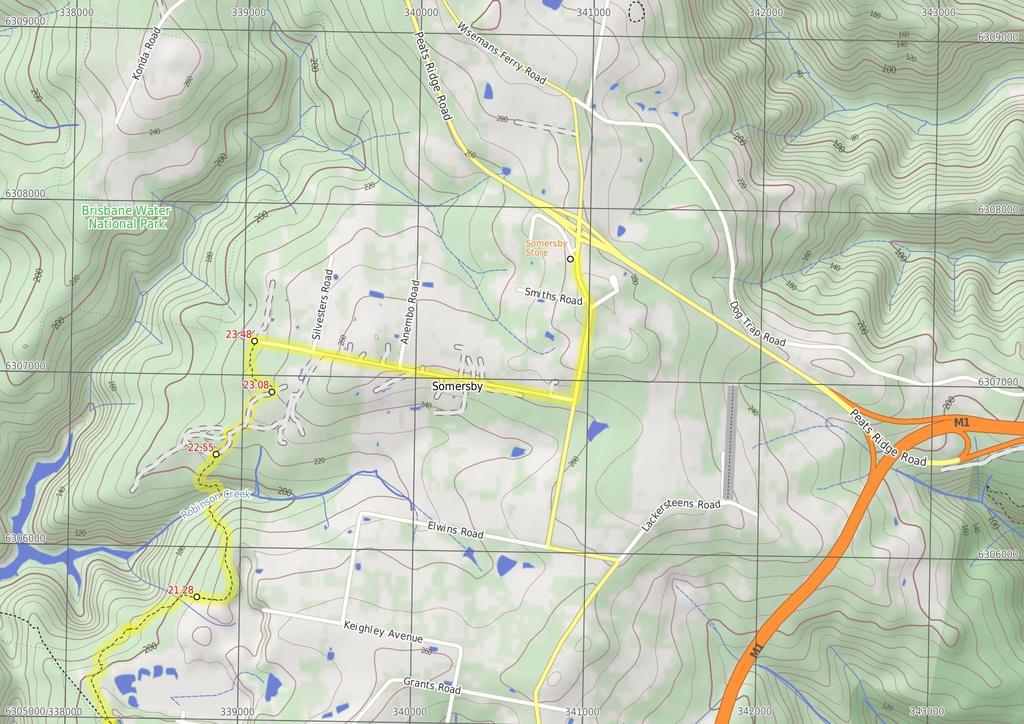
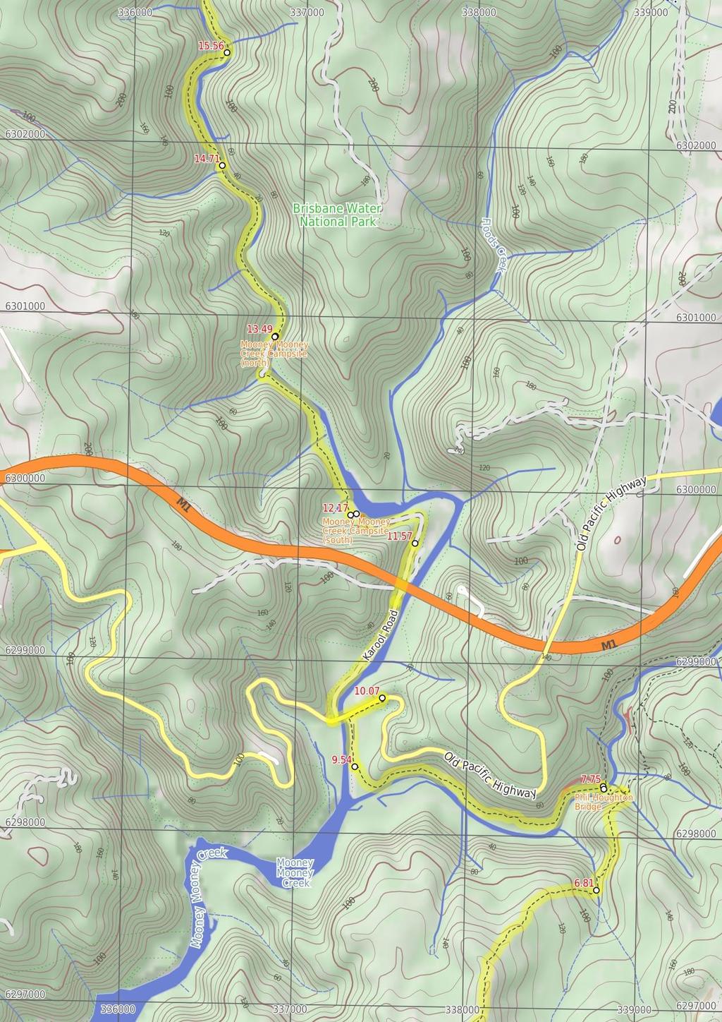
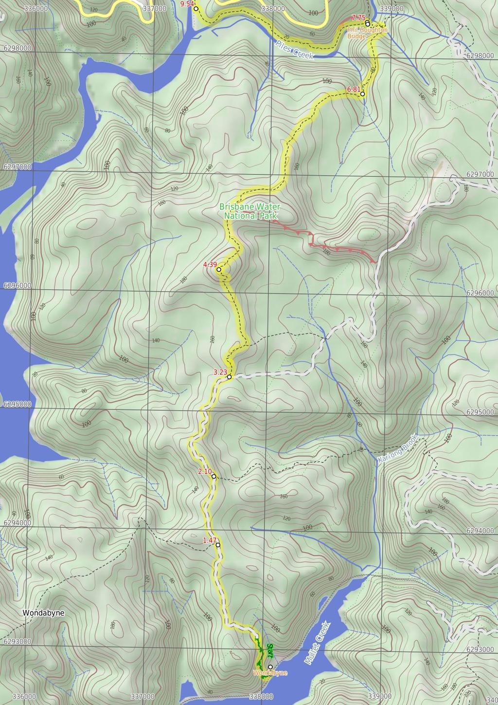
3 Are you ready to have fun? Please ensure you and your group are well prepared and equipped for all possible hazards and delays. Check park closures, weather information and Fire Danger Rating before setting out. Optional side trips and alternate routes noted are not included in this walks overall grade, length or time estimate. Please allow extra time for resting and exploring areas of interest. The authors, staff and owners of wildwalks take care in preparing this information but will not accept responsibility for any inconvenience, loss or injury you may experience. Please take care, have fun - Happy Walking. Getting there Traveling by train is the only practical way to get to Wondabyne Station (gps: , ). You can get back from Somersby Store (gps: , ) by car or bus. Bus: A bus service runs along Wisemans Ferry Rd passing Somersby store. The service runs between Gosford and Spencer only a few times a day. Please check timetable for more info or Phone Busway on (02) The bus only picks passengers up to head to Somersby on the afternoon runs. Car: There is free parking available. Find up to date and more information inlcuding; travel directions, weather, park closures and walker feedback at 0 Wondabyne Wondabyne is situated in Brisbane Waters National Park on the banks of Mullet River, which feeds into the Hawkesbury River north of Brooklyn. The area is defined by the National Park's flora and fauna, the quarry, railway station and a few houses sitting above the water around the river. The quarry produced sandstone building materials, used in the construction of the National War Memorial in Canberra. More recently, in 2000, the quarry was re-opened for restoration of St Mary's Cathedral spire in Sydney. Wondabyne Station, named after the nearby Mt Wondabyne, was built in 1889 and exclusively used for the quarry - it was then known as Mullet Creek Station. The station is one of the smallest on the line and one of very few railway stations in a NSW National Park. When you catch the train to Wondabyne, let the guard know you want to get off at Wondabyne Station, otherwise the train will not stop. Travel in the last carriage as the platform is very short. To catch the train from Wondabyne, wave to the driver. 0 Wondabyne Station (1.5 km 32 mins) From the north-bound platform of Wondabyne Station, this walk follows the 'The Great North Walk' sign off the southern the end of the platform, keeping the train lines (and water) to your left. The track soon leads past a strangler fig and a large boulder then bends right and heads up a timber staircase with a metal landing at the top. The track winds steeply uphill, up a series of timber and rock steps for just over 200m to pass a filtered view of the cranes (right), down at the old Gosford Quarry. Here the walk continues a bit more steeply uphill for another 150m, up a series of rock steps, and then, soon after passing up the carved steps in a cleft in a rock, the track flattens out and comes to a clearing at the end of a management trail, marked with a 'Brisbane Water National Park' sign. Continue straight: From the clearing, this walk follows the wide management trail uphill past the 'Brisbane Water National Park' sign. The trail leads up quite steeply for about 250m, where the trail bends right then leads gently uphill for about 600m. Here the trail leads up a short but quite steep hill, to then bend left and, about 150m later, come to an intersection with the Pindar Cave track (that leads over a rock platform, on your left), marked with a GNW arrow post (on your right) Eastern end of the Pindar Cave Track (630 m 11 mins) Continue straight: From the intersection, this walk follows the GNW arrow post north, gently uphill along the wide trail. The trail gently undulates along the top of the ridge for about 600m to come to an intersection with the 'Great North Walk' track (on your right), marked with a 'Wondabyne Station' sign pointing back down the hill. 2.1 Int of GNW and Wondabyne trail (1.1 km 22 mins) Continue straight: From the intersection, this walk follows the 'Girrakool' sign uphill along the wide trail. After about 50m, this trail leads up onto a large rock platform. From the top of this platform, there are some distant views over Mooney Mooney Creek. The walk continues on the platform, following the scrape marks on the rock, tending right, to soon find the wide trail again. The trail undulates (moderately steeply in a few places) along the ridge line for about 900m to come to an intersection marked with a 'Girrakool' sign (pointing left), just before a 'No Entry Past This Point' sign South end of Scopas Peak Track (1.2 km 23 mins) Turn left: From the intersection, this walk follows the 'Girrakool' sign and GNW arrow post north along the clear track. After about 150m, the walk comes to a green painted metal box on a post (on your right), containing a Great North Walk intentions book. Continue straight: From the Great North Walk intentions book, after leaving your comments, this walk heads north, gently up along the clear track. The track gently undulates along this ridge for about 750m, leading across a long sandy saddle to the base of Scopas Peak. Here the walk climbs steeply for about 230m, stopping occasionally to enjoy the view, up the series of rocks with cut steps and past a few rock walls. Near the top of this climb, the track bends left to lead up to a view point just to the west of Scopas Peak Scopas Peak (2.4 km 57 mins) Veer right: From the view point just west of Scopas Peak, this walk heads north-east and gently downhill, initially keeping the distant views to your left. The track leads down, becoming notably steeper for about 300m to then cross over a long rock platform, with a series of GNW arrow posts guiding the way. After this rock platform, the track leads for another 250m, crossing a couple of small rock platforms before leading along a heathy track. About 400m along, the walk passes another view to Mooney Mooney Bridge, then comes to the edge of another large rock platform. A series of GNW arrow posts lead across this rock platform, generally heading away from Scopas Peak for about 400m, where the arrows lead off the rock platform and back onto a heathy track. The rocky track continues down along the ridge for just shy of 300m to come to the edge of another smaller rock platform with more with distant views. From here, the track leads downhill for about 600m, passing a couple of rocky outcrops and becoming progressively steeper until coming to the edge of an intermittent creek, which flows over the solid sandstone platform, at the bottom of the valley Tributary Crossing (940 m 30 mins) Continue straight: From the western bank, this walk crosses the intermittent creek which flows over the solid sandstone platform, to follow the track uphill. The rocky track initially leads gently uphill but soon leads steeply up for about 130m, where the track mostly flattens out to pass a sandstone overhang (on your right). Soon after this overhang, the track leads over a small gully then along the side of a longer rock wall with another tall sandstone overhang. The track continues gently downhill for another 300m, becoming a little steeper along the way, until just past a set of rock steps. Here the track begins to head steeply down the side of the hill for about 130m, first passing through a cleft in the rock then past a few rock walls. Just after a few switchbacks, this walk heads into a narrow gully, past a small 'Patonga' sign, then comes to a three-way intersection beside an intermittent creek, marked with a large 'The Great North Walk' sign with a 'Patonga Ferry' arrow pointing back up the hill. Continue straight: From the intersection, this walk follows the 'Piles Creek' sign down the track (keeping the valley to the right). The rocky track heads steeply downhill for about 170m to Piles Creek. Just past the old bridge, this walk climbs up the stairs to cross the Phil Houghton suspension footbridge, enjoying the views of the tidal Piles Creek. On the other side, this walk climbs down the stairs to an intersection beside a large clearing (and campsite, on your left) Phil Houghton Bridge The Phil Houghton Bridge is a metal suspension bridge that crosses Piles Creek. It is part of the Great North Walk and replaces an older bridge, with part still visible upstream. The bridge can hold up to 8 people and feels very stable. There are great views both up and downstream half way across this bridge. There is a clearing on the northern side that people have used for camping Phil Houghton Bridge (1.8 km 36 mins) Turn left: From the intersection on the northern end of the 'Phil Houghton Bridge', this walk follows the 'Mooney Creek' arrow through the large clearing and campsite, keeping Piles Creek to your left. The track leads under a large dead tree then winds past some cliffs and among large boulders for about 1km then crosses a short timber bridge with handrails. Just past this bridge, this walk heads over a short flat timber bridge, then about just shy of 150m later, heads along a section of timber boardwalk. From this tall eucalypt forest, this track contours around the side of the hill for about 500m, alongside Piles Creek, then starts to climb passing among the grass trees before heading down a handful of timber steps and coming to a threeway intersection marked with a 'Brisbane Waters National Park' sign, just before Mooney Mooney Creek Brisbane Water NP sign (540 m 11 mins) Turn right: From the intersection, this walk follows the GNW arrow post directly away from the face of the 'Brisbane Waters National Park' sign along the clear track, keeping Mooney Mooney Creek to your left. After about 100m, this walk crosses a green timber footbridge, then about 200m later comes to a small clearing and intersection just before the road bridge. Here the walk turns right, following the old management trail uphill through the tall forest for about 200m then heading around a locked gate. Just past the gate, this walk turn left and heads up the short steep bank to come to a T-intersection with the old Pacific Hwy, at a large gravel car park marked with 'Mooney Mooney Creek' Trackhead (just east of the Mooney Mooney Creek bridge) Mooney Mooney Creek Trackhead (1.5 km 27 mins) Turn left: From the intersection, this walk follows the 'Newcastle' sign along the narrowing gravel verge, keeping the Old Pacific Hwy just to your right. After about 200m, this walk comes to then crosses the concrete road bridge over Mooney Mooney Creek, enjoying the view of the wide creek below. Once on the other side, this walk heads past a detailed 'Risk Warning' sign suggesting you be sensible as you cross the bridge (hope it is not too late) to then come to an intersection with Karool Rd, just on the other side of the highway (on your right). Turn right: From the intersection, this walk follows the gravel 'Karool Road' gently downhill, keeping Mooney Mooney Creek to your right. This road leads past a few homes for about 600m to then pass a notable houseboat house. About 250m past this house, this walk come to a Y-intersection, marked with a 'The Great North Walk' sign, just before the tall concrete Mooney Mooney Bridge. Veer left: From the 'Y' intersection, this walk follows the 'The Great North Walk' sign along the upper dirt road to pass under the Mooney Mooney (F3 freeway) Bridge. Just over 250m after passing under the tall bridge, this walk leads up to a large turning area just before the locked gate, marked with a 'Brisbane Water National Park' sign.
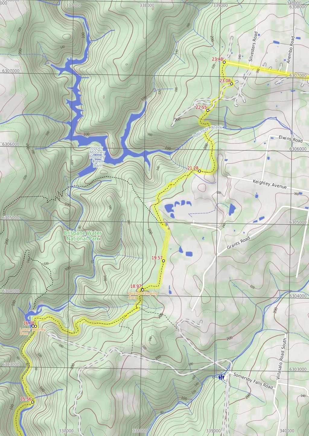
4 11.57 National Park Gate (600 m 13 mins) Continue straight: From the end of the dirt road (that branches of Karool Rd, just north of the Mooney Mooney Bridge), this walk heads uphill along the trail and around the locked gate next to the timber 'Brisbane Water National Park' sign. The trail leads uphill for about 200m to where the trail bends left to pass over the crest of the hill (passing a faint track on your left). Here the trail leads down the other side, still keeping Mooney Mooney Creek to your right for another 400m to come to an intersection marked with a GNW arrow post, beside a large grassy clearing and campsite (on your right) Mooney Mooney Creek crossing (1.2 km 28 mins) Continue straight: From the bank of Mooney Mooney Creek, this walk crosses the wide rock platform and creek to find the track again on the other side. This creek may become impassable after heavy or prolonged rain. Here the walk turns left and follows the rocky track that leads gently up alongside the creek through the pleasant forest. After a little over 1km, the walk comes into view of the tailwater of the dam and then past a fenced cutting (on your right), the site of an old pump house. About 60m past this fenced area, the walk leads up along the now widening track to find the edge of the fenced lower Mooney Mooney Dam wall Mooney Mooney Creek Campsite (south) This is clearing is beside the wide Mooney Mooney Creek and provides a large flat area to pitch a few tents. There are some high tension power lines nearby and you can hear the hum of the F3 from here, so it is not the most remote campsite. There are no facilities or water (the creek is salty). All that said it is still a pleasant spot beside the wide creek to rest for a while or for the night Lower Mooney Dam Lower Mooney Dam is located on the Mooney Mooney Creek, about 21 km upstream from the Hawkesbury River. In March 1938 the Gosford Mayor turned the tap to add the water from this dam into the small town water supply of the time. It is a concrete arch dam, with a capacity of 1,000 megalitres, and was superseded by the more than 4 times larger 'Upper Mooney Dam' in There is a set of timber steps and a faint track that leads down to the waters edge on the uphill side of the dam wall, the dam wall is fenced and is clearly out of bounds. A sign reminds visitors that swimming is not allowed Mooney Mooney Creek Campsite (south) (1.3 km 24 mins) Veer right: From the intersection just above the campsite, this walk follows the GNW arrow post down along the track, keeping the clearing and campsite to the right. The track soon leads over a small flat timber bridge then over the next 60m, the track heads under the high tension power lines (past the caution sign) and then along a short section of timber boardwalk. About 20m later, this walk veers right at a Y-intersection, then continues along the mostly flat track beside Mooney Mooney Creek for about 300m, to cross a small rocky tidal creek. The track then continues through the tall forest beside Mooney Mooney Creek for about 600m, passing a couple of she-oak stands before the track then bends left and comes to an indistinct intersection beside a timber and metal footbridge. Continue straight: From the intersection, this walk cross the timber and metal footbridge over a tidal, unnamed creek to then turn right and follow the track which soon bends left. Keeping Mooney Mooney Creek to the right, this track passes a small cliff then follows the mostly flat track through the tall forest for about 170m to come to a large clearing with tall blue gums and a metal fireplace (on your left), signposted as a 'Camping area' Mooney Mooney Creek Campsite (north) This signposted campsite is sits among the tall eucalypt and bracken fern forest beside the Mooney Mooney Creek. This is a very pleasant flat clearing to spend a night, there is a small metal fireplace hotplate and room for a small number of tents. There is No drinking water or other facilities at this campsite (Mooney Mooney Creek is salty at this point, treatable water may be found about 2km north) Mooney Mooney Creek Campsite (north) (1.2 km 22 mins) Continue straight: From the campsite, this walk follows the clear track north, keeping the wide Mooney Mooney Creek to your right. The clear, wide and mostly flat track leads alongside the creek for about 1.2km to come to the southern bank of Ausburn Creek (about 130m past a rock wall, on your left), a few metres above its confluence with Mooney Mooney Creek Ausburn Creek crossing (860 m 22 mins) Continue straight: From the south bank of Ausburn Creek, this walk crosses the narrow rock platform and creek, then follows the track fairly steeply uphill for about 200m. At the top of this climb, the track gently undulates alongside Mooney Mooney Creek for about 700m before heading down to find a large rock platform on the western bank of Mooney Mooney Creek. This large rock platform is a natural ford of the perennial Mooney Mooney Creek and is home to a scattering of small and large waterholes Lower Mooney Mooney Dam (2.2 km 53 mins) Continue straight: From the lower Mooney Mooney Dam, this walk heads uphill along the old trail, initially keeping the water on your left. The trail leads up, enjoying the occasional glimpse of water (on your left) for about 400m to pass a washed-out section of the old trail. From here, the walk continues up along the trail for about 1.3km, getting steeper as it climbs, and comes to a three-way intersection marked with a 'Mooney Creek' sign pointing back downhill. Turn left: From the intersection, this walk follows the 'Reserve Road' sign uphill along the old trail, initially keeping the valley to your left. After about 180m, this walk comes to a faint intersection marked with a 'The Great North Walk' sign. Turn left: From the intersection, this walk follows the 'The Great North Walk' sign downhill along the track for about 50m, to crosses a small pleasant gully with an ephemeral creek. After this, the track starts to wind moderately steeply uphill then, soon after flatting out, it comes to a signposted 'Camping Area' with a metal fireplace Quarry Camping Area This is a small signposted campsite set among heath, grass tress, scribbly gums and aother eucalpyts. The clearing is flat and sandy and provides room to set up a few tents with and a small metal fireplace with hotplate. There is no water or other facilites here Quarry Camping Area (590 m 11 mins) Continue straight: From in front of the 'camping area', this walk heads gently uphill along the sandy track, initially keeping the camping area to your right. After about 220m of walking through this scribbly gum forest and passing a small informal campsite on the way, this walk comes to the quarry boundary fence and turns left. Following the fence for about 70m, the track leads to a section of timber boardwalk with a view (right) over parts of the quarry. The walk continues along the fence for just over 250m, crossing a small flat timber bridge to come an intersection with a dirt road (just past the locked gate) Quarry gate (1.7 km 34 mins) Veer left: From the intersection, this walk follows GNW arrow marker gently downhill along the dirt road. This walk follows the road for about 400m to come to a large clearing with two large water reservoirs tanks. This walk continues past the two reservoirs (and past the treatment plant building, on your left) to come to a 'The Great North Walk' sign just in front of a small brick building. Continue straight: From the brick building, this walk follows the 'The Great North Walk' sign gently downhill along the gravel trail (away from the water tanks) for a few metres before turning right onto a track, following a GNW arrow post. This track leads through the banksia and she-oak forest for just over 100m to pass a 'The Great North Walk' sign and then cross Reservoir Rd. On the other side of the road, this track continues gently down through the sheoak (Casuarina glauca) forest for about 150m before crossing a metal footbridge. On the other side of the bridge, this walk turns left and follows the track as it winds down through the heathy bushland, alive with wildflowers in spring, for about 400m and crosses a small ephemeral creek. The track then leads under a set of high tension power lines and then bends right and leads gently up for another 20m, coming to an intersection with a power line management trail. Veer right: From the intersection, this walk follows the management trail uphill, keeping the power lines just to your right. After about 40m, this walk follows the GNW arrow post left (ignoring the 'Private Property' trail ahead) as the track winds gently uphill for about 250m before veering left, ignoring another 'Private Property' track (on your right). The mostly flat track now leads along the side of the hill for about 100m before passing under another set of power lines and leading right, steeply up the short rocky hill. At the top of this hill, the track leads to the end of a trail, but immediately veers right to follow a track along a fence for about 60m before rejoining the same power line management trail South end of Robinson Crk Track (1.3 km 31 mins) Veer right: From the intersection, this walk follows the GNW arrow post uphill along the wide management trail, following the power lines for about 100m before veering left to follow another GNW arrow post along a narrow track. The track leads into the bush among gymea lilies (Doryanthes excelsa) and eucalypts for almost 300m, crossing a couple of short flat timber bridges to then head along a few sections of timber board walk through a weedy section of bush. The track then continues gently downhill for another 150m to cross over a trail. Following the GNW arrow post, this track now begins to lead more steeply down for about 250m, passing through another large grove of gymea lilies, a small cave (on your left). The walk continues down the timber then stone steps to head into the dense moist forest and across a flat timber bridge, coming into view of the creek. Here the walk bends right and leads beside the creek for a short time before bending left, following the GNW arrow post across the creek flowing over the mossy rock bed. Just downstream is a small pool and cascade. Here the walk starts to climb up the other side of the valley, soon crossing a small flat timber bridge. The track then winds steeply out of the ferny and densely forested valley, up a series of timber and stone steps for about 130m where another GNW arrow post marks the end of this section of steep climbing. This track now leads gently up among some tall eucalypts and past a large grove of gymea lily for about 230m to come to a T-intersection with a wide management trail North end of Robinson Crk Track (540 m 10 mins) Veer right: From the intersection, this walk follows the GNW arrow post uphill along the wide sandy trail for about 40m to pass a faint trail (on your right). Then about 120m further up the main trail, this walk comes a T-intersection marked with a couple more GNW arrow posts. Turn right: From the intersection, this walk follows the GNW arrow post gently uphill along the sandy trail. The trail soon leaves the wooded forest and after about 120m, this walk veers left at an intersection in a clearing. After another 120m, the walk heads past a large grassy clearing (on your right) with some tall pine trees. The sandy trail continues for another 150m,
 Veer left: From the intersection, this walk follows the 'The Great North Walk' sign along the track, initially keeping the sandy trail to the right")
5 past a few scribbly gums, and comes to a Y-intersection marked with a 'The Great North Walk' sign (pointing left) Int of GNW and Private Property (400 m 7 mins) Veer left: From the intersection, this walk follows the 'The Great North Walk' sign along the track, initially keeping the sandy trail to the right for a short distance. The track soon bends left, then winds over a small rise through the scribbly gum forest for about 400m before heading over a short section of green boardwalk. A short distance later, this walk crosses a green timber footbridge and comes to an intersection at the end of the dirt Robinson Road End of Robinson Road (2.7 km 50 mins) Turn right: From the intersection, this walk follows the GNW arrow post uphill along the gravel Robinson Rd for about 300m to then continue straight ahead along the sealed Silvester Rd. This walk heads along the sealed road for another 500m to pass an intersection with 'Anembo Rd', then continues along Silvester Rd. Over the next 1km or so, the walk travels among the rural properties, passing some distant views of the peaks in Brisbane Water NP (to your right), before turning left onto Wisemans Ferry Road at the T-intersection. From this intersection, this walk leads up along the narrow grassy verge beside the road for about 500m to pass the large communications tower (on your right), heads over the crest of the hill then down for about 250m to come to Somersby Store (on your left) Somersby Store Somersby Store offers a good place to have lunch or pick up the basic food supplies. The store serves hot food including burgers, chips, pies etc and cold drinks. Opening hours are 6am - 6pm Monday to Friday and 6.30am to 4pm on Saturdays (closed Sundays). There is a pay phone and a bus stop however services are limited to two buses a day. Contact details are (02) , at 841 Wisemans Ferry Road Somersby, NSW The store owners are happy for you to phone ahead. If you are a large group you can order ahead to save the stress. I always encourage people to use local stores like this on track, but since it is a small store it is worth phoning ahead to see what they have what you want in stock.
6
7
8
9
10 Summary navigation sheet for the Wondabyne station to Somersby Store km From Start Wondabyne Station , (GR Gosford, ) 1.47 Eastern end of the Pindar Cave Track , (GR Gosford, ) 2.10 Int of GNW and Wondabyne trail , (GR Gosford, ) 3.23 South end of Scopas Peak Track , (GR Gosford, ) 4.39 Scopas Peak , (GR Gosford, ) 6.81 Tributary Crossing , (GR Gosford, ) 7.75 Phil Houghton Bridge , (GR Gosford, ) 9.54 Brisbane Water NP sign , (GR Gosford, ) Mooney Mooney Creek Trackhead , (GR Gosford, ) National Park Gate , (GR Gosford, ) Mooney Mooney Creek Campsite (south) , (GR Gunderman, ) Mooney Mooney Creek Campsite (north) , (GR Gunderman, ) Ausburn Creek crossing , (GR Gunderman, ) Mooney Mooney Creek crossing , (GR Gunderman, ) Lower Mooney Mooney Dam , (GR Gunderman, ) Quarry Camping Area , (GR Gosford, ) Quarry gate , (GR Gosford, ) South end of Robinson Crk Track , (GR Gosford, ) North end of Robinson Crk Track , (GR Wyong, ) Up/Dwn Length Initial directions (Use full tracknotes and maps for more detail) km 32 mins 630 m 11 mins 1.1 km 22 mins 1.2 km 23 mins 2.4 km 57 mins 940 m 30 mins 1.8 km 36 mins 540 m 11 mins 1.5 km 27 mins 600 m 13 mins 1.3 km 24 mins 1.2 km 22 mins 860 m 22 mins 1.2 km 28 mins 2.2 km 53 mins 590 m 11 mins 1.7 km 34 mins 1.3 km 31 mins From the north-bound platform of Wondabyne Station, this walk follows the 'The Great North Walk' sign off the southern the end of the platform, keeping the train lines (and water) to your left. Continue straight: From the intersection, this walk follows the GNW arrow post north, gently uphill along the wide trail. Continue straight: From the intersection, this walk follows the 'Girrakool' sign uphill along the wide trail m 10 mins Veer right: From the intersection, this walk follows the GNW arrow post uphill along the wide sandy trail for about 40m to pass a faint trail (on your right). Turn left: From the intersection, this walk follows the 'Girrakool' sign and GNW arrow post north along the clear track. Veer right: From the view point just west of Scopas Peak, this walk heads north-east and gently downhill, initially keeping the distant views to your left. Continue straight: From the western bank, this walk crosses the intermittent creek which flows over the solid sandstone platform, to follow the track uphill. Turn left: From the intersection on the northern end of the 'Phil Houghton Bridge', this walk follows the 'Mooney Creek' arrow through the large clearing and campsite, keeping Piles Creek to your left. Turn right: From the intersection, this walk follows the GNW arrow post directly away from the face of the 'Brisbane Waters National Park' sign along the clear track, keeping Mooney Mooney Creek to your left. Turn left: From the intersection, this walk follows the 'Newcastle' sign along the narrowing gravel verge, keeping the Old Pacific Hwy just to your right. Continue straight: From the end of the dirt road (that branches of Karool Rd, just north of the Mooney Mooney Bridge), this walk heads uphill along the trail and around the locked gate next to the timber 'Brisbane W... Veer right: From the intersection just above the campsite, this walk follows the GNW arrow post down along the track, keeping the clearing and campsite to the right. Continue straight: From the campsite, this walk follows the clear track north, keeping the wide Mooney Mooney Creek to your right. Continue straight: From the south bank of Ausburn Creek, this walk crosses the narrow rock platform and creek, then follows the track fairly steeply uphill for about 200m. Continue straight: From the bank of Mooney Mooney Creek, this walk crosses the wide rock platform and creek to find the track again on the other side. Continue straight: From the lower Mooney Mooney Dam, this walk heads uphill along the old trail, initially keeping the water on your left. Continue straight: From in front of the 'camping area', this walk heads gently uphill along the sandy track, initially keeping the camping area to your right. Veer left: From the intersection, this walk follows GNW arrow marker gently downhill along the dirt road. Veer right: From the intersection, this walk follows the GNW arrow post uphill along the wide management trail, following the power lines for about 100m before veering left to follow another GNW arrow post along a n...
11 Summary navigation sheet for the Wondabyne station to Somersby Store km From Int of Great North Walk and Private Property , (GR Wyong, ) End of Robinson Road , (GR Wyong, ) Powered by TCPDF ( Up/Dwn Length Initial directions (Use full tracknotes and maps for more detail) m 7 mins 2.7 km 50 mins Veer left: From the intersection, this walk follows the 'The Great North Walk' sign along the track, initially keeping the sandy trail to the right for a short distance. Turn right: From the intersection, this walk follows the GNW arrow post uphill along the gravel Robinson Rd for about 300m to then continue straight ahead along the sealed Silvester Rd.
Girrakool to Wondabyne station
 Girrakool to Wondabyne station 4 hrs Hard track 9.5 km One way 4 438m This walk starts from the Girrakool picnic area and winds south, through the Brisbane Waters National Park. The walk crosses some long
Girrakool to Wondabyne station via Pindar caves
 Girrakool to Wondabyne station via Pindar caves 7 hrs 30 mins 18.1 km One way Experienced only 5 741m This walk starts from the Girrakool picnic area and winds south, following Piles creek into the Brisbane
Staples Lookout to Mt Wondabyne loop
 Staples Lookout to Mt Wondabyne loop 4 hrs 3 mins 1.8 km Circuit Hard track 337m This walk starts and finishes at Staples Lookout, on Woy Woy Rd. The walk follows sections of the Great North Walk around
Mt Kuring-gai Track to Berowra station
 Mt Kuring-gai Track to Berowra station 4 hrs 15 mins 9.7 km One way Hard track 4 553m This walk explores three valleys, with great displays of wild flowers in spring, and some nice sandstone overhangs.
Berowra Waters to Cowan Station
 Berowra Waters to Cowan Station 3 hrs 30 mins 7.2 km One way Hard track 597m This is a hilly walk out of the beautiful Berowra Waters valley to Cowan Station. There are many wide views across Berowra Creek
Congewai Track Head (East) to Watagan Headquarters
 to Watagan Headquarters") Congewai Track Head (East) to Watagan Headquarters 7 hrs Hard track 17.2 km One way 4 973m This full day walk starts from the Congewai valley trackhead (east) and follows the Great North Walk up into the
Congewai Track Head (East) to Watagan Headquarters 7 hrs Hard track 17.2 km One way 4 973m This full day walk starts from the Congewai valley trackhead (east) and follows the Great North Walk up into the
Somersby to Yarramalong via Stringy Bark Point
 Somersby to Yarramalong via Stringy Bark Point 2 Days Hard track 26.7 km One way 4 1201m This section of the Great North Walk starts form the Somersby General Store and follows the Great North Walk north
Erskine Creek via Pisgah Rock and Jack Evans
 Erskine Creek via Pisgah Rock and Jack Evans 4 hrs 30 mins 7.1 km Circuit Very experienced only 6 421m This walk visits some great lookouts and explores the lower section of Erskine Creek. Most of the
Abbotts Falls Walking Track
 Abbotts Falls Walking Track 3 hrs 7.3 km Circuit Hard track 329m This circuit takes you through both dry and moist forest, using a combination of walking trails and wider tracks. The side trip to the dammed
Patonga to Wondabyne station via Mt Wondabyne
 Patonga to Wondabyne station via Mt Wondabyne 7 hrs 3 mins 19.5 km One way Hard track 4 861m This walk explores some grand views, pleasant cascades, varied bushland and remote areas of Brisbane Waters
Merritts Traverse. 1928m
 Merritts Traverse 3 hrs Hard track 5.8 km Circuit 4 167m This walk starts with a scenic journey to the top of the hill on the chairlift. Starting along Merritts Nature walk, this walk soon detours down
Nature Track. 900m. 789m. 2 hrs 3.1 km Circuit. Hard track 238m. Blue Mountains National Park
 Nature Track 2 hrs 3.1 km Circuit Hard track 238m Largely following the ridges around the top edge of Wentworth Falls, this track is incredibly beautiful. After taking in the great views at Edinburgh Castle
Victoria Falls Lookout to Blue Gum Forest
 Victoria Falls Lookout to Blue Gum Forest 8 hrs Experienced only 13.8 km One way 5 112m This long day-walk follows a remote track down from Victoria Falls lookout, passing the waterfall, and into the Grose
Leura Cascades to Gordon Falls Reserve
 Leura Cascades to Gordon Falls Reserve 1 hr 15 mins 1.8 km One way Moderate track 200m From Leura Park to Gordon Falls Park, this diverse walk offers fantastic views of the Jamison Valley, as well as two
Patonga to Staples Lookout
 Patonga to Staples Lookout 6 hrs 3 mins 17 km One way Hard track 4 72m This great walk explores much of the main ridge ridge running through Brisbane Water National Park. The walk visits a number of great
Somersby to the Basin Campsite
 Somersby to the Basin Campsite 3 Days Hard track 47.4 km One way 4 2032m This three day walk starts at the Somersby General Store and follows the Great North Walk, heading north, into the the Jilliby State
Berowra to Cowan via Berowra Waters
 Berowra to Cowan via Berowra Waters 6 hrs Hard track 12.9 km One way 4 884m With train station at each end this walk explores the ridges and valleys around Berowra Waters. There are plenty of excellent
Guthega to Mt Twynam. 2183m. 1583m. 6 hrs 45 mins 14.8 km Return. Experienced only. 913m
 Guthega to Mt Twynam 6 hrs 45 mins 14.8 km Return Experienced only 5 913m This walk starts from Guthega and makes its way along the Snowy River to the Illawong Lodge, via the Blue Cow Creek flying fox.
Crosslands to Cowan. 220m
 Crosslands to Cowan 7 hrs 30 mins 14 km One way Hard track 4 1103m This section of the Great North Walk starts from the Crosslands camping area and winds north alongside Berowra creek, passing through
Patonga to Wondabyne station via Pindar Caves overnight
 Patonga to Wondabyne station via Pindar Caves overnight 2 Days Experienced only 28.1 km One way 5 1164m This overnight hike starts from Patonga beach and winds along a section of the Great North Walk,
Crosslands to Berowra Waters return
 Crosslands to Berowra Waters return 6 hrs Hard track 13.7 km Return 4 1005m This return walk starts from the Crosslands Reserve and follows the Great North Walk along Berowra creek. The walk includes some
Dadder Cave and Jack Evans track
 Dadder Cave and Jack Evans track 2 Days 10.3 km Circuit Very experienced only 535m This fairly short overnight walk is a great way to explore Erskine Creek. The walking along Erskine creek is mostly off
Jerusalem Bay Track (Cowan to Brooklyn)
") Jerusalem Bay Track (Cowan to Brooklyn) 5 hrs 30 mins 13.4 km One way Hard track 4 654m This Cowan to Brooklyn Station walk is a popular section of the Great North Walk, with scenery ranging from foreshore
Jerusalem Bay Track (Cowan to Brooklyn) 5 hrs 30 mins 13.4 km One way Hard track 4 654m This Cowan to Brooklyn Station walk is a popular section of the Great North Walk, with scenery ranging from foreshore
Scenic Railway to Ruined Castle
 Scenic Railway to Ruined Castle 7 hrs 30 mins 12.4 km Return Hard track 4 963m This is a very popular, full day walk, in the Katoomba Area, offering great views of the valley. The walk follows the edge
Cowan to Wondabyne station via Patonga rest area
 Cowan to Wondabyne station via Patonga rest area 2 Days Hard track 33.4 km One way 4 1523m This section of the Great North Walk starts from Cowan train station and wanders past the majestic Jerusalem Bay
Gibberagong Track. 169m
 Gibberagong Track 2 hrs 30 mins 6.5 km One way Hard track 4 180m Starting in suburban Wahroonga, this wellmaintained track follows Cockle Creek down to Bobbin Head in the Ku-ring-gai Chase National Park.
Crosslands to Brooklyn
 Crosslands to Brooklyn 2 Days Hard track 27.4 km One way 4 1757m From the Crosslands Reserve, this walk heads along the Great North Walk via Berowra Waters, Cowan, Jerusalem Bay and onto Brooklyn. This
Wentworth Pass. 893m. 535m. 4 hrs. Hard track 5.1 km Circuit. 692m
 Wentworth Pass 4 hrs Hard track 5.1 km Circuit 4 692m This walk offers a great way to explore the magical, upper section of the Valley of the Waters. The walk starts and finishes at Conservation Hut, which
Hornsby station to Crosslands
 Hornsby station to Crosslands 6 hrs 45 mins 16.1 km One way Hard track 4 938m This section of the Great North Walk starts from Hornsby train station and winds down along the Blue Gum Walk into Fishponds.
Berowra to Hornsby. 9 hrs 18 mins 22.6 km One way. Hard track. 1423m
 Berowra to Hornsby 9 hrs 18 mins 22.6 km One way Hard track 4 1423m One of the longer day walks in Berowra Valley National Park, this walk mostly follows Berowra Creek along the Great North Walk. Excellent
National Pass. 893m. 665m. 3 hrs 30 mins 4.6 km Circuit. Hard track 773m. Blue Mountains National Park
 National Pass 3 hrs 3 mins 4.6 km Circuit Hard track 773m 4 This walk offers fantastic views of the Jamison Valley and the surrounding cliffs. Take time to explore the historic and very scenic ledge halfway
Victoria Falls to Blackheath Station
 Victoria Falls to Blackheath Station 2 Days Experienced only 22.2 km One way 5 1561m This is a fantastic overnight walk with a sleep in Acacia Flats camping area. The Grose Valley, with its views of the
Victoria Falls and Grose Valley to Blackheath Station
 Victoria Falls and Grose Valley to Blackheath Station 3 Days Experienced only 22.5 km One way 5 158m This walk explores a fantastic section of the Grose Valley. Starting above Victoria Falls, the walk
Main Range Walk - Charlotte Pass to Mount Kosciuszko
 Main Range Walk - Charlotte Pass to Mount Kosciuszko 9 hrs Hard track 21.9 km Circuit 4 920m This full day walk explores some of the greatest alpine country on offer in NSW. The walk grants views of Blue,
Main Range Track - Loop from Charlotte Pass camping near Mt Townsend
 Main Range Track - Loop from Charlotte Pass camping near Mt Townsend 2 Days Experienced only 27.7 km Circuit 5 1260m This great overnight walk starts from Charlotte Pass and provides access to some of
Lady Carrington Drive
 Lady Carrington Drive 3 hrs 45 mins 9.7 km One way Moderate track 3 266m This walk follows the historic Lady Carrington Drive alongside the Hacking River. The old road is closed to traffic and provides
Leura to Katoomba via Dardanelles Pass
 Leura to Katoomba via Dardanelles Pass 4 hrs 6.6 km One way Hard track 697m With approximately equal parts cliff-walk and forest track, this track truly shows what the cliff edges of the Jamison Valley
Blackheath to Blue Gum loop
 Blackheath to Blue Gum loop 2 Days Hard track 24.1 km Circuit 4 1335m This walk is great for fit people getting into overnight walking, with its fantastic scenery and nostalgia as a classic overnighter.
Guthega to Thredbo camping overnight at Wilkensons Creek
 Guthega to Thredbo camping overnight at Wilkensons Creek 2 Days Experienced only 25.8 km One way 5 1364m This great overnight walk explores the Kosciusko National Park between Guthega and Thredbo, visiting
Katoomba to Wentworth Falls via the Jamison Valley
 Katoomba to Wentworth Falls via the Jamison Valley 2 Days Experienced only 29.2 km One way 5 2135m This is the two day version of this popular and challenging walk. This walk passes popular sights including
The Prince Henry Cliff Walk
 The Prince Henry Cliff Walk 3 hrs 30 mins 6.8 km One way Moderate track 3 575m Going from Katoomba to Leura, this walk covers the top of the cliff line and most of the major lookouts. With brilliant vistas
Gordon to Hornsby (overnight at Scout camp)
") Gordon to Hornsby (overnight at Scout camp) 2 Days Hard track 25.8 km One way 4 125m This overnight walk starts from Gordon train station and winds through bush filled valleys to Hornsby station. From
Gordon to Hornsby (overnight at Scout camp) 2 Days Hard track 25.8 km One way 4 125m This overnight walk starts from Gordon train station and winds through bush filled valleys to Hornsby station. From
Thornleigh to Cowan. 2 Days. Hard track 35.9 km One way. 2337m
 Thornleigh to Cowan 2 Days Hard track 35.9 km One way 4 2337m Following the Great North Walk and Berowra Creek through Berowra Valley Regional Park, this walk cuts straight through the length of the Park.
COLOUR G U I D E. Sydney to Newcastle: Australia s most accessible long-distance walk
 COLOUR G U I D E Sydney to Newcastle: Australia s most accessible long-distance walk Woodslane Press Pty Ltd Unit 7/5 Vuko Place Warriewood, NSW 2102 Australia Email: info@woodslane.com.au Tel: (02)
Main Range Circuit from Guthega
 Main Range Circuit from Guthega 4 Days Experienced only 45 km Circuit 5 2317m This four day walk explores the Kosciuszko National Park, covering many of the key features of the park between Guthega and
Western Commission Track to Dubbo Gully
 This two day walk follows a series of historic roads along clear and wide management trails. This walk explores the great views from Western Commission Track, the sandstone handicraft on the Old Great
Victoria Falls and Grose Valley to Blackheath Station
 This walk explores a fantastic section of the Grose Valley. Starting above Victoria Falls, the walk explores the cascades before dropping into the valley for the first nights rest at Burra Korain campsite.
Printed in China by Designed by Coral Lee Main cover image: Broken Bay
 Woodslane Press Pty Ltd Unit 7/5 Vuko Place Warriewood, NSW 2102 Australia Email: info@woodslane.com.au Tel: (02) 9970 5111 Fax: (02) 9970 5002 http://travelandoutdoor.bookcentre.com.au First published
Out and about at Geehi
 Geehi Geehi Flats is a large area of flat floodplain on the banks of the Swampy Plains River. Located within Kosciuszko National Park, it is home to a popular campsite in summer for people wanting to enjoy
The Mendip Way. Route Directions and Maps Uphill to Wells
 The Mendip Way Route Directions and Maps Uphill to Wells Website: www.mendiphillsaonb.org.uk Email: mendip@mendiphillsaonb.org.uk Facebook & Twitter: @MendipHillsAONB Phone: 01761462338 1 Uphill to Loxton
Bewl Water & the High Weald
 1 Bewl Water & the High Weald Stonegate station - Stonegate - Wallcrouch - Newbarn - Cousley Wood - Wood's Green - Wadhurst station Length: 9 ½ miles (15.3km) Underfoot: Large portions of this path are
Telluride-to-Moab Alternative Singletrack Options
 Telluride-to-Moab Alternative Singletrack Options Day 1 Day 1 Alternate 1: Galloping Goose to Deep Creek. 18.4 miles, ascent 3,530ft, descent 1,388ft. This is fun, flowey, moderate to intermediate singletrack
Leaden Boot Challenge ROUTE INSTRUCTIONS
 Leaden Boot Challenge ROUTE INSTRUCTIONS Section 1 Alstonefield to Ilam From the village hall car park turn R then L and pass through the village keeping to the R to enter Church Street. Pass the Church
Trail Phasing Plan. Note: Trails in the Clear Creek Canyon area (Segments will be finalized in the future to minimize wildlife impacts
 Note: Trails in the Clear Creek Canyon area (Segments 2 5 and a future JCOS connection) will be finalized in the future to minimize wildlife impacts Trail Phasing Plan P Parking 3 Easy Trail Intermediate
beach. Make the ford and follow the trail out to the junction with Red Creek Tr in an open grassy area.
 Description: This is a moderate to slightly strenuous 22.8 mile backpack (add 2.6 miles if you do the packless out and back to the Lion s Head) that will have you exploring nearly every thing that is The
Leaden Boot Challenge 2016 ROUTE INSTRUCTIONS
 Leaden Boot Challenge 2016 ROUTE INSTRUCTIONS Section 1 Alstonefield to Ilam (CP2) From the village hall car park turn R then L and pass through the village keeping to the R to enter Church Street. Pass
East West route and Leatham Molesworth route (route guide) Molesworth Recreation Reserve
 Molesworth Recreation Reserve") East West route and Leatham Molesworth route (route guide) Molesworth Recreation Reserve 0BIntroduction The East West route links the Clarence (Kahutara River in Ka Whata Tu o Rakihouia) Conservation Park
East West route and Leatham Molesworth route (route guide) Molesworth Recreation Reserve 0BIntroduction The East West route links the Clarence (Kahutara River in Ka Whata Tu o Rakihouia) Conservation Park
Rogue Gorge (Mt. Stella) Roadless Area-- T30S R3E (primarily in portions of Sections 23, 26, 33, 34 & 35)
 Roadless Area-- T30S R3E (primarily in portions of Sections 23, 26, 33, 34 & 35)") Rogue Gorge (Mt. Stella) Roadless Area-- T30S R3E (primarily in portions of Sections 23, 26, 33, 34 & 35) Rogue River-Siskiyou National Forest--High Cascades Ranger District Upper, higher elevation trail
Rogue Gorge (Mt. Stella) Roadless Area-- T30S R3E (primarily in portions of Sections 23, 26, 33, 34 & 35) Rogue River-Siskiyou National Forest--High Cascades Ranger District Upper, higher elevation trail
Beautiful Walks from the Blue Ball Inn
 Walk No. 5 RIVER VALLEYS AND MOOR Countisbury, Watersmeet, Hillsford Bridge, Cheriton, Shilstone Hill, Rockford and Chiselcombe. 8.5 MILES APPROX. Walking time four and a half hours approx. OS 1;25,000
Hindhead, Keffolds Copse and Gibbet Hill
 point your feet on a new path, Keffolds Copse and Gibbet Hill Distance: 6 km=4 miles Region: Surrey Author: Schwebefuss Refreshments: Punch Bowl Café moderate walking Date written: 14-apr-2015 Last update:
Trail Beginning Elevation: 7553 ft The Poison Creek Trailhead is located at the end of National Forest Road 646E (NF-646E).
.") West Mountain Trails Poison Creek Trail #134 Length: 2.9 miles (4.7 km) Difficulty Horseback: A good trail for the first time west mountain rider, some steep sections Hiking: Most Difficult USGS Maps:
West Mountain Trails Poison Creek Trail #134 Length: 2.9 miles (4.7 km) Difficulty Horseback: A good trail for the first time west mountain rider, some steep sections Hiking: Most Difficult USGS Maps:
Self-Guided Walk Langdale Pikes. Start & Finish: NT car park (free to members) at Sticklebarn - on the right just beyond the New Dungeon Ghyll hotel.
 at Sticklebarn - on the right just beyond the New Dungeon Ghyll hotel.") Self-Guided Walk Langdale Pikes Key Information These mountains form a collection of spires and cliffs on the north side of Langdale. This walk visits four of the main tops Pavey Ark, Harrison Stickle,
Self-Guided Walk Langdale Pikes Key Information These mountains form a collection of spires and cliffs on the north side of Langdale. This walk visits four of the main tops Pavey Ark, Harrison Stickle,
IRON BARK and COLENSO HUTS 260 Series Map: 1:50, U21 NZ Grid GPS: Geodetic Datum 1949
 IRON BARK and COLENSO HUTS 260 Series Map: 1:50,000 260-U21 NZ Grid GPS: Geodetic Datum 1949 Topo50 Map: BK36 Taoroa Junction GPS: on WGS84 How to get to START: Exit Taupo on SH1 down the lake to Turangi
CWMGIEDD FROM ABERCRAVE
 Abercrave to Cwmgiedd Walk Page 1 Starting from The Abercrave Inn. Grid Ref: SN 824128 From the Abercrave Inn, an 11.3km (7 miles) walk to the foothills of the Cribarth Mountain, then through forest to
ROAD SCHOLAR SPRING HIKING ADVENTURE Tentative Schedule April 9-14, 2017
 ROAD SCHOLAR SPRING HIKING ADVENTURE Tentative Schedule April 9-14, 2017 Sunday, April 9 PM 3:00-5:00 Arrival, registration and move in to the dorm. 6:00 Supper EVE 7:15 Welcome & Orientation, Sign Ups
Slad over to Pitchcombe and back
 The walk climbs up from Slad over Wickridge Hill, descends to near Pitchcombe, then climbs back over Wickridge hill and round the back of Slad. Page 1 Start Point: SO 8718 0732 The Woolpack, Slad Length:
Lava Mountain Trail Distance: Elevation Range: Trail Type: Difficulty: Season: Driving Distance: Driving Time: USGS Maps: Pros Cons
 Lava Mountain Trail Distance: 13.4 miles (including the side trip to North Star Lake) Elevation Range: 5900'-8330' Trail Type: singletrack Difficulty: moderate Season: late June-October Driving Distance:
Lake Wissota Access Locations within the LaFayette Township. By Chad Martin
 Lake Wissota Access Locations within the LaFayette Township By Chad Martin Anson/ Wissota Access Point # 1 Road: 195 th St. Associated Fire Numbers: 13294 Defining Characteristics: Forested from road
Central Coast Hunter Range Region Discovery Program
 Central Coast Hunter Range Region Discovery Program Sydney to Newcastle General Inquiries NPWS (02) 4320 4200 (Monday - Friday) Detailed Information Anne Whyte, Discovery Coordinator NPWS (02) 4320 4205
GOLDEN EARS PROVINCIAL PARK
 GOLDEN EARS PROVINCIAL PARK Trail Information as of October 10 th 2015 Do not underestimate the mountainous wilderness of Golden Ears Provincial Park. The combination of rugged terrain and rapidly changing
County Line trail - Miller Peak to Little Navaho
 County Line trail - Miller Peak to Little Navaho 7-17-2008 This hike features a portion of the County Line trail in the Teanaway that receives extremely little use despite offering a spectacular ridge-run
Tiger Mountain State Forest:
 98 60 hikes within 60 miles: SEATTLE 20 Tiger Mountain State Forest: West Tiger Mountain Three Loop i KEY AT-A-GLANCE INFORMATION Length: 5.1 miles round-trip Configuration: Loop Difficulty: Moderate difficult
Route #2) Mt. Massive - Southwest Slopes
 Mt. Massive - Southwest Slopes") Route #2) Mt. Massive - Southwest Slopes Difficulty: Class 2 Ski: Advanced, D6 / R2 / III Exposure: Summit Elevation: Trailhead Elevation: Elevation Gain: Round-trip Length: Trailhead: County Sheriff:
Route #2) Mt. Massive - Southwest Slopes Difficulty: Class 2 Ski: Advanced, D6 / R2 / III Exposure: Summit Elevation: Trailhead Elevation: Elevation Gain: Round-trip Length: Trailhead: County Sheriff:
Photographing Upper Peninsula Waterfalls
 Photographing Upper Peninsula Waterfalls Tod Poirier Freelance Photographer Photography is one of my passions. The following spread showcases several Upper Peninsula waterfalls. At times a single drop
Difficult Run Stream Valley Park
 Difficult Run Stream Valley Park The more intense mountain bikers have known about for Difficult Run for some time. Equestrians have known it longer. Eight miles of unpaved trail, the Rails to River Trail
Camp Jack Wright PERMANENT ORIENTEERING COURSE (2004)
") Camp Jack Wright PERMANENT ORIENTEERING COURSE (2004) WHAT IS ORIENTEERING? The skill which enables a person to navigate with a map. In the competitive sport, the winner is the person who finishes in the
Camp Jack Wright PERMANENT ORIENTEERING COURSE (2004) WHAT IS ORIENTEERING? The skill which enables a person to navigate with a map. In the competitive sport, the winner is the person who finishes in the
San Miguel to Caserio de la Hoya Circular (San Miguel)
") Tenerife Sur: Short Walks Under 10 km San Miguel to Caserio de la Hoya Circular (San Miguel) Route Summary An informative and scenic walk back in time from San Miguel to below El Roque, overlooking the
Tenerife Sur: Short Walks Under 10 km San Miguel to Caserio de la Hoya Circular (San Miguel) Route Summary An informative and scenic walk back in time from San Miguel to below El Roque, overlooking the
ID: 283 Distance: 6.2 miles Height gain: 500 Metres Map: Explore OL 19 Contributor David and Chris Stewart
 Walkingworld Wild Boar Fell ID: 283 Distance: 6.2 miles Height gain: 500 Metres Map: Explore OL 19 Contributor David and Chris Stewart Features Birds, Great Views, Hills or Fells Description: Wild Boar
Black Hill Regional Park, Little Seneca Lake
 Black Hill Regional Park, ittle Seneca ake ittle Seneca ake, in Black Hill Regional Park, is a reservoir created after a previous drought struck the Washington area. The park is under Maryland-National
Sponsored by. statestreet.com
 /STATESTREETISLANDWALK #ISLANDWALKJSY Sponsored by statestreet.com Important Information If you forget everything else PLEASE remember the following.» Remember to check OUT of every checkpoint» If you
Marilla Reservoir to Chestnut Ridge via Marilla Trails and Bullis Hollow Trail east to west
 USGS topographic maps useful to this hike are the Bradford and Stickney 7.5 minute sectionals. These notes are designed to assist in identifying distance and location using geophysical and man-made characteristics
Walking Track Classification System Parks and Wildlife Service
 Appendix A Walking Track Classification Specifications Walking Track Classification System Parks and Wildlife Service This Walking Track Classification System is the outcome of a review of the track classifications
Hiking Trail Descriptions
 Hiking Trail Descriptions For ye shall go out with joy. And be led forth with peace. The mountains and the hills shall break forth before you in singing. And all the trees of the fields shall clap their
Kakadu Highlights No. 9: September 23 - October 6, 2018
 Kakadu Highlights No. 9: September 23 - October 6, 2018 Section 1: Barramundi Creek: September 23-26 We begin with a four to six hour, 350 kilometre drive from Darwin. The last 45 kilometres is on a 4WD
London to Oxford Trek map
 London to Oxford Trek map Route stats: 103.6 km (64.4 miles) with 800 metres of climbing Start time: 08:00-09:00am Checkpoints: Start - Spelthorne Leisure Centre TW18 1AJ Distance: 0km (0m) Leave here
Tumbler Ridge Global Geopark
 Tumbler Ridge Global Geopark WILDERNESS WATERFALLS These waterfalls are in remote locations, no trails exist, and GPS is required. Not every geosite needs a hiking trail. Providing ready access to all
Illawarra Escarpment State Conservation Area Walking Tracks
 Illawarra Escarpment State Conservation Area Walking Tracks NPWS Illawarra Area Office Ground Floor, Government Office Block 84 Crown Street Wollongong NSW 2500 02 4223 3000 (Mon-Fri) Royal National Park
Hadleigh Castle and Chalkwell Oaze
 1 Hadleigh Castle and Chalkwell Oaze Benfleet station Hadleigh Park Hadleigh Castle Leigh-on-Sea Chalkwell station A short stroll through the lush woods of Hadleigh Park high above the Thames-side marshes,
Staunton River Trail to Hoover Camp and Fork Mtn. Relay Tower (Based on September 18, 2013 hike by Ron Singleton, Fredericksburg, Va.
 Staunton River Trail to Hoover Camp and Fork Mtn. Relay Tower (Based on September 18, 2013 hike by Ron Singleton, Fredericksburg, Va.) The President's Cabin (The "Brown" House) at Camp Hoover. Sign on
Ystwyth and Rheidol Bridleway Routes. Route 2:Llanilar Circular
 Ystwyth and Rheidol Bridleway Routes Route 2:Llanilar Circular Route overview and terrain: A long circle using connecting ridges with fine views to link the Rheidol and Ystwyth river valleys. The route
BRR Leg 1 (3.9 miles, Easy)
") BRR Leg 1 (3.9 miles, Easy) Min 3901 Max 4919 Ascent +21 Descent -1031 0.0 Start (Grayson Highlands State Park Visitor Center) 3.9 Grayson Highlands State Park Office & Gate, on R (EZ 1) Leg Notes: Minimal
BRR Leg 1 (3.9 miles, Easy) Min 3901 Max 4919 Ascent +21 Descent -1031 0.0 Start (Grayson Highlands State Park Visitor Center) 3.9 Grayson Highlands State Park Office & Gate, on R (EZ 1) Leg Notes: Minimal
1. Waterfall Gully Mt Lofty. 5 Of the Best Hikes in Adelaide
 Adelaide is a beautiful city, and one of the most incredible things about Adelaide is the quality of bushwalking available on the suburban fringe. It is surrounded by the Mt Lofty Ranges, and much of the
COURSE DESCRIPTION AND DIRECTIONS
 COURSE DESCRIPTION AND DIRECTIONS START TO BOUNTIFUL B (MILE 0 to MILE 17.05) From the start at East Mountain Wilderness Park, go past the green metal gate of East Mountain Wilderness Park and follow the
Ala-Kul trekking guide.
 Ala-Kul trekking guide. The marshrutka 101 brings you to the entrance of the park. For 400 KGS, a taxi will stop between the entrance and the broken bridge, saving at least 1 hour of walk. Download me
Hay Wood, Rowington and Baddesley Clinton - Warwickshire
 Hay Wood, Rowington and Baddesley Clinton - Warwickshire Starts at Lay-by alongside Hay Wood 2 hours 30 minutes 5.5miles 8.8km Leisurely ID: 0.683 Developed by: John Clift Checked by: Andy Page www.ramblersroutes.org
Our Murray River Beaches
 Page 1 of 5 Our Murray River Beaches Click here to print this page West of Yarrawonga are many access points to the river. Earth tracks lead from the Murray Valley Highway through state forests to picnic
Charnley Explorer June 24 - July 15, 2018 Bachsten Creek and the Charnley River. Second draft: 14 November 2017
 Charnley Explorer June 24 - July 15, 2018 Bachsten Creek and the Charnley River. Second draft: 14 November 2017 The best part of the original section one is now part of out Gibb Road Gorges trip. The dates
Britain s oldest surviving water-balanced cliff lift
 44 3.6 Saltburn by the Sea to Sandsend Map panels 3 and 4 Distance 17 miles (27½ km) Terrain mostly grass and field paths which can be muddy; some pavement, beach and shore Grade undulating route, with
Rock Creek Park, MD - Lake Needwood
 ock Creek Park, MD - Lake Needwood Lake Needwood, is a reservoir located at the end of the north end of the ock Creek hiker-biker trail. At the other end, ock Creek empties into the Potomac iver near Thompson
Hiking Las Vegas.com
 Hike: Mt. Wilson via First Creek Canyon route Trailhead: First Creek marked Distance: 10 miles up and back Elevation gain: 3,400 feet Elevation of Peak: 7,070 feet Time: 7 to 9 hours (up and back) Difficulty: