Gordon to Hornsby (overnight at Scout camp)
|
|
|
- Maude Reed
- 6 years ago
- Views:
Transcription


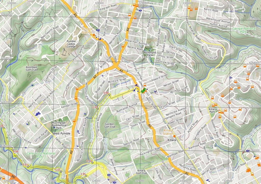
1 Gordon to Hornsby (overnight at Scout camp) 2 Days Hard track 25.8 km One way 4 125m This overnight walk starts from Gordon train station and winds through bush filled valleys to Hornsby station. From Gordon station, the walk winds down past the Gordon golf course to the Great North Walk, then continues north through the Lane Cove Valley before staying overnight at the Baden Powell scout camp. The next day, the walk continues along the Great North Walk, through Thornleigh and down into the Berowra Valley Regional Park, following Berowra creek to the beautiful Fishponds waterhole. From here, the walk passes up through a piece of the old Blue Gum High Forest to Hornsby Quarry, and on to Hornsby train station. 184m 9m Berowra Valley National Park Maps, text & images are copyright wildwalks.com Thanks to OSM, NASA and others for data used to generate some map layers.

2 Browns Waterhole Before You walk Browns Waterhole is a wide, shallow section of the Lane Cove River, downstream of a concrete weir. There is a concrete shared cycle/footpath crossing over the top of the weir, linking Kissing Point Road, South Turramurra to Vimiera Rd, Macquarie Park. On the western side of the waterhole, there is a picnic table and small clearing with a view over this section of the river. Bushwalking is fun and a wonderful way to enjoy our natural places. Sometimes things go bad, with a bit of planning you can increase your chance of having an ejoyable and safer walk. Before setting off on your walk check Conscript Pass Conscript Pass is a small sandstone pass between the Lane Cove River and Thornleigh, on the Great North Walk. During the 193s, some stone steps were built through a cleft in the rock as part of a public works program, in response to the depression. The pass has two main engravings. Firstly 'Conscript Pass' is followed with a downwards pointing arrow and a series of initials and numbers. On another wall (that you face when walking up) is engraved 'B Stevens' followed a surprisingly good caricature of the then Premier of NSW, Bertram Stevens. Stevens (later knighted) replaced Jack Lang in 1932 as Premier of NSW, when Lang was dismissed by the Governor (just two months Lang after opening the Sydney Harbour Bridge). Baden Powell Scout Centre The Baden Powell Scout Centre is a large camping and training area on the edge of Pennant Hills and Thornleigh (at the end of Pomona St). There are several large buildings including dining and training halls. For walkers, there is dorm/hostel style accommodation and several bush camping areas. Bush camping - is found near the lower (south-eastern) end of the grounds for $9 per person per night. Facilities include tap water, picnic shelters, toilets and even a shower block. They also provide an indoor area in case the weather turns during the night and you need to retreat. There are kitchen facilities available for an extra $5. Dorm-style accommodation - at $29 per person per night, you can share a room with other campers in a bunk room, you will need to bring a sleeping bag and towel. Hostel-style accommodation - at $35 per person per night, you will be provided a smaller room (still shared) with bedding (sheets and blankets) as well as access to a kitchen. The friendly staff here are also happy to put together a food hamper for your meals, or organise a delivery meal, just chat with them when booking. Pre-booking is essential, phone Michael New (2) (weekdays). End of day 1 This is the planned overnight stay for the end of day 1, happy camping. 1) Weather Forecast (BOM Metropolitan District) 2) Fire Dangers (Greater Sydney Region) 3) Park Alerts (Berowra Valley National Park, Lane Cove National Park) 4) Research the walk to check your party has the skills, fitness and equipment required 5) Agree to stay as a group and not leave anyone to walk solo Think before you TREK The 'Think before you TREK' program developed by NSW Police & NPWS promotes the benefits of planning ahead for your bushwalking trip by using an easy to remember acronym: adequate supplies of food, water, navigation and first T Take aid equipment. your planned route and tell friends and family when R Register you expect to return. beacon (PLB's) should be carried on walks with E Emergency significant gaps in mobile coverage (check terrain profile). to your planned route and follow the map and walking K Keep trails. Topo Maps The maps provided on wildwalks are helpful, but there are times where you may need maps covering a broader area. Maps that cover this walk include; 1:25 Map Series:9134S HORNSBY, 9133N PARRAMATTA RIVER 1:1 Map Series:913 SYDNEY Grade This walk has been graded using the AS The overall grade of the walk is dertermined by the highest classification along the whole track. 4 Grade 4/6 Hard track Length 25.8 km One way Time 2 Days Quality of track Rough track, where fallen trees and other obstacles are likely (4/6) Signs Minimal directional signs (4/6) Experience Required Moderate level of bushwalking experience recommended (4/6) Weather Storms may impact on navigation and safety (3/6) Infrastructure Limited facilities, not all cliffs are fenced (3/6)
3 Are you ready to have fun? Please ensure you and your group are well prepared and equipped for all possible hazards and delays. Check park closures, weather information and Fire Danger Rating before setting out. Optional side trips and alternate routes noted are not included in this walks overall grade, length or time estimate. Please allow extra time for resting and exploring areas of interest. The authors, staff and owners of wildwalks take care in preparing this information but will not accept responsibility for any inconvenience, loss or injury you may experience. Please take care, have fun - Happy Walking. Getting there You can get to Gordon Station (gps: , ) by car, train or bus. Car: There is free parking available. You can get back from Hornsby Train Station (gps: , ) by car, train or bus. Car: There is free parking available. Find up to date and more information inlcuding; travel directions, weather, park closures and walker feedback at Gordon Station (98 m 2 mins) From the top of the station, this walk heads towards the shops, down the stairs and to the road next to Gordon Station bus depot. Continue straight: From Gordon Station bus depot, this walk heads up the hill of St Johns Ave to the Pacific Highway. The walk crosses to the other side at the pedestrian crossing. From here, this walk follows the shop fronts up the Pacific Highway, then turns left onto Moree St. This street is followed until the walk turns right onto Vale St. This walk continues along Vale St for a short time to the intersection with the bush track on the left of the street..98 Int. Blackbutt Creek Trk and Vale St (43 m 8 mins) Turn left : From the intersection next to house No. 31, this walk heads past a gate to follow a line of houses on the right. The track continues down a slight gradient for approximately 3m, turning left to come to the intersection, approximately 1m above a concrete sewerage inspection hole. Veer left: From the intersection, this walk heads down the hill, passing a concrete sewerage inspection hole on the right. The trail continues along the creek line for another 2m, to the intersection which leads down to the creek on the right Int. Blackbutt Ck Pathway and Blackbutt Ck Trail (1.3 km 25 mins) Continue straight: From the intersection, this walk follows the creek downstream for approximately 2m to the signposted intersection. Continue straight: From the intersection, this walk follows the left-hand arrow on the 'Blackbutt Creek Track' sign, down the hill. The track contours with the creek on the right, and the houses high on the left, for approximately 1km to then steeply descend to the intersection above the concreted watercrossing. Continue straight: From the intersection, this walk heads down the hill, across the concrete ford (creek), to then turn right and follow along side the creek. The trail tends left away from the creek, up to a white gate Int. Lady Game Drive and Falls Creek Trk (1.2 km 23 mins) Turn left : From the white metal gate, this walk heads up the hill along Lady Game Dr, crossing to the right side where safe. This walk then turns right on De Burgh Rd, then right again onto Beaumont Rd. At the end of Beaumont Rd, this walk turns left onto Blaxland Rd, then comes to an intersection at 'Allen Park' at the end of Blaxland Rd Allen Park (1.1 km 23 mins) Veer right: From the corner of Terrace and Blaxland Roads, this walk heads around the locked gate and then straight across the grassy clearing of 'Allen Park'. The walk soon tends left at the 'Lane Cove National Park' sign and follows a wide trail down through the bush for about 6m, coming to an intersection where a 'Terrace Rd' sign points back up the hill. Continue straight: From the intersection, the walk follows the 'Great North Walk - Deburghs Bridge' sign downhill along the wide management trail. The trail soon bends right and follows the power lines down, stepping over a partially buried, green metal pipeline (sometimes hissing). After this, the trail follows a GNW arrow left as the trail significantly narrows and leads down a series of timbers steps then across the rocky Blackbutt Creek. Here, the walk follows the GNW arrow up onto the rock platform, where the track turns left then leads along the flat to a T-intersection with a GNW arrow post, and a set of steps (up to your right AND down to your left). Turn right: From the intersection, the walk follows the GNW arrow post up the timber steps. The track then leads up some stone steps and comes to a three-way intersection, where a sign points back to 'Lane Cove River Weir via Great North Walk'. Continue straight: From the intersection, this walk follows the 'Thornleigh via Great North Walk' sign down a couple of steps and along the track towards Deburghs Bridge, keeping the valley to your left. After about 5m, the track leads under the large concrete Deburghs Bridge, with some graffiti. On the other side of the bridge, the track bends right to head up over some rocks, following two sections of hand railing. From the end of these handrails, the track leads gently up among the grass trees for about 4m (and a weedy section of track) to come to a clear T-intersection with a management trail, where a 'Great North Walk' sign points back down the track. 5.7 Int of GNW and Ryde Road trail (west) (9 m 19 mins) Continue straight: From the intersection, this walk follows the 'The Great North Walk' sign north, gently downhill along the management trail. After about 8m, this trail crosses a concrete bridge over Rudder Creek (beside a concrete sewerage pipe). From here, the trail leads uphill for just shy of 2m to come to an intersection with the GNW track (on your left), where a 'Lane Cove Weir' sign points back down along the trail. Turn left: From the intersection, this walk follows the 'Thornleigh Oval' sign west, gently down the track, away from the management trail. The track almost immediately passes the large metal pipe (crossing the Lane Cove River) then winds down the rocky track for about 2m, through open eucalypt forest with some limited views left over the valley, to come to a weedy section of track marked with a concrete sewerage access point. Here the track mostly flattens out and leads along the side of the hill for about 4m to head down a few steps and cross Quarry Creek. The walk then heads up some steps and follows the track for another 3m to come to a Tintersection with the Gloucester Ave fire trail, marked with a GNW and NPWS arrow post. Turn left: From the intersection, the walk follows the GNW arrow post gently uphill along the management trail, away from the gate whilst keeping the power line poles on your left. After about 3m (just past the second power pole), this trail leads to an intersection with a track (on the left), marked with another set of NPWS & GNW arrow posts (just under the high tension power lines) Int of GNW and Gloucester Ave service trail (sth) (69 m 15 mins) Turn left: From the intersection, this walk follows the GNW arrow post south, downhill along the track and under the high tension power lines. The track winds gently downhill for almost 15m until, just after passing close to the the high tension power line tower, this walk comes to a locked green shed opposite a fenced-off pipe bridge (down in the valley to your left). Continue straight: From the green shed, this walk follows the track along the side of the hill, keeping the valley to your left (running parallel with the high tension power lines, up to your right). After about 15m, this walk comes to an intersection with a faint track on your right (that leads a short distance to a management trail), marked with a GNW arrow post. Continue straight: From the intersection, this walk follows the GNW arrow post along the mostly flat track, through the dense forest, and almost immediately passes a concrete sewerage access point. After about 7m, this walk heads down a few timbers steps to cross a small gully, where the track continues for another 1m (passing close to a few houses), then crosses two flat timber bridges over Congham Creek. Here the walk veers left up onto the rock platform and follows the track gently uphill for another 8m to come to a three-way intersection, marked with a GNW arrow post (and a sign pointing left to 'Marsfield'). Veer right: From the intersection, the walk follows the GNW arrow post north, uphill for about 3m to come to a faint intersection with a track (on your right) marked with a GNW arrow post. Veer left: From the intersection, this walk follows the GNW arrow post gently uphill along the side of the hill (keeping the valley to your left) for about 1m to come to a small clearing and three way intersection, marked with yet another GNW arrow post and a pile of rocks (on your left) Int of the GNW and mid Gloucester Ave fire trail a (62 m 14 mins) Turn left : From the intersection, this walk follows the GNW arrow post up the short rocky hill and away from the high tension power lines. The track (rocky early on) leads along the side of the hill among some grass trees for about 3m before passing under the power lines again. Here the track continues for another 3m along the side of the valley to come to a clear intersection with intersection with a wide management trail Int of the GNW and the West Pymble service trail l (21 m 4 mins) Continue straight: From the intersection, this walk follows the GNW arrow post downhill along the management trail. The trail leads down for about 7m to cross a small gully then runs closely beside the Lane Cove River (on your left) for another 12m to come to an intersection marked with a GNW arrow post and a 'Lane Cove Valley' aluminum sign and map Int of the GNW and the Avondale creek service trai (49 m 13 mins) Turn left : From the intersection, this walk follows the GNW arrow post, directly away from the face of the 'Lane Cove Valley' aluminum sign and map, down the track and timber steps to a sandy beach on the Lane Cove River. Here the walk turns right to cross the weir and bridge over Avondale Creek, (this may become impassable after heavy or prolonged rain) then climb gently uphill for about 12m to come to a faint intersection with a faint track (on your left - this faint track leads down to another old weir). Continue straight: From the intersection, this walk heads gently uphill following the main track, whilst keeping the valley to your left for about 3m to come to a clear Y-intersection marked with a GNW arrow post. Veer left: From the intersection, this walk follows the GNW arrow post along the track, keeping the Lane Cove River a short distance to your left. After about 8m, the track steps up to and crosses a short section to timber boardwalk/bridge. Here the walk climbs up the rocky hill following a series of concrete access points and timber steps for about 23m to come to a Tintersection with a management trail, marked with a GNW arrow post Int of the GNW and the Turramurra High School serv (84 m 17 mins) Veer left: From the intersection, this walk follows the GNW arrow post gently downhill along the management trail for about 4m to come to an intersection with a short trail (on the right, which leads to the gate at the end of Koombalah Ave). Continue straight: From the intersection just below the Koombalah Ave gate, this walk follows the management trail gently downhill, whilst keeping the valley to your left. The trail initially leads over a rock platform, then about 5m later, leads down a steep hill. The trail then heads gently down for about
4 4m before a short steep hill leads down to a metal high tension power line tower. Here the trail bends right and leads down and along the side of the hill for another 2m to pass another high tension power line tower and head behind a few houses. Just behind the second house, this walk comes to ephemeral creek on a rock platform Creek crossing (3 m 6 mins) Continue straight: From here, this walk crosses the ephemeral creek (keeping the houses up to your right) and continues along the trail for about 3m to come to a T-intersection with a wide, shared, concrete path, marked with several signposts. Turn left: From the intersection, this walk follows the GNW arrow post downhill along the wide, shared, concrete path. After about 5m, this path leads under some high tension power lines then bends right. About 5m after passing under the power lines, this path leads to an intersection with a track (on your left, that leads to an informal unfenced lookout), just before a GNW arrow post. Continue straight: From the intersection, the walk heads fairly steeply downhill along the concrete path. The path passes a few signs over about 1m, then comes to an intersection with a track (on your left), marked with a timber barricade and a GNW arrow post. Veer right: From the intersection, this follows the concrete path downhill for just shy of 5m to come to a intersection with a dirt management trail. This intersection is beside the Lane Cove River crossing (on your left) and is marked with a 'The Great North Walk' sign here Browns Waterhole Browns Waterhole is a wide, shallow section of the Lane Cove River, downstream of a concrete weir. There is a concrete shared cycle/footpath crossing over the top of the weir, linking Kissing Point Road, South Turramurra to Vimiera Rd, Macquarie Park. On the western side of the waterhole, there is a picnic table and small clearing with a view over this section of the river Browns Waterhole int (57 m 12 mins) Veer right: From the intersection, this walk follows the 'The Great North Walk' sign along the dirt management trail, keeping the Lane Cove River to your left. After about 8m, the trail leads under some high tension power lines, where there is a mostly clear view over the river (to your left). The trail then gently leads down through the valley for about 4m to come to an intersection with Cove St trail, marked with a GNW arrow post. Veer left: From the intersection, this walk follows the GNW arrow post downhill along the management trail for about 3m to cross a small culverted creek. The walk then follows the trail up the short hill to come to an intersection with the signposted 'STEP track' (on your right) Int of GNW and the STEP track (east) (58 m 1 mins) Continue straight: From the intersection, this walk follows the GNW arrow post and STEP Track markers along the management trail, whilst keeping the river to your left. The trail undulates through the valley (weedy in places) and tall forest for just shy of 6m, to come to a clear intersection at the bottom of a sealed management trail (on your right). This intersection is marked with another 'STEP Track' map/sign and a 'The Great North Walk' sign Int of GNW and the STEP track (west) (2.2 km 39 mins) Veer left: From the intersection, the walk follows the 'The Great North Walk' sign gently downhill along the management trail, directly away from the face of the 'STEP Track' map/sign. Keeping the river to your left, the trail leads downhill for about 8m to come to a Y-intersection, where there is a 'Lane Cove Valley' map/sign and a 'Lane Cove River Park' sign pointing back along the trail. Veer right: From the intersection, this walk follows the 'Thornleigh Station' sign past the 'Lane Cove Valley' map, initially keeping the other trail and river to your left. The trail follows the valley floor, keeping the river just to your left, for a bit over 5m, to then cross the Lane Cove River at a rocky ford. This crossing may become impassable after heavy or prolonged rain. On the other side of the river, this walk continues along the trail for about 4m (with the river now close by on your right) to come to an intersection with a faint track (on your left, that leads up towards Pennant Hills Park). Continue straight: From the intersection, the walk follows the management trail, keeping the river just to your right. After about 6m, the trail bends right and crosses the Lane Cove River at a rocky ford, then continues along the valley floor among the fern trees (and concrete pipe access points) for about 9m to cross the Lane Cove River again at another rocky ford. (These crossings may become impassable after heavy or prolonged rain). The trail then continues along the valley floor (with the river now on your left) for just over 15m to come to an intersection at the bottom of the sealed Morona Ave trail (on your right), marked with a 'Lane Cove Valley' map/sign and a GNW arrow post Int of the GNW and the Morona Ave trail (33 m 8 mins) Veer left: From the intersection, this walk follows the GNW arrow post along the valley floor, away from the two trails, keeping the river just to your left. The track soon narrows, leading past a water depth indicator, and becomes rocky for about 15m before coming to a faint intersection, where GNW arrow post points left. Here, the walk turns left and crosses the Lane Cove River using the concrete stepping stones (this crossing may become impassable after heavy or prolonged rain) to follow the 'Thornleigh Station' sign up the timber steps for about 4m and find a GNW registration box (damaged at time of writing). The track bends sharply right and zigzags up the rocky hill for another 3m, before bending sharply left to find the 'Conscript Pass' and 'B Stevens' engravings (at the third metal hand rail) Conscript Pass (1 m 3 mins) Continue straight: From 'Conscript Pass', this walk heads up the stone steps through the cleft in the rock to follow the track and more stone steps uphill for about 1m, coming to a T-intersection with Lorna Pass track, marked with a GNW arrow post Conscript Pass Conscript Pass is a small sandstone pass between the Lane Cove River and Thornleigh, on the Great North Walk. During the 193s, some stone steps were built through a cleft in the rock as part of a public works program, in response to the depression. The pass has two main engravings. Firstly 'Conscript Pass' is followed with a downwards pointing arrow and a series of initials and numbers. On another wall (that you face when walking up) is engraved 'B Stevens' followed a surprisingly good caricature of the then Premier of NSW, Bertram Stevens. Stevens (later knighted) replaced Jack Lang in 1932 as Premier of NSW, when Lang was dismissed by the Governor (just two months Lang after opening the Sydney Harbour Bridge) Int of the GNW and Lorna Pass tracks (84 m 2 mins) Veer left: From the intersection, the walk follows the 'Thornleigh' sign uphill along the rocky track, keeping the valley to your left. The track leads up a series of timber steps for about 23m, becoming steeper as they go, to come to a clear T-intersection signposted with a large 'The Great North Walk' sign, and a stone 'Lorna Pass' arrow pointing back down the track. Turn left : From the intersection, this walk follows the 'Baden Powell Scout Centre' sign gently down along the side of the hill for just shy of 4m to come to a four-way intersection, where a 'Thornleigh Oval' sign points back along the track. Continue straight: From the intersection, this walk follows the 'Baden-Powell Scout Centre' sign and the GNW arrow post west along the narrow track. The track leads through the dense heath for about 12m to come to an intersection and clearing at a rocky outcrop, marked with a GNW arrow post. Turn right: From the clearing, this walk follows the GNW arrow post north, downhill along the narrow track. After about 12m the rocky track leads to a small flat clearing where this walk turn left (following the GNW arrow post) passing through about 2m of heath to come to another clearing (with a campfire scar). Following the GNW arrow post, this walk soon bends right to step down to the edge of a creek. Here the walk turns left and follows the creek downstream for about 2m to then bend right and cross Scout Creek. The walk then heads uphill along the widening track for about 13m (passing a few scout constructions, and a track on the left) then walks up under the high ropes course. About 2m after the ropes course, this walk comes to an intersection with a dirt driveway, beside the green Pioneer Hut (shed on the left). There is also a tap and drinking fountain here. Turn right: From the intersection, this walk follows the gravel driveway east, away from the Pioneer Hut and towards the picnic shelters. After about 3m (just after the left bend), this walk comes to some of these picnic shelters and several tiered platforms (on your right) - this is the camping area (there is a stone building up to your right) Baden Powell Scout Centre The Baden Powell Scout Centre is a large camping and training area on the edge of Pennant Hills and Thornleigh (at the end of Pomona St). There are several large buildings including dining and training halls. For walkers, there is dorm/hostel style accommodation and several bush camping areas. Bush camping - is found near the lower (south-eastern) end of the grounds for $9 per person per night. Facilities include tap water, picnic shelters, toilets and even a shower block. They also provide an indoor area in case the weather turns during the night and you need to retreat. There are kitchen facilities available for an extra $5. Dorm-style accommodation - at $29 per person per night, you can share a room with other campers in a bunk room, you will need to bring a sleeping bag and towel. Hostel-style accommodation - at $35 per person per night, you will be provided a smaller room (still shared) with bedding (sheets and blankets) as well as access to a kitchen. The friendly staff here are also happy to put together a food hamper for your meals, or organise a delivery meal, just chat with them when booking. Pre-booking is essential, phone Michael New (2) (weekdays) End of day 1 This is the planned overnight stay for the end of day 1, happy camping.
5 13.74 BP camping area (45 m 1 mins) Turn around: From the camping area, this walk follows the gravel driveway south, whilst keeping the valley to your left. The driveway bends right and, after about 3m, comes to an intersection with a wide track (on your left) just before a green shed - the 'Pioneer Hut'. Turn left: From the intersection, this walk follows the track downhill, initially keeping the green Pioneer Hut (shed) on your right. After about 2m, the track begins to narrow and heads under the high ropes course. The walk continues downhill for about 13m (passing a track on the right and a few scout constructions) to cross Scout Creek. Here the walk bends left and follows the creek for about 2m before turning right, and stepping up, at a faint intersection. The track then veers left to find a clearing (with a campfire scar) then about 2m through the heath on the other side, this walk finds another flat clearing. Here the walk turns right and follows the GNW arrow post up along the rocky track for about 12m to come to a rocky outcrop and clearing marked with another GNW arrow post Int of BP camp and unnamed track (37 m 7 mins) Turn left: From the intersection, this walk follows the GNW arrow post up over the rocky outcrop to head east (ignoring the faint track on your right). This narrow track leads through the dense heath for about 12m to come to a four-way intersection, where a 'Baden-Powell Scout Centre' sign points back along the track. Continue straight: From the intersection, this walk follows the 'Thornleigh Oval' sign gently up along the side for the hill for about 4m to come to an intersection with 'Lorna Pass' (on your right), and a large Great North Walk sign pointing back to the 'Baden Powell Scout Centre'. Continue straight: From the intersection, this walk follows the GNW arrow post and 'Thornleigh Station' sign uphill along the wide rocky track. After just over 15m, the track bends left (ignoring a faint track on your right) and heads uphill for another 4m to come to the back (south-east corner) of Thornleigh Oval, marked with a 'Lane Cove National Park' signpost Back of Thornleigh Oval (16 m 3 mins) Turn right: From the intersection, this walk follows the GNW arrow post along the fence line around the oval, keeping the oval to your left. After about 1m, this walk passes in front of the clubhouse (there are toilets and a water tap on your right) to pass a 'Great North Walk' sign and come to the corner of 'Handley' and 'Ferguson' Avenues in front of the 'Thornleigh Oval' sign Thornleigh Oval Thornleigh Oval is found at the intersection of Handley and Ferguson Avenues, Thornleigh. There is a large playing field, tap water, public toilets and some shelter in the awning of the club house. The oval has a car park, and a number io signs for the Great North walk and other local tracks Int of Handley and Ferguson Avenues (92 m 16 mins) Continue straight: From the intersection, this walk follows the 'Thornleigh Station' sign across the road to follow the footpath beside 'Handley Ave'. After about 13m, the walk crosses Clifford Ave then after about 25m, crosses 'Orchard St' to follow 'Station St' almost directly ahead. About 19m along 'Station St', this walk continues straight across 'Wood St' (you can get to Parkway Plaza if you turn right here) and continues for just over 2m to find a footbridge beside Pennant Hills Rd. Here the walk heads up the ramp and crosses over the busy road then down the ramp (or steps) to find the intersection with Railway Parade. Veer left: From the base of the steps, this walk follows the GNW arrow across 'Railway Pde', heading towards the train line. At the fence, this walk veers left and leads along the pedestrian alley for about 6m before turning right and climbing up the railway bridge steps, coming to the 'Thornleigh' Train Station. North Walk' and the Stringybark Ridge management trail (signposted 'Cherrybrook Lakes' trail) Thornleigh Train Station (99 m 18 mins) Continue straight: From the western (north bound) side of Thornleigh Station, this walk follows the 'Jungo Rest Area' sign along the footpath towards the car park and The Esplanade. The walk then heads down a short distance further to turn left and cross 'The Esplanade' at the traffic lights, then continue straight along the footpath down along Eddy Rd. Following a couple of GNW arrows down Eddy Rd as it then bends left, turning into Tilock St, and shortly later this walk then turns right into Morgan St. Continuing down till just before the end of this street, this walk comes to an intersection marked with a GNW arrow and the 'Elouera Bushland Natural Park' sign (on the right) Int of GNW and Stringybark Ridge trail (1 km 27 mins) Turn right: From the intersection, this walk follows the 'Great North Walk' sign down the narrower track. The track leads downhill for about 7m, getting steeper as it goes, and then crosses Berowra Creek - this creek may become impassable after rain. On the other side, the walk comes to an intersection on a small sandy beach. Here, the walk turns left, following the GNW arrows downstream for about 25m among the grass trees and crossing a flat timber bridge. The rocky track then continues for just shy of 25m and crosses a mossy gully on a large flat rock. The track then continues, staying fairly flat for another 17m before bending right and heading steeply uphill. At the top of this climb, the track soon leads to a section of fenced cliff. At the end of the fence, the walk passes through casuarina forest for a short distance before passing alongside another (longer) fenced cliff and coming to the Elouera Lookout, where there is an intersection with the 'Westleigh' track (on your right) Morgan Rd (23 m 4 mins) Turn right: From the end of Morgan Street, the walk follows the GNW arrow and the 'Elouera Bushland Natural Park' sign between houses no. 28 and 26. Once behind the houses at a small clearing, the track turns left and follows down the rocky side of Zig Zag Creek. Soon after passing behind the third house, the track comes to an intersection with a wide concrete trail, where a sign points back along the track to 'Sydney Cove' Int of Bike Trail and Morgan Rd tracks (14 m 2 mins) Turn right: From the intersection, this walk follows the 'The Jungo' sign downhill along the wide concreted trail, and soon crosses over the culverted creek (with green side rails). The walk continues down into the valley, coming to a signposted intersection marked with a 'Great North Walk' sign (on your left), just before Zig Zag Creek and the long bridge Thornleigh zigzag railway The Thornleigh zigzag railway originally ran from the main rail line near Thornleigh to an historic quarry, near present day De Saxe Cl, Thornleigh. There are only minor fragments still visible today. The 'Heritage Trail' in Thornleigh has interpretive signs for the railway and the old Thornleigh Quarry. A book is available with some detail on railway and associated quarry: 'Sydney's Forgotten Quarry Railways' by John Oakes, ISBN Zig Zag Creek Bridge intersection (1.4 km 25 mins) Turn left: From the intersection, this walk follows the 'Great North Walk' sign along the narrower track, keeping the gully to your right. The pleasant track leads into, then through, the ferny forest with tall trees for about 7m, before crossing a side creek on a timber bridge. The track then continues in a similar manner for another 7m, coming to a large clearing and campsite, The Jungo. On the far side of this clearing is a well-signposted intersection with a 'Bellamy Street' sign pointing back through the campsite The Jungo The Jungo is a relatively small clearing and campsite near the junction of Berowra and ZigZag Creeks at a well signposted intersection. There is often water in the creeks (treat well before drinking) but there are no facilities. Speculation on the source of the name 'Jungo' includes the Aussie tendency to abbreviate words ('Junction' gets corrupted to 'jung-o' etc) as well as a possible derivation from one of a few similar sounding aboriginal words Jungo campsite (1 m 2 mins) Veer right: From the campsite, this walk follows the 'Fishponds' sign down across the concrete ford, over the usually small creek. Here, the concrete management trail leads uphill, becoming dirt as it starts to flatten out. This walk then comes to a signposted intersection of the 'Great Elouera Lookout This fenced lookout is on the Benowie Track close to Westleigh. There are uninterrupted views from the clifftop across the Berowra Creek valley, which is rare for the area. As well as being on the Great North Walk, this lookout can be accessed by a short walk from Elouera Rd, Westleigh. This section of fenced rock platform is about 1m long, and there is some limited shade from the casuarina near the lookout if you want to take a rest Elouera Lookout (2.8 km 1 hr 1 mins) Continue straight: From Elouera Lookout, this walk follows the 'Great North Walk' sign along the track, keeping the fence and valley to your left. At the end of the fence, the walk bends left following the rocky flat track for about 2m, where the track then becomes progressively steeper for about 25m, winding steeply down then across a flat timber bridge. From here, the track leads beside Berowra Creek for a short time before crossing another flat timber bridge. The track then passes among the pleasant grass trees for about 2m (crossing a couple of small creeks with timber plank spans) to then climb a few sets of timber steps and cross a small (often dry) creek. From here, the track gently winds up along the side of the hill for about 8m, passing through a pleasant casuarina forest then heading across a rocky creek on another small, flat, timber bridge. Just over 1m later, the track crosses a smaller (often dry) creek to then wind uphill for about 1m to a three-way intersection with the signposted 'Quarter Sessions Rd' track (on your right). Veer left: From the intersection, this walk heads north along the main rocky track, keeping the valley down to your left. The track leads along beside a rock wall (which is on your right) and through a rock outcrop, where the track soon heads quite steeply uphill along the eroded track for a short time. At the top of this steep section, the rocky track continues to meander much more gently up along the side of the hill for about 3m, then crosses a small, rocky gully, just below some houses. The track then continues gently uphill for about 1m to an intersection with the unsignposted Blackfellows Head track (on your right) Int of the GNW and the Blackfellows Head lookout t (1.1 km 23 mins) Continue straight: From the intersection, this walk heads north along the clear track, keeping the valley down to your left for about 1m, where the walk comes to a three-way intersection and 'The Jungo' sign points back along the track. Veer left: From the intersection, this walk follows the 'Fishponds' sign past the 'Berowra Valley Regional Park' sign, gently uphill along the narrow ridge. The track is mostly flat for about 2m before it starts to head fairly

6 steeply down over some rocks and down a set of rock steps. This area comes alive with Patersonia lilies and pink wax flowers in early spring. The track then continues fairly gently down along the narrow ridge for another 2m before leading through a crack in a rock, then down a bit further to climb down through a particularly steep rocky section. Near the bottom of this descent, this walk passes a couple of arrow posts, where the track bends right to pass below a large rock overhang. Just beyond this overhang, the track bends left and leads across Waitara Creek at the interesting holes in the rock know as 'the spa'. This creek may become impassable after heavy rain, the rocks can also be slippery. Across the creek, the walk comes to a large rock platform and a Blue Gum Track post. After stopping to enjoy cool spot, this walk continues left along the unfenced rock platform (keeping the creek down to your left). The walk soon steps off this large rock (at the far right-hand corner, through the fork in a tree). This walk heads over another rock platform, then along a notably flat section of track (now with Berowra Creek on your left), passing beside some cascades for about 1m before climbing up and over some rocks and under a sandstone overhang. The track leads around the side of the hill for about 1m, then down to cross a small creek using the small flat timber bridge. The walk then climbs up some timber steps to a fenced lookout over Fishponds, at a well-signposted intersection. A sign points back along the track to 'Thornleigh Station' Fishponds Lookout Fishponds Lookout is a fenced rock platform at the intersection of the Benowie walking track and the Rosemead trackhead. It is marked with a number of Great North Walk signs. This informally named lookout has good views down over Fishponds, a large waterhole on Berowra Creek. Looking north across the creek, there are views to the upper waterhole and the cliffs on the other side Optional sidetrip to Fishponds crossing (7 m 2 mins) Continue straight: From the lookout, this walk follows the 'Galston Gorge' sign along the fenced rock shelf (keeping the fence to your left). The track leads down the rocky steps to the edge of Berowra Creek. The walk crosses the creek using the stepping stones, and comes to a small cave on the other side. This creek may be impassable after rain. At the end of this side trip, retrace your steps back to the main walk then Turn left Fishponds Fishponds is a long waterhole on Berowra Creek in Berowra Valley Regional Park. The waterhole is lined with tall cliffs and a few sandstone caves. At the southern end, there are stepping stones to help cross the creek, and a small timber bridge at the northern end. This is a beautiful spot and a worthy place to rest and enjoy the water passing by. The waterhole is fairly popular with local teens in summer, cooling off. Swimming and jumping at the Fishponds waterhole has resulted in fatalities - please heed the signs and Cora's parents' plea and enjoy the water from the edge Fishponds Lookout (3 m 7 mins) Turn right: From the lookout, this walk follows the 'Rosemead Rd Trackhead' sign directly away from the view over Berowra Creek. After about 7m, the track leads over a timber footbridge, then leads up the side of the valley for about 1m to climb up the steep carved rock steps (with a hand rail). Here the track leads along the top of this unfenced cliff and soon comes to a well signposted three-way intersection, where a 'Fishponds' sign points back along the track. Continue straight: From the intersection, the walk follows the 'Hornsby Station' sign up along the track a short distance to come to an intersection with a wide management trail Int of Blue Gum Walk and Joes Mountain Service Tra (85 m 19 mins) Veer left: From the intersection, this walk follows the Great North Walk arrow south along the wide management trail, keeping the gully to your left. The walk climbs up the gentle hill for just over 3m, passing through the turpentine forest to a saddle and small clearing. Here the walk continues along the trail as it bends right (ignoring the track to the left) to leads downhill through the blue gum and bracken fern forest. The trail continues moderately steeply down until it bends left to cross Old Mans Creek at the concrete stepping stones. The trail leads left and gently up the hill, passing some houses (on your right) and soon comes to an intersection with a narrower track (on your left) after about 15m Int of GNW and Rosemead Rd service trail (3 m 1 mins) Veer left: From the intersection, this walk follows the Great North Walk arrow along the narrower track for a short distance, to Berowra Valley Bushland Park at the end of Rosemead Road Berowra Valley Bushland Park 'Berowra Valley Bushland Park' is also known as Rosemead Rd Park and is found at the bottom end of Rosemead Rd, Hornsby. This is an open area park surrounded by shady eucalyptus trees, making a pleasant spot to rest on a walk. It has a picnic table with bench seats, and a sheltered free electric BBQ. There is a water tap in the park, near the road. There is also a 'Welcome to Old Mans Valley' information sign with information about the traditional country of the Darug and Guringai peoples Berowra Valley Bushland Park (54 m 14 mins) Veer left: From the lower side of 'Berowra Valley Bushland Park', this walk follows the 'Hornsby Station' sign across the park, then follows the GNW arrow up the stone steps, keeping the houses to your right. The walk winds steeply up the steps, leaving the view of the house and finding a welcome flat section of track midway up. The steps then lead more steeply up the side of the valley, along the sheer rock walls for about 1m, and come to an intersection with the Quarry Road management trail, where a 'Great North Walk' sign points back down the the hill. Continue straight: From the intersection, this walk follows the GNW arrow post up a couple of timber steps and then follows the track as it winds up over the gentle rise. Once over the rise, the track then leads down to the intersection with Quarry Rd, where a 'Great North Walk' sign points back up the track Int of Quarry Road and GNW (72 m 14 mins) Turn right: From the intersection, this walk follows Quarry Road gently uphill away from the face of the 'Great North Walk' sign until just past a couple of house, this walk comes to an intersection with the gated 'Old Mans Valley' management trail (on your left). Continue straight: From the intersection, this walk follows Quarry Rd up the gentle hill for about 18m, then follows the GNW arrow left onto Dural St. The footpath leads past the unit block, then past a few shops to come to an intersection with the Pacific Hwy. Following the GNW arrow, this walk turns right across 'Dural St', passes a few more shops, then crosses 'Dural Lane' before turning left across the Pacific Hwy at the traffic lights. Here the walk continues straight across the 'Station St' pedestrian crossing, past the large 'Great North Walk' sign and across the bus lane to the western entrance of Hornsby Station.

7
8

9

10
11 Summary navigation sheet for the Gordon to Hornsby (overnight at Scout camp) km From Start Gordon Station , (GR Parramatta River, ).98 Int. Blackbutt Creek Trk and Vale St , (GR Parramatta River, ) 1.41 Int. Blackbutt Ck Pathway and Blackbutt Ck Trail , (GR Parramatta River, 28629) 2.74 Int. Lady Game Drive and Falls Creek Trk , (GR Parramatta River, ) 3.95 Allen Park , (GR Parramatta River, ) 5.7 Int of GNW and Ryde Road trail (west) , (GR Parramatta River, ) 5.97 Int of GNW and Gloucester Ave service trail (sth) , (GR Parramatta River, ) 6.66 Int of the GNW and mid Gloucester Ave fire trail access track , (GR Parramatta River, 26162) Up/Dwn Length Initial directions (Use full tracknotes and maps for more detail) m 2 mins 43 m 8 mins 1.3 km 25 mins 1.2 km 23 mins 1.1 km 23 mins 9 m 19 mins 69 m 15 mins 62 m 14 mins From the top of the station, this walk heads towards the shops, down the stairs and to the road next to Gordon Station bus depot. Turn left : From the intersection next to house No. Continue straight: From the intersection, this walk follows the creek downstream for approximately 2m to the signposted intersection. Turn left : From the white metal gate, this walk heads up the hill along Lady Game Dr, crossing to the right side where safe. Veer right: From the corner of Terrace and Blaxland Roads, this walk heads around the locked gate and then straight across the grassy clearing of 'Allen Park'. Continue straight: From the intersection, this walk follows the 'The Great North Walk' sign north, gently downhill along the management trail. Turn left: From the intersection, this walk follows the GNW arrow post south, downhill along the track and under the high tension power lines. Turn left : From the intersection, this walk follows the GNW arrow post up the short rocky hill and away from the high tension power lines Int of the GNW and the West Pymble service trail link track , (GR Parramatta River, ) m 4 mins Continue straight: From the intersection, this walk follows the GNW arrow post downhill along the management trail Int of the GNW and the Avondale creek service trail , (GR Parramatta River, ) m 13 mins Turn left : From the intersection, this walk follows the GNW arrow post, directly away from the face of the 'Lane Cove Valley' aluminum sign and map, down the track and timber steps to a sandy beach on the Lane Cove Int of the GNW and the Turramurra High School service trail , (GR Parramatta River, ) m 17 mins Veer left: From the intersection, this walk follows the GNW arrow post gently downhill along the management trail for about 4m to come to an intersection with a short trail (on the right, which leads to the gate at m 6 mins 57 m 12 mins 58 m 1 mins 2.2 km 39 mins 33 m 8 mins 1 m 3 mins Continue straight: From here, this walk crosses the ephemeral creek (keeping the houses up to your right) and continues along the trail for about 3m to come to a T-intersection with a wide, shared, concrete path, m... Veer right: From the intersection, this walk follows the 'The Great North Walk' sign along the dirt management trail, keeping the Lane Cove River to your left. Continue straight: From the intersection, this walk follows the GNW arrow post and STEP Track markers along the management trail, whilst keeping the river to your left. Veer left: From the intersection, the walk follows the 'The Great North Walk' sign gently downhill along the management trail, directly away from the face of the 'STEP Track' map/sign. Veer left: From the intersection, this walk follows the GNW arrow post along the valley floor, away from the two trails, keeping the river just to your left. Continue straight: From 'Conscript Pass', this walk heads up the stone steps through the cleft in the rock to follow the track and more stone steps uphill for about 1m, coming to a T-intersection with Lorna Pass t Creek crossing , (GR Parramatta River, ) 9.11 Browns Waterhole int , (GR Parramatta River, ) 9.68 Int of GNW and the STEP track (east) , (GR Parramatta River, ) 1.26 Int of GNW and the STEP track (west) , (GR Parramatta River, ) Int of the GNW and the Morona Ave trail , (GR Hornsby, ) Conscript Pass , (GR Hornsby, 23653)
Mt Kuring-gai Track to Berowra station
 Mt Kuring-gai Track to Berowra station 4 hrs 15 mins 9.7 km One way Hard track 4 553m This walk explores three valleys, with great displays of wild flowers in spring, and some nice sandstone overhangs.
Berowra Waters to Cowan Station
 Berowra Waters to Cowan Station 3 hrs 30 mins 7.2 km One way Hard track 597m This is a hilly walk out of the beautiful Berowra Waters valley to Cowan Station. There are many wide views across Berowra Creek
Hornsby station to Crosslands
 Hornsby station to Crosslands 6 hrs 45 mins 16.1 km One way Hard track 4 938m This section of the Great North Walk starts from Hornsby train station and winds down along the Blue Gum Walk into Fishponds.
Congewai Track Head (East) to Watagan Headquarters
 to Watagan Headquarters") Congewai Track Head (East) to Watagan Headquarters 7 hrs Hard track 17.2 km One way 4 973m This full day walk starts from the Congewai valley trackhead (east) and follows the Great North Walk up into the
Congewai Track Head (East) to Watagan Headquarters 7 hrs Hard track 17.2 km One way 4 973m This full day walk starts from the Congewai valley trackhead (east) and follows the Great North Walk up into the
Girrakool to Wondabyne station
 Girrakool to Wondabyne station 4 hrs Hard track 9.5 km One way 4 438m This walk starts from the Girrakool picnic area and winds south, through the Brisbane Waters National Park. The walk crosses some long
Erskine Creek via Pisgah Rock and Jack Evans
 Erskine Creek via Pisgah Rock and Jack Evans 4 hrs 30 mins 7.1 km Circuit Very experienced only 6 421m This walk visits some great lookouts and explores the lower section of Erskine Creek. Most of the
Leura Cascades to Gordon Falls Reserve
 Leura Cascades to Gordon Falls Reserve 1 hr 15 mins 1.8 km One way Moderate track 200m From Leura Park to Gordon Falls Park, this diverse walk offers fantastic views of the Jamison Valley, as well as two
Nature Track. 900m. 789m. 2 hrs 3.1 km Circuit. Hard track 238m. Blue Mountains National Park
 Nature Track 2 hrs 3.1 km Circuit Hard track 238m Largely following the ridges around the top edge of Wentworth Falls, this track is incredibly beautiful. After taking in the great views at Edinburgh Castle
Staples Lookout to Mt Wondabyne loop
 Staples Lookout to Mt Wondabyne loop 4 hrs 3 mins 1.8 km Circuit Hard track 337m This walk starts and finishes at Staples Lookout, on Woy Woy Rd. The walk follows sections of the Great North Walk around
Victoria Falls Lookout to Blue Gum Forest
 Victoria Falls Lookout to Blue Gum Forest 8 hrs Experienced only 13.8 km One way 5 112m This long day-walk follows a remote track down from Victoria Falls lookout, passing the waterfall, and into the Grose
Abbotts Falls Walking Track
 Abbotts Falls Walking Track 3 hrs 7.3 km Circuit Hard track 329m This circuit takes you through both dry and moist forest, using a combination of walking trails and wider tracks. The side trip to the dammed
Berowra to Cowan via Berowra Waters
 Berowra to Cowan via Berowra Waters 6 hrs Hard track 12.9 km One way 4 884m With train station at each end this walk explores the ridges and valleys around Berowra Waters. There are plenty of excellent
Berowra to Hornsby. 9 hrs 18 mins 22.6 km One way. Hard track. 1423m
 Berowra to Hornsby 9 hrs 18 mins 22.6 km One way Hard track 4 1423m One of the longer day walks in Berowra Valley National Park, this walk mostly follows Berowra Creek along the Great North Walk. Excellent
Merritts Traverse. 1928m
 Merritts Traverse 3 hrs Hard track 5.8 km Circuit 4 167m This walk starts with a scenic journey to the top of the hill on the chairlift. Starting along Merritts Nature walk, this walk soon detours down
Thornleigh to Cowan. 2 Days. Hard track 35.9 km One way. 2337m
 Thornleigh to Cowan 2 Days Hard track 35.9 km One way 4 2337m Following the Great North Walk and Berowra Creek through Berowra Valley Regional Park, this walk cuts straight through the length of the Park.
Crosslands to Cowan. 220m
 Crosslands to Cowan 7 hrs 30 mins 14 km One way Hard track 4 1103m This section of the Great North Walk starts from the Crosslands camping area and winds north alongside Berowra creek, passing through
Dadder Cave and Jack Evans track
 Dadder Cave and Jack Evans track 2 Days 10.3 km Circuit Very experienced only 535m This fairly short overnight walk is a great way to explore Erskine Creek. The walking along Erskine creek is mostly off
Jerusalem Bay Track (Cowan to Brooklyn)
") Jerusalem Bay Track (Cowan to Brooklyn) 5 hrs 30 mins 13.4 km One way Hard track 4 654m This Cowan to Brooklyn Station walk is a popular section of the Great North Walk, with scenery ranging from foreshore
Jerusalem Bay Track (Cowan to Brooklyn) 5 hrs 30 mins 13.4 km One way Hard track 4 654m This Cowan to Brooklyn Station walk is a popular section of the Great North Walk, with scenery ranging from foreshore
Girrakool to Wondabyne station via Pindar caves
 Girrakool to Wondabyne station via Pindar caves 7 hrs 30 mins 18.1 km One way Experienced only 5 741m This walk starts from the Girrakool picnic area and winds south, following Piles creek into the Brisbane
Crosslands to Berowra Waters return
 Crosslands to Berowra Waters return 6 hrs Hard track 13.7 km Return 4 1005m This return walk starts from the Crosslands Reserve and follows the Great North Walk along Berowra creek. The walk includes some
Guthega to Mt Twynam. 2183m. 1583m. 6 hrs 45 mins 14.8 km Return. Experienced only. 913m
 Guthega to Mt Twynam 6 hrs 45 mins 14.8 km Return Experienced only 5 913m This walk starts from Guthega and makes its way along the Snowy River to the Illawong Lodge, via the Blue Cow Creek flying fox.
Gibberagong Track. 169m
 Gibberagong Track 2 hrs 30 mins 6.5 km One way Hard track 4 180m Starting in suburban Wahroonga, this wellmaintained track follows Cockle Creek down to Bobbin Head in the Ku-ring-gai Chase National Park.
National Pass. 893m. 665m. 3 hrs 30 mins 4.6 km Circuit. Hard track 773m. Blue Mountains National Park
 National Pass 3 hrs 3 mins 4.6 km Circuit Hard track 773m 4 This walk offers fantastic views of the Jamison Valley and the surrounding cliffs. Take time to explore the historic and very scenic ledge halfway
Wentworth Pass. 893m. 535m. 4 hrs. Hard track 5.1 km Circuit. 692m
 Wentworth Pass 4 hrs Hard track 5.1 km Circuit 4 692m This walk offers a great way to explore the magical, upper section of the Valley of the Waters. The walk starts and finishes at Conservation Hut, which
Somersby to Yarramalong via Stringy Bark Point
 Somersby to Yarramalong via Stringy Bark Point 2 Days Hard track 26.7 km One way 4 1201m This section of the Great North Walk starts form the Somersby General Store and follows the Great North Walk north
Scenic Railway to Ruined Castle
 Scenic Railway to Ruined Castle 7 hrs 30 mins 12.4 km Return Hard track 4 963m This is a very popular, full day walk, in the Katoomba Area, offering great views of the valley. The walk follows the edge
Wondabyne station to Somersby Store
 Wondabyne station to Somersby Store 10 hrs Hard track 26.2 km One way 4 1164m This walk, following a section of the Great North Walk, starts from the Wondabyne train station and winds north, into the Brisbane
Crosslands to Brooklyn
 Crosslands to Brooklyn 2 Days Hard track 27.4 km One way 4 1757m From the Crosslands Reserve, this walk heads along the Great North Walk via Berowra Waters, Cowan, Jerusalem Bay and onto Brooklyn. This
Victoria Falls to Blackheath Station
 Victoria Falls to Blackheath Station 2 Days Experienced only 22.2 km One way 5 1561m This is a fantastic overnight walk with a sleep in Acacia Flats camping area. The Grose Valley, with its views of the
Victoria Falls and Grose Valley to Blackheath Station
 Victoria Falls and Grose Valley to Blackheath Station 3 Days Experienced only 22.5 km One way 5 158m This walk explores a fantastic section of the Grose Valley. Starting above Victoria Falls, the walk
Patonga to Staples Lookout
 Patonga to Staples Lookout 6 hrs 3 mins 17 km One way Hard track 4 72m This great walk explores much of the main ridge ridge running through Brisbane Water National Park. The walk visits a number of great
Patonga to Wondabyne station via Mt Wondabyne
 Patonga to Wondabyne station via Mt Wondabyne 7 hrs 3 mins 19.5 km One way Hard track 4 861m This walk explores some grand views, pleasant cascades, varied bushland and remote areas of Brisbane Waters
Leura to Katoomba via Dardanelles Pass
 Leura to Katoomba via Dardanelles Pass 4 hrs 6.6 km One way Hard track 697m With approximately equal parts cliff-walk and forest track, this track truly shows what the cliff edges of the Jamison Valley
Somersby to the Basin Campsite
 Somersby to the Basin Campsite 3 Days Hard track 47.4 km One way 4 2032m This three day walk starts at the Somersby General Store and follows the Great North Walk, heading north, into the the Jilliby State
Blackheath to Blue Gum loop
 Blackheath to Blue Gum loop 2 Days Hard track 24.1 km Circuit 4 1335m This walk is great for fit people getting into overnight walking, with its fantastic scenery and nostalgia as a classic overnighter.
Lady Carrington Drive
 Lady Carrington Drive 3 hrs 45 mins 9.7 km One way Moderate track 3 266m This walk follows the historic Lady Carrington Drive alongside the Hacking River. The old road is closed to traffic and provides
Cowan to Wondabyne station via Patonga rest area
 Cowan to Wondabyne station via Patonga rest area 2 Days Hard track 33.4 km One way 4 1523m This section of the Great North Walk starts from Cowan train station and wanders past the majestic Jerusalem Bay
Patonga to Wondabyne station via Pindar Caves overnight
 Patonga to Wondabyne station via Pindar Caves overnight 2 Days Experienced only 28.1 km One way 5 1164m This overnight hike starts from Patonga beach and winds along a section of the Great North Walk,
The Prince Henry Cliff Walk
 The Prince Henry Cliff Walk 3 hrs 30 mins 6.8 km One way Moderate track 3 575m Going from Katoomba to Leura, this walk covers the top of the cliff line and most of the major lookouts. With brilliant vistas
Main Range Track - Loop from Charlotte Pass camping near Mt Townsend
 Main Range Track - Loop from Charlotte Pass camping near Mt Townsend 2 Days Experienced only 27.7 km Circuit 5 1260m This great overnight walk starts from Charlotte Pass and provides access to some of
Main Range Walk - Charlotte Pass to Mount Kosciuszko
 Main Range Walk - Charlotte Pass to Mount Kosciuszko 9 hrs Hard track 21.9 km Circuit 4 920m This full day walk explores some of the greatest alpine country on offer in NSW. The walk grants views of Blue,
Victoria Falls and Grose Valley to Blackheath Station
 This walk explores a fantastic section of the Grose Valley. Starting above Victoria Falls, the walk explores the cascades before dropping into the valley for the first nights rest at Burra Korain campsite.
Katoomba to Wentworth Falls via the Jamison Valley
 Katoomba to Wentworth Falls via the Jamison Valley 2 Days Experienced only 29.2 km One way 5 2135m This is the two day version of this popular and challenging walk. This walk passes popular sights including
Guthega to Thredbo camping overnight at Wilkensons Creek
 Guthega to Thredbo camping overnight at Wilkensons Creek 2 Days Experienced only 25.8 km One way 5 1364m This great overnight walk explores the Kosciusko National Park between Guthega and Thredbo, visiting
COLOUR G U I D E. Sydney to Newcastle: Australia s most accessible long-distance walk
 COLOUR G U I D E Sydney to Newcastle: Australia s most accessible long-distance walk Woodslane Press Pty Ltd Unit 7/5 Vuko Place Warriewood, NSW 2102 Australia Email: info@woodslane.com.au Tel: (02)
Main Range Circuit from Guthega
 Main Range Circuit from Guthega 4 Days Experienced only 45 km Circuit 5 2317m This four day walk explores the Kosciuszko National Park, covering many of the key features of the park between Guthega and
Western Commission Track to Dubbo Gully
 This two day walk follows a series of historic roads along clear and wide management trails. This walk explores the great views from Western Commission Track, the sandstone handicraft on the Old Great
Out and about at Geehi
 Geehi Geehi Flats is a large area of flat floodplain on the banks of the Swampy Plains River. Located within Kosciuszko National Park, it is home to a popular campsite in summer for people wanting to enjoy
The Mendip Way. Route Directions and Maps Uphill to Wells
 The Mendip Way Route Directions and Maps Uphill to Wells Website: www.mendiphillsaonb.org.uk Email: mendip@mendiphillsaonb.org.uk Facebook & Twitter: @MendipHillsAONB Phone: 01761462338 1 Uphill to Loxton
Leaden Boot Challenge ROUTE INSTRUCTIONS
 Leaden Boot Challenge ROUTE INSTRUCTIONS Section 1 Alstonefield to Ilam From the village hall car park turn R then L and pass through the village keeping to the R to enter Church Street. Pass the Church
Leaden Boot Challenge 2016 ROUTE INSTRUCTIONS
 Leaden Boot Challenge 2016 ROUTE INSTRUCTIONS Section 1 Alstonefield to Ilam (CP2) From the village hall car park turn R then L and pass through the village keeping to the R to enter Church Street. Pass
Hindhead, Keffolds Copse and Gibbet Hill
 point your feet on a new path, Keffolds Copse and Gibbet Hill Distance: 6 km=4 miles Region: Surrey Author: Schwebefuss Refreshments: Punch Bowl Café moderate walking Date written: 14-apr-2015 Last update:
CWMGIEDD FROM ABERCRAVE
 Abercrave to Cwmgiedd Walk Page 1 Starting from The Abercrave Inn. Grid Ref: SN 824128 From the Abercrave Inn, an 11.3km (7 miles) walk to the foothills of the Cribarth Mountain, then through forest to
Slad over to Pitchcombe and back
 The walk climbs up from Slad over Wickridge Hill, descends to near Pitchcombe, then climbs back over Wickridge hill and round the back of Slad. Page 1 Start Point: SO 8718 0732 The Woolpack, Slad Length:
Sponsored by. statestreet.com
 /STATESTREETISLANDWALK #ISLANDWALKJSY Sponsored by statestreet.com Important Information If you forget everything else PLEASE remember the following.» Remember to check OUT of every checkpoint» If you
Pontfadog. Walk A. Walk A
 Walk A A Bird s eye view of the village 2km. (1 1 /2 miles); height gain 45m. (150ft) about 45 minutes. Six minutes walk along the main road towards Glyn Ceiriog reach a signpost to Llwynmawr. Take the
Plaquing Nomination for Thornleigh Quarry & Zig Zag Railway Page 2 LOCALITY PLAN 3 SITE MAP 4 PLAQUE NOMINATION FORM 6
 Plaquing Nomination for Thornleigh Quarry & Zig Zag Railway Page 2 Contents INTRODUCTION 3 LOCALITY PLAN 3 SITE MAP 4 PLAQUE NOMINATION FORM 6 PLAQUING NOMINATION ASSESSMENT FORM 7 1 BASIC DATA 7 2 ASSESSMENT
GOLDEN EARS PROVINCIAL PARK
 GOLDEN EARS PROVINCIAL PARK Trail Information as of October 10 th 2015 Do not underestimate the mountainous wilderness of Golden Ears Provincial Park. The combination of rugged terrain and rapidly changing
Self-Guided Walk Langdale Pikes. Start & Finish: NT car park (free to members) at Sticklebarn - on the right just beyond the New Dungeon Ghyll hotel.
 at Sticklebarn - on the right just beyond the New Dungeon Ghyll hotel.") Self-Guided Walk Langdale Pikes Key Information These mountains form a collection of spires and cliffs on the north side of Langdale. This walk visits four of the main tops Pavey Ark, Harrison Stickle,
Self-Guided Walk Langdale Pikes Key Information These mountains form a collection of spires and cliffs on the north side of Langdale. This walk visits four of the main tops Pavey Ark, Harrison Stickle,
Bewl Water & the High Weald
 1 Bewl Water & the High Weald Stonegate station - Stonegate - Wallcrouch - Newbarn - Cousley Wood - Wood's Green - Wadhurst station Length: 9 ½ miles (15.3km) Underfoot: Large portions of this path are
CAMPSITE 411. Girl Scouts of Greater Atlanta, Inc.
 CAMPSITE 411 Girl Scouts of Greater Atlanta, Inc. What is provided for us at each campsite/cabin? Although each living unit (tents or cabins) is unique, you can expect to find certain unit equipment in
DAY 1: Circular Quay to Greenwich Wharf
 DAY 1: Circular Quay to Greenwich Wharf Total Distance: 14km Time: Approximately 5 hours Walk Notes in Six Sections Section Name Length Time 1:1 Circular Quay to Milsons Point Station 2.5km 50mins 1:2
Trail Phasing Plan. Note: Trails in the Clear Creek Canyon area (Segments will be finalized in the future to minimize wildlife impacts
 Note: Trails in the Clear Creek Canyon area (Segments 2 5 and a future JCOS connection) will be finalized in the future to minimize wildlife impacts Trail Phasing Plan P Parking 3 Easy Trail Intermediate
Beautiful Walks from the Blue Ball Inn
 Walk No. 5 RIVER VALLEYS AND MOOR Countisbury, Watersmeet, Hillsford Bridge, Cheriton, Shilstone Hill, Rockford and Chiselcombe. 8.5 MILES APPROX. Walking time four and a half hours approx. OS 1;25,000
Printed in China by Designed by Coral Lee Main cover image: Broken Bay
 Woodslane Press Pty Ltd Unit 7/5 Vuko Place Warriewood, NSW 2102 Australia Email: info@woodslane.com.au Tel: (02) 9970 5111 Fax: (02) 9970 5002 http://travelandoutdoor.bookcentre.com.au First published
IRON BARK and COLENSO HUTS 260 Series Map: 1:50, U21 NZ Grid GPS: Geodetic Datum 1949
 IRON BARK and COLENSO HUTS 260 Series Map: 1:50,000 260-U21 NZ Grid GPS: Geodetic Datum 1949 Topo50 Map: BK36 Taoroa Junction GPS: on WGS84 How to get to START: Exit Taupo on SH1 down the lake to Turangi
HARDMOORS ROUTE DESCRIPTION
 HARDMOORS 60 2016 ROUTE DESCRIPTION RACE START (GUISBOROUGH) - CHECKPOINT 2 (SALTBURN) DISTANCE 9 MILES CUT OFF TIME 1030 GRID REF OS 666 208 1. Leaving the Sea Cadets Hall, turn left onto the road and
Difficult Run Stream Valley Park
 Difficult Run Stream Valley Park The more intense mountain bikers have known about for Difficult Run for some time. Equestrians have known it longer. Eight miles of unpaved trail, the Rails to River Trail
Tiger Mountain State Forest:
 98 60 hikes within 60 miles: SEATTLE 20 Tiger Mountain State Forest: West Tiger Mountain Three Loop i KEY AT-A-GLANCE INFORMATION Length: 5.1 miles round-trip Configuration: Loop Difficulty: Moderate difficult
beach. Make the ford and follow the trail out to the junction with Red Creek Tr in an open grassy area.
 Description: This is a moderate to slightly strenuous 22.8 mile backpack (add 2.6 miles if you do the packless out and back to the Lion s Head) that will have you exploring nearly every thing that is The
The Queen Stage. 100, 200 & 300 Audax Rides - Saturday 22 nd July 2017
 The Queen Stage 100, 200 & 300 Audax Rides - Saturday 22 nd July 2017 A challenging course including most of the big climbs through Northern Sydney before heading north towards Yarramalong and returning
Central Coast Hunter Range Region Discovery Program
 Central Coast Hunter Range Region Discovery Program Sydney to Newcastle General Inquiries NPWS (02) 4320 4200 (Monday - Friday) Detailed Information Anne Whyte, Discovery Coordinator NPWS (02) 4320 4205
BRR Leg 1 (3.9 miles, Easy)
") BRR Leg 1 (3.9 miles, Easy) Min 3901 Max 4919 Ascent +21 Descent -1031 0.0 Start (Grayson Highlands State Park Visitor Center) 3.9 Grayson Highlands State Park Office & Gate, on R (EZ 1) Leg Notes: Minimal
BRR Leg 1 (3.9 miles, Easy) Min 3901 Max 4919 Ascent +21 Descent -1031 0.0 Start (Grayson Highlands State Park Visitor Center) 3.9 Grayson Highlands State Park Office & Gate, on R (EZ 1) Leg Notes: Minimal
Lake Wissota Access Locations within the LaFayette Township. By Chad Martin
 Lake Wissota Access Locations within the LaFayette Township By Chad Martin Anson/ Wissota Access Point # 1 Road: 195 th St. Associated Fire Numbers: 13294 Defining Characteristics: Forested from road
Camp Jack Wright PERMANENT ORIENTEERING COURSE (2004)
") Camp Jack Wright PERMANENT ORIENTEERING COURSE (2004) WHAT IS ORIENTEERING? The skill which enables a person to navigate with a map. In the competitive sport, the winner is the person who finishes in the
Camp Jack Wright PERMANENT ORIENTEERING COURSE (2004) WHAT IS ORIENTEERING? The skill which enables a person to navigate with a map. In the competitive sport, the winner is the person who finishes in the
Ardingly Lake, Ouse Valley, Borde Hill
 point your feet on a new path Ardingly Lake, Ouse Valley, Borde Hill Distance: 14 km=9 miles or 12½ km=8 miles Region: West Sussex Author: Hautboy Refreshments: Borde Hill Map: Explorer 135 (Ashdown Forest)
Bonaqua Mountain Hardware Action Sprint 2013 Discovery Bay,Lantau The Course Route
 Bonaqua Mountain Hardware Action Sprint 2013 Discovery Bay,Lantau The Course Route The start is inside the Discovery Bay plaza and leads out to the main sandy beach where you will run to the end of the
These track notes are intended to compliment the Munda Biddi maps, not replace them.
 Map Route Summary - Map 1: Diversions: Nil Ridden March & April 2014 Document created: Feb 2015 Updated: Sept 2015 These track notes are intended to compliment the Munda Biddi maps, not replace them. While
START - UPHILL BEACH. (tidal!) The West Mendip Way is route-marked with these round blue signs
 The West Mendip Way is route-marked with these round blue signs") START - UPHILL BEACH Start Times: 10:30 11:15 12:00 Please allow sufficient time to check in with the marshals Start on the beach at the high water line (tidal!) The West Mendip Way is route-marked with
START - UPHILL BEACH Start Times: 10:30 11:15 12:00 Please allow sufficient time to check in with the marshals Start on the beach at the high water line (tidal!) The West Mendip Way is route-marked with
This path goes past an old tree nursery and sawmill. After 800m it crosses over a lane. Follow the bridleway fingerpost into the woods.
 FRENSHAM PONDS 11K CIRCULAR TRAIL 2½ HRS GU10 2DA This magnificent heathland trail starts in woodland and then brings you out onto the open heather of Frensham Common, with no roadwork! The route runs
Hadleigh Castle and Chalkwell Oaze
 1 Hadleigh Castle and Chalkwell Oaze Benfleet station Hadleigh Park Hadleigh Castle Leigh-on-Sea Chalkwell station A short stroll through the lush woods of Hadleigh Park high above the Thames-side marshes,
DAY 3: Huntleys Point Wharf to Balmain East Wharf
 DAY 3: Huntleys Point Wharf to Balmain East Wharf Total Distance: 14.5km Time: Approximately 5 hours Walk Notes in Five Sections Section Name Length Time 3:1 Huntleys Point Wharf to Iron Cove Bridge 4km
Ystwyth and Rheidol Bridleway Routes. Route 2:Llanilar Circular
 Ystwyth and Rheidol Bridleway Routes Route 2:Llanilar Circular Route overview and terrain: A long circle using connecting ridges with fine views to link the Rheidol and Ystwyth river valleys. The route
Walk 1. Cotswold Water Park. Gateway Centre to Cerney Wick, railway track to Lake 6, Gateway Centre.
 Cotswold Water ark Walk way A Swindon/ Cirencester Thomas and Severn Canal way to Cerney Wick, railway track to Lake, way. Spine Road East Hotel Time: hours (short walk km) Distance: km A level walk along
COSTA BLANCA MOUNTAIN WALKERS - WALK DESCRIPTION. Visit for more walks descriptions in Spain
 Visit www.walksinspain.org for more walks descriptions in Spain Walk description originally prepared by:- Ralph Phipps Last Updated 15 th July 2016 Title of Walk Location of Start (include name of nearest
This area is a popular holiday spot so watch out for 4WD vehicles and motorbikes at peak times.
 Mavora Walkway (Map 130, 129, 128) Southern Start Northern End Distance Time Track Standard Mavora Camping Area, Mavora Lakes Road Greenstone Station Road Carpark 50km 3 days Tramping track Hazards Never
Little Grand Canyon near Pomona, Illinois
 Little Grand Canyon near Pomona, Illinois Below: View of the trail and the terrain created using the Map My Hike app Below: Summary of the hike created using the Map My Hike app Presented by: Jennifer
Telluride-to-Moab Alternative Singletrack Options
 Telluride-to-Moab Alternative Singletrack Options Day 1 Day 1 Alternate 1: Galloping Goose to Deep Creek. 18.4 miles, ascent 3,530ft, descent 1,388ft. This is fun, flowey, moderate to intermediate singletrack
Britain s oldest surviving water-balanced cliff lift
 44 3.6 Saltburn by the Sea to Sandsend Map panels 3 and 4 Distance 17 miles (27½ km) Terrain mostly grass and field paths which can be muddy; some pavement, beach and shore Grade undulating route, with
Around and about Geraldine
 Around and about Geraldine A guide to recreational opportunities SOUTH CANTERBURY Track classifications Short walk Easy walking for up to an hour Track is well formed, with an even, welldrained surface.
GRINDLEFORD GALLOP 2018
 GRINDLEFORD GALLOP 2018 Route Information The Grindleford Gallop follows a fixed 21 mile route through the lanes and paths of Derbyshire. All competitors must follow this route. An OS map of the area with
Griffith Park Trail Run Trail Guide Click for
 The Griffith Park Trail Run by Hike- LosAngeles.com Griffith Park Trail Run Trail Guide Click for downloadable cell phone guide and map from EveryTrail. DISTANCE: 4.55 Miles ELEVATION: 1280' ELEVATION
COURSE DESCRIPTION AND DIRECTIONS
 COURSE DESCRIPTION AND DIRECTIONS START TO BOUNTIFUL B (MILE 0 to MILE 17.05) From the start at East Mountain Wilderness Park, go past the green metal gate of East Mountain Wilderness Park and follow the
Wicklow Mountains Path Survey
 Wicklow Mountains Path Survey Ballinacor Croaghanmoira Fananierin Start to Finish: T 11723 86602 to T 11175 89057 Altitude (lowest highest): 385m 664m Weather: Hot Access: Coolgarrow forest entrance Surveyed
Illawarra Escarpment State Conservation Area Walking Tracks
 Illawarra Escarpment State Conservation Area Walking Tracks NPWS Illawarra Area Office Ground Floor, Government Office Block 84 Crown Street Wollongong NSW 2500 02 4223 3000 (Mon-Fri) Royal National Park
Trail Beginning Elevation: 7553 ft The Poison Creek Trailhead is located at the end of National Forest Road 646E (NF-646E).
.") West Mountain Trails Poison Creek Trail #134 Length: 2.9 miles (4.7 km) Difficulty Horseback: A good trail for the first time west mountain rider, some steep sections Hiking: Most Difficult USGS Maps:
West Mountain Trails Poison Creek Trail #134 Length: 2.9 miles (4.7 km) Difficulty Horseback: A good trail for the first time west mountain rider, some steep sections Hiking: Most Difficult USGS Maps:
C E N T R A L C A T S K I L L S
 120 C E N T R A L C A T S K I L L S Central Catskills Once out of the southern parts of the Catskills, the Long Path enters the more well traveled and civilized regions. The trail joins the Devil s Path,
HARDMOORS 55 RACE ROUTE 2018 HELMSLEY - GUISBOROUGH
 HARDMOORS 55 RACE ROUTE 2018 HELMSLEY - GUISBOROUGH HELMSLEY - CHECKPOINT 1 (WHITE HORSE) 1. Leave RACE START, continue ahead on road (Baxtons Sprunt) At crossroads turn right down Canons Garth eventualy
Rogue Gorge (Mt. Stella) Roadless Area-- T30S R3E (primarily in portions of Sections 23, 26, 33, 34 & 35)
 Roadless Area-- T30S R3E (primarily in portions of Sections 23, 26, 33, 34 & 35)") Rogue Gorge (Mt. Stella) Roadless Area-- T30S R3E (primarily in portions of Sections 23, 26, 33, 34 & 35) Rogue River-Siskiyou National Forest--High Cascades Ranger District Upper, higher elevation trail
Rogue Gorge (Mt. Stella) Roadless Area-- T30S R3E (primarily in portions of Sections 23, 26, 33, 34 & 35) Rogue River-Siskiyou National Forest--High Cascades Ranger District Upper, higher elevation trail
(WP19178masl) where the left branch is taken. Within 50min 300m are ascended. Start of the track shelter. Level grassy area
 where the left branch is taken. Within 50min 300m are ascended. Start of the track shelter. Level grassy area") SOUTHERN CROSSING 260-Series: Levin S25, S26 Carterton NZ Grid GPS: Geodetic datum1949 Topo50 Map: BP33 Featherstone NZTM GPS: NZTM on WGS 84 How to get to START: The motor camp in Levin makes a good overnight
SOUTHERN CROSSING 260-Series: Levin S25, S26 Carterton NZ Grid GPS: Geodetic datum1949 Topo50 Map: BP33 Featherstone NZTM GPS: NZTM on WGS 84 How to get to START: The motor camp in Levin makes a good overnight