Leura Cascades to Gordon Falls Reserve
|
|
|
- Karen Bell
- 5 years ago
- Views:
Transcription

, in order to sit and reflect as the water cascades around you.")
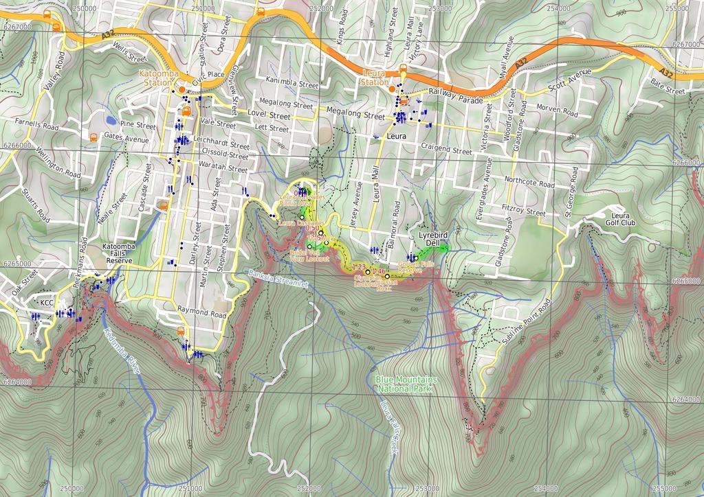
1 Leura Cascades to Gordon Falls Reserve 1 hr 15 mins 1.8 km One way Moderate track 200m From Leura Park to Gordon Falls Park, this diverse walk offers fantastic views of the Jamison Valley, as well as two great side trips down to some smaller waterfalls. Don't be fooled by their size - they are quite beautiful. Be sure to allow extra time for the side trips (especially Gordon Falls), in order to sit and reflect as the water cascades around you. 885m 94m Maps, text & images are copyright wildwalks.com Thanks to OSM, NASA and others for data used to generate some map layers. Blue Mountains National Park

2 Leura Cascades Picnic Area Leura Cascades Picnic area is a open picnic area beside Cliff Drive, with Leura Cascades Creek running through the middle. There are a number of small cascades in the park, along with toilets and picnic tables. There are a few information signs and maps of the area. The park is well remembered for the artificial caves and arches that have been built to provide shelter and a sense of place. A small road runs through the park, providing access and parking, and garbage facilities are provided. There is also plenty of shade from some large pine trees. Leura Cascades Leura Cascades is a lovely set of waterfalls with some bridges just below, allowing walkers to get up close to the creek. The area has a nice feel about it and is quite cool in summer. Much of the track near the cascades has handrails and the bridges are fenced. Allow some time to enjoy life among the cascades and fern trees in this valley. One bridge leads to a sandstone cave next to the pool and falls, a great place to enjoy the small section of canyon. The Rock The Rock is a small, partially-fenced lookout, about 10 metres from the Prince Henry Cliff Walk near Bridal Veil Falls. The old timber fence only partially covers the cliff line and the walk to the lookout can be slippery. The view from the lookout includes close-up views of the crowns of several trees. There is no view of Bridal Veil Falls, but the view does extend across to the cliffs at Bridal View Lookout. Bridal Veil View Lookout The Bridal Veil View is a small, fenced lookout at the base of a flight of stairs in the south-west corner of Leura. The lookout has a natural sandstone floor and provides superb, unobstructed view of the Bridal Veil Falls. The falls are about 150m away, and looking down from the top, the Bridal Veil likeness is apparent. The falls run most of the time, but are most spectacular after rain. Olympian Lookout Olympian Lookout is a fenced lookout, just off the Prince Henry Cliff Walk, near Olympian Pde in Leura. The lookout is on a sloped, natural sandstone surface and has some steps cut to help improve access. The lookout is right at the edge of the cliff and provides a great view across the Jamison Valley, out to Mount Solitary. The 'back' of the Three Sisters, and also Narrow Neck, are both visible on the right, and Sublime Point on the left. Before You walk Bushwalking is fun and a wonderful way to enjoy our natural places. Sometimes things go bad, with a bit of planning you can increase your chance of having an ejoyable and safer walk. Before setting off on your walk check 1) Weather Forecast (BOM Central Tablelands District) 2) Fire Dangers (Greater Sydney Region) ) Park Alerts (Blue Mountains National Park) 4) Research the walk to check your party has the skills, fitness and equipment required 5) Agree to stay as a group and not leave anyone to walk solo Think before you TREK The 'Think before you TREK' program developed by NSW Police & NPWS promotes the benefits of planning ahead for your bushwalking trip by using an easy to remember acronym: T R E K Take adequate supplies of food, water, navigation and first aid equipment. Register your planned route and tell friends and family when you expect to return. Emergency beacon (PLB's) should be carried on walks with significant gaps in mobile coverage (check terrain profile). Keep to your planned route and follow the map and walking trails. Topo Maps The maps provided on wildwalks are helpful, but there are times where you may need maps covering a broader area. Maps that cover this walk include; 1: Map Series:Six Foot Track 1: Map Series:8901S KATOOMBA 1: Map Series:890 KATOOMBA Grade This walk has been graded using the AS The overall grade of the walk is dertermined by the highest classification along the whole track. Length Time Quality of track Grade /6 Moderate track 1.8 km One way 1 hr 15 mins Formed track, with some branches and other obstacles (/6) Signs Directional signs along the way (/6) Experience Required Weather Infrastructure Some bushwalking experience recommended (/6) Weather generally has little impact on safety (1/6) Limited facilities, not all cliffs are fenced (/6)
3 Are you ready to have fun? Please ensure you and your group are well prepared and equipped for all possible hazards and delays. Check park closures, weather information and Fire Danger Rating before setting out. Optional side trips and alternate routes noted are not included in this walks overall grade, length or time estimate. Please allow extra time for resting and exploring areas of interest. The authors, staff and owners of wildwalks take care in preparing this information but will not accept responsibility for any inconvenience, loss or injury you may experience. Please take care, have fun - Happy Walking. Getting there You can get to Leura Cascades Picnic Area (gps: , ) by car or bus. Car: There is free parking available. You can get back from Gordon Falls Reserve (gps: , ) by car or bus. Car: There is free parking available. Find up to date and more information inlcuding; travel directions, weather, park closures and walker feedback at 0 Leura Cascades Picnic Area Leura Cascades Picnic area is a open picnic area beside Cliff Drive, with Leura Cascades Creek running through the middle. There are a number of small cascades in the park, along with toilets and picnic tables. There are a few information signs and maps of the area. The park is well remembered for the artificial caves and arches that have been built to provide shelter and a sense of place. A small road runs through the park, providing access and parking, and garbage facilities are provided. There is also plenty of shade from some large pine trees. 0 Leura Cascades Picnic Area (140 m mins) From cave-like shelters in Leura Cascades Picnic Area, this walk heads along the footpath, passing under the arch. Passing the toilet block, the path comes to the information board, from where the walk follows the 'Leura Cascades Track' sign down the steps. The path soon leads to a small stone wall with a view of some cascades and Chelmsford Bridge. From the view of Chelmsford Bridge, this walk follows track downhill, keeping the handrail and creek to the left, soon coming to an intersection with 'Prince Henry Cliff Walk' just before a footbridge. Continue straight: From the intersection, this walk follows the 'Leura Cascades' sign across the footbridge to a 'Y' intersection Optional sidetrip to Leura Cascades (170 m 4 mins) Continue straight: From the intersection, this walk follows the 'Leura Cascades' sign down the steps, keeping the handrail and creek to the right. After a short while, the walk heads along a timber platform and down some stairs to a rock platform, with great views of some cascades. From these cascades, the walk heads down more stairs, coming to an intersection just before two bridges, with great views of Leura Cascades. At the end of this side trip, retrace your steps back to the main walk then Turn sharp right Leura Cascades Leura Cascades is a lovely set of waterfalls with some bridges just below, allowing walkers to get up close to the creek. The area has a nice feel about it and is quite cool in summer. Much of the track near the cascades has handrails and the bridges are fenced. Allow some time to enjoy life among the cascades and fern trees in this valley. One bridge leads to a sandstone cave next to the pool and falls, a great place to enjoy the small section of canyon Int of Prince Henry Cliff Walk and Leura Cascades (60 m 7 mins) Veer left: From the intersection, this walk follows the 'Prince Henry Cliff Walk To Gordon Falls' sign up the timber steps. The walk continues along the bush track that steadily climbs to the top of the gentle hill, where it comes to an intersection with the Cliff Drive bush track. Continue straight: From the intersection, the walk follows the bush track heading around the side of the hill, winding through the bush until it comes to the intersection of the short bush track to Cliff Drive. Veer right: From the intersection, this walk follows the bush track winding around the valley down to the right for a short while, before coming to 'The Rock' lookout just off the track on the right. 0.5 The Rock The Rock is a small, partially-fenced lookout, about 10 metres from the Prince Henry Cliff Walk near Bridal Veil Falls. The old timber fence only partially covers the cliff line and the walk to the lookout can be slippery. The view from the lookout includes close-up views of the crowns of several trees. There is no view of Bridal Veil Falls, but the view does extend across to the cliffs at Bridal View Lookout. 0.5 The Rock (110 m mins) Turn left: From the lookout, this walk follows the bush track winding around the valley, down to the right, heading under a large rock overhang and continuing steadily up the long rocky hill to the signposted intersection of the Bridal View Lookout. 0.6 Optional sidetrip to Bridal Veil View lookout (200 m 4 mins) Veer right: From the intersection, the walk follows the 'Bridal View Lookout' sign along the track, heading out towards the cliffs for a short while before winding down a set of metal stairs to the signposted 'Bridal Veil View' lookout. At the end of this side trip, retrace your steps back to the main walk then Veer right. 0.6 Bridal Veil View Lookout The Bridal Veil View is a small, fenced lookout at the base of a flight of stairs in the south-west corner of Leura. The lookout has a natural sandstone floor and provides superb, unobstructed view of the Bridal Veil Falls. The falls are about 150m away, and looking down from the top, the Bridal Veil likeness is apparent. The falls run most of the time, but are most spectacular after rain. 0.6 Int of Prince Henry Cliff Walk and Bridal Veil Loo (60 m 19 mins) Turn left: From the intersection, this walk follows the 'Gordon Falls' sign along the bush track, winding through the dense bush for a short while before gradually climbing up a gentle hill to the signposted intersection of the Tarpeian Rock track. Continue straight: From the intersection, the walk follows the 'Gordon Falls' sign down the wooden steps and along the track. Notice the environment change to rainforest as the track winds around the valley down to the right. The walk follows the base of some tall rock overhangs, then climbs up a long set of wooden steps that continue on to rock steps, coming to 'Olympian Rock' lookout. 1.2 Olympian Lookout Olympian Lookout is a fenced lookout, just off the Prince Henry Cliff Walk, near Olympian Pde in Leura. The lookout is on a sloped, natural sandstone surface and has some steps cut to help improve access. The lookout is right at the edge of the cliff and provides a great view across the Jamison Valley, out to Mount Solitary. The 'back' of the Three Sisters, and also Narrow Neck, are both visible on the right, and Sublime Point on the left. 1.2 Olympian Lookout (20 m 1 mins) Continue straight: From the lookout, this walk follows the bush track past the "Welcome to the Blue Mountains National Park" sign, keeping the valley down the hill to the right as it winds through the bush. The walk comes to a lookout just before the Buttenshaw Bridge, which it then crosses, continuing up the steps to the Elysian Rock Lookout on the other side Elysian Rock Elysian Rock is a fenced, small, narrow lookout on a rock buttress. The floor is mostly uneven, natural sandstone and there is a bench seat with no shade. The lookout is right at the edge of the cliff and gives a great view straight across the Jamison Valley and out to Mount Solitary. Narrow Neck and the 'back' of the Three Sisters are visible on the right-hand side, and Sublime Point on the left. The lookout is along the Prince Henry Cliff Walk, just west of a concrete bridge spanning a chasm and near the end of Elysian Place, Leura Elysian Lookout (60 m 10 mins) Veer right: From Elysian Lookout, keeping the valley down to the right, this walk follows the bush track winding through the dense scrublike forest as it heads up a few wooden steps onto a small platform and continues up the hill to the top, at the intersection of the Gordon Falls Lookout track. Continue straight: From the intersection, this walk follows the flat track winding through the thick bush for a short while to the back of the Gordon Falls Reserve picnic area. 1.8 Gorden Falls Reserve Gordon Falls Reserve is just off Lone Pine Ave near the intersection with Olympian Pde, Leura. The park has car parking, electric BBQ's, toilets, garbage disposal, children's play equipment, picnic tables and bench seats. The park has plenty of open area and some shaded spots. There are a number of artificial cave shelters, with picnic tables inside. 1.8 Optional sidetrip to Pool of Siloam (00 m 11 mins) Continue straight: From the lower side of Gordon Falls Reserve, this walk follows the 'Pool of Siloam' track sign into the bush, down the gentle hill (passing a track on the left). The walk passes some interesting information signs on local flora and fauna as the track becomes steeper. Continuing down the stairs, the track leads to a rock wall and a handrail. The walk heads along the base of this cliff, under a small waterfall and comes to a three-way intersection (with signposts down to the right and on the other side). Turn right: From the intersection, this walk follow the 'Pool of Siloam' sign down the steps. The track passes under a small overhang then crosses Gordon Creek on a footbridge in front of the lovely falls and the Pool of Siloam. At the end of this side trip, retrace your steps back to the main walk then Turn sharp right.
4
5 Powered by TCPDF ( Summary navigation sheet for the Leura Cascades to Gordon Falls Reserve km From Up/Dwn Length Initial directions (Use full tracknotes and maps for more detail) Start Leura Cascades Picnic Area , (GR Katoomba, ) m mins From cave-like shelters in Leura Cascades Picnic Area, this walk heads along the footpath, passing under the arch Int of Prince Henry Cliff Walk and Leura Cascades Round Walk (NE) ,150.2 (GR Katoomba, ) m 4 mins Optional sidetrip to Leura Cascades. Continue straight: From the intersection, this walk follows the 'Leura Cascades' sign down the steps, keeping the handrail and creek to the right Int of Prince Henry Cliff Walk and Leura Cascades Round Walk (NE) ,150.2 (GR Katoomba, ) m 7 mins Veer left: From the intersection, this walk follows the 'Prince Henry Cliff Walk To Gordon Falls' sign up the timber steps The Rock , (GR Katoomba, ) m mins Turn left: From the lookout, this walk follows the bush track winding around the valley, down to the right, heading under a large rock overhang and continuing steadily up the long rocky hill to the signposted inters Int of Prince Henry Cliff Walk and Bridal Veil Lookout Track -.726, (GR Katoomba, 52165) m 4 mins Optional sidetrip to Bridal Veil View lookout. Veer right: From the intersection, the walk follows the 'Bridal View Lookout' sign along the track, heading out towards the cliffs for a short while before winding down a set of metal stairs to the signposted 'Brida Int of Prince Henry Cliff Walk and Bridal Veil Lookout Track -.726, (GR Katoomba, 52165) m 19 mins Turn left: From the intersection, this walk follows the 'Gordon Falls' sign along the bush track, winding through the dense bush for a short while before gradually climbing up a gentle hill to the signposted interse Olympian Lookout , (GR Katoomba, ) m 1 mins Continue straight: From the lookout, this walk follows the bush track past the "Welcome to the Blue Mountains National Park" sign, keeping the valley down the hill to the right as it winds through the bush Elysian Lookout , (GR Katoomba, ) m 10 mins Veer right: From Elysian Lookout, keeping the valley down to the right, this walk follows the bush track winding through the dense scrub-like forest as it heads up a few wooden steps onto a small platform and contin Gordon Falls Reserve , (GR Katoomba, ) m 11 mins Optional sidetrip to Pool of Siloam. Continue straight: From the lower side of Gordon Falls Reserve, this walk follows the 'Pool of Siloam' track sign into the bush, down the gentle hill (passing a track on the left).
Nature Track. 900m. 789m. 2 hrs 3.1 km Circuit. Hard track 238m. Blue Mountains National Park
 Nature Track 2 hrs 3.1 km Circuit Hard track 238m Largely following the ridges around the top edge of Wentworth Falls, this track is incredibly beautiful. After taking in the great views at Edinburgh Castle
Leura to Katoomba via Dardanelles Pass
 Leura to Katoomba via Dardanelles Pass 4 hrs 6.6 km One way Hard track 697m With approximately equal parts cliff-walk and forest track, this track truly shows what the cliff edges of the Jamison Valley
Victoria Falls Lookout to Blue Gum Forest
 Victoria Falls Lookout to Blue Gum Forest 8 hrs Experienced only 13.8 km One way 5 112m This long day-walk follows a remote track down from Victoria Falls lookout, passing the waterfall, and into the Grose
The Prince Henry Cliff Walk
 The Prince Henry Cliff Walk 3 hrs 30 mins 6.8 km One way Moderate track 3 575m Going from Katoomba to Leura, this walk covers the top of the cliff line and most of the major lookouts. With brilliant vistas
National Pass. 893m. 665m. 3 hrs 30 mins 4.6 km Circuit. Hard track 773m. Blue Mountains National Park
 National Pass 3 hrs 3 mins 4.6 km Circuit Hard track 773m 4 This walk offers fantastic views of the Jamison Valley and the surrounding cliffs. Take time to explore the historic and very scenic ledge halfway
Congewai Track Head (East) to Watagan Headquarters
 to Watagan Headquarters") Congewai Track Head (East) to Watagan Headquarters 7 hrs Hard track 17.2 km One way 4 973m This full day walk starts from the Congewai valley trackhead (east) and follows the Great North Walk up into the
Congewai Track Head (East) to Watagan Headquarters 7 hrs Hard track 17.2 km One way 4 973m This full day walk starts from the Congewai valley trackhead (east) and follows the Great North Walk up into the
Abbotts Falls Walking Track
 Abbotts Falls Walking Track 3 hrs 7.3 km Circuit Hard track 329m This circuit takes you through both dry and moist forest, using a combination of walking trails and wider tracks. The side trip to the dammed
Wentworth Pass. 893m. 535m. 4 hrs. Hard track 5.1 km Circuit. 692m
 Wentworth Pass 4 hrs Hard track 5.1 km Circuit 4 692m This walk offers a great way to explore the magical, upper section of the Valley of the Waters. The walk starts and finishes at Conservation Hut, which
Staples Lookout to Mt Wondabyne loop
 Staples Lookout to Mt Wondabyne loop 4 hrs 3 mins 1.8 km Circuit Hard track 337m This walk starts and finishes at Staples Lookout, on Woy Woy Rd. The walk follows sections of the Great North Walk around
Erskine Creek via Pisgah Rock and Jack Evans
 Erskine Creek via Pisgah Rock and Jack Evans 4 hrs 30 mins 7.1 km Circuit Very experienced only 6 421m This walk visits some great lookouts and explores the lower section of Erskine Creek. Most of the
Scenic Railway to Ruined Castle
 Scenic Railway to Ruined Castle 7 hrs 30 mins 12.4 km Return Hard track 4 963m This is a very popular, full day walk, in the Katoomba Area, offering great views of the valley. The walk follows the edge
Merritts Traverse. 1928m
 Merritts Traverse 3 hrs Hard track 5.8 km Circuit 4 167m This walk starts with a scenic journey to the top of the hill on the chairlift. Starting along Merritts Nature walk, this walk soon detours down
Girrakool to Wondabyne station
 Girrakool to Wondabyne station 4 hrs Hard track 9.5 km One way 4 438m This walk starts from the Girrakool picnic area and winds south, through the Brisbane Waters National Park. The walk crosses some long
Mt Kuring-gai Track to Berowra station
 Mt Kuring-gai Track to Berowra station 4 hrs 15 mins 9.7 km One way Hard track 4 553m This walk explores three valleys, with great displays of wild flowers in spring, and some nice sandstone overhangs.
Guthega to Mt Twynam. 2183m. 1583m. 6 hrs 45 mins 14.8 km Return. Experienced only. 913m
 Guthega to Mt Twynam 6 hrs 45 mins 14.8 km Return Experienced only 5 913m This walk starts from Guthega and makes its way along the Snowy River to the Illawong Lodge, via the Blue Cow Creek flying fox.
Berowra Waters to Cowan Station
 Berowra Waters to Cowan Station 3 hrs 30 mins 7.2 km One way Hard track 597m This is a hilly walk out of the beautiful Berowra Waters valley to Cowan Station. There are many wide views across Berowra Creek
Dadder Cave and Jack Evans track
 Dadder Cave and Jack Evans track 2 Days 10.3 km Circuit Very experienced only 535m This fairly short overnight walk is a great way to explore Erskine Creek. The walking along Erskine creek is mostly off
Victoria Falls to Blackheath Station
 Victoria Falls to Blackheath Station 2 Days Experienced only 22.2 km One way 5 1561m This is a fantastic overnight walk with a sleep in Acacia Flats camping area. The Grose Valley, with its views of the
Victoria Falls and Grose Valley to Blackheath Station
 Victoria Falls and Grose Valley to Blackheath Station 3 Days Experienced only 22.5 km One way 5 158m This walk explores a fantastic section of the Grose Valley. Starting above Victoria Falls, the walk
Girrakool to Wondabyne station via Pindar caves
 Girrakool to Wondabyne station via Pindar caves 7 hrs 30 mins 18.1 km One way Experienced only 5 741m This walk starts from the Girrakool picnic area and winds south, following Piles creek into the Brisbane
Crosslands to Berowra Waters return
 Crosslands to Berowra Waters return 6 hrs Hard track 13.7 km Return 4 1005m This return walk starts from the Crosslands Reserve and follows the Great North Walk along Berowra creek. The walk includes some
Berowra to Cowan via Berowra Waters
 Berowra to Cowan via Berowra Waters 6 hrs Hard track 12.9 km One way 4 884m With train station at each end this walk explores the ridges and valleys around Berowra Waters. There are plenty of excellent
Gibberagong Track. 169m
 Gibberagong Track 2 hrs 30 mins 6.5 km One way Hard track 4 180m Starting in suburban Wahroonga, this wellmaintained track follows Cockle Creek down to Bobbin Head in the Ku-ring-gai Chase National Park.
Blackheath to Blue Gum loop
 Blackheath to Blue Gum loop 2 Days Hard track 24.1 km Circuit 4 1335m This walk is great for fit people getting into overnight walking, with its fantastic scenery and nostalgia as a classic overnighter.
Crosslands to Cowan. 220m
 Crosslands to Cowan 7 hrs 30 mins 14 km One way Hard track 4 1103m This section of the Great North Walk starts from the Crosslands camping area and winds north alongside Berowra creek, passing through
Jerusalem Bay Track (Cowan to Brooklyn)
") Jerusalem Bay Track (Cowan to Brooklyn) 5 hrs 30 mins 13.4 km One way Hard track 4 654m This Cowan to Brooklyn Station walk is a popular section of the Great North Walk, with scenery ranging from foreshore
Jerusalem Bay Track (Cowan to Brooklyn) 5 hrs 30 mins 13.4 km One way Hard track 4 654m This Cowan to Brooklyn Station walk is a popular section of the Great North Walk, with scenery ranging from foreshore
Lady Carrington Drive
 Lady Carrington Drive 3 hrs 45 mins 9.7 km One way Moderate track 3 266m This walk follows the historic Lady Carrington Drive alongside the Hacking River. The old road is closed to traffic and provides
Hornsby station to Crosslands
 Hornsby station to Crosslands 6 hrs 45 mins 16.1 km One way Hard track 4 938m This section of the Great North Walk starts from Hornsby train station and winds down along the Blue Gum Walk into Fishponds.
Main Range Walk - Charlotte Pass to Mount Kosciuszko
 Main Range Walk - Charlotte Pass to Mount Kosciuszko 9 hrs Hard track 21.9 km Circuit 4 920m This full day walk explores some of the greatest alpine country on offer in NSW. The walk grants views of Blue,
Patonga to Staples Lookout
 Patonga to Staples Lookout 6 hrs 3 mins 17 km One way Hard track 4 72m This great walk explores much of the main ridge ridge running through Brisbane Water National Park. The walk visits a number of great
Main Range Track - Loop from Charlotte Pass camping near Mt Townsend
 Main Range Track - Loop from Charlotte Pass camping near Mt Townsend 2 Days Experienced only 27.7 km Circuit 5 1260m This great overnight walk starts from Charlotte Pass and provides access to some of
Katoomba to Wentworth Falls via the Jamison Valley
 Katoomba to Wentworth Falls via the Jamison Valley 2 Days Experienced only 29.2 km One way 5 2135m This is the two day version of this popular and challenging walk. This walk passes popular sights including
Berowra to Hornsby. 9 hrs 18 mins 22.6 km One way. Hard track. 1423m
 Berowra to Hornsby 9 hrs 18 mins 22.6 km One way Hard track 4 1423m One of the longer day walks in Berowra Valley National Park, this walk mostly follows Berowra Creek along the Great North Walk. Excellent
Patonga to Wondabyne station via Mt Wondabyne
 Patonga to Wondabyne station via Mt Wondabyne 7 hrs 3 mins 19.5 km One way Hard track 4 861m This walk explores some grand views, pleasant cascades, varied bushland and remote areas of Brisbane Waters
Somersby to Yarramalong via Stringy Bark Point
 Somersby to Yarramalong via Stringy Bark Point 2 Days Hard track 26.7 km One way 4 1201m This section of the Great North Walk starts form the Somersby General Store and follows the Great North Walk north
Guthega to Thredbo camping overnight at Wilkensons Creek
 Guthega to Thredbo camping overnight at Wilkensons Creek 2 Days Experienced only 25.8 km One way 5 1364m This great overnight walk explores the Kosciusko National Park between Guthega and Thredbo, visiting
Victoria Falls and Grose Valley to Blackheath Station
 This walk explores a fantastic section of the Grose Valley. Starting above Victoria Falls, the walk explores the cascades before dropping into the valley for the first nights rest at Burra Korain campsite.
Patonga to Wondabyne station via Pindar Caves overnight
 Patonga to Wondabyne station via Pindar Caves overnight 2 Days Experienced only 28.1 km One way 5 1164m This overnight hike starts from Patonga beach and winds along a section of the Great North Walk,
Wondabyne station to Somersby Store
 Wondabyne station to Somersby Store 10 hrs Hard track 26.2 km One way 4 1164m This walk, following a section of the Great North Walk, starts from the Wondabyne train station and winds north, into the Brisbane
Somersby to the Basin Campsite
 Somersby to the Basin Campsite 3 Days Hard track 47.4 km One way 4 2032m This three day walk starts at the Somersby General Store and follows the Great North Walk, heading north, into the the Jilliby State
Crosslands to Brooklyn
 Crosslands to Brooklyn 2 Days Hard track 27.4 km One way 4 1757m From the Crosslands Reserve, this walk heads along the Great North Walk via Berowra Waters, Cowan, Jerusalem Bay and onto Brooklyn. This
Main Range Circuit from Guthega
 Main Range Circuit from Guthega 4 Days Experienced only 45 km Circuit 5 2317m This four day walk explores the Kosciuszko National Park, covering many of the key features of the park between Guthega and
Cowan to Wondabyne station via Patonga rest area
 Cowan to Wondabyne station via Patonga rest area 2 Days Hard track 33.4 km One way 4 1523m This section of the Great North Walk starts from Cowan train station and wanders past the majestic Jerusalem Bay
Gordon to Hornsby (overnight at Scout camp)
") Gordon to Hornsby (overnight at Scout camp) 2 Days Hard track 25.8 km One way 4 125m This overnight walk starts from Gordon train station and winds through bush filled valleys to Hornsby station. From
Gordon to Hornsby (overnight at Scout camp) 2 Days Hard track 25.8 km One way 4 125m This overnight walk starts from Gordon train station and winds through bush filled valleys to Hornsby station. From
Thornleigh to Cowan. 2 Days. Hard track 35.9 km One way. 2337m
 Thornleigh to Cowan 2 Days Hard track 35.9 km One way 4 2337m Following the Great North Walk and Berowra Creek through Berowra Valley Regional Park, this walk cuts straight through the length of the Park.
Western Commission Track to Dubbo Gully
 This two day walk follows a series of historic roads along clear and wide management trails. This walk explores the great views from Western Commission Track, the sandstone handicraft on the Old Great
DAY 1: Emu Plains to Glenbrook Wednesday, January 2, 2019
 DAY 1: Emu Plains to Glenbrook Wednesday, January 2, 2019 Some sun: 34 C / 21 C 3mm Meeting time: 8.00am @ Our Lady of the Way Catholic Church, Emu Plains [15 Troy Street, Emu Plains; altitude: 32m] Mass:
Out and about at Geehi
 Geehi Geehi Flats is a large area of flat floodplain on the banks of the Swampy Plains River. Located within Kosciuszko National Park, it is home to a popular campsite in summer for people wanting to enjoy
GOLDEN EARS PROVINCIAL PARK
 GOLDEN EARS PROVINCIAL PARK Trail Information as of October 10 th 2015 Do not underestimate the mountainous wilderness of Golden Ears Provincial Park. The combination of rugged terrain and rapidly changing
Illawarra Escarpment State Conservation Area Walking Tracks
 Illawarra Escarpment State Conservation Area Walking Tracks NPWS Illawarra Area Office Ground Floor, Government Office Block 84 Crown Street Wollongong NSW 2500 02 4223 3000 (Mon-Fri) Royal National Park
Leaden Boot Challenge ROUTE INSTRUCTIONS
 Leaden Boot Challenge ROUTE INSTRUCTIONS Section 1 Alstonefield to Ilam From the village hall car park turn R then L and pass through the village keeping to the R to enter Church Street. Pass the Church
Sponsored by. statestreet.com
 /STATESTREETISLANDWALK #ISLANDWALKJSY Sponsored by statestreet.com Important Information If you forget everything else PLEASE remember the following.» Remember to check OUT of every checkpoint» If you
Tiger Mountain State Forest:
 98 60 hikes within 60 miles: SEATTLE 20 Tiger Mountain State Forest: West Tiger Mountain Three Loop i KEY AT-A-GLANCE INFORMATION Length: 5.1 miles round-trip Configuration: Loop Difficulty: Moderate difficult
Little Grand Canyon near Pomona, Illinois
 Little Grand Canyon near Pomona, Illinois Below: View of the trail and the terrain created using the Map My Hike app Below: Summary of the hike created using the Map My Hike app Presented by: Jennifer
CWMGIEDD FROM ABERCRAVE
 Abercrave to Cwmgiedd Walk Page 1 Starting from The Abercrave Inn. Grid Ref: SN 824128 From the Abercrave Inn, an 11.3km (7 miles) walk to the foothills of the Cribarth Mountain, then through forest to
DAY 1: Circular Quay to Greenwich Wharf
 DAY 1: Circular Quay to Greenwich Wharf Total Distance: 14km Time: Approximately 5 hours Walk Notes in Six Sections Section Name Length Time 1:1 Circular Quay to Milsons Point Station 2.5km 50mins 1:2
The Mendip Way. Route Directions and Maps Uphill to Wells
 The Mendip Way Route Directions and Maps Uphill to Wells Website: www.mendiphillsaonb.org.uk Email: mendip@mendiphillsaonb.org.uk Facebook & Twitter: @MendipHillsAONB Phone: 01761462338 1 Uphill to Loxton
COLOUR G U I D E. Sydney to Newcastle: Australia s most accessible long-distance walk
 COLOUR G U I D E Sydney to Newcastle: Australia s most accessible long-distance walk Woodslane Press Pty Ltd Unit 7/5 Vuko Place Warriewood, NSW 2102 Australia Email: info@woodslane.com.au Tel: (02)
Leaden Boot Challenge 2016 ROUTE INSTRUCTIONS
 Leaden Boot Challenge 2016 ROUTE INSTRUCTIONS Section 1 Alstonefield to Ilam (CP2) From the village hall car park turn R then L and pass through the village keeping to the R to enter Church Street. Pass
Printed in China by Designed by Coral Lee Main cover image: Broken Bay
 Woodslane Press Pty Ltd Unit 7/5 Vuko Place Warriewood, NSW 2102 Australia Email: info@woodslane.com.au Tel: (02) 9970 5111 Fax: (02) 9970 5002 http://travelandoutdoor.bookcentre.com.au First published
Beautiful Walks from the Blue Ball Inn
 Walk No. 5 RIVER VALLEYS AND MOOR Countisbury, Watersmeet, Hillsford Bridge, Cheriton, Shilstone Hill, Rockford and Chiselcombe. 8.5 MILES APPROX. Walking time four and a half hours approx. OS 1;25,000
Aira Force & Ullswater Access Statement
 Aira Force & Ullswater Access Statement Aira Force, Watermillock, Penrith, CA11 0JS T: 017684 82067 E: ullswater@nationaltrust.org.uk Section 1: Aira Force Section 2: Ullswater Countryside Section 1: Aira
TREK THE ROCKIES ABOUT THE CHALLENGE TREK THE ROCKIES FOR HIGHLAND HOSPICE CANADA TREK DEMANDING
 TREK THE ROCKIES CANADA TREK DEMANDING ABOUT THE CHALLENGE The Canadian Rockies are justifiably world-famous for their magnificent scenery: the combination of impressive, jagged mountains, bright turquoise
BISHOPSTONE CIRCULAR WALK
 BISHOPSTONE CIRCULAR WALK 4½ miles (7¼ km) - allow 2 hours (see maps on final pages) Introduction This walk is within the North Wessex Downs Area of Outstanding Natural Beauty and starts from the small,
Hindhead, Keffolds Copse and Gibbet Hill
 point your feet on a new path, Keffolds Copse and Gibbet Hill Distance: 6 km=4 miles Region: Surrey Author: Schwebefuss Refreshments: Punch Bowl Café moderate walking Date written: 14-apr-2015 Last update:
Lake Wissota Access Locations within the LaFayette Township. By Chad Martin
 Lake Wissota Access Locations within the LaFayette Township By Chad Martin Anson/ Wissota Access Point # 1 Road: 195 th St. Associated Fire Numbers: 13294 Defining Characteristics: Forested from road
Trail Phasing Plan. Note: Trails in the Clear Creek Canyon area (Segments will be finalized in the future to minimize wildlife impacts
 Note: Trails in the Clear Creek Canyon area (Segments 2 5 and a future JCOS connection) will be finalized in the future to minimize wildlife impacts Trail Phasing Plan P Parking 3 Easy Trail Intermediate
Fetcham Downs and Bocketts Farm A magical teashop walk
 point your feet on a new path Fetcham Downs and Bocketts Farm A magical teashop walk Distance: 3 km=2 miles or 4 km=2½ miles Region: Surrey Author: Fusszweig Refreshments: Bocketts Farm easy walking Date
Asheville & WNC Hikes
 Asheville & WNC Hikes Amazingly, we have 3,000+ miles of free public hiking trails near Asheville, including 1,600 miles in the Pisgah and Nantahala National Forests, 850 miles in Great Smokey Mountains
Slad over to Pitchcombe and back
 The walk climbs up from Slad over Wickridge Hill, descends to near Pitchcombe, then climbs back over Wickridge hill and round the back of Slad. Page 1 Start Point: SO 8718 0732 The Woolpack, Slad Length:
The Rocher du Long Boyau and the Gorges du Houx
 A walk proposed by Netra From the Ermitage de Franchard, this is a very varied hike which will take you past old sandstone quarries, the Gorges du Houx and the charming Mare aux Pigeons. On the route are
Griffith Park Trail Run Trail Guide Click for
 The Griffith Park Trail Run by Hike- LosAngeles.com Griffith Park Trail Run Trail Guide Click for downloadable cell phone guide and map from EveryTrail. DISTANCE: 4.55 Miles ELEVATION: 1280' ELEVATION
Bewl Water & the High Weald
 1 Bewl Water & the High Weald Stonegate station - Stonegate - Wallcrouch - Newbarn - Cousley Wood - Wood's Green - Wadhurst station Length: 9 ½ miles (15.3km) Underfoot: Large portions of this path are
FROM MEGISTI LAVRA AND SKITI TIMIOU PRODOMOU TO SKITI AGIA ANNA
 FOOTPATHS OF THE HOLY MOUNTAIN FROM MEGISTI LAVRA AND SKITI TIMIOU PRODOMOU TO SKITI AGIA ANNA Distance: From Megisti Lavra 12.7 km, From Timiou Prodromou 10.4 km Journey Time: 5-6 hours The Friends of
Singleton and the South Downs
 point your feet on a new path Singleton and the South Downs Distance: 13½ km=8½ miles easy walking with a few steeper sections Region: West Sussex Author: Hautboy Refreshments: Singleton, Hill Barn Date
Mt Wilson Mt Irvine Bushwalking Group
 Mt Wilson Mt Irvine Bushwalking Group Volume 26 Issue 6 & 7 June & July 2016 LEURA CASCADES TO LYREBIRD DELL OUR MAY WALK LEURA CASCADES, GORDON FALLS, POOL OF SILOAM and LYREBIRD DELL at LEURA Friday
Charnley Explorer June 24 - July 15, 2018 Bachsten Creek and the Charnley River. Second draft: 14 November 2017
 Charnley Explorer June 24 - July 15, 2018 Bachsten Creek and the Charnley River. Second draft: 14 November 2017 The best part of the original section one is now part of out Gibb Road Gorges trip. The dates
Ardingly Lake, Ouse Valley, Borde Hill
 point your feet on a new path Ardingly Lake, Ouse Valley, Borde Hill Distance: 14 km=9 miles or 12½ km=8 miles Region: West Sussex Author: Hautboy Refreshments: Borde Hill Map: Explorer 135 (Ashdown Forest)
Discover. Ashhurst Domain. Nature s Playground
 Discover Ashhurst Domain Nature s Playground Discover Step back into New Zealand, Aotearoa, of generations long gone. Discover lush natural surrounds echoing with rich birdsong in one of the Manawatu s
Darwin s gigantic blunder
 Trail Darwin s gigantic blunder Explore how ice shaped the landscape and why Charles Darwin made a nice mess of Glen Roy Time: 1hr 10 mins Distance: 2 miles Landscape: rural At Glen Roy a curious feature
GIFFORD PINCHOT NATIONAL FOREST
 GIFFORD PINCHOT NATIONAL FOREST 9341 Wright Meadow 93 Spencer Meadow Spencer Butte 4247' 30 30A 19 24 80 31C Lewis River Lower Falls 5 Quartz Creek 90 Taidnapam Falls Upper Falls 31 Spencer Peak 3861'
Bonaqua Mountain Hardware Action Sprint 2013 Discovery Bay,Lantau The Course Route
 Bonaqua Mountain Hardware Action Sprint 2013 Discovery Bay,Lantau The Course Route The start is inside the Discovery Bay plaza and leads out to the main sandy beach where you will run to the end of the
Prince Regent National Park
 Prince Regent National Park 23 rd June- 14 th July 2019 Garimbu Creek, Moran and Roe River Area Notes written by Cassie Newnes This area has something for everyone, magnificent scenery, stunning waterfalls,
BRR Leg 1 (3.9 miles, Easy)
") BRR Leg 1 (3.9 miles, Easy) Min 3901 Max 4919 Ascent +21 Descent -1031 0.0 Start (Grayson Highlands State Park Visitor Center) 3.9 Grayson Highlands State Park Office & Gate, on R (EZ 1) Leg Notes: Minimal
BRR Leg 1 (3.9 miles, Easy) Min 3901 Max 4919 Ascent +21 Descent -1031 0.0 Start (Grayson Highlands State Park Visitor Center) 3.9 Grayson Highlands State Park Office & Gate, on R (EZ 1) Leg Notes: Minimal
Hadleigh Castle and Chalkwell Oaze
 1 Hadleigh Castle and Chalkwell Oaze Benfleet station Hadleigh Park Hadleigh Castle Leigh-on-Sea Chalkwell station A short stroll through the lush woods of Hadleigh Park high above the Thames-side marshes,
Self-Guided Walk Malham, Gordale and Malham Tarn
 Self-Guided Walk Malham, Gordale and Malham Tarn Combine all the major geological attractions of Malham in this walk and hopefully leave enough time to enjoy the cafes, pubs and shops of the village. Malham
beach. Make the ford and follow the trail out to the junction with Red Creek Tr in an open grassy area.
 Description: This is a moderate to slightly strenuous 22.8 mile backpack (add 2.6 miles if you do the packless out and back to the Lion s Head) that will have you exploring nearly every thing that is The
Hiking Las Vegas.com
 Hike: Mt. Wilson via First Creek Canyon route Trailhead: First Creek marked Distance: 10 miles up and back Elevation gain: 3,400 feet Elevation of Peak: 7,070 feet Time: 7 to 9 hours (up and back) Difficulty:
C E N T R A L C A T S K I L L S
 120 C E N T R A L C A T S K I L L S Central Catskills Once out of the southern parts of the Catskills, the Long Path enters the more well traveled and civilized regions. The trail joins the Devil s Path,
FROM JUTA TO ROSHKA via Chaukhi pass
 FROM JUTA TO ROSHKA via Chaukhi pass Duration: 1-2 days The hike can take one or two days, depending on how you plan it. I will focus on the 1-day version of the trek which takes 8-9 hours and starts in
Hiking Las Vegas.com
 Hike: Juniper Peak up and back Trailhead: Oak Creek Canyon marked Distance: 5.5 miles round trip Elevation gain: 2,200 feet Elevation peak: 6,109 feet Time: 4 to 5 hours - Up and back Difficulty: 3 Danger
Pontfadog. Walk A. Walk A
 Walk A A Bird s eye view of the village 2km. (1 1 /2 miles); height gain 45m. (150ft) about 45 minutes. Six minutes walk along the main road towards Glyn Ceiriog reach a signpost to Llwynmawr. Take the
White Horse. For your own safety warn the MCA Coastguard Helicopter (01305) They have been known to low fly in this area
 They have been known to low fly in this area") Site Code 2.078 OS Grid Ref: SY 715 844 (Map 194) GPS: N50:39.514 Owned and farmed by: Nearest Phone: Casualty Units: W2:24:273 P & J Critchell Farm Osmington 01305 834314 Broadmayne or Sutton Poyntz County
Site Code 2.078 OS Grid Ref: SY 715 844 (Map 194) GPS: N50:39.514 Owned and farmed by: Nearest Phone: Casualty Units: W2:24:273 P & J Critchell Farm Osmington 01305 834314 Broadmayne or Sutton Poyntz County
BRR Leg 1 (4.0 miles, Easy)
") BRR Leg 1 (4.0 miles, Easy) Min 3881 Max 4948 Ascent +36 Descent -1027 0.0 Start (Grayson Highlands State Park Visitor Center) 4.0 Grayson Highlands State Park Office & Gate, on L (EZ 1) Leg Notes: Minimal
BRR Leg 1 (4.0 miles, Easy) Min 3881 Max 4948 Ascent +36 Descent -1027 0.0 Start (Grayson Highlands State Park Visitor Center) 4.0 Grayson Highlands State Park Office & Gate, on L (EZ 1) Leg Notes: Minimal
Walks in Sydney Stephen Lord
 Walks in Sydney Stephen Lord SYDNEY HARBOUR N.P.: MANLY TO THE SPIT The foreshore walking track from Manly to the Spit passes through sections of Sydney Harbour National Park and offers an opportunity
Approximate distance: 7.5 miles For this walk we ve included OS grid references should you wish to use them.
 Approximate distance: 7.5 miles For this walk we ve included OS grid references should you wish to use them. 6 5 7 8 4 1 2 Start End N 3 W E S Reproduced by permission of Ordnance Survey on behalf of HMSO.
Kakadu Highlights No. 9: September 23 - October 6, 2018
 Kakadu Highlights No. 9: September 23 - October 6, 2018 Section 1: Barramundi Creek: September 23-26 We begin with a four to six hour, 350 kilometre drive from Darwin. The last 45 kilometres is on a 4WD
Magoebaskloof Hiking Trail
 Magoebaskloof Hiking Trail Location The Magoebaskloof Hiking Trail is near the town of Tzaneen in the Limpopo Province. How to get there To Woodbush Hut. From Gauteng, take the N1 North towards Polokwane
Trail Beginning Elevation: 7553 ft The Poison Creek Trailhead is located at the end of National Forest Road 646E (NF-646E).
.") West Mountain Trails Poison Creek Trail #134 Length: 2.9 miles (4.7 km) Difficulty Horseback: A good trail for the first time west mountain rider, some steep sections Hiking: Most Difficult USGS Maps:
West Mountain Trails Poison Creek Trail #134 Length: 2.9 miles (4.7 km) Difficulty Horseback: A good trail for the first time west mountain rider, some steep sections Hiking: Most Difficult USGS Maps:
TUPPER DESIGNATED ACCESS ROUTE
 TUPPER DESIGNATED ACCESS ROUTE 1 FOR ACCESS/EGRESS TO CONNAUGHT, LOOKOUT, STONE ARCH, PORTAL PATHS AND TUPPER TRAVERSE EGRESS Length: 2.6km Vertical Gain: +162m / -83m (Values are for access. For egress,