Somersby to the Basin Campsite
|
|
|
- Gwendoline Armstrong
- 5 years ago
- Views:
Transcription

1 Somersby to the Basin Campsite 3 Days Hard track 47.4 km One way m This three day walk starts at the Somersby General Store and follows the Great North Walk, heading north, into the the Jilliby State Conservation Area where the first nights campsite is at Stringy Bark Point. The walk continues north, out of the Conservation Area, to Yarramalong for the second night, and further north into the Olney State Forest, finishing at the Basin Campsite. 383m 20m Jilliby State Conservation Area Maps, text & images are copyright wildwalks.com Thanks to OSM, NASA and others for data used to generate some map layers.
. There is a pay phone and a bus stop however services are limited to two buses a day.")
2 Somersby Store Before You walk Somersby Store offers a good place to have lunch or pick up the basic food supplies. The store serves hot food including burgers, chips, pies etc and cold drinks. Opening hours are 6am - 6pm Monday to Friday and 6.30am to 4pm on Saturdays (closed Sundays). There is a pay phone and a bus stop however services are limited to two buses a day. Contact details are (02) , at 841 Wisemans Ferry Road Somersby, NSW The store owners are happy for you to phone ahead. If you are a large group you can order ahead to save the stress. I always encourage people to use local stores like this on track, but since it is a small store it is worth phoning ahead to see what they have what you want in stock. Bushwalking is fun and a wonderful way to enjoy our natural places. Sometimes things go bad, with a bit of planning you can increase your chance of having an ejoyable and safer walk. Before setting off on your walk check Stringy Bark Point Think before you TREK This campsite is in a small clearing at Stringy Bark Point, just on the southern side of the bridge. This campsite provides room for a small campfire and a few tents. Water is usually available from the creek running by the campsite, please treat before drinking. The 'Think before you TREK' program developed by NSW Police & NPWS promotes the benefits of planning ahead for your bushwalking trip by using an easy to remember acronym: End of day 1 This is the planned overnight stay for the end of day 1, happy camping. Archers Campsite This informally named campsite is found in Jilliby State Conservation Area, and is used regularly by members of the Tuggerah Lake Field Archers club. This is a basic campsite with a water tank and shed used for hanging shower water bags. The large open camping area has a few existing fire scars and a few flat grassy areas. (There are other facilities 150m further north along the dirt trail at the club house.) Yarramalong Store Yarramalong Store is good place to have lunch or pick up the basic food supplies. The store serves hot food including burgers, chips, pies etc as well as cold drinks. The store is open 7am to 7pm, 7 days a week. There is a pay phone outside and a tap to refill water, and the store has its own fuel pump. Phone on (02) The address is 1625 Yarramalong Rd, Yarramalong NSW I always encourage people to use local stores like this on track, but since it is a small store it is worth phoning ahead to see what they have what you want in stock. It is a small store so choice is limited. 1) Weather Forecast (BOM Hunter District) 2) Fire Dangers (Greater Hunter, Greater Sydney Region) 3) Park Alerts (Jilliby State Conservation Area) 4) Research the walk to check your party has the skills, fitness and equipment required 5) Agree to stay as a group and not leave anyone to walk solo adequate supplies of food, water, navigation and first T Take aid equipment. your planned route and tell friends and family when R Register you expect to return. beacon (PLB's) should be carried on walks with E Emergency significant gaps in mobile coverage (check terrain profile). to your planned route and follow the map and walking K Keep trails. Topo Maps The maps provided on wildwalks are helpful, but there are times where you may need maps covering a broader area. Maps that cover this walk include; 1: Map Series:91314S KULNURA, 91314N MURRAYS RUN, 91313N MANGROVE, 91312N WYONG, 91311S DOORALONG, 91311N MORISSET 1: Map Series:9131 GOSFORD Grade This walk has been graded using the AS The overall grade of the walk is dertermined by the highest classification along the whole track. 4 Grade 4/6 Hard track Length 47.4 km One way Time 3 Days Quality of track Rough track, where fallen trees and other obstacles are likely (4/6) Signs Minimal directional signs (4/6) Experience Required Moderate level of bushwalking experience recommended (4/6) Weather Forecast, unforecast storms and severe weather may impact on navigation and safety (4/6) Infrastructure Limited facilities (such as cliffs not fenced, significant creeks not bridged) (4/6)
3 Are you ready to have fun? Please ensure you and your group are well prepared and equipped for all possible hazards and delays. Check park closures, weather information and Fire Danger Rating before setting out. Optional side trips and alternate routes noted are not included in this walks overall grade, length or time estimate. Please allow extra time for resting and exploring areas of interest. The authors, staff and owners of wildwalks take care in preparing this information but will not accept responsibility for any inconvenience, loss or injury you may experience. Please take care, have fun - Happy Walking. Getting there You can get to Somersby Store (gps: , ) by car or bus. Bus: A bus service runs along Wisemans Ferry Rd passing Somersby store. The service runs between Gosford and Spencer only a few times a day. Please check timetable for more info or Phone Busway on (02) The bus only picks passengers up from Somersby to head to Gosford on the morning runs. Car: There is free parking available. Traveling by car is the only practical way to get back from Basin Campsite (gps: , ). Car: There is free parking available. Find up to date and more information inlcuding; travel directions, weather, park closures and walker feedback at 0 Somersby Store Somersby Store offers a good place to have lunch or pick up the basic food supplies. The store serves hot food including burgers, chips, pies etc and cold drinks. Opening hours are 6am - 6pm Monday to Friday and 6.30am to 4pm on Saturdays (closed Sundays). There is a pay phone and a bus stop however services are limited to two buses a day. Contact details are (02) , at 841 Wisemans Ferry Road Somersby, NSW The store owners are happy for you to phone ahead. If you are a large group you can order ahead to save the stress. I always encourage people to use local stores like this on track, but since it is a small store it is worth phoning ahead to see what they have what you want in stock. 0 Somersby Store (2.6 km 48 mins) From the Somersby Store, this walk heads north, gently downhill along the side of 'Wisemans Ferry Rd', past the public toilet. After about 120m, this walk crosses an on-ramp then heads over the bridge crossing Peats Ridge Road, then past another on-ramp. The walk continues along Wisemans Ferry Rd for about 700m to then turn sharp right at the threeway intersection, onto 'Dog Trap Rd'. Just over 100m along Dog Trap Rd, this walk turns left into 'Kilkenny Rd'. The walk follows Kilkenny Rd past the rural properties for about 1.2km, where the walk continues along the now dirt road. About 50m after becoming dirt, the road leads across a rock ford that can be extremely slippery when wet. The walk continues up along the dirt road for another 300m to come to the end of the road and a 'Great North Walk' sign, beside 'Illawong' (farm) End of Kilkenny Road (1.4 km 32 mins) Continue straight: From the northern end of Kilkenny Road next to 'Illawong' (farm), this walk follows the 'The Great North Walk' sign along the management trail, between the two farms. After about 300m, the trail leads to a clearing, where this walk turns right to follow the GNW arrow post along track beside the fence line (keeping the paddock on your right) for about 70m. The walk then turns left and follows the 'The Great North Walk' sign down the hill. The track leads steeply at first and become progressively less steep as the walk heads down the ridge line, until almost flattening out about 400m after leaving the farm. The track then bends left and winds steeply down the side of the ridge, down a series of rock steps for about 600m, leading into a dense moist rain forest. The track passes some wonderful examples of bird's nest ferns (Asplenium australasicum) before the last little walk down to the rocky intermittent creek. This walk then crosses the creek in the mossy, cool and moist valley creek crossing (1 km 28 mins) Continue straight: From beside the creek, this walk follows the GNW arrow post uphill, using the series of rock steps. The track leads uphill, passing some notably large trees over about 120m to then turn right onto a leafy trail. Here the walk crosses an ephemeral creek then continues along the leafy trail in the shaded rainforest. After about 250m, the walk turns left, following the 'Great North Walk' sign gently up along a narrow track for about 60m to pass a large strangler fig tree. Just past the fig, this track begins to climb steeply up a series of rock steps and switch-backs for about 100m to pass along side a rock wall (on your right). Just past the rock wall, this walk ducks under a fallen tree then continues steeply (into the more open forest) up more rock steps and switchback for another 250m, where the track flattens out and comes to the signposted 'Walker Register' tube. After leaving your comments, and having a bit of a read of other people's adventures, this walk turns right and follows the GNW arrow post along the top of the ridge, through a clearing. Here the walk start to lead down along the top of the ridge for about 150m to come to a three-way intersection, marked with a couple of GNW arrow posts (just before a campsite, ahead) Palm Grove Campsite intersection (990 m 24 mins) Turn left: From the intersection, this walk follows the GNW arrow post north-west, gently down off the side of the ridge (initially keeping the campsite track down to your right). The track leads down along the side of the ridge for about 150m before leading much more steeply down a series of rock steps for about 200m. The track mostly flatten out just before passing a tall fig growing over a large boulder (on your right). Here the track winds more gently downhill for about 150m to pass a couple cabbage palms (Livistona australis), then continues to wind fairly steeply down for another 400m where the track mostly flattens out again. Near the end of this 400m, the track leads through a short weedy section before heading down a short embankment to a T-intersection with the dirt Ourimbah Creek Rd, marked with a large 'Ourimbah Valley Trackhead' sign Ourimbah Valley Trackhead (1.8 km 32 mins) Turn sharp left: From the 'Ourimbah Valley Trackhead' (on Ourimbah Creek Rd), this walk follows the 'Newcastle' sign downhill along the dirt road. The road soon leads down and across a flat timber vehicle bridge then the road mostly flattens out, winding among the rural properties for almost 300m to pass a 'Palm Grove Nature Reserve' sign and a few 'Hidden Valley' signs. The walk continues along the road for about 700m then comes to the intersection in front of the Hidden Valley property (on your left, not far before another road bridge). This walk continues straight, gently downhill along the wide dirt road to almost immediately pass 'Wombats End' (private road) then cross the flat timber road bridge. After about 400m, the road leads under some high tension power lines then after another 150m of winding past the rural properties, this walk passes a timber 'Hidden Valley' private property shelter and water tank (on your right). A further 100m along the road past this shelter, the walk veers left (ignoring 'Platypus Creek La') to come to a locked gate with a 'Road Closed' sign Int of Platypus Creek La and Ourimbah Creek Rd (2 km 36 mins) Continue straight: From the gate (near the intersection of Ourimbah Creek Road and Platypus Creek La), this walk heads up around the locked gate and follows the Ourimbah Creek Rd trail along the side of the valley for about 800m, where it crosses a culverted creek. From here, the walk continues along the clear trail as it gently undulates alongside Ourimbah Creek (which is down the steep bank on your right) for about 1.2km until coming to a three-way intersection, marked with a 'Great North Walk' sign, just before the gates of 'Forty Acres' property Forty Acres (1.8 km 33 mins) Turn left: From the intersection, this walk follows the 'Great North Walk' sign north-east along the clear trail. This trail gently undulates along the side of Ourimbah Creek (which is down the steep bank on your right) for about 1.6km, then passes a campsite with a metal fireplace (on your right). Here the walk continues along the trail for about 100m to head past a track (on your right, that leads down to the sandy creek) and continues along the main trail for another 150m to come to large clearing and campsite, Stringy Bark Point at the end of the trail (marked with a timber and metal footbridge on the right) Stringy Bark Point This campsite is in a small clearing at Stringy Bark Point, just on the southern side of the bridge. This campsite provides room for a small campfire and a few tents. Water is usually available from the creek running by the campsite, please treat before drinking End of day 1 This is the planned overnight stay for the end of day 1, happy camping.
4 11.68 Stringy Bark Point (1.8 km 53 mins) Veer right: From Stringy Bark Point campsite, this walk heads across the timber and metal footbridge (with a small mossy canyon on your right). Once on the other side of the bridge, the old trail gently undulates west through the bush for about 300m where this walk turns right following a GNW arrow post down a few rock steps. The distinct track leads fairly steeply down to find, then cross, the perennial Ourimbah Creek. This creek may become impassable after heavy or prolonged rain. On the other side, the track leads up the bank then gently up through the dense, leafy forest for about 50m, following a series of GNW arrow posts. The track then starts to lead steeply uphill for about 100m and leaves the dense forest, climbing up onto the more open ridge. Here the track mostly flattens out, leading over a rocky area to then come to a large ant hill. The track now leads uphill for about 250m to pass some cabbage palms (Livistona australis). The track starts to climb steeply again for about 150m, up some stone steps (and past a rock with a view) to where the track mostly flattens out again for about 60m, coming to a three-way intersection that is marked with a GNW arrow post. Here the walk veers left and follows this old trail steeply uphill for about 130m, before turning left at another GNW arrow post. This track soon bends sharp right and leads up some stone steps then comes to an intersection (with the same old trail). Here the walk leads gently uphill for about 30m, over the a rise (ignoring the faint track on your right), after which the track leads gently down through the tall forest for about 300m and comes to an Tintersection with the dirt Tooheys Rd, marked with a 'The Great North Walk' signpost Int of GNW and Tooheys Road south (2.3 km 52 mins) Turn left: From the intersection, this walk follows the 'Camping Area' sign north, down along the wide dirt road. The road soon crosses a saddle and starts to lead uphill, then meanders (quite steeply in places) along the ridge and through a variety of forests for about 2.2km, before passing a 'Caution Archery In Progress At Any Time - Keep to the Main Track' sign. Just over 100m past this sign, the road leads up to an intersection marked with a GNW arrow post, and the signposted GNW track (on your left) Optional sidetrip to Archers Campsite (160 m 3 mins) Continue straight: From the intersection, this walk follows the GNW arrow post uphill along the wide dirt road. After about 30m, the road bends right (ignoring the trail on the left) and leads gently up for about 150m to pass below the campsite, then come to the signposted intersection with the 'Camping Area' (on your left) At the end of this side trip, retrace your steps back to the main walk then Veer right Archers Campsite This informally named campsite is found in Jilliby State Conservation Area, and is used regularly by members of the Tuggerah Lake Field Archers club. This is a basic campsite with a water tank and shed used for hanging shower water bags. The large open camping area has a few existing fire scars and a few flat grassy areas. (There are other facilities 150m further north along the dirt trail at the club house.) Int of GNW and Tooheys Road north (1.9 km 48 mins) Turn sharp left: From the intersection, this walk follows the 'Yarramalong' sign along the narrow track (away from the dirt road) following a small ridge. After about 50m this walk turns right, following a GNW arrow post off the side of the ridge. The track now leads down along the side of the hill through the wooded forest mostly fairly gently downhill for 500m to cross a small (usually dry) gully. The track continues a little steeper down the hill among the gymea Lilie and eucalypt forest for just over 150m to pass a notable termite mound. About 150m past this mound the track starts to zig zag and head more steeply downhill for yet another 150m to come to the cool and mossy Dead Horse Creek. Here the walk crosses Dead Horse Creek (this creek may become impassable after prolonged or heavy rain), then follows the GNW arrow post up the side of the hill. The track initially zig zags steeply then more gently up as it generally contours north along the side of the hill for about 250m to cross a small gully and often dry side creek. The track continues along the side of the main valley through the cool and dense wooded forest for just over 250m (where there are a few sections of faint track). Here the track starts to veer left and climb the side, of the valley quiet steeply at times for around 400m, where the forest becomes dryer and more open until the track leads to the side of a large high tension power-line tower Powerline tower west of Dead Horse Creek (1.5 km 30 mins) Continue straight: From the high tension powerline tower, this walk heads uphill along the widening track, initially keeping the tower on your left. After 200m this walk turns left at an intersection marked with a "private Property" sign, following a GNW arrow post. This walk continues along the track through the scribbly gum forest for about 70m to then continue straight ahead at four-way intersection (with a wider trail). From here this walk continues through the wooded forest for another 400m to where the view open up as the track passes through a 150m section of heath (ignoring a few fainter side tracks). Now the track leads back through a lightly wooded forest for another 250m to come to a clear intersection with a wider management trail, at the corner of a fence. From here, this walk continue straight, following the track along the side of the fence (keeping the fence to your right) for 400m where the track leads under a set of high tension power lines, beside some farm land. Continuing along the fence line the track soon leads across a section of timber duckboard then after another 100m crosses a small flat timber bridge (over a small sandy creek). Just another 80m later the track leads up to a locked gate and to a T-intersection with Cherry Lane, marked with a few GNW arrows Int of GNW and Cherry Lane (1.4 km 27 mins) Turn right: From the intersection, this walk follows the GNW arrow post gently uphill along Cherry Lane, a gravel road. After 800m this walk continues straight ahead passing an intersection at the top of the hill. From here the road leads downhill for about 400m to pass a notable dam close to the road (on your right). Now the walk leads gently up along the gravel road for another 250m to a T-intersection with the sealed 'Greta Rd' marked with a 'The Great North Walk' signpost (on your right) Int of Greta Road and Cherry Lane (430 m 9 mins) Turn right: From the intersection, this walk follows the 'The Great North Walk' sign gently uphill along the grassy verge (under the power lines) keeping Greta Road just to your left. After 120m this walk crosses a driveway and continues along side the road for almost 250m to near the top of the hill, just before the high tension power lines. Here the walk turns left to cross the road to find a 'Great North Walk' signposted intersection beside a locked gate and style Int of Greta Road and power line service trail (670 m 15 mins) Turn left : From the intersection, this walk follows the 'Great North Walk' sign over the fence using the stile. Here the walk follows a wide trail around the large tower, then follows the narrower track straight down the hill. The track crosses a small gully then leads up to follow a trail around the next tall tower. Here a GNW arrow post leads left, away from the trail and steeply downhill across another valley. The track then leads up to, and follows, another trail up to the other side of a third tower, to find an intersection marked with another GNW track on the other side of the tower Bumble Hill Dray track tower (4.6 km 2 hrs ) Veer right: From the intersection at the base of the tower, this walk follows the GNW arrow post steeply downhill for a short distance, then turns right and follow another GNW arrow post into the bush. About 50m after leaving the clearing, this walk crosses a small timber bridge and continues generally downhill for about 200m before the track bends right (away from the view of the power lines). About 300m further down this track, this walk crosses a small intermittent creek. Then over the next 500m, the track descends into the moist forest to the base of a large cliff face (up to your right), then crosses a section of timber boardwalk. Over the next 100m, the track crosses another handful of sections of boardwalk before the track leads along the side of the hill for a further 500m, out of the moist forest, passing some large boulders and leading down to an intersection with a wider trail. Here the walk veers right, following the GNW arrow post along the trail and through the casuarina forest for about 500m, then crosses a gully with a small intermittent creek. The old trail leads generally down through the tall forest for another 1.3km then passes under a set of power lines. Here the walk continues along the side of the valley, following an old trail through the tall eucalypt forest for about 500m to pass through a usually closed gate (staying left at the Y-intersection, just before the gate). The trail now narrows to a track that leads along side the road (which is up to your right), following a fence for about 180m before turning right and heading steeply up to the safety barrier beside the road. Turning left, this walk now steps over a small stile and follows behind the barrier (with the road on your right) for a short distance before veering left and down the steep rocky track towards the house. The track follows the fence (near the house) below the embankment for about 180m before leading back up to the road. Here the walk follows the road a short distance to come to the end of the safety barrier, beside Bumble Hill Road Int of GNW and Bumble Hill Road (310 m 6 mins) Veer left: From the intersection, this walk follows GNW arrow post gently downhill along the sealed Bumble Hill Rd. The road soon leads past the '60' speed limit sign, then the road bends left and leads down for another 120m to a T-intersection with Yarramalong Rd, marked with a large 'Yarramalong Trackhead' sign (with Yarramalong Store just to your right) Yarramalong Store Yarramalong Store is good place to have lunch or pick up the basic food supplies. The store serves hot food including burgers, chips, pies etc as well as cold drinks. The store is open 7am to 7pm, 7 days a week. There is a pay phone outside and a tap to refill water, and the store has its own fuel pump. Phone on (02) The address is 1625 Yarramalong Rd, Yarramalong NSW I always encourage people to use local stores like this on track, but since it is a small store it is worth phoning ahead to see what they have what you want in stock. It is a small store so choice is limited Yarramalong Manor Yarramalong Manor offers accommodation and a restaurant in the picturesque Yarramalong Valley. The restaurant is open to the public for breakfast & lunch (10am weekdays and 9am weekends) daily, and dinner Friday and Saturday. Yarramalong Manor has 6 guest rooms, each with ensuite, TV, fridge and tea & coffee making facilities. Tariffs for bed and breakfast start at $95 - single, $75/person - twin share. ph:(02) More info End of day 2 This is the planned overnight stay for the end of day 2, happy camping.

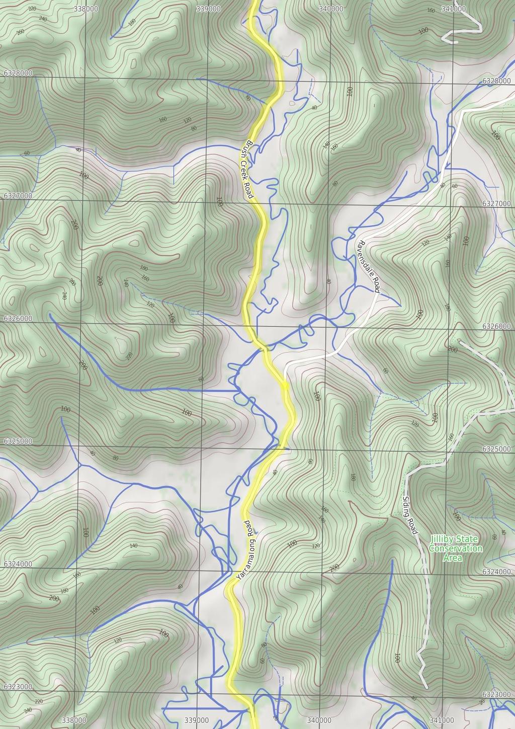
5 26.7 Yarramalong Track Head (11 km 3 hrs 18 mins) Turn left: From the 'Yarramalong Trackhead' (at the intersection of Yarramalong and Bumble Hill Roads), this walk follows the 'Cedar Brush Creek' sign along Yarramalong Road, away from Yarramalong Store. This walk continues through Yarramalong for about 400m, to cross a bridge over the Wyong River. Then this walk continues straight ahead past farm properties, undulating gently, for just shy of 3km, until coming to a three-way intersection, with 'Brush Creek Road' and a GNW 'Cedar Brush' sign on the left. Veer left: From the intersection, this walk follows the GNW arrow marker and Brush Creek Road gently downhill, while keeping Ravensdale Road on your right. This walk continues gently uphill, passing numerous farm properties for about 300m, then crossing a timber bridge. Then this walk continues on gravel road (with occasional sealed sections) amongst more farm properties for about 6.7km, crossing over a timber bridge to find a fourway intersection with 'Kingtree Ln' and 'Misty Valley Ln'. This walk continues straight ahead for another 600m, until coming to an intersection with the 'Cedar Brush Trackhead' sign and track on the right. a gentle rise for about 400m, then comes to a three-way intersection with a trail (on the left) marked with 'The Great North Walk' sign Int of GNW AND an unsealed road (380 m 9 mins) Turn left : From the intersection, this walk follows the 'The Great North Walk' sign south-west, gently downhill along the fairly wide trail. The walk continues down for about 400m, becoming moderately steep partway, to come to an intersection marked with a GNW arrow marker (pointing right) Int of GNW track AND a rocky trail (910 m 25 mins) Turn right: From the intersection, this walk follows the GNW arrow post east along the narrow track, which soon bends left and crosses the trail (just below the last intersection). Here, this walk follows the GNW arrow post moderately steeply downhill along the track, and down some stone steps for about 50m. The walk continues for about 700m along the side of the hill. Here the track leads steeply downhill, down a series of timber and rock steps for another 150m, to find a T-intersection with the 'Lyrebird Trail', also marked with a 'Basin camping area' sign Cedar Brush Track Head (2 km 58 mins) Turn right: From the signposted 'Cedar Brush Creek Trackhead' (on Brush Creek Road), this walk crosses the stile and follows the track gently downhill, while following the 'Newcastle' sign. The walk continues for about 220m then crosses a timber and metal bridge. On the other side of the bridge, the walk heads gently uphill, past the 'Please keep on track' sign, then about 100m later this walk comes to 'The Great North Walk Walkers Register' book on a post - a good place to note your intentions. Now in a denser forest, the track begins to wind moderately steeply uphill (crossing over two moist gullies) for about 1.5km until coming to a three-way intersection with Kingtree Ridge Road Int of GNW tracks AND Lyrebird Trail (1.9 km 47 mins) Turn sharp left: From the intersection, this walk follows the 'Basin Camping Area' sign along the track, while keeping Wollombi Brook on your right. The walk continues through dense vine and mossy forest as the track gently undulates along the side of the gully. Over the first 700m, the track leads past a few sandstone caves and crosses over several small creeks. The walk then continues for another 1.2km, where the track enters a more open forest on a saddle. At the edge of this saddle is an intersection with the Rock Lilly trail (signposted 'The Basin Camping Area' sign on the right) and a GNW arrow marker pointing directly ahead (also leading to the Basin campsite) Int of GNW track & Kingtree Ridge Fire Road (120 m 3 mins) Turn right: From the intersection, this walk follows the GNW arrow post gently uphill along the dirt Kingtree Ridge Road. The walk heads north along the dirt road for about 130m, coming to a flat GNW rest area with a couple of simple bench seats (on your left) Int of Rock Lilly and Lyrebird trails (340 m 7 mins) Continue straight: From the intersection on the saddle, this walk follows the GNW arrow marker gently downhill heading west (directly away from 'The Basin Camping Area' sign). The walk continues through tall open forest for about 300m, until coming to the large open clearing and Basin campsite Walkers Rest Area This GNW walkers rest area (signposted) is located beside King Ridge Road, and consists of two benches, a campfire and enough room for four or five tents on a grassy level surface. There is no water is available GNW rest area (3.4 km 1 hr 4 mins) Continue straight: From the GNW rest area, this walk follows the dirt Kingtree Ridge Road gently uphill, whilst initially keeping the rest area on your left. The walk follows the series of GNW arrow markers, ignoring a few side roads for about 3.4km, until coming to a Tintersection with the dirt Walkers Ridge Road, marked with a 'Walkers Rest Area 3.4 km' sign pointing back along the road Int of Kingtree Ridge and Walkers Ridge Roads (370 m 8 mins) Turn left: From the intersection, this walk heads along Walkers Ridge Road, following the Great North Walk arrow west over the hill, past Bobs Point Rd (on the left) and coming down the other side to the signposted intersection on the Great North Walk Int of GNW & Walkers Ridge Road (370 m 7 mins) Veer right: From the intersection, this walk follows 'The Great North Walk' sign and GNW arrow marker north east along the dirt road. The walk continues through forest (ignoring side roads) as it leads over Basin Campsite This large campsite sits by Wollombi Brook on the Great North Walk and is accessible by car. The campsite provides a range of facilities such as a pit toilet, picnic tables and chairs, wood BBQs and fireplaces. Water is usually available from the water tank or the nearby creek - treat before use.

6

7
8

9

10

11
12 Summary navigation sheet for the Somersby to the Basin Campsite km From 0.00 Somersby Store , (GR Wyong, ) End of Kilkenny Road , (GR Wyong, ) creek crossing , (GR Wyong, ) Palm Grove Campsite intersection , (GR Wyong, ) Ourimbah Valley Trackhead , (GR Wyong, ) Int of Platypus Creek La and Ourimbah Creek Rd , (GR Wyong, ) Forty Acres , (GR Wyong, ) End of day , (GR Wyong, ) Stringy Bark Point , (GR Wyong, ) Int of Great North Walk and Tooheys Road south , (GR Wyong, ) Int of Old GNW track and Tooheys Rd , (GR Wyong, ) Int of GNW and Tooheys Road north , (GR Wyong, ) Powerline tower west of Dead Horse Creek , (GR Wyong, ) Int of Great North Walk and Cherry Lane , (GR Mangrove, ) Int of Greta Road and Cherry Lane , (GR Kulnura, ) Int of Greta Road and power line service trail , (GR Kulnura, ) Bumble Hill Dray track tower , (GR Kulnura, ) Int of Great North Walk and Bumble Hill Road , (GR Dooralong, ) End of day , (GR Dooralong, ) Up/Dwn Length Initial directions (Use full tracknotes and maps for more detail) km 48 mins 1.4 km 32 mins 1 km 28 mins 990 m 24 mins 1.8 km 32 mins 2 km 36 mins 1.8 km 33 mins 0m From the Somersby Store, this walk heads north, gently downhill along the side of 'Wisemans Ferry Rd', past the public toilet. Continue straight: From the northern end of Kilkenny Road next to 'Illawong' (farm), this walk follows the 'The Great North Walk' sign along the management trail, between the two farms. Continue straight: From beside the creek, this walk follows the GNW arrow post uphill, using the series of rock steps. Turn left: From the intersection, this walk follows the GNW arrow post north-west, gently down off the side of the ridge (initially keeping the campsite track down to your right). Turn sharp left: From the 'Ourimbah Valley Trackhead' (on Ourimbah Creek Rd), this walk follows the 'Newcastle' sign downhill along the dirt road. Continue straight: From the gate (near the intersection of Ourimbah Creek Road and Platypus Creek La), this walk heads up around the locked gate and follows the Ourimbah Creek Rd trail along the side of the valley f... Turn left: From the intersection, this walk follows the 'Great North Walk' sign north-east along the clear trail. 1.8 km 53 mins 2.3 km 52 mins 160 m 3 mins 1.9 km 48 mins 1.5 km 30 mins 1.4 km 27 mins 430 m 9 mins 670 m 15 mins 4.6 km 2 hrs 310 m 6 mins 0m Veer right: From Stringy Bark Point campsite, this walk heads across the timber and metal footbridge (with a small mossy canyon on your right). Turn left: From the intersection, this walk follows the 'Camping Area' sign north, down along the wide dirt road. Optional sidetrip to Archers Campsite. Continue straight: From the intersection, this walk follows the GNW arrow post uphill along the wide dirt road. Turn sharp left: From the intersection, this walk follows the 'Yarramalong' sign along the narrow track (away from the dirt road) following a small ridge. Continue straight: From the high tension powerline tower, this walk heads uphill along the widening track, initially keeping the tower on your left. Turn right: From the intersection, this walk follows the GNW arrow post gently uphill along Cherry Lane, a gravel road. Turn right: From the intersection, this walk follows the 'The Great North Walk' sign gently uphill along the grassy verge (under the power lines) keeping Greta Road just to your left. Turn left : From the intersection, this walk follows the 'Great North Walk' sign over the fence using the stile. This is the planned overnight stay for the end of day 1, happy camping. Veer right: From the intersection at the base of the tower, this walk follows the GNW arrow post steeply downhill for a short distance, then turns right and follow another GNW arrow post into the bush. Veer left: From the intersection, this walk follows GNW arrow post gently downhill along the sealed Bumble Hill Rd. This is the planned overnight stay for the end of day 2, happy camping.
13 Summary navigation sheet for the Somersby to the Basin Campsite km From Yarramalong Track Head , (GR Dooralong, ) Cedar Brush Track Head , (GR Dooralong, ) Int of GNW track & Kingtree Ridge Fire Road , (GR Dooralong, ) GNW rest area , (GR Dooralong, ) Int of Kingtree Ridge and Walkers Ridge Roads , (GR Morisset, ) Int of GNW & Walkers Ridge Road , (GR Morisset, ) Int of GNW AND an unsealed road , (GR Murrays Run, ) Int of GNW track AND a rocky trail , (GR Murrays Run, ) Int of GNW tracks AND Lyrebird Trail , (GR Murrays Run, ) Int of Rock Lilly and Lyrebird trails , (GR Murrays Run, ) Powered by TCPDF ( Up/Dwn Length Initial directions (Use full tracknotes and maps for more detail) km hrs 18 mins km mins m 0 3 mins km hr 4 mins m mins m -5 7 mins m mins m mins km mins m mins Turn left: From the 'Yarramalong Trackhead' (at the intersection of Yarramalong and Bumble Hill Roads), this walk follows the 'Cedar Brush Creek' sign along Yarramalong Road, away from Yarramalong Store. Turn right: From the signposted 'Cedar Brush Creek Trackhead' (on Brush Creek Road), this walk crosses the stile and follows the track gently downhill, while following the 'Newcastle' sign. Turn right: From the intersection, this walk follows the GNW arrow post gently uphill along the dirt Kingtree Ridge Road. Continue straight: From the GNW rest area, this walk follows the dirt Kingtree Ridge Road gently uphill, whilst initially keeping the rest area on your left. Turn left: From the intersection, this walk heads along Walkers Ridge Road, following the Great North Walk arrow west over the hill, past Bobs Point Rd (on the left) and coming down the other side to the signposted... Veer right: From the intersection, this walk follows 'The Great North Walk' sign and GNW arrow marker north east along the dirt road. Turn left : From the intersection, this walk follows the 'The Great North Walk' sign south-west, gently downhill along the fairly wide trail. Turn right: From the intersection, this walk follows the GNW arrow post east along the narrow track, which soon bends left and crosses the trail (just below the last intersection). Turn sharp left: From the intersection, this walk follows the 'Basin Camping Area' sign along the track, while keeping Wollombi Brook on your right. Continue straight: From the intersection on the saddle, this walk follows the GNW arrow marker gently downhill heading west (directly away from 'The Basin Camping Area' sign).
Somersby to Yarramalong via Stringy Bark Point
 Somersby to Yarramalong via Stringy Bark Point 2 Days Hard track 26.7 km One way 4 1201m This section of the Great North Walk starts form the Somersby General Store and follows the Great North Walk north
Congewai Track Head (East) to Watagan Headquarters
 to Watagan Headquarters") Congewai Track Head (East) to Watagan Headquarters 7 hrs Hard track 17.2 km One way 4 973m This full day walk starts from the Congewai valley trackhead (east) and follows the Great North Walk up into the
Congewai Track Head (East) to Watagan Headquarters 7 hrs Hard track 17.2 km One way 4 973m This full day walk starts from the Congewai valley trackhead (east) and follows the Great North Walk up into the
Abbotts Falls Walking Track
 Abbotts Falls Walking Track 3 hrs 7.3 km Circuit Hard track 329m This circuit takes you through both dry and moist forest, using a combination of walking trails and wider tracks. The side trip to the dammed
Berowra Waters to Cowan Station
 Berowra Waters to Cowan Station 3 hrs 30 mins 7.2 km One way Hard track 597m This is a hilly walk out of the beautiful Berowra Waters valley to Cowan Station. There are many wide views across Berowra Creek
Mt Kuring-gai Track to Berowra station
 Mt Kuring-gai Track to Berowra station 4 hrs 15 mins 9.7 km One way Hard track 4 553m This walk explores three valleys, with great displays of wild flowers in spring, and some nice sandstone overhangs.
Staples Lookout to Mt Wondabyne loop
 Staples Lookout to Mt Wondabyne loop 4 hrs 3 mins 1.8 km Circuit Hard track 337m This walk starts and finishes at Staples Lookout, on Woy Woy Rd. The walk follows sections of the Great North Walk around
Girrakool to Wondabyne station
 Girrakool to Wondabyne station 4 hrs Hard track 9.5 km One way 4 438m This walk starts from the Girrakool picnic area and winds south, through the Brisbane Waters National Park. The walk crosses some long
Merritts Traverse. 1928m
 Merritts Traverse 3 hrs Hard track 5.8 km Circuit 4 167m This walk starts with a scenic journey to the top of the hill on the chairlift. Starting along Merritts Nature walk, this walk soon detours down
Nature Track. 900m. 789m. 2 hrs 3.1 km Circuit. Hard track 238m. Blue Mountains National Park
 Nature Track 2 hrs 3.1 km Circuit Hard track 238m Largely following the ridges around the top edge of Wentworth Falls, this track is incredibly beautiful. After taking in the great views at Edinburgh Castle
Leura Cascades to Gordon Falls Reserve
 Leura Cascades to Gordon Falls Reserve 1 hr 15 mins 1.8 km One way Moderate track 200m From Leura Park to Gordon Falls Park, this diverse walk offers fantastic views of the Jamison Valley, as well as two
Victoria Falls Lookout to Blue Gum Forest
 Victoria Falls Lookout to Blue Gum Forest 8 hrs Experienced only 13.8 km One way 5 112m This long day-walk follows a remote track down from Victoria Falls lookout, passing the waterfall, and into the Grose
Erskine Creek via Pisgah Rock and Jack Evans
 Erskine Creek via Pisgah Rock and Jack Evans 4 hrs 30 mins 7.1 km Circuit Very experienced only 6 421m This walk visits some great lookouts and explores the lower section of Erskine Creek. Most of the
Berowra to Cowan via Berowra Waters
 Berowra to Cowan via Berowra Waters 6 hrs Hard track 12.9 km One way 4 884m With train station at each end this walk explores the ridges and valleys around Berowra Waters. There are plenty of excellent
Guthega to Mt Twynam. 2183m. 1583m. 6 hrs 45 mins 14.8 km Return. Experienced only. 913m
 Guthega to Mt Twynam 6 hrs 45 mins 14.8 km Return Experienced only 5 913m This walk starts from Guthega and makes its way along the Snowy River to the Illawong Lodge, via the Blue Cow Creek flying fox.
Wondabyne station to Somersby Store
 Wondabyne station to Somersby Store 10 hrs Hard track 26.2 km One way 4 1164m This walk, following a section of the Great North Walk, starts from the Wondabyne train station and winds north, into the Brisbane
Crosslands to Cowan. 220m
 Crosslands to Cowan 7 hrs 30 mins 14 km One way Hard track 4 1103m This section of the Great North Walk starts from the Crosslands camping area and winds north alongside Berowra creek, passing through
Crosslands to Berowra Waters return
 Crosslands to Berowra Waters return 6 hrs Hard track 13.7 km Return 4 1005m This return walk starts from the Crosslands Reserve and follows the Great North Walk along Berowra creek. The walk includes some
Jerusalem Bay Track (Cowan to Brooklyn)
") Jerusalem Bay Track (Cowan to Brooklyn) 5 hrs 30 mins 13.4 km One way Hard track 4 654m This Cowan to Brooklyn Station walk is a popular section of the Great North Walk, with scenery ranging from foreshore
Jerusalem Bay Track (Cowan to Brooklyn) 5 hrs 30 mins 13.4 km One way Hard track 4 654m This Cowan to Brooklyn Station walk is a popular section of the Great North Walk, with scenery ranging from foreshore
Girrakool to Wondabyne station via Pindar caves
 Girrakool to Wondabyne station via Pindar caves 7 hrs 30 mins 18.1 km One way Experienced only 5 741m This walk starts from the Girrakool picnic area and winds south, following Piles creek into the Brisbane
Dadder Cave and Jack Evans track
 Dadder Cave and Jack Evans track 2 Days 10.3 km Circuit Very experienced only 535m This fairly short overnight walk is a great way to explore Erskine Creek. The walking along Erskine creek is mostly off
Gibberagong Track. 169m
 Gibberagong Track 2 hrs 30 mins 6.5 km One way Hard track 4 180m Starting in suburban Wahroonga, this wellmaintained track follows Cockle Creek down to Bobbin Head in the Ku-ring-gai Chase National Park.
Wentworth Pass. 893m. 535m. 4 hrs. Hard track 5.1 km Circuit. 692m
 Wentworth Pass 4 hrs Hard track 5.1 km Circuit 4 692m This walk offers a great way to explore the magical, upper section of the Valley of the Waters. The walk starts and finishes at Conservation Hut, which
Scenic Railway to Ruined Castle
 Scenic Railway to Ruined Castle 7 hrs 30 mins 12.4 km Return Hard track 4 963m This is a very popular, full day walk, in the Katoomba Area, offering great views of the valley. The walk follows the edge
Patonga to Staples Lookout
 Patonga to Staples Lookout 6 hrs 3 mins 17 km One way Hard track 4 72m This great walk explores much of the main ridge ridge running through Brisbane Water National Park. The walk visits a number of great
National Pass. 893m. 665m. 3 hrs 30 mins 4.6 km Circuit. Hard track 773m. Blue Mountains National Park
 National Pass 3 hrs 3 mins 4.6 km Circuit Hard track 773m 4 This walk offers fantastic views of the Jamison Valley and the surrounding cliffs. Take time to explore the historic and very scenic ledge halfway
Patonga to Wondabyne station via Mt Wondabyne
 Patonga to Wondabyne station via Mt Wondabyne 7 hrs 3 mins 19.5 km One way Hard track 4 861m This walk explores some grand views, pleasant cascades, varied bushland and remote areas of Brisbane Waters
Hornsby station to Crosslands
 Hornsby station to Crosslands 6 hrs 45 mins 16.1 km One way Hard track 4 938m This section of the Great North Walk starts from Hornsby train station and winds down along the Blue Gum Walk into Fishponds.
Lady Carrington Drive
 Lady Carrington Drive 3 hrs 45 mins 9.7 km One way Moderate track 3 266m This walk follows the historic Lady Carrington Drive alongside the Hacking River. The old road is closed to traffic and provides
Victoria Falls to Blackheath Station
 Victoria Falls to Blackheath Station 2 Days Experienced only 22.2 km One way 5 1561m This is a fantastic overnight walk with a sleep in Acacia Flats camping area. The Grose Valley, with its views of the
Berowra to Hornsby. 9 hrs 18 mins 22.6 km One way. Hard track. 1423m
 Berowra to Hornsby 9 hrs 18 mins 22.6 km One way Hard track 4 1423m One of the longer day walks in Berowra Valley National Park, this walk mostly follows Berowra Creek along the Great North Walk. Excellent
Victoria Falls and Grose Valley to Blackheath Station
 Victoria Falls and Grose Valley to Blackheath Station 3 Days Experienced only 22.5 km One way 5 158m This walk explores a fantastic section of the Grose Valley. Starting above Victoria Falls, the walk
Patonga to Wondabyne station via Pindar Caves overnight
 Patonga to Wondabyne station via Pindar Caves overnight 2 Days Experienced only 28.1 km One way 5 1164m This overnight hike starts from Patonga beach and winds along a section of the Great North Walk,
Crosslands to Brooklyn
 Crosslands to Brooklyn 2 Days Hard track 27.4 km One way 4 1757m From the Crosslands Reserve, this walk heads along the Great North Walk via Berowra Waters, Cowan, Jerusalem Bay and onto Brooklyn. This
COLOUR G U I D E. Sydney to Newcastle: Australia s most accessible long-distance walk
 COLOUR G U I D E Sydney to Newcastle: Australia s most accessible long-distance walk Woodslane Press Pty Ltd Unit 7/5 Vuko Place Warriewood, NSW 2102 Australia Email: info@woodslane.com.au Tel: (02)
Cowan to Wondabyne station via Patonga rest area
 Cowan to Wondabyne station via Patonga rest area 2 Days Hard track 33.4 km One way 4 1523m This section of the Great North Walk starts from Cowan train station and wanders past the majestic Jerusalem Bay
Main Range Walk - Charlotte Pass to Mount Kosciuszko
 Main Range Walk - Charlotte Pass to Mount Kosciuszko 9 hrs Hard track 21.9 km Circuit 4 920m This full day walk explores some of the greatest alpine country on offer in NSW. The walk grants views of Blue,
Blackheath to Blue Gum loop
 Blackheath to Blue Gum loop 2 Days Hard track 24.1 km Circuit 4 1335m This walk is great for fit people getting into overnight walking, with its fantastic scenery and nostalgia as a classic overnighter.
Main Range Track - Loop from Charlotte Pass camping near Mt Townsend
 Main Range Track - Loop from Charlotte Pass camping near Mt Townsend 2 Days Experienced only 27.7 km Circuit 5 1260m This great overnight walk starts from Charlotte Pass and provides access to some of
Leura to Katoomba via Dardanelles Pass
 Leura to Katoomba via Dardanelles Pass 4 hrs 6.6 km One way Hard track 697m With approximately equal parts cliff-walk and forest track, this track truly shows what the cliff edges of the Jamison Valley
Gordon to Hornsby (overnight at Scout camp)
") Gordon to Hornsby (overnight at Scout camp) 2 Days Hard track 25.8 km One way 4 125m This overnight walk starts from Gordon train station and winds through bush filled valleys to Hornsby station. From
Gordon to Hornsby (overnight at Scout camp) 2 Days Hard track 25.8 km One way 4 125m This overnight walk starts from Gordon train station and winds through bush filled valleys to Hornsby station. From
Guthega to Thredbo camping overnight at Wilkensons Creek
 Guthega to Thredbo camping overnight at Wilkensons Creek 2 Days Experienced only 25.8 km One way 5 1364m This great overnight walk explores the Kosciusko National Park between Guthega and Thredbo, visiting
Western Commission Track to Dubbo Gully
 This two day walk follows a series of historic roads along clear and wide management trails. This walk explores the great views from Western Commission Track, the sandstone handicraft on the Old Great
Thornleigh to Cowan. 2 Days. Hard track 35.9 km One way. 2337m
 Thornleigh to Cowan 2 Days Hard track 35.9 km One way 4 2337m Following the Great North Walk and Berowra Creek through Berowra Valley Regional Park, this walk cuts straight through the length of the Park.
Katoomba to Wentworth Falls via the Jamison Valley
 Katoomba to Wentworth Falls via the Jamison Valley 2 Days Experienced only 29.2 km One way 5 2135m This is the two day version of this popular and challenging walk. This walk passes popular sights including
Main Range Circuit from Guthega
 Main Range Circuit from Guthega 4 Days Experienced only 45 km Circuit 5 2317m This four day walk explores the Kosciuszko National Park, covering many of the key features of the park between Guthega and
The Prince Henry Cliff Walk
 The Prince Henry Cliff Walk 3 hrs 30 mins 6.8 km One way Moderate track 3 575m Going from Katoomba to Leura, this walk covers the top of the cliff line and most of the major lookouts. With brilliant vistas
Victoria Falls and Grose Valley to Blackheath Station
 This walk explores a fantastic section of the Grose Valley. Starting above Victoria Falls, the walk explores the cascades before dropping into the valley for the first nights rest at Burra Korain campsite.
Out and about at Geehi
 Geehi Geehi Flats is a large area of flat floodplain on the banks of the Swampy Plains River. Located within Kosciuszko National Park, it is home to a popular campsite in summer for people wanting to enjoy
Printed in China by Designed by Coral Lee Main cover image: Broken Bay
 Woodslane Press Pty Ltd Unit 7/5 Vuko Place Warriewood, NSW 2102 Australia Email: info@woodslane.com.au Tel: (02) 9970 5111 Fax: (02) 9970 5002 http://travelandoutdoor.bookcentre.com.au First published
GOLDEN EARS PROVINCIAL PARK
 GOLDEN EARS PROVINCIAL PARK Trail Information as of October 10 th 2015 Do not underestimate the mountainous wilderness of Golden Ears Provincial Park. The combination of rugged terrain and rapidly changing
Hindhead, Keffolds Copse and Gibbet Hill
 point your feet on a new path, Keffolds Copse and Gibbet Hill Distance: 6 km=4 miles Region: Surrey Author: Schwebefuss Refreshments: Punch Bowl Café moderate walking Date written: 14-apr-2015 Last update:
Slad over to Pitchcombe and back
 The walk climbs up from Slad over Wickridge Hill, descends to near Pitchcombe, then climbs back over Wickridge hill and round the back of Slad. Page 1 Start Point: SO 8718 0732 The Woolpack, Slad Length:
Tiger Mountain State Forest:
 98 60 hikes within 60 miles: SEATTLE 20 Tiger Mountain State Forest: West Tiger Mountain Three Loop i KEY AT-A-GLANCE INFORMATION Length: 5.1 miles round-trip Configuration: Loop Difficulty: Moderate difficult
Self-Guided Walk Langdale Pikes. Start & Finish: NT car park (free to members) at Sticklebarn - on the right just beyond the New Dungeon Ghyll hotel.
 at Sticklebarn - on the right just beyond the New Dungeon Ghyll hotel.") Self-Guided Walk Langdale Pikes Key Information These mountains form a collection of spires and cliffs on the north side of Langdale. This walk visits four of the main tops Pavey Ark, Harrison Stickle,
Self-Guided Walk Langdale Pikes Key Information These mountains form a collection of spires and cliffs on the north side of Langdale. This walk visits four of the main tops Pavey Ark, Harrison Stickle,
Hiking Trail Descriptions
 Hiking Trail Descriptions For ye shall go out with joy. And be led forth with peace. The mountains and the hills shall break forth before you in singing. And all the trees of the fields shall clap their
Leaden Boot Challenge 2016 ROUTE INSTRUCTIONS
 Leaden Boot Challenge 2016 ROUTE INSTRUCTIONS Section 1 Alstonefield to Ilam (CP2) From the village hall car park turn R then L and pass through the village keeping to the R to enter Church Street. Pass
Leaden Boot Challenge ROUTE INSTRUCTIONS
 Leaden Boot Challenge ROUTE INSTRUCTIONS Section 1 Alstonefield to Ilam From the village hall car park turn R then L and pass through the village keeping to the R to enter Church Street. Pass the Church
The Mendip Way. Route Directions and Maps Uphill to Wells
 The Mendip Way Route Directions and Maps Uphill to Wells Website: www.mendiphillsaonb.org.uk Email: mendip@mendiphillsaonb.org.uk Facebook & Twitter: @MendipHillsAONB Phone: 01761462338 1 Uphill to Loxton
Festum Prophetae. 200, 300, 400 & 600km Mixed Terrain Audax Rides Saturday 16 th & Sunday 17 th June 2018
 Festum Prophetae 200, 300, 400 & 600km Mixed Terrain Audax Rides Saturday 16 th & Sunday 17 th June 2018 Festum Prophetae or "The Festival of the Prophet" is a worldwide celebration of The Prophet, Eddy
Pontfadog. Walk A. Walk A
 Walk A A Bird s eye view of the village 2km. (1 1 /2 miles); height gain 45m. (150ft) about 45 minutes. Six minutes walk along the main road towards Glyn Ceiriog reach a signpost to Llwynmawr. Take the
Telluride-to-Moab Alternative Singletrack Options
 Telluride-to-Moab Alternative Singletrack Options Day 1 Day 1 Alternate 1: Galloping Goose to Deep Creek. 18.4 miles, ascent 3,530ft, descent 1,388ft. This is fun, flowey, moderate to intermediate singletrack
Central Coast Hunter Range Region Discovery Program
 Central Coast Hunter Range Region Discovery Program Sydney to Newcastle General Inquiries NPWS (02) 4320 4200 (Monday - Friday) Detailed Information Anne Whyte, Discovery Coordinator NPWS (02) 4320 4205
Camp Jack Wright PERMANENT ORIENTEERING COURSE (2004)
") Camp Jack Wright PERMANENT ORIENTEERING COURSE (2004) WHAT IS ORIENTEERING? The skill which enables a person to navigate with a map. In the competitive sport, the winner is the person who finishes in the
Camp Jack Wright PERMANENT ORIENTEERING COURSE (2004) WHAT IS ORIENTEERING? The skill which enables a person to navigate with a map. In the competitive sport, the winner is the person who finishes in the
beach. Make the ford and follow the trail out to the junction with Red Creek Tr in an open grassy area.
 Description: This is a moderate to slightly strenuous 22.8 mile backpack (add 2.6 miles if you do the packless out and back to the Lion s Head) that will have you exploring nearly every thing that is The
This path goes past an old tree nursery and sawmill. After 800m it crosses over a lane. Follow the bridleway fingerpost into the woods.
 FRENSHAM PONDS 11K CIRCULAR TRAIL 2½ HRS GU10 2DA This magnificent heathland trail starts in woodland and then brings you out onto the open heather of Frensham Common, with no roadwork! The route runs
Little Grand Canyon near Pomona, Illinois
 Little Grand Canyon near Pomona, Illinois Below: View of the trail and the terrain created using the Map My Hike app Below: Summary of the hike created using the Map My Hike app Presented by: Jennifer
Trail Phasing Plan. Note: Trails in the Clear Creek Canyon area (Segments will be finalized in the future to minimize wildlife impacts
 Note: Trails in the Clear Creek Canyon area (Segments 2 5 and a future JCOS connection) will be finalized in the future to minimize wildlife impacts Trail Phasing Plan P Parking 3 Easy Trail Intermediate
ROAD SCHOLAR SPRING HIKING ADVENTURE Tentative Schedule April 9-14, 2017
 ROAD SCHOLAR SPRING HIKING ADVENTURE Tentative Schedule April 9-14, 2017 Sunday, April 9 PM 3:00-5:00 Arrival, registration and move in to the dorm. 6:00 Supper EVE 7:15 Welcome & Orientation, Sign Ups
Our Murray River Beaches
 Page 1 of 5 Our Murray River Beaches Click here to print this page West of Yarrawonga are many access points to the river. Earth tracks lead from the Murray Valley Highway through state forests to picnic
CWMGIEDD FROM ABERCRAVE
 Abercrave to Cwmgiedd Walk Page 1 Starting from The Abercrave Inn. Grid Ref: SN 824128 From the Abercrave Inn, an 11.3km (7 miles) walk to the foothills of the Cribarth Mountain, then through forest to
Bewl Water & the High Weald
 1 Bewl Water & the High Weald Stonegate station - Stonegate - Wallcrouch - Newbarn - Cousley Wood - Wood's Green - Wadhurst station Length: 9 ½ miles (15.3km) Underfoot: Large portions of this path are
TREK THE ROCKIES ABOUT THE CHALLENGE TREK THE ROCKIES FOR HIGHLAND HOSPICE CANADA TREK DEMANDING
 TREK THE ROCKIES CANADA TREK DEMANDING ABOUT THE CHALLENGE The Canadian Rockies are justifiably world-famous for their magnificent scenery: the combination of impressive, jagged mountains, bright turquoise
Marilla Reservoir to Chestnut Ridge via Marilla Trails and Bullis Hollow Trail east to west
 USGS topographic maps useful to this hike are the Bradford and Stickney 7.5 minute sectionals. These notes are designed to assist in identifying distance and location using geophysical and man-made characteristics
BISHOPSTONE CIRCULAR WALK
 BISHOPSTONE CIRCULAR WALK 4½ miles (7¼ km) - allow 2 hours (see maps on final pages) Introduction This walk is within the North Wessex Downs Area of Outstanding Natural Beauty and starts from the small,
IRON BARK and COLENSO HUTS 260 Series Map: 1:50, U21 NZ Grid GPS: Geodetic Datum 1949
 IRON BARK and COLENSO HUTS 260 Series Map: 1:50,000 260-U21 NZ Grid GPS: Geodetic Datum 1949 Topo50 Map: BK36 Taoroa Junction GPS: on WGS84 How to get to START: Exit Taupo on SH1 down the lake to Turangi
Reigate Hill and Gatton Park
 point your feet on a new path Reigate Hill and Gatton Park Distance: 11½ km=7 miles easy-to-moderate walking or 2 walks of 6½ km=4 miles and 5½ km=3½ miles Region: Surrey Author: Schwebefuss Refreshments:
Sponsored by. statestreet.com
 /STATESTREETISLANDWALK #ISLANDWALKJSY Sponsored by statestreet.com Important Information If you forget everything else PLEASE remember the following.» Remember to check OUT of every checkpoint» If you
Ystwyth and Rheidol Bridleway Routes. Route 2:Llanilar Circular
 Ystwyth and Rheidol Bridleway Routes Route 2:Llanilar Circular Route overview and terrain: A long circle using connecting ridges with fine views to link the Rheidol and Ystwyth river valleys. The route
1. Waterfall Gully Mt Lofty. 5 Of the Best Hikes in Adelaide
 Adelaide is a beautiful city, and one of the most incredible things about Adelaide is the quality of bushwalking available on the suburban fringe. It is surrounded by the Mt Lofty Ranges, and much of the
Ardingly Lake, Ouse Valley, Borde Hill
 point your feet on a new path Ardingly Lake, Ouse Valley, Borde Hill Distance: 14 km=9 miles or 12½ km=8 miles Region: West Sussex Author: Hautboy Refreshments: Borde Hill Map: Explorer 135 (Ashdown Forest)
ID: 283 Distance: 6.2 miles Height gain: 500 Metres Map: Explore OL 19 Contributor David and Chris Stewart
 Walkingworld Wild Boar Fell ID: 283 Distance: 6.2 miles Height gain: 500 Metres Map: Explore OL 19 Contributor David and Chris Stewart Features Birds, Great Views, Hills or Fells Description: Wild Boar
Trail Beginning Elevation: 7553 ft The Poison Creek Trailhead is located at the end of National Forest Road 646E (NF-646E).
.") West Mountain Trails Poison Creek Trail #134 Length: 2.9 miles (4.7 km) Difficulty Horseback: A good trail for the first time west mountain rider, some steep sections Hiking: Most Difficult USGS Maps:
West Mountain Trails Poison Creek Trail #134 Length: 2.9 miles (4.7 km) Difficulty Horseback: A good trail for the first time west mountain rider, some steep sections Hiking: Most Difficult USGS Maps:
Beautiful Walks from the Blue Ball Inn
 Walk No. 5 RIVER VALLEYS AND MOOR Countisbury, Watersmeet, Hillsford Bridge, Cheriton, Shilstone Hill, Rockford and Chiselcombe. 8.5 MILES APPROX. Walking time four and a half hours approx. OS 1;25,000
Illawarra Escarpment State Conservation Area Walking Tracks
 Illawarra Escarpment State Conservation Area Walking Tracks NPWS Illawarra Area Office Ground Floor, Government Office Block 84 Crown Street Wollongong NSW 2500 02 4223 3000 (Mon-Fri) Royal National Park
This area is a popular holiday spot so watch out for 4WD vehicles and motorbikes at peak times.
 Mavora Walkway (Map 130, 129, 128) Southern Start Northern End Distance Time Track Standard Mavora Camping Area, Mavora Lakes Road Greenstone Station Road Carpark 50km 3 days Tramping track Hazards Never
START - UPHILL BEACH. (tidal!) The West Mendip Way is route-marked with these round blue signs
 The West Mendip Way is route-marked with these round blue signs") START - UPHILL BEACH Start Times: 10:30 11:15 12:00 Please allow sufficient time to check in with the marshals Start on the beach at the high water line (tidal!) The West Mendip Way is route-marked with
START - UPHILL BEACH Start Times: 10:30 11:15 12:00 Please allow sufficient time to check in with the marshals Start on the beach at the high water line (tidal!) The West Mendip Way is route-marked with
Walk 1. Cotswold Water Park. Gateway Centre to Cerney Wick, railway track to Lake 6, Gateway Centre.
 Cotswold Water ark Walk way A Swindon/ Cirencester Thomas and Severn Canal way to Cerney Wick, railway track to Lake, way. Spine Road East Hotel Time: hours (short walk km) Distance: km A level walk along
Lava Mountain Trail Distance: Elevation Range: Trail Type: Difficulty: Season: Driving Distance: Driving Time: USGS Maps: Pros Cons
 Lava Mountain Trail Distance: 13.4 miles (including the side trip to North Star Lake) Elevation Range: 5900'-8330' Trail Type: singletrack Difficulty: moderate Season: late June-October Driving Distance:
Kakadu Highlights No. 9: September 23 - October 6, 2018
 Kakadu Highlights No. 9: September 23 - October 6, 2018 Section 1: Barramundi Creek: September 23-26 We begin with a four to six hour, 350 kilometre drive from Darwin. The last 45 kilometres is on a 4WD
BURGHCLERE PARISH RIGHTS OF WAY
 BURGHCLERE PARISH RIGHTS OF WAY Full descriptions compiled by Neill & Miggie Bruce All photos Miggie Bruce FP23 on Ridgemoor, looking south, with FP22 crossing by the bush FP1. From C183 Aldern Bridge
HARDMOORS 55 RACE ROUTE 2018 HELMSLEY - GUISBOROUGH
 HARDMOORS 55 RACE ROUTE 2018 HELMSLEY - GUISBOROUGH HELMSLEY - CHECKPOINT 1 (WHITE HORSE) 1. Leave RACE START, continue ahead on road (Baxtons Sprunt) At crossroads turn right down Canons Garth eventualy
Route #2) Mt. Massive - Southwest Slopes
 Mt. Massive - Southwest Slopes") Route #2) Mt. Massive - Southwest Slopes Difficulty: Class 2 Ski: Advanced, D6 / R2 / III Exposure: Summit Elevation: Trailhead Elevation: Elevation Gain: Round-trip Length: Trailhead: County Sheriff:
Route #2) Mt. Massive - Southwest Slopes Difficulty: Class 2 Ski: Advanced, D6 / R2 / III Exposure: Summit Elevation: Trailhead Elevation: Elevation Gain: Round-trip Length: Trailhead: County Sheriff:
San Miguel to Caserio de la Hoya Circular (San Miguel)
") Tenerife Sur: Short Walks Under 10 km San Miguel to Caserio de la Hoya Circular (San Miguel) Route Summary An informative and scenic walk back in time from San Miguel to below El Roque, overlooking the
Tenerife Sur: Short Walks Under 10 km San Miguel to Caserio de la Hoya Circular (San Miguel) Route Summary An informative and scenic walk back in time from San Miguel to below El Roque, overlooking the
A DESERT CAMPING GUIDE FOR ANZA BORREGO DESERT STATE PARK
 A DESERT CAMPING GUIDE FOR ANZA BORREGO DESERT STATE PARK With over 500,000 acres of beautiful terrain, Anza Borrego Desert State Park offers endless opportunities for Boy Scout Troops, Venture Crews and
The Queen Stage. 100, 200 & 300 Audax Rides - Saturday 22 nd July 2017
 The Queen Stage 100, 200 & 300 Audax Rides - Saturday 22 nd July 2017 A challenging course including most of the big climbs through Northern Sydney before heading north towards Yarramalong and returning
East West route and Leatham Molesworth route (route guide) Molesworth Recreation Reserve
 Molesworth Recreation Reserve") East West route and Leatham Molesworth route (route guide) Molesworth Recreation Reserve 0BIntroduction The East West route links the Clarence (Kahutara River in Ka Whata Tu o Rakihouia) Conservation Park
East West route and Leatham Molesworth route (route guide) Molesworth Recreation Reserve 0BIntroduction The East West route links the Clarence (Kahutara River in Ka Whata Tu o Rakihouia) Conservation Park
CAMPSITE 411. Girl Scouts of Greater Atlanta, Inc.
 CAMPSITE 411 Girl Scouts of Greater Atlanta, Inc. What is provided for us at each campsite/cabin? Although each living unit (tents or cabins) is unique, you can expect to find certain unit equipment in
Fetcham Downs and Bocketts Farm A magical teashop walk
 point your feet on a new path Fetcham Downs and Bocketts Farm A magical teashop walk Distance: 3 km=2 miles or 4 km=2½ miles Region: Surrey Author: Fusszweig Refreshments: Bocketts Farm easy walking Date
Prince Regent National Park
 Prince Regent National Park 23 rd June- 14 th July 2019 Garimbu Creek, Moran and Roe River Area Notes written by Cassie Newnes This area has something for everyone, magnificent scenery, stunning waterfalls,
Trail Details Location
 Blind Blue Ribbon Centennial Conditions: Forest trail, with duckboards, and rope railing. Need: Blind trail activity bag, available in the camp office. None Availability: Open all seasons. Use the outdoor