A DESERT CAMPING GUIDE FOR ANZA BORREGO DESERT STATE PARK
|
|
|
- Collin Thompson
- 5 years ago
- Views:
Transcription

1 A DESERT CAMPING GUIDE FOR ANZA BORREGO DESERT STATE PARK With over 500,000 acres of beautiful terrain, Anza Borrego Desert State Park offers endless opportunities for Boy Scout Troops, Venture Crews and Varsity Teams searching for remote and rugged destinations for scout adventures. This guide is intended for Boy Scout Troops, Venture and Varsity Scouts. It is not intended for Cub Scout Packs. Only the two specific group campsites listed in this guide are approved by the Orange County Council Camping Guide for Cub Scout packs. When I ask other scout leaders where they go desert camping, they usually say Joshua Tree. When I ask if they have camped at Anza Borrego, they usually tell me they have heard about Anza Borrego, but don t know where to camp in Borrego. I have camped, hiked and backpacked in Anza Borrego since I was a tenderfoot scout many years ago. I am still finding and exploring new places. My hope is this guide will show you a few new places to camp, hike backpack and explore. Questions, Comments, Changes Contact Ren Higgins at or rshiggins@cox.net Anza Borrego Guide
2 Table of Contents Contact Anza Borrego State Park, Driving Directions, Map to Borrego...3 General Information...4 CAR CAMPING SITES Culp Valley Primitive : Hwy S22 near Mile Marker Blair Valley: Hwy S2 near Mile Marker 23, 6 miles south of junction HWY Mountain Palm Springs: Hwy S2, Mile Marker 47, 28 miles south of junction Hwy, Bow Willow Primitive Camp: Hwy S2 near Mile Marker BACKPACKING TRIPS Culp Valley, California Riding Hiking Trail...5 Borrego Springs, Maidenhair Falls...5 Coyote Canyon to Sheep Canyon, Cougar or Indian Canyon...6 & 7 Blair Valley Pictograph Trail to Smugglers Canyon...7 Blair Valley California Riding Hiking Trail, Box Canyon to Foot and Walker Pass...8 Mountain Palm Springs to Indian Valley...9 Bow Willow Canyon...10 Bow Willow to Rockhouse Canyon Loop...10 DAY HIKES Culp Valley - California Riding Hiking Trail...5 Culp Valley Pena Springs and Look Out Loop...5 Borrego Maidenhair Falls Trail...5 Borrego - Palm Canyon Nature Trail...5 Blair Valley Ghost Mountain...7 Blair Valley Morteros Trail...7 Blair Valley Pictograph Trail...7 Mountain Palm Springs Loop...8 Mountain Palm Springs - North Grove and Mary s Grove...8 Mountain Palm Springs to Indian Valley to Torote Canyon...9 Bow Willow to Mountain Palm Springs...9 Bow Willow Canyon...10 Bow Willow to Rockhouse Canyon Loop...10 Reference Topo Maps for campsites and hiking Anza Borrego Guide

3 Contact Anza Borrego State Park - (760) Download the Anza-Borrego Park Magazine from the website for more information on park rules, safety, trails, camps and maps. Directions to Anza Borrego I-5 South to Hwy 76 in Oceanside, then East on 76 to Hwy 79. Turn left, north on 79 for 4.5 miles. Turn right onto Hwy S2. Go 5 miles to the Junction of Hwy S2 & S22. Northern Borrego: Turn left on Hwy S22. This takes you to Borrego Springs and the Park Headquarters, Culp Valley, Sheep, Cougar and Indian Canyons. Southern Borrego: continue straight on Hwy S2 to reach Blair Valley, Mountain Springs and Bow Willow Camp. References to jeep roads and camp grounds are to the nearest mile markers on Hwy S2 and S22. Additional Maps - Pages are reference maps created from the TOPO map program. There is a map for each of the six different areas presented in this guide. The Latitude and Longitude is given to locate the primitive camp or trailhead for that area Anza Borrego Guide
4 Council Approved Camps for Cub Packs Group & Family Campsites with shower facilities, running water, and toilets: 1. Palm Canyon Campground, Borrego Springs. Make Reservations thru Reserve America Aqua Caliente County Park: Located on Hwy S2, 22 miles south of Junction of Hwy 78. It also has a swimming pool and a caravan area for groups. Contact San Diego County Parks: , Toll Free Open camping is allowed in most parts of the park. 1. In Anza Borrego, you do not have to camp in a campground, you can pick your own campsite. Use a pre-camped area! Do not clear vegetation to make a new campsite. 2. In a park about the size of Rhode Island, you have a lot of choices on where to camp, hike or backpack. While in Anza Borrego, you are bound to find a new place to explore. Spend time looking around for more unique places to hike or camp. Leave no Trace Camping: 1. The State Park requests that you practice Pack it in, Pack it out as well as follow all Leave No Trace Guidelines. 2. Park rules are posted on the website. You are responsible to know and follow them, as well as the Outdoor Code and all Guide to Safe Scouting Guidelines. 3. Fires are allowed if you bring a metal ground pan and your own wood. Trail Information 1. Obtain a current park map! If you are using the Topo Map Software Beware! Many of the jeep roads are not marked accurately or their routes have changed over the years. Many of the new trails in the park are not shown on the Topo program. 2. Park Maps can be obtained at the Visitors Center. Also, see the online park magazine. Important Cautions: 1. Conditions change from year to year. Contact the park ranger for current conditions and check out remote car camp areas in person before you go camping in the park. 2. The maps included with this guide are for reference and planning only. Obtain a current park map if you are hiking or backpacking in remote areas. 3. The desert can be a hostile and unforgiving environment. Make sure you have checked out the road and trail conditions in advance. Make sure your vehicle is in good condition. 4. Bring extra water, a shovel and an air pump. Bring 1 gallon of water per person per day. Everyone should wear a hat and sunscreen. Hot, dry conditions are possible at any time of year. Treat all water in the backcountry. 5. Be Prepared : Winter nights can quickly drop to below freezing temperatures! Day time temperatures can be in the high 80 s even in January! 6. Desert Safety Information- Scouter online website - California Parks Desert Safety tips website - Additional Reference Material Books Afoot and Afield in San Diego County, by; Jerry Schad Anza Borrego Desert Region, by; Lowell Lindsay Anza Borrego Guide
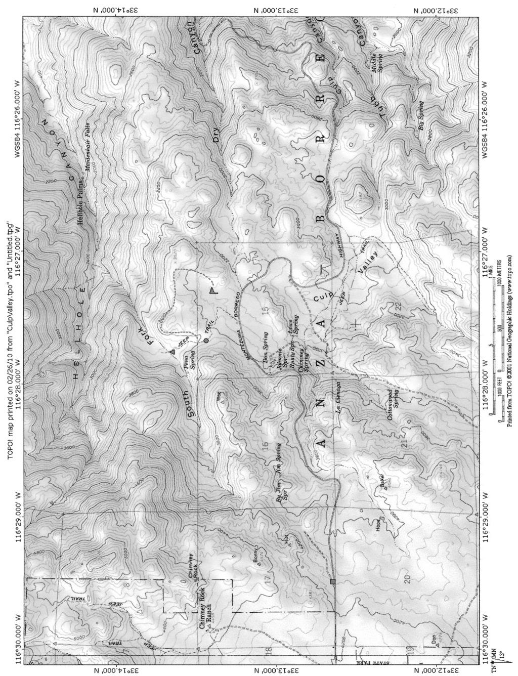
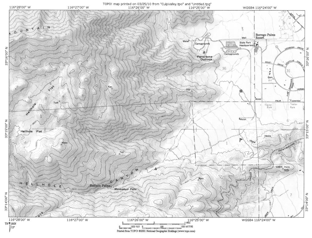
5 CULP VALLEY AREA Reference Map 1 - pg 11 Coordinates mark Culp Valley Camp off of Hwy S22. Long./Lat x Car Camping: Culp Valley Primitive Camp. Hwy S22 near mile marker 9. Take dirt road north off the highway, at.25 miles take the right fork to the camp ground. At 3,000ft, this is good a great area for early fall or late spring camping. Pit toilet, no water, several open camp areas. Left fork at.25 miles goes to trail parking & Pena Spring. Day Hikes Loop Hike: starting from camp hike northeast to the view area, then head west up the Riding Hiking Trail and you will find Pena Springs. Explore down the canyon and find a great view of Borrego Springs. Return to the spring, and take the Pena Spring road back to camp = 1.5 to 2 miles. Culp Valley to Borrego Springs: via the Riding Hiking Trail is 6 miles, a car shuttle is recommended. Start your hike from the camp and follow the Riding Hiking Trail down the mountain, ending at the parking area near the bottom of Montezuma grade (Maidenhair Falls Hike), or hike on to the Park Visitor Center and get picked up there. Jasper Trail Junction to Culp Valley, day hike: Start on S22 at mile marker 6.8 where the Jasper Trail crosses. Hike the 2.5 miles into Culp Valley. Meet the cars and camp. Backpacking: Start at the Jasper Trail crossing on S22. Backpack to Pena Springs and camp in the canyon below the spring. The spring has water year round. Continue the next day down to Borrego Springs on Riding Hiking Trail, total distance is about 8.5 miles downhill. Car shuttle required. Borrego Springs Reference Map 2 pg12 Coordinates mark Maidenhair Falls trailhead off of Hwy. S22. Long./Lat X Day Hike or Training Backpack Maidenhair Falls Parking: At the bottom of Montezuma Grade, Hwy S22 on the west side of the road. Pit toilet at trailhead, no water. The trails to Maidenhair Falls, for the California Riding Hiking Trail to Culp Valley and to the Park Headquarters and Visitors Center, start from here. Hike west from the parking area on the trail to Hellhole Canyon. Pass the Riding Hiking trail junction on your left and continue across the valley for about 1.5 miles. At this point you enter the mouth of Hellhole Canyon. The grade will get steeper and you should pass a mountain lion warning sign. If you are backpacking, the best places to stop and camp are here along the left side of the canyon, for the next ¼ mile. Beyond this the canyon narrows and gets steeper as the path winds between the palms and boulders. If water is not flowing, the falls may be had to find. Look for a wall of Maidenhair Ferns tucked between two large boulders screened by large sycamore trees. Explore farther up the canyon if you like. You can also start this hike from the Park Visitors Center. Day Hike - Palm Canyon Nature Trail A good day hike from the Palm Canyon campground is the nature trail to the palm groves. The loop trail is about 3.5 miles. If you are lucky, it is possible to see big horn sheep. Follow the well marked trail to the Palm grove. At 1 mile you cross the creek, there is a trail junction here. The left fork makes a loop hike for your return to camp Turn right, up canyon to reach the palm grove. The trail ends at the palm grove and waterfall. The adventurous hiker can scramble up the canyon through Anza Borrego Guide
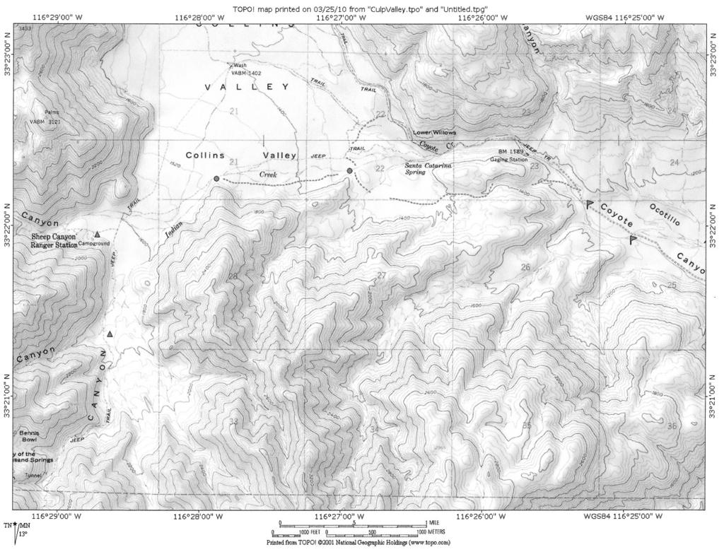
6 the boulder field to explore the canyon above the palm grove, where more palm groves can be found. Allow plenty of time for an up canyon adventure, there is no real trail above the grove. SHEEP CANYON, COUGAR CANYON & INDIAN CANYON: Backpacking Reference Map 3 pg13 Coordinates mark parking at 2 nd crossing. Long./Lat X All 3 canyons are good areas for training and advanced backpacking trips. High clearance vehicles are recommended to reach the trailhead at 2 nd or 3 rd crossing. Water flows in the Sheep and Cougar Canyons year round. Sheep Canyon Trail Camp has pit toilets and is suitable for large groups. Cougar Canyon and Indian Canyon are great remote camping areas for smaller groups. Treat all water! Driving Directions to the Trailhead: When you reach Borrego Springs via the S22, turn right at the stop sign, (restroom facilities are available to the left at the Visitors Center). Continue east on S22, through the traffic circle. Drive for 1/2 mile on S22, turn left on DiGorgio Road and continue for 5 miles. The paved road will end as you enter Borrego State Park. Follow this dirt road for 5 miles until you reach 2 nd crossing. There is a small parking area on the left and a water gauging tower. Depending on the water flow, the stream crossing here can be challenging. If in doubt, park and start hiking here. If you chose to drive across the creek, continue another ½ mile and park near the historic markers. Sheep Canyon: If you begin your hike at 2 nd crossing, cross the creek and follow the road past the markers. You have to cross the creek again at 3 rd crossing. On the west side of the creek is a trail junction, and I highly recommend this loop trip. Follow the jeep road up the narrow canyon, across the pass and down the other side. A side hike takes you to a historical marker. The jeep road passes through a small valley followed by a gap. After the gap the hiking trail breaks off to the left. It is marked by white posts. If you miss the hiking trail junction, continue on to the jeep road junction. The left fork takes you to the Sheep Canyon trail camp, Cougar and Indian Canyons. Right before you reach Sheep Canyon you will find the junction to Cougar & Indian Canyons. If you are camping at Sheep Canyon, continue west into the mouth of the canyon. The camp areas are near the two stone outhouses to your left. A shade structure and camp area are located 200 yards further up the canyon. The creek in Sheep Canyon runs year round and tends to soak into the desert sand quickly. If there is a lot of water flowing, you will find it in the wash opposite the shade structure. If the flow is low, work your way up canyon to find where the water is flowing. To make the loop hike, return on the jeep trail back to the jeep road junction in Collins Valley. Here you will find a marked trail that continues east. When the trail reaches the far canyon wall in the wash, it turns south into the Lower Willows, then follows the canyon back to 3 rd crossing. The trail is cleared annually by equestrian groups and should be easy to follow, but may be damp in places. Distances: 2nd crossing to Sheep Canyon via the jeep road is 4 miles, and 2nd Crossing to Sheep Canyon thru Lower Willows is 5 miles. Cougar Canyon: At the junction before you reach Sheep Canyon Trail Camp take the left fork (south). The road ends quickly and is replaced with a wide footpath, stay on this and head south. After approximately ¾ mile you will be opposite the mouth of Cougar canyon. Make camp in any open area left of the trail. If you are small group, you may find some camp areas in the canyon Anza Borrego Guide
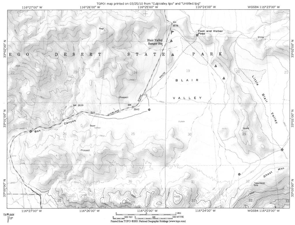
7 mouth. Water flows down to the mouth of the canyon. A good side hike is to scramble up the canyon and find the hidden palm groves. Indian Canyon: Follow the trail past Cougar Canyon going south another ¾ mile. The trail will bend south west into a narrow canyon where you will pass by the palm groves of Bennis Bowl. Because this specific trail can be brush choked and hard to follow there is limited camping. Water can be found farther up the canyon. The mine marked on the map can be found. You may want to get water in Cougar Canyon, make camp at the mouth of Indian Canyon and explore up the canyon without backpacks. BLAIR VALLEY Reference Map 4 - pg 14 Coordinates mark the restroom at Blair Valley entrance. Long./Lat X Just off of Hwy S-2, near mile marker 23, 6 miles south of Hwy 78 from Scissors Crossing. Blair Valley is a large valley with many places for car camping. No water is available. There are pit toilets at the valley entrance. The area is popular with weekend RV campers, resulting in many of the popular camp areas to be occupied by early Friday. There are 3 marked trails with interesting day hikes in the valley. The California Riding Hiking Trail passes thru Blair Valley providing a good training backpack or a day hike. For the more adventurous scouts the 5 mile drive into Little Blair Valley will provide a remote camp area. I recommend high clearance vehicles. Drive only on established roads and camp in previously camped in areas! Car Camping There is a good campsite on the left as you enter the valley, and a second camp area can be reached by turning right, and following the road for about 175 yards past the bathroom. A large pullout area is available for parking, with the camp area just beyond the posts. Further down the road against the low hill are 3 more large camp areas, and the Riding Hiking trail crosses near here. To reach additional camping: as you enter the valley, drive straight past the kiosk and follow the main jeep road to the three marked trailheads. Drive about 1.1 miles from the kiosk until you reach an area marked Group Camping. There is room for several troops to camp in this area. You will need to be self contained, there are no toilets, no water in this area! There are other camping areas scattered about Blair Valley, scout around. Hiking: Blair Valley Trailheads. See the road sign at the valley entrance for driving distances to the trailheads. These trailheads are marked with parking areas. Ghost Mountain Trail to Marshal South homestead is a 2 mile round trip. Ghost Mountain Trailhead; There is a cross country route to a jet crash site, the distance can be 2 to 3 miles depending on how far you explore. This is a good compass exercise for scouts! Send me an , and I ll send the directions. rshiggins@cox.net. Morteros Trail: ½ mile round trip has a Native American camp area with grinding holes. Pictograph Trail is a 2.5 miles round trip with areas to view Native American Pictographs. Backpacking Pictograph Trail to Smugglers Canyon Continue past the pictograph rock into Smugglers Canyon. Go left or right and find a place to make camp. This is a good training backpack. Anza Borrego Guide
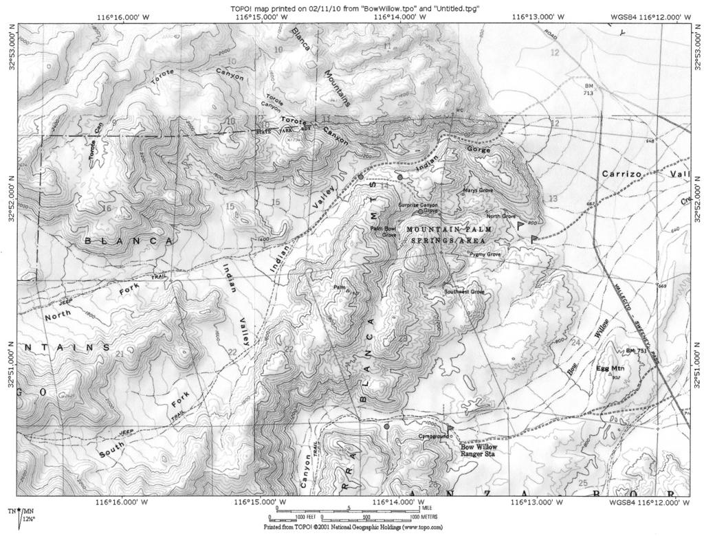
8 Box Canyon to Blair Valley The Riding Hiking trail crosses hwy S2 near mile marker The trail goes east up the wash following the old stage route. In about 2 miles the trail reaches the jeep road at the south end of Blair Valley. The trail turns north and follows the jeep road, past the low hill where there are camp areas, then across the dry lake to the Foot and Walker Pass. The pass is about 4 miles from Box Canyon. The second day you can continue north over the Foot and Walker Pass. After crossing the pass, follow the jeep road northwest. You reach hwy S2 in about 1 mile. Blair Valley California Riding Hiking Trail From the entrance kiosk go.5 miles mile into the valley and you will cross the California Riding Hiking Trail. Foot and Walker Pass will be on your left. This is the old Butterfield Stage Route. MOUNTAIN PALM SPRINGS Reference Map 5 - pg 15 Coordinates mark the restroom in campsite. Long./Lat X Car Camping, Day Hiking, Backpacking, Mountain Palm Springs has pit toilets, no water. Hwy S2. Mile Marker 47, 28 miles south jct. Hwy 78. Camping There are caravan camping areas near the toilet. These are usually occupied by RV campers. Tent camping is available in the sandy wash beyond the restroom facilities. A better car camp area is in the closed parking area. To find the closed parking area, as you approach the day use parking area at the end of the road, you will see a blocked side road to the right, north. Park in the day hike area (where display is) and carry your gear up to the flat cleared areas on this low rise. You are a short walk from the toilet, separated from the RV campers and you have views of two palm groves from your camp. There is enough room here for a large troop and space to practice scout skills. Day Hikes: There are several options from your camp. Palms Loop Trail I suggest going clockwise. From the day use parking area where the display is, head west up a narrow canyon heading towards Pygmy Grove and continue west up the canyon until you reach Southwest Grove. This is an excellent opportunity to stop and explore the grove to witness the powerful effects of fire on vegetation. To continue the trail to Surprise Canyon, (the trail sign is missing). As you enter Southwest Grove, note 3 lone palms on the right. Just behind them at the base of the ridge are two palms close together. The trail to Surprise Canyon starts here. There is a short switchback that takes you near the lone elephant tree (a torote) and then heads north. After a mile the trail descends into Surprise Canyon and into Surprise Grove. For a longer Hike, go left up canyon to explore Palm Bowl Grove. To return to camp, hike down Surprise canyon following the trail through Surprise Grove until you reach the wash that will take you south to the parking area. Torte Bowl. Take the trail to Southwest Grove, and about halfway into the grove you will see a trail marker on the left side of the canyon. This is the trail to Bow Willow Primitive Camp and the side trail to Torote Bowl. Follow the trail to the marked junction, then on to the Torote Trees. It is a 2 mile round trip hike from Southwest Grove. The North Grove Hike to Mary s Grove does not follow an official trail. It takes you to a remote grove that is not often visited where you will have the opportunity to enjoy some rock scrambling and cross country navigation. Bring a map and compass or GPS. From the Day Use Parking kiosk Anza Borrego Guide
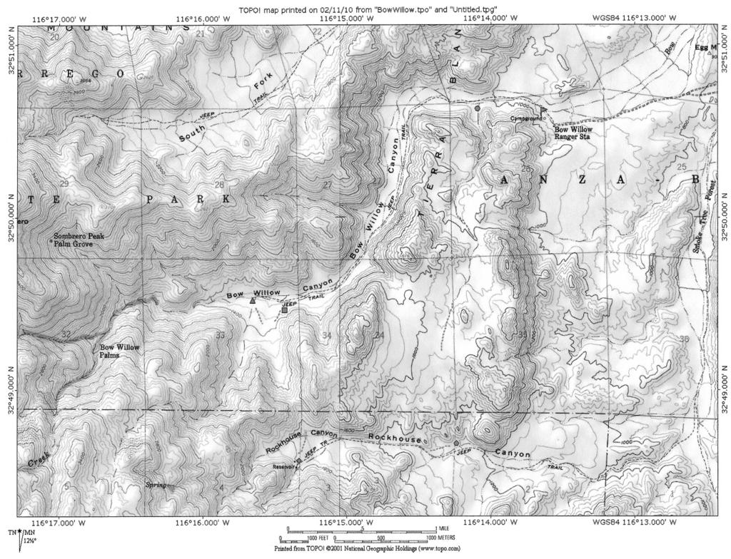
9 follow the wash/path north out of the parking area. Hike past the rock markers for the Surprise Canyon Trail and continue up the wash. You will soon reach North Grove. Allow time to stop and enjoy the scenery. To continue on to Mary s Grove, take the wash north, the right fork, thru North Grove. You will have to do some scrambling over rocks to get to Mary s Grove. After you find the grove, you can return the way you came, or plot a route across country into Surprise Canyon, then return to camp down Surprise Canyon from there. Surprise Canyon to Indian Canyon to Torote Canyon Start at the Day Use Parking and hike north up the wash on the trail to Surprise Canyon. A row of rocks in this wash that marks the Surprise Canyon Trail. Follow the trail left out of the wash, into Surprise Canyon and keep going on the trail through Surprise Grove and on up the canyon. When you are in site of Palm Bowl Grove, look right to see the steep side canyon entering from the north. On the east/right wall of the canyon, rock ducks mark a steep eroded trail that takes you up the canyon to the pass. When you reach the pass, the trail crosses to the west side of the pass and into Indian Gorge. The path is well defined and heads west, joining the Indian Valley Jeep Road. Take note of where the trail meets the jeep road, it is not well marked. To reach Torote Canyon, hike east, down Indian Gorge for about ½ mile, where Torote canyon opens to the north. Explore up the canyon as far as you like. Look for elephant trees (Torote) as you hike the canyon. Backpacking: Mountain Palm Springs to Indian Valley This is a good training backpack trail that takes you up Surprise Canyon and over the pass to Indian Gorge. Once in Indian Valley, follow the left canyon wall and hike as far as you like. There are many good areas to camp. You may not see anyone else back here. For a longer backpack, follow the jeep road west to the junction, take the right fork and hike up north fork Indian Valley. At the end of the road there are campsites. In a wet year, water flows out the canyon, but then quickly disappears into the desert sand. Unless you have verified the stream is running, do not depend on it for a water source. BOW WILLOW CAMP & BOW WILLOW CANYON AREA Reference Map 6 pg 16 Coordinates mark Bow Willow Camp. Long./Lat X The Bow Willow Primitive Camp is located off Hwy S2 about 30 miles south of Scissors Crossing. The 1.3 mile dirt road to camp is marked with a brown sign a few hundred feet before the turn. The camp has 16 family camp sites, allowing a maximum of 8 occupants, and a pit toilet and running water are available. The camp is popular on spring weekends and is first come first serve. Cost is $15.00 per night. I recommend this camp for patrol sized groups. For larger groups, see Mountain Palm Springs. Hikes - * There is no reliable water in this area other than Bow Willow Camp * Mountain Palm Springs Hike is an easy to moderate hike 2.6 miles to 6 miles long. Near Camp Site 1, walk west out the end of the road to locate the trail marker post. There is a 1.3 mile hike to the Southwest Grove at Mountain Palm Springs. The trail is fairly easy to follow. You can stretch this into a 5+ mile adventure by hiking the loop around the palm groves in the Mountain Palm Springs area, then returning to Bow willow Camp by this trail. There is also a spur trail marked Torote that takes you on a.5 mile side hike to a grove of elephant trees. Anza Borrego Guide
10 Bow Willow Canyon Backpack Hike is an easy 6 mile roundtrip that is great for training backpacks. Near Camp Site 1, walk out the end of the road and locate the trail post. Continue walking west past the trail post, up Bow Willow Canyon. At about a mile the canyon bends to the south, continue up canyon. The hiking is better on the left/east side. After about a mile the canyon slowly bends back to the west, keep hiking on the left, now the south side of the canyon. If you are day hiking when you reach the area where the canyon bottom narrows and you can see a few tall palms ahead, you have gone almost 3 miles. The canyon gets rougher if you chose to explore further on. For the backpackers, there is a long wide sandy shelf above the main wash in this area that is good for camping. Make camp and explore up canyon. Bow Willow to Rockhouse Canyon is a moderate to strenuous 8 mile hike that is not recommended for beginners! Hikers should be experienced and in good shape! This trip is a backpack or a day long hike. Hikers have several chances to utilize a compass, and/or a GPS and trail finding skills. Near Camp Site 1, locate the trail post near the end of the road. Hike up Bow Willow Canyon for approximately ½ mile. On your left a small canyon opens up, and an old fence post marks where the rough trail heads up canyon. The Canyon quickly narrows and bends left. Follow the narrowing wash up. You will pass a lone palm tree. Above here the trail involves some route finding and scrambling as you ascend the wash for the next ¼ mile. The canyon then flattens out into a slow climbing and winding sandy wash that heads south across the plateau. Look for the old Foot Trail markers along the way. Follow the wash/trail for about 1 ½ miles. At this point the trail will ascend the left bank of the wash up a steep 20 foot high slope. There are rock ducks marking the trail at the top and bottom of the bank. From here find and follow the faint, sometime elusive, trail south. It is marked by rock ducks and an occasional Foot Trail marker. The trail reaches the top of a narrow wash and quickly descends into Rockhouse Canyon. Some scrambling is required near the bottom of the canyon. The jeep road marked on the topo maps was washed out years ago. To hike to the Rockhouse turn right and hike up Rockhouse Canyon along the canyon wall. You may see an occasional rock duck. Hike up canyon thru the narrows and continue to where the canyon widens out. The cabin and reservoir are marked on the map. Continue southwest across the canyon and hike to the base of the ridge. If you find the old jeep road, it will take you to the Rockhouse. This was a cattleman s shack, back when cattle were grazed in this area. There are camping spots in the clear areas near the house, and to the left of the house is the old reservoir. To continue the hiking loop, hike due north from the Rockhouse, across the valley where a side canyon enters the main canyon. Ascend this wash up the canyon. About two thirds the way up the canyon, a rock duck trail can be found that will lead you to the pass. The trail descends into to Bow Willow Canyon dropping to the left. It is marked by occasional rock ducks. About half way down the trail gets vague. If you want to explore up Bow Willow Canyon, head straight for the main canyon. You can make camp here and explore up canyon more. If you camped at the Rockhouse and wish to return to your car, stay to the right side of the canyon as you walk towards Bow Willow Canyon. You may find some rock ducks marking a trail. Where you drop into the main wash, there should be a post marking a path down the steep bank. From here it is a 2.5 mile walk to your cars at the Bow Willow Primitive Camp. Map Symbols Flag is approximate location for Longitude/Latitude coordinates Triangles note possible trail camps. Circles, Squares, Diamonds note trail junctions or points mentioned in route description. Anza Borrego Guide
11
12
13
14
15
16
(west) onto Charleston Boulevard. Drive 16 miles on Charleston and turn right into Red Rock
 onto Charleston Boulevard. Drive 16 miles on Charleston and turn right into Red Rock") Hike: North Peak and Ice Box Overlook up and back Trailhead: 2.5 miles up the Rocky Gap Road not mark Distance: 5 miles round trip Elevation gain: 2,694 feet Elevation Peak: 7,094 feet Time: 3 to 5 hours
Hike: North Peak and Ice Box Overlook up and back Trailhead: 2.5 miles up the Rocky Gap Road not mark Distance: 5 miles round trip Elevation gain: 2,694 feet Elevation Peak: 7,094 feet Time: 3 to 5 hours
beach. Make the ford and follow the trail out to the junction with Red Creek Tr in an open grassy area.
 Description: This is a moderate to slightly strenuous 22.8 mile backpack (add 2.6 miles if you do the packless out and back to the Lion s Head) that will have you exploring nearly every thing that is The
GOLDEN EARS PROVINCIAL PARK
 GOLDEN EARS PROVINCIAL PARK Trail Information as of October 10 th 2015 Do not underestimate the mountainous wilderness of Golden Ears Provincial Park. The combination of rugged terrain and rapidly changing
DOGS ARE NOT PERMITTED ON TRAILS OR TOURS
 Tuesday, January 1, 2008 9:00 a.m. Hike Voices, Visions, and Views of Alcoholic Pass 3 Hours Hike Alcoholic Pass! Experience and discover the prehistory, history, and present day journey of those who have
Hiking Las Vegas.com
 Hike: Mt. Wilson via First Creek Canyon route Trailhead: First Creek marked Distance: 10 miles up and back Elevation gain: 3,400 feet Elevation of Peak: 7,070 feet Time: 7 to 9 hours (up and back) Difficulty:
Trail Beginning Elevation: 7553 ft The Poison Creek Trailhead is located at the end of National Forest Road 646E (NF-646E).
.") West Mountain Trails Poison Creek Trail #134 Length: 2.9 miles (4.7 km) Difficulty Horseback: A good trail for the first time west mountain rider, some steep sections Hiking: Most Difficult USGS Maps:
West Mountain Trails Poison Creek Trail #134 Length: 2.9 miles (4.7 km) Difficulty Horseback: A good trail for the first time west mountain rider, some steep sections Hiking: Most Difficult USGS Maps:
Section 7: Pick Up Where You Left Off! S-Tree Road over the Todd Road
 2018 TRACE NOTES Helpful information for your adventure on Section 7 of the Hiker Challenge. Start Point S-Tree Rd. End Point Intersection Todd Rd. / Hale Ridge Rd. WEATHER DECISION Weather Alert!!!! Potential
Trail Phasing Plan. Note: Trails in the Clear Creek Canyon area (Segments will be finalized in the future to minimize wildlife impacts
 Note: Trails in the Clear Creek Canyon area (Segments 2 5 and a future JCOS connection) will be finalized in the future to minimize wildlife impacts Trail Phasing Plan P Parking 3 Easy Trail Intermediate
Tiger Mountain State Forest:
 98 60 hikes within 60 miles: SEATTLE 20 Tiger Mountain State Forest: West Tiger Mountain Three Loop i KEY AT-A-GLANCE INFORMATION Length: 5.1 miles round-trip Configuration: Loop Difficulty: Moderate difficult
Stein Valley Nlaka pamux Heritage Park
 Stein Valley Nlaka pamux Heritage Park - Trail Information Update and Winter Advisory November 2017 March 2018 Welcome to Stein Valley Nlaka pamux Heritage Park! **This trail update is to inform park users
Hike at Pico Blanco Labor Day Weekend!
 Hike at Pico Blanco Labor Day Weekend! The Pico Blanco Hymn Here among the trees majestic Pleasures you will find On the trails of Pico Blanco With your friends and mine Trail the Eagle ever onward This
Marilla Reservoir to Chestnut Ridge via Marilla Trails and Bullis Hollow Trail east to west
 USGS topographic maps useful to this hike are the Bradford and Stickney 7.5 minute sectionals. These notes are designed to assist in identifying distance and location using geophysical and man-made characteristics
Hiking Trail Descriptions
 Hiking Trail Descriptions For ye shall go out with joy. And be led forth with peace. The mountains and the hills shall break forth before you in singing. And all the trees of the fields shall clap their
CIEC 9 PEAKS AWARD SUPPLEMENT POSSIBLE ROUTES FOR THE 9 PEAKS AWARD TRIP
 CIEC 9 PEAKS AWARD SUPPLEMENT POSSIBLE ROUTES FOR THE 9 PEAKS AWARD TRIP As you plan your trip, be aware of 3 regulations in this wilderness: 1. Camp only in designated campsites. 2. No campfires allowed.
Victoria Falls Lookout to Blue Gum Forest
 Victoria Falls Lookout to Blue Gum Forest 8 hrs Experienced only 13.8 km One way 5 112m This long day-walk follows a remote track down from Victoria Falls lookout, passing the waterfall, and into the Grose
UTAH S NATIONAL PARK TOUR
 UTAH S NATIONAL PARK TOUR DAY 1 Each client needs to check in any time at the fabulous Aria Hotel located in the heart of Las Vegas. We will meet at 6pm for a one hour orientation explaining the schedule
Congewai Track Head (East) to Watagan Headquarters
 to Watagan Headquarters") Congewai Track Head (East) to Watagan Headquarters 7 hrs Hard track 17.2 km One way 4 973m This full day walk starts from the Congewai valley trackhead (east) and follows the Great North Walk up into the
Congewai Track Head (East) to Watagan Headquarters 7 hrs Hard track 17.2 km One way 4 973m This full day walk starts from the Congewai valley trackhead (east) and follows the Great North Walk up into the
playwinterpark.com Off The Beaten Path Hikes Hiking Recommendations for the Adventurous Hiker
 playwinterpark.com Off The Beaten Path Hikes Hiking Recommendations for the Adventurous Hiker Hike: Devil s Thumb (difficult) Length: 3.93 miles one-way Elevation: Trailhead 9609 Destination 12,236 Trailhead
BRYCE CANYON COUNTRY Boulder Mountain Scenic backways itinerary
 BRYCE CANYON COUNTRY Boulder Mountain Scenic backways itinerary Boulder Mountain Area The high plateaus of the Aquarius Plateau (Boulder Mountain), are heavily forested and covered in countless winding
Charnley Explorer June 24 - July 15, 2018 Bachsten Creek and the Charnley River. Second draft: 14 November 2017
 Charnley Explorer June 24 - July 15, 2018 Bachsten Creek and the Charnley River. Second draft: 14 November 2017 The best part of the original section one is now part of out Gibb Road Gorges trip. The dates
CONTENTS. 31 THE TRAILS See next page for a complete listing of all trails and a locator map. Trail descriptions begin on page 31.
 CONTENTS Page Topic 6 Trail List 7 Trail Locator Map 8 Trails Listed by Dificulty 9 Trail Ratings Deined 11 INTRODUCTION 11 Using this Book 12 The Right Trail for You 13 About Moab 15 Utah OHV Laws and
Camp Geronimo Rainbow Trails
 Camp Geronimo Rainbow Trails With over 5,000 acres of surrounding national forest, the possibilities of getting out and seeing the wilderness are almost limitless. Camp Geronimo offers some of the greatest
Camp Jack Wright PERMANENT ORIENTEERING COURSE (2004)
") Camp Jack Wright PERMANENT ORIENTEERING COURSE (2004) WHAT IS ORIENTEERING? The skill which enables a person to navigate with a map. In the competitive sport, the winner is the person who finishes in the
Camp Jack Wright PERMANENT ORIENTEERING COURSE (2004) WHAT IS ORIENTEERING? The skill which enables a person to navigate with a map. In the competitive sport, the winner is the person who finishes in the
Telluride-to-Moab Alternative Singletrack Options
 Telluride-to-Moab Alternative Singletrack Options Day 1 Day 1 Alternate 1: Galloping Goose to Deep Creek. 18.4 miles, ascent 3,530ft, descent 1,388ft. This is fun, flowey, moderate to intermediate singletrack
Note: Coordinates are provided as Universal Transverse Mercator UTM Zone U21, North American Datum 1983 (NAD 83).
.") Northern Traverse Route Description The Northern Traverse (formerly the North Rim Traverse) is an unmarked and rugged backcountry hiking route. It is known be a demanding hike, because of its terrain and
Northern Traverse Route Description The Northern Traverse (formerly the North Rim Traverse) is an unmarked and rugged backcountry hiking route. It is known be a demanding hike, because of its terrain and
Mazatzal Wilderness Trail Maintenance and Exploration
 Mazatzal Wilderness Trail Maintenance and Exploration March 15-19 (Wednesday - Sunday) Difficulty: Beginner Camping: Car Camping Mileage: Wednesday ~4 miles Thursday ~4-6 miles Friday ~4-6 miles Saturday
Matthiessen State Park Dells Area Hike
 90 Easy Hikes Close to Home At the south end of the hike, you ll climb on top of a mound left over from a former coal-mining operation in the park. Not far from Goose Lake Prairie, the town of Morris hosts
DOGS ARE NOT PERMITTED ON TRAILS OR TOURS
 Saturday, March 1, 2008 1:00 p.m. Hike - Roving Naturalist in Borrego Palm Canyon 4 Hours Volunteer Naturalist Paul Larson will be roaming the Borrego Palm Canyon Trail searching for bighorn sheep and
Other Agencies and Organizations
 Daniel Boone National Forest 1700 Bypass Road WInchester, KY 40391 859-745-3100 Location Northern terminus is near Morehead, Kentucky. Southern terminus is located in the Big South Fork NRRA in Tennessee.
Camelback High Adventure Backpacking Award
 Trek Aid 103 Camelback High Adventure Backpacking Award High Adventure Team San Diego - Imperial Council Boy Scouts of America Page Intentionally Left Blank Trek Aid 103 Camelback High Adventure Backpacking
The temperature is nice at this time of year, but water is already starting to be scarce.
 In March of 2003, Scott Morrison and I went backpacking in the Grand Canyon. The temperature is nice at this time of year, but water is already starting to be scarce. Another issue with this time of year
CAMELBACK MOUNTAIN: CHOLLA TRAIL
 CITY OF PHOENIX :: Camelback Mountain: Cholla T rail 21 CAMELBACK MOUNTAIN: CHOLLA TRAIL IN BRIEF Camelback Mountain is the tallest point in the city of Phoenix. From the 2,704-foot summit of Camelback,
Beaver Creek State Park
 GENERAL INFORMATION Name of Park/Forest/Facility: Beaver Creek State Park County: Columbiana (St. Clair Township) Address: 12816 Sprucevale Road (ie County Rd 428) (street #, city) East Liverpool, Ohio
Stephens State Park Trails
 TRAILS OF ALLAMUCHY MOUNTAIN & STEPHENS STATE PARKS Allamuchy Mountain and Stephens State Parks contain 28 marked trails providing access to diverse landscapes for walking, hiking, biking, bird-watching,
Abbotts Falls Walking Track
 Abbotts Falls Walking Track 3 hrs 7.3 km Circuit Hard track 329m This circuit takes you through both dry and moist forest, using a combination of walking trails and wider tracks. The side trip to the dammed
Central Overland Trail Utah & Nevada Driving Guide, First Edition, 2016
 Central Overland Trail Utah & Nevada Driving Guide, First Edition, 2016 Page 51 In the third paragraph, second sentence, change 0.4 miles to 0.1 miles. In the fourth paragraph, second sentence, change
Route #1) Mt. of the Holy Cross - North Ridge
 Mt. of the Holy Cross - North Ridge") Climbing 14ers can be very dangerous, please read the Mountaineering Safety Page and make sure you have a map+compass and can use them effectively, without the help of electronic devices. Route #1) Mt.
Climbing 14ers can be very dangerous, please read the Mountaineering Safety Page and make sure you have a map+compass and can use them effectively, without the help of electronic devices. Route #1) Mt.
Berowra Waters to Cowan Station
 Berowra Waters to Cowan Station 3 hrs 30 mins 7.2 km One way Hard track 597m This is a hilly walk out of the beautiful Berowra Waters valley to Cowan Station. There are many wide views across Berowra Creek
throu Booth Hill Green Belt
 s k r a p s l l u b m u r T Explore gh Geocaching throu Booth Hill Green Belt This was originally a concept to try and preserve some of the land in our town, without hurting the developers that are creating
Sunday / Monday - Osceolas
 AMC August 3, 2015 Sunday / Monday - Osceolas 0 1737 ft 2007, Appalachian Mountain Club. All rights reserved. Notes Created by AMC White Mountain Guide Online wmgonline.org 1 Distance Time Elev Change
Cherokee Hiking Club Trail Blurb
 Cherokee National Forest Trail #164 Distance: 6.2 miles Elevation Change: 2280 feet High Point: 3692 feet (Waucheesi Mountain) Low Point: 1412 feet (Wildcat Creek) Trail Rating: Moderately Strenuous (NW
County Line trail - Miller Peak to Little Navaho
 County Line trail - Miller Peak to Little Navaho 7-17-2008 This hike features a portion of the County Line trail in the Teanaway that receives extremely little use despite offering a spectacular ridge-run
San Luis Obispo. Bishop Peak Felsman Loop Eagle Rock Maino Open Space Poly Canyon Poly P Other Areas
 San Luis Obispo Bishop Peak Felsman Loop Eagle Rock Maino Open Space Poly Canyon Poly P Other Areas 1 JCT. ELEV. 72 400 00 0 FELSMAN LOOP GATE LOOP RIDGE 600 FENCE JCT. ELEV. 860 1000 1200 BISHOP PEAK
Lavic Jasper Field Trip
 Lavic Jasper Field Trip There are few places you can go and, once there, you park and step out of your vehicle and start collecting immediately. Lavic is one such place. In the bowl where our camping area
Black Hill Regional Park, Little Seneca Lake
 Black Hill Regional Park, ittle Seneca ake ittle Seneca ake, in Black Hill Regional Park, is a reservoir created after a previous drought struck the Washington area. The park is under Maryland-National
Erskine Creek via Pisgah Rock and Jack Evans
 Erskine Creek via Pisgah Rock and Jack Evans 4 hrs 30 mins 7.1 km Circuit Very experienced only 6 421m This walk visits some great lookouts and explores the lower section of Erskine Creek. Most of the
A Publication of Friends of Sleeping Bear Dunes
 A Publication of Friends of Sleeping Bear Dunes 2014, Friends of Sleeping Bear Dunes, P.O. Box 545, Empire, MI 49630 www.friendsofsleepingbear.org info@friendsofsleepingbear.org Learn more about the Friends
Rogue Gorge (Mt. Stella) Roadless Area-- T30S R3E (primarily in portions of Sections 23, 26, 33, 34 & 35)
 Roadless Area-- T30S R3E (primarily in portions of Sections 23, 26, 33, 34 & 35)") Rogue Gorge (Mt. Stella) Roadless Area-- T30S R3E (primarily in portions of Sections 23, 26, 33, 34 & 35) Rogue River-Siskiyou National Forest--High Cascades Ranger District Upper, higher elevation trail
Rogue Gorge (Mt. Stella) Roadless Area-- T30S R3E (primarily in portions of Sections 23, 26, 33, 34 & 35) Rogue River-Siskiyou National Forest--High Cascades Ranger District Upper, higher elevation trail
C E N T R A L C A T S K I L L S
 120 C E N T R A L C A T S K I L L S Central Catskills Once out of the southern parts of the Catskills, the Long Path enters the more well traveled and civilized regions. The trail joins the Devil s Path,
Water Cache Guidelines, Maps & Driving Directions
 Water Cache Guidelines, Maps & Driving Directions Fall 2017 Water Cache Guidelines on the Oregon Desert Trail Anyone planning to use the Oregon Desert Trail (ODT) is responsible for providing their own
Non-motorized Trail Plan & Proposal. August 8, 2014
 Town of Star Valley Ranch, Wyoming and the Star Valley Ranch Association in partnership with the USDA Forest Service, Bridger-Teton National Forest, Greys River Ranger District Non-motorized Trail Plan
Route #2) Mt. Massive - Southwest Slopes
 Mt. Massive - Southwest Slopes") Route #2) Mt. Massive - Southwest Slopes Difficulty: Class 2 Ski: Advanced, D6 / R2 / III Exposure: Summit Elevation: Trailhead Elevation: Elevation Gain: Round-trip Length: Trailhead: County Sheriff:
Route #2) Mt. Massive - Southwest Slopes Difficulty: Class 2 Ski: Advanced, D6 / R2 / III Exposure: Summit Elevation: Trailhead Elevation: Elevation Gain: Round-trip Length: Trailhead: County Sheriff:
Crystal Lake Area Trails
 Lake Area Trails Welcome to the Lake area of the Big Snowy Mountains! This island mountain range in central Montana features peaks reaching to 8,600 feet and long, high ridges from which vistas of the
Lava Mountain Trail Distance: Elevation Range: Trail Type: Difficulty: Season: Driving Distance: Driving Time: USGS Maps: Pros Cons
 Lava Mountain Trail Distance: 13.4 miles (including the side trip to North Star Lake) Elevation Range: 5900'-8330' Trail Type: singletrack Difficulty: moderate Season: late June-October Driving Distance:
Oceano Dunes SVRA (Pismo Beach)
") SCLR Event Oceano Dunes SVRA (Pismo Beach) September 19-20, 2009 When: Where: What: September 19 nd and 20 th Oceano Dunes SVRA Pismo Beach, California Sand Dunes, camping, games, food, driving challenges,
SCLR Event Oceano Dunes SVRA (Pismo Beach) September 19-20, 2009 When: Where: What: September 19 nd and 20 th Oceano Dunes SVRA Pismo Beach, California Sand Dunes, camping, games, food, driving challenges,
Friday October 3. Lower Javelina Trail - Level D. about 3 miles, less than 500. Hike Contact: Joel Tormoen
 Friday October 3 Lower Javelina Trail - Level D. about 3 miles, less than 500 Hike Contact: Joel Tormoen joeltormoen@gmail.com Depart WB trailhead 8:00 am - return before 11:00 am This quite easy hike
Witte Museum Tour Meyers Spring Ranch Tour Saturday, September 1, a.m. - 4 p.m.
 Witte Museum Tour Meyers Spring Ranch Tour Saturday, September 1, 2018 10 a.m. - 4 p.m. This tour is limited to 35 participants (Ages 12 and up) All minors must be accompanied by a parent or legal guardian.
Arches of the. Sandflats Area. By Virginia Allen
 Arches of the Sandflats Area By Virginia Allen TABLE OF CONTENTS Introduction Dedication Road Log Arches 1. Perforated View Arch 2. Fee Booth Arch 3. Windsong Arch 4. Weird Arch 5. Resting Arch 6. Bike
HORSEBACK RIDING. All rates are subject to service charges
 HORSEBACK RIDING The Local Loop Ride - A family-friendly 45-minutes to one hour ride around Dunton s east property. Perfect for children and adults who are new to riding. Easy terrain and beautiful views.
Bradshaw Trails Series
 Bradshaw Trails Series Curtis James Troop 7014 Curtis.James@erau.edu My Motto: Never get lost! Hiking Rules Bradshaw Hiking Patch Series Hiking Tools Hiking Rules Hiking Merit Badge* Take five 10-mile
Beaver Country Trails ATV Jamboree
 Beaver Country Trails ATV Jamboree #1 Lincoln Mine Intermediate (Open to all ATVs/UTVs) 34 Miles Highlights: This ride will highlight the historic Lincoln Mining District, the first lead mine in Utah,
MONTANA ROCKHOUNDING MONTANA: 4 DAYS. Calgary Rock and Lapidary Club - You Drive Field Trip. A Rockhounder s Dream
 Calgary Rock and Lapidary Club - You Drive Field Trip MONTANA A Rockhounder s Dream ROCKHOUNDING MONTANA: 4 DAYS Crystal Park, Calvert Mine, Argo Mine Just a few hours south of Calgary is Montana, the
Scenic Railway to Ruined Castle
 Scenic Railway to Ruined Castle 7 hrs 30 mins 12.4 km Return Hard track 4 963m This is a very popular, full day walk, in the Katoomba Area, offering great views of the valley. The walk follows the edge
Cannon Traverse via Lonesome Lake - Hi Cannon - Kinsman Ridge
 AMC April 28, 2010 Cannon Traverse via Lonesome Lake - Hi Cannon - Kinsman Ridge 0 1673 ft 2007, Appalachian Mountain Club. All rights reserved. Notes Created by AMC White Mountain Guide Online wmgonline.org
Mt Kuring-gai Track to Berowra station
 Mt Kuring-gai Track to Berowra station 4 hrs 15 mins 9.7 km One way Hard track 4 553m This walk explores three valleys, with great displays of wild flowers in spring, and some nice sandstone overhangs.
Southern Utah University Hike Brochure
 Southern Utah University Hike Brochure Taylor Creek Trail Twenty minutes from Cedar City Red Hollow An hour and a half from Cedar City Fees: Entrance fee to Kolb Canyon Length: 5 miles round trip Length:
Tumbler Ridge Global Geopark
 Tumbler Ridge Global Geopark WILDERNESS WATERFALLS These waterfalls are in remote locations, no trails exist, and GPS is required. Not every geosite needs a hiking trail. Providing ready access to all
Slad over to Pitchcombe and back
 The walk climbs up from Slad over Wickridge Hill, descends to near Pitchcombe, then climbs back over Wickridge hill and round the back of Slad. Page 1 Start Point: SO 8718 0732 The Woolpack, Slad Length:
Pocahontas Area Map Jasper INFORMATION CENTRES Lake Louise Field Golden Banff
 Pocahontas Miette Hot Springs Area Map Jasper Maligne JASPER Columbia Icefield Saskatchewan River Crossing INFORMATION CENTRES Banff National Park Louise Kootenay Park Lodge Yoho National Park Columbia
Little Grand Canyon near Pomona, Illinois
 Little Grand Canyon near Pomona, Illinois Below: View of the trail and the terrain created using the Map My Hike app Below: Summary of the hike created using the Map My Hike app Presented by: Jennifer
Kakadu Highlights No. 9: September 23 - October 6, 2018
 Kakadu Highlights No. 9: September 23 - October 6, 2018 Section 1: Barramundi Creek: September 23-26 We begin with a four to six hour, 350 kilometre drive from Darwin. The last 45 kilometres is on a 4WD
Nature Track. 900m. 789m. 2 hrs 3.1 km Circuit. Hard track 238m. Blue Mountains National Park
 Nature Track 2 hrs 3.1 km Circuit Hard track 238m Largely following the ridges around the top edge of Wentworth Falls, this track is incredibly beautiful. After taking in the great views at Edinburgh Castle
ROAD SCHOLAR SPRING HIKING ADVENTURE Tentative Schedule April 9-14, 2017
 ROAD SCHOLAR SPRING HIKING ADVENTURE Tentative Schedule April 9-14, 2017 Sunday, April 9 PM 3:00-5:00 Arrival, registration and move in to the dorm. 6:00 Supper EVE 7:15 Welcome & Orientation, Sign Ups
1. Drive to Lake Cowichan via Highway 18 (which connects to the Trans-Canada Highway just north of Duncan)
") Driving Instructions to the Walbran Valley via Lake Cowichan (updated July 2018) 1. Drive to Lake Cowichan via Highway 18 (which connects to the Trans-Canada Highway just north of Duncan) 2. At the traffic
Driving Instructions to the Walbran Valley via Lake Cowichan (updated July 2018) 1. Drive to Lake Cowichan via Highway 18 (which connects to the Trans-Canada Highway just north of Duncan) 2. At the traffic
TREK THE ROCKIES ABOUT THE CHALLENGE TREK THE ROCKIES FOR HIGHLAND HOSPICE CANADA TREK DEMANDING
 TREK THE ROCKIES CANADA TREK DEMANDING ABOUT THE CHALLENGE The Canadian Rockies are justifiably world-famous for their magnificent scenery: the combination of impressive, jagged mountains, bright turquoise
HEADQUARTERS WEST LTD. CATTLE RANCHES HORSE PROPERTIES RURAL REAL ESTATE
 Aravaipa Creek Flowing Through the Property Offered for sale exclusively by: Sandy Ruppel Headquarters West, Ltd. PO BOX 542 Sonoita, AZ 85637 Phone (520) 444-1745 sandy@headquarterswest.com www.headquarterswest.com
Enterprise Reservoir. Pine Valley Mountain
 If you know of locations not listed below, please add to this list. This will helps to know what are the campsites and what to expect. Also, please make corrections and notes of your camps to help others.
Witte Museum Tour Painted Shelter on the Rio Grande River Saturday June 2, :30 A.M. 3:00 P.M.
 Witte Museum Tour Painted Shelter on the Rio Grande River Saturday June 2, 2018 9:30 A.M. 3:00 P.M. This tour is limited to 35 participants (Ages 12 and up) All minors must be accompanied by a parent or
Bonaqua Mountain Hardware Action Sprint 2013 Discovery Bay,Lantau The Course Route
 Bonaqua Mountain Hardware Action Sprint 2013 Discovery Bay,Lantau The Course Route The start is inside the Discovery Bay plaza and leads out to the main sandy beach where you will run to the end of the
Skiing and Snowshoes on Un-groomed Fernan Saddle Terrain
 Skiing and Snowshoes on Un-groomed Fernan Saddle Terrain Three ski or snowshoe routes are available from the Fernan Saddle Parking Lot which either do not cover routes ordinarily groomed for snow machine
1. Waterfall Gully Mt Lofty. 5 Of the Best Hikes in Adelaide
 Adelaide is a beautiful city, and one of the most incredible things about Adelaide is the quality of bushwalking available on the suburban fringe. It is surrounded by the Mt Lofty Ranges, and much of the
Central Alberta Mountain Club 2017 Trip Schedule
 Central Alberta Mountain Club 2017 Trip Schedule Date Trip Trip Coordinator Type Distance Elevation Time # participants April 3, 6, 10, 13, 20 Spring Fling Exercise Thing Activities start at 6:30 pm ending
SDTrucksprings. Arkansas Off-roading/4x4 Guide Copyright 2015 We Specialize In:
 SDTrucksprings Arkansas Off-roading/4x4 Guide Copyright 2015 We Specialize In: Helper Springs Air Bags Leaf Springs Body Lift Kits Coil Springs Timbren Kits Hellwig Springs Lift Blocks And More! Visit
Staunton River Trail to Hoover Camp and Fork Mtn. Relay Tower (Based on September 18, 2013 hike by Ron Singleton, Fredericksburg, Va.
 Staunton River Trail to Hoover Camp and Fork Mtn. Relay Tower (Based on September 18, 2013 hike by Ron Singleton, Fredericksburg, Va.) The President's Cabin (The "Brown" House) at Camp Hoover. Sign on
Dadder Cave and Jack Evans track
 Dadder Cave and Jack Evans track 2 Days 10.3 km Circuit Very experienced only 535m This fairly short overnight walk is a great way to explore Erskine Creek. The walking along Erskine creek is mostly off
Leaden Boot Challenge 2016 ROUTE INSTRUCTIONS
 Leaden Boot Challenge 2016 ROUTE INSTRUCTIONS Section 1 Alstonefield to Ilam (CP2) From the village hall car park turn R then L and pass through the village keeping to the R to enter Church Street. Pass
Wicklow Mountains Path Survey
 Wicklow Mountains Path Survey Glenmacnass Tonelagee Start to Finish: O 114 030 to O 085 016 Altitude (lowest highest): 370m 817m Weather: Sunny day, hot Access: Military Road, Glenmacnass Surveyed by:
Hole in the Rock Scenic Backway
 Hole in the Rock Scenic Backway The Hole in the Rock Scenic Backway leads one along the pioneer path created by a Mormon Expedition. Approximately 55 miles one-way from Highway 12 to the Hole-inthe-Rock,
Peak to Peak MST Segment 1A
 1 Mountains-to-Sea Trail Last Updated 1/1/2017 Peak to Peak MST Segment 1A View from the Mountains-to-Sea Trail at Clingmans Dome Photo by Danny Bernstein CLINGMANS DOME TO WATERROCK KNOB ALTERNATE ROUTE
CWMGIEDD FROM ABERCRAVE
 Abercrave to Cwmgiedd Walk Page 1 Starting from The Abercrave Inn. Grid Ref: SN 824128 From the Abercrave Inn, an 11.3km (7 miles) walk to the foothills of the Cribarth Mountain, then through forest to
Oregon Section B - Page m
 Oregon Section B - Page 1 5 35000m 5 36000m 5 37000m 5 38000m 46 57000m 46 58000m Hwy5B - Interstate Highway 5 - mi 1716.4-4271 ft RD1717 - PCT departs paved Old Highway 99 - mi 1716.8-4357 ft PL1717 -
Saturday Hike - Hancock Loop & Out
 AMC August 3, 2015 Saturday Hike - Hancock Loop & Out 0 2487 ft 2007, Appalachian Mountain Club. All rights reserved. Notes Created by AMC White Mountain Guide Online wmgonline.org 1 Distance Time Elev
HENRY ROWE SCHOOLCRAFT TRAIL
 HENRY ROWE SCHOOLCRAFT TRAIL This map and compass trail may be divided into north and south loops. The South Loop is about 9 miles in length while the North Loop is about 5 miles. Many hiking options are
Bell s Travel Guides
 Bell s Travel Guides Top of the World Highway Road Log Mile by Mile Description of the Top of the World Highway so you always know what lies ahead. Dawson City, Yukon to Tetlin Junction on the Alaska Highway
Merritts Traverse. 1928m
 Merritts Traverse 3 hrs Hard track 5.8 km Circuit 4 167m This walk starts with a scenic journey to the top of the hill on the chairlift. Starting along Merritts Nature walk, this walk soon detours down
Location: Height: Access: Distance: Elevation: Season: Difficulty: Lat/Long: Directions:
 Upper Eagle Falls Upper Eagle Falls (~20 ft.) is a short hike up from the roadside at the Eagle Falls picnic area. It is very difficult to get a parking spot here during the day, so it is recommended to
LAS VARAS RANCH CA COASTAL TRAIL PROPOSED ALIGNMENT
 LAS VARAS RANCH CA COASTAL TRAIL PROPOSED ALIGNMENT Santa Barbara Trails Council * Prepared by Ray Ford February 1,2012 The following notes accompany the Santa Barbara Trails Council map for the Las Varas
California Section C - Page 1
 - Page 1 5 2m 5 2m 5 0m 5 3m 37 0m These maps are provided as a free service to PCT hikers. I believe the information is accurate but they may contain errors. The maps are distributed in the hope that
Victoria Falls and Grose Valley to Blackheath Station
 This walk explores a fantastic section of the Grose Valley. Starting above Victoria Falls, the walk explores the cascades before dropping into the valley for the first nights rest at Burra Korain campsite.
Wentworth Pass. 893m. 535m. 4 hrs. Hard track 5.1 km Circuit. 692m
 Wentworth Pass 4 hrs Hard track 5.1 km Circuit 4 692m This walk offers a great way to explore the magical, upper section of the Valley of the Waters. The walk starts and finishes at Conservation Hut, which