Erskine Creek via Pisgah Rock and Jack Evans
|
|
|
- Toby Peters
- 5 years ago
- Views:
Transcription


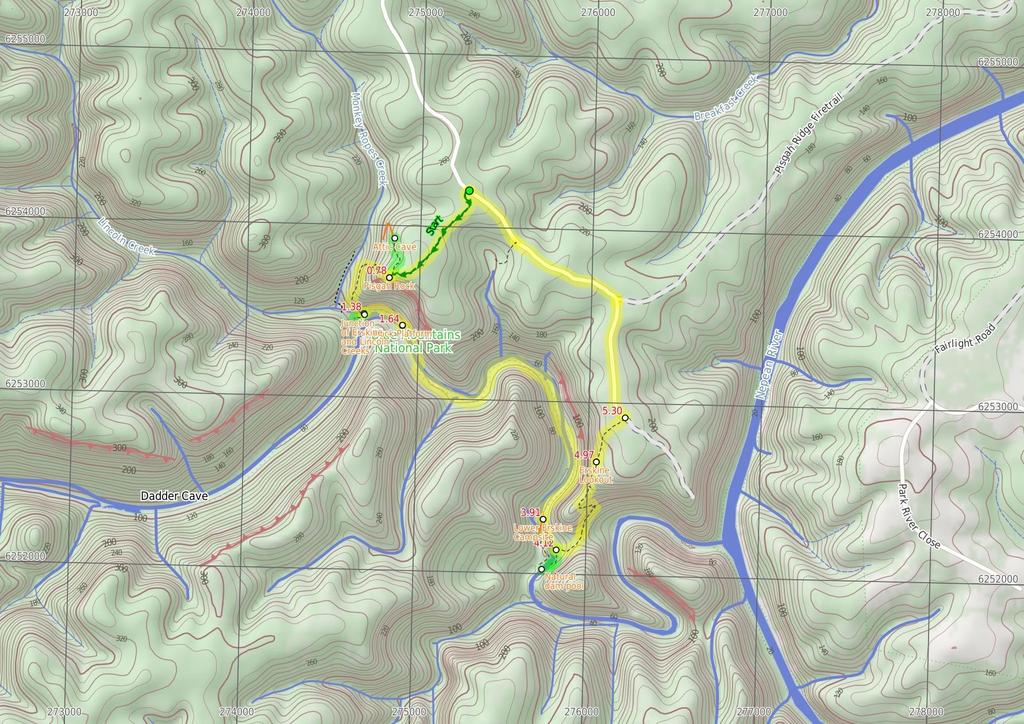
1 Erskine Creek via Pisgah Rock and Jack Evans 4 hrs 30 mins 7.1 km Circuit Very experienced only 6 421m This walk visits some great lookouts and explores the lower section of Erskine Creek. Most of the walk along Erskine Creek is off track and the bush is quite thick in places. A great walk for people wanting to explore a remote area of the lower Blue Mountains National Park. You could make this an overnight walk and stay at Lower Lincoln Creek campsite. 271m 38m Blue Mountains National Park Maps, text & images are copyright wildwalks.com Thanks to OSM, NASA and others for data used to generate some map layers.

2 Attic Cave Before You walk Attic Cave, near Pisgah Rock in the lower blue mountains is a large sandstone overhang. The cave has been used by walkers as an overnight camp for many decades. The cave could comfortably sleep about 5 people. There is a log book in a tin cake box on the rock shelf, making for some interesting reading, and awaiting your story. There is a fire circle, and the cave is reasonably well protected from the weather. The name Attic Cave is said to have come from the hole, a shelf, in the top of the cave, forming an attic. Bushwalking is fun and a wonderful way to enjoy our natural places. Sometimes things go bad, with a bit of planning you can increase your chance of having an ejoyable and safer walk. Before setting off on your walk check Pisgah Rock Pisgah Rock, is a short walk from Nepean Lookout Fire Trail in the lower Blue Mountains, and provides excellent views up Erskine Creek Gorge. The informal lookout is not fenced, and the surface is uneven with large crevasse like cracks. The view is simply amazing, with great views right up the middle of Erskine Creek Gorge. There are also great views to the left, down Erskine Creek Gorge and across the flats of the southern parts for greater Sydney. The rock presumably derives its name from the height point on Mount Nebo, where the Bible reports Moses seeing the promised land for the first time. In Hebrew pisgah refers to a high place. This Pisgah Rock is very much a high place, with great views. Junction of Erskine and Lincoln Creeks The junction of Erskine and Lincoln Creeks, in the Blue Mountains National park, occurs at a large rock platform. The rock platform contains many water holes, a few large square boulders and a few short cascades. There are breath taking views up looking Erskine Creek Gorge. Looking up to the escarpment, to the north east, there is a view of Pisgah Rock. This area floods after rain, but when water levels are normal, this can be a lovely place to rest and enjoy the creeks and gorge. Rock Platform This is a rock platform on Erskine creek about 200m downstream from the junction with Lincoln Creek. The area does flood so depending on water levels this is usually a large rock platform with some interesting water holes, and a lovely cascade flowing into a shallow pool. Although this lacks the majestic view up Erskine Creek (found a short distance upstream), this spot does provide an open spot, great for a snack, lunch and to rest. 1) Weather Forecast (BOM Central Tablelands District) 2) Fire Dangers (Greater Sydney Region) 3) Park Alerts (Blue Mountains National Park) 4) Research the walk to check your party has the skills, fitness and equipment required 5) Agree to stay as a group and not leave anyone to walk solo Think before you TREK The 'Think before you TREK' program developed by NSW Police & NPWS promotes the benefits of planning ahead for your bushwalking trip by using an easy to remember acronym: adequate supplies of food, water, navigation and first T Take aid equipment. your planned route and tell friends and family when R Register you expect to return. beacon (PLB's) should be carried on walks with E Emergency significant gaps in mobile coverage (check terrain profile). to your planned route and follow the map and walking K Keep trails. Topo Maps The maps provided on wildwalks are helpful, but there are times where you may need maps covering a broader area. Maps that cover this walk include; 1: Map Series:90303N PENRITH 1: Map Series:9030 PENRITH Grade This walk has been graded using the AS The overall grade of the walk is dertermined by the highest classification along the whole track. 6 Grade 6/6 Very experienced only Length 7.1 km Circuit Time 4 hrs 30 mins Quality of track Off track (no visible track at times) (6/6) Signs No directional signs (5/6) Experience Required Very high level of bushwalking experience recommended (6/6) Weather Forecast, unforecast storms and severe weather may impact on navigation and safety (4/6) Infrastructure No facilities provided (5/6) * This walk passes through very remote areas and sections have no visible track. At least one person in your group should have training and experience in off track walking and navigation. Even with these notes and a GPS these extra skills and equipment are required.
3 Are you ready to have fun? Please ensure you and your group are well prepared and equipped for all possible hazards and delays. Check park closures, weather information and Fire Danger Rating before setting out. Optional side trips and alternate routes noted are not included in this walks overall grade, length or time estimate. Please allow extra time for resting and exploring areas of interest. The authors, staff and owners of wildwalks take care in preparing this information but will not accept responsibility for any inconvenience, loss or injury you may experience. Please take care, have fun - Happy Walking. Experainced walkers only: This walk passes through very remote areas and sections have no visible track. At least one person in your group should have training and experience in off track walking and navigation. Even with these notes and a GPS these extra skills and equipment are required. Getting there Traveling by car is the only practical way to get to Pisgah Rock track head (gps: , ). Car: A park entry fee is required for driving into the park. This is a circuit, so you will finish back at the start. Find up to date and more information inlcuding; travel directions, weather, park closures and walker feedback at 0 Pisgah Rock track head (760 m 14 mins) From the Pisgah Rock car park (2.2km further along Nepean Lookout Fire Trail from the Oaks Picnic Area), this walk follows the 'Pisgah Rock 700mt' sign along the old management trail. The track meanders through the Eucalypt and Casuarina forest as it climbs a gentle hill and then heads down the other side. The track soon comes to an intersection with a small bush track off to the left, from the intersection there are glimpses of the valley views Optional sidetrip to Attic Cave (250 m 6 mins) Turn right: From the intersection, the walk follows the old management trail that very soon narrows into a bush track as it heads away from the view (keeping the valley to the left). The tracks then emerges from the bush to cut across a rock shelf and into the scrub again. Once in the gully the track turns left to climb down the 'V' in the rock. At the bottom of the climb the walk heads right under the now obvious sandstone cave. The walk continues following the base of this cliff line along a fairly clear track passing several interesting sandstone overhangs. Soon the track comes to a large overhang and fire circle at Attic camping cave. At the end of this side trip, retrace your steps back to the main walk then Veer right Attic Cave Attic Cave, near Pisgah Rock in the lower blue mountains is a large sandstone overhang. The cave has been used by walkers as an overnight camp for many decades. The cave could comfortably sleep about 5 people. There is a log book in a tin cake box on the rock shelf, making for some interesting reading, and awaiting your story. There is a fire circle, and the cave is reasonably well protected from the weather. The name Attic Cave is said to have come from the hole, a shelf, in the top of the cave, forming an attic Pisgah Rock Intersection (20 m 1 mins) Veer left: From the intersection this walk takes the short bush track toward the view of the valley. The track comes to the unfenced cliff and great view from the top of Pisgah Rock and a sign posted 'take care when walking near cliffs' Pisgah Rock Pisgah Rock, is a short walk from Nepean Lookout Fire Trail in the lower Blue Mountains, and provides excellent views up Erskine Creek Gorge. The informal lookout is not fenced, and the surface is uneven with large crevasse like cracks. The view is simply amazing, with great views right up the middle of Erskine Creek Gorge. There are also great views to the left, down Erskine Creek Gorge and across the flats of the southern parts for greater Sydney. The rock presumably derives its name from the height point on Mount Nebo, where the Bible reports Moses seeing the promised land for the first time. In Hebrew pisgah refers to a high place. This Pisgah Rock is very much a high place, with great views Pisgah Rock (610 m 21 mins) Turn right: From the 'take care when walking near cliffs' signpost on Pisgah Rock this walk now follows the rock at the top of the cliff keeping the valley below to the left. After passing a couple of very steep looking cracks in the rock, the faint track comes to a much more gentle looking pass with a large Banksia growing out of it. The walk heads down through this pass. The track turns right and heads down a much steeper climb through the V in the rock. At the bottom of this climb the bush track leads to a small unfenced rock platform. The walk then turns right heading down the couple more climbs then turns left back under the rock platform. The track continues to wind down several more steep rocky climbs following a faint track and cairns. after most climbs the track generally tends left and down hill. After the last climb, the track heads away from the cliff making, tending left heading fairly steeply to an intersection near the junction of Erskine Creek and Lincoln Creek Optional sidetrip to Lower Lincoln Campsite (70 m 2 mins) Turn right: From the intersection, this walk cross Lincoln Creek at the rock pools staying upstream of the small cascade (this may be impassable after rain). On the other side of the creek the walk picks up a faint track heading gently up the ridge. Soon the track opens up into a large campsite with some wonderful grass trees. At the end of this side trip, retrace your steps back to the main walk then Veer right Junction of Erskine and Lincoln Creeks The junction of Erskine and Lincoln Creeks, in the Blue Mountains National park, occurs at a large rock platform. The rock platform contains many water holes, a few large square boulders and a few short cascades. There are breath taking views up looking Erskine Creek Gorge. Looking up to the escarpment, to the north east, there is a view of Pisgah Rock. This area floods after rain, but when water levels are normal, this can be a lovely place to rest and enjoy the creeks and gorge Junction of Erskine and Lincoln Creeks (260 m 7 mins) Continue straight: From the intersection, this walk head downstream along Erskine Creek, keeping the creek to the right. After following the indistinct bush track for a short while it leads to an large open rock platform. The walk continues along the rock until coming to the edge of a large pool at the bottom of the cascades Rock Platform This is a rock platform on Erskine creek about 200m downstream from the junction with Lincoln Creek. The area does flood so depending on water levels this is usually a large rock platform with some interesting water holes, and a lovely cascade flowing into a shallow pool. Although this lacks the majestic view up Erskine Creek (found a short distance upstream), this spot does provide an open spot, great for a snack, lunch and to rest Rock platform (2.3 km 51 mins) Veer left: From the end of the rock platform, the walk heads downstream initially by following the rock fall on the northern bank. There is a faint foot pad that lasts a short while. Find a good place to cross to the other bank (may be impassable after rain), where a rock shelf on the southern bank make walking easier. After passing the large gully the foot pad has all but disappeared, the walk continues down stream keeping the creek on the left. About half way along the large cliff high on the other side of the creek, the bank on the western side becomes difficult to pass due to another cliff. From here find a good place to cross (may be impassable after rain) and pick up the faint foot pad on the other side. The foot pad continues downstream (now with the creek on the right) and passes a few rock platforms at times. The track becomes more distinct as it gets closer to Jack Evans track. Not far before Jack Evans track the footpad comes to a small campsite with a fire circle on the left Lower Erskine Campsite A small campsite, just up from the eastern bank of Erskine Creek, a short distance north of where Jack Evans track crosses the creek. The campsite has a small fire circle, and enough space for one maybe two tents. Erskine creek is a handy water supply (treat before drinking) Lower Erskine Campsite (110 m 2 mins) Continue straight: From the campsite this walk heads down stream keeping the creek to the right. Following a faint bush track the walk soon comes to an intersection with the Jack Evans Track just above a small sandy beach Int of Jack Evans Track and Erskine Creek (100 m 2 mins) Turn left: From the intersection just above sandy beach on the creek, this walk follows the clear bush track away from the creek and up the gentle hill. The track soon turns right and follows the creek on the right, downstream for a little while. The track then tends left up hill passing through a tunnel of vegetation to emerge onto an intersection with the more distinct Jack Evans and lower Erskine tracks 4.12 Optional sidetrip to Eastern side of natural dam w (180 m 7 mins) Turn right: From the intersection, this walk follows the wider bush track down hill keeping the sound of Erskine Creek to the right, soon the creek is in view. The track soon fades to a become a less distinct bush track leading up the bank away from the creek. The track climbs to a large boulder providing great views of the pool in Erskine Creek. The track then leads down to the natural charcoal deposits and continues along the creek edge to the water depth indicators. (A remote monitoring box is visible up the hill). Veer left: From the water depth indicators this walk follows the creek down stream keeping Erskine Creek on the right. The faint bush track soon leads to the visible series of large boulders forming a natural dam wall. At the end of this side trip, retrace your steps back to the main walk then Veer right Natural dam pool A series of very large boulders have formed a natural dam on Erskine Creek, about 170m north of Big Crater Creek. The dam forms a large lovely pool upstream. The pool is used by Sydney Water for measurements, and a water depth indicator is bolted to the rock. The pools is not safe to dive or jump into, there are many submerged objects Int of Jack Evans and the lower Erskine tracks (850 m 31 mins) Veer left: From the intersection this walk follows the wider bush track up the hill past the large gum tree. The track then comes to, and climbs a series of timber steps up to a distinct saddle. The track continues gently up the hill for a short distance to come to an intersection with the faint short cut track off to the right. Continue straight: From the intersection this walk follows the wider bush track up the gentle hill. The track is narrow in places with a drop off to the right. The track then starts to climb the hill using a series of steps and switch
.")
4 backs to wind up through the wonderful sandstone outcrops. The track passes a few nice caves and through gaps in the rock. After the last steep section the track comes to a large rock platform on the left (with some great views). The track continues to follow the main path up the hill, and passes a long sandstone wall on the left of the track. Soon after this sandstone wall, the track comes to a wide sandy patch, with and unfenced rock platform and view on the left. This is the Erskine Lookout, an informal unfenced lookout Erskine Lookout This informal and unfenced lookout on Jack Evans Track is in the lower Blue Mountains south west from the end of Nepean Lookout Fire Trail. The lookout is perched high above Erskine Creek and provides wonderful view upstream, and good views downstream. The view down in to the gorge gives a unique perspective of the lower section of Erskine Creek Erskine Lookout (320 m 8 mins) Continue straight: From Erskine Lookout, this walk heads up the gentle hill, following the sandy track, keeping the view to the left. The track passes some informal tracks to the left, passes a burnt 'take care when walking near cliffs' sign, and continues up the hill getting a little steeper. The track then comes to a silver information sign about 'Jack Evans Track'. The track then bends left and comes to the car park at the end of the publicly accessible section of the Nepean Lookout Fire Trail. 5.3 Car park at end of Nepean Lookout fire trail (1.8 km 33 mins) Turn left: From the end of end of Nepean Lookout fire trail, this walk follows the road northward away from the locked gate initially keeping the car park to the left. The road soon comes to an intersection with Pisgah Ridge fire trail (a gated management trail on the right). Veer left: From the intersection, this walk follows Nepean Lookout fire trail north west around the left hand bend. The road soon comes to the Machins Crater car park. Continue straight: From the Machins Crater car park, this walk follows Nepean Lookout fire trail north west, up the hill, initially with Machins Crater track on the left. The road heads up the hill and soon comes the Pisgah Rock track head and car park.
5
6 Summary navigation sheet for the Erskine Creek via Pisgah Rock and Jack Evans km From Start Pisgah Rock track head , (GR Penrith, ) 0.76 Pisgah Rock Intersection , (GR Penrith, ) 0.76 Pisgah Rock Intersection , (GR Penrith, ) 0.78 Pisgah Rock , (GR Penrith, ) 1.38 Junction of Erskine and Lincoln Creeks , (GR Penrith, ) 1.38 Junction of Erskine and Lincoln Creeks , (GR Penrith, ) 1.64 Rock platform , (GR Penrith, ) 3.91 Lower Erskine Campsite , (GR Penrith, ) 4.02 Int of Jack Evans Track and Erskine Creek , (GR Penrith, ) 4.12 Int of Jack Evans and the lower Erskine tracks , (GR Penrith, ) 4.12 Int of Jack Evans and the lower Erskine tracks , (GR Penrith, ) 4.97 Erskine Lookout , (GR Penrith, ) 5.30 Car park at end of Nepean Lookout fire trail , (GR Penrith, ) Powered by TCPDF ( Up/Dwn Length Initial directions (Use full tracknotes and maps for more detail) m 14 mins 250 m 6 mins 20 m 1 mins 610 m 21 mins 70 m 2 mins 260 m 7 mins 2.3 km 51 mins 110 m 2 mins 100 m 2 mins 180 m 7 mins 850 m 31 mins 320 m 8 mins 1.8 km 33 mins From the Pisgah Rock car park (2.2km further along Nepean Lookout Fire Trail from the Oaks Picnic Area), this walk follows the 'Pisgah Rock 700mt' sign along the old management trail. Optional sidetrip to Attic Cave. Turn right: From the intersection, the walk follows the old management trail that very soon narrows into a bush track as it heads away from the view (keeping the valley to the left). Veer left: From the intersection this walk takes the short bush track toward the view of the valley. Turn right: From the 'take care when walking near cliffs' signpost on Pisgah Rock this walk now follows the rock at the top of the cliff keeping the valley below to the left. Optional sidetrip to Lower Lincoln Campsite. Turn right: From the intersection, this walk cross Lincoln Creek at the rock pools staying upstream of the small cascade (this may be impassable after rain). Continue straight: From the intersection, this walk head downstream along Erskine Creek, keeping the creek to the right. Veer left: From the end of the rock platform, the walk heads downstream initially by following the rock fall on the northern bank. Continue straight: From the campsite this walk heads down stream keeping the creek to the right. Turn left: From the intersection just above sandy beach on the creek, this walk follows the clear bush track away from the creek and up the gentle hill. Optional sidetrip to Eastern side of natural dam wall. Turn right: From the intersection, this walk follows the wider bush track down hill keeping the sound of Erskine Creek to the right, soon the creek is in view. Veer left: From the intersection this walk follows the wider bush track up the hill past the large gum tree. Continue straight: From Erskine Lookout, this walk heads up the gentle hill, following the sandy track, keeping the view to the left. Turn left: From the end of end of Nepean Lookout fire trail, this walk follows the road northward away from the locked gate initially keeping the car park to the left.
Dadder Cave and Jack Evans track
 Dadder Cave and Jack Evans track 2 Days 10.3 km Circuit Very experienced only 535m This fairly short overnight walk is a great way to explore Erskine Creek. The walking along Erskine creek is mostly off
Nature Track. 900m. 789m. 2 hrs 3.1 km Circuit. Hard track 238m. Blue Mountains National Park
 Nature Track 2 hrs 3.1 km Circuit Hard track 238m Largely following the ridges around the top edge of Wentworth Falls, this track is incredibly beautiful. After taking in the great views at Edinburgh Castle
Victoria Falls Lookout to Blue Gum Forest
 Victoria Falls Lookout to Blue Gum Forest 8 hrs Experienced only 13.8 km One way 5 112m This long day-walk follows a remote track down from Victoria Falls lookout, passing the waterfall, and into the Grose
Leura Cascades to Gordon Falls Reserve
 Leura Cascades to Gordon Falls Reserve 1 hr 15 mins 1.8 km One way Moderate track 200m From Leura Park to Gordon Falls Park, this diverse walk offers fantastic views of the Jamison Valley, as well as two
Guthega to Mt Twynam. 2183m. 1583m. 6 hrs 45 mins 14.8 km Return. Experienced only. 913m
 Guthega to Mt Twynam 6 hrs 45 mins 14.8 km Return Experienced only 5 913m This walk starts from Guthega and makes its way along the Snowy River to the Illawong Lodge, via the Blue Cow Creek flying fox.
Abbotts Falls Walking Track
 Abbotts Falls Walking Track 3 hrs 7.3 km Circuit Hard track 329m This circuit takes you through both dry and moist forest, using a combination of walking trails and wider tracks. The side trip to the dammed
Congewai Track Head (East) to Watagan Headquarters
 to Watagan Headquarters") Congewai Track Head (East) to Watagan Headquarters 7 hrs Hard track 17.2 km One way 4 973m This full day walk starts from the Congewai valley trackhead (east) and follows the Great North Walk up into the
Congewai Track Head (East) to Watagan Headquarters 7 hrs Hard track 17.2 km One way 4 973m This full day walk starts from the Congewai valley trackhead (east) and follows the Great North Walk up into the
Staples Lookout to Mt Wondabyne loop
 Staples Lookout to Mt Wondabyne loop 4 hrs 3 mins 1.8 km Circuit Hard track 337m This walk starts and finishes at Staples Lookout, on Woy Woy Rd. The walk follows sections of the Great North Walk around
Mt Kuring-gai Track to Berowra station
 Mt Kuring-gai Track to Berowra station 4 hrs 15 mins 9.7 km One way Hard track 4 553m This walk explores three valleys, with great displays of wild flowers in spring, and some nice sandstone overhangs.
Berowra Waters to Cowan Station
 Berowra Waters to Cowan Station 3 hrs 30 mins 7.2 km One way Hard track 597m This is a hilly walk out of the beautiful Berowra Waters valley to Cowan Station. There are many wide views across Berowra Creek
Merritts Traverse. 1928m
 Merritts Traverse 3 hrs Hard track 5.8 km Circuit 4 167m This walk starts with a scenic journey to the top of the hill on the chairlift. Starting along Merritts Nature walk, this walk soon detours down
Girrakool to Wondabyne station
 Girrakool to Wondabyne station 4 hrs Hard track 9.5 km One way 4 438m This walk starts from the Girrakool picnic area and winds south, through the Brisbane Waters National Park. The walk crosses some long
National Pass. 893m. 665m. 3 hrs 30 mins 4.6 km Circuit. Hard track 773m. Blue Mountains National Park
 National Pass 3 hrs 3 mins 4.6 km Circuit Hard track 773m 4 This walk offers fantastic views of the Jamison Valley and the surrounding cliffs. Take time to explore the historic and very scenic ledge halfway
Wentworth Pass. 893m. 535m. 4 hrs. Hard track 5.1 km Circuit. 692m
 Wentworth Pass 4 hrs Hard track 5.1 km Circuit 4 692m This walk offers a great way to explore the magical, upper section of the Valley of the Waters. The walk starts and finishes at Conservation Hut, which
Girrakool to Wondabyne station via Pindar caves
 Girrakool to Wondabyne station via Pindar caves 7 hrs 30 mins 18.1 km One way Experienced only 5 741m This walk starts from the Girrakool picnic area and winds south, following Piles creek into the Brisbane
Victoria Falls to Blackheath Station
 Victoria Falls to Blackheath Station 2 Days Experienced only 22.2 km One way 5 1561m This is a fantastic overnight walk with a sleep in Acacia Flats camping area. The Grose Valley, with its views of the
Scenic Railway to Ruined Castle
 Scenic Railway to Ruined Castle 7 hrs 30 mins 12.4 km Return Hard track 4 963m This is a very popular, full day walk, in the Katoomba Area, offering great views of the valley. The walk follows the edge
Berowra to Cowan via Berowra Waters
 Berowra to Cowan via Berowra Waters 6 hrs Hard track 12.9 km One way 4 884m With train station at each end this walk explores the ridges and valleys around Berowra Waters. There are plenty of excellent
Victoria Falls and Grose Valley to Blackheath Station
 Victoria Falls and Grose Valley to Blackheath Station 3 Days Experienced only 22.5 km One way 5 158m This walk explores a fantastic section of the Grose Valley. Starting above Victoria Falls, the walk
Main Range Track - Loop from Charlotte Pass camping near Mt Townsend
 Main Range Track - Loop from Charlotte Pass camping near Mt Townsend 2 Days Experienced only 27.7 km Circuit 5 1260m This great overnight walk starts from Charlotte Pass and provides access to some of
Crosslands to Berowra Waters return
 Crosslands to Berowra Waters return 6 hrs Hard track 13.7 km Return 4 1005m This return walk starts from the Crosslands Reserve and follows the Great North Walk along Berowra creek. The walk includes some
Jerusalem Bay Track (Cowan to Brooklyn)
") Jerusalem Bay Track (Cowan to Brooklyn) 5 hrs 30 mins 13.4 km One way Hard track 4 654m This Cowan to Brooklyn Station walk is a popular section of the Great North Walk, with scenery ranging from foreshore
Jerusalem Bay Track (Cowan to Brooklyn) 5 hrs 30 mins 13.4 km One way Hard track 4 654m This Cowan to Brooklyn Station walk is a popular section of the Great North Walk, with scenery ranging from foreshore
Gibberagong Track. 169m
 Gibberagong Track 2 hrs 30 mins 6.5 km One way Hard track 4 180m Starting in suburban Wahroonga, this wellmaintained track follows Cockle Creek down to Bobbin Head in the Ku-ring-gai Chase National Park.
Main Range Walk - Charlotte Pass to Mount Kosciuszko
 Main Range Walk - Charlotte Pass to Mount Kosciuszko 9 hrs Hard track 21.9 km Circuit 4 920m This full day walk explores some of the greatest alpine country on offer in NSW. The walk grants views of Blue,
Crosslands to Cowan. 220m
 Crosslands to Cowan 7 hrs 30 mins 14 km One way Hard track 4 1103m This section of the Great North Walk starts from the Crosslands camping area and winds north alongside Berowra creek, passing through
Blackheath to Blue Gum loop
 Blackheath to Blue Gum loop 2 Days Hard track 24.1 km Circuit 4 1335m This walk is great for fit people getting into overnight walking, with its fantastic scenery and nostalgia as a classic overnighter.
Leura to Katoomba via Dardanelles Pass
 Leura to Katoomba via Dardanelles Pass 4 hrs 6.6 km One way Hard track 697m With approximately equal parts cliff-walk and forest track, this track truly shows what the cliff edges of the Jamison Valley
Patonga to Staples Lookout
 Patonga to Staples Lookout 6 hrs 3 mins 17 km One way Hard track 4 72m This great walk explores much of the main ridge ridge running through Brisbane Water National Park. The walk visits a number of great
Guthega to Thredbo camping overnight at Wilkensons Creek
 Guthega to Thredbo camping overnight at Wilkensons Creek 2 Days Experienced only 25.8 km One way 5 1364m This great overnight walk explores the Kosciusko National Park between Guthega and Thredbo, visiting
The Prince Henry Cliff Walk
 The Prince Henry Cliff Walk 3 hrs 30 mins 6.8 km One way Moderate track 3 575m Going from Katoomba to Leura, this walk covers the top of the cliff line and most of the major lookouts. With brilliant vistas
Hornsby station to Crosslands
 Hornsby station to Crosslands 6 hrs 45 mins 16.1 km One way Hard track 4 938m This section of the Great North Walk starts from Hornsby train station and winds down along the Blue Gum Walk into Fishponds.
Patonga to Wondabyne station via Pindar Caves overnight
 Patonga to Wondabyne station via Pindar Caves overnight 2 Days Experienced only 28.1 km One way 5 1164m This overnight hike starts from Patonga beach and winds along a section of the Great North Walk,
Patonga to Wondabyne station via Mt Wondabyne
 Patonga to Wondabyne station via Mt Wondabyne 7 hrs 3 mins 19.5 km One way Hard track 4 861m This walk explores some grand views, pleasant cascades, varied bushland and remote areas of Brisbane Waters
Lady Carrington Drive
 Lady Carrington Drive 3 hrs 45 mins 9.7 km One way Moderate track 3 266m This walk follows the historic Lady Carrington Drive alongside the Hacking River. The old road is closed to traffic and provides
Katoomba to Wentworth Falls via the Jamison Valley
 Katoomba to Wentworth Falls via the Jamison Valley 2 Days Experienced only 29.2 km One way 5 2135m This is the two day version of this popular and challenging walk. This walk passes popular sights including
Main Range Circuit from Guthega
 Main Range Circuit from Guthega 4 Days Experienced only 45 km Circuit 5 2317m This four day walk explores the Kosciuszko National Park, covering many of the key features of the park between Guthega and
Somersby to Yarramalong via Stringy Bark Point
 Somersby to Yarramalong via Stringy Bark Point 2 Days Hard track 26.7 km One way 4 1201m This section of the Great North Walk starts form the Somersby General Store and follows the Great North Walk north
Berowra to Hornsby. 9 hrs 18 mins 22.6 km One way. Hard track. 1423m
 Berowra to Hornsby 9 hrs 18 mins 22.6 km One way Hard track 4 1423m One of the longer day walks in Berowra Valley National Park, this walk mostly follows Berowra Creek along the Great North Walk. Excellent
Wondabyne station to Somersby Store
 Wondabyne station to Somersby Store 10 hrs Hard track 26.2 km One way 4 1164m This walk, following a section of the Great North Walk, starts from the Wondabyne train station and winds north, into the Brisbane
Victoria Falls and Grose Valley to Blackheath Station
 This walk explores a fantastic section of the Grose Valley. Starting above Victoria Falls, the walk explores the cascades before dropping into the valley for the first nights rest at Burra Korain campsite.
Crosslands to Brooklyn
 Crosslands to Brooklyn 2 Days Hard track 27.4 km One way 4 1757m From the Crosslands Reserve, this walk heads along the Great North Walk via Berowra Waters, Cowan, Jerusalem Bay and onto Brooklyn. This
Somersby to the Basin Campsite
 Somersby to the Basin Campsite 3 Days Hard track 47.4 km One way 4 2032m This three day walk starts at the Somersby General Store and follows the Great North Walk, heading north, into the the Jilliby State
Cowan to Wondabyne station via Patonga rest area
 Cowan to Wondabyne station via Patonga rest area 2 Days Hard track 33.4 km One way 4 1523m This section of the Great North Walk starts from Cowan train station and wanders past the majestic Jerusalem Bay
Western Commission Track to Dubbo Gully
 This two day walk follows a series of historic roads along clear and wide management trails. This walk explores the great views from Western Commission Track, the sandstone handicraft on the Old Great
Gordon to Hornsby (overnight at Scout camp)
") Gordon to Hornsby (overnight at Scout camp) 2 Days Hard track 25.8 km One way 4 125m This overnight walk starts from Gordon train station and winds through bush filled valleys to Hornsby station. From
Gordon to Hornsby (overnight at Scout camp) 2 Days Hard track 25.8 km One way 4 125m This overnight walk starts from Gordon train station and winds through bush filled valleys to Hornsby station. From
Thornleigh to Cowan. 2 Days. Hard track 35.9 km One way. 2337m
 Thornleigh to Cowan 2 Days Hard track 35.9 km One way 4 2337m Following the Great North Walk and Berowra Creek through Berowra Valley Regional Park, this walk cuts straight through the length of the Park.
Out and about at Geehi
 Geehi Geehi Flats is a large area of flat floodplain on the banks of the Swampy Plains River. Located within Kosciuszko National Park, it is home to a popular campsite in summer for people wanting to enjoy
Route #2) Mt. Massive - Southwest Slopes
 Mt. Massive - Southwest Slopes") Route #2) Mt. Massive - Southwest Slopes Difficulty: Class 2 Ski: Advanced, D6 / R2 / III Exposure: Summit Elevation: Trailhead Elevation: Elevation Gain: Round-trip Length: Trailhead: County Sheriff:
Route #2) Mt. Massive - Southwest Slopes Difficulty: Class 2 Ski: Advanced, D6 / R2 / III Exposure: Summit Elevation: Trailhead Elevation: Elevation Gain: Round-trip Length: Trailhead: County Sheriff:
Charnley Explorer June 24 - July 15, 2018 Bachsten Creek and the Charnley River. Second draft: 14 November 2017
 Charnley Explorer June 24 - July 15, 2018 Bachsten Creek and the Charnley River. Second draft: 14 November 2017 The best part of the original section one is now part of out Gibb Road Gorges trip. The dates
Prince Regent National Park
 Prince Regent National Park 23 rd June- 14 th July 2019 Garimbu Creek, Moran and Roe River Area Notes written by Cassie Newnes This area has something for everyone, magnificent scenery, stunning waterfalls,
beach. Make the ford and follow the trail out to the junction with Red Creek Tr in an open grassy area.
 Description: This is a moderate to slightly strenuous 22.8 mile backpack (add 2.6 miles if you do the packless out and back to the Lion s Head) that will have you exploring nearly every thing that is The
Route Combo) Mt. Bierstadt - Bierstadt, Sawtooth, Evans
 Mt. Bierstadt - Bierstadt, Sawtooth, Evans") Climbing 14ers can be very dangerous, please read the Mountaineering Safety Page and make sure you have a map+compass and can use them effectively, without the help of electronic devices. Route Combo)
Climbing 14ers can be very dangerous, please read the Mountaineering Safety Page and make sure you have a map+compass and can use them effectively, without the help of electronic devices. Route Combo)
Beautiful Walks from the Blue Ball Inn
 Walk No. 5 RIVER VALLEYS AND MOOR Countisbury, Watersmeet, Hillsford Bridge, Cheriton, Shilstone Hill, Rockford and Chiselcombe. 8.5 MILES APPROX. Walking time four and a half hours approx. OS 1;25,000
GOLDEN EARS PROVINCIAL PARK
 GOLDEN EARS PROVINCIAL PARK Trail Information as of October 10 th 2015 Do not underestimate the mountainous wilderness of Golden Ears Provincial Park. The combination of rugged terrain and rapidly changing
Trail Phasing Plan. Note: Trails in the Clear Creek Canyon area (Segments will be finalized in the future to minimize wildlife impacts
 Note: Trails in the Clear Creek Canyon area (Segments 2 5 and a future JCOS connection) will be finalized in the future to minimize wildlife impacts Trail Phasing Plan P Parking 3 Easy Trail Intermediate
Hiking Las Vegas.com
 Hike: Mt. Wilson via First Creek Canyon route Trailhead: First Creek marked Distance: 10 miles up and back Elevation gain: 3,400 feet Elevation of Peak: 7,070 feet Time: 7 to 9 hours (up and back) Difficulty:
Difficult Run Stream Valley Park
 Difficult Run Stream Valley Park The more intense mountain bikers have known about for Difficult Run for some time. Equestrians have known it longer. Eight miles of unpaved trail, the Rails to River Trail
Printed in China by Designed by Coral Lee Main cover image: Broken Bay
 Woodslane Press Pty Ltd Unit 7/5 Vuko Place Warriewood, NSW 2102 Australia Email: info@woodslane.com.au Tel: (02) 9970 5111 Fax: (02) 9970 5002 http://travelandoutdoor.bookcentre.com.au First published
1. Waterfall Gully Mt Lofty. 5 Of the Best Hikes in Adelaide
 Adelaide is a beautiful city, and one of the most incredible things about Adelaide is the quality of bushwalking available on the suburban fringe. It is surrounded by the Mt Lofty Ranges, and much of the
Self-Guided Walk Langdale Pikes. Start & Finish: NT car park (free to members) at Sticklebarn - on the right just beyond the New Dungeon Ghyll hotel.
 at Sticklebarn - on the right just beyond the New Dungeon Ghyll hotel.") Self-Guided Walk Langdale Pikes Key Information These mountains form a collection of spires and cliffs on the north side of Langdale. This walk visits four of the main tops Pavey Ark, Harrison Stickle,
Self-Guided Walk Langdale Pikes Key Information These mountains form a collection of spires and cliffs on the north side of Langdale. This walk visits four of the main tops Pavey Ark, Harrison Stickle,
ID: 283 Distance: 6.2 miles Height gain: 500 Metres Map: Explore OL 19 Contributor David and Chris Stewart
 Walkingworld Wild Boar Fell ID: 283 Distance: 6.2 miles Height gain: 500 Metres Map: Explore OL 19 Contributor David and Chris Stewart Features Birds, Great Views, Hills or Fells Description: Wild Boar
Tumbler Ridge Global Geopark
 Tumbler Ridge Global Geopark WILDERNESS WATERFALLS These waterfalls are in remote locations, no trails exist, and GPS is required. Not every geosite needs a hiking trail. Providing ready access to all
Compassionate Communication Bushwalking Retreat Wilderness and Connection
 Compassionate Communication Bushwalking Retreat Wilderness and Connection 25 th August- 1 st September 2018 The Ampitheatre, Twin Falls Creek This walk is both an exploration of magnificent country filled
Wicklow Mountains Path Survey
 Wicklow Mountains Path Survey Ballinacor Croaghanmoira Fananierin Start to Finish: T 11723 86602 to T 11175 89057 Altitude (lowest highest): 385m 664m Weather: Hot Access: Coolgarrow forest entrance Surveyed
Control Description Sheet 1
 Control Description Sheet 1 Headings I0A Example M20 M21 M35 1 8.8km 250m Event Title Classes (optional) Course Code; Course length, Height climb Start location as if it was a control. First Control Description
IRON BARK and COLENSO HUTS 260 Series Map: 1:50, U21 NZ Grid GPS: Geodetic Datum 1949
 IRON BARK and COLENSO HUTS 260 Series Map: 1:50,000 260-U21 NZ Grid GPS: Geodetic Datum 1949 Topo50 Map: BK36 Taoroa Junction GPS: on WGS84 How to get to START: Exit Taupo on SH1 down the lake to Turangi
Baggy Point, Croyde, North Devon
 Baggy Point, Croyde, North Devon A walk using the South West Coast Path that is likely to be suitable for people with impaired mobility or with a pushchair, wheelchair, or mobility scooter. The Coast Path
PERUVIAN ANDES ADVENTURES. EXPEDITION Climbing Alpamayo & Huascaran. PEAKS: Maparaju 5350m Alpamayo 5947m Huascaran Sur 6768m
 PERUVIAN ANDES ADVENTURES EXPEDITION Climbing Alpamayo & Huascaran PEAKS: Maparaju 5350m Alpamayo 5947m Huascaran Sur 6768m 23 days Huaraz to Huaraz Grade: Technical, physically demanding This is a comprehensive
Wicklow Mountains Path Survey
 Wicklow Mountains Path Survey Glenmacnass Tonelagee Start to Finish: O 114 030 to O 085 016 Altitude (lowest highest): 370m 817m Weather: Sunny day, hot Access: Military Road, Glenmacnass Surveyed by:
middle left: Riversleigh fossils lower left: Constance Range images: Hj Preuss... Thx
 Upstreampaddle Summer 2008 18 middle left: Riversleigh fossils lower left: Constance Range images: Hj Preuss... Thx top right: road west of the Isa middle right: Constance Range lower right: rocky outcrop
Trail Beginning Elevation: 7553 ft The Poison Creek Trailhead is located at the end of National Forest Road 646E (NF-646E).
.") West Mountain Trails Poison Creek Trail #134 Length: 2.9 miles (4.7 km) Difficulty Horseback: A good trail for the first time west mountain rider, some steep sections Hiking: Most Difficult USGS Maps:
West Mountain Trails Poison Creek Trail #134 Length: 2.9 miles (4.7 km) Difficulty Horseback: A good trail for the first time west mountain rider, some steep sections Hiking: Most Difficult USGS Maps:
COLOUR G U I D E. Sydney to Newcastle: Australia s most accessible long-distance walk
 COLOUR G U I D E Sydney to Newcastle: Australia s most accessible long-distance walk Woodslane Press Pty Ltd Unit 7/5 Vuko Place Warriewood, NSW 2102 Australia Email: info@woodslane.com.au Tel: (02)
Marble: 7:09 am Creede: 1:01 pm Today s Airtime: 5.8 hrs Cartographic length 351 miles. Total PIC Time: Total Logged Time 1623.
 Monday, September 11, 2017 Cobra flight #600, PIC #613, 1 landings Misty Meadows, Clear Creek Falls, Lost Lakes, Ute Ridge, Silex, Rio Grande Pyramid, Hossick Lake, Pagosa Peak, Chama Headwaters and Falls,
Sponsored by. statestreet.com
 /STATESTREETISLANDWALK #ISLANDWALKJSY Sponsored by statestreet.com Important Information If you forget everything else PLEASE remember the following.» Remember to check OUT of every checkpoint» If you
COSTA BLANCA MOUNTAIN WALKERS - WALK DESCRIPTION. Visit for more walks descriptions in Spain
 COSTA BLANCA MOUNTAIN WALKERS - WALK DESCRIPTION Visit www.walksinspain.org for more walks descriptions in Spain Walk description originally prepared by:- Ralph Phipps Last Updated 25th Sep 2015 Title
Illawarra Escarpment State Conservation Area Walking Tracks
 Illawarra Escarpment State Conservation Area Walking Tracks NPWS Illawarra Area Office Ground Floor, Government Office Block 84 Crown Street Wollongong NSW 2500 02 4223 3000 (Mon-Fri) Royal National Park
Note: Coordinates are provided as Universal Transverse Mercator UTM Zone U21, North American Datum 1983 (NAD 83).
.") Northern Traverse Route Description The Northern Traverse (formerly the North Rim Traverse) is an unmarked and rugged backcountry hiking route. It is known be a demanding hike, because of its terrain and
Northern Traverse Route Description The Northern Traverse (formerly the North Rim Traverse) is an unmarked and rugged backcountry hiking route. It is known be a demanding hike, because of its terrain and
Orienteering. The fundamental outdoors skill!
 The fundamental outdoors skill! Orienteering Nothing will make you feel more confident in the out of doors like knowing how to find your way in the woods. Orienteering Prepared by: Jeffrey Lybarger Assistant
Trekking at Peuma Hue
 Trekking at Peuma Hue Peuma Hue is a paradise for those who love hiking and trekking. A large variety of trails cross pristine forest, ancient rocks and stunning waterfalls with beautiful views over the
Camp Jack Wright PERMANENT ORIENTEERING COURSE (2004)
") Camp Jack Wright PERMANENT ORIENTEERING COURSE (2004) WHAT IS ORIENTEERING? The skill which enables a person to navigate with a map. In the competitive sport, the winner is the person who finishes in the
Camp Jack Wright PERMANENT ORIENTEERING COURSE (2004) WHAT IS ORIENTEERING? The skill which enables a person to navigate with a map. In the competitive sport, the winner is the person who finishes in the
The Cleo s Bath North Side Hike
 The Cleo s Bath North Side Hike This hike is a cross-country hike from Pinecrest Lake to the north side of Cleo s Bath. It is quieter and much less crowded than the normal route, which goes up the south
East West route and Leatham Molesworth route (route guide) Molesworth Recreation Reserve
 Molesworth Recreation Reserve") East West route and Leatham Molesworth route (route guide) Molesworth Recreation Reserve 0BIntroduction The East West route links the Clarence (Kahutara River in Ka Whata Tu o Rakihouia) Conservation Park
East West route and Leatham Molesworth route (route guide) Molesworth Recreation Reserve 0BIntroduction The East West route links the Clarence (Kahutara River in Ka Whata Tu o Rakihouia) Conservation Park
The Mendip Way. Route Directions and Maps Uphill to Wells
 The Mendip Way Route Directions and Maps Uphill to Wells Website: www.mendiphillsaonb.org.uk Email: mendip@mendiphillsaonb.org.uk Facebook & Twitter: @MendipHillsAONB Phone: 01761462338 1 Uphill to Loxton
Non-Violent Communication Bushwalking Retreat
 Non-Violent Communication Bushwalking Retreat Wilderness and Connection 25 th August- 1 st September 2018 The Ampitheatre, Twin Falls Creek This walk is both an exploration of magnificent country filled
Route #1) Mt. of the Holy Cross - North Ridge
 Mt. of the Holy Cross - North Ridge") Climbing 14ers can be very dangerous, please read the Mountaineering Safety Page and make sure you have a map+compass and can use them effectively, without the help of electronic devices. Route #1) Mt.
Climbing 14ers can be very dangerous, please read the Mountaineering Safety Page and make sure you have a map+compass and can use them effectively, without the help of electronic devices. Route #1) Mt.
Skiing and Snowshoes on Un-groomed Fernan Saddle Terrain
 Skiing and Snowshoes on Un-groomed Fernan Saddle Terrain Three ski or snowshoe routes are available from the Fernan Saddle Parking Lot which either do not cover routes ordinarily groomed for snow machine
e-news TRACK REGENERATION WORK AT DINGO DELL, WEST OF SYDNEY.
 e-news TRACK REGENERATION WORK AT DINGO DELL, WEST OF SYDNEY. By the project coordinator, Matt Barnes, Public Relations Officer for the Land Rover Owners Club of Australia (Sydney Branch) Inc One of the
CWMGIEDD FROM ABERCRAVE
 Abercrave to Cwmgiedd Walk Page 1 Starting from The Abercrave Inn. Grid Ref: SN 824128 From the Abercrave Inn, an 11.3km (7 miles) walk to the foothills of the Cribarth Mountain, then through forest to
PERUVIAN ANDES ADVENTURES. ARTESONRAJU CLIMB 6025m (19767 ft) Grade: D+ to TD/ Technical. Routes: The two routes to climb Artesonraju are;
 Grade: D+ to TD/ Technical. Routes: The two routes to climb Artesonraju are;") PERUVIAN ANDES ADVENTURES ARTESONRAJU CLIMB 6025m (19767 ft) Grade: D+ to TD/ Technical Routes: The two routes to climb Artesonraju are; *Via the Paron Valley South East Ridge 5 days (option for 6 with
PERUVIAN ANDES ADVENTURES ARTESONRAJU CLIMB 6025m (19767 ft) Grade: D+ to TD/ Technical Routes: The two routes to climb Artesonraju are; *Via the Paron Valley South East Ridge 5 days (option for 6 with
Slad over to Pitchcombe and back
 The walk climbs up from Slad over Wickridge Hill, descends to near Pitchcombe, then climbs back over Wickridge hill and round the back of Slad. Page 1 Start Point: SO 8718 0732 The Woolpack, Slad Length:
Rogue Gorge (Mt. Stella) Roadless Area-- T30S R3E (primarily in portions of Sections 23, 26, 33, 34 & 35)
 Roadless Area-- T30S R3E (primarily in portions of Sections 23, 26, 33, 34 & 35)") Rogue Gorge (Mt. Stella) Roadless Area-- T30S R3E (primarily in portions of Sections 23, 26, 33, 34 & 35) Rogue River-Siskiyou National Forest--High Cascades Ranger District Upper, higher elevation trail
Rogue Gorge (Mt. Stella) Roadless Area-- T30S R3E (primarily in portions of Sections 23, 26, 33, 34 & 35) Rogue River-Siskiyou National Forest--High Cascades Ranger District Upper, higher elevation trail
Hiking Las Vegas.com
 Hike: Juniper Peak up and back Trailhead: Oak Creek Canyon marked Distance: 5.5 miles round trip Elevation gain: 2,200 feet Elevation peak: 6,109 feet Time: 4 to 5 hours - Up and back Difficulty: 3 Danger
TUPPER DESIGNATED ACCESS ROUTE
 TUPPER DESIGNATED ACCESS ROUTE 1 FOR ACCESS/EGRESS TO CONNAUGHT, LOOKOUT, STONE ARCH, PORTAL PATHS AND TUPPER TRAVERSE EGRESS Length: 2.6km Vertical Gain: +162m / -83m (Values are for access. For egress,
Tiger Mountain State Forest:
 98 60 hikes within 60 miles: SEATTLE 20 Tiger Mountain State Forest: West Tiger Mountain Three Loop i KEY AT-A-GLANCE INFORMATION Length: 5.1 miles round-trip Configuration: Loop Difficulty: Moderate difficult
Little Grand Canyon near Pomona, Illinois
 Little Grand Canyon near Pomona, Illinois Below: View of the trail and the terrain created using the Map My Hike app Below: Summary of the hike created using the Map My Hike app Presented by: Jennifer
Photographing Upper Peninsula Waterfalls
 Photographing Upper Peninsula Waterfalls Tod Poirier Freelance Photographer Photography is one of my passions. The following spread showcases several Upper Peninsula waterfalls. At times a single drop
The Nest Bouldering Guide By Marc Eveleigh Updated March 24 th, 2016
 The Nest Bouldering Guide By Marc Eveleigh Updated March 24 th, 2016 Introduction The Nest is a small bouldering area set in a neat section of canyon with a rushing stream. Originally called Mophead a
Kakadu Highlights No. 9: September 23 - October 6, 2018
 Kakadu Highlights No. 9: September 23 - October 6, 2018 Section 1: Barramundi Creek: September 23-26 We begin with a four to six hour, 350 kilometre drive from Darwin. The last 45 kilometres is on a 4WD
PERUVIAN ANDES ADVENTURES. TOCLLARAJU CLIMB or ISHINCA + TOCLLARAJU CLIMBING. Tocllaraju 4 Days Ishinca + Tocllaraju 5 or 6 days
 PERUVIAN ANDES ADVENTURES TOCLLARAJU CLIMB or ISHINCA + TOCLLARAJU CLIMBING Tocllaraju 4 Days Ishinca + Tocllaraju 5 or 6 days PEAKS Tocllaraju: 6034m (19797 ft) Grade: D / Hard / Some steep & technical
Leaden Boot Challenge ROUTE INSTRUCTIONS
 Leaden Boot Challenge ROUTE INSTRUCTIONS Section 1 Alstonefield to Ilam From the village hall car park turn R then L and pass through the village keeping to the R to enter Church Street. Pass the Church