Camp Geronimo Rainbow Trails
|
|
|
- William Leonard
- 6 years ago
- Views:
Transcription


 955-7747 at the council")

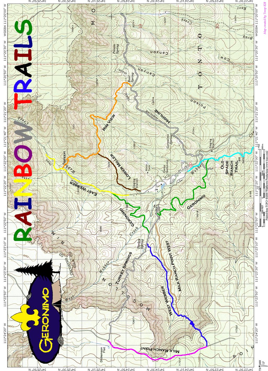
1 Camp Geronimo Rainbow Trails With over 5,000 acres of surrounding national forest, the possibilities of getting out and seeing the wilderness are almost limitless. Camp Geronimo offers some of the greatest trails in the state to hike. To recognize Scouts and leaders who take on the challenge of the Rim Country, a Rainbow Trails program has been established. A beautiful, embroidered, multicolored four-inch patch is available for purchase to be worn on a patch jacket, vest or your backpack. As you hike each trail, you may add a segment with that trail s color and name around the patch, until you have collected all of them an achievement to be proud of. Please NOTE that these trails are only available only during then summer camp season. If you have any questions concerning hiking the Camp Geronimo Trails other than during the summer camp season, contact the Grand Canyon Council Program Director at (602) at the council service center. The following information on the trails at camp provides some hints, mileage, elevation, and of course the awards that are available. So look over the trails and include some in for the troop s summer program. Trail food is available for your use. Always plan your hike with at least two adults in attendance. All out-of-camp hikes other than scheduled night hikes require a hike permit on file at Camp Headquarters. You must Sign Out/Sign In for all hikes at Headquarters or at the Health Lodge after hours. Permits are not needed for in-camp hikes. Follow all safe hiking rules set forth in the Hiking Merit Badge Pamphlet: stay on existing trails, use the buddy system, and always take plenty of water, regardless of the length of the hike. Remember, being surrounded by National Forest, Camp Geronimo offers unlimited hiking opportunities for Scout campers. In Camp Trails Totem to Totem Trail The Totem to Totem Trail which begins and ends at the totems at the front gate is an excellent Saturday or Sunday hike to orient your Scouts to camp. A map and compass are needed to stay on the trail. Have your troop and patrol yells ready and let us know who you are! This hike should take a little over two hours of your time and will cover 3 to 4 miles. Fireside Trail The in camp Fireside Trail begins along the west road south of the Webber Creek Lodge and heads upward past ceremonial grounds and along the fence line. About ⅔ of the way through the trail you will see the magnificence of the Mogollon Rim. Also visible will be the scars of the Dude Fire of 1990 and the Bray Creek Fire of This hike should take about 1½ hours of your time and will cover 1 to 2 miles. So, enjoy the views. Border Trail This trail begins off of the Fireside Trail, and will lead past Campsite 1 and end at Campsite 29. Enjoy walking the west border of Camp Geronimo.
 and continues on from Tonto Creek to Highway 260 east of Christopher Creek through heavily forested areas at an average elevation of 5,700 feet for a distance of")

2 Out of Camp Trails Highline Trail This famous trail begins at the base of Mogollon Rim just south of Pine and winds its way eastward along the rim through Washington Park on to Tonto Creek (just below the State Fish Hatchery) and continues on from Tonto Creek to Highway 260 east of Christopher Creek through heavily forested areas at an average elevation of 5,700 feet for a distance of approximately 50 miles. Between Tonto Creek and Highway 260 there is the ability to go to the Theodore Roosevelt R-C Scout Ranch (about 38 mile from Camp Geronimo). Rim View Trail White Markers Max Elevation 6033 ft Trail to Bear Springs Max Elevation 6247 ft Trail to Bray Creek The Camp Geronimo Rainbow Trails Segment can be earned by hiking to Bear Springs or Bray Springs. The hike to Bear Springs is 1.6 miles one way. The hike to Bray Creek is 2.7 miles one way; that is 1.1 mile beyond Bear Springs. From the parking lot proceed south through the totems on the road to camp about 0.15 miles to the Highline Trailhead. It will be on the on the left side of the road. Follow the white markers to Bear Springs (1.6 miles) and at that point make your choice: Choice 1: Continue on the Highline Trail to Bray Creek (an additional 1.1 miles) Return the same way. Choice 2: Take the Rim View Trail to the Lower Miller Trail (1.5 miles). At the junction of the Lower Miller Trail and either: Return to camp behind the east showers via the Lower Miller Trail (about 0.8 miles). Continue on the Rim View Trail (an additional 0.8 miles) to the East Webber Trail and return to camp on the north side. The Rim View Trail (2.3 miles) connects the Highline Trail with the East Webber Trail, making it possible to cover both in one day. About 1.5 miles from Highline Trail (or 0.8 miles from the East Webber Trail) this trail intersects the Lower Miller Trail. Orange Markers Max Elevation 6495 ft There is a steep descent from the Rim View Trail to East Webber at the end when coming from the Highline Trail (or steep ascent from the East Webber to Rim View Trail at the start when going to the Highline Trail). East Webber Trail The 2 mile East Webber Trail leaves camp on the north side and winds along Webber Creek, up a beautiful canyon. The East Webber Trail junction with the Rim View Trail is about 1 mile up the trail. Explore further up the canyon and return by backtracking; Lower Miller Trail to Rim View The Lower Miller Trail leaves camp behind the east showers along the fence line and meets the Rim View Trail about 0.8 miles up. Yellow Markers Max Elevation 7290 ft at Rim Brown Markers Max Elevation 6307 ft
. The intersection with the northern end of the Milk Ranch Point Trail (Forest Road 218) lies 0.7 miles further including a steep climb up to the rim.")
 is the walk along the top of the rim with some great picturesque views on Forest Road 218 between the trailheads of the West Webber Trail and the Turkey Springs Trail.")
3 Turkey Springs Trail The Turkey Springs Trail leaves camp along the path west of the handicraft lodge and continues past the springs on West Camp Road climbing towards Balanced Rock (1.6 miles, 6840 Elevation). The intersection with the northern end of the Milk Ranch Point Trail (Forest Road 218) lies 0.7 miles further including a steep climb up to the rim. Milk Ranch Point Trail The Milk Ranch Point Trail (1.4 Miles) is the walk along the top of the rim with some great picturesque views on Forest Road 218 between the trailheads of the West Webber Trail and the Turkey Springs Trail. Grey Markers Max Elevation 7317 ft Purple Markers Max Elevation 7241 ft West Webber Trail The West Webber Trail is a longer but more scenic (and easier) trip to the top of the rim to the southern end of the Milk Ranch Point Trail. Leave beyond Campsite 12 on West Camp Road along the path west of the craft lodge. Dark Blue Markers Max Elevation 7234 ft Follow the Turkey Springs Trail 0.6 miles to the signpost for West Webber Trail, near the spring. Proceed on the West Webber 1.9 miles to the southern end of the Milk Ranch Point Trail. Milk Ranch Point West Trail The Milk Ranch Point West Trail runs parallel to West Webber Trail and allows an alternate route or nice round trip hike for those Scouts who are not quite ready to make it up to the rim. Leave beyond Campsite 12 on West Camp Road along the path west of the craft lodge. Follow the Turkey Springs Trail 0.3 miles to the signpost for the Milk Ranch Point West Trail. Proceed up Milk Ranch Point West 1.3 miles to the intersection with West Webber. Turn right and return to camp via West Webber Trail. Old Spade Ranch Trail The Old Spade Ranch Trail leaves camp at the southwest end of the parking lot crossing the creek and heading west. Turn left, this trail runs all the way to the Control Road (3.2 miles). Return via Control Road is okay on weekdays when accompanied by an adult (4 miles back to the totems). By the way, there is No Water. Geronimo Trail The Geronimo Trail begins about 0.3 miles down the Old Spade Ranch Trail. Tan Markers Max Elevation 6330 ft Light Blue Markers Max Elevation 5651 ft Follow the trail until it intersects with Turkey Springs (1.6 miles). Green Markers Max Elevation 5762 ft Turn left and hike up Turkey Springs 0.25 miles until you see the sign for the continuation of the Geronimo Trail on the right. Follow the trail an additional 1.1 miles until it intersects the East Webber just north of the camp. Return to the north side of the camp via the East Webber Trail.

4 The Rainbow Trails Trail Miles Totem To Totem Trail 4.0 Fireside Trail 2.0 Geronimo Trail 1.6 Lower Miller Trail To Rim View 0.8 West Webber Trail 1.9 East Webber Trail 2.0 Milk Ranch Point Trail 1.4 Milk Ranch Point West Trail 1.3 Turkey Spring Trail 2.3 Highline Trail 2.9 Old Spade Ranch Road 4.0 Rim View Trail 2.3 Possible Day Hikes or Overnight Backpacking Trips Rainbow Trails Loop 1 (3.3 mile trip) Geronimo Trail to Turkey Springs Trail miles Geronimo (Turkey Springs) Trail to Continuation Junction miles Geronimo Trail Continuation to East Webber Trail miles East Weber Trail to camp miles Rainbow Trails Loop 2 (4.1 mile trip) Highline Trail to Bear Springs miles Rim View Trail Bear Springs to Lower Miller Trail miles Lower Miller Trail to Camp East Side Showers miles Rainbow Trails Loop 3 (4.9 mile trip) Turkey Springs Trail to Milk Ranch Point West Trail Junction miles Milk Ranch Point West Trail to West Webber Trail Junction miles West Webber Trail to Milk Ranch Point Trail Junction miles Milk Ranch Point Trail to Turkey Springs Trail miles Turkey Springs Trail to Camp miles Rainbow Trails Loop 4 (6.1 mile trip) Highline Trail to Bear Springs miles Rim View Trail to East Webber Trail miles East Webber Trail to camp miles Rainbow Trails Loop 5 (6.2 mile trip) Turkey Springs Trail to West Webber Trail Junction miles Turkey Springs Trail from West Webber Trail Junction to Balanced Rock miles Balanced Rock to Northern End of Milk Ranch Point Trail miles Milk Ranch Point Trail miles West Webber Trail to Turkey Springs Trail Junction miles Turkey Springs Trail to camp miles
5

6 Camp Geronimo Area TOPO Map TOPO Maps The USGS Store (downloads) TopoQuest Map Finder! A variety of search tools for you to find the topographic map you're looking for. 7.5" Quadrangle Maps - Scale 1:24000 USGS Map Name: Pine, AZ USGS Map Name: Kehl Ridge, AZ MRC: 34111D4 Map Center: N W Pine Arizona D4-TF DMA 3752 IV NW-Series V898 MRC: 34111D3 Map Center: N W Kehl Ridge, Arizona N W11115/ AMS 3654 III NW-Series V898


7 Chief Miller's Trail Special Trails (With Restricted Availability) A continuing Camp Geronimo tradition is the Chief Miller's Trail to Roosevelt Peak. The award, named for George F. "Chief" Miller, is a strenuous award to earn. This hike is part of the Spade Ranch Program, and is also open to adult leaders. The Miller s Trail Hike is scheduled on Wednesday at 8:00am departing with a staff guide from Knappenberger Lodge. Ask your program commissioner for details. This hike is not available for general troop hiking. Levi Young s Nature Trail The Levi Young s Nature Trail is available as part of Nature Lodge program, this hike includes nature quiz to qualify. Scouts can learn about the trees and plants of Camp Geronimo. The Levi Young Nature Trail can be scheduled Sunday through Thursday between 1:30pm and 4:00pm at the Nature Lodge where a self guided package is available. Please limit groups to 20 people. The trail should take between 45 minutes to 1 hour. Solo Hike This is an outstanding experience available only to Scouts nominated by their Scoutmaster after three or more years at Camp Geronimo for at least three prior summers and who stand out among all campers. Selected Scouts will hike solo to a secret place and spend a night alone before returning to camp. Scoutmasters may make recommendations to the Camp Director concerning boys who may qualify. Recommendations must be turned in on Sunday by 5:00pm to Headquarters so that interviews and selections can be made as early as possible. Each Scout must convince the camp director that he is prepared to challenge the secret route and spend the night alone in the wilderness. To be selected is an honor, to succeed is a thrill! Solo Hike applications are available at Camp Headquarters. Only seasoned Scouts need apply.

8 Try one of these courses with your GPS. Geronimo Trail to Eagle Campsite Cache Commissioners Cache Creekside Cache Pillars of Scouting The Code See the Shack Staff to get a coordinates sheet. We have several GPS units available for you to check out. If you have a problem with a cache, please come back and see the Shack Staff for guidance. Once you complete the geocache, a segment is available for purchase at the trading post. Geronimo Geocaches Night Eye Trails These evening compass courses are introductory hikes, designed to provide experience and adventure on the trail for boys who are new to Scouting and Camp Geronimo. A compass, a good flashlight and determination make these night hikes fun for young and old alike. Your Scouts will enjoy thinking that any one of the fluorescent eyes might be the real thing (AND IT MIGHT!). Start with the Cat Eye for the new Scouts and let them work their way up through these hikes of varying difficulty to give your Scouts a challenge. Watch for eyes of various colors. Many will be red, but others may be white, green, or yellow. A Few Hints for the Eyes! Take along flashlights with GOOD batteries. Arrange your Scouts in patrols of no more than 6 people. Each patrol looks for and spots one set of eyes glowing in the distance. Each Scout leads the patrol there, and retires to the rear. This way, all the boys get several turns. Upon reaching a pair of eyes: STOP... take your next compass reading, continue along what appears to be the beaten path the eyes are moved frequently to keep the trails fresh and interesting. If the trail seems to disappear, a few Scouts may be sent out to find where it picks up again. Remember, leave several fellows at the last pair of eyes you spotted. Verify previous bearing before continuing. The end of each trail is a definite location and requires a written answer. Your Commissioner will verify your success.


9 Camp Geronimo Rainbow Trails Night Eye Trails Signup Sheet Troop #: # of Scouts: Session #: Campsite: At Camp Scoutmaster s Name: Address: City: ST: ZIP: Place the name of the trail(s) you wish to complete and the desired time. PM Saturday Monday Tuesday Thursday 7:30 7:50 8:10 8:30 8:50 9:10 9:30 9:50

10 Grand Canyon Council Camps

11 Directions to Camp Geronimo Leaving the Phoenix Metropolitan Area, take State Highway 87 north. After reaching Payson, continue on Highway 87 about 12 miles until you reach the Control Road turn-off marked by highway marker 265, turn right. Continue on the Control Road (dirt) for about six miles, then turn left onto Webber Creek Road (FR) and drive approximately 1½ miles into camp. Allow 2 to 2½ hours driving time. Leaving from Flagstaff, take Lake Mary Road to State Route 87 south past Pine to Control Road. Turn left on Control Road (dirt) for about six miles, then turn left onto the Webber Creek Road and drive approximately 1½ miles into camp. Allow 2 to 2½ hours driving time. Leaving Winslow, take State Route 87 south past Pine to the Control Road turning left and proceed as stated above.
12 Camp Geronimo Map
CAMP GERONIMO 2019 LEADERS GUIDE. camping. campgeronimo.org. Grand Canyon Council
 CAMP GERONIMO 2019 LEADERS GUIDE camping. campgeronimo.org Grand Canyon Council TABLE OF CONTENTS Welcome... 2 Camp Arrival... 3 Check-In... 4 Vehicles & Campsite... 5 Weekly Schedule... 6 Leaders, Flag
White Mountain Wilderness Trails
 The area in which these hikes are located is rugged high mountain country along the Mogollon Rim. This famous eastwest escarpment separates Arizona's high plateau from the basin and range below. These
Bradshaw Trails Series
 Bradshaw Trails Series Curtis James Troop 7014 Curtis.James@erau.edu My Motto: Never get lost! Hiking Rules Bradshaw Hiking Patch Series Hiking Tools Hiking Rules Hiking Merit Badge* Take five 10-mile
Hike at Pico Blanco Labor Day Weekend!
 Hike at Pico Blanco Labor Day Weekend! The Pico Blanco Hymn Here among the trees majestic Pleasures you will find On the trails of Pico Blanco With your friends and mine Trail the Eagle ever onward This
Lava Mountain Trail Distance: Elevation Range: Trail Type: Difficulty: Season: Driving Distance: Driving Time: USGS Maps: Pros Cons
 Lava Mountain Trail Distance: 13.4 miles (including the side trip to North Star Lake) Elevation Range: 5900'-8330' Trail Type: singletrack Difficulty: moderate Season: late June-October Driving Distance:
Mazatal Wilderness Trails
 Mazatal Wilderness Trails "Mazatzal" to the Paiute means, "empty space between". The Mazatzal Wilderness Area is located in central Arizona between the Verde River on the west and the Beeline Highway (Arizona
Mazatzal Wilderness Trail Maintenance and Exploration
 Mazatzal Wilderness Trail Maintenance and Exploration March 15-19 (Wednesday - Sunday) Difficulty: Beginner Camping: Car Camping Mileage: Wednesday ~4 miles Thursday ~4-6 miles Friday ~4-6 miles Saturday
HENRY ROWE SCHOOLCRAFT TRAIL
 HENRY ROWE SCHOOLCRAFT TRAIL This map and compass trail may be divided into north and south loops. The South Loop is about 9 miles in length while the North Loop is about 5 miles. Many hiking options are
Your First and Last Day!
 Your First and Last Day! - 1 - Sunday Schedule of Events Check-in 1:00-3:00 pm Camp Leader Check-in-Camp Office Med. Check- Health Office Shooting Sports Orientation- Rifle Range Dining Hall Orientation-
Route #1) Mt. of the Holy Cross - North Ridge
 Mt. of the Holy Cross - North Ridge") Climbing 14ers can be very dangerous, please read the Mountaineering Safety Page and make sure you have a map+compass and can use them effectively, without the help of electronic devices. Route #1) Mt.
Climbing 14ers can be very dangerous, please read the Mountaineering Safety Page and make sure you have a map+compass and can use them effectively, without the help of electronic devices. Route #1) Mt.
Pendola Scout Reservation s
 www.yosemitescouting.org Pendola Scout Reservation s CAMP JOHN MENSINGER 2018 Senior Patrol Leaders Packet Recommended Unit Equipment Check List American Flag Unit flag Patrol flags Sharpening stones and
Merit Badge Information
 Merit Badge Information The Basics: CJM offers more than 55 Merit badges, taught in half-day, one-day or two-day vertical format. This schedule will allow Scouts to earn a variety of merit badges during
2015 STSR Winter Camp Leader s Guide
 2015 STSR Winter Camp Leader s Guide - 1 - Dear Leaders, Thank you for considering STSR Winter Camp as part of your scouting program. We have strived to assemble a quality program of merit badge offerings.
the merit badge program
 the merit badge program The Merit Badge program at Camp Workcoeman is extensive and includes approximately 45 badges spread over three morning sessions and an afternoon period. Troops are requested to
Camp William Hinds, BSA Leader s Guide Page-1. Merit Badge Area/Location Available to Archery MB
 These badges have requirements that need to be complete before you come to camp. If you don t do them, you will get a partial. These merit badges have prerequisites that must be met before you can signup
Rocky Mountain National Park Hiking Map By Trails Illustrated Maps
 Rocky Mountain National Park Hiking Map By Trails Illustrated Maps 10 Great Hikes for Families with Kids in Estes Park, Colorado - Choose from plenty of great family hikes in Rocky Mountain National park.
BOSTON MINUTEMAN COUNCIL 2014 PHILMONT YOUTH APPLICATION DEADLINE: January 4, 2014
 BOSTON MINUTEMAN COUNCIL 2014 PHILMONT YOUTH APPLICATION DEADLINE: January 4, 2014 (Applicants must be under 21 thru the last day of the expedition) Youth Registration will be on a first-come first-serve
Hiking Las Vegas.com
 Hike: Mt. Wilson via First Creek Canyon route Trailhead: First Creek marked Distance: 10 miles up and back Elevation gain: 3,400 feet Elevation of Peak: 7,070 feet Time: 7 to 9 hours (up and back) Difficulty:
2014 WEBELOS CAMP CAMPSITE REQUEST FORM Reserve your Pack s campsite for the 2014 summer session. All sessions are limited to 250 boys.
 2014 WEBELOS CAMP CAMPSITE REQUEST FORM Reserve your Pack s campsite for the 2014 summer session. All sessions are limited to 250 boys. PACK DISTRICT COUNCIL DATE CHOOSE YOUR CAMPSITE Circle the session
Program Guide 2019 Spring Break Camp
 Program Guide 2019 Spring Break Camp Heart of Virginia Council Scout Reservation Boy Scouts of America 1723 Maidens Rd. Maidens, Virginia 23102 Phone: 804-204-2625 www.bradysaunders.net The Heart of Virginia
MERIT BADGES OFFERED 2012
 MERIT BADGES OFFERED 2012 ANIMAL SCIENCE TIMES OFFERED: 4 pm Paper and pencil ARCHERY TIMES OFFERED: 9, 11 am, 3, 4 pm LOCATION: Archery Range RECOMMENDED FOR: 3 rd year campers or older All requirements
HHCSR Boy Scout Summer Camp Camp Information Meeting
 HHCSR Boy Scout Summer Camp 2018 Camp Information Meeting 1 Boy Scout Summer Camp HHCSR 2018 2018 Brochure is in the mail! 2 Boy Scout Summer Camp HHCSR 2018 Summer Camp Schedule: Staff Arrives: June 9
Pendola Scout Reservation s CAMP JOHN MENSINGER 2017 Leader Guide
 www.yosemitescouting.org Pendola Scout Reservation s CAMP JOHN MENSINGER 2017 Leader Guide Directions to Camp John Mensinger 3 Camp Contact Information All camping and registration questions should be
CIEC 9 PEAKS AWARD SUPPLEMENT POSSIBLE ROUTES FOR THE 9 PEAKS AWARD TRIP
 CIEC 9 PEAKS AWARD SUPPLEMENT POSSIBLE ROUTES FOR THE 9 PEAKS AWARD TRIP As you plan your trip, be aware of 3 regulations in this wilderness: 1. Camp only in designated campsites. 2. No campfires allowed.
Hiking Las Vegas.com
 Hike: Juniper Peak up and back Trailhead: Oak Creek Canyon marked Distance: 5.5 miles round trip Elevation gain: 2,200 feet Elevation peak: 6,109 feet Time: 4 to 5 hours - Up and back Difficulty: 3 Danger
Geocaching at the Klondike 2014
 Geocaching at the Klondike 2014 What is a Geocache? What do they typically look like? What is Geocaching? What is a GPS? How does a GPS work? What does Geocaching have to do with scouting? How many geocaches
Driving Time: 3 hours (allow extra time for stops)
") Scenic Byways loop This journey takes visitors through the eastern edge of Mt. Rainier National Park and along two of Washington s most beloved scenic byways, the Chinook Byway and the White Pass Scenic
Scenic Byways loop This journey takes visitors through the eastern edge of Mt. Rainier National Park and along two of Washington s most beloved scenic byways, the Chinook Byway and the White Pass Scenic
Withlacoochee District. Presents. Withlacoochee Scouts on the Seven Seas Camp-O-Ree November 14-16,2014
 Withlacoochee District Presents Withlacoochee Scouts on the Seven Seas Camp-O-Ree November 14-16,2014 1 TABLE OF CONTENTS CAMP-O-REE REGISTRATION FORM 3 CAMP-O-REE OVERVIEW 4 MERIT BADGE PRE-REQUISITES
West Trails Trek Guide. Chief Pontiac Trail Credential Hikes
 West Trails Trek Guide Kensington Start Edition Chief Pontiac Trail Credential Hikes RDS.WTW.110609 WP# Dist. Accum. Dist. Accum. Feet Miles Meters Meters 1 0 0.0 0 0 2 410 0.1 125 125 3 164 0.1 150 275
Summer Camp 2014 Overview
 GENERAL INFORMATION ABOUT CAMP Drop off your scout by 1:00pm Sunday June 15 th at Camp in full Class-A uniform with all his gear. As you enter Woodruff, continue on the main road and the drop off site
Camp Tahquitz Summer 2017 CAMP FORMS
 CAMP FORMS CF-1 Preparing for camp means preparing for a great and exciting summer. It also means being sure that you have all of the proper forms completed by the time you reach camp. This section should
KMSR MERIT BADGE OPPORTUNITIES Archery
 Blue card merit badge applications are used at camp. They must be signed by the unit leader and turned in to the merit badge counselor. It is imperative that they be turned in at the first merit badge
MERIT BADGES OFFERED 2011
 MERIT BADGES OFFERED 2011 ARCHERY TIMES OFFERED: 9, 11 am, 3, 4 pm LOCATION: Archery Range RECOMMENDED FOR: 3rd year campers and older All requirements may be finished at camp. Requirement 4 requires shooting
wilderness survival scouting outcomes advancement opportunities 105
 Wilderness Survival Early man practiced wilderness survival because he had to. We practice it today because it is a challenge and because even today we might confront a situation requiring knowledge of
2016 Washington, D.C. Spring Camporee
 2016 Washington, D.C. Spring Camporee Official Event Information Packet Washington, D.C. District, BSA 2016 Washington, D.C. Spring Camporee Theme: First Aid and Emergency Preparedness: Throughout the
Trail Beginning Elevation: 7553 ft The Poison Creek Trailhead is located at the end of National Forest Road 646E (NF-646E).
.") West Mountain Trails Poison Creek Trail #134 Length: 2.9 miles (4.7 km) Difficulty Horseback: A good trail for the first time west mountain rider, some steep sections Hiking: Most Difficult USGS Maps:
West Mountain Trails Poison Creek Trail #134 Length: 2.9 miles (4.7 km) Difficulty Horseback: A good trail for the first time west mountain rider, some steep sections Hiking: Most Difficult USGS Maps:
2016 Winter Camp Merit Badge Addendum
 2016 Winter Camp Merit Badge Addendum Clements Scout Ranch Trevor Rees-Jones Scout Camp 2016 Winter Camp Merit Badge Addendum The Merit Badge program is an important feature of our Winter Camp program.
CAMP MARRIOTT GOSHEN SCOUT RESERVATION Daily & Program Schedules Weeks 1 - LDS Week
 CAMP MARRIOTT GOSHEN SCOUT RESERVATION 2018 Daily & Program Schedules Weeks 1 - LDS Week TABLE OF CONTENTS Daily Schedules...3 Monday...3 Tuesday...4 Wednesday...5 Thursday...6 Friday...7 Saturday...8
Isle Royale Info Trip Packages. The Greenstone Ridge Trail
 s East Section West Section Total Miles 42.7 Difficulty East to West 6.884 Difficulty West to East 6.965 [This is based on 7 Day Shorter Miles sample itinerary. However, difficulty is close to the same
 Hike date Exertion Destination/ Leader(s) Description and Contact info Rating Hike Name 7/8-12/10 S+ Extreme Pleinair Sandy Compton Contact info: 208-290-1281 or sandy@scotchmanpeak.org This hike is nearly
Other Agencies and Organizations
 Daniel Boone National Forest 1700 Bypass Road WInchester, KY 40391 859-745-3100 Location Northern terminus is near Morehead, Kentucky. Southern terminus is located in the Big South Fork NRRA in Tennessee.
2018 POLAR BEAR. December 4, To: All Bucktail Council Scoutmasters From: 49 th Annual Polar Bear Committee
 2018 POLAR BEAR December 4, 2017 To: All Bucktail Council Scoutmasters From: 49 th Annual Polar Bear Committee Planning is nearly finished for the 2018 Polar Bear Event. The event will be held at Camp
Team Outdoor Rigorous Challenge (TORC)
") New River District Fall Camporee: Team Outdoor Rigorous Challenge (TORC) September 15-17, 2017 Camp Ottari >>> Camp Powhatan Welcome to the 2017 New River District Fall Camporee also known as the second
New River District Fall Camporee: Team Outdoor Rigorous Challenge (TORC) September 15-17, 2017 Camp Ottari >>> Camp Powhatan Welcome to the 2017 New River District Fall Camporee also known as the second
National Outdoor CAMPING Badge Tracking
 National Outdoor CAMPING Badge Tracking Use this sheet to track your progress toward the National Outdoor Camping Badge. I already have the Camping Badge and am applying for a Gold Device because I have
HHCSR Boy Scout Summer Camp Camp Information Meeting
 HHCSR Boy Scout Summer Camp 2015 Camp Information Meeting 1 2015 Brochure has mailed 2 Theme Dirty Jobs Summer Camp Information Meetings to be scheduled: February Roundtable Breakout Alternate meeting
Orienteering. The fundamental outdoors skill!
 The fundamental outdoors skill! Orienteering Nothing will make you feel more confident in the out of doors like knowing how to find your way in the woods. Orienteering Prepared by: Jeffrey Lybarger Assistant
26 th Duty to God and Country Retreat
 26 th Duty to God and Country Retreat Location: Franklin D Roosevelt State Park 2970 Georgia Highway 190 Pine Mountain, GA 31822 Small Group Camp G.P.S. Coordinates N 32.837533 /W-084.815616 When: September
Increased self-confidence A desire to protect the wildlife of our country
 Wildlife Management A major concern in this country is vanishing wildlife and wildlife habitat. Some of this loss comes from a lack of knowledge about the creatures of nature. This program feature will
Troop 349. Pioneering Campout. Lake Anna VA State Park. Spotsylvania, VA
 Troop 349 Pioneering Campout at Lake Anna VA State Park Spotsylvania, VA 14-16 March 2014 Deadline for permission slip & payment Tues, 11 March 2014 Scouting - Fun with a purpose1 Lake Anna State Park
The temperature is nice at this time of year, but water is already starting to be scarce.
 In March of 2003, Scott Morrison and I went backpacking in the Grand Canyon. The temperature is nice at this time of year, but water is already starting to be scarce. Another issue with this time of year
Tukabatchee Area Council
 The registration form has been corrected to include Citizenship in the Nation and Citizenship in the World on the form and the addition of American Heritage merit badge to the registration form and to
WILL YOU SURVIVE??? LEADER S GUIDE BOOK
 WILDERNESS SURVIVAL BOY SCOUT CAMPOREE APRIL 27-29, 2018 WILL YOU SURVIVE??? LEADER S GUIDE BOOK EMERGENCY NUMBERS Camp Director - Fred Hassman (812)202-0838 Program Director - Adam White (812)618-8234
Black Rock District Fall Camporee. Sept. 26, 27, 28, 2014 Owl Creek Reservoir Tamaqua, Pa. Leaders Packet
 Black Rock District Fall Camporee Sept. 26, 27, 28, 2014 Owl Creek Reservoir Tamaqua, Pa. Leaders Packet This is a rain or shine event A Scout is-- Prepared! 1 Back Rock District Fall Camporee Sept. 26,
Goose Pond Scout Reservation 2015 PRE-CAMP WORKSHEETS Please mail, fax or all forms to camp at least 1 week prior to your arrival.
 Goose Pond Scout Reservation 0 PRE-CAMP WORKSHEETS Please mail, fax or email all forms to camp at least week prior to your arrival. All forms are available electronically at www.nepabsa.org If your pre-registrations
HEADQUARTERS WEST LTD. CATTLE RANCHES HORSE PROPERTIES RURAL REAL ESTATE
 Aravaipa Creek Flowing Through the Property Offered for sale exclusively by: Sandy Ruppel Headquarters West, Ltd. PO BOX 542 Sonoita, AZ 85637 Phone (520) 444-1745 sandy@headquarterswest.com www.headquarterswest.com
Camp Powhatan. Getting Started
 1 What to Expect on Sunday Arrival Getting Started Troops should plan on arriving at Camp Powhatan between 1:00 and 3:00 p.m. on Sunday. A staff member will greet you in the parking lot and direct your
CAMP MALUHIA. Boy Scout Summer Camp. Program Appendix Maui County Council Boy Scouts of America. 200 Liholiho Street. Wailuku, Maui, HI 96793
 CAMP MALUHIA Boy Scout Summer Camp Appendix 2016 Maui County Council Boy Scouts of America 200 Liholiho Street Wailuku, Maui, HI 96793 (808) 244-3724 www.mauibsa.org Camp Director: TJ Cordero (tj.cordero@scouting.org)
Camp Roosevelt February 22-24, 2019 The High Adventure Chill Out is a chance to join in one of the oldest traditions in Boy Scout history.
 Camp Roosevelt February 22-24, 2019 The High Adventure Chill Out is a chance to join in one of the oldest traditions in Boy Scout history. It's a wonderful opportunity for units to come together as a Council
OWASIPPE SCOUT RESERVATION
 TROOP 894 PARENT & SCOUT HANDBOOK OWASIPPE SCOUT RESERVATION CHICAGO AREA COUNCIL BOY SCOUTS OF AMERICA 2010 Season / Our 14 th and Owasippe s 100 th THE LEGEND CONTINUES ESTABLISHED 1911 All Scouts like
50 TH ANNIVERSARY POLAR BEAR
 November 16, 2018 50 TH ANNIVERSARY POLAR BEAR To: All Bucktail Council Scoutmasters From: 50 th Annual Polar Bear Committee Planning is nearly finished for 50 th Annual Polar Bear Event. The event will
Route #2) Mt. Massive - Southwest Slopes
 Mt. Massive - Southwest Slopes") Route #2) Mt. Massive - Southwest Slopes Difficulty: Class 2 Ski: Advanced, D6 / R2 / III Exposure: Summit Elevation: Trailhead Elevation: Elevation Gain: Round-trip Length: Trailhead: County Sheriff:
Route #2) Mt. Massive - Southwest Slopes Difficulty: Class 2 Ski: Advanced, D6 / R2 / III Exposure: Summit Elevation: Trailhead Elevation: Elevation Gain: Round-trip Length: Trailhead: County Sheriff:
Friday October 3. Lower Javelina Trail - Level D. about 3 miles, less than 500. Hike Contact: Joel Tormoen
 Friday October 3 Lower Javelina Trail - Level D. about 3 miles, less than 500 Hike Contact: Joel Tormoen joeltormoen@gmail.com Depart WB trailhead 8:00 am - return before 11:00 am This quite easy hike
Camelback High Adventure Backpacking Award
 Trek Aid 103 Camelback High Adventure Backpacking Award High Adventure Team San Diego - Imperial Council Boy Scouts of America Page Intentionally Left Blank Trek Aid 103 Camelback High Adventure Backpacking
CAMPOUT PLANNING GUIDE
 BOY SCOUTS OF AMERICA TROOP 227 CAMPOUT PLANNING GUIDE 08/24/2010 Page 2 BSA TROOP 227 CAMPOUT PLANNING GUIDE Intro. - Monthly campouts are an integral part of the Troop 227 Boy Scouting program. Traditionally,
Royal Gorge Far Out Trail to Le Point
 Royal Gorge Far Out Trail to Le Point Direction to trailhead: From East Ridge Campground: Drive west from Canon City on US 50 to County Road 3A, the entrance road to the Royal Gorge Park. Turn left onto
COURSE & TRAINING ADDENDUM
 COURSE & TRAINING ADDENDUM WINTER CAMP 2017 - MERIT BADGE ADDENDUM TABLE OF CONTENTS INTRODUCTION... 1 HELPFUL HINTS... 1 CAMPMASTER COURSE REGISTRATION... 1 COURSE SCHEDULES... 2 COURSE MATERIALS... 2
Griffith Park Trail Run Trail Guide Click for
 The Griffith Park Trail Run by Hike- LosAngeles.com Griffith Park Trail Run Trail Guide Click for downloadable cell phone guide and map from EveryTrail. DISTANCE: 4.55 Miles ELEVATION: 1280' ELEVATION
Troop 1083 Summer Camp. Goshen Scout Reservation Camp Olmsted. July 17 to July 23, 2011 (Sunday to Saturday)
") Troop 1083 Summer Camp Goshen Scout Reservation Camp Olmsted July 17 to July 23, 2011 (Sunday to Saturday) Medical Requirements Forms due to Scoutmaster by June 20 All Scouts and leaders: New BSA Form
Troop 1083 Summer Camp Goshen Scout Reservation Camp Olmsted July 17 to July 23, 2011 (Sunday to Saturday) Medical Requirements Forms due to Scoutmaster by June 20 All Scouts and leaders: New BSA Form
Camp Long Lake Troop 16. Scoutmaster: Keith Henderson
 Camp Long Lake 2016 Troop 16 Scoutmaster: Keith Henderson Introduction: Meet Keith Henderson, Troop 16 Camp Long Lake Scoutmaster. Parent Attendance at Camp: There are a limited number of adult spots available.
The Ultimate Retreat- A Blissful Journey GRAND CANYON, USA. September 20-29, 2017 with Yoga Master Ulrica Norberg
 The Ultimate Retreat- A Blissful Journey GRAND CANYON, USA September 20-29, 2017 with Yoga Master Ulrica Norberg This is a once in a liftetime retreat. What you embark on is a soulful journey into the
Trip Report: Backpack to East Boulder Lake in California Trinity Alps, July 7-9, 2016
 Trip Report: Backpack to East Boulder Lake in California Trinity Alps, July 7-9, 2016 Trekkers: Richard Hales, Aleece Townsend, Carol Mockridge, Rosalie Rybka, Elisabeth Zinser Day 1: Richard and Aleece
Marilla Reservoir to Chestnut Ridge via Marilla Trails and Bullis Hollow Trail east to west
 USGS topographic maps useful to this hike are the Bradford and Stickney 7.5 minute sectionals. These notes are designed to assist in identifying distance and location using geophysical and man-made characteristics
After the Coosa show, join us for an ice cream social, patch trading, and OA Lodge display!
 Every spring, in the woods high atop Lookout Mountain, Order of the Arrow members (Scouting s National Honor Society) gather at Comer Scout Reservation in Mentone to celebrate the Order s history and honor
Trail Details Location
 Blind Blue Ribbon Centennial Conditions: Forest trail, with duckboards, and rope railing. Need: Blind trail activity bag, available in the camp office. None Availability: Open all seasons. Use the outdoor
Troop 323 s Week at Camp Geronimo, June 15 th to 22 nd, 2013 (Sat to Sat)
") Troop 323 s Week at Camp Geronimo, June 15 th to 22 nd, 2013 (Sat to Sat) (Items listed in italics are additional information that should have accompanied this letter.) 1. Departure Time: Please show up
Troop 323 s Week at Camp Geronimo, June 15 th to 22 nd, 2013 (Sat to Sat) (Items listed in italics are additional information that should have accompanied this letter.) 1. Departure Time: Please show up
Base Camp Program. Advancement
 Advancement Summer camp has traditionally been viewed as a convenient place where Scouts can earn lots of merit badges in a short amount of time. However, the Blue Ridge Mountains Scout Reservation offers
TROOP FIVE BOY SCOUTS OF AMERICA (
 TROOP FIVE BOY SCOUTS OF AMERICA (http://www.troop5.net) HISTORIC MOUNT WASHINGTON HIKE LOCATION: White Mountain National Forest, New Hampshire DATE: Friday - Monday, June 25-28 th, 2010. TIME: Be at the
2016 Council Camporee. Leaders Guide
 2016 Council Camporee Leaders Guide Dear Leaders: Rio Grande Council Boy Scouts of America The annual Rio Grande Council Camporee will be held April 22-24 at Camp Perry. Congratulations to last year s
CAMP JOHN MENSINGER 2017 Leader Guide
 www.yosemitescouting.org Pendola Scout Reservation s CAMP JOHN MENSINGER 2017 Leader Guide Dear Unit Leaders, Thank you for choosing Camp John Mensinger as your 2017 Boy Scout Resident Camp. We look forward
Camp DuPortail. Passport. Adventure. Hawk Mountain Scout Reservation. Camp Leader Program Guide 2019
 Camp DuPortail Passport to Hawk Mountain Scout Reservation Camp Leader Program Guide 2019 Directions to Hawk Mountain Scout Reservation Location: The Hawk Mountain Scout Reservation is located in Schuylkill
Hawk Mountain Scout Reservation Camp Guide For Scout Leaders 2018
 Hawk Mountain Scout Reservation Camp Guide For Scout Leaders 2018 This leader guide is for both Cub Scouts and Boy Scouts to use. The process to plan, prepare, and attend camp is the same in both programs.
A Guide to Unit Trek Planning. trek safely
 A Guide to Unit Trek Planning trek safely Backcountry accidents are more likely to occur if trek planning is inadequate. For example, a unit may overestimate its ability to complete a long or difficult
WEBELOS WOODS Oct. 2-4, 2009 Double V Scout Ranch
 WEBELOS WOODS Oct. 2-4, 2009 Double V Scout Ranch Information Packet Welcome To Webelos Woods! On behalf of the staff and committee of Webelos Woods I would like to invite you and your units to this year
1 Permanent Full Time Forester GS /07/09 Kaibab National Forest Duty Station: Williams or Tusayan, AZ
 1 Permanent Full Time Forester GS-460-05/07/09 Kaibab National Forest Duty Station: Williams or Tusayan, AZ Merit Vacancy Announcement: Open Monday January 11 th to Friday January 20 th 2016 and working
2004 Fall CAMPOREE "Wilderness Survival" FRONTIER TRAILS DISTRICT
 SUBJECT: TO: FROM: 2004 Fall CAMPOREE "Wilderness Survival" FRONTIER TRAILS DISTRICT SCOUTMASTERS VENTURE ADVISORS SECOND YEAR WEBELOS DEN LEADERS DISTRICT COMMITTEE MEMBERS DISTRICT/UNIT COMMISSIONERS
ALLEGHENY HIGHLANDS COUNCIL COUNCIL INVITATION TO ADVENTURE SKILLOREE 2009 May CAMP MERZ Mayville N.Y.
 ALLEGHENY HIGHLANDS COUNCIL COUNCIL INVITATION TO ADVENTURE SKILLOREE 2009 May 15-17 CAMP MERZ Mayville N.Y. We are starting off the New Year right with some terrific events this year. So to challenge
2019 PROCEDURES & PROGRAM SECTION. SUPPORT & HELP (419)
") 2019 PROCEDURES & PROGRAM SECTION SUPPORT & HELP (419) 422-4356 Campberry.scouts@gmail.com www.blackswampbsa.org/camping/scouts-bsa-camping TABLE OF CONTENTS Contents What s New at Camp Berry... 6 New
2019 PROCEDURES & PROGRAM SECTION SUPPORT & HELP (419) 422-4356 Campberry.scouts@gmail.com www.blackswampbsa.org/camping/scouts-bsa-camping TABLE OF CONTENTS Contents What s New at Camp Berry... 6 New
MOAB peopleforbikes.org/e-bikes
 emtb ADVENTURE MAPS MOAB peopleforbikes.org/e-bikes OVERVIEW Moab, Utah is a world-class mountain bike destination known for its vast, red sandstone landscapes nestled below the rising peaks of the La
Fire Use And Safety Rules From The Boy Scout
 Fire Use And Safety Rules From The Boy Scout Handbook The Boy Scouts of America is pleased to provide this booklet it might be the contains exercises, based on a set of personal safety rules, that will
Note: Coordinates are provided as Universal Transverse Mercator UTM Zone U21, North American Datum 1983 (NAD 83).
.") Northern Traverse Route Description The Northern Traverse (formerly the North Rim Traverse) is an unmarked and rugged backcountry hiking route. It is known be a demanding hike, because of its terrain and
Northern Traverse Route Description The Northern Traverse (formerly the North Rim Traverse) is an unmarked and rugged backcountry hiking route. It is known be a demanding hike, because of its terrain and
throu Booth Hill Green Belt
 s k r a p s l l u b m u r T Explore gh Geocaching throu Booth Hill Green Belt This was originally a concept to try and preserve some of the land in our town, without hurting the developers that are creating
Selecting Your Philmont Trek January Advisor Briefing by Bill Garmoe January 21, 2018
 Selecting Your Philmont Trek January Advisor Briefing by Bill Garmoe January 21, 2018 Selecting a Great Trek Part 1 The November presentation was designed to educate you about Philmont and the available
SEGMENT ASSESSMENT REPORT
 2017 SEGMENT ASSESSMENT REPORT SEGMENT 3: MT ROSE / TAHOE MEADOWS TO SPOONER SUMMIT REPORT SUMMARY This report is a compilation of information collected on the Tahoe Rim Trail during assessments performed
GIFFORD PINCHOT NATIONAL FOREST
 GIFFORD PINCHOT NATIONAL FOREST 9341 Wright Meadow 93 Spencer Meadow Spencer Butte 4247' 30 30A 19 24 80 31C Lewis River Lower Falls 5 Quartz Creek 90 Taidnapam Falls Upper Falls 31 Spencer Peak 3861'
4-8 June 2018 VOLUNTEERS NEEDED!
 4-8 June 2018 Daily: 8:00 am - 4:30 pm This is an OUTDOOR Day Camp rain or shine event. VOLUNTEERS NEEDED! This camp is an ALL-VOLUNTEER program and we need you in order to make it happen. *Discounts and
Thunder Wolf District Webelos Woods 2018 "Meme-O-Palooza" UNIT LEADERS PACKET
 Thunder Wolf District Webelos Woods 2018 "Meme-O-Palooza" UNIT LEADERS PACKET Webelos Woods is a special weekend designed for Webelos Scouts and their parents to experience what awaits them in a Boy Scout
Great Plains Rendezvous. April 21-23, Williams Scout Reservation Cleo Springs, OK
 CIMARRON COUNCIL BOY SCOUTS OF AMERICA Great Plains Rendezvous April 21-23, 2017 Williams Scout Reservation Cleo Springs, OK Rendezvous Organizing Committee Rendezvous Chairman: Austin Avants (316) 214-6629
Merit Badges Offered. ARCHEOLOGY Location: Viersen Nature Center Cost: None Preparation: None
 Merit Badges Offered ARCHEOLOGY ARCHERY Location: Shooting Sports Complex Preparation: Recommended scouts be at least a 3rd year camper or 14 years of age. Requires 2 time blocks to complete. Location:
PG-1 Summer adventure at Camp Tahquitz Dear Troop Parent:
 PG-1 Summer adventure at Camp Tahquitz Dear Troop Parent: This year our troop will be attending summer camp at Camp Tahquitz, a fantastic scout camp that is located in the San Bernardino Mountains. This
Great Southern Plains Rendezvous & Cub Scout Belt Loop Bonanza. April 17-19, Williams Scout Reservation Cleo Springs, OK
 CIMARRON COUNCIL BOY SCOUTS OF AMERICA 2015 Great Southern Plains Rendezvous & Cub Scout Belt Loop Bonanza April 17-19, 2015 Williams Scout Reservation Cleo Springs, OK Rendezvous Organizing Committee