Wentworth Pass. 893m. 535m. 4 hrs. Hard track 5.1 km Circuit. 692m
|
|
|
- Emerald Charles
- 5 years ago
- Views:
Transcription

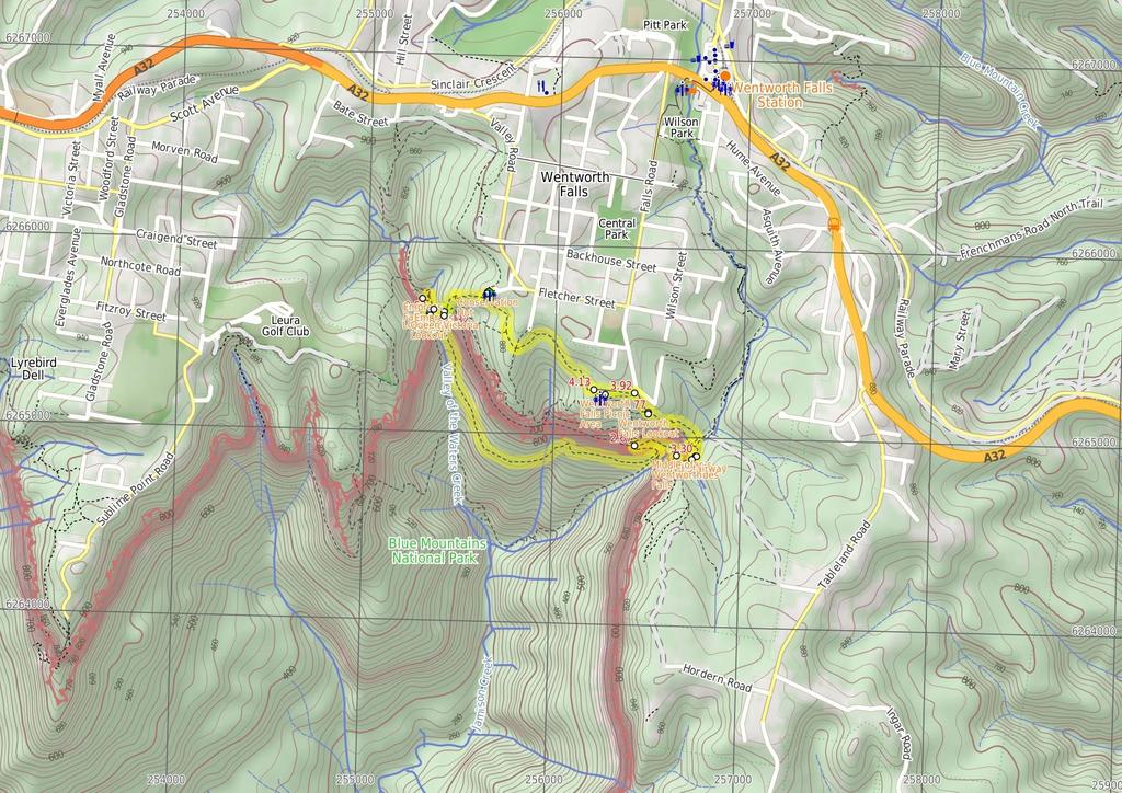
1 Wentworth Pass 4 hrs Hard track 5.1 km Circuit 4 692m This walk offers a great way to explore the magical, upper section of the Valley of the Waters. The walk starts and finishes at Conservation Hut, which has a great, picturesque cafe offering a meal or hot drink. The walk passes Empress Falls before diving deeper into the valley, then climbing out again at Wentworth Falls and returning along the plateau. 893m 535m Blue Mountains National Park Maps, text & images are copyright wildwalks.com Thanks to OSM, NASA and others for data used to generate some map layers.

2 Conservation Hut Before You walk Conservation Hut is a small cafe perched above the Valley of the Waters, Blue Mountains National Park. The hut was opened in 1963 as a meeting place for the local conservation movement. Rebuilt, Conservation Hut opened as a cafe in 1993, serving breakfast, lunch and dinner, seven days a week. Around the Conservation Hut is a small parking area, public toilets, picnic shelters, town water and B&B's. For further information or bookings call (02) More info. Bushwalking is fun and a wonderful way to enjoy our natural places. Sometimes things go bad, with a bit of planning you can increase your chance of having an ejoyable and safer walk. Before setting off on your walk check Queen Victoria Lookout The Queen Victoria Lookout is perched above the Valley of the Waters, south-west of Conservation Hut. The fenced lookout has views into the narrow section of the valley. The views are made more dramatic by the roar of the waterfalls below and the mists which frequent the area. Empress Falls are only just visible - the main views extend down Jamison Valley. Kings Tableland (left) and Sublime Point(right) dominate the views and the eastern edge of Mount Solitary and beyond is also visible. Empress Lookout Empress Lookout is a fenced and signposted lookout, perched on a sandstone overhang above the Valley of the Waters Creek. There is a view down to part of the Empress Falls and into the canyon. The views are filtered through the surrounding trees. It makes for a good spot to catch your breath when walking into, or out of, the Valley of the Waters. Empress Falls Empress Falls is a spectacular waterfall in the Valley of the Waters. The Valley of the Water Creek comes out of the slot in the cliff and tumbles down a series of cliffs to a sandy pool. The fall is the site of the last abseil in a popular canyon, making a great site for walkers in the area. Stepping stones help walkers cross below the falls. There is a small overhang next to the falls, giving the area shade and offering a great place to rest. Lodore Falls Lodore Falls are a lovely set of falls on the Valley of the Waters Creek. The narrow falls have a staircase on one side and stepping stones (and handrail) crossing the bottom, making it easier for walkers to appreciate this waterfall from many angles. Just beyond the handrail, the water falls over another cliff, providing a great view down the valley. 1) Weather Forecast (BOM Central Tablelands District) 2) Fire Dangers (Greater Sydney Region) 3) Park Alerts (Blue Mountains National Park) 4) Research the walk to check your party has the skills, fitness and equipment required 5) Agree to stay as a group and not leave anyone to walk solo Think before you TREK The 'Think before you TREK' program developed by NSW Police & NPWS promotes the benefits of planning ahead for your bushwalking trip by using an easy to remember acronym: adequate supplies of food, water, navigation and first T Take aid equipment. your planned route and tell friends and family when R Register you expect to return. beacon (PLB's) should be carried on walks with E Emergency significant gaps in mobile coverage (check terrain profile). to your planned route and follow the map and walking K Keep trails. Topo Maps The maps provided on wildwalks are helpful, but there are times where you may need maps covering a broader area. Maps that cover this walk include; 1: Map Series:89301S KATOOMBA 1: Map Series:8930 KATOOMBA Grade This walk has been graded using the AS The overall grade of the walk is dertermined by the highest classification along the whole track. 4 Grade 4/6 Hard track Length 5.1 km Circuit Time 4 hrs Quality of track Formed track, with some branches and other obstacles (3/6) Signs Directional signs along the way (3/6) Experience Required Some bushwalking experience recommended (3/6) Weather Storms may impact on navigation and safety (3/6) Infrastructure Limited facilities, not all cliffs are fenced (3/6)
3 Are you ready to have fun? Please ensure you and your group are well prepared and equipped for all possible hazards and delays. Check park closures, weather information and Fire Danger Rating before setting out. Optional side trips and alternate routes noted are not included in this walks overall grade, length or time estimate. Please allow extra time for resting and exploring areas of interest. The authors, staff and owners of wildwalks take care in preparing this information but will not accept responsibility for any inconvenience, loss or injury you may experience. Please take care, have fun - Happy Walking. Getting there You can get to Conservation Hut (gps: , ) by car or bus. Car: There is free parking available. This is a circuit, so you will finish back at the start. Find up to date and more information inlcuding; travel directions, weather, park closures and walker feedback at 0 Conservation Hut Conservation Hut is a small cafe perched above the Valley of the Waters, Blue Mountains National Park. The hut was opened in 1963 as a meeting place for the local conservation movement. Rebuilt, Conservation Hut opened as a cafe in 1993, serving breakfast, lunch and dinner, seven days a week. Around the Conservation Hut is a small parking area, public toilets, picnic shelters, town water and B&B's. For further information or bookings call (02) More info. 0 Conservation Hut (320 m 8 mins) From Conservation Hut, this walk follows the 'Valley of the Waters' sign down some timber and dirt steps passing a couple of picnic shelters. The track soon leads to the signposted intersection with the 'Short Cut Track' (still in view of the Conservation Hut). Continue straight: From the intersection, this walk follows the 'Valley of the Waters' sign down the steps, passing an information sign. After the handrail and more signs, the track passes a couple of faint tracks (on the left, leading to an old picnic area). Further down the steps, the walk comes the end of another handrail and a three-way intersection (signposted 'Overcliff Track' and 'National Pass'). Continue straight: From the intersection, this walk follows the 'National Pass - Valley of the Waters' sign down the timber steps. The track passes a few faint tracks (on the left, that lead to an unfenced view point). The walk continues down the steps, soon coming to an unsignposted intersection with the Lyrebird Cliff track (on a small sandstone rock platform). Continue straight: From the intersection, this walk heads down the wooden steps to almost immediately come to the signposted intersection with 'Queen Victoria Lookout' track Optional sidetrip to Queen Victoria Lookout (20 m 1 mins) Turn left: From the intersection, this walk follows the 'Queen Victoria Lookout' sign down the steps towards the handrail. Soon the track passes a small lookout on the left and, shortly afterwards, the fence leads to the rock platform and fenced 'Queen Victoria Lookout'. At the end of this side trip, retrace your steps back to the main walk then Turn left Queen Victoria Lookout The Queen Victoria Lookout is perched above the Valley of the Waters, south-west of Conservation Hut. The fenced lookout has views into the narrow section of the valley. The views are made more dramatic by the roar of the waterfalls below and the mists which frequent the area. Empress Falls are only just visible - the main views extend down Jamison Valley. Kings Tableland (left) and Sublime Point(right) dominate the views and the eastern edge of Mount Solitary and beyond is also visible Int of Valley of the Waters and Queen Victoria Tra (60 m 2 mins) Veer right: From the intersection, this walk heads down the steps away from 'Queen Victoria Lookout' keeping the rock face to the right. The track soon passes under a sandstone overhang and then down more steps to come to the fenced and signposted 'Empress Lookout' Empress Lookout Empress Lookout is a fenced and signposted lookout, perched on a sandstone overhang above the Valley of the Waters Creek. There is a view down to part of the Empress Falls and into the canyon. The views are filtered through the surrounding trees. It makes for a good spot to catch your breath when walking into, or out of, the Valley of the Waters Empress Lookout (180 m 6 mins) Turn right: From Empress Lookout, this walk heads down the wooden steps, keeping the handrail and valley to the left. Soon the walk heads downs a series of steep metal staircases that zigzag down the hill. At the bottom of the staircases, the walk follows the handrail through a long sandstone overhang. The track then heads down some steps to come to an intersection with the 'Nature Track' and a sign pointing back to 'National Pass - Tea Rooms'. Turn left: From the intersection, this walk follows the 'National Pass - Valley of the Waters' sign down the lower track (with the valley initially to the right). The walk heads down the steps following the handrail and, soon after the sharp right bend, the walk crosses Isabel Creek using the stepping stones. Soon, the walk heads down a timber staircase, through a sandstone overhang and winds down the stone steps. After passing a great view of Empress Falls, the track crosses the Valley of the Waters Creek in front of Empress Falls using the stepping stones. (These creeks may not be passable after rain) 0.56 Empress Falls Empress Falls is a spectacular waterfall in the Valley of the Waters. The Valley of the Water Creek comes out of the slot in the cliff and tumbles down a series of cliffs to a sandy pool. The fall is the site of the last abseil in a popular canyon, making a great site for walkers in the area. Stepping stones help walkers cross below the falls. There is a small overhang next to the falls, giving the area shade and offering a great place to rest Empress Falls Crossing (70 m 2 mins) Continue straight: From in front of Empress Falls, this walk heads downstream along the track, keeping the creek to the left. After passing the 'Track' sign (pointing back up to the falls), the walk heads down the steps (with handrail). Soon the steps lead to the base of a wide cascade - Sylvia Falls. From Sylvia Falls, this walk heads downstream along the track, keeping the creek and handrail to the left. Soon after heading down a staircase, the walk comes to a creek crossing at the base of Lodore Falls Lodore Falls Lodore Falls are a lovely set of falls on the Valley of the Waters Creek. The narrow falls have a staircase on one side and stepping stones (and handrail) crossing the bottom, making it easier for walkers to appreciate this waterfall from many angles. Just beyond the handrail, the water falls over another cliff, providing a great view down the valley Lodore Falls (120 m 10 mins) Continue straight: From Lodore Falls, this walk crosses the Valley Of the Waters Creek, keeping the handrail and main valley to the right (This creek may be impassable after rain). The walk then heads down the stairs under a small overhang to soon come to an intersection with Wentworth Pass and a 'National Pass - Conservation Hut' sign pointing back up. Turn right: From the intersection, this walk heads down the stone steps following the 'Wentworth Pass' sign passing the metal railing as the track winds around the side of the hill. The track makes a 'U' bend and continues steeply down towards a waterfall, where it crosses at the large rocks to the bush track on the other side. The walk follows this track, passing a sign pointing back to the Conservation Hut, and continues down the valley, winding down rock steps and following the creek (which is visible through the trees to the left) until it comes to the signposted intersection of the Wentworth Pass track Int of Valley of the Waters and Wentworth Pass Tra (1.9 km 1 hr 12 mins) Turn sharp left: From the intersection, this walk follows the 'Wentworth Pass' sign. The track heads down and crosses Valley of the Waters Creek using a couple of old metal bridges. The track continues around and soon widens and heads through the rainforest, with occasional views of the cliffs. Although this track is mostly flat, there are several small but steep sections that involve negotiating large rocks. The walk continues around the hill, scrambling over several small boulders in front of a little waterfall. The track then heads slightly uphill before coming to a very steep, short and rough descent, followed by a short steep climb. The track continues for some time, coming to an intersection and a 'Wentworth Falls' sign. Turn left: From the intersection, this walk follows the 'Wentworth Falls' sign up the hill and steeply up the rough stairs. The stairs soon lead to a small boulder, with a rope installed. The walk scrambles over this boulder, then continues steeply up the metal stairs and soon after comes to an intersection with a the 'National Pass' and a sign pointing back down to 'Wentworth Pass Via Slack Stairs' Top of the Slack Stairs (270 m 19 mins) Turn sharp right: From the intersection, this walk follows 'National Pass - Wentworth Falls' sign along the upper track. The track soon bends left and picks up a handrail on the right. The track makes its way along the base of the cliff, with great views to Wentworth Falls. Soon the track passes under a low sandstone overhang (be sure to duck), then continues around the side of the valley and, before long, starts to head steeply down a series of stairs. At the bottom of these stairs, the the walk follows the handrail across the rock-platform to to come to the pool and creek crossing (halfway up Wentworth Falls) Middle of Wentworth Falls The National Pass crosses Wentworth Falls halfway down its long drop. At this crossing, NPWS have installed sandstone block bridges to improve access for walkers. There are a few side tracks that have been used to explore the area - beware of the slippery rocks and unfenced ledges. There is also a great view into the valley from where the water continues to fall on it long journey further into the valley. This is a lovely spot to cool down on a warm day Middle Wentworth Falls (330 m 16 mins) Continue straight: From the pool (halfway up Wentworth Falls), this walk cross the creek using the small stone-slab bridges. The track then heads up the rock steps next to the creek, to then turn right and head away from the creek and into the denser forest. The walk follows the stone steps and stepping stones up the hill to soon come to a long flight of stairs, cut into the rock (with a handrail). Here the walk heads up the steep National Pass - about halfway up the steep climb, the walk passes a 'No Access Cliff Point' sign and fenced-off area. After the sign, the walk continues to the top of the stairs, where the track flattens out and passes a small, square hole in the rock and wonderful views across the valley and of Wentworth Falls. The walk then heads up the wooden staircase and through several more sandstone overhangs as it continues to climb up the series of steps. After the walk leaves the main cliff, it comes to an intersection (with a faint track to the

4 right) and a 'Rocket Point Circuit' sign, just before a small creek crossing Grand Stairway The Grand Stairway is a very memorable section of the National Pass in the Blue Mountains National Park. The stairway is reported to be 'the tallest outdoor staircase in Australia' and was built in the early 1900's by hand (and dynamite). This stairway, and the rest of the National Pass, was built by a team nicknamed 'the Irish Brigade' for the cost of  430. Today, the Grand Stairway is well-maintained and provides walkers access to the valley below Wentworth Falls Rocket Point Creek Intersection (30 m 1 mins) Continue straight: From the intersection, this walk keeps the handrail on the left and cross a small creek using the stepping stones. The track soon leads to a large pool, Queen's Cascades and a fenced creek crossing, the top of Wentworth Falls. 3.3 Queen's Cascades Queen's Cascades are a lovely set of falls on the Jamison Creek at the top of Wentworth Falls. The creek heads down the wide, two-stage cascades into a sandy pool. From the pool, the water flows between the stepping stones, under the fence and down the very tall Wentworth Falls. There are also great views to Sublime Point across the valley. 3.3 Top of Wentworth Falls (480 m 12 mins) Continue straight: From top of Wentworth Falls, this walk crosses the creek on the stepping stones keeping the view to the left (the creek may be impassable after rain). The walk heads up the log steps (passing some more nice views of Jamison Creek) to soon come to a three-way intersection, with a sign pointing back to 'Wentworth Falls' and 'Wentworth Pass'. Continue straight: From the intersection, this walk follows the 'Undercliff Track' sign, keeping the main valley to the left. The walk soon heads up a gentle set of steps and comes to a four-way intersection with 'Fletchers Lookout' (not far to the left). Turn right: From the intersection, this walk follows the 'Wentworth Falls Picnic area' sign up the steps, away from 'Fletchers Lookout'. Soon the track comes to a 'T' intersection, with a sign pointing back to 'Wentworth Falls'. Veer left: From the intersection, this walk follows the 'Wentworth Falls Picnic Area' sign up the log steps. The track soon passes some views to the left and then comes to an intersection (at a sharp right-hand bend), with a track closed at the time of writing. Here there is a sign pointing back to 'Wentworth Falls - National Pass'. Turn right: From the intersection, this walk heads up the steps, following 'Wentworth Falls Picnic Area' signs. The walk soon heads through a sharp left bend, then continues up the hill, passing several information signs. At the top of the steps, the track breaks out to Wentworth Falls Lookout on Sir H. Burrell Drive Wentworth Falls Lookout Wentworth Falls Lookout, in the Blue Mountains National Park, is beside Sir H Burrell Drive. The lookout is fenced and has a large information sign about the area. There are some bench seats and great vistas. There is a view to Wentworth Falls (in the valley to the left), but the most captivating view is across the Jamison Valley to Mount Solitary. There are also great views of the Kings Tableland (left), Sublime Point (right) and Narrow Neck (far right) escarpments. This is a great place to enjoy the scope of this World Heritage listed area Wentworth Falls Lookout (140 m 4 mins) Turn right: From the lookout, this walk crosses Sir H Burrell Dr and heads straight up the log steps. The track soon starts to flatten out but continues gently uphill. The track then opens up to a clearing and an old picnic shelter at the intersection of Falls Rd and Burrell Dr, Wentworth Falls. This is just at the entrance to Wentworth Falls Lookout Picnic Area Wentworth Falls Lookout Picnic Area (220 m 4 mins) Veer left: From the main entrance to Wentworth Falls Picnic Area (at the intersection of Falls Rd and Sir H Burrell Dr), this walk follows the small 'Pedestrian access to picnic area' sign (keeping the road up to the right). The track soon passes a sandstone pillar marking an old lookout (still has some views). The track continues down the hill to open up into the Wentworth Falls Picnic Area. Continue straight: From Wentworth Falls Picnic Area, this walk heads past the toilets and then down the steps,coming to the car park on Sir H. Burrell Dr Wentworth Falls Picnic Area The Wentworth Falls Picnic Area is in the Blue Mountains National Park on Sir H Burrell Drive (Wentworth Falls). The picnic area is host to a couple of wonderful lookouts and some good facilities. A large car park, toilets (wheelchair accessible), picnic tables, free electric BBQs, town water and information signs. This is a great spot to relax between walks in the area Sir H. Burrell Drive Carpark (Nth) (1 km 22 mins) Veer right: From the 'Short Cut Track' sign in the Sir H. Burell Drive car park, this walk follows the sign to 'Conservation Hut'. The wide track soon turns left and winds through the bush, tending to the left there are a number of anti-erosion systems in place to step over. In time, the track comes to a four-way intersection intersection, signposted as the ways to 'Conservation Hut', 'Breakfast Pt LO' or up 'to Murphys Lane. Continue straight: From the intersection, the walk heads north-west along the flat bush track following the signs to Conservation Hut. Soon the track comes to an intersection with another track (on the left). Continue straight: From the intersection, the walk heads north along the 'Shortcut' track, heading away from Wentworth Falls picnic area. Soon the track turns left and crosses a small creek using a bridge. From the creek, the track gradually heads up the hill via log steps. Soon the walk comes to a 'T' intersection where there are several signs, including one pointing up towards 'Conservation Hut' and another down to the 'Valley of the Waters'. Turn right: From the intersection, this walk heads up the steps towards the building. The walk passes a couple of picnic shelters (on the right) before coming to the road and the front of the 'Conservation Hut'.
5
6 Summary navigation sheet for the Wentworth Pass km Up/Dwn Length Initial directions (Use full tracknotes and maps for more detail) Start Conservation Hut , (GR Katoomba, ) 0.32 Int of Valley of the Waters and Queen Victoria Tracks , (GR Katoomba, ) m 8 mins 20 m 1 mins From Conservation Hut, this walk follows the 'Valley of the Waters' sign down some timber and dirt steps passing a couple of picnic shelters. Optional sidetrip to Queen Victoria Lookout. Turn left: From the intersection, this walk follows the 'Queen Victoria Lookout' sign down the steps towards the handrail Int of Valley of the Waters and Queen Victoria Tracks , (GR Katoomba, ) m 2 mins Veer right: From the intersection, this walk heads down the steps away from 'Queen Victoria Lookout' keeping the rock face to the right Empress Lookout , (GR Katoomba, ) Empress Falls Crossing , (GR Katoomba, ) Lodore Falls , (GR Katoomba, ) Int of Valley of the Waters and Wentworth Pass Tracks , (GR Katoomba, ) m 6 mins 70 m 2 mins 120 m 10 mins 1.9 km 1 hr 12 mins Turn right: From Empress Lookout, this walk heads down the wooden steps, keeping the handrail and valley to the left. Continue straight: From in front of Empress Falls, this walk heads downstream along the track, keeping the creek to the left. Continue straight: From Lodore Falls, this walk crosses the Valley Of the Waters Creek, keeping the handrail and main valley to the right (This creek may be impassable after rain). Turn sharp left: From the intersection, this walk follows the 'Wentworth Pass' sign. Top of the Slack Stairs , (GR Katoomba, ) Middle Wentworth Falls , (GR Katoomba, ) Rocket Point Creek Intersection , (GR Katoomba, ) Top of Wentworth Falls , (GR Katoomba, ) Wentworth Falls Lookout , (GR Katoomba, ) Wentworth Falls Lookout Picnic Area , (GR Katoomba, ) Sir H. Burrell Drive Carpark (Nth) , (GR Katoomba, ) m 19 mins 330 m 16 mins 30 m 1 mins 480 m 12 mins 140 m 4 mins 220 m 4 mins 1 km 22 mins Turn sharp right: From the intersection, this walk follows 'National Pass - Wentworth Falls' sign along the upper track. Continue straight: From the pool (halfway up Wentworth Falls), this walk cross the creek using the small stoneslab bridges. Continue straight: From the intersection, this walk keeps the handrail on the left and cross a small creek using the stepping stones. Continue straight: From top of Wentworth Falls, this walk crosses the creek on the stepping stones keeping the view to the left (the creek may be impassable after rain). Turn right: From the lookout, this walk crosses Sir H Burrell Dr and heads straight up the log steps Powered by TCPDF ( From Veer left: From the main entrance to Wentworth Falls Picnic Area (at the intersection of Falls Rd and Sir H Burrell Dr), this walk follows the small 'Pedestrian access to picnic area' sign (keeping the road up to th... Veer right: From the 'Short Cut Track' sign in the Sir H.
National Pass. 893m. 665m. 3 hrs 30 mins 4.6 km Circuit. Hard track 773m. Blue Mountains National Park
 National Pass 3 hrs 3 mins 4.6 km Circuit Hard track 773m 4 This walk offers fantastic views of the Jamison Valley and the surrounding cliffs. Take time to explore the historic and very scenic ledge halfway
Nature Track. 900m. 789m. 2 hrs 3.1 km Circuit. Hard track 238m. Blue Mountains National Park
 Nature Track 2 hrs 3.1 km Circuit Hard track 238m Largely following the ridges around the top edge of Wentworth Falls, this track is incredibly beautiful. After taking in the great views at Edinburgh Castle
Leura Cascades to Gordon Falls Reserve
 Leura Cascades to Gordon Falls Reserve 1 hr 15 mins 1.8 km One way Moderate track 200m From Leura Park to Gordon Falls Park, this diverse walk offers fantastic views of the Jamison Valley, as well as two
Victoria Falls Lookout to Blue Gum Forest
 Victoria Falls Lookout to Blue Gum Forest 8 hrs Experienced only 13.8 km One way 5 112m This long day-walk follows a remote track down from Victoria Falls lookout, passing the waterfall, and into the Grose
Erskine Creek via Pisgah Rock and Jack Evans
 Erskine Creek via Pisgah Rock and Jack Evans 4 hrs 30 mins 7.1 km Circuit Very experienced only 6 421m This walk visits some great lookouts and explores the lower section of Erskine Creek. Most of the
Congewai Track Head (East) to Watagan Headquarters
 to Watagan Headquarters") Congewai Track Head (East) to Watagan Headquarters 7 hrs Hard track 17.2 km One way 4 973m This full day walk starts from the Congewai valley trackhead (east) and follows the Great North Walk up into the
Congewai Track Head (East) to Watagan Headquarters 7 hrs Hard track 17.2 km One way 4 973m This full day walk starts from the Congewai valley trackhead (east) and follows the Great North Walk up into the
Merritts Traverse. 1928m
 Merritts Traverse 3 hrs Hard track 5.8 km Circuit 4 167m This walk starts with a scenic journey to the top of the hill on the chairlift. Starting along Merritts Nature walk, this walk soon detours down
Staples Lookout to Mt Wondabyne loop
 Staples Lookout to Mt Wondabyne loop 4 hrs 3 mins 1.8 km Circuit Hard track 337m This walk starts and finishes at Staples Lookout, on Woy Woy Rd. The walk follows sections of the Great North Walk around
Abbotts Falls Walking Track
 Abbotts Falls Walking Track 3 hrs 7.3 km Circuit Hard track 329m This circuit takes you through both dry and moist forest, using a combination of walking trails and wider tracks. The side trip to the dammed
Mt Kuring-gai Track to Berowra station
 Mt Kuring-gai Track to Berowra station 4 hrs 15 mins 9.7 km One way Hard track 4 553m This walk explores three valleys, with great displays of wild flowers in spring, and some nice sandstone overhangs.
Scenic Railway to Ruined Castle
 Scenic Railway to Ruined Castle 7 hrs 30 mins 12.4 km Return Hard track 4 963m This is a very popular, full day walk, in the Katoomba Area, offering great views of the valley. The walk follows the edge
Berowra Waters to Cowan Station
 Berowra Waters to Cowan Station 3 hrs 30 mins 7.2 km One way Hard track 597m This is a hilly walk out of the beautiful Berowra Waters valley to Cowan Station. There are many wide views across Berowra Creek
Girrakool to Wondabyne station
 Girrakool to Wondabyne station 4 hrs Hard track 9.5 km One way 4 438m This walk starts from the Girrakool picnic area and winds south, through the Brisbane Waters National Park. The walk crosses some long
Dadder Cave and Jack Evans track
 Dadder Cave and Jack Evans track 2 Days 10.3 km Circuit Very experienced only 535m This fairly short overnight walk is a great way to explore Erskine Creek. The walking along Erskine creek is mostly off
Guthega to Mt Twynam. 2183m. 1583m. 6 hrs 45 mins 14.8 km Return. Experienced only. 913m
 Guthega to Mt Twynam 6 hrs 45 mins 14.8 km Return Experienced only 5 913m This walk starts from Guthega and makes its way along the Snowy River to the Illawong Lodge, via the Blue Cow Creek flying fox.
Leura to Katoomba via Dardanelles Pass
 Leura to Katoomba via Dardanelles Pass 4 hrs 6.6 km One way Hard track 697m With approximately equal parts cliff-walk and forest track, this track truly shows what the cliff edges of the Jamison Valley
Victoria Falls to Blackheath Station
 Victoria Falls to Blackheath Station 2 Days Experienced only 22.2 km One way 5 1561m This is a fantastic overnight walk with a sleep in Acacia Flats camping area. The Grose Valley, with its views of the
Victoria Falls and Grose Valley to Blackheath Station
 Victoria Falls and Grose Valley to Blackheath Station 3 Days Experienced only 22.5 km One way 5 158m This walk explores a fantastic section of the Grose Valley. Starting above Victoria Falls, the walk
The Prince Henry Cliff Walk
 The Prince Henry Cliff Walk 3 hrs 30 mins 6.8 km One way Moderate track 3 575m Going from Katoomba to Leura, this walk covers the top of the cliff line and most of the major lookouts. With brilliant vistas
Girrakool to Wondabyne station via Pindar caves
 Girrakool to Wondabyne station via Pindar caves 7 hrs 30 mins 18.1 km One way Experienced only 5 741m This walk starts from the Girrakool picnic area and winds south, following Piles creek into the Brisbane
Crosslands to Berowra Waters return
 Crosslands to Berowra Waters return 6 hrs Hard track 13.7 km Return 4 1005m This return walk starts from the Crosslands Reserve and follows the Great North Walk along Berowra creek. The walk includes some
Berowra to Cowan via Berowra Waters
 Berowra to Cowan via Berowra Waters 6 hrs Hard track 12.9 km One way 4 884m With train station at each end this walk explores the ridges and valleys around Berowra Waters. There are plenty of excellent
Blackheath to Blue Gum loop
 Blackheath to Blue Gum loop 2 Days Hard track 24.1 km Circuit 4 1335m This walk is great for fit people getting into overnight walking, with its fantastic scenery and nostalgia as a classic overnighter.
Gibberagong Track. 169m
 Gibberagong Track 2 hrs 30 mins 6.5 km One way Hard track 4 180m Starting in suburban Wahroonga, this wellmaintained track follows Cockle Creek down to Bobbin Head in the Ku-ring-gai Chase National Park.
Crosslands to Cowan. 220m
 Crosslands to Cowan 7 hrs 30 mins 14 km One way Hard track 4 1103m This section of the Great North Walk starts from the Crosslands camping area and winds north alongside Berowra creek, passing through
Lady Carrington Drive
 Lady Carrington Drive 3 hrs 45 mins 9.7 km One way Moderate track 3 266m This walk follows the historic Lady Carrington Drive alongside the Hacking River. The old road is closed to traffic and provides
Jerusalem Bay Track (Cowan to Brooklyn)
") Jerusalem Bay Track (Cowan to Brooklyn) 5 hrs 30 mins 13.4 km One way Hard track 4 654m This Cowan to Brooklyn Station walk is a popular section of the Great North Walk, with scenery ranging from foreshore
Jerusalem Bay Track (Cowan to Brooklyn) 5 hrs 30 mins 13.4 km One way Hard track 4 654m This Cowan to Brooklyn Station walk is a popular section of the Great North Walk, with scenery ranging from foreshore
Main Range Track - Loop from Charlotte Pass camping near Mt Townsend
 Main Range Track - Loop from Charlotte Pass camping near Mt Townsend 2 Days Experienced only 27.7 km Circuit 5 1260m This great overnight walk starts from Charlotte Pass and provides access to some of
Hornsby station to Crosslands
 Hornsby station to Crosslands 6 hrs 45 mins 16.1 km One way Hard track 4 938m This section of the Great North Walk starts from Hornsby train station and winds down along the Blue Gum Walk into Fishponds.
Katoomba to Wentworth Falls via the Jamison Valley
 Katoomba to Wentworth Falls via the Jamison Valley 2 Days Experienced only 29.2 km One way 5 2135m This is the two day version of this popular and challenging walk. This walk passes popular sights including
Main Range Walk - Charlotte Pass to Mount Kosciuszko
 Main Range Walk - Charlotte Pass to Mount Kosciuszko 9 hrs Hard track 21.9 km Circuit 4 920m This full day walk explores some of the greatest alpine country on offer in NSW. The walk grants views of Blue,
Patonga to Staples Lookout
 Patonga to Staples Lookout 6 hrs 3 mins 17 km One way Hard track 4 72m This great walk explores much of the main ridge ridge running through Brisbane Water National Park. The walk visits a number of great
Patonga to Wondabyne station via Mt Wondabyne
 Patonga to Wondabyne station via Mt Wondabyne 7 hrs 3 mins 19.5 km One way Hard track 4 861m This walk explores some grand views, pleasant cascades, varied bushland and remote areas of Brisbane Waters
Berowra to Hornsby. 9 hrs 18 mins 22.6 km One way. Hard track. 1423m
 Berowra to Hornsby 9 hrs 18 mins 22.6 km One way Hard track 4 1423m One of the longer day walks in Berowra Valley National Park, this walk mostly follows Berowra Creek along the Great North Walk. Excellent
Somersby to Yarramalong via Stringy Bark Point
 Somersby to Yarramalong via Stringy Bark Point 2 Days Hard track 26.7 km One way 4 1201m This section of the Great North Walk starts form the Somersby General Store and follows the Great North Walk north
Patonga to Wondabyne station via Pindar Caves overnight
 Patonga to Wondabyne station via Pindar Caves overnight 2 Days Experienced only 28.1 km One way 5 1164m This overnight hike starts from Patonga beach and winds along a section of the Great North Walk,
Victoria Falls and Grose Valley to Blackheath Station
 This walk explores a fantastic section of the Grose Valley. Starting above Victoria Falls, the walk explores the cascades before dropping into the valley for the first nights rest at Burra Korain campsite.
Guthega to Thredbo camping overnight at Wilkensons Creek
 Guthega to Thredbo camping overnight at Wilkensons Creek 2 Days Experienced only 25.8 km One way 5 1364m This great overnight walk explores the Kosciusko National Park between Guthega and Thredbo, visiting
Crosslands to Brooklyn
 Crosslands to Brooklyn 2 Days Hard track 27.4 km One way 4 1757m From the Crosslands Reserve, this walk heads along the Great North Walk via Berowra Waters, Cowan, Jerusalem Bay and onto Brooklyn. This
Somersby to the Basin Campsite
 Somersby to the Basin Campsite 3 Days Hard track 47.4 km One way 4 2032m This three day walk starts at the Somersby General Store and follows the Great North Walk, heading north, into the the Jilliby State
Main Range Circuit from Guthega
 Main Range Circuit from Guthega 4 Days Experienced only 45 km Circuit 5 2317m This four day walk explores the Kosciuszko National Park, covering many of the key features of the park between Guthega and
Wondabyne station to Somersby Store
 Wondabyne station to Somersby Store 10 hrs Hard track 26.2 km One way 4 1164m This walk, following a section of the Great North Walk, starts from the Wondabyne train station and winds north, into the Brisbane
Cowan to Wondabyne station via Patonga rest area
 Cowan to Wondabyne station via Patonga rest area 2 Days Hard track 33.4 km One way 4 1523m This section of the Great North Walk starts from Cowan train station and wanders past the majestic Jerusalem Bay
Western Commission Track to Dubbo Gully
 This two day walk follows a series of historic roads along clear and wide management trails. This walk explores the great views from Western Commission Track, the sandstone handicraft on the Old Great
Thornleigh to Cowan. 2 Days. Hard track 35.9 km One way. 2337m
 Thornleigh to Cowan 2 Days Hard track 35.9 km One way 4 2337m Following the Great North Walk and Berowra Creek through Berowra Valley Regional Park, this walk cuts straight through the length of the Park.
Gordon to Hornsby (overnight at Scout camp)
") Gordon to Hornsby (overnight at Scout camp) 2 Days Hard track 25.8 km One way 4 125m This overnight walk starts from Gordon train station and winds through bush filled valleys to Hornsby station. From
Gordon to Hornsby (overnight at Scout camp) 2 Days Hard track 25.8 km One way 4 125m This overnight walk starts from Gordon train station and winds through bush filled valleys to Hornsby station. From
GOLDEN EARS PROVINCIAL PARK
 GOLDEN EARS PROVINCIAL PARK Trail Information as of October 10 th 2015 Do not underestimate the mountainous wilderness of Golden Ears Provincial Park. The combination of rugged terrain and rapidly changing
Out and about at Geehi
 Geehi Geehi Flats is a large area of flat floodplain on the banks of the Swampy Plains River. Located within Kosciuszko National Park, it is home to a popular campsite in summer for people wanting to enjoy
Illawarra Escarpment State Conservation Area Walking Tracks
 Illawarra Escarpment State Conservation Area Walking Tracks NPWS Illawarra Area Office Ground Floor, Government Office Block 84 Crown Street Wollongong NSW 2500 02 4223 3000 (Mon-Fri) Royal National Park
C E N T R A L C A T S K I L L S
 120 C E N T R A L C A T S K I L L S Central Catskills Once out of the southern parts of the Catskills, the Long Path enters the more well traveled and civilized regions. The trail joins the Devil s Path,
Hiking Las Vegas.com
 Hike: Mt. Wilson via First Creek Canyon route Trailhead: First Creek marked Distance: 10 miles up and back Elevation gain: 3,400 feet Elevation of Peak: 7,070 feet Time: 7 to 9 hours (up and back) Difficulty:
Beautiful Walks from the Blue Ball Inn
 Walk No. 5 RIVER VALLEYS AND MOOR Countisbury, Watersmeet, Hillsford Bridge, Cheriton, Shilstone Hill, Rockford and Chiselcombe. 8.5 MILES APPROX. Walking time four and a half hours approx. OS 1;25,000
Sponsored by. statestreet.com
 /STATESTREETISLANDWALK #ISLANDWALKJSY Sponsored by statestreet.com Important Information If you forget everything else PLEASE remember the following.» Remember to check OUT of every checkpoint» If you
Tumbler Ridge Global Geopark
 Tumbler Ridge Global Geopark WILDERNESS WATERFALLS These waterfalls are in remote locations, no trails exist, and GPS is required. Not every geosite needs a hiking trail. Providing ready access to all
Ammonite Falls Descent
 Trail Benson Creek Falls ABOUT THE SITE Today, people descend a steep ravine to reach the base of Ammonite Falls, which is one of the most soughtafter views in the park. Over the past several years, awareness
Route #2) Mt. Massive - Southwest Slopes
 Mt. Massive - Southwest Slopes") Route #2) Mt. Massive - Southwest Slopes Difficulty: Class 2 Ski: Advanced, D6 / R2 / III Exposure: Summit Elevation: Trailhead Elevation: Elevation Gain: Round-trip Length: Trailhead: County Sheriff:
Route #2) Mt. Massive - Southwest Slopes Difficulty: Class 2 Ski: Advanced, D6 / R2 / III Exposure: Summit Elevation: Trailhead Elevation: Elevation Gain: Round-trip Length: Trailhead: County Sheriff:
Kakadu Highlights No. 9: September 23 - October 6, 2018
 Kakadu Highlights No. 9: September 23 - October 6, 2018 Section 1: Barramundi Creek: September 23-26 We begin with a four to six hour, 350 kilometre drive from Darwin. The last 45 kilometres is on a 4WD
Photographing Upper Peninsula Waterfalls
 Photographing Upper Peninsula Waterfalls Tod Poirier Freelance Photographer Photography is one of my passions. The following spread showcases several Upper Peninsula waterfalls. At times a single drop
COLOUR G U I D E. Sydney to Newcastle: Australia s most accessible long-distance walk
 COLOUR G U I D E Sydney to Newcastle: Australia s most accessible long-distance walk Woodslane Press Pty Ltd Unit 7/5 Vuko Place Warriewood, NSW 2102 Australia Email: info@woodslane.com.au Tel: (02)
beach. Make the ford and follow the trail out to the junction with Red Creek Tr in an open grassy area.
 Description: This is a moderate to slightly strenuous 22.8 mile backpack (add 2.6 miles if you do the packless out and back to the Lion s Head) that will have you exploring nearly every thing that is The
Leaden Boot Challenge 2016 ROUTE INSTRUCTIONS
 Leaden Boot Challenge 2016 ROUTE INSTRUCTIONS Section 1 Alstonefield to Ilam (CP2) From the village hall car park turn R then L and pass through the village keeping to the R to enter Church Street. Pass
DAY 1: Emu Plains to Glenbrook Wednesday, January 2, 2019
 DAY 1: Emu Plains to Glenbrook Wednesday, January 2, 2019 Some sun: 34 C / 21 C 3mm Meeting time: 8.00am @ Our Lady of the Way Catholic Church, Emu Plains [15 Troy Street, Emu Plains; altitude: 32m] Mass:
Walking Track Classification System Parks and Wildlife Service
 Appendix A Walking Track Classification Specifications Walking Track Classification System Parks and Wildlife Service This Walking Track Classification System is the outcome of a review of the track classifications
DAY 1: Circular Quay to Greenwich Wharf
 DAY 1: Circular Quay to Greenwich Wharf Total Distance: 14km Time: Approximately 5 hours Walk Notes in Six Sections Section Name Length Time 1:1 Circular Quay to Milsons Point Station 2.5km 50mins 1:2
Leaden Boot Challenge ROUTE INSTRUCTIONS
 Leaden Boot Challenge ROUTE INSTRUCTIONS Section 1 Alstonefield to Ilam From the village hall car park turn R then L and pass through the village keeping to the R to enter Church Street. Pass the Church
Bonaqua Mountain Hardware Action Sprint 2013 Discovery Bay,Lantau The Course Route
 Bonaqua Mountain Hardware Action Sprint 2013 Discovery Bay,Lantau The Course Route The start is inside the Discovery Bay plaza and leads out to the main sandy beach where you will run to the end of the
Slad over to Pitchcombe and back
 The walk climbs up from Slad over Wickridge Hill, descends to near Pitchcombe, then climbs back over Wickridge hill and round the back of Slad. Page 1 Start Point: SO 8718 0732 The Woolpack, Slad Length:
Tiger Mountain State Forest:
 98 60 hikes within 60 miles: SEATTLE 20 Tiger Mountain State Forest: West Tiger Mountain Three Loop i KEY AT-A-GLANCE INFORMATION Length: 5.1 miles round-trip Configuration: Loop Difficulty: Moderate difficult
The Mendip Way. Route Directions and Maps Uphill to Wells
 The Mendip Way Route Directions and Maps Uphill to Wells Website: www.mendiphillsaonb.org.uk Email: mendip@mendiphillsaonb.org.uk Facebook & Twitter: @MendipHillsAONB Phone: 01761462338 1 Uphill to Loxton
Charnley Explorer June 24 - July 15, 2018 Bachsten Creek and the Charnley River. Second draft: 14 November 2017
 Charnley Explorer June 24 - July 15, 2018 Bachsten Creek and the Charnley River. Second draft: 14 November 2017 The best part of the original section one is now part of out Gibb Road Gorges trip. The dates
Kimmeridge. Owned by: Smedmore Estates Wind Direction SSW W (210 to 270 ) Best: SW (240 )
 Best: SW (240 )") Site Code 2.073 OS Grid Ref: SY 926 795 (Map 194) GPS: N50:36.909 W2:06.357 Owned by: Smedmore Estates Wind Direction SSW W (210 to 270 ) Best: SW (240 ) Top farmed by: Mr J.Hole Farm 01929 480936 Bottom
Site Code 2.073 OS Grid Ref: SY 926 795 (Map 194) GPS: N50:36.909 W2:06.357 Owned by: Smedmore Estates Wind Direction SSW W (210 to 270 ) Best: SW (240 ) Top farmed by: Mr J.Hole Farm 01929 480936 Bottom
Self-Guided Walk Langdale Pikes. Start & Finish: NT car park (free to members) at Sticklebarn - on the right just beyond the New Dungeon Ghyll hotel.
 at Sticklebarn - on the right just beyond the New Dungeon Ghyll hotel.") Self-Guided Walk Langdale Pikes Key Information These mountains form a collection of spires and cliffs on the north side of Langdale. This walk visits four of the main tops Pavey Ark, Harrison Stickle,
Self-Guided Walk Langdale Pikes Key Information These mountains form a collection of spires and cliffs on the north side of Langdale. This walk visits four of the main tops Pavey Ark, Harrison Stickle,
1. Waterfall Gully Mt Lofty. 5 Of the Best Hikes in Adelaide
 Adelaide is a beautiful city, and one of the most incredible things about Adelaide is the quality of bushwalking available on the suburban fringe. It is surrounded by the Mt Lofty Ranges, and much of the
Marilla Reservoir to Chestnut Ridge via Marilla Trails and Bullis Hollow Trail east to west
 USGS topographic maps useful to this hike are the Bradford and Stickney 7.5 minute sectionals. These notes are designed to assist in identifying distance and location using geophysical and man-made characteristics
Walks in Sydney Stephen Lord
 Walks in Sydney Stephen Lord SYDNEY HARBOUR N.P.: MANLY TO THE SPIT The foreshore walking track from Manly to the Spit passes through sections of Sydney Harbour National Park and offers an opportunity
ITINERARY OUTLINE FOR BESPOKE TRIPS
 TREK GRAND CANYON 1 ITINERARY OUTLINE FOR BESPOKE TRIPS DAY 1 DEPART / ARRIVE LAS VEGAS We arrive into Las Vegas and transfer 30 minutes directly to our Boulder City hotel with our local team. This evening
Location: Height: Access: Distance: Elevation: Season: Difficulty: Lat/Long: Directions:
 Upper Eagle Falls Upper Eagle Falls (~20 ft.) is a short hike up from the roadside at the Eagle Falls picnic area. It is very difficult to get a parking spot here during the day, so it is recommended to
Hindhead, Keffolds Copse and Gibbet Hill
 point your feet on a new path, Keffolds Copse and Gibbet Hill Distance: 6 km=4 miles Region: Surrey Author: Schwebefuss Refreshments: Punch Bowl Café moderate walking Date written: 14-apr-2015 Last update:
CWMGIEDD FROM ABERCRAVE
 Abercrave to Cwmgiedd Walk Page 1 Starting from The Abercrave Inn. Grid Ref: SN 824128 From the Abercrave Inn, an 11.3km (7 miles) walk to the foothills of the Cribarth Mountain, then through forest to
HARDMOORS 55 RACE ROUTE 2018 HELMSLEY - GUISBOROUGH
 HARDMOORS 55 RACE ROUTE 2018 HELMSLEY - GUISBOROUGH HELMSLEY - CHECKPOINT 1 (WHITE HORSE) 1. Leave RACE START, continue ahead on road (Baxtons Sprunt) At crossroads turn right down Canons Garth eventualy
COSTA BLANCA MOUNTAIN WALKERS - WALK DESCRIPTION. Visit for more walks descriptions in Spain
 COSTA BLANCA MOUNTAIN WALKERS - WALK DESCRIPTION Visit www.walksinspain.org for more walks descriptions in Spain Walk description originally prepared by:- Ralph Phipps Last Updated 25th Sep 2015 Title
ID: 283 Distance: 6.2 miles Height gain: 500 Metres Map: Explore OL 19 Contributor David and Chris Stewart
 Walkingworld Wild Boar Fell ID: 283 Distance: 6.2 miles Height gain: 500 Metres Map: Explore OL 19 Contributor David and Chris Stewart Features Birds, Great Views, Hills or Fells Description: Wild Boar
GIFFORD PINCHOT NATIONAL FOREST
 GIFFORD PINCHOT NATIONAL FOREST 9341 Wright Meadow 93 Spencer Meadow Spencer Butte 4247' 30 30A 19 24 80 31C Lewis River Lower Falls 5 Quartz Creek 90 Taidnapam Falls Upper Falls 31 Spencer Peak 3861'
CAMELBACK MOUNTAIN: CHOLLA TRAIL
 CITY OF PHOENIX :: Camelback Mountain: Cholla T rail 21 CAMELBACK MOUNTAIN: CHOLLA TRAIL IN BRIEF Camelback Mountain is the tallest point in the city of Phoenix. From the 2,704-foot summit of Camelback,
Marble: 7:09 am Creede: 1:01 pm Today s Airtime: 5.8 hrs Cartographic length 351 miles. Total PIC Time: Total Logged Time 1623.
 Monday, September 11, 2017 Cobra flight #600, PIC #613, 1 landings Misty Meadows, Clear Creek Falls, Lost Lakes, Ute Ridge, Silex, Rio Grande Pyramid, Hossick Lake, Pagosa Peak, Chama Headwaters and Falls,
CRANBERRY. Introduction
 Introduction Introduction The Cranberry Boulders are a group of 60 problems set in a beautiful mossy forest above the Cranberry Creek. The boulders are located approximately 36km south of Revelstoke on
Prince Regent National Park
 Prince Regent National Park 23 rd June- 14 th July 2019 Garimbu Creek, Moran and Roe River Area Notes written by Cassie Newnes This area has something for everyone, magnificent scenery, stunning waterfalls,
Kakadu Highlights No. 9: October 1-7, 2017 major revision 4 Sept 2017
 Kakadu Highlights No. 9: October 1-7, 2017 major revision 4 Sept 2017 We didn t get the bookings we needed to run the full trip so we ve shortened it to try and run at least an abbreviated version it for
WORDS BY LUKE ARNOLD, PHOTOGRAPHY BY MATT HAWKE
 Southern SECRETS The scenery, history and 4WDing of this lesser-known region of the Victorian High Country will blow you away WORDS BY LUKE ARNOLD, PHOTOGRAPHY BY MATT HAWKE 038 038-043 Sth Alpine.indd
Bewl Water & the High Weald
 1 Bewl Water & the High Weald Stonegate station - Stonegate - Wallcrouch - Newbarn - Cousley Wood - Wood's Green - Wadhurst station Length: 9 ½ miles (15.3km) Underfoot: Large portions of this path are
Wicklow Mountains Path Survey
 Wicklow Mountains Path Survey Glenmacnass Tonelagee Start to Finish: O 114 030 to O 085 016 Altitude (lowest highest): 370m 817m Weather: Sunny day, hot Access: Military Road, Glenmacnass Surveyed by:
Little Grand Canyon near Pomona, Illinois
 Little Grand Canyon near Pomona, Illinois Below: View of the trail and the terrain created using the Map My Hike app Below: Summary of the hike created using the Map My Hike app Presented by: Jennifer
Trekking at Peuma Hue
 Trekking at Peuma Hue Peuma Hue is a paradise for those who love hiking and trekking. A large variety of trails cross pristine forest, ancient rocks and stunning waterfalls with beautiful views over the
A CENTURY OF CONSERVATION Dunphys kowmung adventure 2014 SEPTEMBER 26TH TO OCTOBER 6TH KATOOMBA TO PICTON
 A CENTURY OF CONSERVATION 1914-2014 Dunphys kowmung adventure 2014 SEPTEMBER 26TH TO OCTOBER 6TH KATOOMBA TO PICTON Stage 3 Uni Rover Trail to Yerranderie September 30 to October 1 2014 th st DUNPHY S
The Rocher du Long Boyau and the Gorges du Houx
 A walk proposed by Netra From the Ermitage de Franchard, this is a very varied hike which will take you past old sandstone quarries, the Gorges du Houx and the charming Mare aux Pigeons. On the route are
Route Combo) Mt. Bierstadt - Bierstadt, Sawtooth, Evans
 Mt. Bierstadt - Bierstadt, Sawtooth, Evans") Climbing 14ers can be very dangerous, please read the Mountaineering Safety Page and make sure you have a map+compass and can use them effectively, without the help of electronic devices. Route Combo)
Climbing 14ers can be very dangerous, please read the Mountaineering Safety Page and make sure you have a map+compass and can use them effectively, without the help of electronic devices. Route Combo)
TREK THE ROCKIES ABOUT THE CHALLENGE TREK THE ROCKIES FOR HIGHLAND HOSPICE CANADA TREK DEMANDING
 TREK THE ROCKIES CANADA TREK DEMANDING ABOUT THE CHALLENGE The Canadian Rockies are justifiably world-famous for their magnificent scenery: the combination of impressive, jagged mountains, bright turquoise
Wicklow Mountains Path Survey
 Wicklow Mountains Path Survey Ballinacor Croaghanmoira Fananierin Start to Finish: T 11723 86602 to T 11175 89057 Altitude (lowest highest): 385m 664m Weather: Hot Access: Coolgarrow forest entrance Surveyed
Singleton and the South Downs
 point your feet on a new path Singleton and the South Downs Distance: 13½ km=8½ miles easy walking with a few steeper sections Region: West Sussex Author: Hautboy Refreshments: Singleton, Hill Barn Date
UTAH S NATIONAL PARK TOUR
 UTAH S NATIONAL PARK TOUR DAY 1 Each client needs to check in any time at the fabulous Aria Hotel located in the heart of Las Vegas. We will meet at 6pm for a one hour orientation explaining the schedule