Guthega to Thredbo camping overnight at Wilkensons Creek
|
|
|
- Bartholomew Watson
- 5 years ago
- Views:
Transcription


1 Guthega to Thredbo camping overnight at Wilkensons Creek 2 Days Experienced only 25.8 km One way m This great overnight walk explores the Kosciusko National Park between Guthega and Thredbo, visiting some fantastic sights along the way like the Snowy River, Blue Lake and Mt Twynam, Lake Albina and Mt Kosiuszko. The Wilkinsons Creek camping area is a nice place to stop and reflect as the sun sets. There is even a chance for a bite to eat at Australia's highest restaurant, at the top of the chair lift. 2222m 1371m Kosciuszko National Park Maps, text & images are copyright wildwalks.com Thanks to OSM, NASA and others for data used to generate some map layers.

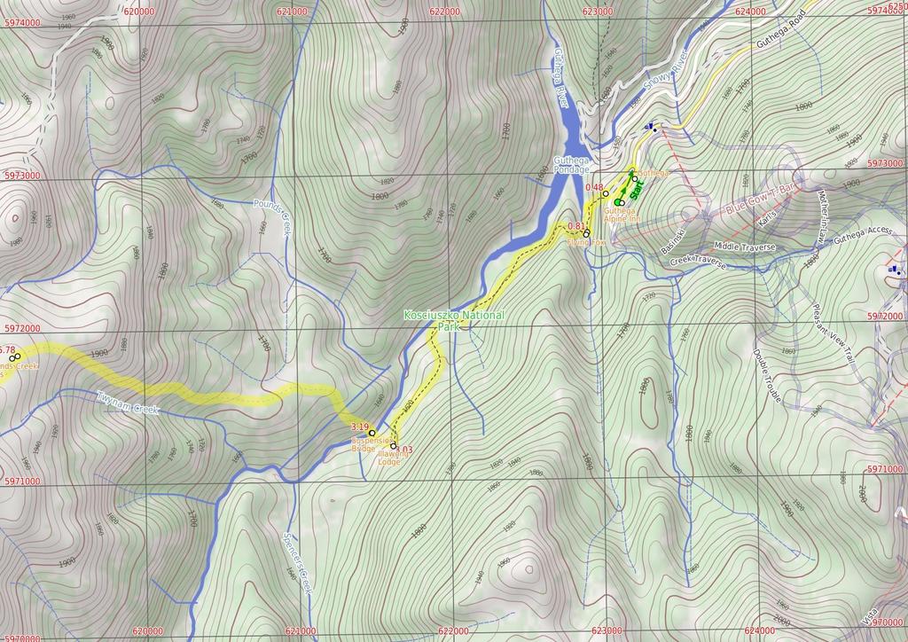
2 Covered in snow part of the year Before You walk This walk leads through an extreme alpine environment and all walkers must be well prepared. During summer, be prepared for both very hot and cold weather, high winds, rain, snow, extreme UV levels and some sections of snow or ice on the ground. Before starting this walk, check advice with Snowy Region Visitor Information Centre (2) , the weather forecast and the snow conditions then change your plans as needed. These notes, grades and walking times have been written for use in the summer months only. Between May and the end of October, this walk is likely to be covered in snow/ice, visitors should be carrying and be prepared to use snowshoes or cross country skis. When there is a chance of significant snow on the ground, visitors will need particularly strong navigation and snowcraft skills - tracks and signage may not be visible. For most visitors, it is best to consider this walk closed during the colder months. Bushwalking is fun and a wonderful way to enjoy our natural places. Sometimes things go bad, with a bit of planning you can increase your chance of having an ejoyable and safer walk. Before setting off on your walk check Guthega Guthega is a relatively small township, north of Perisher, and comprises mostly of hotel and lodge-style buildings. The most popular service in town is the Guthega Alpine Inn, open year round. The town is remote and access is by an all-weather dirt road. There are great views over the main range and the Guthega Pondage (part of the Snowy River Scheme). Guthega offers a great place to ski in winter, and to holiday in summer. In summer, there is plenty of walking, mountain biking, fishing and relaxing to be done. Walkers please note - there is no public water supply in the township, please fill water bottle before coming (or be willing treat and use the creek water). Guthega Alpine Inn Guthega Alpine Inn is on Guthega Road, about 5 metres past the base of the chairlift and 'Guthega Centre'. The hotel provides a yearround service including accommodation and meals. The hosts are friendly and the hotel provides a great base for walkers and other holiday makers. Please phone and book ahead for meals and accommodation. Phone More info. Flying Fox This metal flying fox was put in place to provide a safer option for crossing Blue Cow Creek when the water rises over the rocks. There are many flying foxes in the area to help people cross creeks, especially useful during snow melt when water is cold, deep and fastmoving. In 21, a metal bridge was installed over this creek, parallel to the flying fox, and the bridge is now the safest way to cross. 1) Weather Forecast (BOM Snowy Mountains District) 2) Fire Dangers (Monaro Alpine, Southern Slopes) 3) Park Alerts (Kosciuszko National Park) 4) Research the walk to check your party has the skills, fitness and equipment required 5) Agree to stay as a group and not leave anyone to walk solo Think before you TREK The 'Think before you TREK' program developed by NSW Police & NPWS promotes the benefits of planning ahead for your bushwalking trip by using an easy to remember acronym: adequate supplies of food, water, navigation and first T Take aid equipment. your planned route and tell friends and family when R Register you expect to return. beacon (PLB's) should be carried on walks with E Emergency significant gaps in mobile coverage (check terrain profile). to your planned route and follow the map and walking K Keep trails. Topo Maps The maps provided on wildwalks are helpful, but there are times where you may need maps covering a broader area. Maps that cover this walk include; 1:25 Map Series:85252S PERISHER VALLEY, 85241N CHIMNEYS RIDGE 1:1 Map Series:8525 KOSCIUSZKO, 8524 JACOBS RIVER Grade This walk has been graded using the AS The overall grade of the walk is dertermined by the highest classification along the whole track. 5 Grade 5/6 Experienced only Length 25.8 km One way Time 2 Days Quality of track Rough unclear track (5/6) Signs No directional signs (5/6) Experience Required High level of bushwalking experience recommended (5/6) Weather Forecast, unforecast storms and severe weather likely to have an impact on your navigation and safety (5/6) Infrastructure No facilities provided (5/6) * This walk passes through very remote areas and sections have no visible track. At least one person in your group should have training and experience in off track walking and navigation. Even with these notes and a GPS these extra skills and equipment are required.
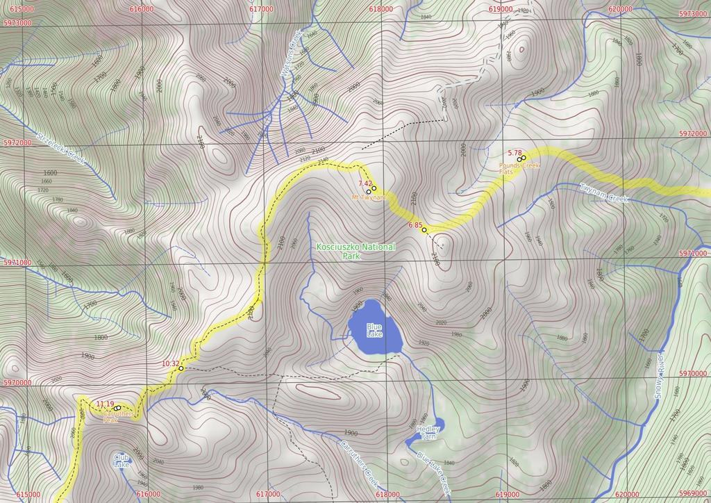
3 Are you ready to have fun? Please ensure you and your group are well prepared and equipped for all possible hazards and delays. Check park closures, weather information and Fire Danger Rating before setting out. Optional side trips and alternate routes noted are not included in this walks overall grade, length or time estimate. Please allow extra time for resting and exploring areas of interest. The authors, staff and owners of wildwalks take care in preparing this information but will not accept responsibility for any inconvenience, loss or injury you may experience. Please take care, have fun - Happy Walking. Experainced walkers only: This walk passes through very remote areas and sections have no visible track. At least one person in your group should have training and experience in off track walking and navigation. Even with these notes and a GPS these extra skills and equipment are required. Getting there Traveling by car is the only practical way to get to Car park below Guthega Alpine Inn (gps: , ). Car: A park entry fee is required for driving into the park. Traveling by car is the only practical way to get back from Bottom of Kosciuszko Express chairlift (gps: , ). Car: A park entry fee is required for driving into the park. Find up to date and more information inlcuding; travel directions, weather, park closures and walker feedback at Covered in snow part of the year This walk leads through an extreme alpine environment and all walkers must be well prepared. During summer, be prepared for both very hot and cold weather, high winds, rain, snow, extreme UV levels and some sections of snow or ice on the ground. Before starting this walk, check advice with Snowy Region Visitor Information Centre (2) , the weather forecast and the snow conditions then change your plans as needed. These notes, grades and walking times have been written for use in the summer months only. Between May and the end of October, this walk is likely to be covered in snow/ice, visitors should be carrying and be prepared to use snowshoes or cross country skis. When there is a chance of significant snow on the ground, visitors will need particularly strong navigation and snowcraft skills - tracks and signage may not be visible. For most visitors, it is best to consider this walk closed during the colder months. Guthega Guthega is a relatively small township, north of Perisher, and comprises mostly of hotel and lodge-style buildings. The most popular service in town is the Guthega Alpine Inn, open year round. The town is remote and access is by an all-weather dirt road. There are great views over the main range and the Guthega Pondage (part of the Snowy River Scheme). Guthega offers a great place to ski in winter, and to holiday in summer. In summer, there is plenty of walking, mountain biking, fishing and relaxing to be done. Walkers please note - there is no public water supply in the township, please fill water bottle before coming (or be willing treat and use the creek water). Guthega Alpine Inn Guthega Alpine Inn is on Guthega Road, about 5 metres past the base of the chairlift and 'Guthega Centre'. The hotel provides a year-round service including accommodation and meals. The hosts are friendly and the hotel provides a great base for walkers and other holiday makers. Please phone and book ahead for meals and accommodation. Phone More info. Car park below Guthega Alpine Inn (48 m 1 mins) From the car park (just below Guthega Alpine Inn, on Guthega Rd, 5m past the Guthega Centre), the walk follows the concrete road down the hill, keeping the main valley to the left. The road passes a small stone building and light post, just before coming to an intersection with another road heading off to the left, below the building named 'Toibunga'. Turn sharp left: From the intersection, the walk follows the concrete road down the hill towards the dam. After about 1m, the track veers right at another intersection, following the lower track. The concrete track turns to the right, but this walk continues straight, onto the wide dirt management trail (between the small boulders). Soon the trail bends right and comes to an intersection with a bush track..48 Int. of Guthega road servicetrail and Flying fox t (33 m 9 mins) Turn left: From the intersection, the walk heads between the boulders and is fairly flat initially, then, near a snow gum, the track steps down steeply and then winds down the hill to a 'T' intersection above Blue Cow Creek. (There is broken glass along this section of track, left over from Snowy River Scheme Camps). Veer left: From the intersection, the walk initially steps over a small, eroded gap in the track and then heads upstream alongside Blue Cow Creek, keeping the creek to your right. Before long, the track comes closer to the creek, and reaches a rocky crossing with a bridge and a flying fox over the creek..81 Flying Fox This metal flying fox was put in place to provide a safer option for crossing Blue Cow Creek when the water rises over the rocks. There are many flying foxes in the area to help people cross creeks, especially useful during snow melt when water is cold, deep and fast-moving. In 21, a metal bridge was installed over this creek, parallel to the flying fox, and the bridge is now the safest way to cross..81 Blue Cow Creek crossing (2.2 km 5 mins) Turn right: From the intersection, the walk crosses the creek on the bridge next to the metal flying fox. The walk then follows the bush track on the other side as it climbs to the top of the ridge. From the top of the hill, the track then winds down towards the Snowy River then turns left and generally follows it upstream. Soon the walk crosses a small creek and continues up the other side, undulating through the valley, crossing several more small creeks. The track winds left, away from the Snowy River, to climb the short hill to Illawong Lodge. 3.3 Illawong Lodge In 1956, the year after the Guthega Dam was first filled, the Kosciuszko State Park Trust gave permission for the conversion of the then-dilapidated hut into the present simple lodge. The lodge is maintained by members of Illawong Ski Tourers and friends. The nearby suspension bridge over the Snowy River and the flying fox over Farm Creek were built by members of Illawong. NPWS now maintains the suspension bridge and a new bridge over Farm Creek which has replaced the flying fox. The lodge can be reserved by members of the general public - see illawong.asn.au. There is also a small emergency shelter in the base of the hut, on the western wall, with enough room for a few people to see out a blizzard, with some water, blankets and other emergency supplies. More info. 3.3 Illawong Lodge (16 m 4 mins) Turn right: From the west side of Illawong Lodge (where the emergency shelter is located), the walk heads down towards the creek following the bush track. The track winds through scrub, passing through a grass clearing along the way. The walk soon comes to a cable suspension bridge Suspension Bridge Constructed and maintained by Illawong Ski Tourers, and only a stone's throw from Illawong Lodge, this cable suspension bridge provides a safer way to cross the upper Snowy River. This provides the main access between Guthega and the Main Range. The bridge also provides great views of the valley Suspension bridge (2.6 km 1 hr 13 mins) Continue straight: From the suspension bridge, this walk crosses the Snowy River to the west bank and climbs the hill, tending to the left of the top of the hill, and continuing up through the thick scrub. This section of the walk their is not track please fan out and minimse your impact. The walk winds up the ridge line through some more shallow scrub, passing through a thin tree line. The walk continues around to the left side of the ridge, where it gets much steeper, staying high out of the gully (which is to your left). The walk continues to the top of the ridge where it is much rockier, next to the large flats near the headwaters for Pounds Creek Pounds Creek Flats Located in the far upper reaches of Pounds Creek, this large flat area on the side of the ridge makes a great place to camp. The plateau forms a shallow hanging swamp in the few months after winter, when the snow melts and pools in the area. This campsite is flat and sheltered from the wind by the mountain. Water supply from the creek is unreliable Pounds Creek flats (1.1 km 29 mins) Veer left: From the flats, this walk heads south-west, following the ridge line that runs up the steep hill. The walk winds up and around the left side of the flats towards Little Twynam, bending around to the right as it approaches the top, then climbing up into the saddle between Little Twynam and Mt Twynam Twynam saddle (58 m 13 mins) Turn right: From the saddle, this walk heads north up the grassy hill towards Mt Twynam, climbing up the steep hill and winding through rocky outcrops. The walk turns to the north-west and continuing up to the trig station at the top of Mt Twynam Mt Twynam Mt Twynam is the largest peak on the ridgeline that winds around behind Blue Lake. It was once the location of a trig station, which was used for navigation until it was taken down. The metal frame, which was the lower half of the station, still sits on the peak today Mt Twynam (2.9 km 1 hr 1 mins) Continue straight: From the top of the mountain, this walk heads north-west, away from Little Twynam. The walk winds down through the rocky outcrops onto the ridge line, where it meets the old management trail and follows it west along the ridge line. The trail heads anticlockwise around Blue Lake until coming around to the south. The walk continues down and along the trail until coming to the right-hand side of the last knoll. Continue straight: From near the top of the hill, the walk follows the old 4WD trail south-west, down along the ridge line. At the end of the ridge, the trail winds down the steep, grassy hill into the saddle and around behind a signpost to the intersection with the Main Range track Int of Main Range and Mt Twynam tracks (86 m 18 mins) Turn right: From the intersection, this walk follows the 'Main Range Track' sign across the saddle then uphill along the clear track. The track winds up along the ridge and in time comes to a rocky clearing on the eastern side of Carruthers Peak (where a short detour will reveal views down to Club Lake). Here the walk bends right and follows the clear track as it winds up the hill to the views at the top of Carruthers Peak.
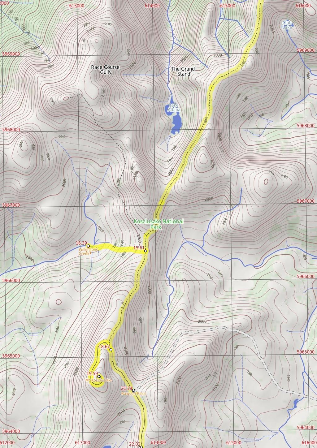
4 11.19 Carruthers Peak Carruthers Peak is a prominent mountain that is found along the Main Range track, from which you can see great views down over Club Lake and out across the valley to Charlotte Pass. Carruthers Peak was named after the NSW Minister for Lands and Premier, Joseph Carruthers. This name was given in 1991 by Richard Helms, who had previously named it Crummer Carruthers Peak (4.4 km 1 hr 33 mins) Continue straight: From the top of Carruthers Peak, this walk follows the clear track west as it winds down the ridge. After about 5m, the track passes an 'I3' survey marker (more good views) where the track bends left and follows the stone path and steps down the hill. At the end of the stone path, the track bends left and heads down the hill, over a few lengths of metal grate and comes to a saddle with good views down to Club Lake (on your left). The walk then continues across the saddle, following the clear track to soon pass the 'Rarest Alpine Plant Community' information sign. Heading around the side of the hill (keeping the valley to your right), the walk then comes to another rocky saddle. About 32m beyond this saddle, this track leads to a very faint intersection where the ridge (that leads to the northern end of Albina Lake) on the right meets the main track. Continue straight: From the intersection, the walk follows the gravel Main Range track south, keeping the valley and Albina Lake to your right. The track heads downhill and then winds around beside a rocky saddle (a short side trip to the left over the small rise reveals some views into the valley). This walk continues along the clear track as it traverses fairly gently around the side of the very steep hill. In a few places, the track has been cut into the rock and provides great views down into the Albina Lake - take care not to slip. The walk continues to another large saddle and just as the track starts to dip down past the saddle, the track comes to a faint intersection with an old management trail (leading to Lake Albina, on your right). Continue straight: From the intersection, the walk follows the rock-paved Main Range track south. The track steadily winds around the side of the hill (keeping the large valley to your left). After heading between a rocky outcrop, the track becomes gravel and starts to head over the ridge before gently winding down the hill. Just before flattening out on the large saddle, the track comes to a faint intersection (with the Muellers Peak and Mt Townsend tracks on your right) marked with a rock cairn (on your right). Veer left: From the intersection, this walk heads south along the main track to the low point in the saddle (where there is a faint intersection with a pad leading down to Wilkinsons Creek on your right) Int of Main Range and Wilkinsons creek track (78 m 16 mins) Turn right: From the low point in the saddle, this walk heads west, off the main track, over the grassy rise. Soon finding an overgrown management trail that leads down towards the creek at the bottom of the valley. The walk continues down the side of the hill passing through some low scrub to find many boulders and flat areas beside Wilkinsons Creek Wilkinsons Creek Wilkinsons Creek meanders through a beautiful and broad valley. Nestled in the valley between Mt Kosciuszko and Mt Townsend, this is a great spot to cool down or camp for a night. The large, flat, grassy plain, with a scattering of boulders, makes this great place to stay, although can be pretty exposed to westerly winds. You can often get great sunset views from the rocks at the western end. There are no facilities, please remember to use minimal impact techniques when visiting this area. Water is available from the creek. Camp more than 1m from the creek, and if staying for more than a day or two, move your camp to minimise the risk of damage. No fires - use fuel stoves only (there are a few gravelly areas to set your stove up to avoid destroying the grass) End of day 1 This is the planned overnight stay for the end of day 1, happy camping.
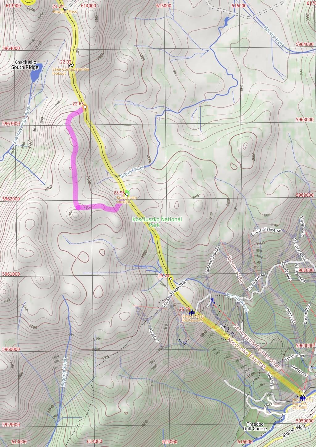
5 16.39 Wilkinsons creek (2.2 km 54 mins) Turn around: From the creek, the walk heads east, up the valley following the old overgrown management trail. The walk climbs up through the boulders through some low scrub to the grassy gap. Just over the rise this walk comes to a 'T' intersection with the Main Range Track. Turn right: From the intersection, this walk heads south along the clear track, climbing up out of the saddle and along the side of the hill, keeping the valley to your left. The walk heads up many stone steps for about 6m, then flattens out for a little while before coming to a clear and signposted threeway intersection. (Here, the track on the right leads up to the summit of Mt Kosciuszko.) Int of Main Range track and Kosciuszko path (97 m 23 mins) Turn sharp right: From the intersection, this walk follows the 'Mt Kosciuszko' sign uphill along the upper track. This track winds steadily up and around the peak of the mountain, passing a stone-paved section of track, and also a metal grate before climbing a few steps to the cairn at the peak of Mt Kosciuszko Mt Kosciuszko Mt Kosciuszko is the highest peak on the Australian continent, at 2228m above sea level. It was named by the Polish explorer Count Paul Edmund Strzelecki and named in honour of the Polish national hero General Tadeusz Ko?ciuszko. Now a popular tourist attraction, thousands of people walk up to the summit each year. On a clear day, the 36-degree views from the summit across the roof of Australia are fantastic. There are higher mountains elsewhere on Australian territory. 'The highest mountains in Australian Antarctic Territory are Mt McClintock (349 meters) and Mt Menzies (3355 meters).' Mt Kosciuszko (1.6 km 39 mins) Turn around: From the cairn at the peak of Mt Kosciuszko, this walk heads down the steps and past the information sign. The walk heads gently downhill along the gravel track then over a metal grate and a stone path, where the gravel path then leads the rest of the way around the side of the peak to come to the signposted intersection with the 'Main Range Track'. Veer right: From the intersection, this walk follows the gravel track towards 'Rawson Pass' gently downhill, keeping the main valley to your left. The track almost immediately passes an 'Alpine Walks' information sign and map as it continues south. After about 5m, the track becomes a stone path that leads a little further to the clearly signposted three-way intersection at 'Rawson Pass' Rawson Pass Rawson Pass is where the old Kosciuszko Road, from Charlotte Pass, meets the metal walkway from Thredbo. It is home to highest public toilet in Australia, this recently-added facility is perfectly positioned for those taking the walk up to the top of Kosciuszko. Rawson Pass is well signposted and 5m south east of Mt Kosciuszko (by straight line). There is also a place for to park mountain bikes for those cycling along the old road from Charlotte Pass Rawson Pass (79 m 14 mins) Veer right: From 'Rawson Pass', this walk follows the 'Kosciuszko Walk - Lake Cootapatamba Lookout' sign south along the metal walkway as it gently winds down along the side of the hill. Keeping Lake Cootapatamba on your right, the path soon leads up a short hill to find the signposted 'Lake Cootapatamba Lookout' Lake Cootapatamba lookout Situated on the Kosciuszko walk, this platform looks down over Lake Cootapatamba, in the valley on the western side of the path. This is a pleasant place to stop and enjoy the mountains and views Lake Cootapatamba lookout (6 m 12 mins) Continue straight: From the lookout, this walk follows the metal walkway heading south down the gentle hill, initially keeping the view to Lake Cootapatamba to your right. The path leads down the ridge across the saddle to find a faint intersection with a foot pad, where the spur from the rocky North Rams Head (on your right) meets the track Alternate Route Int of Kosciuszko path and North R (2.2 km 5 mins) Turn right: From the intersection, the walk heads south-west up and out of the saddle. The walk climbs up onto the ridge, then winds all the way along this ridge line (south), through heavily scattered rock outcrops, to the base of the North Rams Head. The walk then winds up through the large rocks to the peak of North Rams Head. Turn left: From the peak, the walk heads east towards the Kosciuszko path, initially climbing down through the large rocks to the base of the small mountain. The walk continues east, down the hill, winding through and around many rock outcrops and boulders, then through a grassy pass and down the steep hill. From here, the walk continues through the shallow scrub all the way to the intersection of the Kosciuszko path and the lookout walkway. Now Turn right to rejoin the main walk Int of Kosciuszko path and North Rams Head loop (1.3 km 28 mins) Continue straight: From the intersection, this walk heads south along the metal walkway, keeping Rams Head ridge line to your right. The walk follows the metal walkway past the 'Endangered Mammals live between boulders' sign then across the upper reaches of the Snowy River. Here the walk heads up this hill to find a three-way intersection of metal paths, with the Kosciuszko lookout track (on your left) Optional sidetrip to Kosciuszko lookout (5 m 1 mins) Turn sharp left: From the intersection, this walk heads northeast along the metal path that branches off the main path. The path leads a short distance up some steps to soon come to the metal platform at the Kosciuszko lookout. At the end of this side trip, retrace your steps back to the main walk then Veer left Kosciuszko lookout Kosciuszko lookout is about 3m off the main Kosciuszko walk, along a metal walkway. At the lookout, there is a larger platform with an information sign about how the landscape was formed over the years. Granting a great view of the Snowy Mountains to the summit of Mt Kosciuszko Int of Kosciuszko path and lookout walkway (1.3 km 31 mins) Continue straight: From the intersection, the walk follows the metal walkway south, up the hill (away from the lookout). The track leads over the gentle rise and soon comes to 'A rocky mountain home' information sign and a 'Thredbo 1.5km' tag pointing down the hill. Here the walk heads down a series of steps to mostly flatten out at the 'Flowers emerge with warmer weather' information sign. Soon after this, the walk comes to a 'Plant communities - keeping a low profile' information sign, marking an intersection (where the snow-pole line on your left joins the main track). Continue straight: From the intersection, this walk follows the metal walkway south, downhill, soon passing a 'Plant communities - keeping a low profile' information sign and a 'Thredbo 1.km' badge welded to the track. The walk continues to follow this track down the hill, then past the 'Everything is connected' information sign and the large 'Kosciuszko Walk' sign. At the bottom of the steps, this walk comes to an intersection (with a minor track on your left) just before a bridge at a lovely spot beside the creek Start of metal walkway (55 m 9 mins) Continue straight: From the end of the metal walkway, this walk crosses the creek using the metal bridge and follows the paved path up and over the gentle rise, heading towards the ski lifts. Soon the path leads past a small alcove with two information signs. Here the walk continues along the path a short distance to find a signposted intersection with the 'Dead Horse Gap' track (on your right), where there is also an arrow pointing back to 'Mt Kosciuszko Lookout'. Continue straight: From the intersection, this walk follows 'Eagles Nest Restaurant' sign down along the paved path towards the chairlift building. The path gently winds down the hill to find the top of the 'Kosciuszko Express' chairlift and the Eagles Nest Restaurant Eagles Nest Restaurant This is Australia's highest restaurant, providing great food and outstanding views. It is easily accessible, nestled on the mountain directly opposite the top of the Kosciuszko Express chairlift, and is open year-round. For more information, call (2) Kosciuszko Express Chairlift This is one of the few lifts operating in the summer months at Thredbo, and is made quite popular by thousands of people walking to the summit of Mt Kosciuszko each year. Lift tickets can be purchased from the store at the bottom of the chairlift. Lift tickets are $31 return ($25 one way) per person. This lift is generally closed during November and May for maintenance each year, but the the Snowgum chair can be used at this time instead, this will add extra walking time to you walk. More info Top of Kosciuszko Express chairlift (1.9 km 2 mins) Turn left: From the top terminal, walk up to the platform as directed by the chairlift operator and sit down in the seat, letting it scoop you up. Once seated, pull down the safety bar and enjoy the ride down to Thredbo village. :) After alighting at the bottom, this walk turns right to almost immediately turn left down a set of steps and heads through the building to find an open area at the front of the 'Valley Terminal' building where there are some large maps.
6
7
8
9
10 Summary navigation sheet for the Guthega to Thredbo camping overnight at Wilkensons Creek km From. Car park below Guthega Alpine Inn , (GR Perisher Valley, ) Int. of Guthega road servicetrail and Flying fox track , (GR Perisher Valley, 23729) m 1 mins 33 m 9 mins Blue Cow Creek crossing , (GR Perisher Valley, ) Illawong Lodge , (GR Perisher Valley, ) Suspension bridge , (GR Perisher Valley, ) Pounds Creek flats , (GR Perisher Valley, ) Twynam saddle , (GR Perisher Valley, ) Mt Twynam , (GR Perisher Valley, ) Int of Main Range and Mt Twynam tracks , (GR Perisher Valley, 16371) Carruthers Peak , (GR Perisher Valley, ) Int of Main Range and Wilkinsons creek track , (GR Perisher Valley, ) End of day , (GR Perisher Valley, ) Wilkinsons creek , (GR Perisher Valley, ) Int of Main Range track and Kosciuszko path , (GR Perisher Valley, ) Mt Kosciuszko , (GR Perisher Valley, ) Rawson Pass , (GR Perisher Valley, ) Lake Cootapatamba lookout , (GR Perisher Valley, ) Int of Kosciuszko path and North Rams Head loop , (GR Perisher Valley, ) Int of Kosciuszko path and North Rams Head loop , (GR Perisher Valley, ) km 5 mins 16 m 4 mins 2.6 km 1 hr 13 mins 1.1 km 29 mins 58 m 13 mins 2.9 km 1 hr 1 mins 86 m 18 mins 4.4 km 1 hr 33 mins 78 m 16 mins m Up/Dwn Length Initial directions (Use full tracknotes and maps for more detail) 2.2 km 54 mins 97 m 23 mins 1.6 km 39 mins 79 m 14 mins 6 m 12 mins 2.2 km 5 mins 1.3 km 28 mins From the car park (just below Guthega Alpine Inn, on Guthega Rd, 5m past the Guthega Centre), the walk follows the concrete road down the hill, keeping the main valley to the left. Turn left: From the intersection, the walk heads between the boulders and is fairly flat initially, then, near a snow gum, the track steps down steeply and then winds down the hill to a 'T' intersection above Blue C... Turn right: From the intersection, the walk crosses the creek on the bridge next to the metal flying fox. Turn right: From the west side of Illawong Lodge (where the emergency shelter is located), the walk heads down towards the creek following the bush track. Continue straight: From the suspension bridge, this walk crosses the Snowy River to the west bank and climbs the hill, tending to the left of the top of the hill, and continuing up through the thick scrub. Veer left: From the flats, this walk heads south-west, following the ridge line that runs up the steep hill. Turn right: From the saddle, this walk heads north up the grassy hill towards Mt Twynam, climbing up the steep hill and winding through rocky outcrops. Continue straight: From the top of the mountain, this walk heads north-west, away from Little Twynam. Turn right: From the intersection, this walk follows the 'Main Range Track' sign across the saddle then uphill along the clear track. Continue straight: From the top of Carruthers Peak, this walk follows the clear track west as it winds down the ridge. Turn right: From the low point in the saddle, this walk heads west, off the main track, over the grassy rise. This is the planned overnight stay for the end of day 1, happy camping. Turn around: From the creek, the walk heads east, up the valley following the old overgrown management trail. Turn sharp right: From the intersection, this walk follows the 'Mt Kosciuszko' sign uphill along the upper track. Turn around: From the cairn at the peak of Mt Kosciuszko, this walk heads down the steps and past the information sign. Veer right: From 'Rawson Pass', this walk follows the 'Kosciuszko Walk - Lake Cootapatamba Lookout' sign south along the metal walkway as it gently winds down along the side of the hill. Continue straight: From the lookout, this walk follows the metal walkway heading south down the gentle hill, initially keeping the view to Lake Cootapatamba to your right. Alternate Route Int of Kosciuszko path and North Rams Head loop. Turn right: From the intersection, the walk heads south-west up and out of the saddle. Continue straight: From the intersection, this walk heads south along the metal walkway, keeping Rams Head ridge line to your right.
11 Summary navigation sheet for the Guthega to Thredbo camping overnight at Wilkensons Creek km From Int of Kosciuszko path and lookout walkway , (GR Perisher Valley, 14562) Int of Kosciuszko path and lookout walkway , (GR Perisher Valley, 14562) Start of metal walkway , (GR Perisher Valley, 1569) Top of Kosciuszko Express chairlift , (GR Perisher Valley, 15365) Powered by TCPDF ( Up/Dwn Length Initial directions (Use full tracknotes and maps for more detail) m 1 mins 1.3 km 31 mins 55 m 9 mins 1.9 km 2 mins Optional sidetrip to Kosciuszko lookout. Turn sharp left: From the intersection, this walk heads north-east along the metal path that branches off the main path. Continue straight: From the intersection, the walk follows the metal walkway south, up the hill (away from the lookout). Continue straight: From the end of the metal walkway, this walk crosses the creek using the metal bridge and follows the paved path up and over the gentle rise, heading towards the ski lifts. Turn left: From the top terminal, walk up to the platform as directed by the chairlift operator and sit down in the seat, letting it scoop you up.
Guthega to Mt Twynam. 2183m. 1583m. 6 hrs 45 mins 14.8 km Return. Experienced only. 913m
 Guthega to Mt Twynam 6 hrs 45 mins 14.8 km Return Experienced only 5 913m This walk starts from Guthega and makes its way along the Snowy River to the Illawong Lodge, via the Blue Cow Creek flying fox.
Main Range Track - Loop from Charlotte Pass camping near Mt Townsend
 Main Range Track - Loop from Charlotte Pass camping near Mt Townsend 2 Days Experienced only 27.7 km Circuit 5 1260m This great overnight walk starts from Charlotte Pass and provides access to some of
Main Range Walk - Charlotte Pass to Mount Kosciuszko
 Main Range Walk - Charlotte Pass to Mount Kosciuszko 9 hrs Hard track 21.9 km Circuit 4 920m This full day walk explores some of the greatest alpine country on offer in NSW. The walk grants views of Blue,
Main Range Circuit from Guthega
 Main Range Circuit from Guthega 4 Days Experienced only 45 km Circuit 5 2317m This four day walk explores the Kosciuszko National Park, covering many of the key features of the park between Guthega and
Merritts Traverse. 1928m
 Merritts Traverse 3 hrs Hard track 5.8 km Circuit 4 167m This walk starts with a scenic journey to the top of the hill on the chairlift. Starting along Merritts Nature walk, this walk soon detours down
Congewai Track Head (East) to Watagan Headquarters
 to Watagan Headquarters") Congewai Track Head (East) to Watagan Headquarters 7 hrs Hard track 17.2 km One way 4 973m This full day walk starts from the Congewai valley trackhead (east) and follows the Great North Walk up into the
Congewai Track Head (East) to Watagan Headquarters 7 hrs Hard track 17.2 km One way 4 973m This full day walk starts from the Congewai valley trackhead (east) and follows the Great North Walk up into the
Victoria Falls Lookout to Blue Gum Forest
 Victoria Falls Lookout to Blue Gum Forest 8 hrs Experienced only 13.8 km One way 5 112m This long day-walk follows a remote track down from Victoria Falls lookout, passing the waterfall, and into the Grose
Erskine Creek via Pisgah Rock and Jack Evans
 Erskine Creek via Pisgah Rock and Jack Evans 4 hrs 30 mins 7.1 km Circuit Very experienced only 6 421m This walk visits some great lookouts and explores the lower section of Erskine Creek. Most of the
Nature Track. 900m. 789m. 2 hrs 3.1 km Circuit. Hard track 238m. Blue Mountains National Park
 Nature Track 2 hrs 3.1 km Circuit Hard track 238m Largely following the ridges around the top edge of Wentworth Falls, this track is incredibly beautiful. After taking in the great views at Edinburgh Castle
Staples Lookout to Mt Wondabyne loop
 Staples Lookout to Mt Wondabyne loop 4 hrs 3 mins 1.8 km Circuit Hard track 337m This walk starts and finishes at Staples Lookout, on Woy Woy Rd. The walk follows sections of the Great North Walk around
Leura Cascades to Gordon Falls Reserve
 Leura Cascades to Gordon Falls Reserve 1 hr 15 mins 1.8 km One way Moderate track 200m From Leura Park to Gordon Falls Park, this diverse walk offers fantastic views of the Jamison Valley, as well as two
Abbotts Falls Walking Track
 Abbotts Falls Walking Track 3 hrs 7.3 km Circuit Hard track 329m This circuit takes you through both dry and moist forest, using a combination of walking trails and wider tracks. The side trip to the dammed
Berowra Waters to Cowan Station
 Berowra Waters to Cowan Station 3 hrs 30 mins 7.2 km One way Hard track 597m This is a hilly walk out of the beautiful Berowra Waters valley to Cowan Station. There are many wide views across Berowra Creek
Girrakool to Wondabyne station
 Girrakool to Wondabyne station 4 hrs Hard track 9.5 km One way 4 438m This walk starts from the Girrakool picnic area and winds south, through the Brisbane Waters National Park. The walk crosses some long
Mt Kuring-gai Track to Berowra station
 Mt Kuring-gai Track to Berowra station 4 hrs 15 mins 9.7 km One way Hard track 4 553m This walk explores three valleys, with great displays of wild flowers in spring, and some nice sandstone overhangs.
Dadder Cave and Jack Evans track
 Dadder Cave and Jack Evans track 2 Days 10.3 km Circuit Very experienced only 535m This fairly short overnight walk is a great way to explore Erskine Creek. The walking along Erskine creek is mostly off
Scenic Railway to Ruined Castle
 Scenic Railway to Ruined Castle 7 hrs 30 mins 12.4 km Return Hard track 4 963m This is a very popular, full day walk, in the Katoomba Area, offering great views of the valley. The walk follows the edge
Girrakool to Wondabyne station via Pindar caves
 Girrakool to Wondabyne station via Pindar caves 7 hrs 30 mins 18.1 km One way Experienced only 5 741m This walk starts from the Girrakool picnic area and winds south, following Piles creek into the Brisbane
Jerusalem Bay Track (Cowan to Brooklyn)
") Jerusalem Bay Track (Cowan to Brooklyn) 5 hrs 30 mins 13.4 km One way Hard track 4 654m This Cowan to Brooklyn Station walk is a popular section of the Great North Walk, with scenery ranging from foreshore
Jerusalem Bay Track (Cowan to Brooklyn) 5 hrs 30 mins 13.4 km One way Hard track 4 654m This Cowan to Brooklyn Station walk is a popular section of the Great North Walk, with scenery ranging from foreshore
Victoria Falls to Blackheath Station
 Victoria Falls to Blackheath Station 2 Days Experienced only 22.2 km One way 5 1561m This is a fantastic overnight walk with a sleep in Acacia Flats camping area. The Grose Valley, with its views of the
Victoria Falls and Grose Valley to Blackheath Station
 Victoria Falls and Grose Valley to Blackheath Station 3 Days Experienced only 22.5 km One way 5 158m This walk explores a fantastic section of the Grose Valley. Starting above Victoria Falls, the walk
Berowra to Cowan via Berowra Waters
 Berowra to Cowan via Berowra Waters 6 hrs Hard track 12.9 km One way 4 884m With train station at each end this walk explores the ridges and valleys around Berowra Waters. There are plenty of excellent
Wentworth Pass. 893m. 535m. 4 hrs. Hard track 5.1 km Circuit. 692m
 Wentworth Pass 4 hrs Hard track 5.1 km Circuit 4 692m This walk offers a great way to explore the magical, upper section of the Valley of the Waters. The walk starts and finishes at Conservation Hut, which
National Pass. 893m. 665m. 3 hrs 30 mins 4.6 km Circuit. Hard track 773m. Blue Mountains National Park
 National Pass 3 hrs 3 mins 4.6 km Circuit Hard track 773m 4 This walk offers fantastic views of the Jamison Valley and the surrounding cliffs. Take time to explore the historic and very scenic ledge halfway
Gibberagong Track. 169m
 Gibberagong Track 2 hrs 30 mins 6.5 km One way Hard track 4 180m Starting in suburban Wahroonga, this wellmaintained track follows Cockle Creek down to Bobbin Head in the Ku-ring-gai Chase National Park.
Somersby to Yarramalong via Stringy Bark Point
 Somersby to Yarramalong via Stringy Bark Point 2 Days Hard track 26.7 km One way 4 1201m This section of the Great North Walk starts form the Somersby General Store and follows the Great North Walk north
Patonga to Staples Lookout
 Patonga to Staples Lookout 6 hrs 3 mins 17 km One way Hard track 4 72m This great walk explores much of the main ridge ridge running through Brisbane Water National Park. The walk visits a number of great
Crosslands to Berowra Waters return
 Crosslands to Berowra Waters return 6 hrs Hard track 13.7 km Return 4 1005m This return walk starts from the Crosslands Reserve and follows the Great North Walk along Berowra creek. The walk includes some
Hornsby station to Crosslands
 Hornsby station to Crosslands 6 hrs 45 mins 16.1 km One way Hard track 4 938m This section of the Great North Walk starts from Hornsby train station and winds down along the Blue Gum Walk into Fishponds.
Blackheath to Blue Gum loop
 Blackheath to Blue Gum loop 2 Days Hard track 24.1 km Circuit 4 1335m This walk is great for fit people getting into overnight walking, with its fantastic scenery and nostalgia as a classic overnighter.
Crosslands to Cowan. 220m
 Crosslands to Cowan 7 hrs 30 mins 14 km One way Hard track 4 1103m This section of the Great North Walk starts from the Crosslands camping area and winds north alongside Berowra creek, passing through
Patonga to Wondabyne station via Mt Wondabyne
 Patonga to Wondabyne station via Mt Wondabyne 7 hrs 3 mins 19.5 km One way Hard track 4 861m This walk explores some grand views, pleasant cascades, varied bushland and remote areas of Brisbane Waters
Leura to Katoomba via Dardanelles Pass
 Leura to Katoomba via Dardanelles Pass 4 hrs 6.6 km One way Hard track 697m With approximately equal parts cliff-walk and forest track, this track truly shows what the cliff edges of the Jamison Valley
Patonga to Wondabyne station via Pindar Caves overnight
 Patonga to Wondabyne station via Pindar Caves overnight 2 Days Experienced only 28.1 km One way 5 1164m This overnight hike starts from Patonga beach and winds along a section of the Great North Walk,
Lady Carrington Drive
 Lady Carrington Drive 3 hrs 45 mins 9.7 km One way Moderate track 3 266m This walk follows the historic Lady Carrington Drive alongside the Hacking River. The old road is closed to traffic and provides
Out and about at Geehi
 Geehi Geehi Flats is a large area of flat floodplain on the banks of the Swampy Plains River. Located within Kosciuszko National Park, it is home to a popular campsite in summer for people wanting to enjoy
The Prince Henry Cliff Walk
 The Prince Henry Cliff Walk 3 hrs 30 mins 6.8 km One way Moderate track 3 575m Going from Katoomba to Leura, this walk covers the top of the cliff line and most of the major lookouts. With brilliant vistas
Katoomba to Wentworth Falls via the Jamison Valley
 Katoomba to Wentworth Falls via the Jamison Valley 2 Days Experienced only 29.2 km One way 5 2135m This is the two day version of this popular and challenging walk. This walk passes popular sights including
Somersby to the Basin Campsite
 Somersby to the Basin Campsite 3 Days Hard track 47.4 km One way 4 2032m This three day walk starts at the Somersby General Store and follows the Great North Walk, heading north, into the the Jilliby State
Wondabyne station to Somersby Store
 Wondabyne station to Somersby Store 10 hrs Hard track 26.2 km One way 4 1164m This walk, following a section of the Great North Walk, starts from the Wondabyne train station and winds north, into the Brisbane
Berowra to Hornsby. 9 hrs 18 mins 22.6 km One way. Hard track. 1423m
 Berowra to Hornsby 9 hrs 18 mins 22.6 km One way Hard track 4 1423m One of the longer day walks in Berowra Valley National Park, this walk mostly follows Berowra Creek along the Great North Walk. Excellent
Cowan to Wondabyne station via Patonga rest area
 Cowan to Wondabyne station via Patonga rest area 2 Days Hard track 33.4 km One way 4 1523m This section of the Great North Walk starts from Cowan train station and wanders past the majestic Jerusalem Bay
Victoria Falls and Grose Valley to Blackheath Station
 This walk explores a fantastic section of the Grose Valley. Starting above Victoria Falls, the walk explores the cascades before dropping into the valley for the first nights rest at Burra Korain campsite.
Crosslands to Brooklyn
 Crosslands to Brooklyn 2 Days Hard track 27.4 km One way 4 1757m From the Crosslands Reserve, this walk heads along the Great North Walk via Berowra Waters, Cowan, Jerusalem Bay and onto Brooklyn. This
Western Commission Track to Dubbo Gully
 This two day walk follows a series of historic roads along clear and wide management trails. This walk explores the great views from Western Commission Track, the sandstone handicraft on the Old Great
GOLDEN EARS PROVINCIAL PARK
 GOLDEN EARS PROVINCIAL PARK Trail Information as of October 10 th 2015 Do not underestimate the mountainous wilderness of Golden Ears Provincial Park. The combination of rugged terrain and rapidly changing
Gordon to Hornsby (overnight at Scout camp)
") Gordon to Hornsby (overnight at Scout camp) 2 Days Hard track 25.8 km One way 4 125m This overnight walk starts from Gordon train station and winds through bush filled valleys to Hornsby station. From
Gordon to Hornsby (overnight at Scout camp) 2 Days Hard track 25.8 km One way 4 125m This overnight walk starts from Gordon train station and winds through bush filled valleys to Hornsby station. From
Trail Phasing Plan. Note: Trails in the Clear Creek Canyon area (Segments will be finalized in the future to minimize wildlife impacts
 Note: Trails in the Clear Creek Canyon area (Segments 2 5 and a future JCOS connection) will be finalized in the future to minimize wildlife impacts Trail Phasing Plan P Parking 3 Easy Trail Intermediate
Route #2) Mt. Massive - Southwest Slopes
 Mt. Massive - Southwest Slopes") Route #2) Mt. Massive - Southwest Slopes Difficulty: Class 2 Ski: Advanced, D6 / R2 / III Exposure: Summit Elevation: Trailhead Elevation: Elevation Gain: Round-trip Length: Trailhead: County Sheriff:
Route #2) Mt. Massive - Southwest Slopes Difficulty: Class 2 Ski: Advanced, D6 / R2 / III Exposure: Summit Elevation: Trailhead Elevation: Elevation Gain: Round-trip Length: Trailhead: County Sheriff:
ID: 283 Distance: 6.2 miles Height gain: 500 Metres Map: Explore OL 19 Contributor David and Chris Stewart
 Walkingworld Wild Boar Fell ID: 283 Distance: 6.2 miles Height gain: 500 Metres Map: Explore OL 19 Contributor David and Chris Stewart Features Birds, Great Views, Hills or Fells Description: Wild Boar
Podcast 31 - The Australian Alps - A Trip to Thredbo
 Podcast 31 - The Australian Alps - A Trip to Thredbo by Rob McCormack - Friday, January 03, 2014 http://slowenglish.info/?p=918 Learn English while learning about daily life in Australia, with Rob McCormack
1. Waterfall Gully Mt Lofty. 5 Of the Best Hikes in Adelaide
 Adelaide is a beautiful city, and one of the most incredible things about Adelaide is the quality of bushwalking available on the suburban fringe. It is surrounded by the Mt Lofty Ranges, and much of the
Slad over to Pitchcombe and back
 The walk climbs up from Slad over Wickridge Hill, descends to near Pitchcombe, then climbs back over Wickridge hill and round the back of Slad. Page 1 Start Point: SO 8718 0732 The Woolpack, Slad Length:
Overnight Guided Walks
 Overnight Guided Walks Day One Climb through a forest of snow gums from Dead Horse Gap, before following the ridge line toward Mount Kosciuszko. Head for our base camp and enjoy the hospitality of our
Skiing and Snowshoes on Un-groomed Fernan Saddle Terrain
 Skiing and Snowshoes on Un-groomed Fernan Saddle Terrain Three ski or snowshoe routes are available from the Fernan Saddle Parking Lot which either do not cover routes ordinarily groomed for snow machine
The Mendip Way. Route Directions and Maps Uphill to Wells
 The Mendip Way Route Directions and Maps Uphill to Wells Website: www.mendiphillsaonb.org.uk Email: mendip@mendiphillsaonb.org.uk Facebook & Twitter: @MendipHillsAONB Phone: 01761462338 1 Uphill to Loxton
Thornleigh to Cowan. 2 Days. Hard track 35.9 km One way. 2337m
 Thornleigh to Cowan 2 Days Hard track 35.9 km One way 4 2337m Following the Great North Walk and Berowra Creek through Berowra Valley Regional Park, this walk cuts straight through the length of the Park.
IRON BARK and COLENSO HUTS 260 Series Map: 1:50, U21 NZ Grid GPS: Geodetic Datum 1949
 IRON BARK and COLENSO HUTS 260 Series Map: 1:50,000 260-U21 NZ Grid GPS: Geodetic Datum 1949 Topo50 Map: BK36 Taoroa Junction GPS: on WGS84 How to get to START: Exit Taupo on SH1 down the lake to Turangi
Wicklow Mountains Path Survey
 Wicklow Mountains Path Survey Ballinacor Croaghanmoira Fananierin Start to Finish: T 11723 86602 to T 11175 89057 Altitude (lowest highest): 385m 664m Weather: Hot Access: Coolgarrow forest entrance Surveyed
Beautiful Walks from the Blue Ball Inn
 Walk No. 5 RIVER VALLEYS AND MOOR Countisbury, Watersmeet, Hillsford Bridge, Cheriton, Shilstone Hill, Rockford and Chiselcombe. 8.5 MILES APPROX. Walking time four and a half hours approx. OS 1;25,000
beach. Make the ford and follow the trail out to the junction with Red Creek Tr in an open grassy area.
 Description: This is a moderate to slightly strenuous 22.8 mile backpack (add 2.6 miles if you do the packless out and back to the Lion s Head) that will have you exploring nearly every thing that is The
Leaden Boot Challenge ROUTE INSTRUCTIONS
 Leaden Boot Challenge ROUTE INSTRUCTIONS Section 1 Alstonefield to Ilam From the village hall car park turn R then L and pass through the village keeping to the R to enter Church Street. Pass the Church
Self-Guided Walk Langdale Pikes. Start & Finish: NT car park (free to members) at Sticklebarn - on the right just beyond the New Dungeon Ghyll hotel.
 at Sticklebarn - on the right just beyond the New Dungeon Ghyll hotel.") Self-Guided Walk Langdale Pikes Key Information These mountains form a collection of spires and cliffs on the north side of Langdale. This walk visits four of the main tops Pavey Ark, Harrison Stickle,
Self-Guided Walk Langdale Pikes Key Information These mountains form a collection of spires and cliffs on the north side of Langdale. This walk visits four of the main tops Pavey Ark, Harrison Stickle,
Leaden Boot Challenge 2016 ROUTE INSTRUCTIONS
 Leaden Boot Challenge 2016 ROUTE INSTRUCTIONS Section 1 Alstonefield to Ilam (CP2) From the village hall car park turn R then L and pass through the village keeping to the R to enter Church Street. Pass
Tiger Mountain State Forest:
 98 60 hikes within 60 miles: SEATTLE 20 Tiger Mountain State Forest: West Tiger Mountain Three Loop i KEY AT-A-GLANCE INFORMATION Length: 5.1 miles round-trip Configuration: Loop Difficulty: Moderate difficult
Baggy Point, Croyde, North Devon
 Baggy Point, Croyde, North Devon A walk using the South West Coast Path that is likely to be suitable for people with impaired mobility or with a pushchair, wheelchair, or mobility scooter. The Coast Path
Waiau Pass Track. (Map 92, 91, 90, 89, 88, 87)
") Waiau Pass Track (Map 92, 91, 90, 89, 88, 87) Southern Start Northern End Distance Time Track Standard Boyle Village St Arnaud Village 115.5km 5-8 days Tramping track At 1870m, Waiau Pass is the most likely
Waiau Pass Track (Map 92, 91, 90, 89, 88, 87) Southern Start Northern End Distance Time Track Standard Boyle Village St Arnaud Village 115.5km 5-8 days Tramping track At 1870m, Waiau Pass is the most likely
Below is an example of a well laid-out template of a route card used by the Sionnach Team which is a good format to begin with.
 Route Card A route card is used as a navigational aid to hill walkers by setting out a step by step plan for an intended hike. It is good practice to make out a route card before every hike you or your
Lake Wissota Access Locations within the LaFayette Township. By Chad Martin
 Lake Wissota Access Locations within the LaFayette Township By Chad Martin Anson/ Wissota Access Point # 1 Road: 195 th St. Associated Fire Numbers: 13294 Defining Characteristics: Forested from road
Hiking Las Vegas.com
 Hike: Mt. Wilson via First Creek Canyon route Trailhead: First Creek marked Distance: 10 miles up and back Elevation gain: 3,400 feet Elevation of Peak: 7,070 feet Time: 7 to 9 hours (up and back) Difficulty:
Lava Mountain Trail Distance: Elevation Range: Trail Type: Difficulty: Season: Driving Distance: Driving Time: USGS Maps: Pros Cons
 Lava Mountain Trail Distance: 13.4 miles (including the side trip to North Star Lake) Elevation Range: 5900'-8330' Trail Type: singletrack Difficulty: moderate Season: late June-October Driving Distance:
Bewl Water & the High Weald
 1 Bewl Water & the High Weald Stonegate station - Stonegate - Wallcrouch - Newbarn - Cousley Wood - Wood's Green - Wadhurst station Length: 9 ½ miles (15.3km) Underfoot: Large portions of this path are
TUPPER DESIGNATED ACCESS ROUTE
 TUPPER DESIGNATED ACCESS ROUTE 1 FOR ACCESS/EGRESS TO CONNAUGHT, LOOKOUT, STONE ARCH, PORTAL PATHS AND TUPPER TRAVERSE EGRESS Length: 2.6km Vertical Gain: +162m / -83m (Values are for access. For egress,
Telluride-to-Moab Alternative Singletrack Options
 Telluride-to-Moab Alternative Singletrack Options Day 1 Day 1 Alternate 1: Galloping Goose to Deep Creek. 18.4 miles, ascent 3,530ft, descent 1,388ft. This is fun, flowey, moderate to intermediate singletrack
Camp Jack Wright PERMANENT ORIENTEERING COURSE (2004)
") Camp Jack Wright PERMANENT ORIENTEERING COURSE (2004) WHAT IS ORIENTEERING? The skill which enables a person to navigate with a map. In the competitive sport, the winner is the person who finishes in the
Camp Jack Wright PERMANENT ORIENTEERING COURSE (2004) WHAT IS ORIENTEERING? The skill which enables a person to navigate with a map. In the competitive sport, the winner is the person who finishes in the
TREK THE ROCKIES ABOUT THE CHALLENGE TREK THE ROCKIES FOR HIGHLAND HOSPICE CANADA TREK DEMANDING
 TREK THE ROCKIES CANADA TREK DEMANDING ABOUT THE CHALLENGE The Canadian Rockies are justifiably world-famous for their magnificent scenery: the combination of impressive, jagged mountains, bright turquoise
CIEC 9 PEAKS AWARD SUPPLEMENT POSSIBLE ROUTES FOR THE 9 PEAKS AWARD TRIP
 CIEC 9 PEAKS AWARD SUPPLEMENT POSSIBLE ROUTES FOR THE 9 PEAKS AWARD TRIP As you plan your trip, be aware of 3 regulations in this wilderness: 1. Camp only in designated campsites. 2. No campfires allowed.
Wicklow Mountains Path Survey
 Wicklow Mountains Path Survey Glenmacnass Tonelagee Start to Finish: O 114 030 to O 085 016 Altitude (lowest highest): 370m 817m Weather: Sunny day, hot Access: Military Road, Glenmacnass Surveyed by:
Pontfadog. Walk A. Walk A
 Walk A A Bird s eye view of the village 2km. (1 1 /2 miles); height gain 45m. (150ft) about 45 minutes. Six minutes walk along the main road towards Glyn Ceiriog reach a signpost to Llwynmawr. Take the
Hindhead, Keffolds Copse and Gibbet Hill
 point your feet on a new path, Keffolds Copse and Gibbet Hill Distance: 6 km=4 miles Region: Surrey Author: Schwebefuss Refreshments: Punch Bowl Café moderate walking Date written: 14-apr-2015 Last update:
playwinterpark.com Off The Beaten Path Hikes Hiking Recommendations for the Adventurous Hiker
 playwinterpark.com Off The Beaten Path Hikes Hiking Recommendations for the Adventurous Hiker Hike: Devil s Thumb (difficult) Length: 3.93 miles one-way Elevation: Trailhead 9609 Destination 12,236 Trailhead
East West route and Leatham Molesworth route (route guide) Molesworth Recreation Reserve
 Molesworth Recreation Reserve") East West route and Leatham Molesworth route (route guide) Molesworth Recreation Reserve 0BIntroduction The East West route links the Clarence (Kahutara River in Ka Whata Tu o Rakihouia) Conservation Park
East West route and Leatham Molesworth route (route guide) Molesworth Recreation Reserve 0BIntroduction The East West route links the Clarence (Kahutara River in Ka Whata Tu o Rakihouia) Conservation Park
Access. Road from start point (W01) to campground (W56) Water Taxi Pick-up (W03)
 to campground (W56) Water Taxi Pick-up (W03)") WAIKAREMOANA GREAT WALK 260 Series Map: W18 Waikaremoana NZ Grid GPS: Geodetic Datum 1949 Topo50 Maps: BG39 Ruatahuna & BG40 Waikaremoana Gaps: on WGS84 Topo250 Map: Sheet 10 To get to START: Exit Taupo
WAIKAREMOANA GREAT WALK 260 Series Map: W18 Waikaremoana NZ Grid GPS: Geodetic Datum 1949 Topo50 Maps: BG39 Ruatahuna & BG40 Waikaremoana Gaps: on WGS84 Topo250 Map: Sheet 10 To get to START: Exit Taupo
Walking Track Classification System Parks and Wildlife Service
 Appendix A Walking Track Classification Specifications Walking Track Classification System Parks and Wildlife Service This Walking Track Classification System is the outcome of a review of the track classifications
West Trails Trek Guide. Chief Pontiac Trail Credential Hikes
 West Trails Trek Guide Kensington Start Edition Chief Pontiac Trail Credential Hikes RDS.WTW.110609 WP# Dist. Accum. Dist. Accum. Feet Miles Meters Meters 1 0 0.0 0 0 2 410 0.1 125 125 3 164 0.1 150 275
Prince Regent National Park
 Prince Regent National Park 23 rd June- 14 th July 2019 Garimbu Creek, Moran and Roe River Area Notes written by Cassie Newnes This area has something for everyone, magnificent scenery, stunning waterfalls,
COSTA BLANCA MOUNTAIN WALKERS - WALK DESCRIPTION. Visit for more walks descriptions in Spain
 COSTA BLANCA MOUNTAIN WALKERS - WALK DESCRIPTION Visit www.walksinspain.org for more walks descriptions in Spain Walk description originally prepared by:- Ralph Phipps Last Updated 25th Sep 2015 Title
WORDS BY LUKE ARNOLD, PHOTOGRAPHY BY MATT HAWKE
 Southern SECRETS The scenery, history and 4WDing of this lesser-known region of the Victorian High Country will blow you away WORDS BY LUKE ARNOLD, PHOTOGRAPHY BY MATT HAWKE 038 038-043 Sth Alpine.indd
CWMGIEDD FROM ABERCRAVE
 Abercrave to Cwmgiedd Walk Page 1 Starting from The Abercrave Inn. Grid Ref: SN 824128 From the Abercrave Inn, an 11.3km (7 miles) walk to the foothills of the Cribarth Mountain, then through forest to
Difficult Run Stream Valley Park
 Difficult Run Stream Valley Park The more intense mountain bikers have known about for Difficult Run for some time. Equestrians have known it longer. Eight miles of unpaved trail, the Rails to River Trail
Map: Landranger #27 Forres and Nairn and 36 Grantown and Aviemore
 THE DAVA WAY This is a newly created long distance route that runs from Forres to Grantown, mostly following the old railway line. You will need to detour around a couple of sections that are not really
GRINDLEFORD GALLOP 2018
 GRINDLEFORD GALLOP 2018 Route Information The Grindleford Gallop follows a fixed 21 mile route through the lanes and paths of Derbyshire. All competitors must follow this route. An OS map of the area with
Black Hill Regional Park, Little Seneca Lake
 Black Hill Regional Park, ittle Seneca ake ittle Seneca ake, in Black Hill Regional Park, is a reservoir created after a previous drought struck the Washington area. The park is under Maryland-National
Hiking Las Vegas.com
 Hike: Juniper Peak up and back Trailhead: Oak Creek Canyon marked Distance: 5.5 miles round trip Elevation gain: 2,200 feet Elevation peak: 6,109 feet Time: 4 to 5 hours - Up and back Difficulty: 3 Danger
INTERMEDIATE. mayorsmtbchallenge.org
 mayorsmtbchallenge.org Redding s second local Mountain Bike Challenge uniting current and new bicyclists in a friendly self-competition highlighting our diverse trail system. INTERMEDIATE Mule Ridge Cosmos
PERUVIAN ANDES ADVENTURES. TOCLLARAJU CLIMB or ISHINCA + TOCLLARAJU CLIMBING. Tocllaraju 4 Days Ishinca + Tocllaraju 5 or 6 days
 PERUVIAN ANDES ADVENTURES TOCLLARAJU CLIMB or ISHINCA + TOCLLARAJU CLIMBING Tocllaraju 4 Days Ishinca + Tocllaraju 5 or 6 days PEAKS Tocllaraju: 6034m (19797 ft) Grade: D / Hard / Some steep & technical
APPENDIX 5: JUNEAU NORDIC SKI CLUB MEMO
 APPENDIX 5: JUNEAU NORDIC SKI CLUB MEMO To all participants in the McDowell Eaglecrest nordic long-range planning meeting: It was good to meet with all of you last month and talk about our vision for the
Trail Beginning Elevation: 7553 ft The Poison Creek Trailhead is located at the end of National Forest Road 646E (NF-646E).
.") West Mountain Trails Poison Creek Trail #134 Length: 2.9 miles (4.7 km) Difficulty Horseback: A good trail for the first time west mountain rider, some steep sections Hiking: Most Difficult USGS Maps:
West Mountain Trails Poison Creek Trail #134 Length: 2.9 miles (4.7 km) Difficulty Horseback: A good trail for the first time west mountain rider, some steep sections Hiking: Most Difficult USGS Maps:
Sponsored by. statestreet.com
 /STATESTREETISLANDWALK #ISLANDWALKJSY Sponsored by statestreet.com Important Information If you forget everything else PLEASE remember the following.» Remember to check OUT of every checkpoint» If you
County Line trail - Miller Peak to Little Navaho
 County Line trail - Miller Peak to Little Navaho 7-17-2008 This hike features a portion of the County Line trail in the Teanaway that receives extremely little use despite offering a spectacular ridge-run