Staples Lookout to Mt Wondabyne loop
|
|
|
- Martina Webster
- 5 years ago
- Views:
Transcription


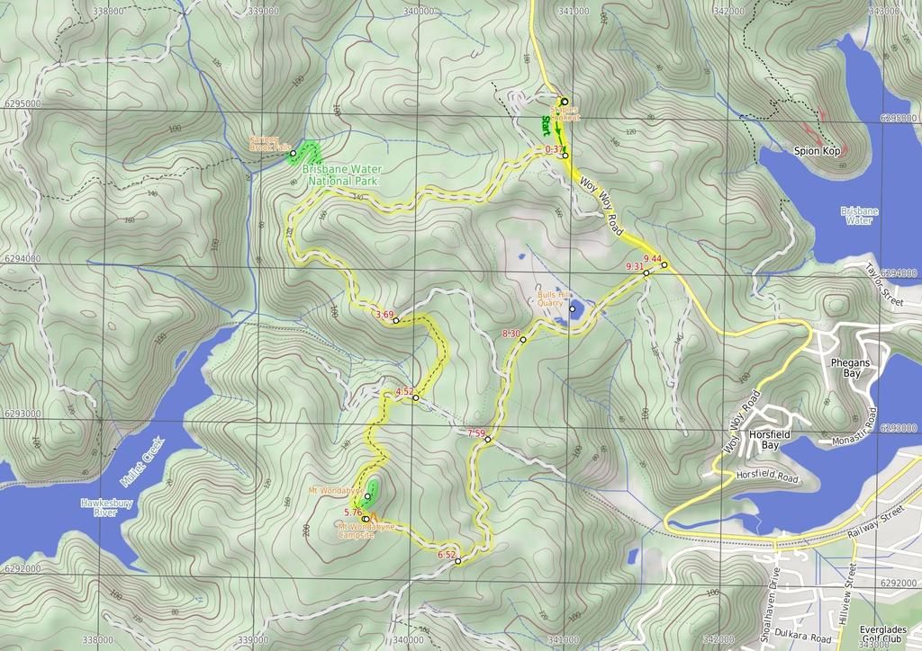
1 Staples Lookout to Mt Wondabyne loop 4 hrs 3 mins 1.8 km Circuit Hard track 337m This walk starts and finishes at Staples Lookout, on Woy Woy Rd. The walk follows sections of the Great North Walk around Mount Wondabyne and the old Bulls Hill Quarry. There are a few options for short side trips, one leading to the tranquil Kariong Brook falls and the other to the peak of Mount Wondabyne, providing great views over the National Park to Woy Woy. 4 Maps, text & images are copyright wildwalks.com Thanks to OSM, NASA and others for data used to generate some map layers. 15m Brisbane Water National Park 219m

2 Staples Lookout Staples Lookout beside Woy Woy Road, is a fenced lookout providing good views east across the Central Coast, the Brisbane Water and out to the ocean. There is a large car park and picnic tables, with plenty of natural shade. The lookout was named as a tribute to Charles J Staples, a pioneer of route that Woy Woy Rd now follows. The lookout was constructed in 1955 by the Rotary Club of Woy Woy. An inscription at the lookout quotes 'and I shall meditate on your wondrous works' from Psalm 119:27. Kariong Brook Falls This tranquil spot of the Great North Walk is home to some lovely falls and a water hole. The eastern side of the creek has a tall sandstone cave and wall. After rain these falls can become very spectacular, other times is a cool place to rest. A great spot to stop for a snack. Mt Wondabyne Mount Wondabyne is one of the most prominent peaks in Brisbane Water National Park. The long cone-shaped hill has a rocky top and is home to a trig station. Walkers can enjoy full 36-degree panoramic views from the top. To the east are good views over the Brisbane Water, Woy Woy and other central coast suburbs. West, down next to Mullet Creek, you can see some buildings near Wondabyne Station and the train line. Otherwise, most of the expansive views are over much of Brisbane Water National Park. There are some small trees providing limited shade, a great place to soak up the views. Mt Wondabyne Campsite This basic campsite is found at the end of a management trail, near the base of Mt Wondabyne. The campsite is at the bottom of a small (east facing) rock wall and has trees surrounding much of the area, providing some shelter. There is an established fire circle and a basic seat. There is no water or other facilities. (There is also small cave suitable for sleeping a few people about half way up Mount Wondabyne). Bulls Hill Quarry The Bulls Hill Quarry, which was once a sandstone quarry on the western side of Woy Woy Rd. In 22 Gosford Council proposed converting the quarry into a 'composting and recycling facility'. These plans where rejected due to concerns of the environmental impact. In 25 the then-department of Land and Water Conservation worked on the sediment dams to improve water flow quality from the site. Before You walk Bushwalking is fun and a wonderful way to enjoy our natural places. Sometimes things go bad, with a bit of planning you can increase your chance of having an ejoyable and safer walk. Before setting off on your walk check 1) Weather Forecast (BOM Hunter District) 2) Fire Dangers (Greater Sydney Region) 3) Park Alerts (Brisbane Water National Park) 4) Research the walk to check your party has the skills, fitness and equipment required 5) Agree to stay as a group and not leave anyone to walk solo Think before you TREK The 'Think before you TREK' program developed by NSW Police & NPWS promotes the benefits of planning ahead for your bushwalking trip by using an easy to remember acronym: T R E K Take adequate supplies of food, water, navigation and first aid equipment. Register your planned route and tell friends and family when you expect to return. Emergency beacon (PLB's) should be carried on walks with significant gaps in mobile coverage (check terrain profile). Keep to your planned route and follow the map and walking trails. Topo Maps The maps provided on wildwalks are helpful, but there are times where you may need maps covering a broader area. Maps that cover this walk include; 1:25 Map Series:91312S GOSFORD 1:1 Map Series:9131 GOSFORD Grade This walk has been graded using the AS The overall grade of the walk is dertermined by the highest classification along the whole track. 4 Length Time Quality of track Grade 4/6 Hard track 1.8 km Circuit 4 hrs 3 mins Rough track, where fallen trees and other obstacles are likely (4/6) Signs Directional signs along the way (3/6) Experience Required Weather Infrastructure Some bushwalking experience recommended (3/6) Weather generally has little impact on safety (1/6) Limited facilities, not all cliffs are fenced (3/6)
3 Are you ready to have fun? Please ensure you and your group are well prepared and equipped for all possible hazards and delays. Check park closures, weather information and Fire Danger Rating before setting out. Optional side trips and alternate routes noted are not included in this walks overall grade, length or time estimate. Please allow extra time for resting and exploring areas of interest. The authors, staff and owners of wildwalks take care in preparing this information but will not accept responsibility for any inconvenience, loss or injury you may experience. Please take care, have fun - Happy Walking. Getting there Traveling by car is the only practical way to get to Staples Lookout (gps: , ). Car: There is free parking available. This is a circuit, so you will finish back at the start. Find up to date and more information inlcuding; travel directions, weather, park closures and walker feedback at Staples Lookout Staples Lookout beside Woy Woy Road, is a fenced lookout providing good views east across the Central Coast, the Brisbane Water and out to the ocean. There is a large car park and picnic tables, with plenty of natural shade. The lookout was named as a tribute to Charles J Staples, a pioneer of route that Woy Woy Rd now follows. The lookout was constructed in 1955 by the Rotary Club of Woy Woy. An inscription at the lookout quotes 'and I shall meditate on your wondrous works' from Psalm 119:27. Staples Lookout (37 m 7 mins) From Staples Lookout, this walk heads downhill alongside Woy Woy Rd (keeping the view to the left). Where safe this walk crosses the road and continues down the hill. Just after passing a large brown 'Scenic Lookout 3m' sign (facing downhill), the walk comes to the signposted start of "Thommo's Loop Fire Trail" and a locked gate..37 Int of GNW and Woy Woy Road (1.8 km 37 mins) Turn right: From the intersection, this walk heads around the National Park gate and continues down the service trail for a short while, before coming to the intersection of the power line service trail. Continue straight: From the intersection, this walk follows the 'Thommas Loop' sign down the management trail as it bends left. The trail winds down the hill to soon cross a rock platform with good views. Continue straight: From the rock platform, this walk follows the management trail down the hill, keeping the valley views to the right. The trail then generally winds down the hill to come so a signposted three-way intersection with a 'Staples Lookout' sign pointing back up the hill. 2.2 Optional sidetrip to Kariong Brook crossing (69 m 24 mins) Turn right: From the intersection, this walk follows the 'Girrakool' sign gently down along the narrower track. The track leads down for about 6m to pass over a rock outcrop and then 8m later, comes to a clearing that has been used as a campsite (on your left). From the clearing, the track continues down the hill for about 15m, stepping down the rocks and along a sandy track to then bend right at metal handrail. Here the rocky track becomes quite steep in places and winds down past some rock walls and among the grass trees for about 3m, where the track bends sharp right at the bottom of some steps in a cleft in the rock. The track continues down for another 1m to follow the steps down through the sandstone overhang, here the track bends left then right to wind down and cross the creek (that is often underground) and come to an intersection with a faint track in front of Kariong Brook Falls (on your right). At the end of this side trip, retrace your steps back to the main walk then Veer right. 2.2 Kariong Brook Falls This tranquil spot of the Great North Walk is home to some lovely falls and a water hole. The eastern side of the creek has a tall sandstone cave and wall. After rain these falls can become very spectacular, other times is a cool place to rest. A great spot to stop for a snack. 2.2 Int of the GNW and Patonga service trail (1.5 km 28 mins) Veer left: From the intersection, this walk follows the GNW arrow post and 'Patonga' sign downhill along the management trail. The trail then winds along the side of the hill for about 1.3km (passing a pleasant grove of large Sydney Redgums) to then step up onto a particularly large rock platform. After crossing this rock platform, the trail continues for another 12m to come to a Y-intersection (at another rock platform) where a 'Girrakool' sign points back along the track Int of GNW and Thommos Loop trail (83 m 18 mins) Veer right: From the intersection, this walk follows the GNW arrow post and 'Patonga' sign east, gently downhill along the narrow track. After about 25m, the track leads to a notably large rock platform with a clear view across the valley to Mt Wondabyne. Here the track continues gently downhill, crossing more rock platforms for about 3m to head over a section of timber boardwalk and past a few disused power poles. The track then continues over another rock platform for another 2m to cross a small ephemeral creek. From the creek, the track leads up a short distance up under the power lines to come to a T-intersection with a wide trail, where a sign points back to 'Girrakool' Int of GNW and Mullet Creek Trail (east) (1.2 km 25 mins) Turn right: From the intersection, the track follows the GNW arrow post along the management trail, initially keeping the power lines to your right. The trail soon bends left and leads uphill. As the trail flattens out again, it comes to a three-way intersection marked with a 'Great North Walk' and 'Wondabyne Station' sign, pointing back along the trail. Turn left: From the intersection, this walk follows the 'Mt Wondabyne' sign south up the trail. The trail soon begins to narrow and after almost 2m, the track steps up to cross a rock platform, following a few GNW arrow posts to find a GNW 'Walker Register' tube. After writing a comment, the walk continues uphill along the track for about 7m, as the track become progressively flatter, passing beside the Mt Wondabyne Peak (up to your left). Then about 5m after leaving the trees and entering a section of low heath, this track then comes to a three-way intersection (the Mt Wondabyne peak track, on the left), marked with a GNW arrow post Optional sidetrip to Mt Wondabyne Peak (21 m 5 mins) Turn left: From the intersection, this walk follows the Mt Wondabyne peak track north-east as it heads uphill directly towards Mt Wondabyne. The track is leads gently at first then starts to climb up a series of rock ledges. After about 6m, the track passes a small cave (large enough for 2 or 3 people to lie in). The track then continues to climb for another 9m, up the rocky track then for through a grove of small trees, to come to the first peak. The faint track continues along the ridge for another 6m then comes to the main peak, where there is an old trig station and great panoramic views. At the end of this side trip, retrace your steps back to the main walk then Turn left Mt Wondabyne Mount Wondabyne is one of the most prominent peaks in Brisbane Water National Park. The long cone-shaped hill has a rocky top and is home to a trig station. Walkers can enjoy full 36-degree panoramic views from the top. To the east are good views over the Brisbane Water, Woy Woy and other central coast suburbs. West, down next to Mullet Creek, you can see some buildings near Wondabyne Station and the train line. Otherwise, most of the expansive views are over much of Brisbane Water National Park. There are some small trees providing limited shade, a great place to soak up the views Int of GNW and Mt Wondabyne Peak tracks (9 m 2 mins) Continue straight: From the intersection, this walk follows the GNW arrow post south over a small rise then gently downhill along the rocky track, leaving Mt Wondabyne peak behind and to your left. After about 9m, the track leads down to a clearing at the end of a management trail, where there is a sign pointing back to 'Mooney Mooney rest area'. This is the Mt Wondabyne campsite Mt Wondabyne Campsite This basic campsite is found at the end of a management trail, near the base of Mt Wondabyne. The campsite is at the bottom of a small (east facing) rock wall and has trees surrounding much of the area, providing some shelter. There is an established fire circle and a basic seat. There is no water or other facilities. (There is also small cave suitable for sleeping a few people about half way up Mount Wondabyne) Mt Wondabyne Campsite (76 m 16 mins) Turn left: From the clearing (campsite), this walk follows the 'Patonga' sign down the wide management trail. The trail winds downhill for about 3m, enjoying some views back to Mount Wondabyne as well as to Woy Woy and Brisbane Water. From here, the trail continues downhill through the heath for another 4m to come to a T-intersection with another management trail (Tunnel Track), where there is a 'Mt Wondabyne' and 'Girrakool' sign pointing back up the hill Int of Girrakool and Mt Wondabyne tracks (1.1 km 22 mins) Turn left: From the intersection, this walk follows the management trail down the hill as it bends to the left (initially keeping Mt Wondabyne to the left). The trail winds down the hill, passing a filtered view of the Woy Woy landfill site and some nice sandstone formations. The trail then leads into a valley and crosses an often dry creek using a concrete ford. Soon after this, the trail comes to a four-way intersection, with some power lines and a sign pointing back to 'Tunnel Track' Int of Tunnel and Mullet Creek Tracks (72 m 13 mins) Continue straight: From the intersection, this walk heads north-east along the management trail up the hill, away from the power lines (not following any of the signs). The trail soon comes to a three-way intersection with the signposted 'Thommos Loop' trail (on the left). Continue straight: From the intersection, this walk follows the red-gravelly trail north, gently downhill (soon bending right). The trail passes an old rusty trailer (on the left) and soon comes to a 'Brisbane Water National Park' sign and heads around a locked gate. 8.3 Brisbane Waters NP gate (1 km 18 mins) Continue straight: From the gate, this walk heads away from the gate and national park along the management trail. The trail soon comes to the old Bulls Hill Quarry (on the left) and continues around the edge, passing the pondage area (there are many tracks in the are, this walk follows the main Tunnel Track). The trail bends left, rounding the quarry to cross the sandstone rock platform and climb the gravelly trail leaving the quarry behind. About 17m after passing under the power lines, the trail comes to an intersection with a power line maintenance trail (on the right, signposted '83') Bulls Hill Quarry The Bulls Hill Quarry, which was once a sandstone quarry on the western side of Woy Woy Rd. In 22 Gosford Council proposed converting the quarry into a 'composting and recycling facility'. These plans where rejected
 Continue straight: From the intersection, this walk heads towards the gate (and road), just visible up the gentle hill along the")
4 due to concerns of the environmental impact. In 25 the then-department of Land and Water Conservation worked on the sediment dams to improve water flow quality from the site Int of Tunnel track and Powerline maintenance trai (13 m 2 mins) Continue straight: From the intersection, this walk heads towards the gate (and road), just visible up the gentle hill along the management trail. On the other side of the gate, the walk comes to small clearing beside Woy Woy Rd (a short distance uphill from the speed camera) Int of Tunnel track and Woy Woy Rd (1.4 km 27 mins) Turn left : From the small clearing, this walk follows alongside Woy Woy Rd away from the speed camera, passing the large 'Overtaking lane 4m Ahead' sign up the hill. Soon the road leads to a 'Roy Lamb the Sand Man' sign. Continue straight: From the 'Roy Lamb the Sand Man' sign, this walk follows beside Woy Woy Rd, heading up the hill (passing a house on the left). The road sweeps left and (about 1m past the yellow 'Left Lane Ends' sign) the walk comes to an intersection with a power line access trail (on the left). Continue straight: From the intersection, this walk heads up the hill beside Woy Woy Rd (away from the water view), soon coming to an intersection with the signposted start of the 'Thommo's Loop Fire Trail' and gate (on the left) - just before the brown 'Scenic Lookout' sign. Continue straight: From the intersection, heads along Woy Woy Road passing the large brown 'Scenic Lookout 3m' sign. The walk crosses the road (where safe) and crosses a grassy area to come to the car park and signposted Staples Lookout.
5
6 Powered by TCPDF ( Summary navigation sheet for the Staples Lookout to Mt Wondabyne loop km From Up/Dwn Length Initial directions (Use full tracknotes and maps for more detail) Start Staples Lookout , (GR Gosford, 49951) m 7 mins From Staples Lookout, this walk heads downhill alongside Woy Woy Rd (keeping the view to the left)..37 Int of Great North Walk and Woy Woy Road , (GR Gosford, 41948) km 37 mins Turn right: From the intersection, this walk heads around the National Park gate and continues down the service trail for a short while, before coming to the intersection of the power line service trail. 2.2 Int of the Great North Walk and Patonga service trail , (GR Gosford, ) m 24 mins Optional sidetrip to Kariong Brook crossing. Turn right: From the intersection, this walk follows the 'Girrakool' sign gently down along the narrower track. 2.2 Int of the Great North Walk and Patonga service trail , (GR Gosford, ) km 28 mins Veer left: From the intersection, this walk follows the GNW arrow post and 'Patonga' sign downhill along the management trail Int of GNW and Thommos Loop trail , (GR Gosford, ) m 18 mins Veer right: From the intersection, this walk follows the GNW arrow post and 'Patonga' sign east, gently downhill along the narrow track Int of GNW and Mullet Creek Trail (east) , (GR Gosford, 4932) km 25 mins Turn right: From the intersection, the track follows the GNW arrow post along the management trail, initially keeping the power lines to your right Int of Great North Walk and Mt Wondabyne Peak tracks , (GR Gosford, ) m 5 mins Optional sidetrip to Mt Wondabyne Peak. Turn left: From the intersection, this walk follows the Mt Wondabyne peak track north-east as it heads uphill directly towards Mt Wondabyne Int of Great North Walk and Mt Wondabyne Peak tracks , (GR Gosford, ) -6 9 m 2 mins Continue straight: From the intersection, this walk follows the GNW arrow post south over a small rise then gently downhill along the rocky track, leaving Mt Wondabyne peak behind and to your left Mt Wondabyne Campsite , (GR Gosford, ) m 16 mins Turn left: From the clearing (campsite), this walk follows the 'Patonga' sign down the wide management trail Int of Girrakool and Mt Wondabyne tracks , (GR Gosford, 43921) km 22 mins Turn left: From the intersection, this walk follows the management trail down the hill as it bends to the left (initially keeping Mt Wondabyne to the left) Int of Tunnel and Mullet Creek Tracks , (GR Gosford, 45929) m 13 mins Continue straight: From the intersection, this walk heads north-east along the management trail up the hill, away from the power lines (not following any of the signs). 8.3 Brisbane Waters NP gate , (GR Gosford, 47936) km 18 mins Continue straight: From the gate, this walk heads away from the gate and national park along the management trail Int of Tunnel track and Powerline maintenance trail , (GR Gosford, 41594) 4 13 m 2 mins Continue straight: From the intersection, this walk heads towards the gate (and road), just visible up the gentle hill along the management trail Int of Tunnel track and Woy Woy Rd , (GR Gosford, ) km 27 mins Turn left : From the small clearing, this walk follows alongside Woy Woy Rd away from the speed camera, passing the large 'Overtaking lane 4m Ahead' sign up the hill.
Girrakool to Wondabyne station
 Girrakool to Wondabyne station 4 hrs Hard track 9.5 km One way 4 438m This walk starts from the Girrakool picnic area and winds south, through the Brisbane Waters National Park. The walk crosses some long
Patonga to Staples Lookout
 Patonga to Staples Lookout 6 hrs 3 mins 17 km One way Hard track 4 72m This great walk explores much of the main ridge ridge running through Brisbane Water National Park. The walk visits a number of great
Congewai Track Head (East) to Watagan Headquarters
 to Watagan Headquarters") Congewai Track Head (East) to Watagan Headquarters 7 hrs Hard track 17.2 km One way 4 973m This full day walk starts from the Congewai valley trackhead (east) and follows the Great North Walk up into the
Congewai Track Head (East) to Watagan Headquarters 7 hrs Hard track 17.2 km One way 4 973m This full day walk starts from the Congewai valley trackhead (east) and follows the Great North Walk up into the
Nature Track. 900m. 789m. 2 hrs 3.1 km Circuit. Hard track 238m. Blue Mountains National Park
 Nature Track 2 hrs 3.1 km Circuit Hard track 238m Largely following the ridges around the top edge of Wentworth Falls, this track is incredibly beautiful. After taking in the great views at Edinburgh Castle
Leura Cascades to Gordon Falls Reserve
 Leura Cascades to Gordon Falls Reserve 1 hr 15 mins 1.8 km One way Moderate track 200m From Leura Park to Gordon Falls Park, this diverse walk offers fantastic views of the Jamison Valley, as well as two
Erskine Creek via Pisgah Rock and Jack Evans
 Erskine Creek via Pisgah Rock and Jack Evans 4 hrs 30 mins 7.1 km Circuit Very experienced only 6 421m This walk visits some great lookouts and explores the lower section of Erskine Creek. Most of the
Mt Kuring-gai Track to Berowra station
 Mt Kuring-gai Track to Berowra station 4 hrs 15 mins 9.7 km One way Hard track 4 553m This walk explores three valleys, with great displays of wild flowers in spring, and some nice sandstone overhangs.
Patonga to Wondabyne station via Mt Wondabyne
 Patonga to Wondabyne station via Mt Wondabyne 7 hrs 3 mins 19.5 km One way Hard track 4 861m This walk explores some grand views, pleasant cascades, varied bushland and remote areas of Brisbane Waters
Abbotts Falls Walking Track
 Abbotts Falls Walking Track 3 hrs 7.3 km Circuit Hard track 329m This circuit takes you through both dry and moist forest, using a combination of walking trails and wider tracks. The side trip to the dammed
Girrakool to Wondabyne station via Pindar caves
 Girrakool to Wondabyne station via Pindar caves 7 hrs 30 mins 18.1 km One way Experienced only 5 741m This walk starts from the Girrakool picnic area and winds south, following Piles creek into the Brisbane
Victoria Falls Lookout to Blue Gum Forest
 Victoria Falls Lookout to Blue Gum Forest 8 hrs Experienced only 13.8 km One way 5 112m This long day-walk follows a remote track down from Victoria Falls lookout, passing the waterfall, and into the Grose
Merritts Traverse. 1928m
 Merritts Traverse 3 hrs Hard track 5.8 km Circuit 4 167m This walk starts with a scenic journey to the top of the hill on the chairlift. Starting along Merritts Nature walk, this walk soon detours down
Berowra Waters to Cowan Station
 Berowra Waters to Cowan Station 3 hrs 30 mins 7.2 km One way Hard track 597m This is a hilly walk out of the beautiful Berowra Waters valley to Cowan Station. There are many wide views across Berowra Creek
Patonga to Wondabyne station via Pindar Caves overnight
 Patonga to Wondabyne station via Pindar Caves overnight 2 Days Experienced only 28.1 km One way 5 1164m This overnight hike starts from Patonga beach and winds along a section of the Great North Walk,
Guthega to Mt Twynam. 2183m. 1583m. 6 hrs 45 mins 14.8 km Return. Experienced only. 913m
 Guthega to Mt Twynam 6 hrs 45 mins 14.8 km Return Experienced only 5 913m This walk starts from Guthega and makes its way along the Snowy River to the Illawong Lodge, via the Blue Cow Creek flying fox.
National Pass. 893m. 665m. 3 hrs 30 mins 4.6 km Circuit. Hard track 773m. Blue Mountains National Park
 National Pass 3 hrs 3 mins 4.6 km Circuit Hard track 773m 4 This walk offers fantastic views of the Jamison Valley and the surrounding cliffs. Take time to explore the historic and very scenic ledge halfway
Dadder Cave and Jack Evans track
 Dadder Cave and Jack Evans track 2 Days 10.3 km Circuit Very experienced only 535m This fairly short overnight walk is a great way to explore Erskine Creek. The walking along Erskine creek is mostly off
Wentworth Pass. 893m. 535m. 4 hrs. Hard track 5.1 km Circuit. 692m
 Wentworth Pass 4 hrs Hard track 5.1 km Circuit 4 692m This walk offers a great way to explore the magical, upper section of the Valley of the Waters. The walk starts and finishes at Conservation Hut, which
Cowan to Wondabyne station via Patonga rest area
 Cowan to Wondabyne station via Patonga rest area 2 Days Hard track 33.4 km One way 4 1523m This section of the Great North Walk starts from Cowan train station and wanders past the majestic Jerusalem Bay
Berowra to Cowan via Berowra Waters
 Berowra to Cowan via Berowra Waters 6 hrs Hard track 12.9 km One way 4 884m With train station at each end this walk explores the ridges and valleys around Berowra Waters. There are plenty of excellent
Jerusalem Bay Track (Cowan to Brooklyn)
") Jerusalem Bay Track (Cowan to Brooklyn) 5 hrs 30 mins 13.4 km One way Hard track 4 654m This Cowan to Brooklyn Station walk is a popular section of the Great North Walk, with scenery ranging from foreshore
Jerusalem Bay Track (Cowan to Brooklyn) 5 hrs 30 mins 13.4 km One way Hard track 4 654m This Cowan to Brooklyn Station walk is a popular section of the Great North Walk, with scenery ranging from foreshore
Scenic Railway to Ruined Castle
 Scenic Railway to Ruined Castle 7 hrs 30 mins 12.4 km Return Hard track 4 963m This is a very popular, full day walk, in the Katoomba Area, offering great views of the valley. The walk follows the edge
Crosslands to Berowra Waters return
 Crosslands to Berowra Waters return 6 hrs Hard track 13.7 km Return 4 1005m This return walk starts from the Crosslands Reserve and follows the Great North Walk along Berowra creek. The walk includes some
Crosslands to Cowan. 220m
 Crosslands to Cowan 7 hrs 30 mins 14 km One way Hard track 4 1103m This section of the Great North Walk starts from the Crosslands camping area and winds north alongside Berowra creek, passing through
Wondabyne station to Somersby Store
 Wondabyne station to Somersby Store 10 hrs Hard track 26.2 km One way 4 1164m This walk, following a section of the Great North Walk, starts from the Wondabyne train station and winds north, into the Brisbane
Lady Carrington Drive
 Lady Carrington Drive 3 hrs 45 mins 9.7 km One way Moderate track 3 266m This walk follows the historic Lady Carrington Drive alongside the Hacking River. The old road is closed to traffic and provides
Victoria Falls to Blackheath Station
 Victoria Falls to Blackheath Station 2 Days Experienced only 22.2 km One way 5 1561m This is a fantastic overnight walk with a sleep in Acacia Flats camping area. The Grose Valley, with its views of the
Main Range Walk - Charlotte Pass to Mount Kosciuszko
 Main Range Walk - Charlotte Pass to Mount Kosciuszko 9 hrs Hard track 21.9 km Circuit 4 920m This full day walk explores some of the greatest alpine country on offer in NSW. The walk grants views of Blue,
Gibberagong Track. 169m
 Gibberagong Track 2 hrs 30 mins 6.5 km One way Hard track 4 180m Starting in suburban Wahroonga, this wellmaintained track follows Cockle Creek down to Bobbin Head in the Ku-ring-gai Chase National Park.
Main Range Track - Loop from Charlotte Pass camping near Mt Townsend
 Main Range Track - Loop from Charlotte Pass camping near Mt Townsend 2 Days Experienced only 27.7 km Circuit 5 1260m This great overnight walk starts from Charlotte Pass and provides access to some of
Victoria Falls and Grose Valley to Blackheath Station
 Victoria Falls and Grose Valley to Blackheath Station 3 Days Experienced only 22.5 km One way 5 158m This walk explores a fantastic section of the Grose Valley. Starting above Victoria Falls, the walk
Hornsby station to Crosslands
 Hornsby station to Crosslands 6 hrs 45 mins 16.1 km One way Hard track 4 938m This section of the Great North Walk starts from Hornsby train station and winds down along the Blue Gum Walk into Fishponds.
Leura to Katoomba via Dardanelles Pass
 Leura to Katoomba via Dardanelles Pass 4 hrs 6.6 km One way Hard track 697m With approximately equal parts cliff-walk and forest track, this track truly shows what the cliff edges of the Jamison Valley
Somersby to Yarramalong via Stringy Bark Point
 Somersby to Yarramalong via Stringy Bark Point 2 Days Hard track 26.7 km One way 4 1201m This section of the Great North Walk starts form the Somersby General Store and follows the Great North Walk north
Blackheath to Blue Gum loop
 Blackheath to Blue Gum loop 2 Days Hard track 24.1 km Circuit 4 1335m This walk is great for fit people getting into overnight walking, with its fantastic scenery and nostalgia as a classic overnighter.
Berowra to Hornsby. 9 hrs 18 mins 22.6 km One way. Hard track. 1423m
 Berowra to Hornsby 9 hrs 18 mins 22.6 km One way Hard track 4 1423m One of the longer day walks in Berowra Valley National Park, this walk mostly follows Berowra Creek along the Great North Walk. Excellent
Guthega to Thredbo camping overnight at Wilkensons Creek
 Guthega to Thredbo camping overnight at Wilkensons Creek 2 Days Experienced only 25.8 km One way 5 1364m This great overnight walk explores the Kosciusko National Park between Guthega and Thredbo, visiting
The Prince Henry Cliff Walk
 The Prince Henry Cliff Walk 3 hrs 30 mins 6.8 km One way Moderate track 3 575m Going from Katoomba to Leura, this walk covers the top of the cliff line and most of the major lookouts. With brilliant vistas
Somersby to the Basin Campsite
 Somersby to the Basin Campsite 3 Days Hard track 47.4 km One way 4 2032m This three day walk starts at the Somersby General Store and follows the Great North Walk, heading north, into the the Jilliby State
Crosslands to Brooklyn
 Crosslands to Brooklyn 2 Days Hard track 27.4 km One way 4 1757m From the Crosslands Reserve, this walk heads along the Great North Walk via Berowra Waters, Cowan, Jerusalem Bay and onto Brooklyn. This
Main Range Circuit from Guthega
 Main Range Circuit from Guthega 4 Days Experienced only 45 km Circuit 5 2317m This four day walk explores the Kosciuszko National Park, covering many of the key features of the park between Guthega and
Katoomba to Wentworth Falls via the Jamison Valley
 Katoomba to Wentworth Falls via the Jamison Valley 2 Days Experienced only 29.2 km One way 5 2135m This is the two day version of this popular and challenging walk. This walk passes popular sights including
Gordon to Hornsby (overnight at Scout camp)
") Gordon to Hornsby (overnight at Scout camp) 2 Days Hard track 25.8 km One way 4 125m This overnight walk starts from Gordon train station and winds through bush filled valleys to Hornsby station. From
Gordon to Hornsby (overnight at Scout camp) 2 Days Hard track 25.8 km One way 4 125m This overnight walk starts from Gordon train station and winds through bush filled valleys to Hornsby station. From
Western Commission Track to Dubbo Gully
 This two day walk follows a series of historic roads along clear and wide management trails. This walk explores the great views from Western Commission Track, the sandstone handicraft on the Old Great
Victoria Falls and Grose Valley to Blackheath Station
 This walk explores a fantastic section of the Grose Valley. Starting above Victoria Falls, the walk explores the cascades before dropping into the valley for the first nights rest at Burra Korain campsite.
Printed in China by Designed by Coral Lee Main cover image: Broken Bay
 Woodslane Press Pty Ltd Unit 7/5 Vuko Place Warriewood, NSW 2102 Australia Email: info@woodslane.com.au Tel: (02) 9970 5111 Fax: (02) 9970 5002 http://travelandoutdoor.bookcentre.com.au First published
Thornleigh to Cowan. 2 Days. Hard track 35.9 km One way. 2337m
 Thornleigh to Cowan 2 Days Hard track 35.9 km One way 4 2337m Following the Great North Walk and Berowra Creek through Berowra Valley Regional Park, this walk cuts straight through the length of the Park.
COLOUR G U I D E. Sydney to Newcastle: Australia s most accessible long-distance walk
 COLOUR G U I D E Sydney to Newcastle: Australia s most accessible long-distance walk Woodslane Press Pty Ltd Unit 7/5 Vuko Place Warriewood, NSW 2102 Australia Email: info@woodslane.com.au Tel: (02)
Out and about at Geehi
 Geehi Geehi Flats is a large area of flat floodplain on the banks of the Swampy Plains River. Located within Kosciuszko National Park, it is home to a popular campsite in summer for people wanting to enjoy
Hindhead, Keffolds Copse and Gibbet Hill
 point your feet on a new path, Keffolds Copse and Gibbet Hill Distance: 6 km=4 miles Region: Surrey Author: Schwebefuss Refreshments: Punch Bowl Café moderate walking Date written: 14-apr-2015 Last update:
Leaden Boot Challenge ROUTE INSTRUCTIONS
 Leaden Boot Challenge ROUTE INSTRUCTIONS Section 1 Alstonefield to Ilam From the village hall car park turn R then L and pass through the village keeping to the R to enter Church Street. Pass the Church
1. Waterfall Gully Mt Lofty. 5 Of the Best Hikes in Adelaide
 Adelaide is a beautiful city, and one of the most incredible things about Adelaide is the quality of bushwalking available on the suburban fringe. It is surrounded by the Mt Lofty Ranges, and much of the
The Mendip Way. Route Directions and Maps Uphill to Wells
 The Mendip Way Route Directions and Maps Uphill to Wells Website: www.mendiphillsaonb.org.uk Email: mendip@mendiphillsaonb.org.uk Facebook & Twitter: @MendipHillsAONB Phone: 01761462338 1 Uphill to Loxton
Leaden Boot Challenge 2016 ROUTE INSTRUCTIONS
 Leaden Boot Challenge 2016 ROUTE INSTRUCTIONS Section 1 Alstonefield to Ilam (CP2) From the village hall car park turn R then L and pass through the village keeping to the R to enter Church Street. Pass
beach. Make the ford and follow the trail out to the junction with Red Creek Tr in an open grassy area.
 Description: This is a moderate to slightly strenuous 22.8 mile backpack (add 2.6 miles if you do the packless out and back to the Lion s Head) that will have you exploring nearly every thing that is The
Trail Phasing Plan. Note: Trails in the Clear Creek Canyon area (Segments will be finalized in the future to minimize wildlife impacts
 Note: Trails in the Clear Creek Canyon area (Segments 2 5 and a future JCOS connection) will be finalized in the future to minimize wildlife impacts Trail Phasing Plan P Parking 3 Easy Trail Intermediate
CWMGIEDD FROM ABERCRAVE
 Abercrave to Cwmgiedd Walk Page 1 Starting from The Abercrave Inn. Grid Ref: SN 824128 From the Abercrave Inn, an 11.3km (7 miles) walk to the foothills of the Cribarth Mountain, then through forest to
Beautiful Walks from the Blue Ball Inn
 Walk No. 5 RIVER VALLEYS AND MOOR Countisbury, Watersmeet, Hillsford Bridge, Cheriton, Shilstone Hill, Rockford and Chiselcombe. 8.5 MILES APPROX. Walking time four and a half hours approx. OS 1;25,000
GOLDEN EARS PROVINCIAL PARK
 GOLDEN EARS PROVINCIAL PARK Trail Information as of October 10 th 2015 Do not underestimate the mountainous wilderness of Golden Ears Provincial Park. The combination of rugged terrain and rapidly changing
ID: 283 Distance: 6.2 miles Height gain: 500 Metres Map: Explore OL 19 Contributor David and Chris Stewart
 Walkingworld Wild Boar Fell ID: 283 Distance: 6.2 miles Height gain: 500 Metres Map: Explore OL 19 Contributor David and Chris Stewart Features Birds, Great Views, Hills or Fells Description: Wild Boar
Below is an example of a well laid-out template of a route card used by the Sionnach Team which is a good format to begin with.
 Route Card A route card is used as a navigational aid to hill walkers by setting out a step by step plan for an intended hike. It is good practice to make out a route card before every hike you or your
Sponsored by. statestreet.com
 /STATESTREETISLANDWALK #ISLANDWALKJSY Sponsored by statestreet.com Important Information If you forget everything else PLEASE remember the following.» Remember to check OUT of every checkpoint» If you
Slad over to Pitchcombe and back
 The walk climbs up from Slad over Wickridge Hill, descends to near Pitchcombe, then climbs back over Wickridge hill and round the back of Slad. Page 1 Start Point: SO 8718 0732 The Woolpack, Slad Length:
middle left: Riversleigh fossils lower left: Constance Range images: Hj Preuss... Thx
 Upstreampaddle Summer 2008 18 middle left: Riversleigh fossils lower left: Constance Range images: Hj Preuss... Thx top right: road west of the Isa middle right: Constance Range lower right: rocky outcrop
Skiing and Snowshoes on Un-groomed Fernan Saddle Terrain
 Skiing and Snowshoes on Un-groomed Fernan Saddle Terrain Three ski or snowshoe routes are available from the Fernan Saddle Parking Lot which either do not cover routes ordinarily groomed for snow machine
TREK THE ROCKIES ABOUT THE CHALLENGE TREK THE ROCKIES FOR HIGHLAND HOSPICE CANADA TREK DEMANDING
 TREK THE ROCKIES CANADA TREK DEMANDING ABOUT THE CHALLENGE The Canadian Rockies are justifiably world-famous for their magnificent scenery: the combination of impressive, jagged mountains, bright turquoise
Bewl Water & the High Weald
 1 Bewl Water & the High Weald Stonegate station - Stonegate - Wallcrouch - Newbarn - Cousley Wood - Wood's Green - Wadhurst station Length: 9 ½ miles (15.3km) Underfoot: Large portions of this path are
Arches of the. Sandflats Area. By Virginia Allen
 Arches of the Sandflats Area By Virginia Allen TABLE OF CONTENTS Introduction Dedication Road Log Arches 1. Perforated View Arch 2. Fee Booth Arch 3. Windsong Arch 4. Weird Arch 5. Resting Arch 6. Bike
This path goes past an old tree nursery and sawmill. After 800m it crosses over a lane. Follow the bridleway fingerpost into the woods.
 FRENSHAM PONDS 11K CIRCULAR TRAIL 2½ HRS GU10 2DA This magnificent heathland trail starts in woodland and then brings you out onto the open heather of Frensham Common, with no roadwork! The route runs
Little Grand Canyon near Pomona, Illinois
 Little Grand Canyon near Pomona, Illinois Below: View of the trail and the terrain created using the Map My Hike app Below: Summary of the hike created using the Map My Hike app Presented by: Jennifer
YOSEMITE TO SAN FRANCISCO CYCLE
 USA CYCLE DEMANDING ABOUT THE CHALLENGE Journey from the spectacular Yosemite National Park to the Pacific Coast, finishing with an unforgettable finish at the iconic Golden Gate Bridge into San Francisco.
C E N T R A L C A T S K I L L S
 120 C E N T R A L C A T S K I L L S Central Catskills Once out of the southern parts of the Catskills, the Long Path enters the more well traveled and civilized regions. The trail joins the Devil s Path,
Britain s oldest surviving water-balanced cliff lift
 44 3.6 Saltburn by the Sea to Sandsend Map panels 3 and 4 Distance 17 miles (27½ km) Terrain mostly grass and field paths which can be muddy; some pavement, beach and shore Grade undulating route, with
Hiking Las Vegas.com
 Hike: Mt. Wilson via First Creek Canyon route Trailhead: First Creek marked Distance: 10 miles up and back Elevation gain: 3,400 feet Elevation of Peak: 7,070 feet Time: 7 to 9 hours (up and back) Difficulty:
INTERMEDIATE. mayorsmtbchallenge.org
 mayorsmtbchallenge.org Redding s second local Mountain Bike Challenge uniting current and new bicyclists in a friendly self-competition highlighting our diverse trail system. INTERMEDIATE Mule Ridge Cosmos
Wicklow Mountains Path Survey
 Wicklow Mountains Path Survey Ballinacor Croaghanmoira Fananierin Start to Finish: T 11723 86602 to T 11175 89057 Altitude (lowest highest): 385m 664m Weather: Hot Access: Coolgarrow forest entrance Surveyed
Asheville & WNC Hikes
 Asheville & WNC Hikes Amazingly, we have 3,000+ miles of free public hiking trails near Asheville, including 1,600 miles in the Pisgah and Nantahala National Forests, 850 miles in Great Smokey Mountains
Ystwyth and Rheidol Bridleway Routes. Route 2:Llanilar Circular
 Ystwyth and Rheidol Bridleway Routes Route 2:Llanilar Circular Route overview and terrain: A long circle using connecting ridges with fine views to link the Rheidol and Ystwyth river valleys. The route
Tiger Mountain State Forest:
 98 60 hikes within 60 miles: SEATTLE 20 Tiger Mountain State Forest: West Tiger Mountain Three Loop i KEY AT-A-GLANCE INFORMATION Length: 5.1 miles round-trip Configuration: Loop Difficulty: Moderate difficult
Prince Regent National Park
 Prince Regent National Park 23 rd June- 14 th July 2019 Garimbu Creek, Moran and Roe River Area Notes written by Cassie Newnes This area has something for everyone, magnificent scenery, stunning waterfalls,
Central Coast Hunter Range Region Discovery Program
 Central Coast Hunter Range Region Discovery Program Sydney to Newcastle General Inquiries NPWS (02) 4320 4200 (Monday - Friday) Detailed Information Anne Whyte, Discovery Coordinator NPWS (02) 4320 4205
Self-Guided Walk Langdale Pikes. Start & Finish: NT car park (free to members) at Sticklebarn - on the right just beyond the New Dungeon Ghyll hotel.
 at Sticklebarn - on the right just beyond the New Dungeon Ghyll hotel.") Self-Guided Walk Langdale Pikes Key Information These mountains form a collection of spires and cliffs on the north side of Langdale. This walk visits four of the main tops Pavey Ark, Harrison Stickle,
Self-Guided Walk Langdale Pikes Key Information These mountains form a collection of spires and cliffs on the north side of Langdale. This walk visits four of the main tops Pavey Ark, Harrison Stickle,
A Circular Walk from Chapel Carn Brea
 A Circular Walk from Chapel Carn Brea 4.3 Miles A Walk Visiting Five Historic Ancient Sites This circular walk offers the possibility of several alternatives, depending on the walker s available time and
Rogue Gorge (Mt. Stella) Roadless Area-- T30S R3E (primarily in portions of Sections 23, 26, 33, 34 & 35)
 Roadless Area-- T30S R3E (primarily in portions of Sections 23, 26, 33, 34 & 35)") Rogue Gorge (Mt. Stella) Roadless Area-- T30S R3E (primarily in portions of Sections 23, 26, 33, 34 & 35) Rogue River-Siskiyou National Forest--High Cascades Ranger District Upper, higher elevation trail
Rogue Gorge (Mt. Stella) Roadless Area-- T30S R3E (primarily in portions of Sections 23, 26, 33, 34 & 35) Rogue River-Siskiyou National Forest--High Cascades Ranger District Upper, higher elevation trail
Illawarra Escarpment State Conservation Area Walking Tracks
 Illawarra Escarpment State Conservation Area Walking Tracks NPWS Illawarra Area Office Ground Floor, Government Office Block 84 Crown Street Wollongong NSW 2500 02 4223 3000 (Mon-Fri) Royal National Park
Hiking Las Vegas.com
 Hike: Juniper Peak up and back Trailhead: Oak Creek Canyon marked Distance: 5.5 miles round trip Elevation gain: 2,200 feet Elevation peak: 6,109 feet Time: 4 to 5 hours - Up and back Difficulty: 3 Danger
Ardingly Lake, Ouse Valley, Borde Hill
 point your feet on a new path Ardingly Lake, Ouse Valley, Borde Hill Distance: 14 km=9 miles or 12½ km=8 miles Region: West Sussex Author: Hautboy Refreshments: Borde Hill Map: Explorer 135 (Ashdown Forest)
Charnley Explorer June 24 - July 15, 2018 Bachsten Creek and the Charnley River. Second draft: 14 November 2017
 Charnley Explorer June 24 - July 15, 2018 Bachsten Creek and the Charnley River. Second draft: 14 November 2017 The best part of the original section one is now part of out Gibb Road Gorges trip. The dates
BURGHCLERE PARISH RIGHTS OF WAY
 BURGHCLERE PARISH RIGHTS OF WAY Full descriptions compiled by Neill & Miggie Bruce All photos Miggie Bruce FP23 on Ridgemoor, looking south, with FP22 crossing by the bush FP1. From C183 Aldern Bridge
Darwin s gigantic blunder
 Trail Darwin s gigantic blunder Explore how ice shaped the landscape and why Charles Darwin made a nice mess of Glen Roy Time: 1hr 10 mins Distance: 2 miles Landscape: rural At Glen Roy a curious feature
Fetcham Downs and Bocketts Farm A magical teashop walk
 point your feet on a new path Fetcham Downs and Bocketts Farm A magical teashop walk Distance: 3 km=2 miles or 4 km=2½ miles Region: Surrey Author: Fusszweig Refreshments: Bocketts Farm easy walking Date
Section 7: Pick Up Where You Left Off! S-Tree Road over the Todd Road
 2018 TRACE NOTES Helpful information for your adventure on Section 7 of the Hiker Challenge. Start Point S-Tree Rd. End Point Intersection Todd Rd. / Hale Ridge Rd. WEATHER DECISION Weather Alert!!!! Potential
Walk 1. Cotswold Water Park. Gateway Centre to Cerney Wick, railway track to Lake 6, Gateway Centre.
 Cotswold Water ark Walk way A Swindon/ Cirencester Thomas and Severn Canal way to Cerney Wick, railway track to Lake, way. Spine Road East Hotel Time: hours (short walk km) Distance: km A level walk along
HORSEBACK RIDING. All rates are subject to service charges
 HORSEBACK RIDING The Local Loop Ride - A family-friendly 45-minutes to one hour ride around Dunton s east property. Perfect for children and adults who are new to riding. Easy terrain and beautiful views.
Route #2) Mt. Massive - Southwest Slopes
 Mt. Massive - Southwest Slopes") Route #2) Mt. Massive - Southwest Slopes Difficulty: Class 2 Ski: Advanced, D6 / R2 / III Exposure: Summit Elevation: Trailhead Elevation: Elevation Gain: Round-trip Length: Trailhead: County Sheriff:
Route #2) Mt. Massive - Southwest Slopes Difficulty: Class 2 Ski: Advanced, D6 / R2 / III Exposure: Summit Elevation: Trailhead Elevation: Elevation Gain: Round-trip Length: Trailhead: County Sheriff:
Ribbon Cliff - Ribbon Mesa text and photos by Charlie Hickenbottom
 Ribbon Cliff - Ribbon Mesa text and photos by Charlie Hickenbottom Looking for something a little different than Sage Hills or Saddlerock? Perhaps something a little wilder, a little less traveled? Look
Camp Jack Wright PERMANENT ORIENTEERING COURSE (2004)
") Camp Jack Wright PERMANENT ORIENTEERING COURSE (2004) WHAT IS ORIENTEERING? The skill which enables a person to navigate with a map. In the competitive sport, the winner is the person who finishes in the
Camp Jack Wright PERMANENT ORIENTEERING COURSE (2004) WHAT IS ORIENTEERING? The skill which enables a person to navigate with a map. In the competitive sport, the winner is the person who finishes in the
ROAD SCHOLAR SPRING HIKING ADVENTURE Tentative Schedule April 9-14, 2017
 ROAD SCHOLAR SPRING HIKING ADVENTURE Tentative Schedule April 9-14, 2017 Sunday, April 9 PM 3:00-5:00 Arrival, registration and move in to the dorm. 6:00 Supper EVE 7:15 Welcome & Orientation, Sign Ups
Bonaqua Mountain Hardware Action Sprint 2013 Discovery Bay,Lantau The Course Route
 Bonaqua Mountain Hardware Action Sprint 2013 Discovery Bay,Lantau The Course Route The start is inside the Discovery Bay plaza and leads out to the main sandy beach where you will run to the end of the
Telluride-to-Moab Alternative Singletrack Options
 Telluride-to-Moab Alternative Singletrack Options Day 1 Day 1 Alternate 1: Galloping Goose to Deep Creek. 18.4 miles, ascent 3,530ft, descent 1,388ft. This is fun, flowey, moderate to intermediate singletrack