The Mendip Way. Route Directions and Maps Uphill to Wells
|
|
|
- Ethan Taylor
- 6 years ago
- Views:
Transcription


1 The Mendip Way Route Directions and Maps Uphill to Wells Website: Facebook & Phone:
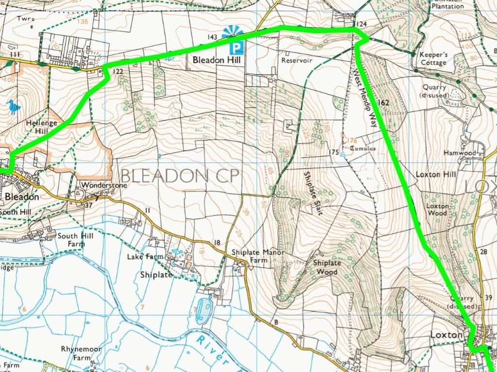
2 Uphill to Loxton 6.25 miles Start: Uphill Sluice. From the sluice follow the path straight ahead to Uphill and Walborough Local Nature Reserve passing the marina. This formal tarmac path eventually goes through a gate into a field. Leave the tarmac path and head straight ahead veering through a gap in the bushes around 20m to the right off the tarmac track. Go through the gap in the wall and then through the kissing gate to enter Walborough Nature Reserve. Follow the gently rising path uphill skirting the edge of the hill in an anti-clockwise direction overlooking the low lying land to your right with Brean Down in the Distance. As the path bears left around the hill cross over the start of the embankment and head down the slope (do not go through gate onto Bleadon Levels) until you come to the footbridge. Bear left after the bridge to re-join the tarmac path. Once on the tarmac, turn right and go through the gate and then immediately left through the gate onto the track. Follow this grassy track which eventually turns into a more defined track which eventually leads to a gate. Go through the gate and turn left to the main road. 1. At the main road turn right and walk along the pavement passing over a railway bridge. As the road bends left slightly, cross over and take the side road opposite. Follow this road as it bends to the right and then runs parallel to the main road. Just after the sports court you pass Coombe Farm then take a grassy path on your left between two hedges which heads directly uphill. Follow this path uphill as it bears left and becomes rocky underfoot. When you reach the stone track at the top turn right through the gate onto Purn Hill. Follow the fence on the left heading downhill between two hedgerows. Continue down the path (ignoring the gate on the left) to the bottom of the hill and go through gate and turn left then follow path to the road. Turn left down Purn way and go past the Farm Shop following the road round to the right. At the end of the road turn right onto the lane. On the second left hand bend keep straight ahead onto the narrow path until it meets another lane. 2. At the end of the lane turn left and follow Shiplate Road round to the right. As the road starts to rise above a grassy bank on the right, turn left up a steep lane. Go through the gate ahead onto Hellenge Hill. Take the right hand path and head up the hill diagonally right. Go through a gate then over a stile further on and keep straight across the field to the hedge. Go through the hedge and head diagonally up the hill on the path going around the buildings on the right hand side to meet the road. 3. At the main road turn right and walk along the pavement passing over a railway bridge. As the road bends left slightly, cross over and take the side road opposite. Follow this road as it bends to the right and then runs parallel to the main road. Just after the sports court you pass Coombe Farm then take a grassy path on your left between two hedges which heads directly uphill. Follow this path uphill as it bears left and becomes rocky underfoot. When you reach the stone track at the top turn right through the gate onto Purn Hill. 2
 to the bottom of the hill and go through gate and turn left then follow path to the road.")
3 Follow the fence on the left heading downhill between two hedgerows. Continue down the path (ignoring the gate on the left) to the bottom of the hill and go through gate and turn left then follow path to the road. Turn left down Purn way and go past the Farm Shop following the road round to the right. At the end of the road turn right onto the lane. On the second left hand bend keep straight ahead onto the narrow path until it meets another lane
4 3 4 4
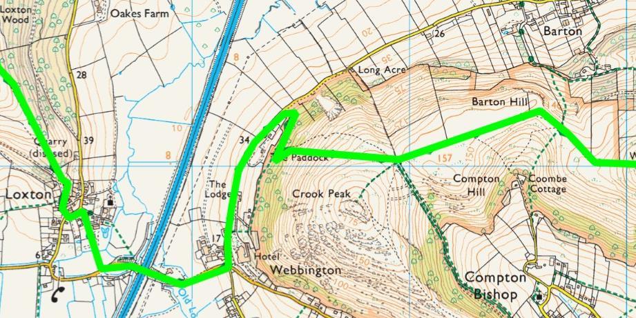
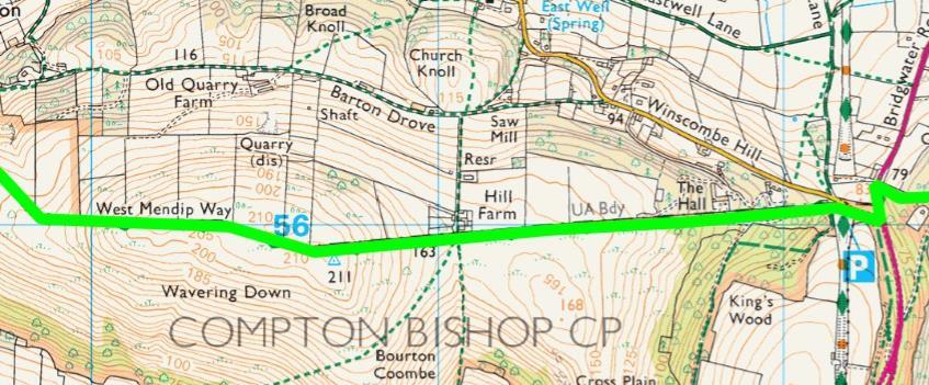
5 Loxton to Shipham 5.51 miles 4. As the path turns into a tarmac lane you pass a house on the left before bearing gently to the left passing the old hunting lodge. Immediately after the lodge, turn sharply right down a narrow path which opens up passing a seating area opposite the old school house on your left. On reaching the road turn left and walk along until you shortly take a right turn down Church Lane on your right. Walk along the gated footpath until the bottom and then exit the gate on the right crossing the lane at the bottom. Go up the few steps opposite and turn left following the path between the farm and the outbuildings. Go through the gate and across the field diagonally to the right heading to the gap in the trees opposite. Go through the gate beyond the trees and turn right along the lane until it reaches the main road. Turn left on the road walking over the motorway before gently rising uphill. Take the road on the left signposted Winscombe and follow this road for 0.75km passing The Lodge and The Paddock as it bends slightly to the right. Eventually you get to a small open area on your right. Turn right here up the slope and go through the gate. Go straight on following the path along the edge of the woods. After around 250m look for a wooden post in the woods as you reach a path on the left which takes you up a steep hill towards Crook Peak. The path starts to bear to the right and eventually reaches the flat ridge at the top. Follow the path to the corner of the drystone wall at the top. (To your right is Crook Peak which is worth a short detour for the fine views) Turn left and follow the wall to your left. Keep walking along the wall as it first turns to the right then the left. 5. Carry along as it rises up to the trig point on Wavering Down. Continue down from the trig point following the wall as it enters the woodland. Follow the path straight down until it reaches the car park at the bottom of the hill. 6. Go straight through the car park cross over the road and turn right onto the footpath through the trees. As it reaches the main road turn left and walk along the pavement. Just before the petrol station, cross over the road using the traffic island for safety. Walk up the lane opposite until you reach the farm entrance at the top. Turn left along the bridleway to the left following this undulating track for quite a while. Eventually the track starts to go downhill after another lane joins from the left. Keep straight on, ignoring the paths to the right and left in the dip and continue up the hill. As the track rises you quickly come across another track to your left and follow it along. Opposite the farm gate go over the stile on your right into the field. Follow the path straight across to the hedge on the far side. Go over the stile and head straight on through the next field keeping the hedge to your left. At the far end of the field take the steps down the steep hill through the woodland and cross over the bridge at the bottom. Take the path up the hill and to the left, go over the stile and along the short path to the road at Shipham. 5
6
7 7 6 7
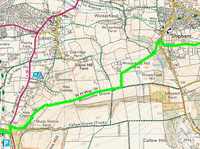
8 Shipham to Cheddar 5.85 miles 7. Turn right along the road and then immediately left up Tempears Way. Go up the road passing the benches on your left and at the top take the tarmac drive which takes you straight on. Go through the gate and along the drive. After the house at the end, go straight ahead where the tarmac ends and continue along the narrow path into the woods. Follow this path through the woods as it continues down and reaches the open field at the end. Turn left in the open area and head down the hill through the gruffy ground (old mineral workings). Continue down until you meet the stile made of steel poles and concrete posts. Ignore the stile and turn right in front of it following the field boundary on your left. Go through the metal kissing ate at the end of the field and along the short track beyond. At the end turn left on the lane and head down to the road at the bottom. Turn right on the road and head up the hill. 8. At the top of this road where it meets a lane crossing it, go straight ahead on to the path opposite and slightly right. Follow this path all the way down to the bottom and cross over the stream. Turn immediately right over the stream following this path keeping the stream to your right. After a short while the path starts to move away from the stream and head up the hill. Where this path meets he forest road, turn right and continue along as it gently rises up the hill. At the crossroads go straight across onto the track opposite and follow this all the way along to Tynings Farm and riding centre. Follow the track left around the stables and then right down to the road. 9. As you leave Tynings riding stables on the corner of the road turn left and walk along the road. Take the farm road on the right over the cattle grid and then take the right hand fork following the road past the farm as it turns into a stone track. At the end of the first field past the farm turn left through the gate and walk along the edge of the field following the wall to your right. Follow the boundary all the way to the end of this very long field. At the far corner go through the gate and follow the wide rocky path to the left down through the woods. 10. At the bottom of the hill go through the right hand kissing gate straight ahead. Continue along the rocky track and at the bottom follow the path as it turns to the right. Continue downhill passing the limestone cliffs on the right. After the cliffs the path bends to the right and turns into a more defined track On reaching a field gate on the track turn right go up a rocky path leading through woodland, go through a kissing gate and then downhill to a drystone wall. Go through a kissing gate in the wall and continue straight ahead up a series of steps and then continue ahead along the gorge walk route. Go through a kissing gate next to a dry stone wall and continue ahead downhill. As the path enters an open grassy field bear right away from the gorge, go past a field gate to go through a gap in the dry stone wall in the corner of the field. Turn immediately sharp left to go over a wooden stile, then after a few metres bear right and downhill through woods. Go through a kissing gate in a dry stone wall and turn 8

9 left, then through another kissing gate leaving the woods and continue downhill until the path joins a tarmac lane. Just before the tarmac turn sharp left onto a narrow path between walls and behind a cottage. Where the path emerges onto a tarmac lane turn left and follow the lane downhill to join a road. 11. Turn right onto the road and walk downhill through the lower gorge leading to Cheddar Village

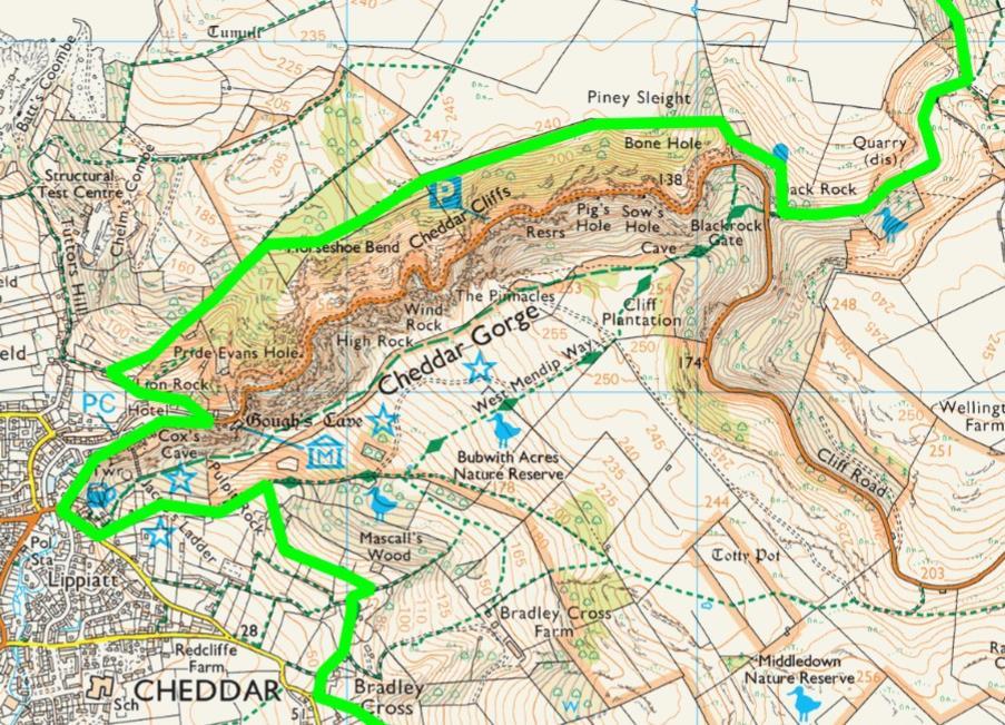
10
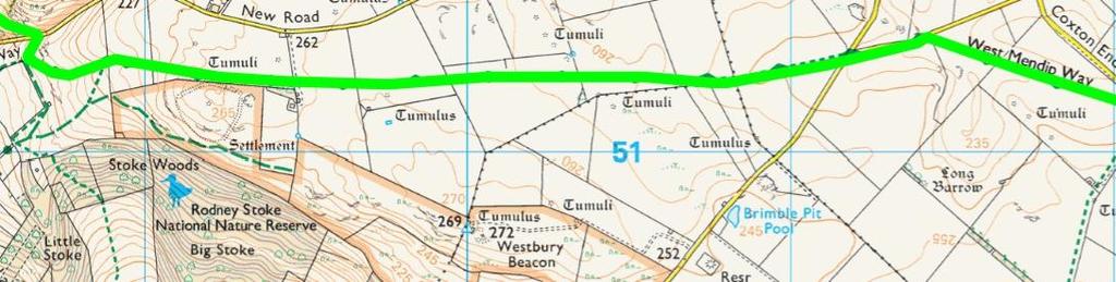
11 Cheddar to Priddy 5.49 miles 12. Just before the road bridge crossing the River Yeo turn left at the Black Dog Bar to head up the narrow Lippiatt Lane with cottages on the left. Turn left into Lynch Lane and follow this track to a public bridleway signpost and bear right. Follow the path uphill, through a pedestrian gate next to a field gate and continue ahead then turn right through a gate and follow a narrow lane. Turn right at the T-Junction at the end of this lane and then first left to go past a house called Owley and then along the track. 13. Just before reaching the road turn left and head up the lane. Follow the lane up the hill through a gate and on to a grassy track. Go through the next gate and continue up to the left before bearing right between two grassy banks. Go through the gate and up the track through the woods. At the top go through the gate and take the track directly opposite heading up the hill going through another gate and continuing on the track. As the track bears left take the small gate on the right. Follow the path across the field to a gate on the far side. Enter Draycott Sleights Nature Reserve and turn immediately right down the hill in front of the sign for the reserve do not take the rough path into the reserve. At the bottom turn left through the gate and follow the track all the way along to the road. 14. Go straight across the road over the stile and bear right on the path. When you reach the stile on your right turn left and take the path up the hill. Head up to the stile on the left at the top, cross and head diagonally right across the field to the stile. Head diagonally uphill to the right until the path meets the wall on the right and follow it along. Cross the next stone stile by the copse next to the farm house and cross straight crossing the stile and the following field over the next field. Go over the far stile then head diagonally right to meet the wall on the right and follow it along over two more stiles onto a road. Cross over the road and take the side road opposite until it bends to the left. 15. After the bend take the path on the right and cross the field heading diagonally to the left to the stile at the far side. Cross the stile and follow the path straight on up the shallow valley. Follow it to the left of the depressions and up to the stile at the top left hand side of the field. Go through the gate and stile onto the road and turn right walking along the road into Priddy. As you enter Priddy keep to the right hand side of the village green. 11

12
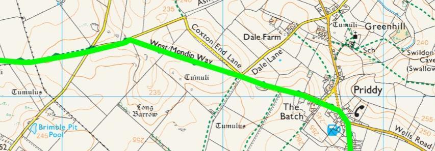
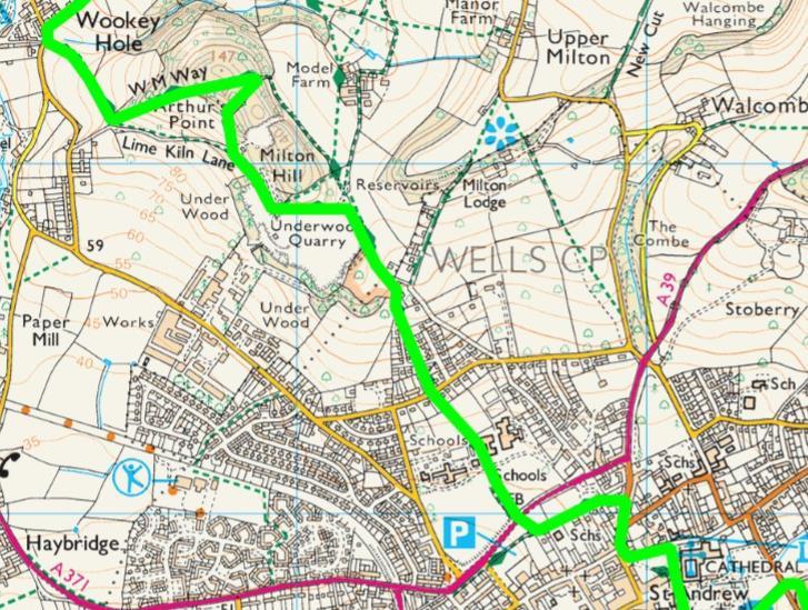
13 Priddy to Wells 5.55 miles 16. At the end of the village green turn right and then immediately right again down the side road leading past the Queen Victoria Inn. Keep going on the road past the houses and then just as you leave Priddy through the parish gateway take the path on the left before the road bears to the right. Walk down the left hand side of the field and then at the end turn right and walk along the top of the field. Go over the stile and continue straight on until you come to a stile o the left. Go over the stile and turn right and follow path as it winds along until you come to a track. Turn left on the track and follow it until another track comes in from the left. 17. Just after this junction turn onto the track on the right. At the farm take the right hand track passing between two buildings, Follow the path ahead round to the left and then turn right through the gate at the end. Go through the left hand gate and follow the hedge on your right until you reach a stile. Go over the stile and follow the path round to the right which talks you to the kissing gate at Ebbor Gorge Nature Reserve. Take the path down the hill through the reserve. Go through the woods crossing a path and then turn left just before the path to the viewing point. Go down the path and the steps until you reach a flat path at the bottom. Turn left at this path and leave the woods by the stile and follow the path down the small valley to the road. 18. Turn Left on the road and follow it along and past the Wookey Hole Caves. As the road bends to the right by School Hill go through the gap in the wall opposite and up the narrow path. Go over two stiles and then head straight across the next field to the hedge on the right. Go over the stile to the road. Turn right in the field and follow the hedge on the right. Go over the stile and keep straight ahead until you come to the road. Turn right down the road until the junction at the bottom. 19. Turn left and take the path on the left. Go straight up the hill following the hedge then go through the kissing gate and follow the path. At the end of the path take the gate on your left just before the end. Turn diagonally left in the field and follow the path up the spur on the left. Go through the gate and continue up to the top of the hill. At the top of the hill bear right and go down through the woods to the gate in the corner. Go through the gate and follow the narrow path on the left hand side of the field. At the far end go through the kissing gate and straight ahead passing the lime kilns on your left. Turn left on the lane and follow it along to the end. Turn right on the road it meets and go through the gate and continue along. Where the road bends left take the path on the right and follow the track ahead down the path to the right of the house and follow it down the hill. Cross over the road and keep on the path opposite until you reach another road. Take the path opposite and slightly left into the field behind the houses and head over to the school grounds straight ahead. Go through the school gate and cross straight over the school grounds in a straight line. Follow the tarmac path until you reach the footbridge over the road. After the bridge turn left after the skateboard park and go past the sports pitches on the left to where the path joins the road. Continue along road and as it bends to the left take the lane on your right. Turn left immediately down another lane and follow to the end. Turn right onto 13

14 the street and down to the mini roundabout. Turn right at the roundabout and head down to the traffic lights. Turn left down Sadler Street and then left through the archway into cathedral Green. Keep along the left hand side until you reach the Museum and the end of the West Mendip way

15
16
START - UPHILL BEACH. (tidal!) The West Mendip Way is route-marked with these round blue signs
 The West Mendip Way is route-marked with these round blue signs") START - UPHILL BEACH Start Times: 10:30 11:15 12:00 Please allow sufficient time to check in with the marshals Start on the beach at the high water line (tidal!) The West Mendip Way is route-marked with
START - UPHILL BEACH Start Times: 10:30 11:15 12:00 Please allow sufficient time to check in with the marshals Start on the beach at the high water line (tidal!) The West Mendip Way is route-marked with
Leaden Boot Challenge ROUTE INSTRUCTIONS
 Leaden Boot Challenge ROUTE INSTRUCTIONS Section 1 Alstonefield to Ilam From the village hall car park turn R then L and pass through the village keeping to the R to enter Church Street. Pass the Church
Leaden Boot Challenge 2016 ROUTE INSTRUCTIONS
 Leaden Boot Challenge 2016 ROUTE INSTRUCTIONS Section 1 Alstonefield to Ilam (CP2) From the village hall car park turn R then L and pass through the village keeping to the R to enter Church Street. Pass
Slad over to Pitchcombe and back
 The walk climbs up from Slad over Wickridge Hill, descends to near Pitchcombe, then climbs back over Wickridge hill and round the back of Slad. Page 1 Start Point: SO 8718 0732 The Woolpack, Slad Length:
CWMGIEDD FROM ABERCRAVE
 Abercrave to Cwmgiedd Walk Page 1 Starting from The Abercrave Inn. Grid Ref: SN 824128 From the Abercrave Inn, an 11.3km (7 miles) walk to the foothills of the Cribarth Mountain, then through forest to
HARDMOORS 55 RACE ROUTE 2018 HELMSLEY - GUISBOROUGH
 HARDMOORS 55 RACE ROUTE 2018 HELMSLEY - GUISBOROUGH HELMSLEY - CHECKPOINT 1 (WHITE HORSE) 1. Leave RACE START, continue ahead on road (Baxtons Sprunt) At crossroads turn right down Canons Garth eventualy
BURGHCLERE PARISH RIGHTS OF WAY
 BURGHCLERE PARISH RIGHTS OF WAY Full descriptions compiled by Neill & Miggie Bruce All photos Miggie Bruce FP23 on Ridgemoor, looking south, with FP22 crossing by the bush FP1. From C183 Aldern Bridge
Pontfadog. Walk A. Walk A
 Walk A A Bird s eye view of the village 2km. (1 1 /2 miles); height gain 45m. (150ft) about 45 minutes. Six minutes walk along the main road towards Glyn Ceiriog reach a signpost to Llwynmawr. Take the
Beautiful Walks from the Blue Ball Inn
 Walk No. 5 RIVER VALLEYS AND MOOR Countisbury, Watersmeet, Hillsford Bridge, Cheriton, Shilstone Hill, Rockford and Chiselcombe. 8.5 MILES APPROX. Walking time four and a half hours approx. OS 1;25,000
Ardingly Lake, Ouse Valley, Borde Hill
 point your feet on a new path Ardingly Lake, Ouse Valley, Borde Hill Distance: 14 km=9 miles or 12½ km=8 miles Region: West Sussex Author: Hautboy Refreshments: Borde Hill Map: Explorer 135 (Ashdown Forest)
Bewl Water & the High Weald
 1 Bewl Water & the High Weald Stonegate station - Stonegate - Wallcrouch - Newbarn - Cousley Wood - Wood's Green - Wadhurst station Length: 9 ½ miles (15.3km) Underfoot: Large portions of this path are
Hindhead, Keffolds Copse and Gibbet Hill
 point your feet on a new path, Keffolds Copse and Gibbet Hill Distance: 6 km=4 miles Region: Surrey Author: Schwebefuss Refreshments: Punch Bowl Café moderate walking Date written: 14-apr-2015 Last update:
ID: 283 Distance: 6.2 miles Height gain: 500 Metres Map: Explore OL 19 Contributor David and Chris Stewart
 Walkingworld Wild Boar Fell ID: 283 Distance: 6.2 miles Height gain: 500 Metres Map: Explore OL 19 Contributor David and Chris Stewart Features Birds, Great Views, Hills or Fells Description: Wild Boar
Chevening and the North Downs
 1 Chevening and the North Downs Dunton Green station - Chipstead - Chevening - Knockholt - Hawley's Corner - Botley Hill - Oxted station Length: 12 ¼ miles (19.7 km) Underfoot: Portions of the walk are
HARDMOORS ROUTE DESCRIPTION
 HARDMOORS 60 2016 ROUTE DESCRIPTION RACE START (GUISBOROUGH) - CHECKPOINT 2 (SALTBURN) DISTANCE 9 MILES CUT OFF TIME 1030 GRID REF OS 666 208 1. Leaving the Sea Cadets Hall, turn left onto the road and
Ystwyth and Rheidol Bridleway Routes. Route 2:Llanilar Circular
 Ystwyth and Rheidol Bridleway Routes Route 2:Llanilar Circular Route overview and terrain: A long circle using connecting ridges with fine views to link the Rheidol and Ystwyth river valleys. The route
Hadleigh Castle and Chalkwell Oaze
 1 Hadleigh Castle and Chalkwell Oaze Benfleet station Hadleigh Park Hadleigh Castle Leigh-on-Sea Chalkwell station A short stroll through the lush woods of Hadleigh Park high above the Thames-side marshes,
Walk 1. Cotswold Water Park. Gateway Centre to Cerney Wick, railway track to Lake 6, Gateway Centre.
 Cotswold Water ark Walk way A Swindon/ Cirencester Thomas and Severn Canal way to Cerney Wick, railway track to Lake, way. Spine Road East Hotel Time: hours (short walk km) Distance: km A level walk along
Sponsored by. statestreet.com
 /STATESTREETISLANDWALK #ISLANDWALKJSY Sponsored by statestreet.com Important Information If you forget everything else PLEASE remember the following.» Remember to check OUT of every checkpoint» If you
This path goes past an old tree nursery and sawmill. After 800m it crosses over a lane. Follow the bridleway fingerpost into the woods.
 FRENSHAM PONDS 11K CIRCULAR TRAIL 2½ HRS GU10 2DA This magnificent heathland trail starts in woodland and then brings you out onto the open heather of Frensham Common, with no roadwork! The route runs
Beautiful Walks from the Blue Ball Inn
 Walk No. 2 WINSTONS WALK Countisbury, Wind Hill, Watersmeet, Ash Bridge and Winston s path. 5 Miles approx. Walking time- Two and a half hours approx. (Not including Breaks) OS 1:25,000 Sheet 64/74 Lynton
Mapledurham, Gallowstree and Shepherd s Green
 Mapledurham, Gallowstree and Shepherd s Green Pangbourne station Mapledurham Gallowstree Common Satwell Shepherd s Green Grey s Court Henley-on-Thames Length: 15 ½ miles (24.8km) Underfoot: Minor roads
GRINDLEFORD GALLOP 2018
 GRINDLEFORD GALLOP 2018 Route Information The Grindleford Gallop follows a fixed 21 mile route through the lanes and paths of Derbyshire. All competitors must follow this route. An OS map of the area with
The 34 th Poppyline Marathon
 The 34 th Poppyline Marathon Saturday 9th June 2018 - Route Description Emergency number: 07906 404673 or 07597 052572 Ahd - Ahead BL - bear left BR - bear right BW - bridleway Cont - continue FB - footbridge
Tour Of Tameside The alternative tameside trail
 Tour Of Tameside The alternative tameside trail A 30 mile walk around the borough of Tameside taking in the Valleys of the Medlock, Etherow and Tame. The whole walk can be completed in one day by anyone
Description for the Round Rotherham 8 December 2007
 Directions: L left R right ½L, ½R half left, half right X cross X Rds cross roads SA straight Codes: BR bridge FP footpath FB footbridge RWY railway CP car park RD road Description for the Leave Event
The Sudbury Branch Walks 1-4
 The Sudbury Branch Walks 1-4 Sudbury Branch Walks From Sudbury to Marks Tey The gentle declivities, the luxuriant meadow flats sprinkled with flocks and herds... the sound of water escaping from the mill
Hay Wood, Rowington and Baddesley Clinton - Warwickshire
 Hay Wood, Rowington and Baddesley Clinton - Warwickshire Starts at Lay-by alongside Hay Wood 2 hours 30 minutes 5.5miles 8.8km Leisurely ID: 0.683 Developed by: John Clift Checked by: Andy Page www.ramblersroutes.org
Self-Guided Walk Malham, Gordale and Malham Tarn
 Self-Guided Walk Malham, Gordale and Malham Tarn Combine all the major geological attractions of Malham in this walk and hopefully leave enough time to enjoy the cafes, pubs and shops of the village. Malham
Britain s oldest surviving water-balanced cliff lift
 44 3.6 Saltburn by the Sea to Sandsend Map panels 3 and 4 Distance 17 miles (27½ km) Terrain mostly grass and field paths which can be muddy; some pavement, beach and shore Grade undulating route, with
Torrance. Mapped Heritage. The following maps demonstrate the spatial strategy for the Torrance trails. Trail themes
 Torrance The following maps demonstrate the spatial strategy for the Torrance trails. The heritage and proposed trails are presented on two maps per area: Map 2A - Existing heritage locations Map 2B -
Gomshall station - Abinger Hammer - Abinger Common - Friday Street - Leith Hill - Coldharbour - Holmwood station
 1 To Leith Hill Gomshall station - Abinger Hammer - Abinger Common - Friday Street - Leith Hill - Coldharbour - Holmwood station Important note: this walk cannot currently be done wholly by train on a
A Circular Walk from Chapel Carn Brea
 A Circular Walk from Chapel Carn Brea 4.3 Miles A Walk Visiting Five Historic Ancient Sites This circular walk offers the possibility of several alternatives, depending on the walker s available time and
Penn Common and Bramshaw Wood
 Trail Activity Type Terrain Author Distance Ascent Location : HAMPTR0025 : Walk : Pub : Towpaths and Cycle Tracks : Anne-Marie Edwards : 5.3 miles / 8.5 kms : 381 feet / 116 metres : SU253173 / SP5 2BZ
Reigate Hill and Gatton Park
 point your feet on a new path Reigate Hill and Gatton Park Distance: 11½ km=7 miles easy-to-moderate walking or 2 walks of 6½ km=4 miles and 5½ km=3½ miles Region: Surrey Author: Schwebefuss Refreshments:
Bentley and Isington Mill Lower Froyle: The Anchor
 point your feet on a new path and Isington Mill Lower Froyle: The Anchor Distance: 12 km=7 miles Region: Hampshire Author: Botafuego Refreshments: Lower Froyle, easy walking Date written: 6-may-2012 Date
BISHOPSTONE CIRCULAR WALK
 BISHOPSTONE CIRCULAR WALK 4½ miles (7¼ km) - allow 2 hours (see maps on final pages) Introduction This walk is within the North Wessex Downs Area of Outstanding Natural Beauty and starts from the small,
Singleton and the South Downs
 point your feet on a new path Singleton and the South Downs Distance: 13½ km=8½ miles easy walking with a few steeper sections Region: West Sussex Author: Hautboy Refreshments: Singleton, Hill Barn Date
Baggy Point, Croyde, North Devon
 Baggy Point, Croyde, North Devon A walk using the South West Coast Path that is likely to be suitable for people with impaired mobility or with a pushchair, wheelchair, or mobility scooter. The Coast Path
Friday Street, Leith Hill, Holmbury Hill
 point your feet on a new path Friday Street, Leith Hill, Hill Distance: 12 km=7 miles easy-to-moderate walking + optional tour of Hill: 1½ km=1 mile Date written: 27-oct-2011 Region: Surrey Author: Schwebefuss
The Hundred Parishes
 The Hundred Parishes Walks from railway stations number 3 3 miles (5kms) circular walk from Stansted Mountfitchet Start & finish: Stansted Mountfitchet station. Ordnance Survey Explorer Map 195. Grid Reference:
Freefolk and Whitchurch
 Trail Activity Type Terrain Author Distance Ascent Location : HAMPTR0026 : Walk : Tea Shop : Towpaths and Cycle Tracks : Jean Patefield : 5.6 miles / 9 kms : 377 feet / 115 metres : SU487488 / RG28 7NN
Lewes and the South Downs
 point your feet on a new path and the South Downs Distance: 0 km=1½ miles moderate walking with long easy stretches Region: East Sussex Author: Hautboy Refreshments: Date written: 8-apr-013 Map: Explorer
Ranmore Common and Polesden Lacey
 point your feet on a new path Ranmore Common and Polesden Lacey Distance: 9½ km=6 miles Region: Surrey Author: Fusszweig Refreshments: Polesden Lacey easy walking Date written: 20-dec-2016 Last update:
Approximate distance: 5.5 miles For this walk we ve included OS grid references should you wish to use them. Start. End
 Approximate distance: 5.5 miles For this walk we ve included OS grid references should you wish to use them. Start End 2 1 5 4 6 3 N W E 7 S Reproduced by permission of Ordnance Survey on behalf of HMSO.
Fetcham Downs and Bocketts Farm A magical teashop walk
 point your feet on a new path Fetcham Downs and Bocketts Farm A magical teashop walk Distance: 3 km=2 miles or 4 km=2½ miles Region: Surrey Author: Fusszweig Refreshments: Bocketts Farm easy walking Date
Gomshall station - Abinger Hammer - Abinger Common - Friday Street - Leith Hill - Coldharbour - Holmwood station
 1 To Leith Hill Gomshall station - Abinger Hammer - Abinger Common - Friday Street - Leith Hill - Coldharbour - Holmwood station Important note: this walk cannot currently be done on a Sunday due to the
Mt Kuring-gai Track to Berowra station
 Mt Kuring-gai Track to Berowra station 4 hrs 15 mins 9.7 km One way Hard track 4 553m This walk explores three valleys, with great displays of wild flowers in spring, and some nice sandstone overhangs.
Merritts Traverse. 1928m
 Merritts Traverse 3 hrs Hard track 5.8 km Circuit 4 167m This walk starts with a scenic journey to the top of the hill on the chairlift. Starting along Merritts Nature walk, this walk soon detours down
COSTA BLANCA MOUNTAIN WALKERS - WALK DESCRIPTION. Visit for more walks descriptions in Spain
 Visit www.walksinspain.org for more walks descriptions in Spain Walk description originally prepared by:- Ralph Phipps Last Updated 15 th July 2016 Title of Walk Location of Start (include name of nearest
Walk 1: Highfield, Lob Wood and The River Wharfe
 Walk 1: Highfield, Lob Wood and The River Wharfe Start: The Hen Pen Garden, Main Street, Addingham LS29 0NS, SE 077 498. Alternative Start: Near Bolton Bridge SE 071 525 (see page 6). Full walk: 4.5 miles
Aeron & Arth walks 4 walks for all the family to enjoy
 Aeron & Arth walks walks for all the family to enjoy Please take note that the maps illustrating these walks are intended as a rough guide only. You should use the most recent version of the relevant Ordnance
Centurion Way Chichester
 Centurion Way Chichester Work book of plans to show details of the Centurion Way, its links, and potential developments and enhancements from linking to the South Downs National Park all the way to the
Brightling, Dudwell Valley, Bateman s Forests and Follies
 point your feet on a new path Brightling, Dudwell Valley, Bateman s Forests and Follies Distance: 15 km=9½ miles Region: East Sussex Author: Stivaletti Refreshments: Woods Corner, Burwash Weald moderate
Mersey Valley Timberland Trail
 Route Pack Page 1 Route Summary A long distance linear walk on roads and country paths linking town and countryside to parks, woodlands and other open spaces. Grade Distance Accessibility Allow Start Map
Ivinghoe Beacon and the Grand Union
 1 Ivinghoe Beacon and the Grand Union Cheddington station - Horton Wharf - Ivinghoe - Ivinghoe Beacon - Bridgewater Monument - Aldbury - Tring station Length: 11 ¼ miles (18.3km) Underfoot: The first mile
Beachy Head and Eastbourne
 point your feet on a new path Beachy Head and Eastbourne Distance: 2 km=4½ miles Region: East Sussex Author: Stivaletti moderate walking Date written: 25-jun-200 & 6-jun-205 Last update: 28-feb-208 Refreshments:
Aston Rowant Discovery Trail
 The walk was developed by Aston Rowant Parish Council. The Trail is stile-free and fully way-marked. The circular route is 5.3m but with the extension to a pub and hotel 6.2m. Key Main Aston Rowant Discovery
Bentley station - Alice Holt Forest - Frensham Great Pond - Rushmoor - Pitch Place - Gibbet Hill - Haslemere station
 1 Devil s Punch Bowl and Surrey Heaths Bentley station - Alice Holt Forest - Frensham Great Pond - Rushmoor - Pitch Place - Gibbet Hill - Haslemere station Length: 13 ¾ miles (22.0 km) Underfoot: Almost
Wicklow Mountains Path Survey
 Wicklow Mountains Path Survey Glenmacnass Tonelagee Start to Finish: O 114 030 to O 085 016 Altitude (lowest highest): 370m 817m Weather: Sunny day, hot Access: Military Road, Glenmacnass Surveyed by:
Distance: 18 km=11 miles or 12½ km=7½ miles or 9 km=5½ miles
 point your feet on a new path The Devil s Dyke Distance: 18 km=11 miles or 12½ km=7½ miles or 9 km=5½ miles Region: West Sussex Author: Hautboy Refreshments: Devil s Dyke, Fulking, Poynings moderate ing
Girrakool to Wondabyne station
 Girrakool to Wondabyne station 4 hrs Hard track 9.5 km One way 4 438m This walk starts from the Girrakool picnic area and winds south, through the Brisbane Waters National Park. The walk crosses some long
Medway Valley Orchards
 1 Medway Valley Orchards East Farleigh station - Kettle Corner - Farleigh Green - Buston Manor - Yalding - Yalding station Length: 6 ¾ miles (10.9km) Underfoot: Generally, this is a walk on good paths,
beach. Make the ford and follow the trail out to the junction with Red Creek Tr in an open grassy area.
 Description: This is a moderate to slightly strenuous 22.8 mile backpack (add 2.6 miles if you do the packless out and back to the Lion s Head) that will have you exploring nearly every thing that is The
s point your feet on a new path
 s point your feet on a new path Arundel: Park, Hills and Forests Distance: 20 km=12½ miles Region: West Sussex Author: Hautboy Refreshments: Arundel, Houghton, Whiteways Lodge moderate walking Date written:
For more information and to buy this book click here ISBN: CICERONE. Guides for walkers, trekkers, mountaineers, climbers and cyclists
 For more information and to buy this book click here ISBN: 9781852844103 CICERONE Guides for walkers, trekkers, mountaineers, climbers and cyclists www.cicerone.co.uk SALÈVE AND VALLÉE VERTE SALÈVE WALK
river point your feet on a new path
 river point your feet on a new path Frensham and Bourne Wood Distance: 13 km=8 miles or 11 km=7 miles easy walking with a few steep gradients Region: Surrey Author: Schwebefuss Refreshments: Shortfield
Approximate distance: 7.5 miles For this walk we ve included OS grid references should you wish to use them.
 Approximate distance: 7.5 miles For this walk we ve included OS grid references should you wish to use them. 6 5 7 8 4 1 2 Start End N 3 W E S Reproduced by permission of Ordnance Survey on behalf of HMSO.
Congewai Track Head (East) to Watagan Headquarters
 to Watagan Headquarters") Congewai Track Head (East) to Watagan Headquarters 7 hrs Hard track 17.2 km One way 4 973m This full day walk starts from the Congewai valley trackhead (east) and follows the Great North Walk up into the
Congewai Track Head (East) to Watagan Headquarters 7 hrs Hard track 17.2 km One way 4 973m This full day walk starts from the Congewai valley trackhead (east) and follows the Great North Walk up into the
Woodland Walk If you enjoyed this walk there are two others available in the same area.
 The Woodland Walk 11-12 kilometres (7-8 miles) 4-5 hours Terrain: some easy hills Can be slippery when wet 5 stiles Unsuitable for a pushchair/wheelchair Uses OS map 197 Parking: Pulborough Station and
Victoria Falls Lookout to Blue Gum Forest
 Victoria Falls Lookout to Blue Gum Forest 8 hrs Experienced only 13.8 km One way 5 112m This long day-walk follows a remote track down from Victoria Falls lookout, passing the waterfall, and into the Grose
White Horse Trail Route directions (Clockwise) split into 10 section with an alternative for the Alton Barnes to Cherhill section
 split into 10 section with an alternative for the Alton Barnes to Cherhill section") White Horse Trail Route directions (Clockwise) split into 10 section with an alternative for the Alton Barnes to Cherhill section S1 White Horse Trail directions Westbury to Bulkington Maps: OS Explorer
White Horse Trail Route directions (Clockwise) split into 10 section with an alternative for the Alton Barnes to Cherhill section S1 White Horse Trail directions Westbury to Bulkington Maps: OS Explorer
Wicklow Mountains Path Survey
 Wicklow Mountains Path Survey Ballinacor Croaghanmoira Fananierin Start to Finish: T 11723 86602 to T 11175 89057 Altitude (lowest highest): 385m 664m Weather: Hot Access: Coolgarrow forest entrance Surveyed
A Tour of the Valle del Gizio
 Walk 25 A Tour of the Valle del Gizio Walking time 5hrs 30mins (4hrs if Colle Mitra is omitted) Difficulty 2 (likely to be snowbound in winter months); 1 (if Colle Mitra is omitted) Ascent/descent 570m/570m
Self-Guided Walk Langdale Pikes. Start & Finish: NT car park (free to members) at Sticklebarn - on the right just beyond the New Dungeon Ghyll hotel.
 at Sticklebarn - on the right just beyond the New Dungeon Ghyll hotel.") Self-Guided Walk Langdale Pikes Key Information These mountains form a collection of spires and cliffs on the north side of Langdale. This walk visits four of the main tops Pavey Ark, Harrison Stickle,
Self-Guided Walk Langdale Pikes Key Information These mountains form a collection of spires and cliffs on the north side of Langdale. This walk visits four of the main tops Pavey Ark, Harrison Stickle,
Victoria Falls and Grose Valley to Blackheath Station
 This walk explores a fantastic section of the Grose Valley. Starting above Victoria Falls, the walk explores the cascades before dropping into the valley for the first nights rest at Burra Korain campsite.
Chess & Gade. Chalfont & Latimer Station - Latimer - Chenies - Sarratt - Kings Langley Station. Length: 8 ¾ miles (14.25km)
") 1 Chess & Gade Chalfont & Latimer Station - Latimer - Chenies - Sarratt - Kings Langley Station Length: 8 ¾ miles (14.25km) Underfoot: Well-trodden paths, mainly firm in all weather conditions, though
1 Chess & Gade Chalfont & Latimer Station - Latimer - Chenies - Sarratt - Kings Langley Station Length: 8 ¾ miles (14.25km) Underfoot: Well-trodden paths, mainly firm in all weather conditions, though
Girrakool to Wondabyne station via Pindar caves
 Girrakool to Wondabyne station via Pindar caves 7 hrs 30 mins 18.1 km One way Experienced only 5 741m This walk starts from the Girrakool picnic area and winds south, following Piles creek into the Brisbane
Approximate distance: 4.5 miles For this walk we ve included OS grid references should you wish to use them. Start. End
 Approximate distance: 4.5 miles For this walk we ve included OS grid references should you wish to use them. 2 1 Start End 4 3 N W E S Reproduced by permission of Ordnance Survey on behalf of HMSO. Crown
Scenic Railway to Ruined Castle
 Scenic Railway to Ruined Castle 7 hrs 30 mins 12.4 km Return Hard track 4 963m This is a very popular, full day walk, in the Katoomba Area, offering great views of the valley. The walk follows the edge
Basingstoke Canal and Dogmersfield
 point your feet on a new path? Basingstoke Canal and Dogmersfield Distance: 11 km=7 miles easy ing or 2 s of 7½ km=4¾ miles and 5¼ km=3¼ miles Region: Hampshire Author: Botafuego Refreshments: The Barley
Grid Reference: TQ
 James & Penny Biggs present The Walk: Just 3 miles of easy walking mostly on well-made paths, the walk is suitable for buggies with only two stiles to cross. This lovely walk passes through the picturesque
3.1 Bowness-on-Solway to Carlisle
 3.1 Bowness-on-Solway to Carlisle Map panel 1 Distance 15 miles (24 km) Terrain minor roads, tracks, field paths and riverside footpath, muddy in places Grade easy, with gentle gradients on undulating
Kingley Vale and the Downland Churches
 point your feet on a new path Kingley Vale and the Downland Churches Distance: 21 km=13 miles or 10½ km=6½ miles Region: West Sussex Author: Hautboy Refreshments: Stoughton, Walderton moderate walking
Berowra to Cowan via Berowra Waters
 Berowra to Cowan via Berowra Waters 6 hrs Hard track 12.9 km One way 4 884m With train station at each end this walk explores the ridges and valleys around Berowra Waters. There are plenty of excellent
Cuxton, Ranscombe and Cobham
 1 Cuxton, Ranscombe and Cobham Cuxton station - Ranscombe - Cobham Park - Cobham - Sole Street station Length: 5 ¾ miles (9.4 km) Underfoot: Most of this walk is on well-made paths or tracks, with a few
Beamers Trail. Walk No.1. 6 miles. (easy with some moderate ascents and descents)
") Beamers Trail Walk No.1 6 miles (easy with some moderate ascents and descents) 1 BEAMERS TRAIL 6 miles (easy with som WALK The Warpers Trail forms part of the long distance Witton Weavers Way. This is
Beamers Trail Walk No.1 6 miles (easy with some moderate ascents and descents) 1 BEAMERS TRAIL 6 miles (easy with som WALK The Warpers Trail forms part of the long distance Witton Weavers Way. This is
Eastbourne. Alfriston 3¾ 6 3¾ 6. Birling Gap. Exceat
 3.8a Alfriston to Eastbourne (footpath) Map panel 6 (page 64) Distance 10½ miles (17 km) Terrain valley walk initially, first along riverbank path then hillside paths above, including stretch through forest;
Broxbourne Woods Brickendon, Ermine Street, Wormley West End
 point your feet on a new path Broxbourne Woods Brickendon, Ermine Street, Wormley West End Distance: 10 km=6 miles (+ 1.2 km=0.8 mile for north pub) easy walking or two walks of 7 km=4½ miles (south) and
The Copper Horse Lodge, Windsor Park George III statue and view of Windsor Castle Andy Oakes Julian P Guffogg Don Cload
 Trail Activity Area Type(s) Author Distance Ascent Location : BRKSTR0008 : Walk : Windsor and the South East : Country Escape : Andy Oakes : 5 miles / 8.1 km : 239 feet / 73 metres : SU947727 / SL4 2BT
San Miguel to Caserio de la Hoya Circular (San Miguel)
") Tenerife Sur: Short Walks Under 10 km San Miguel to Caserio de la Hoya Circular (San Miguel) Route Summary An informative and scenic walk back in time from San Miguel to below El Roque, overlooking the
Tenerife Sur: Short Walks Under 10 km San Miguel to Caserio de la Hoya Circular (San Miguel) Route Summary An informative and scenic walk back in time from San Miguel to below El Roque, overlooking the
Bob Graham Detailed Notes
 Bob Graham Detailed Notes These notes are intended to provide a short summary of the best line to take in terms of time and effort. The notes are meant to be read in conjunction with the OS Explorer OL
West Hoathly, Balcombe & Bluebell Railway Steam and Seed Bank
 point your feet on a new path West Hoathly, Balcombe & Bluebell Railway Steam and Seed Bank Distance: 8 km= miles or walks of 9½ km=6 miles and 0 km=6½ miles Region: West Sussex Author: Stivaletti Refreshments:
Firle, Alciston and the South Downs
 point your feet on a new path Firle, Alciston and the South Downs Distance: 16 km=10 miles Region: East Sussex Author: Hautboy Refreshments: Alciston, Firle moderate walking with long easy stretches Map:
Darwin s gigantic blunder
 Trail Darwin s gigantic blunder Explore how ice shaped the landscape and why Charles Darwin made a nice mess of Glen Roy Time: 1hr 10 mins Distance: 2 miles Landscape: rural At Glen Roy a curious feature
Bonaqua Mountain Hardware Action Sprint 2013 Discovery Bay,Lantau The Course Route
 Bonaqua Mountain Hardware Action Sprint 2013 Discovery Bay,Lantau The Course Route The start is inside the Discovery Bay plaza and leads out to the main sandy beach where you will run to the end of the
2016 ROAD BOOK THE MONTANE LAKELAND 100 & 50 ULTRA TOUR OF THE LAKE DISTRICT. The official map used is Harvey 1:40:000
 2016 ROAD BOOK THE MONTANE LAKELAND 100 & 50 ULTRA TOUR OF THE LAKE DISTRICT The official map used is Harvey 1:40:000 KEY: R=right L=left N=north S=south W=west E=east CP=checkpoint FB=footbridge SP=signpost
Jerusalem Bay Track (Cowan to Brooklyn)
") Jerusalem Bay Track (Cowan to Brooklyn) 5 hrs 30 mins 13.4 km One way Hard track 4 654m This Cowan to Brooklyn Station walk is a popular section of the Great North Walk, with scenery ranging from foreshore
Jerusalem Bay Track (Cowan to Brooklyn) 5 hrs 30 mins 13.4 km One way Hard track 4 654m This Cowan to Brooklyn Station walk is a popular section of the Great North Walk, with scenery ranging from foreshore
Bradfield, Bucklebury, Stanford Dingley A Drink with the Middletons
 point your feet on a new path, Bucklebury, Stanford Dingley A Drink with the Middletons Distance: km=3 miles or 0 km= miles or 8 km= miles easy-to-moderate walking Region: Berkshire Author: MacMeadow Refreshments:
Leura Cascades to Gordon Falls Reserve
 Leura Cascades to Gordon Falls Reserve 1 hr 15 mins 1.8 km One way Moderate track 200m From Leura Park to Gordon Falls Park, this diverse walk offers fantastic views of the Jamison Valley, as well as two