Bewl Water & the High Weald
|
|
|
- Gordon Townsend
- 6 years ago
- Views:
Transcription
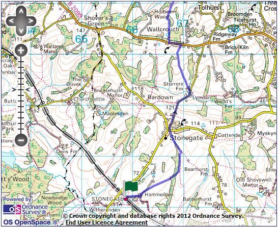
1 1 Bewl Water & the High Weald Stonegate station - Stonegate - Wallcrouch - Newbarn - Cousley Wood - Wood's Green - Wadhurst station Length: 9 ½ miles (15.3km) Underfoot: Large portions of this path are on field paths and woodland routes, which after rain will inevitably be squelchy. However, the clay soils of the Weald mean you are unlikely to encounter extended deep mud. There are also significant sections on minor roads in between the paths to clean your boots on! Terrain: The route cuts across the valleys and hills of the Weald, meaning that much of the route is either ascending or descending, mainly gently but with occasional steeper sections. Maps: 1:50,000 Landranger 188 Maidstone & Royal Tunbridge Wells; 1:25,000 Explorer 136 High Weald. Getting there: Southeastern operate an hourly service every day to Stonegate from London Charing Cross (1hr 11), via Waterloo East (1hr 8), London Bridge (1hr 3) and Orpington (47min) for connections from London Victoria. Useful websites: The route uses parts of the Sussex Border Path and wanders along the shores of Southern Water's Bewl Water reservoir. Getting home: Wadhurst is on the same line as Stonegate, but as a larger settlement gets double the service, with two trains per hour daily to London Charing Cross (1hr 3) via Orpington (38mins) for connections to London Victoria, London Bridge (55mins) and Waterloo East (59 mins). Fares: An off-peak return to Stonegate for (child 10.35, railcard 13.65).
2 2
3 3
4 4 Route description Alighting at Stonegate station, in pretty much the middle of nowhere, with hens pecking around the Italianate station house, exit the platform and head left, immediately heading right on a surfaced farm track, following a footpath sign. The isolated nature of Stonegate station is common for stops on this line - it was built between 1846 and 1853 through difficult terrain and in a hurry (the Southern railway had already obtained a route to Hastings, and the Southeastern wanted part of the market), leading to a route that was suboptimal for serving intermediate locations. Where exactly Stonegate station is meant to serve has always been something of a question - when it opened in 1851 it was called Witherenden, named after a cluster of houses up the road. A year later it was renamed Ticehurst Road, after the distant village that is the main settlement in this area. In 1947 it became Stonegate, a village one mile away, and which primarily grew up after the arrival of the railway. Reaching the red brick Hammerden farmhouse, next to its large pond, follow the track swinging to the right in front of the house. Before you reach a second house, turn left at a waymark post on a hedged track. On reaching a gate, the footpath leaves the track to the right (waymark) through a footgate and into the fields. Head diagonally across the field towards a clump of trees in the far corner. Just beyond the trees, which hide a small pond, pass through the waymarked gate into the next field. Continue at a similar angle, descending gently towards the narrow wooded valley. A stile in the fence ahead leads you steeply down to ford a small side stream. From this stream, a clear path leads through the trees of Church Wood Shaws to a plank over the main stream. Across the bridge, the path climbs out of the valley. Exiting the trees you reach a path junction, turning left along the field edge beside the wood. In the second field, the field boundary eventually swings away from the wood and you follow it to the corner of the hedge ahead, where you head left over a stile. At the next gate, by a footpath signpost, keep ahead, dropping back into the valley, recrossing the stream on a much more substantial footbridge, then climbing to a stile next to a miniature sewage works. From here a clear route leads across small fields next to the valley towards the houses of Stonegate. Emerge on a road opposite little Stonegate Business Centre and head left to a junction in the heart of the village. Here turn right on narrow Lymden Lane, passing the pleasant little terrace of Forge Cottages and then a cluster of more modern houses to leave the village. Keep to the road as it drops steeply into the valley ahead, fleeting views across to Ticehurst church through the trees. Pass the oast house at Mabbs Hill. Continue to descend, past more houses, to cross the little River Limden. Just beyond the bridge, turn left on Storrers Farm drive (footpath sign). Keep straight ahead through the gate marked with the Storrers Farm sign and through the neat stable yard, keeping ahead on a clay track to another gateway (waymark). A further gate leads you into open fields and you begin to climb steadily out of the valley, following the right hand hedgerow.
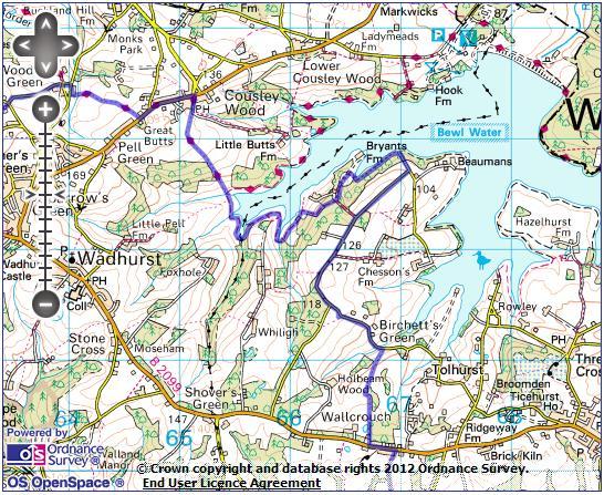
5 5 At the top of the long second field, you pass through the gate to the right, then swing round a tree-lined pond to continue uphill with the fence on your left towards the houses of Wallcrouch. At the top of the field, swing slightly right along fence and then head through a metal gate (no waymark) and through the next gate straight ahead to walk up Wallcrouch Farm's drive to the main road through the village. Head left, through the straggling village, past an ornamental stonemasons. Just beyond Pond Cottage on the right hand side, head right (there is a well-hidden concrete footpath sign) on a drive, immediately veering right on a grassy path between fences. The path descends gently through the fields, giving you the first brief glimpses of Bewl Water to the right. At the end of the fenced section, cross the stile and continue to follow the right hand fence to a gate. Cut across the corner of the small wood to the right to cross a stile. From here head right down the grassy field, paralleling the right hand boundary. You descend to a gateway, which leads into a further field. Continue to drop beside the fence to a gate and stile onto a minor road in the dell. Turn left along the road, which climbs quickly out of the stream valley past the scattered houses of Birchett Green. Just over the hill top you reach a road junction. Veer right on the dead-end Wards Lane (signed as 'Bewl Water Route'). The road curves round to run across hill-top fields. Dropping through a small wood, ignore the Bewl Water Route sign right and continue straight ahead. As the road descends, the main body of Bewl Water becomes visible, framed by the hedgerows. Sitting right on the border of Kent and Sussex, Bewl Water is the largest area of inland water in the south east of England. Completed in 1975 by the damming of the confluence of three small valleys, which form the River Bewl, the reservoir contains 31,300 million litres of water, which supplies the Medway Towns, Hastings and Kent more widely. Despite its relative youth, the reservoir has already blended well into the local scenery and has become a valuable habitat for wildfowl, some of which you will probably see on the lake. It is also popular for sailing and rowing. At a t-junction at the bottom of the hill, head left. Pass a barrier and descend steeply. This was once a through road to Lamberhurst but is now completely cut off by the reservoir. Immediately before the waters' edge, head left on a path through a small clearing beside the reservoir, with a little shelter in it. The path continues through woods beside the water along an inlet, before heading right and climbing to Bryants Farm Drive. Head left (signed to Wards Lane) up the drive. At the too of the hill you reach a small road. Turn right, but very soon head left, following Bewl Water Route signs along a broad path. After a few hundred metres of gentle descent, the path reaches the edge of a wood and turns right to drop steeply back to the water's edge. At the bottom of the hill, head left (signed as 'Round Bewl Water Walk'). The path continues beside the water, heading up an inlet then swinging round sharply at its head to return back up the opposite headland. Swing around the headland, the spire of Wadhurst church now visible above the trees on the hilltop.
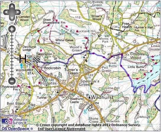
6 6 The path swings around a couple of further small inlets as it wanders through the woods at the western end of the reservoir. Ignore the path signed left to Wadhurst. Just beyond it, you cross a small stream, immediately after which you strike left across the grass to reach a stile. Cross the stile and follow a waymark uphill beside the hedgerow. Reaching the top of the steep second field, follow a footpath sign slightly left and then swing right up a slight bank into a large grassy field. Continue to climb gently beside the ditch. At the top of the hill, follow the waymark right onto a gently descending track (there is one final fine panorama of Bewl Water from here). At the bottom of the dip you join a small road at a corner. Keep straight ahead and head up the hill to the main road in the village of Cousley Wood, by the attractive Old Vine inn. Head left along the pavement past the inn. Continue through the village and past the junction with Monks Lane. About 100m beyond the junction, just past a house called Sadlers, cross and pass through a footgate opposite (marked as Sussex Border Path). Follow the broad path through a young deciduous plantation. Beyond, you cross a stile and follow the fenced path around a field edge. A further stile and then a kissing gate lead you onto a path descending beside a track towards the jumbled cluster of houses at Wood's Green. At the bottom of the hill, pass through a gate onto the drive of a half-timbered house and onto the road by the rather bumpy green. Head right and at the junction, turn left on Woods Green. The road climbs past houses and then through fields to a junction at the hilltop. Turn left towards Turners Green but almost immediately follow a footpath sign over a stile to the right. Keep to the clear path beside the left hand fence through the woodland, soon descending steadily. Having passed a scrap of heathland you eventually emerge on a minor road by a white cottage. Head right and at the junction right again towards Wadhurst station. Continue on this quiet, meandering road for just over 1km. The road descends gradually, before swinging left by the drive to grand Tappington Farm and then climbing briefly to a junction with the busy B2099. Swing sharp left here, having crossed with care. After about 50m you can head right up to Wadhurst's fine little station house. Cross the footbridge for London-bound trains. Wadhurst station, at a little over 100m above sea level, is the highest station in south east England. It was when Wadhurst tunnel collapsed that the Southeastern railway realised their contractors had lined the tunnels with just four layers of bricks rather than six. Adding the additional layers made the tunnels narrow and required the use of special narrow-profile trains for this line for many years, until most of the tunnels on the route were converted to single-track in the 1980s.
Medway Valley Orchards
 1 Medway Valley Orchards East Farleigh station - Kettle Corner - Farleigh Green - Buston Manor - Yalding - Yalding station Length: 6 ¾ miles (10.9km) Underfoot: Generally, this is a walk on good paths,
Gomshall station - Abinger Hammer - Abinger Common - Friday Street - Leith Hill - Coldharbour - Holmwood station
 1 To Leith Hill Gomshall station - Abinger Hammer - Abinger Common - Friday Street - Leith Hill - Coldharbour - Holmwood station Important note: this walk cannot currently be done wholly by train on a
Gomshall station - Abinger Hammer - Abinger Common - Friday Street - Leith Hill - Coldharbour - Holmwood station
 1 To Leith Hill Gomshall station - Abinger Hammer - Abinger Common - Friday Street - Leith Hill - Coldharbour - Holmwood station Important note: this walk cannot currently be done on a Sunday due to the
Chevening and the North Downs
 1 Chevening and the North Downs Dunton Green station - Chipstead - Chevening - Knockholt - Hawley's Corner - Botley Hill - Oxted station Length: 12 ¼ miles (19.7 km) Underfoot: Portions of the walk are
The Mendip Way. Route Directions and Maps Uphill to Wells
 The Mendip Way Route Directions and Maps Uphill to Wells Website: www.mendiphillsaonb.org.uk Email: mendip@mendiphillsaonb.org.uk Facebook & Twitter: @MendipHillsAONB Phone: 01761462338 1 Uphill to Loxton
Hadleigh Castle and Chalkwell Oaze
 1 Hadleigh Castle and Chalkwell Oaze Benfleet station Hadleigh Park Hadleigh Castle Leigh-on-Sea Chalkwell station A short stroll through the lush woods of Hadleigh Park high above the Thames-side marshes,
Ardingly Lake, Ouse Valley, Borde Hill
 point your feet on a new path Ardingly Lake, Ouse Valley, Borde Hill Distance: 14 km=9 miles or 12½ km=8 miles Region: West Sussex Author: Hautboy Refreshments: Borde Hill Map: Explorer 135 (Ashdown Forest)
Cuxton, Ranscombe and Cobham
 1 Cuxton, Ranscombe and Cobham Cuxton station - Ranscombe - Cobham Park - Cobham - Sole Street station Length: 5 ¾ miles (9.4 km) Underfoot: Most of this walk is on well-made paths or tracks, with a few
CWMGIEDD FROM ABERCRAVE
 Abercrave to Cwmgiedd Walk Page 1 Starting from The Abercrave Inn. Grid Ref: SN 824128 From the Abercrave Inn, an 11.3km (7 miles) walk to the foothills of the Cribarth Mountain, then through forest to
Leaden Boot Challenge ROUTE INSTRUCTIONS
 Leaden Boot Challenge ROUTE INSTRUCTIONS Section 1 Alstonefield to Ilam From the village hall car park turn R then L and pass through the village keeping to the R to enter Church Street. Pass the Church
Leaden Boot Challenge 2016 ROUTE INSTRUCTIONS
 Leaden Boot Challenge 2016 ROUTE INSTRUCTIONS Section 1 Alstonefield to Ilam (CP2) From the village hall car park turn R then L and pass through the village keeping to the R to enter Church Street. Pass
Beautiful Walks from the Blue Ball Inn
 Walk No. 5 RIVER VALLEYS AND MOOR Countisbury, Watersmeet, Hillsford Bridge, Cheriton, Shilstone Hill, Rockford and Chiselcombe. 8.5 MILES APPROX. Walking time four and a half hours approx. OS 1;25,000
Bentley station - Alice Holt Forest - Frensham Great Pond - Rushmoor - Pitch Place - Gibbet Hill - Haslemere station
 1 Devil s Punch Bowl and Surrey Heaths Bentley station - Alice Holt Forest - Frensham Great Pond - Rushmoor - Pitch Place - Gibbet Hill - Haslemere station Length: 13 ¾ miles (22.0 km) Underfoot: Almost
Mapledurham, Gallowstree and Shepherd s Green
 Mapledurham, Gallowstree and Shepherd s Green Pangbourne station Mapledurham Gallowstree Common Satwell Shepherd s Green Grey s Court Henley-on-Thames Length: 15 ½ miles (24.8km) Underfoot: Minor roads
Walk 1. Cotswold Water Park. Gateway Centre to Cerney Wick, railway track to Lake 6, Gateway Centre.
 Cotswold Water ark Walk way A Swindon/ Cirencester Thomas and Severn Canal way to Cerney Wick, railway track to Lake, way. Spine Road East Hotel Time: hours (short walk km) Distance: km A level walk along
Pontfadog. Walk A. Walk A
 Walk A A Bird s eye view of the village 2km. (1 1 /2 miles); height gain 45m. (150ft) about 45 minutes. Six minutes walk along the main road towards Glyn Ceiriog reach a signpost to Llwynmawr. Take the
Hindhead, Keffolds Copse and Gibbet Hill
 point your feet on a new path, Keffolds Copse and Gibbet Hill Distance: 6 km=4 miles Region: Surrey Author: Schwebefuss Refreshments: Punch Bowl Café moderate walking Date written: 14-apr-2015 Last update:
Baggy Point, Croyde, North Devon
 Baggy Point, Croyde, North Devon A walk using the South West Coast Path that is likely to be suitable for people with impaired mobility or with a pushchair, wheelchair, or mobility scooter. The Coast Path
BURGHCLERE PARISH RIGHTS OF WAY
 BURGHCLERE PARISH RIGHTS OF WAY Full descriptions compiled by Neill & Miggie Bruce All photos Miggie Bruce FP23 on Ridgemoor, looking south, with FP22 crossing by the bush FP1. From C183 Aldern Bridge
GRINDLEFORD GALLOP 2018
 GRINDLEFORD GALLOP 2018 Route Information The Grindleford Gallop follows a fixed 21 mile route through the lanes and paths of Derbyshire. All competitors must follow this route. An OS map of the area with
START - UPHILL BEACH. (tidal!) The West Mendip Way is route-marked with these round blue signs
 The West Mendip Way is route-marked with these round blue signs") START - UPHILL BEACH Start Times: 10:30 11:15 12:00 Please allow sufficient time to check in with the marshals Start on the beach at the high water line (tidal!) The West Mendip Way is route-marked with
START - UPHILL BEACH Start Times: 10:30 11:15 12:00 Please allow sufficient time to check in with the marshals Start on the beach at the high water line (tidal!) The West Mendip Way is route-marked with
Ivinghoe Beacon and the Grand Union
 1 Ivinghoe Beacon and the Grand Union Cheddington station - Horton Wharf - Ivinghoe - Ivinghoe Beacon - Bridgewater Monument - Aldbury - Tring station Length: 11 ¼ miles (18.3km) Underfoot: The first mile
Slad over to Pitchcombe and back
 The walk climbs up from Slad over Wickridge Hill, descends to near Pitchcombe, then climbs back over Wickridge hill and round the back of Slad. Page 1 Start Point: SO 8718 0732 The Woolpack, Slad Length:
Chess & Gade. Chalfont & Latimer Station - Latimer - Chenies - Sarratt - Kings Langley Station. Length: 8 ¾ miles (14.25km)
") 1 Chess & Gade Chalfont & Latimer Station - Latimer - Chenies - Sarratt - Kings Langley Station Length: 8 ¾ miles (14.25km) Underfoot: Well-trodden paths, mainly firm in all weather conditions, though
1 Chess & Gade Chalfont & Latimer Station - Latimer - Chenies - Sarratt - Kings Langley Station Length: 8 ¾ miles (14.25km) Underfoot: Well-trodden paths, mainly firm in all weather conditions, though
Ystwyth and Rheidol Bridleway Routes. Route 2:Llanilar Circular
 Ystwyth and Rheidol Bridleway Routes Route 2:Llanilar Circular Route overview and terrain: A long circle using connecting ridges with fine views to link the Rheidol and Ystwyth river valleys. The route
Singleton and the South Downs
 point your feet on a new path Singleton and the South Downs Distance: 13½ km=8½ miles easy walking with a few steeper sections Region: West Sussex Author: Hautboy Refreshments: Singleton, Hill Barn Date
BISHOPSTONE CIRCULAR WALK
 BISHOPSTONE CIRCULAR WALK 4½ miles (7¼ km) - allow 2 hours (see maps on final pages) Introduction This walk is within the North Wessex Downs Area of Outstanding Natural Beauty and starts from the small,
ID: 283 Distance: 6.2 miles Height gain: 500 Metres Map: Explore OL 19 Contributor David and Chris Stewart
 Walkingworld Wild Boar Fell ID: 283 Distance: 6.2 miles Height gain: 500 Metres Map: Explore OL 19 Contributor David and Chris Stewart Features Birds, Great Views, Hills or Fells Description: Wild Boar
Sponsored by. statestreet.com
 /STATESTREETISLANDWALK #ISLANDWALKJSY Sponsored by statestreet.com Important Information If you forget everything else PLEASE remember the following.» Remember to check OUT of every checkpoint» If you
HARDMOORS 55 RACE ROUTE 2018 HELMSLEY - GUISBOROUGH
 HARDMOORS 55 RACE ROUTE 2018 HELMSLEY - GUISBOROUGH HELMSLEY - CHECKPOINT 1 (WHITE HORSE) 1. Leave RACE START, continue ahead on road (Baxtons Sprunt) At crossroads turn right down Canons Garth eventualy
HARDMOORS ROUTE DESCRIPTION
 HARDMOORS 60 2016 ROUTE DESCRIPTION RACE START (GUISBOROUGH) - CHECKPOINT 2 (SALTBURN) DISTANCE 9 MILES CUT OFF TIME 1030 GRID REF OS 666 208 1. Leaving the Sea Cadets Hall, turn left onto the road and
Friday Street, Leith Hill, Holmbury Hill
 point your feet on a new path Friday Street, Leith Hill, Hill Distance: 12 km=7 miles easy-to-moderate walking + optional tour of Hill: 1½ km=1 mile Date written: 27-oct-2011 Region: Surrey Author: Schwebefuss
Britain s oldest surviving water-balanced cliff lift
 44 3.6 Saltburn by the Sea to Sandsend Map panels 3 and 4 Distance 17 miles (27½ km) Terrain mostly grass and field paths which can be muddy; some pavement, beach and shore Grade undulating route, with
Ranmore Common and Polesden Lacey
 point your feet on a new path Ranmore Common and Polesden Lacey Distance: 9½ km=6 miles Region: Surrey Author: Fusszweig Refreshments: Polesden Lacey easy walking Date written: 20-dec-2016 Last update:
The Hundred Parishes
 The Hundred Parishes Walks from railway stations number 3 3 miles (5kms) circular walk from Stansted Mountfitchet Start & finish: Stansted Mountfitchet station. Ordnance Survey Explorer Map 195. Grid Reference:
The Sudbury Branch Walks 1-4
 The Sudbury Branch Walks 1-4 Sudbury Branch Walks From Sudbury to Marks Tey The gentle declivities, the luxuriant meadow flats sprinkled with flocks and herds... the sound of water escaping from the mill
Hay Wood, Rowington and Baddesley Clinton - Warwickshire
 Hay Wood, Rowington and Baddesley Clinton - Warwickshire Starts at Lay-by alongside Hay Wood 2 hours 30 minutes 5.5miles 8.8km Leisurely ID: 0.683 Developed by: John Clift Checked by: Andy Page www.ramblersroutes.org
Beautiful Walks from the Blue Ball Inn
 Walk No. 2 WINSTONS WALK Countisbury, Wind Hill, Watersmeet, Ash Bridge and Winston s path. 5 Miles approx. Walking time- Two and a half hours approx. (Not including Breaks) OS 1:25,000 Sheet 64/74 Lynton
Bentley and Isington Mill Lower Froyle: The Anchor
 point your feet on a new path and Isington Mill Lower Froyle: The Anchor Distance: 12 km=7 miles Region: Hampshire Author: Botafuego Refreshments: Lower Froyle, easy walking Date written: 6-may-2012 Date
Penn Common and Bramshaw Wood
 Trail Activity Type Terrain Author Distance Ascent Location : HAMPTR0025 : Walk : Pub : Towpaths and Cycle Tracks : Anne-Marie Edwards : 5.3 miles / 8.5 kms : 381 feet / 116 metres : SU253173 / SP5 2BZ
COSTA BLANCA MOUNTAIN WALKERS - WALK DESCRIPTION. Visit for more walks descriptions in Spain
 Visit www.walksinspain.org for more walks descriptions in Spain Walk description originally prepared by:- Ralph Phipps Last Updated 15 th July 2016 Title of Walk Location of Start (include name of nearest
Self-Guided Walk Langdale Pikes. Start & Finish: NT car park (free to members) at Sticklebarn - on the right just beyond the New Dungeon Ghyll hotel.
 at Sticklebarn - on the right just beyond the New Dungeon Ghyll hotel.") Self-Guided Walk Langdale Pikes Key Information These mountains form a collection of spires and cliffs on the north side of Langdale. This walk visits four of the main tops Pavey Ark, Harrison Stickle,
Self-Guided Walk Langdale Pikes Key Information These mountains form a collection of spires and cliffs on the north side of Langdale. This walk visits four of the main tops Pavey Ark, Harrison Stickle,
Lewes and the South Downs
 point your feet on a new path and the South Downs Distance: 0 km=1½ miles moderate walking with long easy stretches Region: East Sussex Author: Hautboy Refreshments: Date written: 8-apr-013 Map: Explorer
3.1 Bowness-on-Solway to Carlisle
 3.1 Bowness-on-Solway to Carlisle Map panel 1 Distance 15 miles (24 km) Terrain minor roads, tracks, field paths and riverside footpath, muddy in places Grade easy, with gentle gradients on undulating
Merritts Traverse. 1928m
 Merritts Traverse 3 hrs Hard track 5.8 km Circuit 4 167m This walk starts with a scenic journey to the top of the hill on the chairlift. Starting along Merritts Nature walk, this walk soon detours down
Congewai Track Head (East) to Watagan Headquarters
 to Watagan Headquarters") Congewai Track Head (East) to Watagan Headquarters 7 hrs Hard track 17.2 km One way 4 973m This full day walk starts from the Congewai valley trackhead (east) and follows the Great North Walk up into the
Congewai Track Head (East) to Watagan Headquarters 7 hrs Hard track 17.2 km One way 4 973m This full day walk starts from the Congewai valley trackhead (east) and follows the Great North Walk up into the
This path goes past an old tree nursery and sawmill. After 800m it crosses over a lane. Follow the bridleway fingerpost into the woods.
 FRENSHAM PONDS 11K CIRCULAR TRAIL 2½ HRS GU10 2DA This magnificent heathland trail starts in woodland and then brings you out onto the open heather of Frensham Common, with no roadwork! The route runs
Fetcham Downs and Bocketts Farm A magical teashop walk
 point your feet on a new path Fetcham Downs and Bocketts Farm A magical teashop walk Distance: 3 km=2 miles or 4 km=2½ miles Region: Surrey Author: Fusszweig Refreshments: Bocketts Farm easy walking Date
Reigate Hill and Gatton Park
 point your feet on a new path Reigate Hill and Gatton Park Distance: 11½ km=7 miles easy-to-moderate walking or 2 walks of 6½ km=4 miles and 5½ km=3½ miles Region: Surrey Author: Schwebefuss Refreshments:
H U D S O N P A L I S A D E S
 14 H U D S O N P A L I S A D E S Hudson Palisades The southernmost sections of the Long Path follow the Hudson River and the Hudson Palisades north, staying close to the river and to civilization. Although
beach. Make the ford and follow the trail out to the junction with Red Creek Tr in an open grassy area.
 Description: This is a moderate to slightly strenuous 22.8 mile backpack (add 2.6 miles if you do the packless out and back to the Lion s Head) that will have you exploring nearly every thing that is The
Mt Kuring-gai Track to Berowra station
 Mt Kuring-gai Track to Berowra station 4 hrs 15 mins 9.7 km One way Hard track 4 553m This walk explores three valleys, with great displays of wild flowers in spring, and some nice sandstone overhangs.
Skiing and Snowshoes on Un-groomed Fernan Saddle Terrain
 Skiing and Snowshoes on Un-groomed Fernan Saddle Terrain Three ski or snowshoe routes are available from the Fernan Saddle Parking Lot which either do not cover routes ordinarily groomed for snow machine
Brightling, Dudwell Valley, Bateman s Forests and Follies
 point your feet on a new path Brightling, Dudwell Valley, Bateman s Forests and Follies Distance: 15 km=9½ miles Region: East Sussex Author: Stivaletti Refreshments: Woods Corner, Burwash Weald moderate
Staples Lookout to Mt Wondabyne loop
 Staples Lookout to Mt Wondabyne loop 4 hrs 3 mins 1.8 km Circuit Hard track 337m This walk starts and finishes at Staples Lookout, on Woy Woy Rd. The walk follows sections of the Great North Walk around
Aeron & Arth walks 4 walks for all the family to enjoy
 Aeron & Arth walks walks for all the family to enjoy Please take note that the maps illustrating these walks are intended as a rough guide only. You should use the most recent version of the relevant Ordnance
The 34 th Poppyline Marathon
 The 34 th Poppyline Marathon Saturday 9th June 2018 - Route Description Emergency number: 07906 404673 or 07597 052572 Ahd - Ahead BL - bear left BR - bear right BW - bridleway Cont - continue FB - footbridge
Self-Guided Walk Malham, Gordale and Malham Tarn
 Self-Guided Walk Malham, Gordale and Malham Tarn Combine all the major geological attractions of Malham in this walk and hopefully leave enough time to enjoy the cafes, pubs and shops of the village. Malham
A Tour of the Valle del Gizio
 Walk 25 A Tour of the Valle del Gizio Walking time 5hrs 30mins (4hrs if Colle Mitra is omitted) Difficulty 2 (likely to be snowbound in winter months); 1 (if Colle Mitra is omitted) Ascent/descent 570m/570m
Walk 1: Highfield, Lob Wood and The River Wharfe
 Walk 1: Highfield, Lob Wood and The River Wharfe Start: The Hen Pen Garden, Main Street, Addingham LS29 0NS, SE 077 498. Alternative Start: Near Bolton Bridge SE 071 525 (see page 6). Full walk: 4.5 miles
Leura Cascades to Gordon Falls Reserve
 Leura Cascades to Gordon Falls Reserve 1 hr 15 mins 1.8 km One way Moderate track 200m From Leura Park to Gordon Falls Park, this diverse walk offers fantastic views of the Jamison Valley, as well as two
Orchards and oasts a taste of the Garden of England
 49 Orchards and oasts a taste of the Garden of England Open parkland, orchards, oasts and incredible panoramic views over the Weald to the South Downs make this a truly memorable walk. Linton Village 50
CELEBRATE WEST GREENWICH GEOCACHING THROUGHOUT WEST GREENWICH
 CELEBRATE WEST GREENWICH GEOCACHING THROUGHOUT WEST GREENWICH The West Greenwich Land Trust (WGLT) is sponsoring Celebrate West Greenwich, an event designed to celebrate the beauty and history of scenic
MOTTYNSDEN MANOR BURWASH EAST SUSSEX
 MOTTYNSDEN MANOR BURWASH EAST SUSSEX MOTTYNSDEN MANOR SPRING LANE BURWASH EAST SUSSEX TN19 7HX Burwash 1.1 miles; Etchingham Station (London Bridge from 1hr 10 mins) 3.7 miles; Tunbridge Wells 13.8 miles;
River Isla B951. Diarmid s Tomb
 3. 4 Spittal of Glenshee to Kirkton of Glenisla Distance 14.6 miles 23.5 km Terrain mainly on rough moorland path with boggy bits and stream crossings, then heading east along at the B951 for 2.5 miles,
A Circular Walk from Chapel Carn Brea
 A Circular Walk from Chapel Carn Brea 4.3 Miles A Walk Visiting Five Historic Ancient Sites This circular walk offers the possibility of several alternatives, depending on the walker s available time and
The Bridestone Rocks from Lydgate
 Print this page Back to results The Bridestone Rocks from Lydgate Ancient tracks and gritstone outcrops, with terrific views of the steepsided Cliviger Valley. Distance 5 miles (8km) Minimum time 2hrs
Description for the Round Rotherham 8 December 2007
 Directions: L left R right ½L, ½R half left, half right X cross X Rds cross roads SA straight Codes: BR bridge FP footpath FB footbridge RWY railway CP car park RD road Description for the Leave Event
Rogue Gorge (Mt. Stella) Roadless Area-- T30S R3E (primarily in portions of Sections 23, 26, 33, 34 & 35)
 Roadless Area-- T30S R3E (primarily in portions of Sections 23, 26, 33, 34 & 35)") Rogue Gorge (Mt. Stella) Roadless Area-- T30S R3E (primarily in portions of Sections 23, 26, 33, 34 & 35) Rogue River-Siskiyou National Forest--High Cascades Ranger District Upper, higher elevation trail
Rogue Gorge (Mt. Stella) Roadless Area-- T30S R3E (primarily in portions of Sections 23, 26, 33, 34 & 35) Rogue River-Siskiyou National Forest--High Cascades Ranger District Upper, higher elevation trail
Beamers Trail. Walk No.1. 6 miles. (easy with some moderate ascents and descents)
") Beamers Trail Walk No.1 6 miles (easy with some moderate ascents and descents) 1 BEAMERS TRAIL 6 miles (easy with som WALK The Warpers Trail forms part of the long distance Witton Weavers Way. This is
Beamers Trail Walk No.1 6 miles (easy with some moderate ascents and descents) 1 BEAMERS TRAIL 6 miles (easy with som WALK The Warpers Trail forms part of the long distance Witton Weavers Way. This is
Victoria Falls and Grose Valley to Blackheath Station
 This walk explores a fantastic section of the Grose Valley. Starting above Victoria Falls, the walk explores the cascades before dropping into the valley for the first nights rest at Burra Korain campsite.
Western Commission Track to Dubbo Gully
 This two day walk follows a series of historic roads along clear and wide management trails. This walk explores the great views from Western Commission Track, the sandstone handicraft on the Old Great
Tour Of Tameside The alternative tameside trail
 Tour Of Tameside The alternative tameside trail A 30 mile walk around the borough of Tameside taking in the Valleys of the Medlock, Etherow and Tame. The whole walk can be completed in one day by anyone
Freefolk and Whitchurch
 Trail Activity Type Terrain Author Distance Ascent Location : HAMPTR0026 : Walk : Tea Shop : Towpaths and Cycle Tracks : Jean Patefield : 5.6 miles / 9 kms : 377 feet / 115 metres : SU487488 / RG28 7NN
Scenic Railway to Ruined Castle
 Scenic Railway to Ruined Castle 7 hrs 30 mins 12.4 km Return Hard track 4 963m This is a very popular, full day walk, in the Katoomba Area, offering great views of the valley. The walk follows the edge
Girrakool to Wondabyne station
 Girrakool to Wondabyne station 4 hrs Hard track 9.5 km One way 4 438m This walk starts from the Girrakool picnic area and winds south, through the Brisbane Waters National Park. The walk crosses some long
Wondabyne station to Somersby Store
 Wondabyne station to Somersby Store 10 hrs Hard track 26.2 km One way 4 1164m This walk, following a section of the Great North Walk, starts from the Wondabyne train station and winds north, into the Brisbane
Jerusalem Bay Track (Cowan to Brooklyn)
") Jerusalem Bay Track (Cowan to Brooklyn) 5 hrs 30 mins 13.4 km One way Hard track 4 654m This Cowan to Brooklyn Station walk is a popular section of the Great North Walk, with scenery ranging from foreshore
Jerusalem Bay Track (Cowan to Brooklyn) 5 hrs 30 mins 13.4 km One way Hard track 4 654m This Cowan to Brooklyn Station walk is a popular section of the Great North Walk, with scenery ranging from foreshore
A travel description of the Brisbane Airport Domestic Terminal Precinct. Author: Mr Terry Boyle of the Tactual Mapping Committee (September 2013)
") A travel description of the Brisbane Airport Domestic Terminal Precinct Author: Mr Terry Boyle of the Tactual Mapping Committee (September 2013) Brisbane Airport is located approximately 18 kilometres
A travel description of the Brisbane Airport Domestic Terminal Precinct Author: Mr Terry Boyle of the Tactual Mapping Committee (September 2013) Brisbane Airport is located approximately 18 kilometres
S H A W A N G U N K R I D G E T R A I L
 214 Shawangunk Ridge Trail The Shawangunk Ridge Trail was originally conceived as a relocation of the Long Path from Harriman State Park to Minnewaska State Park. Now part of the Long Path system, the
Tacklers Trail. Walk No miles. (A walk with a couple of short steep slopes and some rough moorland paths)
") Tacklers Trail Walk No.3 9.5 miles (A walk with a couple of short steep slopes and some rough moorland paths) WALK 3 TACKLERS TRAIL 9.5 miles (moderate wi 1. Sunnyhurst Visitor Centre The Warpers Trail
Tacklers Trail Walk No.3 9.5 miles (A walk with a couple of short steep slopes and some rough moorland paths) WALK 3 TACKLERS TRAIL 9.5 miles (moderate wi 1. Sunnyhurst Visitor Centre The Warpers Trail
Patonga to Staples Lookout
 Patonga to Staples Lookout 6 hrs 3 mins 17 km One way Hard track 4 72m This great walk explores much of the main ridge ridge running through Brisbane Water National Park. The walk visits a number of great
Warpers Trail. Walk No miles. (Easy with a few, short steep ascents)
") Warpers Trail Walk No.4 8.5 miles (Easy with a few, short steep ascents) 4 WARPERS TRAIL 8.5 miles (easy with a WALK The Warpers Trail forms part of the long distance Witton Weavers Way. This walk combines
Warpers Trail Walk No.4 8.5 miles (Easy with a few, short steep ascents) 4 WARPERS TRAIL 8.5 miles (easy with a WALK The Warpers Trail forms part of the long distance Witton Weavers Way. This walk combines
Black Hill Regional Park, Little Seneca Lake
 Black Hill Regional Park, ittle Seneca ake ittle Seneca ake, in Black Hill Regional Park, is a reservoir created after a previous drought struck the Washington area. The park is under Maryland-National
Thames Estuary Path Hoo Peninsula and Medway Estuary Overview
 Thames Estuary Path Hoo Peninsula and Medway Estuary Overview The Medway Estuary is outside the scope of this study, which concentrates on the Thames waterfront up to Grain Power Station and the north
Approximate distance: 7.5 miles For this walk we ve included OS grid references should you wish to use them.
 Approximate distance: 7.5 miles For this walk we ve included OS grid references should you wish to use them. 6 5 7 8 4 1 2 Start End N 3 W E S Reproduced by permission of Ordnance Survey on behalf of HMSO.
Delamere Loop. The. Useful Businesses Equestrian Escapes Tailor-made horse riding holidays in Cheshire. Tel:
 The Loop Accommodation Providers Akesmere Bed & Breakfast OS Grid Ref. SJ589/669 B&B for horse and rider. Chester Road, Little, Tarporley, Cheshire CW6 9ER Tel: 01829 760348 www.akesmerefarm.co.uk Useful
river point your feet on a new path
 river point your feet on a new path Frensham and Bourne Wood Distance: 13 km=8 miles or 11 km=7 miles easy walking with a few steep gradients Region: Surrey Author: Schwebefuss Refreshments: Shortfield
Erskine Creek via Pisgah Rock and Jack Evans
 Erskine Creek via Pisgah Rock and Jack Evans 4 hrs 30 mins 7.1 km Circuit Very experienced only 6 421m This walk visits some great lookouts and explores the lower section of Erskine Creek. Most of the
Difficult Run Stream Valley Park
 Difficult Run Stream Valley Park The more intense mountain bikers have known about for Difficult Run for some time. Equestrians have known it longer. Eight miles of unpaved trail, the Rails to River Trail
Wicklow Mountains Path Survey
 Wicklow Mountains Path Survey Glenmacnass Tonelagee Start to Finish: O 114 030 to O 085 016 Altitude (lowest highest): 370m 817m Weather: Sunny day, hot Access: Military Road, Glenmacnass Surveyed by:
Girrakool to Wondabyne station via Pindar caves
 Girrakool to Wondabyne station via Pindar caves 7 hrs 30 mins 18.1 km One way Experienced only 5 741m This walk starts from the Girrakool picnic area and winds south, following Piles creek into the Brisbane
West Hoathly, Balcombe & Bluebell Railway Steam and Seed Bank
 point your feet on a new path West Hoathly, Balcombe & Bluebell Railway Steam and Seed Bank Distance: 8 km= miles or walks of 9½ km=6 miles and 0 km=6½ miles Region: West Sussex Author: Stivaletti Refreshments:
General Summer and Winter Views
 ENVIRONMENTAL INFORMATION REPORT VOLUME 4 APPENDIX 11. 2 General Summer and Winter Views Table of Contents Section APPENDIX 11.2 Page 1 General Views... 1-1 Tansy Lane, Portishead... 1-2 Galingale Way,
From the car park go through the wooden gate and walk to a large information board and wooden totem pole ahead of you.
 Trail Dave Price, Geograph (CCL) Twin peaks What are these striking wooded hills here in an otherwise flat landscape? Time: 40-60 mins Distance: 1 ¼ miles Landscape: rural Standing at over 300 feet tall
COSTA BLANCA MOUNTAIN WALKERS - WALK DESCRIPTION. Visit for more walks descriptions in Spain
 COSTA BLANCA MOUNTAIN WALKERS - WALK DESCRIPTION Visit www.walksinspain.org for more walks descriptions in Spain Walk description originally prepared by:- Ralph Phipps Last Updated 25th Sep 2015 Title
San Miguel to Caserio de la Hoya Circular (San Miguel)
") Tenerife Sur: Short Walks Under 10 km San Miguel to Caserio de la Hoya Circular (San Miguel) Route Summary An informative and scenic walk back in time from San Miguel to below El Roque, overlooking the
Tenerife Sur: Short Walks Under 10 km San Miguel to Caserio de la Hoya Circular (San Miguel) Route Summary An informative and scenic walk back in time from San Miguel to below El Roque, overlooking the
White Horse Trail Route directions (Clockwise) split into 10 section with an alternative for the Alton Barnes to Cherhill section
 split into 10 section with an alternative for the Alton Barnes to Cherhill section") White Horse Trail Route directions (Clockwise) split into 10 section with an alternative for the Alton Barnes to Cherhill section S1 White Horse Trail directions Westbury to Bulkington Maps: OS Explorer
White Horse Trail Route directions (Clockwise) split into 10 section with an alternative for the Alton Barnes to Cherhill section S1 White Horse Trail directions Westbury to Bulkington Maps: OS Explorer
SHEEPLEAS. Visitor Guide and Self-guided Trails
 SHEEPLEAS Visitor Guide and Self-guided Trails Sheepleas The Sheepleas is an interesting mix of woodland, scrub and open grassland, situated on the chalk of the North Downs. This diversity of habitats
Cowan to Wondabyne station via Patonga rest area
 Cowan to Wondabyne station via Patonga rest area 2 Days Hard track 33.4 km One way 4 1523m This section of the Great North Walk starts from Cowan train station and wanders past the majestic Jerusalem Bay