Proposed Peninsula Bay Bike Track Development
|
|
|
- Walter Wesley Johnston
- 5 years ago
- Views:
Transcription
1 Proposed Peninsula Bay Bike Track Development May 2018 BACKGROUND The area of land at the northern extreme of Wanaka's Peninsula Bay development (Lot 923 DP ), currently owned by Infinity Investment Group, is expected to be vested with council in May / June This follows the completion of the District Plan Change 51 process in early Bike Wanaka Inc, who submitted with regard to PC51 on behalf of the mountain bike community of Wanaka, have volunteered to coordinate the planning and development of new mountain bike tracks on the land to be vested with council. This fits with the intent of Bike Wanaka's strategic plan to develop MTB for all levels in our community.

2 THE AREA The area in question provides outstanding views over the lake and great opportunities to ride through open grass spaces interlinked with trails through natural kanuka stands. The area extends well into the area identified as ONL, it includes an open and elevated ridge top and a significant amount of natural vegetation. The area already has existing walking and biking tracks that feel remote and natural and are separated from the residential development of Peninsula Bay by the natural topography. The boundary of the urban development is at the base of a natural moderate slope. Tracks located further to the north, on the higher ground of this slope, would avoid proximity to the houses - ensuring privacy for residences and a pleasant experience for trail users. PERCEIVED COMMUNITY NEED The Bike Wanaka membership and committee have identified a number of biking needs that the wider community would enjoy. These needs could be well served by the area:
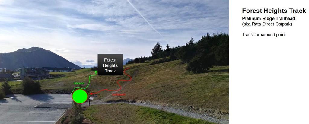
3 An easily accessible beginners cross country mountain bike track providing a mountain bike experience to all ability levels and ages. Currently, local and visiting mountain bike riders are limited to local riding that is either too steep and arduous (e.g. Sticky Forest) or too flat and busy with other users (e.g. The Outlet Track). Bike Wanaka sees a need to build an easily accessible and well signposted track that offers family, young and beginner riders an alternative. A MTB skills development area providing riders of all ability levels with a place to practice mountain bike skills in more gentle terrain than offered by Sticky Forest or Lismore Park. In addition, a need that is related to this area and could be considered at the same time is: An alternative to the existing "Scurr Heights" multi-use track - from Platinum Ridge carpark (off Forest Heights road) to Infinity Drive carpark. The current Scurr Heights Track is not a great experience for novice or young bikers due to it's steep and loose surface and poorly designed downhill sections. Additionally, the track, being multi-use and shared with walkers, runners and dogs can lead to dangerous encounters between fast riders and other users. Bike Wanaka has noted the mountain bike community's perception that the current Scurr Heights Track is not an attractive option for riding.
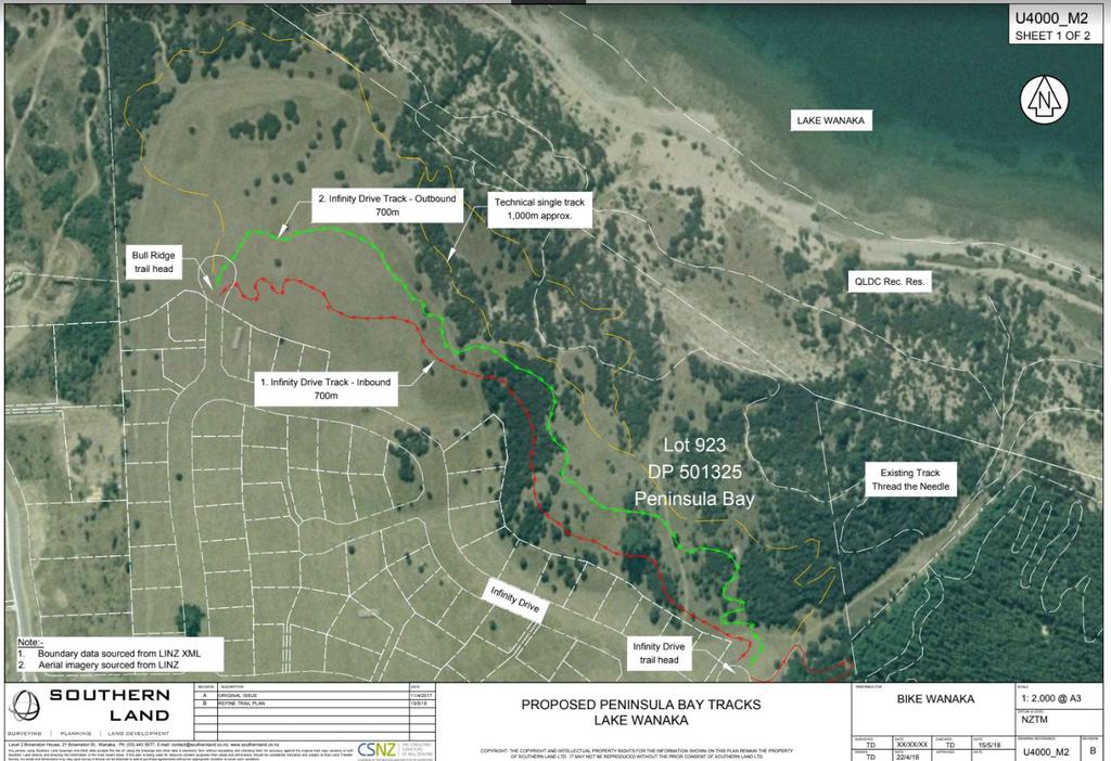
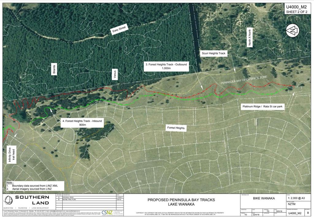
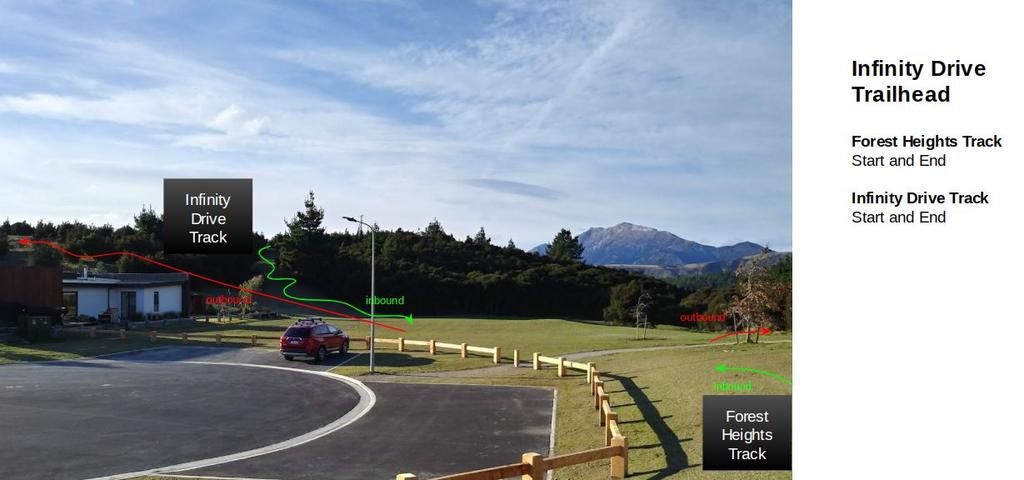
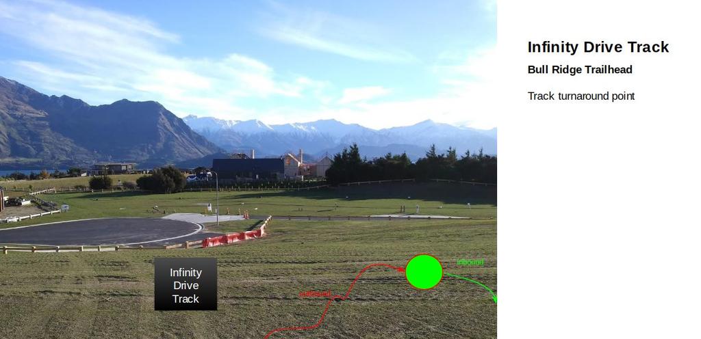
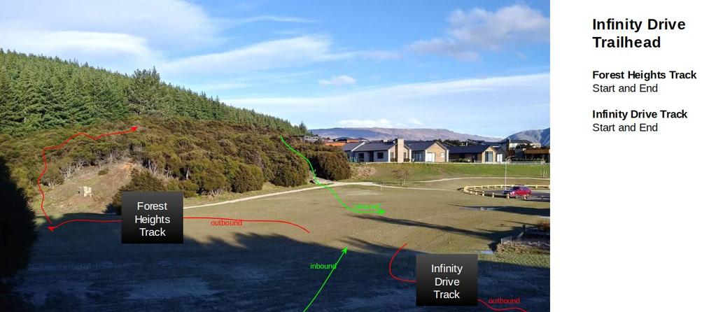
4 THE PROPOSED TRACKS Taking into account the land area that QLDC will soon control and Bike Wanaka's perceived community need, the following tracks are proposed: 1. Infinity Drive Track A 1.4km loop starting and finishing at the Infinity Drive Trailhead (carpark at eastern end of Infinity Drive). Track heads north west through both open areas of land and kanuka stands adjacent to the boundary with Infinity Drive. Track turns at Bull Ridge Trailhead (car park situated at northern end of Bull Ridge) and returns to south east behind skyline of ridge, again skirting through open areas of land and kanuka stands. Access to track will be from both trailheads, existing Infinity Drive access paths and existing walking paths in local area. The track will be a mm wide formation, using natural materials, some banked corners but mostly just gently cambered. Track will have a smooth surface, drainage features and family friendly. 2. Forest Heights Track A 1.4km loop, also starting and finishing at the Infinity Drive trailhead. Track heads south, initially up a gentle switch-backed climb within a large section of knauka between existing Scurr Heights track and the boundary with Sticky Forest. Track continues south keeping adjacent to Sticky Forest boundary until crossing Scurr Heights track at high point - crossing is placed at area of least speed for both tracks to mitigate risk of collision. Track then follows open land south to existing Platinum Ridge carpark. At carpark tracks returns to north and follows open country adjacent to boundary with Forest Heights properties. Access to the track will be from trailheads, Forest Heights access paths (x2) and Scurr Heights track. As before, track will be a mm wide formation, using natural materials, some banked corners but mostly just gently cambered. Smooth surface, drainage features and family friendly. 3. Skills Development Area After consideration of the need for a specific skills development area, the Bike Wanaka team have proposed instead to add skills development sections to the above tracks. Rationale being: 1. A single location would likely be too far from Wanaka's centre of population to be popular. 2. The tracks proposed above would become more appealing to a broader base of riders if skills sections were added. 3. Natural obstacles (such as logs, tree stumps and rocks) could be sympathetically incorporated into the track, better blending the obstacle into the surroundings.
5 4. Artificial obstacles (such as timber beams and ramps), which would necessary if building a stand-alone skills area could be be avoided, which better maintains the natural beauty of the area, and reduces maintenance needs. The proposed tracks are illustrated below:
6 TRACK PLANS (Draft May 2018)
7
8
9 TRACK CONCEPTUAL IMAGES


10 Link to virtual track walk
11 PLAN OF ACTION In order to secure approval and funding for these tracks the following plan of action has been discussed with Bike Wanaka committee on 7 May 18 Completed steps: 1. Initial Liaison with QLDC (Diana Mason) to brief of Bike Wanaka intentions (Completed Tim D 5 Apr) 2. Liaison with Infinity Investments to establish time frame for vesting with council (Completed Ian Greaves 16 Mar) 3. Definition of track needs (Completed - this Document - presented to BW committee on 4 Apr)) 4. Reconnaissance of track locations (Completed between 18 Apr - 1 May) Next Steps 5. Attend Wanaka Community Board workshop to brief QLDC and WCB (11am, 6 June 2018) 6. Prepare invitation for public consultation - provide public and local residents with the details of the proposed track plans, construction impact and timeframes - use combination of flyers, facebook posts and community message boards. Seek to catalogue and present feedback to public and QLDC to occur in June Prepare QLDC submission details to be confirmed in June Preparation of track building plan (to occur June 2018) Determination of track building team mix (volunteers / groups / commercial) Invitation to tender from commercial track building operations Costing of track building effort Liaison with QLDC on plans Application for grants / funding sources Ongoing track maintenance plan 9. Track building works (Aug - Sep 2018?) 10. Track commissioning work (Oct 2018?) including signage, maintenance handover, track map updates, opening event
12 NOTES ON COSTING / FUNDING For planning purposes, the track has been initially costed (May 2018) at $42,000 to construct using the following criteria: Assume full construction by commercial track building operator Considering land, obstacles, access for area Considering specifications for track Cost estimated at $15 per m (for 2800 m of track) Bike Wanaka historically has been able to secure amounts of volunteer labour, donations of time and material which would reduce this costing. This will be confirmed during costing phase. Bike Wanaka will also consider applications to the following funding organisations to assist with funding Trail Fund NZ Upper Clutha Link Community Fund Central Lakes Trust Otago Community Trust Lion Foundation Community Organisation Grants Scheme COGS
13 FURTHER QUESTIONS / CONTACT Tim David Bike Wanaka Tracks Project Coordinator timwdavid@gmail.com
Trail Phasing Plan. Note: Trails in the Clear Creek Canyon area (Segments will be finalized in the future to minimize wildlife impacts
 Note: Trails in the Clear Creek Canyon area (Segments 2 5 and a future JCOS connection) will be finalized in the future to minimize wildlife impacts Trail Phasing Plan P Parking 3 Easy Trail Intermediate
Baggy Point, Croyde, North Devon
 Baggy Point, Croyde, North Devon A walk using the South West Coast Path that is likely to be suitable for people with impaired mobility or with a pushchair, wheelchair, or mobility scooter. The Coast Path
MT ARTHUR CHALLENGE SPONSORSHIP PROSPECTUS.
 MT ARTHUR CHALLENGE Promoting physical fitness, the beautiful Mt Arthur Reserve and supporting the local community. SPONSORSHIP PROSPECTUS 2018 www.mtarthurchallenge.org.au EVENT INFORMATION The Mt Arthur
Recreation News. Welcome. Chris Jackson. In this Issue: O S U C o l l e ge F o r e s t s
 Recreation News O S U C o l l e ge F o r e s t s In this Issue: Welcome New tree identification posts... New Arboretum Trails New Interpretive Signs Ridge Trail Seasonal Closures Leave No Trace reminder
Mt. Hood National Forest
 United States Department of Agriculture Forest Service Mt. Hood National Forest Zigzag Ranger District 70220 E. Highway 26 Zigzag, OR 97049 503-622-3191 Fax: 503-622-5622 File Code: 1950-1 Date: June 29,
Wanaka Community Board 15 April Report for Agenda Item: 4
 Wanaka Community Board 15 April 2015 Department: Infrastructure Report for Agenda Item: 4 Mt Burke Station Stopping and Vesting of Road Purpose 1 To obtain the Board s support for a stakeholder agreement
FURTHER SUBMISSION BY THE BOARD OF AIRLINE REPRESENTATIVES OF NEW ZEALAND ON THE DRAFT QUEENSTOWN LAKES DISTRICT COUNCIL DRAFT PLAN
 FURTHER SUBMISSION BY THE BOARD OF AIRLINE REPRESENTATIVES OF NEW ZEALAND ON THE DRAFT QUEENSTOWN LAKES DISTRICT COUNCIL DRAFT PLAN BARNZ is an incorporated society comprising 20 member airlines operating
Port Gamble Shoreline Area Conceptual Trail Proposal
 The North Kitsap Trails Association is pleased to be a partner to the Kitsap Forest and Bay Project and assist Kitsap County, Forterra, Olympic Property Group, Great Peninsula Conservancy and the Port
Thank you for the opportunity to comment on the proposed action to add trails and trailheads to the Red Rock District trail system.
 July 14, 2010 Jennifer Burns Red Rock Ranger District PO Box 20429 Sedona, AZ 86341 Flagstaff Biking Organization PO Box 23851 Flagstaff, AZ 86002 Dear Jennifer- Thank you for the opportunity to comment
Stephens State Park Trails
 TRAILS OF ALLAMUCHY MOUNTAIN & STEPHENS STATE PARKS Allamuchy Mountain and Stephens State Parks contain 28 marked trails providing access to diverse landscapes for walking, hiking, biking, bird-watching,
Non-motorized Trail Plan & Proposal. August 8, 2014
 Town of Star Valley Ranch, Wyoming and the Star Valley Ranch Association in partnership with the USDA Forest Service, Bridger-Teton National Forest, Greys River Ranger District Non-motorized Trail Plan
Blueways: Rivers, lakes, or streams with public access for recreation that includes fishing, nature observation, and opportunities for boating.
 Parks, Open Space and Trails PRINCE WILLIAM COUNTY 2008 COMPREHENSIVE PLAN TRAILS PLAN CONTENTS The components of the trails plan are: Intent Definitions Goals, Policies, and Action Strategies Trails Map
Borough High Street Low Emission Neighbourhood
 Borough High Street Low Emission Neighbourhood Colourful Crossings Design Brief Better Bankside Business Improvement District Brief for Graphic Consultants December 2017 Page 1 of 10 1. Introduction Borough
A summary of Draft Makara Peak Mountain Bike Park Master Plan
 A summary of Draft Makara Peak Mountain Bike Park Master Plan OVEMBER 216 Image: Peter Marshall 2 3 Introduction Since it was established in 1998, the Makara Peak Mountain Bike Park (Makara Peak) has grown
GATEWAY PHASE 2. U.S. Forest Service and the Mount Shasta Trails Association
 GATEWAY PHASE 2 U.S. Forest Service and the Mount Shasta Trails Association PROJECT DEVELOPMENT Brief history - Gateway Phase 1 - IMBA conceptual plan - BikeShasta: concert series - USFS & MSTA partnered
Preferred Recreation Recommendations Stemilt-Squilchuck Recreation Plan March 2018
 Preferred Recreation Recommendations Stemilt-Squilchuck Recreation Plan March 2018 Below are the recommended recreation ideas and strategies that package together the various recreation concepts compiled
Interreg Vb /Prowad Link WP6.5. Feasibilitystudy, nature tourism routes around the North Sea Region Project description
 Interreg Vb, North Sea Region Prowad Link project Feasibility study: Nature tourism route around the North Sea Region, 2019 / specification 06.02.2019 Background Interreg Vb, North Sea Region, project
INVOC Abriachan Orienteering Local Event. Sunday 10 th March 2019
 INVOC Abriachan Orienteering Local Event Sunday 10 th March 2019 Planners comments For those that are new to Abriachan the terrain is technical but physical. From a technical side of things the open hill
CMC Member Guide to the CMC Website
 CMC Member Guide to the CMC Website HOW TO: Sign Up or Cancel a Trip/Event/Class Change Your Personal Information PLUS HOW TO FIND: Renew Your Membership Trip classification information Denver Group Classification
Trails Technical Committee
 Trails Technical Committee Winter 2017 Draft Report Alignment Proposals for the Inyo National Forest and the Town of Mammoth Lakes Map ID #S18 February 08, 2017 Map ID #S18 Key Agreements As of February
BEFORE THE HEARINGS PANEL FOR THE QUEENSTOWN LAKES PROPOSED DISTRICT PLAN AND
 BEFORE THE HEARINGS PANEL FOR THE QUEENSTOWN LAKES PROPOSED DISTRICT PLAN IN THE MATTER of the Resource Management Act 1991 AND IN THE MATTER of Hearing Stream 12 Upper Clutha Mapping Annotations and Rezoning
APPENDIX D: SUSTAINABLE TRAIL DESIGN. APPENDICES Town of Chili Parks and Recreation Master Plan Update
 APPENDIX D: SUSTAINABLE TRAIL DESIGN APPENDICES Town of Chili Parks and Recreation Master Plan Update Sustainable Trail Construction Sustainable trails are defined by the US Forest Service as trails having
Trail Assessment Report
 Trail Assessment Report Trail Options for the Bear Creek Canyon located in Pikes Peak Ranger District, Pike National Forest and on Colorado Springs Utility Lands Due to the presence of a unique species
Nov. 19 th Public Workshop Summary
 On November 19 th, more than 60 community members attended an Open Space Matters workshop at the Linen Building in downtown Boise for over two hours. Participants learned about reserves, discussed the
EAST DON TRAIL ENVIRONMENTAL ASSESSMENT. Community Liaison Committee Meeting #3 July 15, :30 to 8:30 pm Flemingdon Park Library
 EAST DON TRAIL ENVIRONMENTAL ASSESSMENT Community Liaison Committee Meeting #3 July 15, 2013 6:30 to 8:30 pm Flemingdon Park Library Agenda 1. Welcome 2. Housekeeping and Updates a) Housekeeping b) CLC
Response to Public Comments
 Appendix D Response to Public Comments Comment Letter # Response 1, 2, 3, 4, 5, 7, 8, 9, 10, 11, 12, 13, 14, 15, 16, 17, 18, 19, 20, 22, 23, 24, 25, 26, 27, 29, 30, 31, 32, 33, 34, 35, 36, 37, 38, 39,
Section II. Planning & Public Process Planning for the Baker/Carver Regional Trail began in 2010 as a City of Minnetrista initiative.
 Section II Planning & Public Process Planning for the began in 2010 as a City of initiative. city staff began discussions with the Park District on the possibility of a north/south regional trail connection
Citrus Heights Creek Corridor Trail Project Trail Advisory Group Field Trip #2 September 11, :00 11:00 am Trellis Hall, Citrus Heights
 September 11, 2013 9:00 11:00 am Trellis Hall, Citrus Heights Project Overview The City of Citrus Heights is studying the feasibility of establishing a multi use trail system within the City s 26 miles
IOW Ramblers Submission Paper to the Sept 2016 ROW Improvement Plan Consultation.
 IOW Ramblers Submission Paper to the Sept 2016 ROW Improvement Plan Consultation. The current Island Rights of Way Improvement Plan is a comprehensive document and much of its content is still relevant
Loop Walks Key Criteria
 Loop Walks Key Criteria 1/31/2012 CONTENTS Mission... 3 Background... 3 Phase 1... 3 Guidelines... 3 Occasional Walker... 5 Level of Difficulty... 5 Loop Furniture... 6 1. Mapboard... 6 2. Waymarkers...
Tullibody Action Group Vision for New Civic Centre
 Tullibody Action Group Vision for New Civic Centre August 2017 Prepared by Sandra Macaskill, Caskieco, M 07986 163002 E Caskieco@aol.com CaskieCo 1 1. Introduction 1.1. Tullibody Action Group (TAG) came
Table of Contents. page 3 Long term Goals Project Scope Project History. 4 User Groups Defined Trail Representative Committee. 5 Trail Users Breakdown
 Launched April 27th, 2010 1 Table of Contents page 3 Long term Goals Project Scope Project History 4 User Groups Defined Trail Representative Committee 5 Trail Users Breakdown 13 Trail Users Desires 16
Understanding user expectations And planning for long term sustainability 1
 Understanding user expectations And planning for long term sustainability 1 What is a natural surface trail? It can be as simple has a mineral soil, mulched or graveled pathway, or as developed as elevated
1. Study the Ordnance Survey Map of Brodick, Isle of Arran.
 1. Study the Ordnance Survey Map of Brodick, Isle of Arran. To find the map go to: > http://www.bing.com/maps/ > change maps type to Ordnance Survey Map from Road. > search for Glenrosa Water (it is near
Welcome and thank you for being here! Kick-Off Public Workshop November 19, 2014
 Welcome and thank you for being here! Kick-Off Public Workshop November 19, 2014 OPEN SPACE MATTERS: Boise s First Reserve Master Plan Julia Grant Foothills and Open Space Manager City of Boise Ellen Campfield
Coast to Crest Trail Corridor Hike
 Coast to Crest Trail Corridor Hike Jim Cunningham, Poway City Council member and Board Chair of the San Dieguito River Park in 2013 has embarked on a project to hike the entire 70-mile San Dieguito River
APPENDIX 5: JUNEAU NORDIC SKI CLUB MEMO
 APPENDIX 5: JUNEAU NORDIC SKI CLUB MEMO To all participants in the McDowell Eaglecrest nordic long-range planning meeting: It was good to meet with all of you last month and talk about our vision for the
DATE: 23 March, 2011 TO: Communities FROM: BlazeSports America. RE: Accessible Trails Checklist 1
 M E M O R A N D U M DATE: 23 March, 2011 TO: Communities FROM: BlazeSports America RE: Accessible Trails Checklist 1 The purpose of the Accessible Trails Checklist (below) is to help the community review
Wimpole Estate Multi-use Trail 2017 Frequently asked questions
 Wimpole Estate Multi-use Trail 2017 Frequently asked questions Why does the National Trust want to create new trails? We want to play our part in helping to reconnect the nation with the outdoors. At the
EXECUTIVE SUMMARY PROGRAM DEVELOPMENT REPORT PURPOSE EXISTING SETTING EXPANDING PARKLAND
 EXECUTIVE SUMMARY PROGRAM DEVELOPMENT REPORT PURPOSE As the culmination of the first phase of the master planning process, this Program Development Report creates the framework to develop the Calero County
MPRB: Southwest LRT Community Advisory Committee Issues and Outcomes by Location Current to: 12 November 2010
 MPRB: Southwest LRT Community Advisory Committee Issues and Outcomes by Location Current to: 12 November 2010 This is a compilation of issues and outcomes identified by the CAC. It is a work in progress,
Merritts Traverse. 1928m
 Merritts Traverse 3 hrs Hard track 5.8 km Circuit 4 167m This walk starts with a scenic journey to the top of the hill on the chairlift. Starting along Merritts Nature walk, this walk soon detours down
China Creek North Park Upgrades and Glen Pump Station. Park Board Committee Meeting Monday, July 10, 2017
 China Creek North Park Upgrades and Glen Pump Station Park Board Committee Meeting Monday, July 10, 2017 Purpose The purpose of this presentation is to: Share the results of the public engagement processes;
Committee. Presentation Outline
 CW-33-15 11/9/2015 Community and Corporate Services Committee November 10, 2015 1 Presentation Outline Background Vision and Objectives Study Process and Timeline Public and Stakeholder Engagement Organization
INTRODUCTION. Mailing address: Burke County Community Development Attn: Tim Johnson P. O. Box 219 Morganton, NC
 REQUEST FOR QUALIFICATIONS: PROFESSIONAL, EXPERIENCED TRAIL BUILDERS FOR THE CONSTRUCTION OF THE FONTA FLORA STATE TRAIL LAKE JAMES SECTION BURKE COUNTY COMMUNITY DEVELOPMENT INTRODUCTION Burke County
Staff Report Sign Design
 Staff Report Sign Design July 29, 2014 Planning & Zoning Commission Meeting Report date July 23, 2014 Project type Sign Design Legal description Section 2, Township 5, Range 82 Lots 3&4, S1/2NW1/4, SW1/4
Illawarra Escarpment State Conservation Area Walking Tracks
 Illawarra Escarpment State Conservation Area Walking Tracks NPWS Illawarra Area Office Ground Floor, Government Office Block 84 Crown Street Wollongong NSW 2500 02 4223 3000 (Mon-Fri) Royal National Park
Historical value The building was erected on a new site to serve a new meeting and in itself is of low historical value.
 Quaker Meeting House, Welwyn Garden City 109 Handside Lane, Welwyn Garden City, Hertfordshire, AL8 6SP National Grid Reference: TL 23149 12617 Statement of Significance As first built in 1926 to the designs
Subj: POLICY FOR MAINSIDE TRAIL USE AT MARINE CORPS BASE QUANTICO
 UNITED STATES MARINE CORPS MARINE CORPS BASE QUANTICO, VIRGINIA 22134-5001 MCBO 5090.4 B 04 MARINE CORPS BASE ORDER 5090.4 From: Commander To: Distribution List Subj: POLICY FOR MAINSIDE TRAIL USE AT MARINE
PLANNING COMMISSION AGENDA REPORT May 10, Members of the Planning Commission. Joyce Parker-Bozylinski, Contract Planner
 PLANNING COMMISSION AGENDA REPORT May 10, 2007 TO: FROM: PROPOSAL: APPLICANT: RECOMMENDATION: Members of the Planning Commission Joyce Parker-Bozylinski, Contract Planner Approval of the Calabasas Trails
Guthega to Mt Twynam. 2183m. 1583m. 6 hrs 45 mins 14.8 km Return. Experienced only. 913m
 Guthega to Mt Twynam 6 hrs 45 mins 14.8 km Return Experienced only 5 913m This walk starts from Guthega and makes its way along the Snowy River to the Illawong Lodge, via the Blue Cow Creek flying fox.
2. STAKEHOLDER FEEDBACK // What We Heard
 1. QUARRY ROAD TRAIL // Welcome to the Information Session PROJECT DESCRIPTION WHY WE ARE HERE Quarry Road Trail is a popular commuter trail and recreational area for Calgarians. 1. To report citizen feedback
ROAD AND TRAIL PROJECT APPROVAL
 ROAD AND TRAIL PROJECT APPROVAL www.marincountyparks.org Marin County Parks, 3501 Civic Center Dr, Suite 260, San Rafael, CA 94903 DATE: July 12, 2017 PRESERVE: Gary Giacomini Open Space Preserve PROJECT:
Tracy Ridge Shared Use Trails and Plan Amendment Project
 Tracy Ridge Shared Use Trails and Plan Amendment Project Scoping Document Forest Service Allegheny National Forest Bradford Ranger District McKean, County, Pennsylvania In accordance with Federal civil
2014 STATEWIDE COMPREHENSIVE OUTDOOR RECREATION PLAN
 2014 STATEWIDE COMPREHENSIVE OUTDOOR RECREATION PLAN SUSTAINING COLORADO S OUTDOOR RECREATION FUTURE SECTION 1: INTRODUCTORY INFORMATION WHAT IS THE SCORP? The SCORP update is required every five years
Dunsmuir Community Park
 Dunsmuir Community Park Master Plan September 2016 ENGAGEMENT SUMMARY #2 Introduction Public engagement is integral to the development of the Dunsmuir Community Park Master Plan. Two park open houses were
Mt Kuring-gai Track to Berowra station
 Mt Kuring-gai Track to Berowra station 4 hrs 15 mins 9.7 km One way Hard track 4 553m This walk explores three valleys, with great displays of wild flowers in spring, and some nice sandstone overhangs.
Upper Clutha Transport Report
 Upper Clutha Transport Report Shaping our Future Vision for the Upper Clutha incorporating Land, Air and Water Transport: The Queenstown Lakes District has a functional, innovative, integrated, multi-modal
Port Macquarie-Hastings Pedestrian Access and Mobility Plan. Working Paper COMMUNITY ENGAGEMENT
 Port Macquarie-Hastings Pedestrian Access and Mobility Plan Working Paper COMMUNITY ENGAGEMENT December 2014 Table of Contents Table of Contents... 2 1 Introduction... 3 2 Submissions... 3 2.1 Stakeholder
South Fork/Greenway Center Trail, City of Middleton, WI
 South Fork/Greenway Center Trail, City of Middleton, WI Middleton, Wisconsin welcomes trail users of all abilities to continue their trek from the highly praised Pheasant Branch Conservancy Trail, through
MASTER PLAN EXECUTIVE SUMMARY
 Biscuit Run State Park Scottsville Road (State Route 20) Charlottesville, VA 22902 Biscuit Run State Park MASTER PLAN EXECUTIVE SUMMARY Department of Conservation and Recreation Division of Planning and
ULDA Update Yarrabilba Project The Developers Perspective Tanya Martin Project Planner Communities Lend Lease June 2011
 ULDA Update Yarrabilba Project The Developers Perspective Tanya Martin Project Planner Communities Lend Lease June 2011 Development Context & Approvals Background The Region Strategic Location Single Ownership
MTB Trails Trust Submission to Council s Long Term Plan
 MTB Trails Trust Registration Number CC50635 P.O. Box 78 Brightwater 7051 MTB Trails Trust Submission to Council s Long Term Plan 2015-2025 Introduction This submission is from the Mountainbike Trails
PROPOSED PARK ALTERNATIVES
 8 Chimne y Rock State Park M a ster Pl an 2011 PROPOSED PARK ALTERNATIVES Introduction Three different park development concepts were prepared and presented to the citizens of North Carolina through a
MORGAN CREEK GREENWAY Final Report APPENDICES
 APPENDICES MORGAN CREEK GREENWAY Appendix A Photos of Existing Conditions in Trail Corridor Photos of existing conditions Main trail corridor - February 2009 Photos of existing conditions south bank Morgan
Meshach Browning Trail System at the Deep Creek Lake Lion s Club Park on Bumble Bee Rd.
 Meshach Browning Trail System at the Deep Creek Lake Lion s Club Park on Bumble Bee Rd. The Meshach Browning trail system will be a public, non-motorized, multi-use (running, dog-walking, cross country
2016 Snowcraft Course Information
 2016 Snowcraft Course Information Dates Beginner 21 st 23 rd July, 28 th 30 th July, 18 th 20 th August Intermediate 18 th 20 th August, 25 th 27 th August Advanced 25 th 27 th August Beginner Course Information
Each picture below has a brief explanation of the alignment. Please review and feel free to send any questions you might have.
 TO: Golden Parks, Recreation and Museums Advisory Board FR: Al Head & Ben Davis, Golden Giddyup Tim Waters & Jerry Harcek, Golden Community Members RE: Singletrack Sidewalks Pilot Proposal 3.0, January,
FUTURE AIRSPACE CHANGE
 HEATHROW EXPANSION FUTURE AIRSPACE CHANGE UPDATE SEPTEMBER 2018 On 25 June 2018, Parliament formally backed Heathrow expansion, with MPs voting in support of the Government s Airports National Policy Statement
Location: Height: Access: Distance: Elevation: Season: Difficulty: Lat/Long: Directions:
 Upper Eagle Falls Upper Eagle Falls (~20 ft.) is a short hike up from the roadside at the Eagle Falls picnic area. It is very difficult to get a parking spot here during the day, so it is recommended to
Marilla Reservoir to Chestnut Ridge via Marilla Trails and Bullis Hollow Trail east to west
 USGS topographic maps useful to this hike are the Bradford and Stickney 7.5 minute sectionals. These notes are designed to assist in identifying distance and location using geophysical and man-made characteristics
Karaka Mountain Bike Track Bridge Structures
 Memo Information 1 Karaka Mountain Bike Track Bridge Structures TO FROM Infrastructure Committee Greg Hampton - Area Manager, Thames & Coromandel DATE 4 November 2015 SUBJECT Karaka Mountain Bike Track
Restore and implement protected status that is equivalent, or better than what was lost during the mid-1990 s
 THE ROSSLAND RANGE, OLD GLORY AREA. Executive summary. The Friends of the Rossland Range Society, on behalf of the local outdoor community, seeks to accomplish the following with respect to the Old Glory
Community Forum 17 August Resort Management Update
 Community Forum 17 August 2013 Resort Management Update Topics Board Appointments Snowmaking and Water Supply Update Strategy Planning & Operational Direction 5 Year Strategic Management Plan Update 2013/14
Steps in the Management Planning Process
 Steps in the Management Planning Process Developing a management plan for Kalamalka Lake Park will follow a multi-stage process. The planning process for this park is currently in the Draft Management
TRUMPINGTON MEADOWS COMMUNITY MEETING (MEETING 1) held at Trumpington Meadows Primary School Meeting Room 2 on 27th November 2017, 19:30 21:00 MINUTES
 held at Trumpington Meadows Primary School Meeting Room 2 on 27th November 2017, 19:30 21:00 MINUTES") TRUMPINGTON MEADOWS COMMUNITY MEETING (MEETING 1) held at Trumpington Meadows Primary School Meeting Room 2 on 27th November 2017, 19:30 21:00 MINUTES Guests Tim Watkins Project Manager, Western Orbital,
TRUMPINGTON MEADOWS COMMUNITY MEETING (MEETING 1) held at Trumpington Meadows Primary School Meeting Room 2 on 27th November 2017, 19:30 21:00 MINUTES Guests Tim Watkins Project Manager, Western Orbital,
Cycling as part of the NZ transport system
 Cycling as part of the NZ transport system New Zealand s journey so far and where we re headed next Asia Pacific Cycle Congress, 19 October 2017, Christchurch Claire Pascoe, Lead Advisor Multi-modal, NZ
Williamson Rock/Pacific Crest National Scenic Trail (PCT) Project EIS. Notice of intent to prepare an Environmental Impact Statement.
 Project EIS. Notice of intent to prepare an Environmental Impact Statement.") [3411-15-P] DEPARTMENT OF AGRICULTURE Forest Service Angeles National Forest; Los Angeles County, CA Williamson Rock/Pacific Crest National Scenic Trail (PCT) Project EIS AGENCY: ACTION: Forest Service,
[3411-15-P] DEPARTMENT OF AGRICULTURE Forest Service Angeles National Forest; Los Angeles County, CA Williamson Rock/Pacific Crest National Scenic Trail (PCT) Project EIS AGENCY: ACTION: Forest Service,
SUBMISSION BY THE BOARD OF AIRLINE REPRESENTATIVES OF NEW ZEALAND ON THE DRAFT QUEENSTOWN LAKES DISTRICT COUNCIL DRAFT PLAN
 SUBMISSION BY THE BOARD OF AIRLINE REPRESENTATIVES OF NEW ZEALAND ON THE DRAFT QUEENSTOWN LAKES DISTRICT COUNCIL DRAFT PLAN Background to BARNZ BARNZ is an incorporated society comprising 19 member airlines
Roads Main trails on this map include; to download this map or Map 1 and track notes
 MAD times with Bus2Berms.net.au shuttles Derby & Blue Tier Tier Mountain Mountain Bike Trails Trails, ails, Bush Tracks & Access Roads Roads Main trails on this map include; www.ridetassie.com to download
A Publication of Friends of Sleeping Bear Dunes
 A Publication of Friends of Sleeping Bear Dunes 2014, Friends of Sleeping Bear Dunes, P.O. Box 545, Empire, MI 49630 www.friendsofsleepingbear.org info@friendsofsleepingbear.org Learn more about the Friends
Hermosa Area Preservation The Colorado Trail Foundation 4/11/2008
 Hermosa Area Preservation The Colorado Trail Foundation 4/11/2008 Legend d o Tr ail NPA - National Protection Area ra NCA - National Conservation Area o e C Th The Colorado Trail lo FS inventoried Roadless
west coast MTB sterling valley montezuma falls spray tunnel heemskirk loop 12km 28km 6km 14km granville harbour 12km
 west coast MTB 2 4 3 5 2 3 4 sterling valley montezuma falls spray tunnel heemskirk loop 28km 6km 4km 5 granville harbour sterling valley A Rosebery A A : 3m west of the Anthony Road junction on Murchison
TORONTO TRANSIT COMMISSION REPORT NO.
 Form Revised: February 2005 TORONTO TRANSIT COMMISSION REPORT NO. MEETING DATE: SUBJECT: Resubmitted December 19, 2012 November 21, 2012 MODERNIZING THE TTC A NEW APPROACH TO COMMUNICATIONS, COMMUNITY
The$Goat$Farm$Mountain$Bike$Park$Concept$Plan$Brief$ $ $ 1$
 TheGoatFarmMountainBikePark ConsultancyBriefforTrailConceptPlanDevelopment 1. Background The Goat Farm Mountain Bike Park (the Goat Farm) is identified as a High priority location for future developmentasaprimarylocationforriderswithintheproposedperthhillsmountainbikeprecinct.its
Girrakool to Wondabyne station
 Girrakool to Wondabyne station 4 hrs Hard track 9.5 km One way 4 438m This walk starts from the Girrakool picnic area and winds south, through the Brisbane Waters National Park. The walk crosses some long
We further recognise that some pain and changes are required from the entire City in order to construct and deliver the project.
 70 Merivale Street PO Box 2001 South Bank QLD 4101 Ph: 07 3846 5191 Email: janinew@businesssouthbank.com.au www.businesssouthbank.com.au ABN 28 285 012 048 21 May 2018 The Right Honourable Lord Mayor Councillor
Standard waymarked path grading system for Scotland
 Standard waymarked path grading system for Scotland Version 2 July 2015 FOR A HAPPIER, HEALTHIER SCOTLAND Contents Contents Why we need a grading system 3 A Six Part System 4 1. Path Name 5 2. Path Promotion
Form for Project Descriptions - December 2013 version! 1. Stone Valley Cooperative Recreation Area (SVCRA) Project Description
 Project Description") Form for Project Descriptions - December 2013 version 1 Stone Valley Cooperative Recreation Area (SVCRA) Project Description The Stone Valley partners request that proposed work on land within the SVCRA
Form for Project Descriptions - December 2013 version 1 Stone Valley Cooperative Recreation Area (SVCRA) Project Description The Stone Valley partners request that proposed work on land within the SVCRA
Anderson Mt. Proposed Wilderness Additions to the Rogue-Umpqua Divide Wilderness-- T30S R3E (mostly) Sections 4 & 9, and T29S R3E Section 33
 Sections 4 & 9, and T29S R3E Section 33") Anderson Mt. Proposed Wilderness Additions to the Rogue-Umpqua Divide Wilderness-- T30S R3E (mostly) Sections 4 & 9, and T29S R3E Section 33 When the 35,701 acre Rogue-Umpqua Divide Wilderness was designated
Anderson Mt. Proposed Wilderness Additions to the Rogue-Umpqua Divide Wilderness-- T30S R3E (mostly) Sections 4 & 9, and T29S R3E Section 33 When the 35,701 acre Rogue-Umpqua Divide Wilderness was designated
Larrabee State Park Trail Planning Public Meeting Comments
 Transcribed March 18, 2019 Larrabee State Park Trail Planning Public Meeting Comments Held on March 13, 2019 at Squalicum Boathouse in Zuanich Point Park Trail Connections Blanchard Forest block-connector
NATIONAL ASSOCIATION OF UNCLAIMED PROPERTY ADMINISTRATORS (NAUPA) NETWORK STRATEGIC PLAN ( )
 NETWORK STRATEGIC PLAN ( )") PURPOSE/MISSION To promote and strengthen unclaimed property administration and interstate cooperation in order to enhance States return of unclaimed property to rightful owners and provide a forum for
PURPOSE/MISSION To promote and strengthen unclaimed property administration and interstate cooperation in order to enhance States return of unclaimed property to rightful owners and provide a forum for
Felixstowe Branch Line FAQ
 Felixstowe Branch Line FAQ How was the location of the track doubling work decided? We undertook a study to identify how to meet the freight demand along the Felixstowe Branch Line by modelling the route.
Appendix. Gatwick Airport Ltd - Further information on Gatwick s revised phasing strategy (including Programme) Gatwick Airport Limited
 Gatwick Airport Limited") Gatwick Airport Limited Response to Airports Commission Consultation Appendix 37 Gatwick Airport Ltd - Further information on Gatwick s revised phasing strategy (including Programme) Further information
Gatwick Airport Limited Response to Airports Commission Consultation Appendix 37 Gatwick Airport Ltd - Further information on Gatwick s revised phasing strategy (including Programme) Further information
Nelson Tasman Cycle Trail Trust Strategic Plan Vision: The Heart of Biking. Purpose. Principles
 Vision: The Heart of Biking Nelson Tasman Cycle Trail Trust Strategic Plan 2015-20 That the Nelson- Tasman region is a premier destination for domestic and international visitors drawn by a range of world
Hiking Las Vegas.com
 Hike: Mt. Wilson via First Creek Canyon route Trailhead: First Creek marked Distance: 10 miles up and back Elevation gain: 3,400 feet Elevation of Peak: 7,070 feet Time: 7 to 9 hours (up and back) Difficulty:
Congewai Track Head (East) to Watagan Headquarters
 to Watagan Headquarters") Congewai Track Head (East) to Watagan Headquarters 7 hrs Hard track 17.2 km One way 4 973m This full day walk starts from the Congewai valley trackhead (east) and follows the Great North Walk up into the
Congewai Track Head (East) to Watagan Headquarters 7 hrs Hard track 17.2 km One way 4 973m This full day walk starts from the Congewai valley trackhead (east) and follows the Great North Walk up into the
5.0 OUTDOOR RECREATION OPPORTUNITIES AND MANAGEMENT
 5.0 OUTDOOR RECREATION OPPORTUNITIES AND MANAGEMENT 5.1 Introduction This section describes the range of recreational activities that currently take place in Marble Range and Edge Hills Parks, as well
HOME OWNER PRE- DELIVERY INSTRUCTIONS
 Congratulations on your decision to enjoy the finest spas available Welcome to the growing family of Sundance Spa owners HOME OWNER PRE- DELIVERY INSTRUCTIONS Please take the time to read these instructions
BOISE RIDGE TO RIVERS FOURTH QUARTER PARTNERSHIP MEETING DEPARTMENT OF PARKS AND RECREATION TUESDAY, JULY 25 TH :00 A.M.
 BOISE RIDGE TO RIVERS FOURTH QUARTER PARTNERSHIP MEETING DEPARTMENT OF PARKS AND RECREATION TUESDAY, JULY 25 TH 2017 8:00 A.M. Partners present: Sara Arkle, Boise City Parks and Recreation (City); Doug