POLITECNICO DI TORINO Repository ISTITUZIONALE
|
|
|
- Cory Hunter
- 5 years ago
- Views:
Transcription

1 POLITECNICO DI TORINO Repository ISTITUZIONALE Geoglyphs of Titicaca Original Geoglyphs of Titicaca / Sparavigna A.C.. - ELETTRONICO. - (2010). Availability: This version is available at: 11583/ since: Publisher: Lulu Enterprises, Inc. Published DOI: Terms of use: openaccess This article is made available under terms and conditions as specified in the corresponding bibliographic description in the repository Publisher copyright (Article begins on next page) 11 October 2018

2 Geoglyphs of Titicaca Amelia Carolina Sparavigna Torino, Italy,
3 This book is dedicated to my grandmother, Carolina Dastrù. Amelia Carolina Sparavigna is assistant professor from 1993 at the Polytechnic of Torino, Italy. She gained her Bachelor Degree in Physics from the University of Torino in 1982, and the Doctoral Degree in She is co-author of more than 80 publications on international journals. Her research activity is on subjects of the condensed matter physics, liquid crystal microscopy and image processing. She has a passion for archaeology. Editore: Lulu.com Copyright: 2010 A.C.Sparavigna, Standard Copyright License Lingua: English Paese: Italia 2
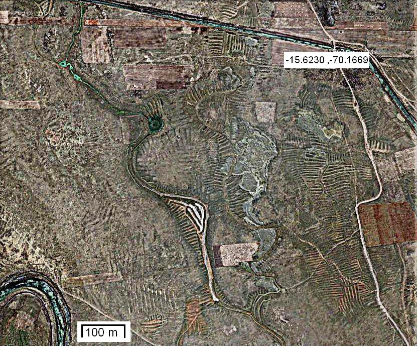
4 Geoglyphs of Titicaca Amelia Carolina Sparavigna A network of ancient earthworks covers a large part of the land near the Titicaca Lake. The slopes of hills are criss-crossed with terrace walls and the surfaces of the plains covered with raised fields, indicating that this was once a highly productive agricultural place for the south central Andes. Using the Google Maps satellite imagery, we discover that some landforms are geoglyphs, with a clear symbolic function. Among them, there are animals, where ponds are their eyes. Any landform composed of fine-grained materials evolves in wide and flat relieves, due to the down-slope transport of its materials over time. Earthworks, which are artificial landforms, are subjected to the same destiny, to be widened and flattened as a consequence of the natural degradation processes 1. Sometimes, men are enhancing their degradation. Due to evolution, ancient earthworks become sinusoidal profiles apparent on the current landscape. Therefore, these ancient structures become in the satellite imagery a texture superimposed to the background landform. In some cases, in spite of natural degradation and human actions, these textures remain quite visible. A wonderful example is the really huge network of earthworks, covering a total of 120,000 hectares of the land near the Titicaca Lake. These earthworks are the result of an almost unimaginable agricultural effort of ancient Andean people. Some of the landforms are rather remarkable, having a clear symbolic meaning, being then geoglyphs. Some represent birds, where circular ponds are their eyes. Other animals can be observed in a complete survey of the lands near the lake. Earthworks, canals and ponds are the remains of an extensive ancient agricultural system built and used by Andean peoples centuries ago, throughout the vast high plain surrounding Titicaca Lake. People created a system of raised fields, which were large elevated planting platforms, with the corresponding drainage canals and ponds. This system improved soil conditions, the temperature and moisture conditions for crops. These remains are then providing evidence of the impressive engineering abilities of the peoples who lived there in pre-columbian times. Moreover, this finding contradicts the opinion that considers the lands of the Lake Titicaca to be unproductive agriculturally. Archaeology and the satellite imagery, demonstrate the past richness of the area, 1 Being erosion acting on earthworks, as on all landforms, the study of those structures with known age and initial morphology is particularly interesting for geophysical researches. Comparing the original with the current shape provides the data for developing and testing models for long-term landform erosion. Such investigation was applied, for instance, to the Inca agricultural terraces abandoned at 1532 A.D. in the dry lands of southern Peru, see for instance, Pattern and rate of erosion inferred from Inca agricultural terraces in arid southern Peru, Ana C. Londoño, Geomorphology, Volume 99, Issues 1-4, 1 July 2008, Pages 13-25; Modeling the natural degradation of earthworks, M.A. O'Neal, M.E. O'Mansky, J.A. MacGregor, Geoarchaeology,Volume 20, Issue 7, October 2005, Pages
5 due to this vast complex of agricultural earthworks. The local farmers call the artificial landforms "waru waru" or "camellones" (pre-hispanic raised fields are present in other regions too 2 ). The local farmers of Titicaca had no idea that these textures are the persisting evidence of remarkable skills of their ancestors, until 1981, when Clark Erickson, University of Illinois, recognized the significance of waru waru. He and other researchers started an experimental reintroduction of raised fields, in the Huatta, a land near the lake, in Peru. They persuaded some local farmers to rebuild a few of the raised fields, plant them in indigenous crops, and farm in traditional manner. Archaeological and experimental data suggest that raised fields might be more appropriate for the region 3. Let us observe the satellite images. Lake Titicaca sits 3,811 m above sea level, in a basin high in the Andes on the border of Peru and Bolivia. The western part of the lake lies within the Puno Region of Peru, and the eastern side is located in the Bolivian La Paz Department. Both regions have the slopes of the hills criss-crossed with terrace walls. Some parts of the plain surfaces are covered with raised fields, indicating that this was once a highly productive agricultural place for the south central Andes. As earthworks, raised fields are constructed by excavating parallel canals and piling the earth between them creating long and low mounds, surfaces being flat or convex. These raised platforms created a local micro-environment, able to reduce the frost risk for crops. The canals between raised fields act as sources of moisture during the periods of drought. Moreover, water in the deep canals and in ponds might have been used to cultivate aquatic plants and fish, as well as attract lake birds 4. The raised fields of Titicaca have different forms and size, generally being 4-10 m wide, 10 to 100 m long, and 1 m tall. At a later time, the wavelength increased for larger fields to 10 m. In spite of erosion, the network of these not so-high earthworks is clearly visible from the space. This book shows a collection on images from the Google Maps imagery, enhanced with image processing tools 5. We can see many textures having a clear symbolic evident planning: these artificially landforms are then geoglyphs. Moreover, we can suggest a rule of thumb: to find the geoglyphs, look for circular ponds, because sometimes they can be the eye of an animal. Many geoglyphs are in Peru. In Bolivia we find a large area (located approximately at coordinates , ) where the raised fields have a different style 6. Here too, we see beautiful landforms, showing snakes, birds and other objects, not so easy to figure out. Let us then start our survey of the geoglyphs of Titicaca. Coordinates are reported in the figures. 2 Pre-Columbian earthworks in coastal Amazonia, S. Rostain, Diversity, Volume 2, 2010, Pages ; Pre-Hispanic Raised Field Agriculture, C. Erickson, web page, Agricultural Earthworks on the French Guiana Coast, S. Rostain, The Handbook of South-American archaeology, Volume 3, 2008, Pages Raised field agriculture in the Lake Titicaca basin, C.L. Erickson, Expedition, Volume 30(1), 1988, Pages Idem 5 To have an idea of the processing procedure used for the images shown in this book, the reader can see the paper entitled, Enhancing the Google imagery using a wavelet filter, A.C. Sparavigna, 8 Sept Geophysics (physics.geo-ph); Earth and Planetary Astrophysics (astro-ph.ep), arxiv: The Bolivian geoglyphs were discussed in a post of February 24, 2008, by David E. Flynn, post with a surprising title: Discovery of vast prehistoric works built by Giants? The Geoglyphs of Teohuanaco; see also the page by J.M.Allen, 5th Nov 2009, 4

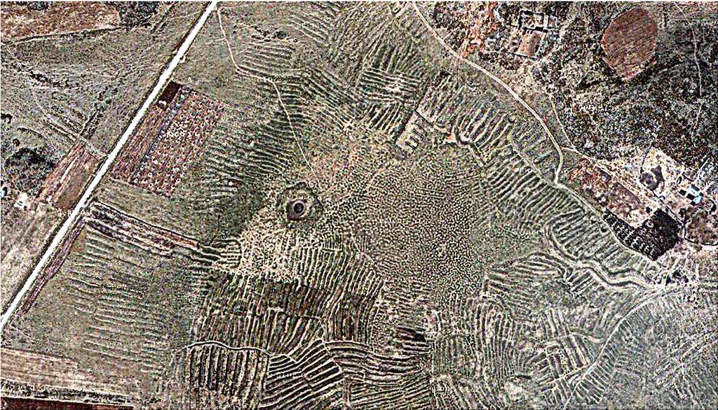
6 Peru Here we see a plain region quite interesting. Two areas are pointed out that we shall observed in detail in the two following images. 5
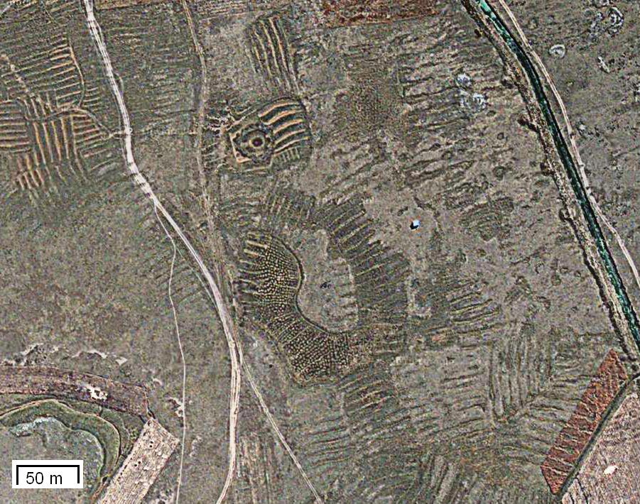
7 This is the head of a bird, where a circular pond is the eye. 6

8 An ant-bear? 7

9 Peru Here we see a canal and the beak and claw of a bird at two bends of it. Note that here we have two geoglyphs, that we see in the following two images in detail. 8
10 9

11 Peru A hedgehog (originally upside-down). 10
 on the plain surface of the ground, a pond as its eye. Note the bifid tongue.")
12 Peru A snake, with the body and texture of skin created by the terraced hill (left part of the image), the head (darker area) on the plain surface of the ground, a pond as its eye. Note the bifid tongue. 11

13 Peru The detail of the head. 12

14 Peru The snake is not alone. It is an element of a more complex drawing, with another animal, which seems assailing the snake. 13

15 Peru Sometimes, a geoglyph is beautiful and well preserved but difficult to identify (a fish?, a tortoise?). 14


16 Peru Another interesting plain area. 15

17 Is this landform representing a condor? 16


18 This is the destiny of ancient earthworks, cancelled by time, modern cultivations and roads. 17

19 Peru No comment 18

20 Peru Head of a bird. The beak is touching an old dry channel (upside-down). 19

21 Peru It looks like the head of a bird. In any case, we can argue that the creation of earthworks was previously planned, following the natural slope of the terrain. The image, with a suitable processing, allows observing all the minute details. 20

22 Peru A star and stripes creation. 21

23 Peru Another star and stripes. 22

24 Peru Abstract drawing. 23

25 Bolivia A canal or a snake near Tiwanaku. 24

26 Bolivia A snake and a bird near Ancocahua and Aygachi. Note teeth and tongue of the snake. 25

27 Bolivia Artistic visions. 26

28 Bolivia A flying macaw. 27
29 To be continued 28
Latin America s Physical Geography. EQ: What are characteristics of Latin America s physical features?
 Latin America s Physical Geography EQ: What are characteristics of Latin America s physical features? Your Task: We are going to participate in a Museum Walk! You will travel around the room with a partner
Friday, November 10, 2017
 Friday, November 10, 2017 Andes and Midlatitude Countries Objective: Summarize the main physical features and regions of the Southern Cone. Identify and locate the urban centers and understand the pattern
A funny sounding lake. South American Landforms, Climate, and Vegetation
 A funny sounding lake South American Landforms, Climate, and Vegetation 3 4 Essential Question: How have physical features and climate affected the population distribution of Latin America? 5 I. Landforms
ISOM & ISSOM forbidden symbol comparison
 & forbidden symbol comparison Forbidden symbols and their relatives Symbol 2000 (Long, Middle) 2007 (Sprint) 201 Impassable cliff An impassable cliff, quarry or earth bank (see 106) is shown with a 0.35
MONTEVECCHIA Pyramid Hills.. Summary 9 pages
 Gabriela Lukacs, Mag.rer.soc.oec., graduate Vienna university Post graduate art +history university Siena, Italy Participant of the excavations in Visoko, Bosnia since 2006 Grinzinger Allee 15, 1190 Wien,
Inca Pilgrimage - Part IV (Bolivia)
") Inca Pilgrimage - Part IV (Bolivia) This the part IV of our Pilgrimage - Bolivia, our fourth country. Our journey in Bolivia took us first to La Paz, the highest capital in the world. It was really cold
Inca Pilgrimage - Part IV (Bolivia) This the part IV of our Pilgrimage - Bolivia, our fourth country. Our journey in Bolivia took us first to La Paz, the highest capital in the world. It was really cold
THE ANDEAN AREA....How does the rich countries development affect some poor and 1. distant countries
 THE ANDEAN AREA...How does the rich countries development affect some poor and 1 distant countries 1. Geographical situation of the Andean area South America view 2 Andes mountain range Amazonian basin
SAMt. INCA tour Chile - Peru. Total Kilometers days 10 nights
 An ADVENTURE of an incredible mixture of mystical archaeology sites and historical monuments, amazing nature combined with one of the oldest and most diverse cultures in South America. LIFE IS NOT - WITHOUT
AUTHENTIC travel experiences
 www.intenseperu.com AUTHENTIC travel experiences intense peru online travel agency and tour operator We are an experienced online travel agency and tour operator. We create authentic and unforgettable
Lidar Imagery Reveals Maine's Land Surface in Unprecedented Detail
 Maine Geologic Facts and Localities December, 2011 Lidar Imagery Reveals Maine's Land Surface in Unprecedented Detail Text by Woodrow Thompson, Department of Agriculture, Conservation & Forestry 1 Introduction
Latin America. Chapter 9 Physical Geography
 Latin America Chapter 9 Physical Geography Latin American Regions Middle America includes Mexico and the Central American countries The Caribbean Islands South America Mexico Landforms Sierra Madre Oriental
Raised Field Agriculture in the Lake Titicaca Basin: Putting Ancient Agriculture Back to Work
 University of Pennsylvania ScholarlyCommons Department of Anthropology Papers Department of Anthropology 1988 Raised Field Agriculture in the Lake Titicaca Basin: Putting Ancient Agriculture Back to Work
LAST TIME (Happy 300 th Birthday Ben Franklin!)
") LAST TIME (Happy 300 th Birthday Ben Franklin!) Latin American Diversity: Introduction Physical Geography of Mexico, Caribbean, and Central America: 1. Mexican drylands 2. Mesoamerican Highlands 3. Coastal
LAST TIME (Happy 300 th Birthday Ben Franklin!) Latin American Diversity: Introduction Physical Geography of Mexico, Caribbean, and Central America: 1. Mexican drylands 2. Mesoamerican Highlands 3. Coastal
Remote Sensing into the Study of Ancient Beiting City in North-Western China
 Dingwall, L., S. Exon, V. Gaffney, S. Laflin and M. van Leusen (eds.) 1999. Archaeology in the Age of the Internet. CAA97. Computer Applications and Quantitative Methods in Archaeology. Proceedings of
Death Valley Is a Beautiful but Dangerous Place
 Death Valley Is a Beautiful but Dangerous Place Welcome to This Is America with VOA Learning English. Today we visit one of America s great national parks. It is a place of strange and silent beauty. As
Geographic Qualities of South America
 Geographic Qualities of South America 1. South America is the fourth largest continent in area. It is located in the Western Hemisphere, lying southwest of North America. Most of South America lies in
Essential Questions. 1. How have historical figures and events affected South America today?
 South America Essential Questions 1. How have historical figures and events affected South America today? 2. How has location affected the development of countries in South America? 3. How has the role
On the spot. Archaeology and satellite imagery. Pleiades Archaeology Collection
 On the spot With satellite imagery archaeology is enjoying a new golden age. The archaeologists now have an extensive and precise array of tools for detecting ancient remains. In addition to this support
Early Andean Civilizations. Origins and Foundations
 Early Andean Civilizations Origins and Foundations Environmental Context Basic divisions: east/west, north/south Mountains, deserts, and rivers Vertical archipelago : adapting to climate diversity based
INTRODUCTION ITINERARY BOLIVIA - HIGHLIGHTS OF BOLIVIA TRIP CODE BOTSBOH DEPARTURE. Daily DURATION. 7 Days LOCATIONS
 INTRODUCTION This tour is a suggested itinerary designed by our specialist team! Choose this itinerary or alter it to design your own Journey. Discover the highlights of this fascinating country with its
South America. pg. 520 (5 th) pg. 523 (6 th )
 pg. 523 (6 th )") South America pg. 520 (5 th) pg. 523 (6 th ) Venezuela Rich in Oil Lake Maracaibo Called Little Venice pg. 572 (5 th) pg. 574 (6 th ) Caracas 8 miles Inland 3000 pg. 572 (5 th) pg. 574 (6 th ) Caracas
South America pg. 520 (5 th) pg. 523 (6 th ) Venezuela Rich in Oil Lake Maracaibo Called Little Venice pg. 572 (5 th) pg. 574 (6 th ) Caracas 8 miles Inland 3000 pg. 572 (5 th) pg. 574 (6 th ) Caracas
GUIDE PERU & BOLIVIA 28 DAYS SUMMER 2019
 GUIDE PERU & BOLIVIA SUMMER 2019 28 DAYS WHERE ARE YOU GOING? PERU & BOLIVIA These two neighbouring countries offer so many adventures and unmissable sights, it wouldn t be right to visit one and not the
Objective. Students will familiarize themselves with the physical features and climates of Latin America.
 Journal Write KWL What do you KNOW about Latin America? What do you WANT TO KNOW about Latin America? What did you LEARN today that you didn t know before? Latin America Objective Students will familiarize
Andes Majesty Atacama and Bolivia
 Andes Majesty Atacama and Bolivia This 13-day journey takes the intrepid traveller through the dazzling lunar landscapes of the high Andes. Explore this ultimate wilderness in a private 4x4 and admire
LA PAZ AND ATACAMA DESERT TOUR The Bolivia to Chile Tour ITINERARY
 LA PAZ AND ATACAMA DESERT TOUR The Bolivia to Chile Tour 8 DAYS / 7 NIGHTS Stark contrasts: From the Bolivian Capital to the wonders of the Atacama Desert! Astounding contrasts as you journey from La Paz
KAYAKING LAKE TITICACA
 KAYAKING LAKE TITICACA FROM $520 4 days / 3 nights MODERATE TRIP Knowmad specializes in private and custom travel. Itineraries and physical difficulty are often flexible. TRIP HIGHLIGHTS Kayak to remote
Runway Roughness Evaluation- Boeing Bump Methodology
 FLIGHT SERVICES Runway Roughness Evaluation- Boeing Bump Methodology Michael Roginski, PE, Principal Engineer Boeing Airport Compatibility Engineering ALACPA XI Seminar, Santiago, Chile September 1-5,
GC 225 Lecture Exam #2
 GC 225 Lecture Exam #2 Direction- path along which something is moving. 3 Types; - COMPASS DIRECTIONAL NAME (32 in total) - BEARING (four 0 o - 90 o ) - AZIMUTHS (0 o - 360 o ) Compass (32 named points)
STUDY GUIDE. The Land. Physical Features of Latin America. Chapter 8, Section 1. Terms to Know DRAWING FROM EXPERIENCE ORGANIZING YOUR THOUGHTS
 For use with textbook pages 193 198. The Land Terms to Know cordillera A mountain range that runs parallel to another mountain range (page 194) altiplano A high plain (page 194) escarpment A steep cliff
Chapter 7 Geography and the Early Settlement of Egypt, Kush, and Canaan
 Chapter 7 Geography and the Early Settlement of Egypt, Kush, and Canaan How did geography affect early settlement in Egypt, Kush, and Canaan? Section 7.1 - Introduction RF/NASA//Corbis This satellite photograph
Following the initial soil strip archaeology is sprayed up prior to planning and excavation
 Barton Quarry & Archaeology Over the past half century quarries have been increasingly highlighted as important sources of information for geologists, palaeontologists and archaeologists, both through
Brazil Today The Amazon River and Basin
 Non-fiction: Brazil Today The Amazon River and Basin Brazil Today The Amazon River and Basin Deep within the Andes Mountains of northern Peru, two rivers flow together. Their junction forms one of the
South American Countries. Capital Location Population Terrain Climate
 South American Countries Capital Location Population Terrain Climate Andes Mountains Four large areas that make up the Central Plains: Llanos, the Selva, the Gran Chaco, and the Pampas Brazilian Highlands
EXPLORING EARTH S SURFACE. Lesson 4
 EXPLORING EARTH S SURFACE Lesson 4 Introduction Lewis and Clark In 1804, an expedition set out from near Saint Louis to explore the land between the Mississippi River and the Pacific Ocean, The United
AP US History: An Essential Coursebook (2nd Ed)
") Unit One: Early Native and Colonial Societies (1491-1754) Chapter One: Pre-Columbian Societies AP US History: An Essential Coursebook (2nd Ed) Environment and Geography How did physical features affect
Unit One: Early Native and Colonial Societies (1491-1754) Chapter One: Pre-Columbian Societies AP US History: An Essential Coursebook (2nd Ed) Environment and Geography How did physical features affect
What Is An Ecoregion?
 Ecoregions of Texas What Is An Ecoregion? Ecoregion a major ecosystem with distinctive geography, characteristic plants and animals, and ecosystems that receives uniform solar radiation and moisture Sometimes
Lecture #1: Introduction
 Anthropology G4210 The Rise of Andean Civilization T. D'Altroy September 8, 1999 Lecture #1: Introduction 1. purposes of the course a. examination of the nature and development of societies in the Andes
CHAPTER 12. South America. Section 1: Natural Environments Section 2: History and Culture Section 3: South America Today. HOLT World Geography
 CHAPTER 12 South America Section 1: Natural Environments Section 2: History and Culture Section 3: South America 1 Section 1 Natural Environments Objectives: What are the major landforms and rivers of
Mountains. Erinn Banting
 Mountains Erinn Banting Published by Weigl Publishers Inc. 350 5 th Avenue, Suite 3304, PMB 6G New York, NY 10118-0069 Web site: www.weigl.com Copyright 2007 Weigl Publishers Inc. All rights reserved.
GUIDE PERU & BOLIVIA 28 DAYS SUMMER 2019
 GUIDE PERU & BOLIVIA SUMMER 2019 28 DAYS These two neighbouring countries offer so many adventures and unmissable sights, it wouldn t be right to visit one and not the other! Peru and Bolivia offer a truly
Physical. and. Human-made. Features
 Directions for Making a Geographic Features Vocabulary Book 1. Cut the photographs boxes out of page 2 and sort the them into two groups: physical features and human-made features. 2. Correctly match each
Thank you very much for contacting Machu Travel Peru.
 Dear, Thank you very much for contacting Machu Travel Peru. Our packages are 100% customizable so feel free to modify, change or add anything you wish on it. We want you to take the best of our country:
GOOSENECK SWAMP INFORMATION DAY - Saturday 14 th December 2013
 GOOSENECK SWAMP INFORMATION DAY - Saturday 14 th December 2013 Progress of a restoration trial at Gooseneck Swamp - Grampians National Park, Victoria Gooseneck Swamp is situated at the far south-eastern
Andean States. Cycles of Expansion and Collapse
 Andean States Cycles of Expansion and Collapse Timeline Early Intermediate Period (200BCE AD 600) North Coast: Moche Civilization Southern Pole : Nazca Middle Horizon (AD 600 1000) First Highland States:
Latin America. Physical Geography
 + Latin America Physical Geography + I. Landforms A. Caribbean & Central America 1. Mexico is dominated by two mountain chains, collectively called the Sierra Madre. A high plateau is situated in between.
Welcome to the online gallery of the Foundation for Landscape Studies..
 Welcome to the online gallery of the Foundation for Landscape Studies.. This exhibition is contained in an Acrobat file designed to open in full-screen mode, which will enable you to view the images in
Runway Roughness Evaluation- Boeing Bump Methodology
 FLIGHT SERVICES Runway Roughness Evaluation- Boeing Bump Methodology Michael Roginski, PE, Principal Engineer Boeing Airport Compatibility Engineering ALACPA X Seminar, Mexico City, Mexico September 30-
Rivers. Highlights of some of the World s Most Famous Rivers!
 Rivers Highlights of some of the World s Most Famous Rivers! Directions This Power Point presentation contains information about some of the most famous rivers in the world! Students should use this presentation
EUROPEAN COMMISSION DIRECTORATE-GENERAL HUMANITARIAN AID AND CIVIL PROTECTION - ECHO
 EUROPEAN COMMISSION DIRECTORATE-GENERAL HUMANITARIAN AID AND CIVIL PROTECTION - ECHO Monthly report number 2013/10 Month OCTOBER Country South America (except Colombia for HA) Date of submission 08/11/13
Runway Roughness Evaluation- Boeing Bump Methodology
 FLIGHT SERVICES Runway Roughness Evaluation- Boeing Bump Methodology Michael Roginski, PE, Principal Engineer Boeing Airport Compatibility Engineering ALACPA X Seminar, Mexico City, Mexico September 3-
ANCIENT INCA Worksheets
 ANCIENT INCA Worksheets Contents 1. Ancient Inca Facts 2. Where is Ancient Inca? 3. Machu Picchu 4. Inca Art 5. Identifying Concept 6. Inca Legacy 7. Ancient Inca Word Search 8. Justify It 9. Directing
Module 1 Educator s Guide: Representative Discussion Points Investigation 3
 Module 1 Educator s Guide: Representative Discussion Points Investigation 3 Ethiopia and Eritrea Our combined population is 59,578,171 people. We have just emerged from a long period of civil war and famine.
Chapter 7: Vocabulary (Use the Glossary in the back of your textbook) Chapter 7: Places (Use the Gazetteer in the back of your textbook)
 Chapter 7: Places (Use the Gazetteer in the back of your textbook)") Name Period Chapter 7 Study Guide Chapter 7: Vocabulary (Use the Glossary in the back of your textbook) Review 10-15 min. EVERY Night p. 188 archipelago: p. 188 biome: p. 199 quipu: p. 188 scrub land:
Name Period Chapter 7 Study Guide Chapter 7: Vocabulary (Use the Glossary in the back of your textbook) Review 10-15 min. EVERY Night p. 188 archipelago: p. 188 biome: p. 199 quipu: p. 188 scrub land:
Development and Conservation of Cultural Resources in Central America
 55 Development and Conservation of Cultural Resources in Central America: Japanese International Cooperation for World Heritage Sites of Maya Civilization Seiichi Nakamura Professor of Cyber University
Exploring South America Learning Lapbook with Study Guide
 A J T L Grades 1-4 Exploring South America Learning Lapbook with Study Guide A Journey Through Learning www.ajourneythroughlearning.com Copyright 2013 A Journey Through Learning 1 Authors-Paula Winget
Waquichastati? : Aymara and Quechua in the Cataloging of Bolivian Materials
 St. Cloud State University therepository at St. Cloud State Library Faculty Publications Library Services 2011 Waquichastati? : Aymara and Quechua in the Cataloging of Bolivian Materials Tina Gross St.
GUIDE PERU & BOLIVIA 28 DAYS
 GUIDE PERU & BOLIVIA 28 DAYS SUMMER 2019 WHERE ARE YOU GOING? PERU & BOLIVIA These two neighbouring countries offer so many adventures and unmissable sights, it wouldn t be right to visit one and not or!
Latin America. Introduction
 Latin America Introduction What are the 5 Themes of Geography? Draw lines to connect the theme to the definition: Location How humans and the environment impact each other Physical and human characteristics
ECUADOR: A Case Study. How have humans changed their environment?
 ECUADOR: A Case Study How have humans changed their environment? How have humans changed their environment? Human beings over the course of history have changed their physical surroundings to meet their
INKA TRAIL PICTURES - thanks to Sandip. INKA TRAIL PICTURES - thanks to Ann Mickle. INKA TRAIL PICTURES - thanks to Andreas
 Note: The Sacred Valley tour and Inca Trail pictures will be coming as soon as I get a little help from friends that I made along the way. They promised to send me some pictures because my camera was stolen
The Pilcomayo River Basin Argentina
 The Pilcomayo River Basin Argentina Yangareko ( Janis Alcorn, Alejo Zarzycki, Alonzo Zarzycki, Luis Maria de la Cruz) Governance and Ecosystems Management for the CONservation of BIOdiversity www.gemconbio.eu
How the Incas Engineered a Road Across Extreme Terrain By Smithsonian.com
 How the Incas Engineered a Road Across Extreme Terrain By Smithsonian.com Every June, after the rainy season ends in the highlands of southern Peru, the residents of four villages near Huinchiri, at more
GLACIATION. The Last Ice Age (see Chapter 12) and. Pleistocene Ice Cap. Glacial Dynamics 10/2/2012. Laurentide Ice Sheet over NYS
 and. Pleistocene Ice Cap. Glacial Dynamics 10/2/2012. Laurentide Ice Sheet over NYS") GLACIATION and New York State Prof. Anthony Grande The Last Ice Age (see Chapter 1) The Pleistocene Epoch began 1.6 mya. During this time, climates grew colder. There were numerous ice ages starting 100,000000
GLACIATION and New York State Prof. Anthony Grande The Last Ice Age (see Chapter 1) The Pleistocene Epoch began 1.6 mya. During this time, climates grew colder. There were numerous ice ages starting 100,000000
ALBERTA S GRASSLANDS IN CONTEXT
 ALBERTA S GRASSLANDS IN CONTEXT GLOBAL GRASSLANDS 1 Temperate grasslands, located north of the Tropic of Cancer and south of the Tropic of Capricorn, are one of the world s great terrestrial biomes 2.
I. INTRODUCTION. Continental Introduction 3 II. EARLY OCCUPATIONS OF SOUTH AMERICA. 5. The Process of Sedentism in Northwestern South America 79
 I. INTRODUCTION Continental Introduction 3 Helaine Silverman II. EARLY OCCUPATIONS OF SOUTH AMERICA 2- Profiles in Pleistocene History 29 Tom D. Dillehay Chinchorro Culture: Pioneers of the Coast of the
MIDDLE SCHOOL CURRICULUM TR AILING ICE AGE M YST ERI E S SEARCHING GLACIAL FEATURES
 MIDDLE SCHOOL CURRICULUM TR AILING ICE AGE M YST ERI E S SEARCHING GLACIAL FEATURES CONTENTS I. Enduring Knowledge... 3 II. Teacher Background... 3 III. Before Viewing the Video... 5 IV. Viewing Guide...
Latin America. Physical Geography
 Latin America Physical Geography Regions Latin America can be divided into separate regions based on physical geography or cultural geography. Regions If we look at physical geography Latin America has
MACHU PICCHU AND LA PAZ TOUR & LAKE TITICACA CRUISE Travel in the Footsteps of the Incas from Lima to Cuzco, Machu Picchu, Lake Titicaca & La Paz
 MACHU PICCHU AND LA PAZ TOUR & LAKE TITICACA CRUISE Travel in the Footsteps of the Incas from Lima to Cuzco, Machu Picchu, Lake Titicaca & La Paz 10 DAYS / 9 NIGHTS Travel to Machu Picchu and La Paz on
CUSCO, SACRED VALLEY & MACHU PICCHU
 CUSCO, SACRED VALLEY & MACHU PICCHU (04 days / 03 nights) Description: Enjoy a quick tour package of the Cusco s main tourist attractions. It was in Peru that the mighty Inca Empire flourished and the
What endures from the ancient civilizations that ruled the Andes?
 What endures from the ancient civilizations that ruled the Andes? By Smithsonian Institution, adapted by Newsela staff on 07.19.17 Word Count 1,113 Level 1020L Archaeological site in Moray, Peru, where
Brain Wrinkles. Africa: The impact of location, climate, & physical characteristics on where people live, the type of work they do, & how they travel
 Africa: The impact of location, climate, & physical characteristics on where people live, the type of work they do, & how they travel STANDARDS: SS7G3 The student will explain the impact of location, climate,
Ecotourism and conservation in the Americas (book review)
") Ecotourism and conservation in the Americas (book review) Author Buckley, Ralf Published 2010 Journal Title Journal of Ecotourism DOI https://doi.org/10.1080/14724040903056424 Copyright Statement 2010
Ecotourism and conservation in the Americas (book review) Author Buckley, Ralf Published 2010 Journal Title Journal of Ecotourism DOI https://doi.org/10.1080/14724040903056424 Copyright Statement 2010
LIMA NAZCA AREQUIPA PUNO CUSCO 15 Days / 14 Nights
 LIMA NAZCA AREQUIPA PUNO CUSCO 15 Days / 14 Nights Include Programs Lima Transfer in out 3 nights accommodation in Lima + breakfast City tours in Lima Tickets to tourist attractions All services are shared.
Satellite Imagery Briefing: Monitoring Endangered Cultural Heritage Sites
 Satellite Imagery Briefing: Monitoring Endangered Cultural Heritage Sites Early Warning and Threat Monitoring System for Cultural Heritage Sites in the Developing World March 2011 Endangered Global Heritage
Chapter 7. Geography and the Early Settlement of Egypt, Kush, and Canaan
 Chapter 7 Geography and the Early Settlement of Egypt, Kush, and Canaan Chapter 7 Geography and the Early Settlement of Egypt, Kush, and Canaan How did geography affect early in Egypt Kush, and Canaan?
What Makes a Complex Society Complex?
 What Makes a Complex Society Complex? The Dresden Codex. Public domain. Supporting Questions 1. How did the Maya use writing to represent activities in their culture? 2. What did the Aztecs do to master
USDA TRAILS STRATEGY PROGRAM
 USDA TRAILS STRATEGY PROGRAM WRPI Program: English Peak Survey Jorge D. Briceño Southwestern Community College Internship Time Period: June 6, 2016 August 8, 2016 Advisor: Sam Commarto Recreation Officer
INTRODUCTION ITINERARY BOLIVIA - TITICACA LAKE EXPERIENCE & UYUNI SALT FLATS TRIP CODE BOTSTLE DEPARTURE
 INTRODUCTION The Chimu Collections range consists of boutique properties, cruises & itineraries, throughout Latin America, designed for travellers seeking unique experiences. La Paz is the world s highest
Introduction to Africa
 Introduction to Africa Did you know? Africa has more countries than any other continent. The Sahara is a desert that is the size of the U.S. It s the world's largest desert. Most of the world s gold and
Chapter 19 Test on South America
 Name Part 1 - Labeling (27 pts.) Chapter 19 Test on South America Score A. Locate the countries and territory contained in the word box below on the map of South America on the next page. Write the name
Prof. Dr Željko Vaško Doc. Dr Tihomir Predić MSc Boris Marković
 First Interim Meeting of the Regional Expert Advisory Working Group on Areas with Natural Constrains Prof. Dr Željko Vaško Doc. Dr Tihomir Predić MSc Boris Marković 29 th June 01 th July, 2016 Andrevlje,
Honors thesis. Master degree in Architecture for the sustainable project. Abstract PARALLEL TERRITORIES
 Honors thesis Master degree in Architecture for the sustainable project Abstract PARALLEL TERRITORIES Venice and the minor islands of the Venetian lagoon. Transformation scenarios for Poveglia. Tutor Angelo
TOWERBUTTE. Lewis and Clark s. >> By Jerry Penry, LS
 4.95 Lewis and Clark s TOWERBUTTE >> By Jerry Penry, LS Have you ever felt like you are standing on hallowed ground, knowing that some very important surveyors had previously occupied that same location?
GRANDE News Letter Volume1, No.3, December 2012
 GRANDE News Letter Volume1, No.3, December 2012 Building a water management system in La Paz, Bolivia Climate change is a phenomenon that affects the entire world, but its impact on people differs depending
Just how big is Africa?
 The United States China India The United Kingdom Portugal Spain France Belgium Germany The Netherlands Switzerland Italy Eastern Europe Japan 11.7 million sq. miles Just how big is Africa? Chapter 18 Section
The Exploration Foundation s 2011 Archaeological Field School in Honduras at the Formative Period Center of Yarumela
 The Exploration Foundation s 2011 Archaeological Field School in Honduras at the Formative Period Center of Yarumela July 9 th -Aug 12 2011 This field school offers students the opportunity to participate
GLACIER STUDIES OF THE McCALL GLACIER, ALASKA
 GLACIER STUDIES OF THE McCALL GLACIER, ALASKA T John E. Sater* HE McCall Glacier is a long thin body of ice shaped roughly like a crescent. Its overall length is approximately 8 km. and its average width
UNITED NATIONS EDUCATIONAL, SCIENTIFIC AND CULTURAL ORGANIZATION CONVENTION CONCERNING THE PROTECTION OF THE WORLD CULTURAL AND NATURAL HERITAGE
 World Heritage Distribution limited 27 COM WHC-03/27.COM/INF.13 Paris, 23 June 2003 Original : English/French UNITED NATIONS EDUCATIONAL, SCIENTIFIC AND CULTURAL ORGANIZATION CONVENTION CONCERNING THE
Discover the Sacred Valley & Lares Region. 9 Days
 Discover the Sacred Valley & Lares Region 9 Days Discover the Sacred Valley & Lares Region Just north of Cusco lies a little-traveled region of tranquil lakes and rugged peaks, where farmers have grown
Alpine Glacial Features along the Chimney Pond Trail, Baxter State Park, Maine
 Maine Geologic Facts and Localities September, 2009 Alpine Glacial Features along the Chimney Pond Trail, Baxter State Park, Maine 45 54 57.98 N, 68 54 41.48 W Text by Robert A. Johnston, Department of
Presentation: UAS Helicopter Waran -1-
 Presentation: UAS Helicopter Waran -1- The unique design features of the Waran provide a superior payload capacity, prolonged endurance, stable flight patterns and a high degree of safety features. Technical
Glacial lakes as sentinels of climate change in Central Himalaya, Nepal
 Glacial lakes as sentinels of climate change in Central Himalaya, Nepal Sudeep Thakuri 1,2,3, Franco Salerno 1,3, Claudio Smiraglia 2,3, Carlo D Agata 2,3, Gaetano Viviano 1,3, Emanuela C. Manfredi 1,3,
World of the Incas and the North American Indians. Willow LeTard and Kevin Nguyen
 World of the Incas and the North American Indians Willow LeTard and Kevin Nguyen World of the Twantinsuyu 1300 c.e. in the Andean highlands Notable advances in metallurgy and architecture The Incas had
6th Grade Social Studies Chapter 7: The Geography and Early Settlement of Egypt, Kush and Canaan
 I. Introduction (7.1) A. Egyptians settled along the Nile River, in the NE corner of Africa B. civilization lasted from around 3100 B.C. to 350 C. E. C. Kushites settled to the south of Egypt, along the
A love of travelling
 Part 1 For questions 1 12, read the text below and decide which answer (A, B, C or D) best fits each gap. There is an example at the beginning (0). Mark your answers on the separate answer sheet. Example:
Perth and Kinross Council Development Control Committee 27 August 2008 Recommendation by Development Quality Manager
 Perth and Kinross Council Development Control Committee 27 August 2008 Recommendation by Development Quality Manager 5(7) 08/414 Erection of kennels and cattery at Baltree Farm, Hatchbank, Kinross, KY13
A Study of Ancient Resharpening
 A Study of Ancient Resharpening By James R. Bennett, Jim Fisher, & Dan Long Published in Identifying Altered Ancient Flint Artifacts: Relics & Reproductions Series Book II by James R. Bennett The goal
2012. Proceedings of the 11 European Geoparks Conference. AGA Associação Geoparque Arouca, Arouca, 5-6.
 References to this volume It is suggested that either the following alternatives should be used for future bibliographic references to the whole or part this volume: th Sá, A.A., Rocha, D., Paz, A. & Correia,
Explore Jane Crider's board "Dinosaurs etc" on Pinterest. See more ideas about Prehistoric animals, Extinct animals and Dinosaurs.
 Do Dinosaurs Fly? Prehistoric Animal Learning For Kids Of All Ages: Dinosaur Books Encyclopedia For Kids (Children's Prehistoric History Books) By BaProfessor READ ONLINE Explore Jane Crider's board "Dinosaurs
Ingvarsstenen (the Ingvar s stone)
") THE RUNE STONE PATH Ingvarsstenen (the Ingvar s stone) "Sven and Sten raised this stone after Toste, their father, who died in Ingvar's retinue. And after Torsten and after Östen, the son of Alvhild."
THE RUNE STONE PATH Ingvarsstenen (the Ingvar s stone) "Sven and Sten raised this stone after Toste, their father, who died in Ingvar's retinue. And after Torsten and after Östen, the son of Alvhild."