TOWERBUTTE. Lewis and Clark s. >> By Jerry Penry, LS
|
|
|
- Tracy Clark
- 5 years ago
- Views:
Transcription
1 4.95
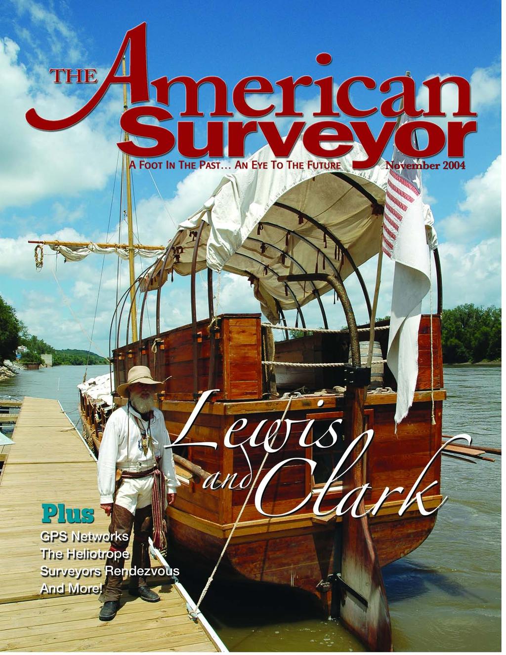
2 Lewis and Clark s TOWERBUTTE >> By Jerry Penry, LS Have you ever felt like you are standing on hallowed ground, knowing that some very important surveyors had previously occupied that same location? This was the situation when Gene Thomsen and I, both Nebraska surveyors, stood at the base of the very hill where Meriwether Lewis and William Clark had stood exactly two hundred years earlier on September 7, Although Lewis and Clark often described their stopping locations during their Corps of Discovery trip up the Missouri River, the exact locations of many of these sites are very hard to pinpoint. A large portion of the river has been channelized, and many of the landscape and other natural features they described are no longer discernable. However, one feature has remained virtually unchanged for the past two centuries and was one of Lewis and Clark s final stops in the area of the present day borders of Nebraska and South Dakota. Captain Clark referred to the land feature as a round mounting resembling a dome, or a cupola that he had spotted the previous day. Two of the other crew members who had accompanied Lewis and Clark on this expedition also recorded their impressions. Sergeant Gass described it as being a round knob of a hill in a prairie. Sergeant Ordway described it as being a round naked high knob, and that it resembled something made by the hand of man. After traveling only five and one-half miles that late summer morning, the explorers decided to spend the rest of the day on shore. With four other men, Lewis and Clark trekked the halfmile distance to the hill to examine it more closely. It was at this location that the explorers first encountered the prairie dog that French traders had earlier reported. Other members of the party were summoned to bring every available pot or kettle full of water to drown one out of its burrow. The Tower Butte, as it became known, could have slipped into obscurity after the visit by Lewis and Clark; however, in subsequent years, several different surveyors made their presence at this hill that had long been known to the Native Americans as a great lookout location. In the mid-1850 s the Teton Sioux were uprising, so General William S. Harney was instructed to establish a permanent milicontinued on page 66

3 GLO Map: The Fort Randall Military Reservation was closed in 1892, which made it open for settlement. When U.S. Deputy Surveyor C.H. Bates surveyed T34N, R10W of the 6th P.M. inside the reservation in 1895, he noted the presence of the military iron posts.


4 Louis and Clark continued from page 63 tary post along the Missouri River, which was in the vicinity of the Tower Butte. The fort was established on June 26, 1856, along the westerly side of the river in present day South Dakota, and was given the name Fort Randall. Four years later the vast Fort Randall Military Reservation was created by Executive Order on June 14, The reservation consisted of 96,000 unsurveyed acres and extended across both sides of the Missouri River and into present-day Nebraska and South Dakota. The perimeter of this reservation was believed to have been surveyed by Lt. J.C. Clark of the 4th Artillery in the latter part of The common last name between Lt. Clark of the 4th Artillery and Captain Clark of the Corps of Discovery is apparently only coincidental. Lt. Clark took advantage of the rounded hill which had been previously described and explored by Lewis and Clark and designed his survey to pass over the top of the dome. This would give him excellent sight distance across both sides of the Missouri River. When the boundary was completed, it lay in a rectangular shape in a northwest to southeast direction. The southeasterly corner of the reservation was situated about four miles southwest of the hill described by Lewis and Clark in Boyd County, Nebraska. Permanent cast iron monuments six inches square and six feet tall marked U.S. MIL. RES N. were erected at the four corners of the reservation, and at both sides of the Missouri River crossings both above and below the fort. Thirty years later the domed hill once again saw the presence of a surveyor when U.S. Deputy Surveyor Robert Harvey retraced the military boundary while subdividing the land into sections outside the reservation in Harvey undoubtedly erected his instrument atop the hill when setting his own corners on the reservation boundary. He later went on to become one of Nebraska s most respected surveyors and obtained the position of being the first state surveyor. The military fort and reservation were closed two years later in November 1892, which then allowed the area to be opened for settlement. In August of 1895 the hill described by Lewis and Clark once again saw another surveyor when U. S. Deputy Surveyor C. H. Bates retraced the reservation boundary when he surveyed the area inside the abandoned reservation. Both Harvey and Bates noted the two prominent iron posts located on the Nebraska side. Many of their original marked corner stones are just waiting to be rediscovered on the native Nebraska prairie. Strange Facts In 1948 the hill saw more surveying activity when the Coast and Geodetic Survey established a triangulation station Nebraska surveyors Jerry Penry (left) and Deputy State Surveyor Gene Thomsen pose along the southerly base of the Tower Butte on Sept. 7, 2004, exactly 200 years after Lewis & Clark had examined the same hill. Iron post (left) is at Gross, Nebraska; iron post (right) is at Lynch, Nebraska.


5 Left: Due to prairie fires and foraging buffalo, the valley between the Tower Butte and the river would have been void of trees in Right: "Old Baldy," as it is known today, pictured looking northwest toward South Dakota. known as Lynch on the top of another nearby hill located just north of the famous hill. Although this hill is at nearly the same elevation, it supports vegetation, unlike the one described by Lewis and Clark that has remained mysteriously devoid of vegetation after all these years. The two iron posts along the abandoned military reservation in Nebraska remained as permanent sentinels of the abandoned military boundary that was rich in history until they were both stolen around A bizarre twist of events occurred in 2000 when a lawyer drove into the nearby town of Lynch with the two monuments. He had specific instructions to settle an estate of a client who had died a few years earlier. Evidently his client had kept the monuments hidden, but had indicated in his will that they be erected in the towns of Gross and Lynch after his death. The two landowners whose land on which the monuments had once resided, bitterly contested the decision to erect them in the towns, stating they should be returned to their rightful locations. The local sheriff, along with the attorney representing the man who had given up the monuments, refused to give them up, citing that it could not be proven that they were in fact the same two that had been stolen in The monument given to the town of Gross was immediately set in concrete, while the one at Lynch was slid over a concrete post. Within days, the one at Lynch disappeared from the post, but was secretly returned a few days later. It was then also permanently set in concrete. Little did Lewis and Clark know that the round top hill now known as Old Baldy to which they had walked to further investigate would be an attraction to other surveyors. Had they not taken the time to describe this landmark in their journals, it wouldn t have the attraction it still holds two hundred years later. Jerry Penry is employed by Lancaster County Engineering in Lincoln, Nebraska. He has been a licensed surveyor since 1994 specializing in section corner monumentation.
MAY 2017 AROUND THE BEND. Survey Economics Customers & services. Mobile Scanning Bringing the goods. Black Elk Peak Definitive elevation
 MAY 2017 AROUND THE BEND Survey Economics Customers & services Black Elk Peak Definitive elevation Mobile Scanning Bringing the goods TRUE ELEVATION BLACK ELK PEAK» JERRY PENRY, PS Black Elk Peak, located
DISCOVERER OF THE OREGON TRAIL: ROBERT STUART ( ) by Gary Dielman
 by Gary Dielman") DISCOVERER OF THE OREGON TRAIL: ROBERT STUART (1785-1848) by Gary Dielman The Oregon Trail played a huge role in the settlement of the West. With 65 miles of the Oregon Trail in Baker County, it is also
DISCOVERER OF THE OREGON TRAIL: ROBERT STUART (1785-1848) by Gary Dielman The Oregon Trail played a huge role in the settlement of the West. With 65 miles of the Oregon Trail in Baker County, it is also
Maggie s Weekly Activity Pack!
 Maggie s Weekly Activity Pack! Name Date Remembering A Great Adventure The Journey of Lewis and Clark It has been two hundred years since Lewis and Clark started their journey across America. In February
Historic Trails Research. Lewis and Clark Landmark Document
 Historic Trails Research Lewis and Clark Landmark Document Lewis and Party Crossing the Clearwater Tributary of the Big Blackfoot River 1806-07-05(1)L (Clearwater Crossing) May 29, 2015 Revised: May 31,
Lewis & Clark Return Home
 Lewis & Clark Return Home On March 23, 1806, Meriwether Lewis, William Clark, and their team started for home. At first they took the same path. But after they crossed the Rocky Mountains, the group split
President Roosevelt and Naturalist John Burroughs at Fort Yellowstone. Ruined Castles of Yellowstone. East Entrance Station
 President Roosevelt and Naturalist John Burroughs at Fort Yellowstone Ruined Castles of Yellowstone East Entrance Station President Roosevelt at Liberty Cap Yellowstone Lake, Mary s Bay Fire Hole River
Lewis & Clark Trail Reliving the Expedition
 Lewis & Clark Trail Reliving the Expedition Duration: 46 days May 18 July 02, 2016 Two Person / RV $7995 One Person / RV $5495 Additional Guest $3395 In May 1804, Meriwether Lewis and William Clark set
The Galveston Seawall
 Coastal and Ocean Engineering ENGI.8751 Undergraduate Student Forum Faculty of Engineering and Applied Science, Memorial University, St. John s, NL, Canada. March, 2013 The Galveston Seawall Mark Harvey
PRELIMINARY REPORT ON THE SURVEY OF ABORIGINAL AREAS OF SIGNIFICANCE IN THE PERTH METROPOLITAN AND MURRAY RIVER REGIONS.
 PRELIMINARY REPORT ON THE SURVEY OF ABORIGINAL AREAS OF SIGNIFICANCE IN THE PERTH METROPOLITAN AND MURRAY RIVER REGIONS. R. O'CONNOR, C. BODNEY AND L. LITTLE JULY 1985 28 cited in Brown, op.cit. ), the
Carolina Chapter Newsletter A Chapter of the Lewis & Clark Trail Heritage Foundation
 Carolina Chapter Newsletter A Chapter of the Lewis & Clark Trail Heritage Foundation Volume 4, Issue 3 August 2014 President s Note Last week Clara and I returned home after attending the Annual Meeting
Cyprus and Greece. We spent time enjoying the views over the sea and slowly strolled back to the hotel to complete our introductory day.
 Cyprus and Greece We are traveling again, this time spending two weeks in the Eastern Mediterranean, first in Cyprus and then in Greece. We have visited both countries before but it has been about 20 years
ARKANSAS HISTORIC PRESERVATION PROGRAM. An agency of the Department of Arkansas Heritage
 ARKANSAS HISTORIC PRESERVATION PROGRAM An agency of the Department of Arkansas Heritage Treasure is hidden all over Arkansas, right in our own backyards. We need two things to find it: knowledge and exploration.
Communication in the West and the Transcontinental Railroad!!!
 Communication in the West and the Transcontinental Railroad!!! What was communication like during Westward Expansion? If people wanted to get letters from the West back to the East, the fastest way was
Hickman s (Diamond) Mills
 Mills") Hickman s (Diamond) Mills On the east branch of Naaman's Creek, near the northwest boundary of Lower (and Upper) Chichester townships, was the saw- and grist-mill of Samuel Hickman, which was one of the
Hickman s (Diamond) Mills On the east branch of Naaman's Creek, near the northwest boundary of Lower (and Upper) Chichester townships, was the saw- and grist-mill of Samuel Hickman, which was one of the
Investigative Report #8 More New Members / Back On The Base / Another UFO Excursion Date: September 19, Report Written: October 26, 1999
 archived as http://www.stealthskater.com/documents/montauk_trip_08.pdf more related documents at http://www.stealthskater.com/px.htm note: because important websites are frequently "here today but gone
HYDROLOGY OF GLACIAL LAKES, FORT SISSETON AREA
 PROC. S.D. ACAD. SCI., VOL. 77 (1998) 59 HYDROLOGY OF GLACIAL LAKES, FORT SISSETON AREA Perry H. Rahn Department of Geology & Geological Engineering South Dakota School of Mines and Technology Rapid City,
Rediscovering the Butterfield Trail Through Satellite Imagery Interpretation: Fort Chadbourne to the Pecos River
 Rediscovering the Butterfield Trail Through Satellite Imagery Interpretation: Fort Chadbourne to the Pecos River Tom Ashmore Abstract Although the Butterfield Trail s route through West Texas is generally
Interesting Facts about Lewis & Clark Expedition Bonus pages!
 Interesting Facts about Lewis & Clark Expedition Bonus pages! In 1804, Lewis and Clark began a historical journey across the United States in search of the Western Passage. Their expedition would become
ALTA/ACSM LAND TITLE SURVEY Parts of Augusta Heights, First Section (Plat Book 20, Page 5), Augusta Heights, Second Section (Plat Book 19, Page 25),
, Augusta Heights, Second Section (Plat Book 19, Page 25),") ALTA/ACSM LAND TITLE SURVEY Parts of Augusta Heights, First Section (Plat Book 20, Page 5), Augusta Heights, Second Section (Plat Book 19, Page 25), and Augusta Park, 3rd Section (Plat Book 24, Page 132)
ALTA/ACSM LAND TITLE SURVEY Parts of Augusta Heights, First Section (Plat Book 20, Page 5), Augusta Heights, Second Section (Plat Book 19, Page 25), and Augusta Park, 3rd Section (Plat Book 24, Page 132)
I I I I LINDEN TO WOOD FORD SURVEY ITEMS OF HISTORICAL SIGNIFICANCE I I I I I I I I I I I I I
 LNDEN TO WOOD FORD SURVEY TEMS OF HSTORCAL SGNFCANCE ------------------------------------------------------------------------------ --- - CONTENTS OF THE REPORT 1.0 ntroduction to the Report 1.1 Parameters
(Short Listing) DUPUYER ACREAGE, ROCKY MOUNTAN FRONT
 DUPUYER ACREAGE, ROCKY MOUNTAN FRONT") (Short Listing) DUPUYER ACREAGE, ROCKY MOUNTAN FRONT This unique property is located 8½ miles northwest of Dupuyer, Montana and approximately thirty 30 miles northwest of Choteau, Montana. Great Falls
(Short Listing) DUPUYER ACREAGE, ROCKY MOUNTAN FRONT This unique property is located 8½ miles northwest of Dupuyer, Montana and approximately thirty 30 miles northwest of Choteau, Montana. Great Falls
Human Services ABOUT SUTTER COUNTY. Section E. Photo courtesy Jack Davis
 Human Services ABOUT SUTTER COUNTY Section E Photo courtesy Jack Davis About Sutter County Sutter County is one of California s original 27 counties. Agricultural and commercial operations in Sutter County
School Group Program Guide PreK through Fifth Grade
 School Group Program Guide 2016-2017 PreK through Fifth Grade Lewis County Museum of Natural History Explore the Past Meriwether Lewis & Hohenwald Discovery Center Featuring the Maddox Wildlife Collection
Maggie s Activity Pack!
 Maggie s Activity Pack! Name Date Remembering A Great Adventure The Journey of Lewis and Clark Two hundred years ago, in February 1803, President Thomas Jefferson got approval from the United States Congress
World War II Secret City Gates (As published in The Oak Ridger s Historically Speaking column on April 5, 2006)
") From 1943 to 1949 the city of Oak Ridge (fifth largest city in Tennessee) was not on any maps and existed as a secure gated community. The installation of fences and guard portals at the various roads
From 1943 to 1949 the city of Oak Ridge (fifth largest city in Tennessee) was not on any maps and existed as a secure gated community. The installation of fences and guard portals at the various roads
Obtaining Licensing & Certification Testing Fee Reimbursement From the Department of Veterans Affairs
 Obtaining Licensing & Certification Fee Reimbursement From the Department of Veterans Affairs What is this? The information in this packet summarizes a new program instituted by the VA in March of 2001.
EXPLORING EARTH S SURFACE. Lesson 4
 EXPLORING EARTH S SURFACE Lesson 4 Introduction Lewis and Clark In 1804, an expedition set out from near Saint Louis to explore the land between the Mississippi River and the Pacific Ocean, The United
Appendix 7 Local Green Spaces - Detailed Evidence
 Appendix 7 Local Green Spaces - Detailed Evidence Neigh Bridge Country Park, Somerford Keynes General information Neigh Bridge Country Park is situated at the southern entrance to Somerford Keynes village.
Carolina Chapter Newsletter A Chapter of the Lewis & Clark Trail Heritage Foundation
 Carolina Chapter Newsletter A Chapter of the Lewis & Clark Trail Heritage Foundation Volume 8, Issue 3 September 2018 President s Note As fall approaches I am thinking more and more about our November
H 7766 AS AMENDED S T A T E O F R H O D E I S L A N D
 ======= LC0 ======= 0 -- H AS AMENDED S T A T E O F R H O D E I S L A N D IN GENERAL ASSEMBLY JANUARY SESSION, A.D. 0 A N A C T RELATING TO STATE AFFAIRS AND GOVERNMENT -- SOVEREIGNTY AND JURISDICTION
CRAZY HORSE TRAIL GUIDE
 CRAZY HORSE TRAIL GUIDE Abridged Version: July 2016 This is a short form of our interpretive trail guide for the Crazy Horse Trail. The full version of the guide has a more detailed description of the
MINNESOTA HISTORIC.PROPERTIES INVENTORY FORM. Yes_ No X Restricted
 HISTORIC NAME: CURRENT NAME: LEGAL DESC.: MINNESOTA HISTORIC.PROPERTIES INVENTORY FORM Hartley Sugar Camp W % of Gov't. Lot 3 and T55, R24, Sec. 9 COUNTY: Itasca CITY/TWP.: Trout Lake Twp. ADDRESS: of
MERIWETHER LEWIS SITE NATCHEZ TRACE PARKWAY
 MERIWETHER LEWIS SITE NATCHEZ TRACE PARKWAY In the life of every organization, company or family there are highs and lows. One of those highs in the history of Lewis & Clark Trail Heritage Foundation was
Undaunted Courage: Great Falls to the Pacific Coast. Tour: June 25 - July 6, Optional Camping & Canoeing June 22-25, 2018
 Lewis & Clark's Trek to the NorthWest Great Falls to the Pacific Coast Tour: June 25 - July 6, 2018 Optional Camping & Canoeing Stephen Ambrose Historical Tours Presents: Lewis & Clark's Trek to the NorthWest
ORDINANCE NO. 612, DESCRIPTION ATTACHED
 Insert BOARD OF TRUSTEES, TOWN or PAGOSA SPRINGS STATE OF COLORADO ORDINANCE NO. 612, AMENDING ORDINANCE NO. 561, ESTABLISHING THE TOWN OF PAGOSA SPRINGS SANITATION ENERAL IMPROVEMENT DISTRICT, TO CLARIFY
Investigative Report #2 Old Montauk Highway May 18, 1999
 archived as http://www.stealthskater.com/documents/montauk_trip_02.pdf more related documents at http://www.stealthskater.com/px.htm note: because important websites are frequently "here today but gone
Spanish Missions History and Purpose
 Spanish Missions History and Purpose Columbus's voyage of discovery opened a new world of possibilities for the Spanish. In the Americas, Spain soon began to use its soldiers to increase the size of its
BRADDOCK'S WAR SUPPLIES AND DUNBAR'S CAMP 1
 I934 braddock's war supplies 49 BRADDOCK'S WAR SUPPLIES AND DUNBAR'S CAMP 1 /-\u25a0-a he following is the story of how the war supplies of General JL Braddock, which he discarded in his hasty retreat
Independent Technical Reference Group Wild Horse Damage around Currango Homestead Made by: Friends of Currango Inc. (FoC) Date: 13 April 2015
 Date: 13 April 2015") Submission to: Dr Mark Lonsdale Independent Chair Independent Technical Reference Group Re: Wild Horse Damage around Currango Homestead Made by: Friends of Currango Inc. (FoC) Date: 13 April 2015 Background
Submission to: Dr Mark Lonsdale Independent Chair Independent Technical Reference Group Re: Wild Horse Damage around Currango Homestead Made by: Friends of Currango Inc. (FoC) Date: 13 April 2015 Background
Provincial Archaeology Office Annual Review
 2017 Provincial Archaeology Office Annual Review Provincial Archaeology Office Department of Tourism, Culture, Industry and Innovation Government of Newfoundland and Labrador March 2018 Volume 16 A brief
About Sutter County. History. Geography
 About Sutter County A lone kayaker with a fishing pole navigates the water in the Sutter Wildlife Refuge in the Sutter Bypass. Outdoor recreation is a big part of the appeal of Sutter County. Sutter County
North Dakota Tourism HOSPITALITY TRAINING WORKBOOK
 North Dakota Tourism HOSPITALITY TRAINING WORKBOOK HOSPITALITY TRAINING WORKBOOK www.ndtourism.com Thank you for participating in this Legendary hospitality training. There s so much to learn about North
Fort Ticonderoga Carillon Battlefield Walking Trail Guide
 Fort Ticonderoga Carillon Battlefield Walking Trail Guide Copyright Fort Ticonderoga. Photo Credit Carl Heilman II Length: Approximately 1¾ mile Welcome to Fort Ticonderoga s Walking Trail Blue markers
Section 1: Vocabulary. Be able to determine if the word in bold is used correctly in a sentence.
 Section 1: Vocabulary. Be able to determine if the word in bold is used correctly in a sentence. Hardships: difficult conditions or situations that cause discomfort and/or suffering Pioneers: the people
Welcome to the Midwest!
 Welcome to the Midwest! Why do we call the Midwest "America's Heartland"? 5 9 7 4 2 Farm State 6 8 1 St. Louis 3 St. Louis, Missouri "Gateway to the West" Frontier: the beginning of unexplored land Pioneers:
archeological site LOS MILLARES
 archeological site LOS MILLARES Aerial view of the plain of Los Millares between the Rambla de Huéchar and the River Andarax The archaeological site of Los Millares is located in the township of Santa
Table 1: Iron Mountain Communication Site. Latitude 1 Longitude 1 Elev 2 Address T/R/S 3 APN 4 USGS Quadrangle
 County of Riverside Public Safety Enterprise Communication Project Appendix A: Candidate Site Descriptions Overview The site is located in San Bernardino County near several communication towers in the
United States Department of the Interior National Park Service. Boundary Expansion Listed in National Register January 11, 2017
 NPS Form 10900-a (Rev. 8/2002) OMB No. 10240018 United States Department of the Interior National Park Service Boundary Expansion Listed in National Register January 11, 2017 National Register of Historic
DICE. Go Forward 1. INSTRUCTIONS Cut out the following: Dice Game Pieces Fort Descriptions
 DICE Back 2 Forward Back 2 Forward 3 3 Forward Forward INSTRUCTIONS Cut out the following: Dice Game Pieces Fort Descriptions Fold the Dice and Men along the dark lines, the men should look like this:
A History of West Chicago
 A History of West Chicago The Prairie Prairie Inhabitants Winfield Mounds Dickson Mounds, near Lewistown, in southern Illinois. An example of what Native burial mounds look like. First Permanent Settlers
Betsy s & Bob s Great American Road Adventure August 2 nd Through Early November, Westbound Journey
 Betsy s & Bob s Great American Road Adventure August 2 nd Through Early November, 2013 Westbound Journey 1. Week 1, Aug 2 nd 8 th : Starting from the Upper Westside of Manhattan the morning of Friday,
CLIENT: CITY OF SUN PRAIRIE 300 EAST MAIN STREET SUN PRAIRIE, WI OWNER: MART ENTERPRISES, LLC SOUTH WILDWOOD STREET TOWN BURKE LOT 1
 SOUTH DRIVE SOUTH DRIVE maxwell shot after standing it up straight texted coordinates XXXXXXXXXX XXX PROJECT NO. DRAWN BY: SURVEYOR: FILE NO. SHEET NO. 00036147 B. TISDALE B. TISDALE 00036147 1 1 ARCHITECTURE
ISLAND. FOR SALE Spanish Lookout Caye -186 Acre Island
 FOR SALE Spanish Lookout Caye -186 Acre Island ISLAND 186 Acre Private Island - Spanish Lookout Caye - just off Cruise Ship Mooring 8.5 Miles Southeast of Belize City, Spanish Lookout Caye Belize Spanish
Fate of Fővám tér station appears headed for resolution
 Fate of Fővám tér station appears headed for resolution Building of platform tunnels beneath Danube begins In order to further speed up ongoing work, construction has begun of the section of platform tunnels
National Transportation Safety Board Aviation Accident Final Report
 National Transportation Safety Board Aviation Accident Final Report Location: LAWTON, OK Accident Number: Date & Time: 05/24/1988, 1454 EST Registration: N65DA Aircraft: EMBRAER EMB-110P Aircraft Damage:
RECORDS AND LITERATURE SEARCH FOR A PROPOSED PROJECT AT THE CITY OF BLACK RIVER FALLS INDUSTRIAL PARK, JACKSON COUNTY, WISCONSIN.
 RECORDS AND LITERATURE SEARCH FOR A PROPOSED PROJECT AT THE CITY OF BLACK RIVER FALLS INDUSTRIAL PARK, JACKSON COUNTY, WISCONSIN Prepared by Robert J. Barth 1407 Frederic Street Eau Claire, Wisconsin 54701
(Short Listing) SOUTH FORK LOG CABIN, UTICA, MONTANA
 SOUTH FORK LOG CABIN, UTICA, MONTANA") (Short Listing) SOUTH FORK LOG CABIN, UTICA, MONTANA The South Fork Log Cabin is in the heart of thousands of acres of public land of the Lewis & Clark National Forest Service. This Cabin offers unlimited
(Short Listing) SOUTH FORK LOG CABIN, UTICA, MONTANA The South Fork Log Cabin is in the heart of thousands of acres of public land of the Lewis & Clark National Forest Service. This Cabin offers unlimited
In some ways missions were like small towns. They provided for the spiritual and physical needs of the people that lived within their protective
 In some ways missions were like small towns. They provided for the spiritual and physical needs of the people that lived within their protective walls. Since the chief goal of the mission was to convert
Overland Stagecoach Service through Tucson If it weren t for stagecoaches, Tucson wouldn t have developed to be the town we see today!
 Ring s Reflections by Bob Ring Overland Stagecoach Service through Tucson 1857-1880 If it weren t for stagecoaches, Tucson wouldn t have developed to be the town we see today! Let s set the stage (sorry).
SF s newest hotel may have best view in town
 SF s newest hotel may have best view in town By Spud Hilton June 17, 2018 When it opens next week, San Francisco s newest lodging will offer rooms with a well-stocked minibar, USB charging ports and contemporary
_------_ As the designated acthority under the National Historic Preservation Act of 1986, as amended, 1 hereby certify that this
 ===================================== ===== 4. State/Federal Agency Certification _- - ----_--_-_------_----------- --_- - -_--------------------- ---------------- _------_--------- As the designated acthority
Displayed with permission The American Surveyor July/August Copyright 2007 Cheves Media
 More than 12,000 feet up, the summit team gathers on the Continental Divide. L-R: Dog Ella, Warren Ward, Chris Trevillion, Justin Abrahamson, JB Guyton, Doyle Abrahamson, and Heather Robinson. According
Mushroom expert called on to help in 40- year-old cold case
 Mushroom expert called on to help in 40- year-old cold case 1 of 2 Lakewood police Detective Bryan Feik, right, and Gilpin County Sheriff's Office senior investigator Bob Enney on Saturday discuss the
THE CASE OF THE MULLAN ROAD Naming Features Along the Railroad and Road Surveys in the Northern Rockies
 WashingtonHistory.org THE CASE OF THE MULLAN ROAD Naming Features Along the Railroad and Road Surveys in the Northern Rockies By Paul D. McDermott & Ronald E. Grim COLUMBIA The Magazine of Northwest History,
The Lost Settlement of Roanoke
 Name: Date: The Lost Settlement of Roanoke Inthe1500s,Spainwasapowerful nation.itsshipssailedtothespanish coloniesintheamericasandbrought richesbacktospain. SirWalterRaleigh,aseacaptainandsoldier,wasafriendofQueenElizabethI.
Approving War Secretary Recommendation to Reserve Seven Tracts of Land in Philippine Islands for Military Purposes
 Approving War Secretary Recommendation to Reserve Seven Tracts of Land in Philippine Islands for Military Purposes The following is the description from the Department of War's General Order No. 77 of
Using LiDAR for Precise Vegetation Management
 Using LiDAR for Precise Vegetation Management Quantum Spatial is a proven partner to airport planners, engineers, facility managers, and contractors whose objective is to build, expand, and make improvements
Ingvarsstenen (the Ingvar s stone)
") THE RUNE STONE PATH Ingvarsstenen (the Ingvar s stone) "Sven and Sten raised this stone after Toste, their father, who died in Ingvar's retinue. And after Torsten and after Östen, the son of Alvhild."
THE RUNE STONE PATH Ingvarsstenen (the Ingvar s stone) "Sven and Sten raised this stone after Toste, their father, who died in Ingvar's retinue. And after Torsten and after Östen, the son of Alvhild."
SPECIAL USE PERMIT - SUP Blue Valley Parkway
 NOTICE OF PUBLIC HEARING CITY PLANNING COMMISSION CITY OF OVERLAND PARK, KANSAS Notice is hereby given that the City Planning Commission of Overland Park, Kansas, will hold a public hearing Monday, April
ELMET(E) HALL By Anthony Silson
 HALL By Anthony Silson") From Oak Leaves, Part 9, Autumn 2009 - published by Oakwood and District Historical Society [ODHS] ELMET(E) HALL By Anthony Silson Elmet(e) Hall is an impressive building that stands on elevated ground
From Oak Leaves, Part 9, Autumn 2009 - published by Oakwood and District Historical Society [ODHS] ELMET(E) HALL By Anthony Silson Elmet(e) Hall is an impressive building that stands on elevated ground
Energy from Waste and Recycling Facility Trident Park, Cardiff. Planning History. January 2010 SLR Ref: B
 Energy from Waste and Recycling Facility Trident Park, Cardiff Planning History January 2010 Ref: 402-0036-0306B Viridor Ltd. i 402/0036/00306B CONTENTS 1.0 INTRODUCTION... 1 2.0 GENERAL HISTORY... 3
Sebastian Vizcaiňo
 Sebastian Vizcaiňo 1548-1629 Sebastian Vizcaiňo was a California explorer who was more famous for what he named, or rather renamed, than for what he found. In truth, he didn t discover anything that Cabrillo
Expedition: Black Hills
 Medicine Mountain Scout Ranch 24201 Bobcat Road Custer, South Dakota 57730 Expedition: Black Hills Option B1-3 Day Program Destinations Include: Mammoth Site Wind Cave National Park Mount Rushmore 1880
California Explorer Series
 California Explorer Series Sebastian Vizcaino 1548-1629 Sebastian Vizcaino was a California explorer who was more famous for what he named, or rather renamed, than for what he found. In truth, he didn
ODYSSEY OF AN IRONCLAD
 For Immediate Release: ODYSSEY OF AN IRONCLAD April 17-18, 2010 The Washington County Historical Society along with the Port o Plymouth Museum is pleased to announce a brand-new Civil War Living History
HISTORIC PRESERVATION
 MARCH 2018 HISTORIC PRESERVATION Technology Application Washington-Idaho Line Mobile Mapping Quantifying investment Another Gannett survey Transit system benefits The Initial Point marked by a Basalt Stone
SECTION 3 GENERAL DESCRIPTION OF THE RIVER BASIN
 SECTION 3 GENERAL DESCRIPTION OF THE RIVER BASIN SECTION 3 GENERAL DESCRIPTION OF THE RIVER BASIN River basin description. A general description of the river basin or subbasin, as appropriate, in which
ORDINANCE NO. 13,729
 ORDINANCE NO. 13,729 AN ORDINANCE to amend the Municipal Code of Des Moines, 1991, adopted by Ordinance No. 11,651, passed April 15, 1991, and amended by Ordinance No. 13,561, passed January 5, 1998 by
Editor-in-Chief: John G. Jasuta
 Gonzales County Jail Museum 2010-2013 Trina DeConcini email: gsreports@texindbar.org Published By Texas Independent Bar Association Austin, Texas 78767 Web Page: www.texindbar.org Alan Curry Helena Faulkner
Spanish Colonies on the Borderlands
 Spanish Colonies on the Borderlands Pages 90 93 Nov 1 8:14 PM 1 Today's Objectives *Describe Spain s colony in Florida. *Explain how Spain established settlements throughout much of North America. *Describe
Abandoned Mine Sites Policy
 SUBJECT: Abandoned Mine Sites Policy Policy Number: MRE 006 2004 C. R. File Number: 565 00 0002 Effective Date: September 1, 2004 To Be Reviewed: September 1, 2008 Approval: Original signed by W. David
Mission Atlas Project. South Georgia and South Sandwich Islands. Country Name: South Georgia and the South Sandwich Islands
 Mission Atlas Project South Georgia and South Sandwich Islands Country Name: South Georgia and the South Sandwich Islands Country Founded in: June 1982 Population: 0, the small military garrison on South
Bill 215 (Private) An Act to amend the charter of the City of Laval
 An Act to amend the charter of the City of Laval") SECOND SESSION THIRTY-SIXTH LEGISLATURE Bill 215 (Private) An Act to amend the charter of the City of Laval Introduced 8 May 2002 Passage in principle 14 June 2002 Passage 14 June 2002 Assented to 14 June
SECOND SESSION THIRTY-SIXTH LEGISLATURE Bill 215 (Private) An Act to amend the charter of the City of Laval Introduced 8 May 2002 Passage in principle 14 June 2002 Passage 14 June 2002 Assented to 14 June
Historic Overview of Queen Street East, North Side (between the Don River and Broadview Avenue)
") Historic Overview of Queen Street East, North Side (between the Don River and Broadview Avenue) ATTACHMENT NO. 4 The following provides an overview of the three periods of the historic development of the
Historic Overview of Queen Street East, North Side (between the Don River and Broadview Avenue) ATTACHMENT NO. 4 The following provides an overview of the three periods of the historic development of the
Smith-Taylor Cabin: Shelter Island, NY 1.0 INTRODUCTION. 1.1 Overview: historical & architectural context
 Smith-Taylor Cabin: Shelter Island, NY 1.0 INTRODUCTION 1.1 Overview: historical & architectural context The subject of this report, an authentic log and cabin-sided building situated on Taylor s Island
National Parks Map & Guide Utah.com: Grand Canyon, Zion, Bryce Canyon, Arches, Canyonlands, Mesa Verde, Capitol Reef, And Great Basin By Utah.
 National Parks Map & Guide Utah.com: Grand Canyon, Zion, Bryce Canyon, Arches, Canyonlands, Mesa Verde, Capitol Reef, And Great Basin By Utah.com READ ONLINE If looking for a ebook by Utah.com National
Samuel Treat ( /17)
") Samuel Treat (1648 1716/17) Samuel Treat graduated from Harvard College in 1669. He was the eldest son of Robert Treat who became governor of Connecticut. He was the husband of Elizabeth Mayo who was the
Samuel Treat (1648 1716/17) Samuel Treat graduated from Harvard College in 1669. He was the eldest son of Robert Treat who became governor of Connecticut. He was the husband of Elizabeth Mayo who was the
Suspected Arson-Murder of the Godmother of Boy. 17. January 2011
 Suspected Arson-Murder of the Godmother of Boy 17. January 2011 Introduction... 2 Suspected Arson-Murder... 3 Exhibit 1: Burnt Out Farm House... 4 Exhibit 2: Yard View of Gate... 4 Exhibit 3: Horse Feed
An Education In Offshore Pipeline Construction. By Allyn Stott
 An Education In Offshore Pipeline Construction. By Allyn Stott In the mid 1980s I had an opportunity to visit an offshore pipeline laying barge. Fortunately the weather was clear, warm, and just about
Phenix, MO. The History of a Ghost Town
 If the statement is true that a town is only a town when it is on the map, then the only town remaining in Phenix, MO, is in the memories of those few who still call it home. A quick review of two state
Utah Studies DOMINGUEZ AND ESCALANTE
 Utah Studies THE WORLD IN THE 1400 S In the 1400 s merchants in Europe wanted to buy and sell goods with people in faraway places. Some of the reasons for this desire to trade with the world were: the
The Night Train at Deoli (1988) By Ruskin Bond (India)
 By Ruskin Bond (India)") The Night Train at Deoli (1988) By Ruskin Bond (India) When I was at college I used to spend my summer vacations in Dehra, at my grandmother s place. I would leave the plains early in May and return in
The Night Train at Deoli (1988) By Ruskin Bond (India) When I was at college I used to spend my summer vacations in Dehra, at my grandmother s place. I would leave the plains early in May and return in
155 acres on Tyaughton Lake 900 feet of Pristine Waterfront Private & Secluded Property
 155 acres on Tyaughton Lake 900 feet of Pristine Waterfront Private & Secluded Property 946 Tyaughton Lake Road Gold Bridge BC V0K1P0 900 ft of waterfront with 155 acres of south facing easy access. This
RIVERFRONT REVITALIZATION PLAN
 PROJECT SITE River s Edge North 75 ac Lewis & Clark Landing 36 ac Gene 9.6 ac River s Edge South 36 ac Heartland of America Park 42 ac CENTURY LINK GALLUP CONAGRA TOM HANAFAN RIVER S EDGE THE BREAKERS
BERMUDA STATUTORY INSTRUMENT PRIVATE ROADS (VESTING) ORDERS 1949 TO 1968
 ORDERS 1949 TO 1968") BERMUDA STATUTORY INSTRUMENT PRIVATE ROADS (VESTING) ORDERS 1949 TO 1968 [made under section 2 of the Private Roads (Acquisition and Improvement) Act 1947 [repealed] and section 1 of the Private Roads
BERMUDA STATUTORY INSTRUMENT PRIVATE ROADS (VESTING) ORDERS 1949 TO 1968 [made under section 2 of the Private Roads (Acquisition and Improvement) Act 1947 [repealed] and section 1 of the Private Roads
1 The Cadastral Mapping Fee Order (AR 94/2000) is amended by this Regulation.
 is amended by this Regulation.") Alberta Regulation 21/2005 Surveys Act CADASTRAL MAPPING FEE AMENDMENT ORDER Filed: March 2, 2005 For information only: Made by the Minister of Sustainable Resource Development (M.O. 03/2005) on February
Alberta Regulation 21/2005 Surveys Act CADASTRAL MAPPING FEE AMENDMENT ORDER Filed: March 2, 2005 For information only: Made by the Minister of Sustainable Resource Development (M.O. 03/2005) on February
2. 4 Avebury: stone circles and nearby sites
 24 2. 4 Avebury: stone circles and nearby sites N E W S Beckhampton Avenue The bank originally stood 7 m (23 ft) high, much taller than today. The ditch was originally 9 m (30 ft) deep and 20 m (65 ft)
Bicycle Guide to the. Lewis & Clark Trail. Tod Rodger
 Bicycle Guide to the Lewis & Clark Trail Tod Rodger Bicycle Guide to the Lewis & Clark Trail Tod Rodger DEERFOOT PUBLICATIONS Harvard, MA Bicycle Guide to the Lewis & Clark Trail Copyright 2000 by Tod
DEFENCE AREA 48 CANEWDON
 DEFENCE AREA 48 CANEWDON 1. Area details: Canewdon is 8 miles N of Southend-on-Sea, 1 mile S of the River Crouch. County: Essex. Parish: Canewdon. NGR: centre of area, TQ 905945. 1.1 Area Description:
RAPID CITY REGIONAL AIRPORT (RAP) EXPERIENCE WHY WE ARE MORE THAN JUST MONUMENTAL
 EXPERIENCE WHY WE ARE MORE THAN JUST MONUMENTAL") RAPID CITY REGIONAL AIRPORT (RAP) EXPERIENCE WHY WE ARE MORE THAN JUST MONUMENTAL 2 Wall, SD - Badland National Park & Wall Drug Distance To Wall, SD Drive Miles Drive Time RAP Airport 55 0:45 Rapid City,
RAPID CITY REGIONAL AIRPORT (RAP) EXPERIENCE WHY WE ARE MORE THAN JUST MONUMENTAL 2 Wall, SD - Badland National Park & Wall Drug Distance To Wall, SD Drive Miles Drive Time RAP Airport 55 0:45 Rapid City,