Free Camping Sites. Guide to. in North East Victoria
|
|
|
- Adrian Lucas
- 5 years ago
- Views:
Transcription

1 Guide to Free Camping Sites in North East Victoria Encompassing the regions of... Albury Wodonga, Lake Hume, Chiltern, Rutherglen, Wahgunyah, Beechworth, Yackandandah, Bright, Myrtleford, Mt Beauty, Wangaratta, Benalla, Tallangatta, Corryong, Dartmouth, Mansfield.

2
3 Mansfield Region 1 Blue Range Camping and Picnic Area Blue Range offers a small basic camp site on Blue Range Creek. (Creek may run low in summer). Directions: From Mansfield: Head north on Mansfield-Whitfield Rd approx. 10km to Mt Samaria Park turnoff, continue 4.4km north on Blue Range Rd (unsealed - keep left at 0.7k), towards Mt Samaria Park, camp on the right before entering Park. 2 Buttercup Creek Camping Area Small camping areas alongside Buttercup Creek offering shady location. Directions: From Mansfield: Head east on Mt Buller Rd through Sawmill Settlement, left (north) 5.4k on Carters Rd (unsealed), left (west) 0.7k down Buttercup Rd to the first site, 4 more sites over the next 4k, all on the right.. 3 Carters Mill Camping and Picnic Area Camping area at Carters Mill is a small, sheltered site close to the Delatite River. Directions: From Mansfield: Head east on Mt Buller Rd through Sawmill Settlement, left (north) on Carters Rd (unsealed), cross Plain Creek, signed access track on right.
4 4 The Delatite Arm Reserve The Delatite Arm Reserve (also known as The Pines) is situated along the shores of Lake Eildon and adjacent to bushland. The reserve is very popular for camping, water sports, scenic views and fishing.access to lake. Informal boat ramps. Directions: From Mansfield: From Mansfield east on Mt Buller Rd 4km, south on Mansfield Woods Point Rd for 9.5km and turn right (west) on Piries - Gough s Bay Rd. Travel for 7.4 km and turn right on Walshs Rd. Numerous designated camping sites are located along the shoreline. 5 Running Creek Camping Reserve Located on the Howqua River, Running Creek offers a large camping area popular with anglers, bushwalkers, paddlers and campers. Level shaded sites. Directions: From Mansfield: Head east on Mt Buller Rd 4km, turn right (south) on Mansfield-Woods Point Rd to Howqua River Bridge (approx. 26km), left (east) up the Howqua River Rd (unsealed) 10km, cross Running Creek bridge, 200m up to ridge and down signposted track to left. Track may be slippery when wet and temporarily inaccessible to 2WDs.. 6 Upper Goulburn Historic Area The Upper Goulburn Region from Jamieson to Woods Point is an attractive rugged area with both the Jamieson and Goulburn Rivers very popular for camping, fishing, fossicking. Shaded level riverside campsites. Directions: From Mansfield: From Mansfield travel east on Mt Buller Rd 4km, then south on the Mansfield Woods Point Rd to Jamieson approx. 36 kms, continue towards Kevington. Doctors Creek Reserve and Skipworth Reserve are 2 reserves offering camping on Goulburn River. For details on further camping reserves pick up a copy of the Upper Goulburn Historic Area forest notes at the Mansfield Visitor Information Centre.
 and travel for approximately 10kms.")
5 7 Stringybark Camping Reserve A lovely bush camping spot located close to the historic Kelly Tree. Level sites and open area. Directions: From Mansfield: From Mansfield take the Mansfield- Whitfield Rd for 31km. Turn left down the Tatong Tolmie Rd (unsealed) and travel for approximately 10kms. Bring all required water with you. 8 Howqua Hills Historic Area Howqua Hills is a site of natural beauty, from river flats situated on the iconic Howqua River to surrounding hills. Popular camping areas include Sheepyard Flat, Fry s Flat, Davons Flat, Pickerings Flat, Noonans Flat and Tunnel Bend all large grassy flats located alongside the Howqua River. Historic points of interest. Directions: From Mansfield: Head East on Mt Buller Rd to 1km past Merrijig, south 18k on the Howqua Track (unsealed gravel road), cross the Howqua River to Sheepyard Flat. The Mansfield Mt Buller region offers a vast array of other camping areas, many located within the Alpine National Park. To plan your trip, drop into the local Mansfield Visitor Information Centre - see back page for details.

6
7 Wangaratta & Benalla Region 9 Wenhams Camp, Warby-Ovens National Park There is some great bushwalks and native flora, fauna and wildlife in abundance. Access is via a dirt road and dependent on weather conditions. There is a pit toilet, wood fire BBQ and tank water suitable for washing. Directions: From Wangaratta VIC (20km) - Exit the building to the left, turn right at first set of traffic lights (Reid St). Continue under the railway underpass, at the next roundabout (Green St), turn right, continue over bridge, take the next left onto Wangandarrry Rd (at the brown sign which says Warby/Ovens National Park). Continue up the hill and past Ryans Lookout). Take Gerrett Rd to the left (dirt), at crossroad take a left (Booths Rd). Continue down until you reach Wenhams Camp on the left. 10 The Forest Camp, Warby-Ovens National Park Well laid out camping area with a large shelter shed, non drinking tank water. There are several bush walks, wild flowers throughout the area and plenty of birds for birdwatchers. Directions: From Wangaratta VIC (22.1km) - Exit the building to the left, turn right at first set of traffic lights (Reid St). Continue under the railway underpass, at the next roundabout (Green St), turn right, continue along the Yarrawonga Rd (for 13.7km) until you reach Boweya Rd turn left, travel along Camp Rd, this dirt road goes off to the right. Continue until you reach the Forest Camp. 11 Ovens Billabongs Located along the Ovens River, this camp offers basic bush camping. There are no facilities but offers great fishing, kayaking & swimming. Dependant on water levels there is often a lovely sandy beach. Directions: From the Wangaratta VIC (4.7km) - Exit the building to the right towards Albury, turn right at roundabout (Faithfull St) travel 4.7km, then take dirt track to the left before freeway overpass. Sandy beach (dependent on river levels).
8 12 River Road Reserve River Road Reserve is a small bush camping area along the Ovens River. There are no facilities however the Ovens River offers great fishing, kayaking & swimming. Dependant on water levels there is often a lovely sandy beach. Directions: From the Wangaratta VIC (15km) - Exit the building to the right heading towards Albury, go through the roundabout and over bridge, turn right onto to the Great Alpine Rd (B500), travel along approx.11km, through Tarrawingee, turning right at River Rd and travel past the quarry, travel over the bridge & take the dirt track to the left. 13 Pioneer Bridges This shady bush camp is located alongside the Ovens River there is a nice sandy bank, picnic table and pit toilet. The Ovens River offers great fishing, kayaking & swimming. Directions: From the Wangaratta VIC (21km) - Exit the building to the right heading towards Albury, go through the roundabout and over bridge, turn right onto to the Great Alpine Rd (B500), travel through Tarrawingee & before Everton turn right onto the Markwood/Milawa Rd. Cross the Ovens River & take a left onto a dirt track. 14 Edi Cutting Reserve This very large bush camping area runs for approx. 2km alongside the King River. There are several fire pits and two pit toilets one at each end of the camp. These shady campsites are popular with groups as there is plenty of room. The crystal clear waters of the King River offer great fishing & swimming. Directions: From the Wangaratta VIC (37km) - Exit the building to the left, at the second set of lights (Warby St) turn left, follow road through Moyhu, continue until you see King River Estate Wines (on your right), just past this you will take a left turn down a dirt track.
9 15 Frosts Reserve, Warby Ovens National Park Numerous bush campsites all located alongside the Ovens River. There are no facilities at any camps. Many have shady, grass areas and sandbanks and offer excellent fishing, swimming and kayaking. Directions: From Wangaratta Visitor Information Centre (15.6km) Exit the building to the left, turn right at the first set of traffic lights (Reid St). Continue under the railway underpass, at the next roundabout (Green St), turn right, and continue along Yarrawonga Rd past Boweya Rd until you see (River Access Sign) turn right. This is Francis Rd, follow over the cattle grid, then follow the tracks to either the left or right along the Ovens River. 16 Oxley Reserve Large well grassed level area with scattered shade - perfect for those travelling with horses as there are horse yards available. Small charge of $10 per car & $5 per horse float via an honesty box. Dump point. Directions: From the Wangaratta VIC (16.5km). Exit the building to the left, at the second set of lights (Warby St) turn left, follow road over freeway overpass. At Snow Rd intersection, take left toward Oxley, travel through the township. Take the Meadow Creek Rd to the right, travel approx. 3.5km, recreation reserve in on the right. $
 turn left, follow road over freeway overpass.")
10 17 Brown Brothers Staff Car Park Brown Brothers Winery has opened their carpark up to self contained motorhomes/vans.. Directions: From the Wangaratta VIC (16.5km). Exit the building to the left, at the second set of lights (Warby St) turn left, follow road over freeway overpass. At Snow Rd intersection, take left toward Oxley, travel through the township and continue into to the township of Milawa, take the Bobbinawarrah Rd to the right, travel down to Brown Bros. Winery, take the car park road to the left. 18 James Camping Reserve Although situated on an unsealed road, this is a popular campsite for both tents, caravans and RV's. It has flat grassy area's and is on 50m from Moonee Moonee Creek. Plenty of shaded and open area's. There is a slight incline into the camping area, this is a popular spot for all types of campers as pets, horse riding, motorcycling and 4 wheel driving is allowed. Directions: 36.5km from Benalla along the Midland Hwy, situated 13 km (7.5km dirt road) outside of Swanpool in the Strathbogie Ranges

11 19 Casey's Weir This area is not sealed but affords plenty of area to park. There are camping areas away from the main area, this is a popular spot more open but with some shaded area. This camping area is located about 40m off the Midland Hwy, there is a channel close by so a great spot to drop a line in for a spot of fishing. Directions: 9km outside of Benalla on the Midland Hwy heading towards Shepparton. 20 Mokoan No. 1 Rest Stop This is a large sealed area adjacent to the Hume Freeway, it has long vehicle parking and picnic tables. There are some area's of shade. Directions: 27km south of Wangarratta on the Hume Hwy southbound.

12

13 Alpine Region 22 Freeburgh Bridge Rest Area Several small sites by the Ovens River. No facilities. Directions: Off the Great Alpine Rd approximately 8km South of Bright. Turn east onto Old Harrietville Rd. Camp spots on western side of bridge, entry 5m from intersection. Note: No camping on eastern side of bridge in picnic area. 23 Smoko Camping Area The road to and parking at this site is good and can be accessed in a 2WD vehicle. There are picnic tables, fire places and drop toilet. Good fishing site. Directions: At Smoko, approximately 16km south of Bright on Great Alpine Rd (GAR). Turn east off the GAR opposite the house and follow the track for approximately 700m to campsite.

14 24 Lake Catani Campground Unpowered sites available set amongst Snow Gum woodland. Some sights suitable for small caravans and campervans, while others are for car camping and tents only. Toilets, hot showers, dishwashing and basic laundry. Directions: From the Porepunkah roundabout, follow the Mount Buffalo Rd for approximately 26km to reach the campground. Note: Camping is available from Melbourne Cup Weekend to April inclusive. Bookings are essential. Bookings open 1 September each year and are based on a first-in, first-served basis. Phone Parks Victoria on $ 25 Buckland River (Ah Youngs) Campground Ah Youngs is a beautiful location; a grassy spot on the banks of the Buckland River. Access to the site and parking for in dry weather only. This site has a well maintained camping area with drop toilets and fireplaces. Directions: From the Porepunkah roundabout, turn south onto Buckland Valley Rd. Follow along for approximately 18km to campsites along the river. Dirt Rd. Note: Not a large area and near main Rds.
15 26 Nug Nug Reserve A pretty, well maintained camp ground set amongst tall timbers alongside the Buffalo River. Dogs are acceptable but must be kept on a leash at all times. Directions: Turn right off GAR onto Buffalo River Rd, then turn Jurisich s Rd off Nug Nug Rd approx. 10km from GAR turnoff. $ 27 Abbeyards Camping Ground - Buffalo River State Forest Picturesque tent and camper trailer bush sites are on offer at Abbeyards, one of the more popular areas of the camping areas scattered off Abbeyards Rd in Buffalo River State Forest. Riverside flat, level, grassed, and reasonably well shaded sites. Directions: Follow Buffalo River Rd south from Myrtleford, turn on to Abbeyards Rd- 34km south of Myrtleford and look for the signposted access tracks. 28 Blades Camping Area - Buffalo River State Forest Riverside tent and camper trailer bush sites, fairly well shaded. Riverside level, grassed, and reasonably well protected sites. Popular with fishermen and 4WD enthusiasts. Directions: Follow Buffalo River Rd south from Myrtleford, turning onto Abbeyards Rd, and then watching for the signposted access tracks about 14 km beyond Lake Buffalo. The trails in this area are very popular with the 4WD crowd.

16 29 Tea Tree Camping Area - Buffalo River State Forest Anglers pursuing the stocks of trout in the Buffalo River are common visitors to this part of the tangled state forest. Flat, well shaded riverside bush sites. Directions: Follow Buffalo River Rd south from Myrtleford, turning onto Abbeyards Rd, and then watching for the signposted access tracks beyond Lake Buffalo. The trails in this area are very popular with the 4WD crowd. 30 McIver Camping Area - Buffalo River State Forest Camp down by a fresh mountain river in the Buffalo Valley at the McIver camping area. Tents and camper trailers are accommodated here. The area attracts its share of 4WD tourers searching for challenging, scenic tracks. Directions: Follow Buffalo River Rd south from Myrtleford, turning onto Abbeyards Rd, and then watching for the signposted access tracks beyond Lake Buffalo.

17 31 Manna Gum Camping Area - Buffalo River State Forest Camp down by a fresh mountain river in the Buffalo Valley at the McIver camping area. Tents and camper trailers are accommodated here. The area attracts its share of 4WD tourers searching for challenging, scenic tracks. Directions: The Manna Gum camping area is accessed off Abbeyards Rd in Buffalo River State Forest, which is 35 km south of the township of Myrtleford. Bring firewood and water with you on the drive down to the Buffalo River. 32 Mountain Creek Camping Area - Alpine National Park Discover Mountain Creek picnic and camping area at the foot of Mount Bogong (Victoria's Highest Mountain at 1986 mtrs) You will find clearly sign posted short walks that range from 15 min to two hours or you may like to conquer the big fella (a high level of fitness required). Directions: 5km north from Mt Beauty turn right off Kiewa Valley Highway onto Mountain Creek Rd Tawonga. Travel approximately 10.5 km and you will arrive at Mountain Creek Picnic and Camping area surrounded by natural bushland and adjacent to mountain creek.

18
19 Beechworth, Yackandandah & Chiltern Region 34 Reedy Creek Camping Sites Reedy Creek is a popular area for campers and prospectors (must have Miners licence), the park also provides excellent opportunities for wildlife/wildflower photography and environmental studies. Directions: From Take the left turn to Chiltern, onto the Beechworth Chiltern Rd (C377) from the Beechworth Wodonga Rd. Turn left into Woolshed Rd approx 3km along there are a number of established camping sites. 35 Yackandandah Forest Drive Campsites The Yackandandah Forest Drive is a 14km loop leaving the Yackandandah VIC. A dirt road, it becomes considerably rough in wet weather. Occasional grading occurrs in the warmer months. There are at least seven cleared sites along the Drive, two of which are strictly four wheel drive access only. Directions: 500m north of the Yackandandah CBD on High Street, turn west onto Bells Flat Rd and follow signs to the Yackandandah Forest Drive. 36 Yackandandah North Rest Area Gravelled rest area, immediately off the main Rd. Suitable for overnight stay, however surface not ideal for tents. Directions: At the junction of Wodonga-Yackandandah Rd and Beechworth- Wodonga Rd. 37 Tuan Campsite - Chiltern Mt Pilot National Park This is a simple forest clearing suitable for tents, and has no facilities. Directions: Four kilometres north on the Rutherglen Chiltern Rd, turn east into Depot Rd, a dirt track, taking you a short distance to Tuan campsite.

20
21 Rutherglen & Wahgunyah 38 Police Paddocks Very popular camping ground with level sites positioned along Murphy Creek, an anabranch of the Murray River. Plenty of shade from mainly River Red Gums (beware). Cattle often grazing. Directions: From Rutherglen take the Corowa-Wahgunyah Rd towards Corowa and at 9.3km turn right (east) into the signposted Up River Rd. Follow Up River Rd for 8.8km to the signposted Police Paddocks Rd. Informal boat ramp. 39 Shaw s flat A relatively small reserve with sites positioned along the Murray River and surrounded by flood plain forest - River Red Gum, billabongs and swamps. The River has low level banks with an informal boat ramp. Cattle grazing. Directions: From Rutherglen take the Corowa-Wahgunyah Rd towards Corowa and at the 9.3km turn right (east) into the signposted Up River Rd. Follow Up River Rd for 6.3km and turn left where signed River Access. 40 Grantham s Bend Large reserve surrounded by flood plain forest - River Red Gum, billabongs and swamps. A walking track leads to the John Foord Bridge that links Wahgunyah with Corowa and another will take you 2km upstream to St Leonards Winery. Directions: From Rutherglen take the Corowa-Wahgunyah Rd and at 9.8km, just prior to the Federation Bridge take the turn-off to the right (east) signposted Granthams Bend Reserve.
22 41 Stanton s Bend A beautiful and popular camping area on a straight section of the Murray. Being wide and flat, it is a great spot for swimming from the River Beach. The water is slower and shallower than other areas of the river, making it an ideal spot for camping with the kids or the kayaks. Limited sites and busy during peak periods. Directions: Accessed via Moodemere Rd which is signposted off the Murray Valley Hwy 8.6km east of Raitts Rd and 5.4km west of Rutherglen. Follow Moodemere Rd 4km to entrance. 42 Hiskins Bend Nice camping area ideal for swimming, fishing and canoeing. Great place for photographic opportunities as well. Better suited for tent camping and 4WD campervans. Directions: Accessed via Moodemere Rd which is signposted off the Murray Valley Hwy 8.6km east of Raitts Rd and 5.4km west of Rutherglen. Follow Moodemere Rd for 2.9km to the signposted Hiskins Rd. Turn into Hiskins Rd and follow for 200m to River and entrance grid. 43 Lumby s Bend Relatively level ground with plenty of shaded sites (limited to 10). Banks of the River are a little higher than other reserves on this stretch of the Murray. Directions: Accessed via Raitts Rd which is signposted off the Murray Valley Hwy 4km east of Brimin Rd and 14km west of Rutherglen. Follow Raitts Rd for 3.4km to enter forest. Once in forest continue on main track for 1.6km.

23 44 Taylors Bend Small reserve (4 sites) surrounded by flood plain forest - River Red Gum, billabongs and swamps. Big rigs and caravans may have difficulty beyond the first site. Informal boat ramp. Directions: Accessed via Brimin Rd which is signposted off the Murray Valley Hwy 18km west of Rutherglen and 8km east of the Hwy s junction with the Yarrawonga-Wangaratta Rd. Follow Brimin Rd north for 4.3km to the signposted Clarke Lane on the east. Follow Clarke Lane for 1.7km to enter forest and follow track around for a further 700m to the grassed camping area.

24
25 Albury Wodonga Region 45 Richardsons Bend Situated on the banks of the Murray River surrounded by extensive open flood plain forest - River Red Gum, billabongs and swamps. Riverside access beyond the first site may be difficult for larger rigs. A relatively large reserve but with a limited number of riverside sites. Directions: From the Hume Fwy, turn north onto Old Barnawartha Rd driving for about 9.4kms. Then turn right onto Kings Rd, travel northward towards the Murray River to reach Richardsons Bend. Note: May be subject to Rd closure between the Queen s Birthday and Melbourne Cup long weekends. 46 Doolans Bend Situated on the banks of the Murray River surrounded by extensive open flood plain forest - River Red Gum, billabongs and swamps. Sites are generally level, most with adequate shade. Informal boat ramp. Directions: From the Hume Hwy, Exit onto the Murray Valley Hwy (signed to Rutherglen), turn right onto the Barnawartha-Howlong Rd, follow this until just before Indigo Creek bridge, turn right (signed river access) into reserve, 0.8km (gravel) to river. 47 Howlong Lions Park Lovely green shaded area on low level banks of the Murray River. A playground is located in the adjacent day area along with BBQ facilities. Easy walk to Howlong shops and pub. Note: Not a large area; limited space during peak season. Directions: Access via Sturt Street, Howlong, near the Murray River crossing.
26 48 49 Wodonga Showgrounds Well maintained grounds with plenty of shade. Just over 1km to the Wodonga CBD. Directions: Located at 1 Wilson Street, Wodonga. SS&A Club Albury Allocated overnight stay available for self sufficient motorhomes and caravans in the SS&A Club car park. See reception of Club for details. Directions: SS&A Club is located at Olive Street. Car park is accessible from the north and south sides of the street block. Reception located at rear entrance from car park. $ 51 Kergunyah Bridge Reserve The road and access to this reserve is good and can be accessed in a 2WD in all weather conditions. Directions: The turnoff is 28.6km south-east of the Wodonga Post Office along the Kiewa Valley Highway. The Reserve is a further 500m along the Kergunyah Rd from that turn-off. 52 Boyds Bridge The road to, and parking access at this site is good and can be visited in a 2WD vehicle in any weather conditions. The bank slope is flat and the bank access to the water is good to moderate. The turn off is 41.7km south-east of the Wodonga Post Office along the Kiewa Valley Hwy. The access point (or point) is a further 1.1km along Boyds Rd from the turn off. Camping Vehicle based access Picnic tables Fishing (target species Murray Cod & Trout)

27

28
29 Lake Hume Region 52 Cotton Tree Creek Open grass area surrounded by bushland around 3km from Lake Hume. Adjacent small creek abundant with reeds. Limited to 5 to 6 sites. Walking tracks to Granya Falls and Mount Granya. Directions: From the Murray River Rd, turn south onto Granya Rd. Approximately 2.7km along, turn west into Webbs Lane and follow along to campground. Dirt Rd. 53 Pigs Point Reserve adjacent the Omeo Hwy adjacent the Mitta Mitta River. Maintained grassed sites with scattered shade from surrounding gums, willows and poplars. Can be busy during peak periods. Directions: Off the Omeo Highway [C543], 8.1k south of the Murray Valley Highway [B400] junction, just above the extent of Lake Hume. 54 Koetong Creek Located in the Mount Lawson State Park, this pretty camping ground is adjacent its namesake creek. Walking trails lead to points of interest. Directions: From the Murray Valley Hwy, head north on Firebrace Track, continue along Mt Lawson Rd, then turn west onto Koetong Creek Track. 55 The Kurrajongs Located near Lake Hume on the northern edge of Mount Lawson State Park. Large grassy, open sites, though shade can be limited at busy times. Directions: South side of the Murray River Rd approximately 41km west of Walwa. Signposted The Kurrajongs.
30

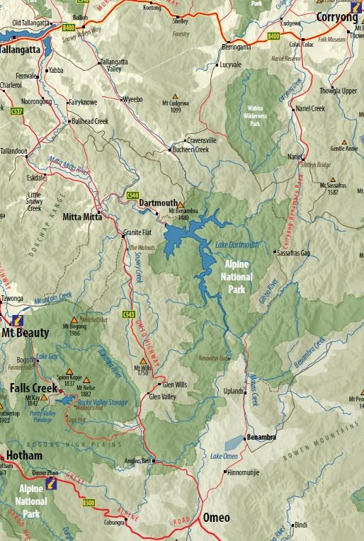
31 Dartmouth Region 69 The Walnuts This campground offers large, level Snowy Creek creekside sites which feature walnut trees providing good shade over short grass which is easily accessible from the Omeo Highway. Various sites are available either under the trees or creekside. Directions: From Mitta Mitta: South 13.6k up the Omeo Hwy [C543], on right after Snowy Cr bridge.
32
33 70 Snowy Creek Campground Situated on the Mitta Mitta River, Snowy Creek Campground provides two small, level, creekside camp areas. Light shade available and easy access to waterway for swimming and fishing. Directions: From Mitta Mitta: South 11.6k on Omeo Hwy, left (east) 0.7k down Holloways Rd (dry weather only, little gravel) to Snowy Creek. 71 Lighting Creek Campground Lighting Creek offers a pleasant maintained campground known for its cleanliness and quiet. Sites are provided along a large extended level creekside flat shaded by willows, wattles and/or gums and extends to another level upstream. Directions: 22k S from Mitta Mitta via Omeo Hwy [C543], on right over creek just before Lightning Creek bridge.

34
35 Upper Murray Reserves & Corryong Region 56 Jingellic Reserve Jingellic Reserve is a pleasant riverside camp situated on the river flats below Jingellic s Bridge Hotel. This popular campground features ample shade, maintained lawns, flush toilets, and a park-like atmosphere with easy access to the Hotel for meals and refreshments and the river for swimming, fishing and canoeing. Showers available for a fee. Directions: From Jingellic township travel east from the general store upriver about 1k on the River Rd (follow hotel signs), 100m past the pub turn right. 57 Neils Reserve Neils Reserve offers a large extended site over tiered gravel flats to a large river bend. It is well positioned beside the Murray River, between the small townships of Walwa and Tintaldra and offers secluded sites. Enjoy your favourite river-based activities such as fishing, swimming or canoeing. Located adjacent to Burrowa Pine Mountain National Park for nearby bushwalks. Directions: Access from Wodonga: East 56k on the Murray Valley Hwy [B400], left (north) 84k on the Murray River Rd [C546] (7k east of Walwa, 1.6k W of Eight Acres Rd junction). Signpost at entry gate 58 Clarke Lagoon Wildlife Reserve Clarke s Lagoon Wildlife Reserve offers many sites along the Murray River to enjoy river activities and leisurely camping. This wildlife reserve offers shady sites within a peaceful riverside setting. It is a popular destination over holiday periods. Easy access to the River for swimming, fishing and canoeing. Directions: This reserve is 6 km north of Tintaldra, off Murray River Rd. Signpost at entry gate.
36 59 Hinces Creek To reach Hinces Creek, follow Cudgewa North Rd past the Bluff Creek turn-off and veer into Hinces Creek Track. Up at the northern end of the national park is the monolithic Pine Mountain and its wondrous botany, which includes several types of grevillea and the phantom wattle. You can hike to the summit via a very strenuous 6 km walking track. Directions: From Cudgewa township, travel east along Cudgewa Valley Rd. Turn left onto Cudgewa North Rd. Continue along this road and turn left into Bluff Falls Rd and proceed to the Burrowa-Pine Mountain National Park then veer onto Hinces Creek Track. 60 Blue Gum Camp This is a small campground with ample shade. From here, walk the 2 km trail through blue gum forest to Bluff Falls, which are at their spectacular best in spring, or prepare for an attempt on the park s highest summit via the difficult 7.5 km Mt Burrowa Walking Track. Directions: From Cudgewa township, travel east along Cudgewa Valley Rd. Turn left onto Cudgewa North Rd. Continue along this road and turn left into Bluff Falls Rd and proceed to the Burrowa-Pine Mountain National Park entrance. Entrance to Blue Gum Camp is 1 km past Bluff Gum Camp. 61 Bluff Creek This is a small campground with ample shade. From here, walk the 2 km trail through blue gum forest to Bluff Falls, which are at their spectacular best in spring, or prepare for an attempt on the park s highest summit via the difficult 7.5 km Mt Burrowa Walking Track. Directions: From Cudgewa township, travel east along Cudgewa Valley Rd. Turn left onto Cudgewa North Rd. Continue along this road and turn left into Bluff Falls Rd and proceed to the Burrowa-Pine Mountain National Park entrance. Blue Gum Camp immediately over the entry ramp.
37 62 Indi Bridge Reserve Indi Bridge is one of many delightful small reserves scattered along the upper reaches of the stately Murray River. Fishing and birdwatching are just a couple of the leisurely activities enjoyed here. Easily accessed off the Upper Murray Rd, the reserve has been planted with quickly maturing shade trees and offers regularly maintained sites with frontage to the River. Directions: From Corryong travel east on Murray Valley Hwy, turn right towards Khancoban (B400 continued) over Towong Gap, turn right onto Upper Murray Rd and travel 9km and turn left into Indi Rd. Indi Bridge reserve immediately on your right. 63 Burrowye Reserve A large reserve on the banks of the Murray River, downstream of Walwa township. The Burrowye Reserve is adjacent to the densely treed Mt Lawson State Park the summit of the mountain at the centre of the park provides fantastic views of the surrounding region. Ample shade provided by white trunked Manna Gums, willow and wattle with significant river frontage and safe access to pebbly river beaches and water. Directions: Burrowye is 24 km west of Walwa, turning off Murray River Rd at the Burrowye Reserve signpost. 64 Nariel Creek Recreation Reserve This is a large camping area on the banks of the Nariel Creek offering many shaded sites. Extremely busy campsite between Christmas and 2 Jan when the annual, long-running Nariel Creek Folk Festival fills the reserve with the sounds of concerts and jam sessions. This creekside reserve is 12 km south of Corryong. Directions: Corryong Benambra Rd, which branches off the Murray Valley Hwy 7 km west of the town of Corryong. $
38 65 Gadds Reserve This very large, open and grassy campground is located on the banks of the Murray River west of Walwa township. Sheltered by willows the site has very limited facilities. Directions: Travel west of Walwa, turning off Murray River Rd at Gadds Reserve signpost via a short dirt track. 66 Stacey s Bridge The level ground at Stacey s Bridge is great for camping and there s plenty of shade. Wildlife is often encountered, in particular the local kangaroos. Stacey s Bridge campground is a quiet waterside spot at the head of the Nariel Valley, 46km south of Corryong. Swimming and fishing in the creek highlights. Directions: From Corryong, travel north towards Wodonga. Turn left onto Corryong Benambra Rd and tour 31km to the campground on both sides of the road. 67 Wheeler s Creek Wheelers Creek is a prime destination for 4WD tourers who ramble down a scenic stretch of Wheeler Creek Logging Rd to reach it. The area for campers has facilities that include Wheeler s Creek Hut, ample shade, toilets and picnic tables. As with other camping spots in Corryong District Forest, a 4WD is recommended for access as is advice on road conditions. Directions: 65km south of Corryong the site is accessed by following the Benambra Corryong Rd and turning onto Wheeler Creek Logging Rd.

39 68 Bunroy Creek This camground is located within Biggara Valley, to the south of Indi Bridge Reserve and on the edge of NSW s enormous Kosciuszko National Park. Bunroy Creek offers a number of small sheltered sites beside the upper reaches of the Murray River. It is popular with anglers, swimmers, canoeists and 4WD enthusiasts. Directions: From Corryong travel east on Murray Valley Hwy, turn right towards Khancoban (B400 continued) over Towong Gap, turn right onto Upper Murray Rd and travel 12km and turn right to Bunroy Rd. Follow to Bunroy Creek Track, turn left to the River.
40 Public Water Access Location Address Open Fee Albury Railway Place, Albury 24 hour access Free Corryong Corryong Salesyard Complex Donaldson Street, Corryong 24 hour access Free Oxley Reserve Oxley. 24 hour access Free
41 Rubbish Disposal Location Address Open Fee Albury Corryong Railway Place (skip at Atkins Street intersection), Albury Corryong Waste Disposal Sugarloaf Road, Corryong 24 hour access Free Tues & Thurs 4.00pm pm, Sat 8.00am - 12pm, Sun 12.00pm pm. Mansfield Mansfield Resource Recovery Centre Monkey Gully Road, Mansfield Mon 9.00am pm, Wed & Fri 12.00noon pm From $5.20 Mount Beauty Mount Beauty Transfer Station Maddisons Lane, Mount Beauty Tues-Thurs 10.00am pm, Sat & Sun 10.00am pm Wangaratta Wangaratta Transfer Station Sandford Road, Wangaratta Tues - Fri 9.00am pm, Sat & Sun 10.00am pm $1.20 Up to 30L Wodonga Wodonga Transfer Station, 29 Kane Road, Wodonga Mon - Fri 9.00am pm, Sat & Sun 10.00am pm $6.50 Up to 200L
42 Public Dump Points Location Address Open Fee Albury Railway Place, Albury 24 hour access Free Benalla Corowa Benalla Airport, Samaria Road, Benalla Rowers Park, Bridge Road, Corowa 24 hour access Free 24 hour access Free Corryong Donaldson Street (adjacent to saleyards), Corryong 24 hour access Free Mansfield Stock route (off Maroondah Hwy, 100m west of the Mansfield Visitor Information Centre) Daylight hours Free Myrtleford Holiday Park Lewis Avenue, Myrtleford Reception hours $5.00 Wangaratta Wodonga Painters Island Caravan Park Pinkerton Cres, Wangaratta Wodonga Caravan & Cabin Park 186 Melbourne Road, Wodonga Daylight hours $ am pm daily $5.00
43 Legend Sites suitable for tents Sites suitable for caravans Mobile phone service available (not necessarily on all networks) Camp fires permitted** Picnic tables available Fresh water available (may need treatment to make suitable for drinking) Toilets available (may be composting) Showers available (not excluding cold water) Dogs are permitted on leads Suitable area for fishing Walking tracks departing from campground/reserve Formal or informal boat ramp present Power is available $ A low cost fee is associated with camping at the site **Note: Whilst many of the campsites listed allow open fires, please be mindful that this is only outside of fire restriction periods. Always check the CFA website for current information on Fire Ban restrictions before heading to a campsite. Visit Alternatively, call the local Visitor Information Centre. Parklands and campsites may be closed during high risk flood and fire periods.
44 VISITOR INFORMATION CENTRES Albury Railway Place, Cnr Smollett & Young Streets, Albury, NSW visitalburywodonga.com Beechworth 103 Ford Street, Beechworth, Vic beechworthonline.com.au Benalla 14 Mair Street, Benalla, Vic benalla.vic.gov.au Bright 119 Gavan Street, Bright, Vic visitbrightandsurrounds.com.au Chiltern 30 Main Street, Chiltern, Vic chilternvic.com Corowa 100 Edward Street, Corowa, NSW visitcorowashire.com.au Corryong 50 Hanson Street, Corryong, Vic towong.vic.gov.au Mansfield 173 High Street, Mansfield, Vic mansfieldmtbuller.com.au Mount Beauty 31 Bogong High Plains Road, Mount Beauty, Vic visitmountbeauty.com.au Myrtleford Great Alpine Road, Myrtleford, Vic Rutherglen 57 Main Street, Rutherglen, Vic rutherglenvic.com Wangaratta Murphy Street, Wangaratta, Vic visitwangaratta.com.au Yackandandah 37 High Street, Yackandandah, Vic uniqueyackandandah.com.au Yarrawonga Mulwala Irvine Parade, Yarrawonga, Vic yarrawongamulwala.com.au Disclaimer: Every effort has been made to ensure the accuracy of this guide and maps. The Visitor Information Centres associated with its production accept no responsibility or liability for any omissions or incorrect information.
Warby Walkers Walks. January 1996 to December The walks are listed in alpha order followed by the grading of the walk(s),
,") Warby Walkers Walks January 1996 to December 2014 The walks are listed in alpha order followed by the grading of the walk(s), the date in YYYY.MM format and the general locality of the walk. Albury/Wodonga
Warby Walkers Walks January 1996 to December 2014 The walks are listed in alpha order followed by the grading of the walk(s), the date in YYYY.MM format and the general locality of the walk. Albury/Wodonga
WORDS BY LUKE ARNOLD, PHOTOGRAPHY BY MATT HAWKE
 Southern SECRETS The scenery, history and 4WDing of this lesser-known region of the Victorian High Country will blow you away WORDS BY LUKE ARNOLD, PHOTOGRAPHY BY MATT HAWKE 038 038-043 Sth Alpine.indd
Our Murray River Beaches
 Page 1 of 5 Our Murray River Beaches Click here to print this page West of Yarrawonga are many access points to the river. Earth tracks lead from the Murray Valley Highway through state forests to picnic
Out and about at Geehi
 Geehi Geehi Flats is a large area of flat floodplain on the banks of the Swampy Plains River. Located within Kosciuszko National Park, it is home to a popular campsite in summer for people wanting to enjoy
Cataloochee. Fishing Species Rainbow Trout and Brook Trout. Recreation
 Cataloochee River Information The Cataloochee River is located in the historic Cataloochee Valley--a relatively remote part of Smoky Mountain National Park. The campground is a secluded setting and offers
HOTEL WANGARATTA GATEWAY is
 The award-winning QUALITY HOTEL WANGARATTA GATEWAY is excellence on every level. Having recently undergone a major redevelopment and extension the AAA rated 4.5 star Gateway offers 77 suites and apartments,
Mt Kuring-gai Track to Berowra station
 Mt Kuring-gai Track to Berowra station 4 hrs 15 mins 9.7 km One way Hard track 4 553m This walk explores three valleys, with great displays of wild flowers in spring, and some nice sandstone overhangs.
Merritts Traverse. 1928m
 Merritts Traverse 3 hrs Hard track 5.8 km Circuit 4 167m This walk starts with a scenic journey to the top of the hill on the chairlift. Starting along Merritts Nature walk, this walk soon detours down
Victoria Falls and Grose Valley to Blackheath Station
 This walk explores a fantastic section of the Grose Valley. Starting above Victoria Falls, the walk explores the cascades before dropping into the valley for the first nights rest at Burra Korain campsite.
Tour de Murray to Mountains Pedal n Pamper
 Tour de Murray to Mountains Pedal n Pamper An iconic cycling tour The Murray to Mountains Rail Trail is an iconic cycling trail, that takes you back in time, but also through stunning scenery, farmland,
Rail Trail Gossip by Mike Lee (AKA Fat Controller)
") Rail Trail Gossip by Mike Lee (AKA Fat Controller) During the planning stages of travelling south for the Tour Down Under (reported elsewhere) I decided that I would extend my sojourn south for a week
Rail Trail Gossip by Mike Lee (AKA Fat Controller) During the planning stages of travelling south for the Tour Down Under (reported elsewhere) I decided that I would extend my sojourn south for a week
Trail Beginning Elevation: 7553 ft The Poison Creek Trailhead is located at the end of National Forest Road 646E (NF-646E).
.") West Mountain Trails Poison Creek Trail #134 Length: 2.9 miles (4.7 km) Difficulty Horseback: A good trail for the first time west mountain rider, some steep sections Hiking: Most Difficult USGS Maps:
West Mountain Trails Poison Creek Trail #134 Length: 2.9 miles (4.7 km) Difficulty Horseback: A good trail for the first time west mountain rider, some steep sections Hiking: Most Difficult USGS Maps:
Discover. Ashhurst Domain. Nature s Playground
 Discover Ashhurst Domain Nature s Playground Discover Step back into New Zealand, Aotearoa, of generations long gone. Discover lush natural surrounds echoing with rich birdsong in one of the Manawatu s
Berowra Waters to Cowan Station
 Berowra Waters to Cowan Station 3 hrs 30 mins 7.2 km One way Hard track 597m This is a hilly walk out of the beautiful Berowra Waters valley to Cowan Station. There are many wide views across Berowra Creek
Welcome to Dale Farm Rural Campsite
 Welcome to Dale Farm Rural Campsite Thank you for booking, we are very much looking forward to welcoming you to Dale Farm and the local area. Please read the following guide as it has important information
Prince Edward Island National Park of Canada
 Prince Edward Island National Park of Canada Things you should know regarding Cavendish and Stanhope Campgrounds Important Notices General Camping Information Fees If There is No Vacancy Require Additional
Crystal Lake Area Trails
 Lake Area Trails Welcome to the Lake area of the Big Snowy Mountains! This island mountain range in central Montana features peaks reaching to 8,600 feet and long, high ridges from which vistas of the
The Hume Workforce Development Committee
 The Hume Workforce Development Committee Hume Regional Development Australia Accommodation and Food Labour Market Snapshot Workforce Planning Australia March 2012 Workforce Planning Australia - www.workforceplanning.com.au
Guthega to Mt Twynam. 2183m. 1583m. 6 hrs 45 mins 14.8 km Return. Experienced only. 913m
 Guthega to Mt Twynam 6 hrs 45 mins 14.8 km Return Experienced only 5 913m This walk starts from Guthega and makes its way along the Snowy River to the Illawong Lodge, via the Blue Cow Creek flying fox.
Located in the northeastern part of WA, the Gibb River Road is ready for adventure. Photo: Aaron Schubert
 Australia has some world class camping destinations, and the Gibb River Road in the northern part of Western Australia is a prime example of this. Located in the Kimberley, the Gibb River Road is a spectacular
KETTLE CREEK CONSERVATION AUTHORITY TRAIL GUIDE.
 KETTLE CREEK CONSERVATION AUTHORITY TRAIL GUIDE www.kettlecreekconservation.on.ca EXPLORE OUR TRAILS HIKE OUR TRAILS Kettle Creek Conservation Authority (KCCA) proudly supports and promotes an active lifestyle
KEY. Physical Activity Levels. Low = Medium = Creative = High = Accommodation Types. = Camping (Tents) = Hard Top
 = Hard Top") Program Calendar July December 2018 KEY Physical Activity Levels Low = Medium = High = Creative = Accommodation Types = Camping (Tents) = Hard Top JULY Tuesday 5 Yarra River Walk - Ideal for new participants
Program Calendar July December 2018 KEY Physical Activity Levels Low = Medium = High = Creative = Accommodation Types = Camping (Tents) = Hard Top JULY Tuesday 5 Yarra River Walk - Ideal for new participants
Androscoggin River Trail Access Sites. North Woods. 168 miles from its source at Lake Umbagog to Merrymeeting Bay
 Androscoggin River Trail Access Sites North Woods 168 miles from its source at Lake Umbagog to Merrymeeting Bay Trail Under Construction More than 40 Public Access Sites Available Androscoggin River Watershed
ACCOMMODATION MOTELS UNITS/ROOMS RESTAURANT FEATURES
 MOTELS UNITS/ROOMS RESTAURANT FEATURES Avondel 4 Family No Licensed Function Room 21 Bridge Street, Benalla 9 Double Internet access T. 5762 3677 F. 5762 3943 4 Twin or triple Will allow pets www.avondelmotorinn.com
Congewai Track Head (East) to Watagan Headquarters
 to Watagan Headquarters") Congewai Track Head (East) to Watagan Headquarters 7 hrs Hard track 17.2 km One way 4 973m This full day walk starts from the Congewai valley trackhead (east) and follows the Great North Walk up into the
Congewai Track Head (East) to Watagan Headquarters 7 hrs Hard track 17.2 km One way 4 973m This full day walk starts from the Congewai valley trackhead (east) and follows the Great North Walk up into the
Countryside Trails Dunkeld
 R A N G E R S E RV I C E Countryside Trails Dunkeld WELCOME Welcome to this southern end of Atholl Estates. The countryside here is a wonderful blend of lochs, woodland and heather moor. There is a large
Abbotts Falls Walking Track
 Abbotts Falls Walking Track 3 hrs 7.3 km Circuit Hard track 329m This circuit takes you through both dry and moist forest, using a combination of walking trails and wider tracks. The side trip to the dammed
EAST COAST TASMANIA. Holiday Park Guide
 EAST COAST TASMANIA Holiday Park Guide Ansons Bay Mount William National Park & Campgrotund: 1.Deep Creek, Policemans Point 2.Stumpys Bay Campsite Toilet, table, BBQ, Rubbish (Tip on limited opening hours
Jerusalem Bay Track (Cowan to Brooklyn)
") Jerusalem Bay Track (Cowan to Brooklyn) 5 hrs 30 mins 13.4 km One way Hard track 4 654m This Cowan to Brooklyn Station walk is a popular section of the Great North Walk, with scenery ranging from foreshore
Jerusalem Bay Track (Cowan to Brooklyn) 5 hrs 30 mins 13.4 km One way Hard track 4 654m This Cowan to Brooklyn Station walk is a popular section of the Great North Walk, with scenery ranging from foreshore
Ambleside & Windermere Outdoor Properties Access Statement.
 Ambleside & Windermere Outdoor Properties Access Statement. Windermere, Cumbria. T: 015394 46402 E: ambleside@nationaltrust.org.uk please state that your email relates to access in Ambleside or Windermere.
Camping (Primitive) Camping (RV) Electrical Potable Water Grill Established Fire Pit Picnic Table
 Camping (RV) Electrical Potable Water Grill Established Fire Pit Picnic Table") Alden - 9th Road River Mile 777 Map: 38.20833, -98.32031 Managing Agency: Kansas Department of Wildlife, Parks & Tourism Nearest Community: Alden, Rice County Kansas Developed Amenities Provided Parking
Alden - 9th Road River Mile 777 Map: 38.20833, -98.32031 Managing Agency: Kansas Department of Wildlife, Parks & Tourism Nearest Community: Alden, Rice County Kansas Developed Amenities Provided Parking
A TOUR OF FLORA HOTSPOTS IN THE RIDDELLS CREEK AREA.
 A TOUR OF FLORA HOTSPOTS IN THE RIDDELLS CREEK AREA. Suggested one or two day tour from Melbourne to see the Flora and Nurseries of the Western Plains Grasslands, the Foothills of the Macedon Range and
Favourite campsites around New South Wales
 Favourite campsites around New South Wales These are some of our favourite campsites around New South Wales. We have selected a few from each region around the state of which we consider to be some of
Prince Edward Island National Park of Canada
 Prince Edward Island National Park of Canada Things you should know regarding Cavendish and Stanhope Campgrounds Updated October 20, 2017 Important Notices: Important Notices General Camping Information
Banff National Park of Canada
 Banff National Park of Canada Things you should know regarding Tunnel Mountain Village I and Tunnel Mountain Village II Campgrounds Updated July 13, 2012 Important Notices Important Notices General Campground
Ewen Maddock Dam RECREATION GUIDE
 Ewen Maddock Dam RECREATION GUIDE seqwater.com.au About Ewen Maddock Dam OUR VISION To manage access to recreation opportunities while protecting natural resources and water quality. Ewen Maddock Dam,
Willow Cottage on beach 10 minutes from Traverse City
 Willow Cottage on beach 10 minutes from Traverse City Summary Willow Cottage is one of 3 cottages that make up our small lakeside resort. It is located on 1.2 acres of land, with 70 ft of sandy Silver
Western Commission Track to Dubbo Gully
 This two day walk follows a series of historic roads along clear and wide management trails. This walk explores the great views from Western Commission Track, the sandstone handicraft on the Old Great
Maine RV Parks and Campgrounds
 1 Maine RV Parks and Campgrounds Wilderness Edge Campground Brief Description: We are located in the heart of Moose country just minutes from Baxter State Park, Mt. Katahdin, and The Katahdin Woods & Waters
Staples Lookout to Mt Wondabyne loop
 Staples Lookout to Mt Wondabyne loop 4 hrs 3 mins 1.8 km Circuit Hard track 337m This walk starts and finishes at Staples Lookout, on Woy Woy Rd. The walk follows sections of the Great North Walk around
Victoria Falls Lookout to Blue Gum Forest
 Victoria Falls Lookout to Blue Gum Forest 8 hrs Experienced only 13.8 km One way 5 112m This long day-walk follows a remote track down from Victoria Falls lookout, passing the waterfall, and into the Grose
Ohio RV Parks and Campgrounds. Shadow Lake RV Park. Loveberrys Funny Farm Campgound. Amenities
 1 Ohio RV Parks and Campgrounds Shadow Lake RV Park Brief Description: If you are looking for a park off the beaten path, out in the middle of nowhere then we are it. Settled within the rolling hills of
Getting there and away
 It s a case of brawn vs. beauty with these two Victorian mountains. Mt Bogong is the state s highest peak while Mt Feathertop is one of the prettiest, and quite unlike the others in its sharp, rugged formation.
CAMPING IN WESTERN AUSTRALIA
 CAMPING IN WESTERN AUSTRALIA CAMPSITES, REST AREAS, CARAVAN PARKS, DAY USE SITES AND CAMP GROUNDS PART 2 of 4 : PERTH PORT HEDLAND GREAT NORTHERN HIGHWAY IS THERE SOMETHING HERE THAT NEEDS UPDATING? IF
Victoria Falls to Blackheath Station
 Victoria Falls to Blackheath Station 2 Days Experienced only 22.2 km One way 5 1561m This is a fantastic overnight walk with a sleep in Acacia Flats camping area. The Grose Valley, with its views of the
Kitimat. Pacific Inland Coast. Hiking Guide Kitimat, British Columbia, Canada
 Kitimat Pacific Inland Coast Hiking Guide Kitimat, British Columbia, Canada 2010-2011 Sites and Trails Emergency Call 911 Police - Fire - Medical 2 Welcome to Kitimat This information was produced to assist
Le Moulin Du Buret (Mill House)
") Le Moulin Du Buret (Mill House) Summary 18th C Water Mill fully restored as holiday accommodation. Peaceful and private rural setting with extensive lawns and gardens. Full facilities, near small town.
Le Moulin Du Buret (Mill House) Summary 18th C Water Mill fully restored as holiday accommodation. Peaceful and private rural setting with extensive lawns and gardens. Full facilities, near small town.
Maple Grove, beach home 10 min. to Traverse City, 20 min. to Sleeping Bear
 Maple Grove, beach home 10 min. to Traverse City, 20 min. to Sleeping Bear Summary Sandy beach, 3 bdrm, 2 bath, fireplace, central air, WiFi, 10 minutes to Traverse City, 20 minutes from Sleeping Bear
Victoria Falls and Grose Valley to Blackheath Station
 Victoria Falls and Grose Valley to Blackheath Station 3 Days Experienced only 22.5 km One way 5 158m This walk explores a fantastic section of the Grose Valley. Starting above Victoria Falls, the walk
Difficult Run Stream Valley Park
 Difficult Run Stream Valley Park The more intense mountain bikers have known about for Difficult Run for some time. Equestrians have known it longer. Eight miles of unpaved trail, the Rails to River Trail
EAST COAST TASMANIA. Holiday Park Guide
 EAST COAST TASMANIA Holiday Park Guide Ansons Bay Mount William National Park & Campgrotund: 1.Deep Creek 2.Stumpys Bay Campsite Toilet, table, BBQ, Rubbish (Tip on limited opening hours but not at campsites),
A dam good time [ RESORT REVIEW ] RONDEBERG HOLIDAY RESORT, WESTERN CAPE. Words & pictures by FRANCOIS HUYSAMEN. 36 Caravan & Outdoor Life Magazine
![A dam good time [ RESORT REVIEW ] RONDEBERG HOLIDAY RESORT, WESTERN CAPE. Words & pictures by FRANCOIS HUYSAMEN. 36 Caravan & Outdoor Life Magazine](/thumbs/80/81792613.jpg "A dam good time [ RESORT REVIEW ] RONDEBERG HOLIDAY RESORT, WESTERN CAPE. Words & pictures by FRANCOIS HUYSAMEN. 36 Caravan & Outdoor Life Magazine") A dam good time [ RESORT REVIEW ] RONDEBERG HOLIDAY RESORT, WESTERN CAPE Words & pictures by FRANCOIS HUYSAMEN 36 Caravan & Outdoor Life Magazine Resort review - Rondeberg.indd 36 2017/04/12 3:09 PM RESORT
A dam good time [ RESORT REVIEW ] RONDEBERG HOLIDAY RESORT, WESTERN CAPE Words & pictures by FRANCOIS HUYSAMEN 36 Caravan & Outdoor Life Magazine Resort review - Rondeberg.indd 36 2017/04/12 3:09 PM RESORT
Carnarvon Station Reserve, Qld Camping Information
 Carnarvon Station Reserve. Photo: Katrina Blake Carnarvon Station Reserve, Qld Camping Information Quick facts Acquired: 2001 Area: 59,000 ha Traditional owners: Bidjara Location: Central Highlands region,
Split Point Lighthouse Aires Inlet
 www.greatoceanroad.vc Great Ocean Road Three Day Tour 2 Night Stay This three day trip of approximately 730 kilometre starts from Melbourne and provides a good overview of features along the Great Ocean
KEY. Physical Activity Levels. Low Medium High
 Program Calendar July December 2017 Physical Activity Levels KEY Low Medium High Seq = Sequential The sequential program provides participants with a different medium for learning and developing skills
ROBERTS CREEK PROVINCIAL PARK MASTER PLAN. November, 1981
 Ministry of Lands, Parks and Housing Parks and Outdoor Recreation Division Park Operations Branch North Vancouver, B. C. ROBERTS CREEK PROVINCIAL PARK MASTER PLAN November, 1981 Mr. G. Trachuk Director
Blackheath to Blue Gum loop
 Blackheath to Blue Gum loop 2 Days Hard track 24.1 km Circuit 4 1335m This walk is great for fit people getting into overnight walking, with its fantastic scenery and nostalgia as a classic overnighter.
Michigan RV Parks and Campgrounds. Leisure Time Campground. Way Back In Campground. Tawas River RV Park. Amenities
 1 Michigan RV Parks and Campgrounds Leisure Time Campground Amenities Brief Description: e are 90 miles NW of Grand Rapids, & 40 miles NE of Ludington. We are in the heart of the Manistee National Forest.
CAMPING IN WESTERN AUSTRALIA
 CAMPING IN WESTERN AUSTRALIA CAMPSITES, REST AREAS, CARAVAN PARKS, DAY USE SITES AND CAMP GROUNDS PART 3 of 4 : PORT HEDLAND KUNUNURRA - GREAT NORTHERN HIGHWAY IS THERE SOMETHING HERE THAT NEEDS UPDATING?
ANAGEMENT. LAN November, 1996
 M ANAGEMENT P LAN November, 1996 for Paul Lake Provincial Park Ministry of Environment, Lands and Parks BC Parks Department Paul Lake Provincial Park M ANAGEMENT P LAN Prepared by BC Parks Kamloops Area
1. Wolgan Valley (Newnes):
:") Friday is here again and it feels like the day is dragging on forever. You need a holiday, but you don t have the leave or can t afford to take time off. Well, my family and I have mastered the art of the
Friday is here again and it feels like the day is dragging on forever. You need a holiday, but you don t have the leave or can t afford to take time off. Well, my family and I have mastered the art of the
NOHOANGA SITE INFORMATION SHEET TUCKERS BEACH, OTAGO. Tuckers Beach Road. Entry Point to Site. Getting there
 NOHOANGA SITE INFORMATION SHEET TUCKERS BEACH, OTAGO Getting there This site is within the Tuckers Beach Wildlife Reserve, at approximately 280 Tuckers Beach Road, 15mins drive north of Queenstown township.
Banff National Park of Canada Lake Louise
 Banff National Park of Canada Lake Louise Things you should know regarding Lake Louise Hard- Sided and Soft-Sided Trailer/Tent Campgrounds Updated September 12, 2017 Important Notices: Important Notices
Weston County, Wyoming
 The Sweet 200-Acre Property Weston County, Wyoming A unique opportunity to own a little piece of the old West, where one can experience unparalleled scenery, adventure and history walk in the footsteps
Campsite Information 2018
 Campsite Information 2018 Main Road, Grendon, Northants, NN7 1JW 01933 665303 www.grendonlakes.co.uk info@grendonlakes.co.uk W E L C O M E Our campsite provides a beautiful part of Central Northamptonshire
Podcast 31 - The Australian Alps - A Trip to Thredbo
 Podcast 31 - The Australian Alps - A Trip to Thredbo by Rob McCormack - Friday, January 03, 2014 http://slowenglish.info/?p=918 Learn English while learning about daily life in Australia, with Rob McCormack
Main Range Track - Loop from Charlotte Pass camping near Mt Townsend
 Main Range Track - Loop from Charlotte Pass camping near Mt Townsend 2 Days Experienced only 27.7 km Circuit 5 1260m This great overnight walk starts from Charlotte Pass and provides access to some of
Kakadu Highlights No. 9: September 23 - October 6, 2018
 Kakadu Highlights No. 9: September 23 - October 6, 2018 Section 1: Barramundi Creek: September 23-26 We begin with a four to six hour, 350 kilometre drive from Darwin. The last 45 kilometres is on a 4WD
Oklahoma RV Parks and Campgrounds
 1 Oklahoma RV Parks and Campgrounds Rolling Stone Stables and RV Park Brief Description: Rolling Stone Stables and RV park is an 80 acre horse farm and RV park. We are located just 2 miles from I-40 for
Illawarra Escarpment State Conservation Area Walking Tracks
 Illawarra Escarpment State Conservation Area Walking Tracks NPWS Illawarra Area Office Ground Floor, Government Office Block 84 Crown Street Wollongong NSW 2500 02 4223 3000 (Mon-Fri) Royal National Park
Leura Cascades to Gordon Falls Reserve
 Leura Cascades to Gordon Falls Reserve 1 hr 15 mins 1.8 km One way Moderate track 200m From Leura Park to Gordon Falls Park, this diverse walk offers fantastic views of the Jamison Valley, as well as two
Ombined End of Year Ride with Morning Tea at King River Cafe Oxley
 December, 2015 Western Australia Trip - October, 2015 Thanks to Kate and Graham s well named Ultimate home away from home, Graham s and my trip to the west was comfortable and well organised. We travelled
Listing of Campsites on the Manigotagan River
 Listing of Campsites on the Manigotagan River This document lists and describes the campsites along the Manigotagan River between Highway #314 and the government dock in the community of Manigotagan. The
GOLDEN EARS PROVINCIAL PARK
 GOLDEN EARS PROVINCIAL PARK Trail Information as of October 10 th 2015 Do not underestimate the mountainous wilderness of Golden Ears Provincial Park. The combination of rugged terrain and rapidly changing
AOTA ArtTrek Locations
 AOTA ArtTrek Locations ArtTrek is a summer-long Grand County, CO art adventure. Highlighted by snow-covered mountain vistas and rolling meadows threaded with sparkling streams and rivers, numerous sites
FAMILY CAMPING. Visitor Guide. Issue 11/May Conservation Areas BRUCEDALE DURHAM McBEATH SAUGEEN BLUFFS.
 FAMILY CAMPING Visitor Guide Issue 11/May 2015 Conservation Areas BRUCEDALE DURHAM McBEATH SAUGEEN BLUFFS www.svca.on.ca Administration Office 1078 Bruce Rd. 12, P.O. Box 150, Formosa ON N0G 1W0 Tel: 519-367-3040
Berowra to Cowan via Berowra Waters
 Berowra to Cowan via Berowra Waters 6 hrs Hard track 12.9 km One way 4 884m With train station at each end this walk explores the ridges and valleys around Berowra Waters. There are plenty of excellent
Aira Force & Ullswater Access Statement
 Aira Force & Ullswater Access Statement Aira Force, Watermillock, Penrith, CA11 0JS T: 017684 82067 E: ullswater@nationaltrust.org.uk Section 1: Aira Force Section 2: Ullswater Countryside Section 1: Aira
TREK THE ROCKIES ABOUT THE CHALLENGE TREK THE ROCKIES FOR HIGHLAND HOSPICE CANADA TREK DEMANDING
 TREK THE ROCKIES CANADA TREK DEMANDING ABOUT THE CHALLENGE The Canadian Rockies are justifiably world-famous for their magnificent scenery: the combination of impressive, jagged mountains, bright turquoise
Gibberagong Track. 169m
 Gibberagong Track 2 hrs 30 mins 6.5 km One way Hard track 4 180m Starting in suburban Wahroonga, this wellmaintained track follows Cockle Creek down to Bobbin Head in the Ku-ring-gai Chase National Park.
THURSDAY 9 - WEST END TO SOUTH BANK
 MARCH WEDNESDAY 1 st 10 am INNER CITY PARKS WALK This walk takes in many of the inner city s parks and includes many significant trees. Distance 6 km some steps and uphill walking Meet Anzac Square, Adelaide
Whitsundays to Darwin
 Whitsundays to Darwin 2018 Day 1 WHITSUNDAYS Day 4 THE GULF Day 8 KAKADU Day 1 WHITSUNDAYS Day 2 UNDARA Day 3 COBBOLD GORGE or FORSAYTH Day 1 Arrive Airlie Beach Welcome to the Whitsundays! Soak up the
Location: Height: Access: Distance: Elevation: Season: Difficulty: Lat/Long: Directions:
 Upper Eagle Falls Upper Eagle Falls (~20 ft.) is a short hike up from the roadside at the Eagle Falls picnic area. It is very difficult to get a parking spot here during the day, so it is recommended to
South Dakota RV Parks and Campgrounds. Three Flags RV Park and Camp. Hills RV Park BROKEN ARROW CAMPGROUND. Amenities
 1 South Dakota RV Parks and Campgrounds Three Flags RV Park and Camp Brief Description: Large pull thru RV sites 30' wide by 80' long. Park offers coin laundry, free cable TV with full hookups, free WiFi,
Lake Baroon RECREATION GUIDE
 Lake Baroon RECREATION GUIDE seqwater.com.au About Lake Baroon OUR VISION To manage access to recreation opportunities while protecting natural resources and water quality. Lake Baroon, located between
Tiger Mountain State Forest:
 98 60 hikes within 60 miles: SEATTLE 20 Tiger Mountain State Forest: West Tiger Mountain Three Loop i KEY AT-A-GLANCE INFORMATION Length: 5.1 miles round-trip Configuration: Loop Difficulty: Moderate difficult
Asheville & WNC Hikes
 Asheville & WNC Hikes Amazingly, we have 3,000+ miles of free public hiking trails near Asheville, including 1,600 miles in the Pisgah and Nantahala National Forests, 850 miles in Great Smokey Mountains
South Dakota RV Parks and Campgrounds
 1 South Dakota RV Parks and Campgrounds Three Flags RV Park and Camp Brief Description: Large pull thru RV sites 30' wide by 80' long. Park offers coin laundry, free cable TV with full hookups, free WiFi,
Crosslands to Berowra Waters return
 Crosslands to Berowra Waters return 6 hrs Hard track 13.7 km Return 4 1005m This return walk starts from the Crosslands Reserve and follows the Great North Walk along Berowra creek. The walk includes some
The striking colours of the setting sun reflecting on the waters is how Crimson Lake received its name. Crimson Lake Provincial Park is a meeting
 The striking colours of the setting sun reflecting on the waters is how Crimson Lake received its name. Crimson Lake Provincial Park is a meeting place of foothills forests in the west, bog and muskeg
Crosslands to Cowan. 220m
 Crosslands to Cowan 7 hrs 30 mins 14 km One way Hard track 4 1103m This section of the Great North Walk starts from the Crosslands camping area and winds north alongside Berowra creek, passing through
About Us Join the team! Calendar County Map FPPC Forms SPECIAL ALERTS CONTACT US!
 About Us Join the team! Calendar County Map FPPC Forms SPECIAL ALERTS CONTACT US! Search.. Home Reservations Parks Nature Centers Recreation Historic Sites Trails Lake Cahuilla Home Riverside County Parks
Erskine Creek via Pisgah Rock and Jack Evans
 Erskine Creek via Pisgah Rock and Jack Evans 4 hrs 30 mins 7.1 km Circuit Very experienced only 6 421m This walk visits some great lookouts and explores the lower section of Erskine Creek. Most of the
GIFFORD PINCHOT NATIONAL FOREST
 GIFFORD PINCHOT NATIONAL FOREST 9341 Wright Meadow 93 Spencer Meadow Spencer Butte 4247' 30 30A 19 24 80 31C Lewis River Lower Falls 5 Quartz Creek 90 Taidnapam Falls Upper Falls 31 Spencer Peak 3861'
Riding Mountain National Park of Canada
 Riding Mountain National Park of Canada Things you should know regarding the otentiks and the Yurt and Equipped Camping in the Wasagaming Campground Important Notices General otentik and Yurt Information
Lane Poole Reserve, Dwellingup Prospectus
 Lane Poole Reserve, Dwellingup Prospectus Connecting people to parks WA Parks Foundation Lane Poole Reserve Prospectus Waking up to the sounds of the bush, the smell of the coals in the campfire and the
Girrakool to Wondabyne station
 Girrakool to Wondabyne station 4 hrs Hard track 9.5 km One way 4 438m This walk starts from the Girrakool picnic area and winds south, through the Brisbane Waters National Park. The walk crosses some long
TAYLOR CANYON RANCH COLORADO - ROUTT COUNTY - STEAMBOAT SPRINGS
 TAYLOR CANYON RANCH COLORADO - ROUTT COUNTY - STEAMBOAT SPRINGS Tucked up against the steep valley shaped by Mt. Pau and rising to the Routt National Forest, Taylor Canyon Ranch is an easily accessible,
Blue Ridge Hiking Club - First Quarter 2018 Hikes
 Blue Ridge Hiking Club - First Quarter 2018 Hikes Monday, Jan 1: Trout Lake to Manor House & Figure 8 Trail: Meet at Trout Lake parking lot, at 9:30. (1st exit left off Parkway just south of Cone Manor
U.S. National Forest Campground Guide
 U.S. National Forest Campground Guide Southwestern Region Arizona, New Mexico, Oklahoma and Texas National Forests and Grasslands in the Southwestern Region NF = National Forest NG = National Grassland