ROBERTS CREEK PROVINCIAL PARK MASTER PLAN. November, 1981
|
|
|
- Osborne Blankenship
- 5 years ago
- Views:
Transcription
1
2 Ministry of Lands, Parks and Housing Parks and Outdoor Recreation Division Park Operations Branch North Vancouver, B. C. ROBERTS CREEK PROVINCIAL PARK MASTER PLAN November, 1981
3 Mr. G. Trachuk Director Planning and Research Branch Parks & Outdoor Recreation Division Victoria, B.C. Mr. J.C. Leman Regional Director Lower Mainland Region Parks & Outdoor Recreation Div. North Vancouver, B.C. This Master Plan for Roberts Creek Provincial Park is submitted for your approval
4 TABLE OF CONTENTS Page A. INTRODUCTION BACKGROUND EXISTING DEVELOPMENT PARK USE DEMAND...8 B. STATEMENT OF PURPOSE...9 C. PARK RESOURCES STATEMENT...10 D. ZONING...12 E. GENERAL MANAGEMENT STATEMENT...13 F. SPECIFIC MANAGEMENT PLANS...13 G. PLAN IMPLEMENTATION STRATEGY...15 APPENDIX: HIGHWAY TRAFFIC VOLUMES JULY-AUGUST i
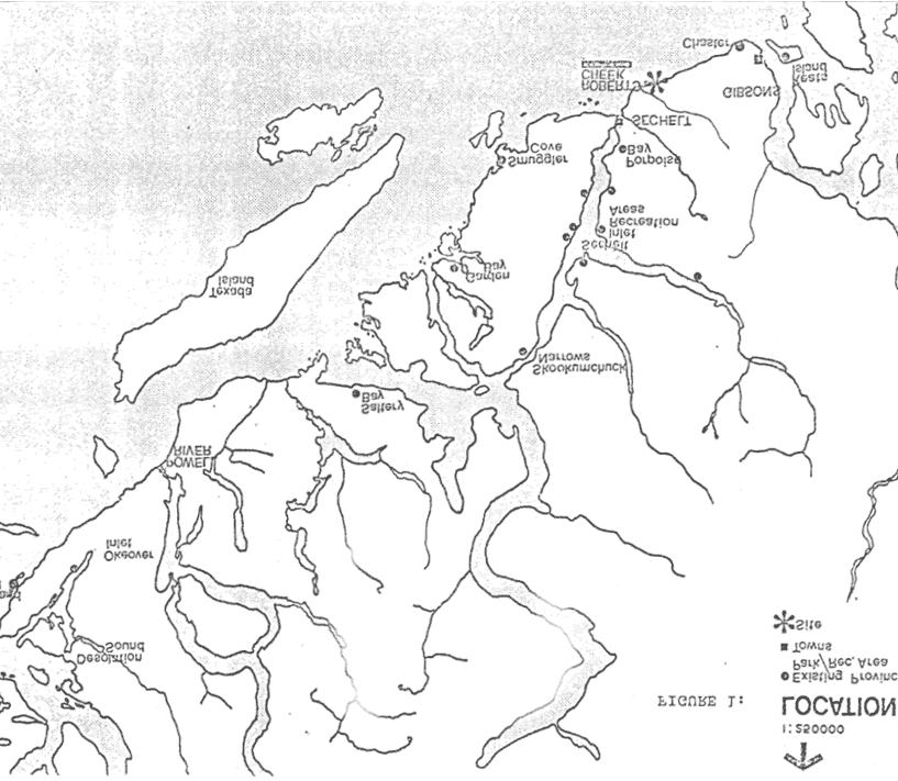
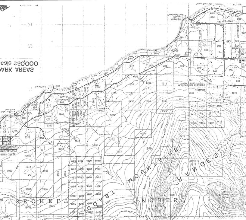
5 LIST OF FIGURES Figure Page 1 LOCATION MAP PARK AREAS MAP CAMPGROUND EXISTING FEATURES AND DEVELOPMENT PLAN DAY USE AREA EXISTING FEATURES AND DEVELOPMENT PLAN PROPOSED DEVELOPMENT PLAN...14
6 1 A. INTRODUCTION Roberts Creek Provincial Park, Class 'A', Category 6, is situated on the Sunshine Coast 10 kilometres west of Gibsons and approximately 55 kilometres north of Vancouver (Figure 1). The park consists of two separate areas (Figure 2) located about 1 kilometre apart. Access from Vancouver to both areas is via the Horseshoe Bay/Langdale ferry, then north along Highway 101. There are several other Provincial Parks in the area, the largest developed one being Porpoise Bay, covering over 60 hectares. 1. BACKGROUND Roberts Creek Provincial Park is named after the adjacent small community. The origin of the name came from the first settler, Frank Roberts, who homesteaded at the mouth of Roberts Creek in By 1880, all of the waterfront land around Gibson's Landing had been pre-empted, so Roberts travelled from Gower Point along the coast to the first suitable and available piece of shore front. Soon, many other settlers came to the area and established a community. The Union Steamship Company made frequent stops at Roberts Creek as part of its regular run up the coast. The park itself was designated firstly as a Class 'C' Provincial Park in 1947, when the waterfront area was developed for picnicking and day use after many years of unmanaged recreational use. The campground was combined with the day use area seven years later, and both were designated a Class 'A' Provincial Park in In 1975, a Sub-Regional Systems Plan for the Sunshine Coast identified Roberts Creek as an important day use/camping park in the area and suggested that the day use area be developed for boat launching.
7
8
9 4 2. EXISTING DEVELOPMENT The present park development (Figures 3 and 4) covers two separate areas and includes 25 campsites and day use parking for approximately 14 vehicles. DAY USE AREA The day use area fronts a small cobble beach which at lower tides reveals several patches of sandy beach that visitors utilize. The backshore consists of gently sloping grass areas with gravel picnicking terraces and off to the side, hidden amongst the trees, are the pit toilets. A small vehicle turnaround near the beach adjacent to the park boundary provides cartop boat launching. Unfortunately, site conditions prevent development of a major ramp boat launch site. CAMPGROUND The campground lies adjacent to the highway in a dense Coastal Douglas fir forest. Across the highway from the campground entrance is a Type I information shelter/pull-off, with parking for 8 cars. Off to the side of the entrance road is a small service yard/workshop, while on the opposite side is the sani-station. The campground is equipped with all the essential services, including water, pit toilets, and wood. Each campsite is visually well contained and very private. There are no organized trails in the park. On the south side of the campground, there is a pedestrian access through a housing sub-division that leads to the day use area about 1 kilometre to the south. However, most people drive down. Parkland on the north side of Highway 101 has not been developed except for the vehicle pull-out.
10
11
12 7 3. PARK USE The number of campers visiting Roberts Creek Provincial Park has varied considerably over the years. A major ferry fare increase in 1976 reduced ferry traffic volumes by 25% and adversely affected the campground attendance. It was not until two years later that ferry traffic was back up to normal levels and park attendance up accordingly. Over the past few years, there has been a steady increase in use of about 5% annually and in 1979, the campground reached peak capacity on 10 separate occasions. There is no recorded data for day use attendance; however, observations by field staff indicate a very heavy weekend use by the local community. Roberts Creek is one of the few major waterfront accesses in the area.
13 8 4. DEMAND Recreation is a significant factor in the future development of the Sunshine Coast. Four of the five goals of the Sunshine Coast Regional District's 1979 Regional Plan relate specifically to the enhancement of recreational potential of the Region. There are 21 policy statements within these goals and almost one third of these policies relate to the scenic and recreational values of the area; the protection of natural areas to maintain the beauty of the Region; and the provision of areas for recreational vehicle and recreational cottage accommodation. Area development policies provide for "tourist commercial areas" and "recreation areas". The recreational areas include Parks and Greenbelt areas. There is an increase in annual visitation to the Sunshine Coast from 1972 to 1980 (appendix), with the summer vacation months showing the greatest increase in traffic volumes. Annual increments in traffic are projected to continue at 6% to 10% according to the B. C. Ferry Corporation. Throughout the Sunshine Coast, there are 175 private campsites, with another 60 private campsites being constructed at Wilson Creek, 3 kilometres north of Roberts Creek. The Parks and Outdoor Recreation Division provides 111 campsites, with the only other future campground development planned at Garden Bay (50 campsites). Thus, the dominant number of private sector campsites and the development of more private facilities at Wilson Creek appears to reflect a high demand and a healthy campground industry. As far as Roberts Creek is concerned, although it has a 50% average seasonal occupancy and steady annual increases, the demand for camping opportunities there is expected to level off, given the aforementioned conditions and the ability of other private campgrounds to provide adequate opportunities. The day use area, on the other hand, is fully developed and unable to meet future demand for waterside recreational opportunities which may be brought about by further upland subdivision and campground development.
14 9 B. STATEMENT OF PURPOSE It is the purpose of the Parks and Outdoor Recreation Division, in cooperation with the Sunshine Coast Regional District and other Provincial and Federal agencies, to provide a diverse recreation system offering varied outdoor opportunities for both tourists and local residents on the Sunshine Coast. As such, the primary goal of Roberts Creek Provincial Park is to encourage and provide both transient camping opportunities in a scenic forest environment for visitors to the Sunshine Coast and day use/picnicking opportunities in a marine setting for the surrounding residents. Roberts Creek Park will be managed to provide this intensive recreational use in a manner consistent with the sheltered and tranquil atmosphere.
15 C. PARK RESOURCES STATEMENT Roberts Creek lies within the Coastal Douglas Fir biogeoclimatic zone. The thick vegetation in the campground is primarily Douglas fir and cedar, with a sword fern and salal understory. PHOTOGRAPH NOT AVAILABLE The area north of the highway and beyond the information shelter is similar in vegetation cover but considerably wetter and contains a number of moss species. PHOTOGRAPH NOT AVAILABLE The upland and marine component of the park combine to provide a variety of wildlife habitats. Deer and small mammals such as raccoons and squirrels are observed along with the occasional Bald Eagle and Osprey siting. Offshore, whales, seals and various duck species have been seen. A variety of invertebrate life such as sea stars, mussels and oysters can be found at low tide along the beach.
16 The day use area has intensive landscaping, which was developed well before park establishment. Included are many ornamental shrubs and grassy slopes. PHOTOGRAPH NOT AVAILABLE PHOTOGRAPH NOT AVAILABLE The beach frontage in the day use area is covered with large, smooth cobbles and large sections of driftwood, representative of longitudinal beach processes. The park resources appear in good condition and do not require modification.
17 12 D. ZONING The day use and campground sections of Roberts Creek Park are limited in area and are heavily used, subsequently both are entirely zoned Develoment. The Development Zone includes the area where construction of facilities is necessary to enhance or enable public recreation for camping, picnicking, hiking and viewing.
18 13 E. GENERAL MANAGEMENT STATEMENT Overall management of Roberts Creek Provincial Park will come under the Garibaldi District office, with specific park management procedures emanating from the local office at Porpoise Bay Provincial Park. F. SPECIFIC MANAGEMENT PLANS 1. RESOURCE MANAGEMENT PLAN Resource management will involve normal maintenance of the natural areas within the park for visitor observation and enjoyment. The foreshore is not included within the park boundary and does not appear to require increased protection. 2. VISITOR MANAGEMENT PLAN In general terms, Roberts Creek, for the moment, has been fully developed and will remain at current levels (25 campsites); however, the potential maximum is 40 campsites. Unless camping continues to grow in this area, with no resultant increase in private sector growth, no major additional facilities will be developed. Use and demand will be monitored to determine future expansion. 3. INTERPRETATION PLAN Although the interpretation potential is low, the existing situation should be improved. A small amphitheatre at the campground (Figure 6) consisting of a few logs would be adequate to provide a central focus for interpretation talks. The information shelter on the highway will detail park and recreation opportunities on the Sunshine Coast. 4. ADMINISTRATION PLAN The administration of this park will be based at Porpoise Bay Provincial Park, with normal management practices implemented.
19
20 15 G. PLAN IMPLEMENTATION STRATEGY Given the current and projected use and development in this park, only one stage of implementation is necessary. PHASE 1 1. Development of small gathering area (amphitheatre) at the campground.
21 APPENDIX HIGHWAY TRAFFIC VOLUMES JULY-AUGUST STATION Port Mellon Road 0.8 km north of Langdale Ferry km north of Ministry of Highways yard at Gibsons km north of Elementary School at Sechelt km north of Lang Bay Road at Lang Bay
ADDENDA. 1. It does not conform to the Master Plan format in the following areas: Statement of Purpose - clarification of parks purpose in system.
 File: 2-7-2-79-27 ADDENDA Plan for Saltery Bay Park This plan has been reviewed and is approved with the following comments and conditions: 1. It does not conform to the Master Plan format in the following
PLUMPER COVE MARINE PARK MASTER PLAN
 Lower Mainland Region Park Operations Branch Parks and Outdoor Recreation Division Ministry of Lands, Parks and Housing North Vancouver, B.C. PLUMPER COVE MARINE PARK MASTER PLAN DECEMBER, 1980 PLUMPER
ANAGEMENT. LAN November, 1996
 M ANAGEMENT P LAN November, 1996 for Paul Lake Provincial Park Ministry of Environment, Lands and Parks BC Parks Department Paul Lake Provincial Park M ANAGEMENT P LAN Prepared by BC Parks Kamloops Area
MONTAGUE HARBOUR MARINE PROVINCIAL PARK
 MONTAGUE HARBOUR MARINE PROVINCIAL PARK PURPOSE STATEMENT AND ZONING PLAN March 2003 1 MONTAGUE HARBOUR MARINE PROVINCIAL PARK Purpose Statement and Zoning Plan Primary Role The primary role of Montague
MARBLE RIVER PROVINCIAL PARK
 MARBLE RIVER PROVINCIAL PARK PURPOSE STATEMENT AND ZONING PLAN March 2003 MARBLE RIVER PROVINCIAL PARK Purpose Statement and Zoning Plan Primary Role The primary role of Marble River Park is to protect
MAIN LAKE PROVINCIAL PARK
 MAIN LAKE PROVINCIAL PARK PURPOSE STATEMENT AND ZONING PLAN March 2003 MAIN LAKE PROVINCIAL PARK Purpose Statement and Zoning Plan Primary Role The primary role of Main Lake Park is to protect a biologically
10.7 Acre Oceanfront North Rendezvous Island
 10.7 Acre Oceanfront North Rendezvous Island Jamie Zroback jamie@landquest.com 1 (604) 483-1605 Jason Zroback jason@landquest.com 1 (604) 414-5577 The Source for Oceanfront, Lakefront, Islands, Ranches,
TABLE OF CONTENTS. B. STATEMENT OF PURPOSE 8 1. Park Objectives 8 2. Manageme nt Philosophy 8
 TABLE OF CONTENTS Page A. INTRODUCTION 1 1. Setting 1 2. Regional Perspective 1 3. Present Development and Use 3 4. Land Status and Access 4 5. Demand 6 6. Purpose of Master Plan 7 B. STATEMENT OF PURPOSE
ANAGEMENT. LAN November, 1996
 M ANAGEMENT P LAN November, 1996 for Coldwater River Provincial Park Ministry of Environment, Lands and Parks BC Parks Department Coldwater River Provincial Park M ANAGEMENT P LAN Prepared by BC Parks
Watchorn Provincial Park. Management Plan
 Watchorn Provincial Park Management Plan 2 Watchorn Provincial Park Table of Contents 1. Introduction... 3 2. Park History... 3 3. Park Attributes... 3 3.1 Natural... 4 3.2 Recreational... 4 3.3 Additional
Marchand Provincial Park. Management Plan
 Marchand Provincial Park Management Plan 2 Marchand Provincial Park Table of Contents 1. Introduction... 3 2. Park History... 3 3. Park Attributes... 4 3.1 Natural... 4 3.2 Recreational... 4 3.3 Additional
Port Bruce. Interim Management Statement
 Port Bruce Interim Management Statement Port Bruce Interim Management Statement August 3, 1999 This Port Bruce Provincial Park Interim Management Statement provides direction for the custodial management
Access: The rocky shoreline is only accessible via private property.
 10. Whale Cove Site description: Whale Cove is a small cove fringed by private homes and condominiums with diverse and relatively undisturbed rocky intertidal and subtidal habitat located approximately
SPECTACLE LAKE PROVINCIAL PARK PURPOSE STATEMENT AND ZONING PLAN
 SPECTACLE LAKE PROVINCIAL PARK PURPOSE STATEMENT AND ZONING PLAN August 2003 1 SPECTACLE LAKE PROVINCIAL PARK Purpose Statement and Zoning Plan Primary Role The primary role of Spectacle Lake Park is to
MANAGEMENT DIRECTION STATEMENT June, 1999
 Thompson River District MANAGEMENT DIRECTION STATEMENT June, 1999 for Roche Lake Provincial Park Ministry of Environment Lands and Parks BC Parks Division Table of Contents I. Introduction A. Setting
A CONCEPT FOR F.H. BARBER PROVINCIAL PARK.
 A CONCEPT FOR F.H. BARBER PROVINCIAL PARK. 2-7-4-101-27 APPROVAL This Concept for F.H. Barber Provincial Park has been reviewed and is approved. Lower Mainland Region Parks and Outdoor Recreation Division
BROUGHTON ARCHIPELAGO PROVINCIAL PARK
 BROUGHTON ARCHIPELAGO PROVINCIAL PARK PURPOSE STATEMENT AND ZONING PLAN March 2003 BROUGHTON ARCHIPELAGO PROVINCIAL PARK Purpose Statement and Zoning Plan Primary Role The primary role is to contribute
Appendix A BC Provincial Parks System Goals
 Appendix A BC Provincial Parks System Goals The British Columbia Provincial Parks System has two mandates: To conserve significant and representative natural and cultural resources To provide a wide variety
Yard Creek Provincial Park. Management Plan
 Yard Creek Provincial Park Management Plan Draft January 2010 Yard Creek Provincial Park Management Plan Approved by: telàlsemkin/siyam/chief Scott Benton Bill Williams Squamish Executive Director ation
2.0 PARK VISION AND ROLES
 2.0 PARK VISION AND ROLES 2.1 Significance in the Protected Area System Marble Range and Edge Hills provincial parks protect 6.8% of the Pavillion Ranges Ecosection, which is located in the Southern Interior
FILLONGLEY, TRIBUNE BAY, HELLIWELL, SANDY ISLAND PARKS MASTER PLAN
 FILLONGLEY, TRIBUNE BAY, HELLIWELL, SANDY ISLAND PARKS MASTER PLAN Province of Ministry of British Columbia Environment and Parks September 1987 Mr. H. V. Collins Assistant Deputy Minister Parks and Outdoor
BLANKET CREEK PROVINCIAL PARK
 BLANKET CREEK PROVINCIAL PARK PURPOSE STATEMENT AND ZONING PLAN February 2003 BLANKET CREEK PROVINCIAL PARK Purpose Statement and Zoning Plan Primary Role The primary role of Blanket Creek Park is to maintain
Beaver Creek Provincial Park. Management Plan
 Beaver Creek Provincial Park Management Plan 2 Beaver Creek Provincial Park Table of Contents 1. Introduction... 3 2. Park History... 3 3. Park Attributes... 4 3.1 Natural... 4 3.2 Recreational... 4 4.
FINGER-TATUK PROVINCIAL PARK
 FINGER-TATUK PROVINCIAL PARK PURPOSE STATEMENT AND ZONING PLAN March 2003 FINGER-TATUK PROVINCIAL PARK Purpose Statement and Zoning Plan Finger-Tatuk Provincial Park is 17,151 ha in size. It includes the
THAT the Board approve the final proposed concept plan for the Jericho Marginal Wharf site as shown in Figure C-4 of Appendix C.
 Date: January 17, 2012 TO: Board Members Vancouver Park Board FROM: General Manager Parks and Recreation SUBJECT: Jericho Marginal Wharf Phase 2 Concept Plan RECOMMENDATION THAT the Board approve the final
Birch Point Provincial Park. Management Plan
 Birch Point Provincial Park Management Plan 2 Birch Point Provincial Park Table of Contents 1. Introduction... 3 2. Park History... 3 3. Park Attributes... 4 3.1 Natural... 4 3.2 Recreational... 4 4. Park
OCTOPUS ISLANDS PROVINCIAL PARK
 OCTOPUS ISLANDS PROVINCIAL PARK PURPOSE STATEMENT AND ZONING PLAN February 2003 OCTOPUS ISLANDS PROVINCIAL PARK Purpose Statement and Zoning Plan Primary Role The primary role of Octopus Islands Park is
Norris Lake Provincial Park. Draft Management Plan
 Norris Lake Provincial Park Draft Management Plan 2 Norris Lake Provincial Park Table of Contents 1. Introduction... 3 2. Park History... 3 3. Park Attributes... 4 3.1 Natural... 4 3.2 Recreational...
VARGAS ISLAND PROVINCIAL PARK
 VARGAS ISLAND PROVINCIAL PARK PURPOSE STATEMENT AND ZONING PLAN February 2003 VARGAS ISLAND PROVINCIAL PARK Purpose Statement and Zoning Plan Primary Role The primary role of Vargas Island Park is to protect
NICOLUM RIVER PARK MASTER PLAN. July, 1983
 Ministry of Lands, Parks and Housing Parks and Outdoor Recreation Division Lower Mainland Region NICOLUM RIVER PARK MASTER PLAN July, 1983 TABLE OF CONTENTS PART 1: SUMMARY AND BACKGROUND A. Plan Summary...1
SANTA-BOCA PROVINCIAL PARK
 SANTA-BOCA PROVINCIAL PARK PURPOSE STATEMENT AND ZONING PLAN March 2003 SANTA-BOCA PROVINCIAL PARK Purpose Statement and Zoning Plan Primary Role The primary role of Santa-Boca Park is to provide marine-based
SHUSWAP LAKE MARINE PROVINCIAL PARK
 SHUSWAP LAKE MARINE PROVINCIAL PARK Purpose Statement and Zoning Plan The primary role of the Shuswap Lake Marine Provincial Park is to provide a system of sites for marine overnight and day use of Shuswap
Steps in the Management Planning Process
 Steps in the Management Planning Process Developing a management plan for Kalamalka Lake Park will follow a multi-stage process. The planning process for this park is currently in the Draft Management
Davis Lake Provincial Park ANAGEMENT P LAN. (Draft Report Under Review) Prepared by Regional Operations Lower Mainland North Vancouver, BC
 Prepared by Regional Operations Lower Mainland North Vancouver, BC") Davis Lake Provincial Park M ANAGEMENT P LAN (Draft Report Under Review) Prepared by Regional Operations Lower Mainland North Vancouver, BC M ANAGEMENT P LAN April 2002 for Davis Lake Provincial Park Ministry
Davis Lake Provincial Park M ANAGEMENT P LAN (Draft Report Under Review) Prepared by Regional Operations Lower Mainland North Vancouver, BC M ANAGEMENT P LAN April 2002 for Davis Lake Provincial Park Ministry
Wallace Lake Provincial Park. Management Plan
 Wallace Lake Provincial Park Management Plan 2 Wallace Lake Provincial Park Table of Contents 1. Introduction... 3 2. Park History... 3 3. Park Attributes... 4 3.1 Natural... 4 3.2 Recreational... 4 4.
The Entrance to Phillips Arm Cardero Channel
 The Entrance to Phillips Arm Cardero Channel Jason Zroback jason@landquest.com 1 (604) 414-5577 Jamie Zroback jamie@landquest.com 1 (604) 483-1605 The Source for Oceanfront, Lakefront, Islands, Ranches,
BOYLE POINT PROVINCIAL PARK MASTER PLAN
 BOYLE POINT PROVINCIAL PARK MASTER PLAN December, 1990 Province of Ministry of British Columbia Parks MEMORANDUM SOUTH COAST REGION Mr. George Trachuk Regional Director South Coast Region This Master Plan
ONE ISLAND LAKE PROVINCIAL PARK Purpose Statement and Zoning Plan
 ONE ISLAND LAKE PROVINCIAL PARK Purpose Statement and Zoning Plan Primary Role The primary role of One Island Lake Provincial Park is to provide recreational opportunities to regional and residential area
MANAGEMENT DIRECTION STATEMENT March 2003
 Skeena Region MAAGEMET DIRECTIO STATEMET March 2003 for Meziadin Lake Provincial Park Ministry of Water, Land and Air Protection Environmental Stewardsh Division This page left blank on purpose ii Table
Campground Reservations Open
 For Immediate Release Thursday, January 10, 2019 Prince Albert National Park Campground Reservations Open There may be snow on the ground but now is the time to start planning summer camping trips according
Wallace Lake Provincial Park. Draft Management Plan
 Wallace Lake Provincial Park Draft Management Plan Wallace Lake Provincial Park Draft Management Plan Table of Contents 1. Introduction... 3 2. Park History... 3 3. Park Attributes... 4 3.1 Natural...
The following criteria were used to identify Benchmark Areas:
 7.0 BENCHMARK AREAS The Churn Creek Protected Area offers a significant opportunity to learn more about how grassland ecosystems function. One of the key tools that will be used to monitor larger grassland
OKANAGAN LAKE PROVINCIAL PARK Purpose Statement and Zoning Plan
 1 OKANAGAN LAKE PROVINCIAL PARK Purpose Statement and Zoning Plan Okanagan Lake Park is a 98 hectare area fronting on Okanagan Lake. The park straddles Highway 97 midway between Summerland and Peachland.
Natural and Cultural Values and Their Management...18
 Skagit Valley Provincial Park Management Plan Table of Contents Plan Highlights...4 Introduction...5 The Management Planning Process...5 Background Summary...6 Relationship to Other Land Use Planning...8
Mackinnon Esker Ecological Reserve Draft - Management Plan
 Mackinnon Esker Ecological Reserve Draft - Management Plan May 2011 Photo Credit: This document replaces the direction provided in the Carp Lake Provincial Park and Protected Area and Mackinnon Esker Ecological
Clearwater Lake Provincial Park. Draft Management Plan
 Clearwater Lake Provincial Park Draft Management Plan Clearwater Lake Provincial Park Draft Management Plan Table of Contents 1. Introduction... 3 2. Park History... 4 3. Park Attributes... 4 3.1 Location/Access...4
Site description: 2.7 miles of intertidal habitat located about 2 miles north of Depoe Bay in Lincoln County, Oregon (Figure 16).
.") 8 Boiler Bay Site description: 27 miles of intertidal habitat located about 2 miles north of Depoe Bay in Lincoln County, Oregon (Figure 16) Designation: Boiler Bay was a research reserve before TSP publication,
8 Boiler Bay Site description: 27 miles of intertidal habitat located about 2 miles north of Depoe Bay in Lincoln County, Oregon (Figure 16) Designation: Boiler Bay was a research reserve before TSP publication,
Pembina Valley Provincial Park. Draft Management Plan
 Pembina Valley Provincial Park Draft Management Plan 2 Pembina Valley Provincial Park Table of Contents 1. Introduction... 3 2. Park History... 3 3. Park Attributes... 3 3.1 Natural... 3 3.2 Recreational...
INLAND LAKE PROVINCIAL PARK
 INLAND LAKE PROVINCIAL PARK PURPOSE STATEMENT AND ZONING PLAN December 2002 INLAND LAKE PROVINCIAL PARK Purpose Statement and Zoning Plan Primary Role The primary role of Inland Lake Park is the protection
Whitemouth Falls Provincial Park. Draft Management Plan
 Whitemouth Falls Provincial Park Draft Management Plan Whitemouth Falls Provincial Park Draft Management Plan Table of Contents 1. Introduction... 3 2. Park History... 3 3. Park Attributes... 4 3.1 Natural...
5.0 OUTDOOR RECREATION OPPORTUNITIES AND MANAGEMENT
 5.0 OUTDOOR RECREATION OPPORTUNITIES AND MANAGEMENT 5.1 Introduction This section describes the range of recreational activities that currently take place in Marble Range and Edge Hills Parks, as well
STONE MOUNTAIN PROVINCIAL PARK Purpose Statement and Zoning Plan
 1 STONE MOUNTAIN PROVINCIAL PARK Purpose Statement and Zoning Plan Stone Mountain Provincial Park is situated 140 km west of Fort Nelson at Kilometre 595 of the Alaska Highway. The 25 690 ha park is located
THE ISLANDS PROVINCIAL PARK
 THE ISLANDS PROVINCIAL PARK Situated at the mouth of the Roseway River on Nova Scotia s scenic South Shore, The Islands is located across the harbour from the historic town of Shelburne. The park s picturesque
Two Lots with Drilled Well Savary Island, BC
 Two Lots with Drilled Well Savary Island, BC Jason Zroback jason@landquest.com 1 (604) 414-5577 Jamie Zroback jamie@landquest.com 1 (604) 483-1605 Marketing British Columbia to the World The Source for
We are pleased to approve the Craigleith Provincial Park Management Plan, as official policy for the management and development of this park.
 We are pleased to approve the Craigleith Provincial Park Management Plan, as official policy for the management and development of this park. The plan reflects this Ministry s intent to protect natural
Outdoor Recreation Opportunities Management
 Outdoor Recreation Opportunities Management Introduction A major role of a management plan is to provide direction regarding the types of recreation that are appropriate, and to outline the steps that
MASTER PLAN EXECUTIVE SUMMARY
 Biscuit Run State Park Scottsville Road (State Route 20) Charlottesville, VA 22902 Biscuit Run State Park MASTER PLAN EXECUTIVE SUMMARY Department of Conservation and Recreation Division of Planning and
MANAGEMENT DIRECTION STATEMENT June, 1999
 Thompson River District MANAGEMENT DIRECTION STATEMENT June, 1999 for Clearwater River Corridor (Addition to Wells Gray Park) Ministry of Environment Lands and Parks BC Parks Division ii Table of Contents
Stuart River Provincial Park Purpose Statement and Zoning Plan
 Stuart River Provincial Park Purpose Statement and Zoning Plan Stuart River Provincial Park protects three-quarters of the 110 kilometer long Stuart River corridor between Stuart Lake and the Nechako River.
Two Lots with Fixer-Upper Cabin & Drilled Well
 Two Lots with Fixer-Upper Cabin & Drilled Well Jason Zroback jason@landquest.com 1 (604) 414-5577 Jamie Zroback jamie@landquest.com 1 (604) 483-1605 Marketing British Columbia to the World The Source for
EPPER PASSAGE PROVINCIAL PARK PURPOSE STATEMENT AND ZONING PLAN
 EPPER PASSAGE PROVINCIAL PARK PURPOSE STATEMENT AND ZONING PLAN August 2003 1 EPPER PASSAGE PROVINCIAL PARK Purpose Statement and Zoning Plan Primary Role The primary role of Epper Passage Park is to protect
Flow Stand Up Paddle Board Parkway Plan Analysis
 Regional Parks Department Jeffrey R. Leatherman, Director County of Sacramento Divisions Administration Golf Leisure Services Maintenance Rangers Therapeutic Recreation Services Flow Stand Up Paddle Board
Rocky Lake Provincial Park. Draft Management Plan
 Rocky Lake Provincial Park Draft Management Plan Rocky Lake Provincial Park Draft Management Plan Table of Contents 1. Introduction... 3 2. Park History... 3 3. Park Attributes... 4 3.1 Location/Access...4
Proposed National Marine Conservation Area Reserve Southern Strait of Georgia PROJECT UPDATE Spring 2012
 Proposed National Marine Conservation Area Reserve Southern Strait of Georgia PROJECT UPDATE Spring 2012 National marine conservation areas (NMCAs) are established to protect, conserve and present examples
482 :fi6 D34 --' v.i9 ~
 '- SB 482 :fi6 D34 --' v.i9 ~ This document is made available electronically by the Minnesota Legislative Reference Library as part of an ongoing digital archiving project. http://www.leg.state.mn.us/lrl/lrl.asp
Restore and implement protected status that is equivalent, or better than what was lost during the mid-1990 s
 THE ROSSLAND RANGE, OLD GLORY AREA. Executive summary. The Friends of the Rossland Range Society, on behalf of the local outdoor community, seeks to accomplish the following with respect to the Old Glory
BELLHOUSE PROVINCIAL PARK
 BELLHOUSE PROVINCIAL PARK PURPOSE STATEMENT AND ZONING PLAN March 2003 1 BELLHOUSE PROVINCIAL PARK Purpose Statement and Zoning Plan Primary Role The primary role of Bellhouse Provincial Park is to protect
F6. Coastal Ferry Terminal Zone
 F6. Coastal Ferry Terminal Zone F6.1. Zone description The purpose of the Coastal Ferry Terminal Zone is to provide for the integrated and efficient operation and development of ferry terminal facilities.
SUGARBOWL-GRIZZLY DEN PROVINCIAL PARK AND SUGARBOWL-GRIZZLY DEN PROTECTED AREA Purpose Statement and Zoning Plan
 SUGARBOWL-GRIZZLY DEN PROVINCIAL PARK AND SUGARBOWL-GRIZZLY DEN PROTECTED AREA Purpose Statement and Zoning Plan Located one hour east of Prince George on Highway 16, Sugarbowl-Grizzly Den Provincial Park
CHAPTER 4 -- THE LAND USE PLAN: DESCRIPTIONS AND POLICIES FOR THIRTEEN PLANNING AREAS
 CHAPTER 4 -- THE LAND USE PLAN: DESCRIPTIONS AND POLICIES FOR THIRTEEN PLANNING AREAS NORTH CENTRAL CAC AREA LITTLE VALLEY ROAD TO JUG HANDLE CREEK PLANNING AREA This planning area includes Cleone, Noyo,
VOLUME II APPENDIX F DETAILED PHYSICAL DESCRIPTION OF PROJECT RESERVOIRS AND LANDS
 VOLUME II APPENDIX F DETAILED PHYSICAL DESCRIPTION OF PROJECT RESERVOIRS AND LANDS THE CENTRAL NEBRASKA PUBLIC POWER AND IRRIGATION DISTRICT FERC PROJECT NO. 1417 PHYSICAL DESCRIPTION OF PROJECT LANDS
Draft Concept Plan. for the. Proposed Saskatoon Mountain Provincial Recreation Area
 Draft Concept Plan for the Proposed Saskatoon Mountain Provincial Recreation Area April 2014 Table of Contents INTRODUCTION... PROPOSAL SUMMARY... 1.0 DESCRIPTION OF THE PROPOSED SASKATOON MOUNTAIN PROVINCIAL
Welcome to the future of Terwillegar Park a Unique Natural Park
 Welcome to the future of Terwillegar Park a Unique Natural Park 1 Introduction The Terwillegar Park Concept Plan study will develop an overall concept plan, management objectives and development guidelines
LOUGHBOROUGH INLET. Jason Zroback. Direct Line: (604) TOLL FREE:
 TOLL FREE:") LOUGHBOROUGH INLET www.landquest.com Jason Zroback Direct Line: (604) 414-5577 101-313 Sixth Street, New Westminster, BC V3L 3A7 Phone: (604) 664-7630 Fax: (604) 516-6504 TOLL FREE: 1-866-558-5263 Loughborough
LOUGHBOROUGH INLET www.landquest.com Jason Zroback Direct Line: (604) 414-5577 101-313 Sixth Street, New Westminster, BC V3L 3A7 Phone: (604) 664-7630 Fax: (604) 516-6504 TOLL FREE: 1-866-558-5263 Loughborough
Proposal to Redevelop Lower Kananaskis River-Barrier Lake. Bow Valley Provincial Park
 Frequently Asked Questions Proposal to Redevelop Lower Kananaskis River-Barrier Lake Bow Valley Provincial Park Frequently Asked Questions What has been decided? What are the details of the plan? What
MANAGEMENT DIRECTION STATEMENT
 Skeena District MAAGEMET DIRECTIO STATEMET July, 2000 for Driftwood Canyon Provincial Park Ministry of Environment Lands and Parks BC Parks Division i Table of Contents Driftwood Canyon Park Approvals
Conservation Area Management Statement
 Conservation Area Management Statement Miller Creek Wildlife Area Resolution #: Approval: Issue Date: Date of Last Revision: Table of Contents 1. Purpose....... 1 2. Property Description...... 1 2.1. Legal
KOOTENAY LAKE PROVINCIAL PARK (MIDGE CREEK SITE)
") KOOTENAY LAKE PROVINCIAL PARK (MIDGE CREEK SITE) PURPOSE STATEMENT AND ZONING PLAN February 2003 Approved by: KOOTENAY LAKE PROVINCIAL PARK (Midge Creek Site) Purpose Statement and Zoning Plan Primary
KOOTENAY LAKE PROVINCIAL PARK (MIDGE CREEK SITE) PURPOSE STATEMENT AND ZONING PLAN February 2003 Approved by: KOOTENAY LAKE PROVINCIAL PARK (Midge Creek Site) Purpose Statement and Zoning Plan Primary
ANAGEMENT P LAN. July for Chilliwack Lake Park & Chilliwack River Ecological Reserve. Ministry of Environment, Lands and Parks BC Parks Division
 M ANAGEMENT P LAN July 2000 for Chilliwack Lake Park & Chilliwack River Ecological Reserve Ministry of Environment, Lands and Parks BC Parks Division Chilliwack Lake Provincial Park & Chilliwack River
Mr. George Trachuk Regional Director South Coast Region. This Master Plan for Miracle Beach Provincial Park is submitted for your approval.
 Mr. George Trachuk Regional Director South Coast Region This Master Plan for Miracle Beach Provincial Park is submitted for your approval. Ministry of Parks South Coast Region MIRACLE BEACH PROVINCIAL
Rogue River Access and Management Plan Draft Alternatives
 Rogue River Access and Management Plan Draft Alternatives The Rogue River Access and Management Plan was initiated in December, 2011 and is being led by Jackson County Parks (JCP) and Oregon Department
Portage Spillway Provincial Park. Draft Management Plan
 Portage Spillway Provincial Park Draft Management Plan 2 Portage Spillway Provincial Park Table of Contents 1. Introduction... 3 2. Park History... 3 3. Park Attributes... 4 3.1 Natural... 4 3.2 Recreational...
I508. Devonport Peninsula Precinct
 I508. Devonport Peninsula Precinct I508.1. Precinct description The purpose of the Devonport Peninsula precinct is to provide for the comprehensive residential development of the former Navy housing land
Neso Lake. Classification: Landscape Description: Park Purpose: Recreation Park
 Neso Lake Classification: Recreation Park Landscape Description: This small recreation park provides access to Neso Lake and the Mistik Creek canoe route. It is located in the Churchill River Upland portion
Existing Resource Information
 Botanical and Wildlife Vegetation alliances/wildlife habitats Grasslands annual/perennial Chaparral mixed/montane/chamise-redshank Riparian montane/valley foothill riparian Sierran mixed conifer Montane
HOLE IN THE WALL PROVINCIAL PARK
 HOLE IN THE WALL PROVINCIAL PARK PURPOSE STATEMENT AND ZONING PLAN Peace Region 2006 Approved by: Andy Ackerman, Regional Manager Environmental Stewardship Division Peace Region Date: 2006 Nancy Wilkin
Clam Harbour Provincial Park
 Clam Harbour Provincial Park Public Engagement Session Thursday, September 14 th, 2017 5:30pm 7:30pm Webbers Store 11470 Nova Scotia Trunk 7 Lake Charlotte, NS Agenda Overview of the Provincial Parks System
COASTAL CONSERVANCY. Staff Recommendation December 2, 2004 COYOTE HELLYER COUNTY PARK BAY AREA RIDGE TRAIL
 COASTAL CONSERVANCY Staff Recommendation December 2, 2004 COYOTE HELLYER COUNTY PARK BAY AREA RIDGE TRAIL File No. 04-057 Project Manager: Amy Hutzel RECOMMENDED ACTION: Authorization to disburse up to
~,t;b i D34 Vs33 SB 482
 ., SB 482 ~,t;b i D34 Vs33 This document is made available electronically by the Minnesota Legislative Reference Library as part of an ongoing digital archiving project. http://www.leg.state.mn.us/lrl/lrl.asp
Bell s Travel Guides
 Bell s Travel Guides Top of the World Highway Road Log Mile by Mile Description of the Top of the World Highway so you always know what lies ahead. Dawson City, Yukon to Tetlin Junction on the Alaska Highway
Fraser River Provincial Park Purpose Statement and Zoning Plan
 Fraser River Provincial Park Purpose Statement and Zoning Plan Fraser River Provincial Park is located on the west bank of the Fraser River, approximately 35 km south of Prince George. This 4,899 ha Protected
Lower Mainland Region Parks and Outdoor Recreation Division Ministry of Lands, Parks and Housing
 Lower Mainland Region Parks and Outdoor Recreation Division Ministry of Lands, Parks and Housing North Vancouver, British Columbia MASTER PLAN FOR PEACE ARCH PROVINCIAL PARK M. H. TURNER September 1979
Finn Creek Park. Management Direction Statement Amendment
 Finn Creek Park Management Direction Statement Amendment November 2013 Management Direction Statement Amendment Approved by: Jeff Leahy Regional Director, Thompson Cariboo BC Parks November 12, 2013 Date
2009 Muskoka Airport Economic Impact Study
 2009 Muskoka Airport Economic Impact Study November 4, 2009 Prepared by The District of Muskoka Planning and Economic Development Department BACKGROUND The Muskoka Airport is situated at the north end
Presentation Overview
 DON NARROWS Historical and Existing Conditions March 29, 2008 Presentation Overview 1. Project Location and Background 2. Historical Context How did the Don Narrows Come to Be? 3. The Today 4. Next Steps
ISBN c 1988 Government of Ontario Printed in Ontario, Canada
 Single copies of this publication are available for $2.00 from the Ontario Ministry of Natural Resources, Espanola District Office, P.O. Box 1340, 148 Fleming Street, Espanola, Ontario, POP 1CO, telephone:
THUNDER HILL PROVINCIAL PARK
 THUNDER HILL PROVINCIAL PARK PURPOSE STATEMENT AND ZONING PLAN February 2003 Approved by: THUNDER HILL PROVINCIAL PARK Purpose Statement and Zoning Plan Primary Role The primary role of Thunder Hill Provincial
POWELL LAKE LODGE. JASON ZROBACK. Direct Line: (604)
") www.landquest.com JASON ZROBACK Direct Line: (604) 414-5577 101-313 Sixth Street, New Westminster, BC V3L 3A7 Phone: (604) 664-7630 Fax: (604) 516-6504 Toll Free: 1-866-558-5263 (LAND) The Source for Oceanfront,
www.landquest.com JASON ZROBACK Direct Line: (604) 414-5577 101-313 Sixth Street, New Westminster, BC V3L 3A7 Phone: (604) 664-7630 Fax: (604) 516-6504 Toll Free: 1-866-558-5263 (LAND) The Source for Oceanfront,
Muscovite Lakes Provincial Park Purpose Statement and Zoning Plan
 Muscovite Lakes Provincial Park Purpose Statement and Zoning Plan Muscovite Lakes Provincial Park is a 5,708-hectare park located on the western shore of Williston Reservoir, approximately 135 kilometres
Sasagiu Rapids Provincial Park. Draft Management Plan
 Sasagiu Rapids Provincial Park Draft Management Plan 2 Sasagiu Rapids Provincial Park Table of Contents 1. Introduction... 3 2. Background and Park Attributes... 3 2.1 Park History.... 3 2.2 Natural Features...