BOYLE POINT PROVINCIAL PARK MASTER PLAN
|
|
|
- Todd Harper
- 5 years ago
- Views:
Transcription
1 BOYLE POINT PROVINCIAL PARK MASTER PLAN December, 1990

2 Province of Ministry of British Columbia Parks MEMORANDUM SOUTH COAST REGION Mr. George Trachuk Regional Director South Coast Region This Master Plan for Boyle Point Provincial Park is submitted for your consideration and approval.
3 TABLE OF CONTENTS BOYLE POINT PROVINCIAL PARK 1.0 PLAN HIGHLIGHTS INTRODUCTION Purpose Background Summary THE ROLE OF THE PARK Regional/Provincial Context Conservation Role Recreation Role ZONING NATURAL AND CULTURAL RESOURCES MANAGEMENT Land Management Vegetation Management Wildlife Management Soil Management Water Management Aesthetic Resources VISITOR SERVICES MANAGEMENT Introduction Visitor Opportunities Management Services Promotion/Education IMPLEMENTATION...14 Typed by: Bobbie Grimard
4 BACKGROUND REPORT APPENDIX II BOYLE POINT PROVINCIAL PARK 1.0 INTRODUCTION NATURAL RESOURCES Land Vegetation Water Climate Wildlife Outdoor Recreation Features Resources Analysis TENURES, OCCUPANCY RIGHTS AND JURISDICTIONS VISITOR SERVICES Existing Development Management Services Park Attendance and Visitor Activities PLANNING ISSUES Park Additions Level and Types of Development...26
5 LIST OF FIGURES BOYLE POINT PROVINCIAL PARK FIGURE 1 Regional Context...4 FIGURE 2 Zoning Map...8 FIGURE 3 Proposed Development...12 FIGURE 4 Existing Features/Development...23 FIGURE 5 Potential Addition Areas...25
6 1.0 PLAN HIGHLIGHTS This document gives broad, long-term direction to the management of Boyle Point Provincial Park located on Denman Island. Comprising a typical Gulf Island environment and linked to Vancouver Island by ferry, the island is well visited by nonresidents during the summer months. Residents of the island have a strong sense of community identity and highly value their island environment and atmosphere. Highlights of this master plan include the following: Zoning of shoreline cliffs and marsh for preservation Enhancement of viewing opportunities Acquisition of inholdings and adjacent lands Development of a loop trail system Development of a fifteen vehicle staging area 1
7 2.0 INTRODUCTION 2.1 Purpose The purpose of this plan is to guide the development and management of Boyle Point Provincial Park. The main issues to be addressed include the expansion of park boundaries into adjacent natural areas of significance and the type and level of development required. 2.2 Background Summary Boyle Point is located at the southern tip of Denman Island. The park encompasses 125 hectares of gently sloping terrain enclosed by steep cliffs and covered in a Douglas-fir forest. Because of the small size, most of the natural resources in the park have very limited diversity. However, the underwater marine life adjacent to the park is highly diversified and acts as an attraction for divers. The main outdoor recreation features are the scenic sandstone bluffs that follow the shoreline boundary. As the park was only established in 1989, there is little information on park use. However, residents confirm that they often use the area for walking and hiking. 2
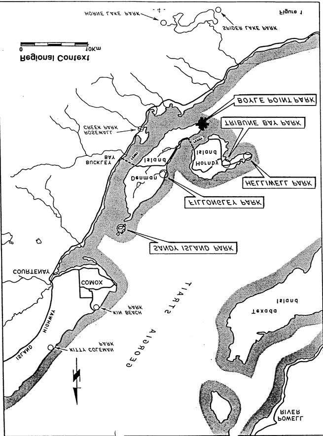
8 3.0 THE ROLE OF THE PARK 3.1 Regional/Provincial Context Denman Island is situated between Hornby Island and the sheltered central east coast of Vancouver Island, approximately halfway along Georgia Strait (Figure 1). The nearest urban areas on Vancouver Island are Courtenay- Comox (about 20 km north) and Nanaimo (about 80 km south). Denman Island is linked to Vancouver Island by a small ferry (10 to 15 minutes to cross). A similar ferry service connects Denman Island with Hornby Island. Although Denman Island is predominantly forested, much of the island is very pastoral in its setting with significant areas of agriculture and rural residential. The island s permanent population of about 1000 residents is supported by a small infrastructure of a few stores. Denman and Hornby Islands differ little from the more southerly Gulf Islands of Georgia Strait. Because of their scenic and rural nature, some people have chosen to settle and live year-round on these pleasant islands, while others have established summer cottages. There are five provincial parks on both islands that serve both island residents and visitors by conserving scenic natural areas and providing opportunities for outdoor recreation. 3
9
10 3.2 Conservation Role In keeping with the Provincial Park System conservation goal of protecting the province s outstanding scenic features, the conservation role of Boyle Point Provincial Park is to conserve and protect the scenic sandstone cliff environment of Denman Island. 3.3 Recreation Role The recreation goal of the Provincial Park System includes the provision of regional recreational opportunities to local and regional communities. Given this goal, it is the recreation role of Boyle Point Provincial Park to provide recreation opportunities, such as walking, viewing and nature appreciation to residents of and visitors to Denman Island. 5
11 4.0 ZONING Zoning is a procedure used to assist the planning and management of the provincial Park Act designations by dividing them into logical areas of land and water, based upon uniform and consistent management objectives. Boyle Point Provincial Park has been divided into three zones; Intensive Recreation Zone, Natural Environment Zone and Special Features Zone (Figure 2). Intensive Recreation Zone This zone is used to define areas of concentrated facility development and park use. Although the natural environment is dominant, the developed facilities are readily visible. Management is oriented to maintaining a high quality recreation experience with intensive management of resources and control of visitor activities. The proposed parking lot and surrounding area of the park entrance, about.5 hectare, are included in this zone. Most of the required facilities are concentrated here. Natural Environment Zone The Natural Environment Zone is used to define areas managed for dispersed recreation with moderate to low levels of use and only basic facilities, such as trails, are provided. The majority of the park reflects these conditions with about 107 hectares zoned as Natural Environment. If the proposed land addition of Lot 125 is implemented, it will be included in this zone. 6
12 Special Features Zone The Special Features Zone is used to define significant natural or cultural features or processes because of their special character, fragility and heritage value, and to protect and present these features to visitors. Facilities are restricted to providing access and interpretation development. The sandstone cliffs along the park shoreline are a significant feature of the Gulf Islands Regional Landscape and as the marsh area in the centre of the park is an important island ecosystem, it is included in the 17 hectares of the Special Features Zone. If Lot 127 is acquired as proposed, this zoning will also be applied to the sandstone feature of that lot which is used as a sea lion rookery during January and February. 7
13
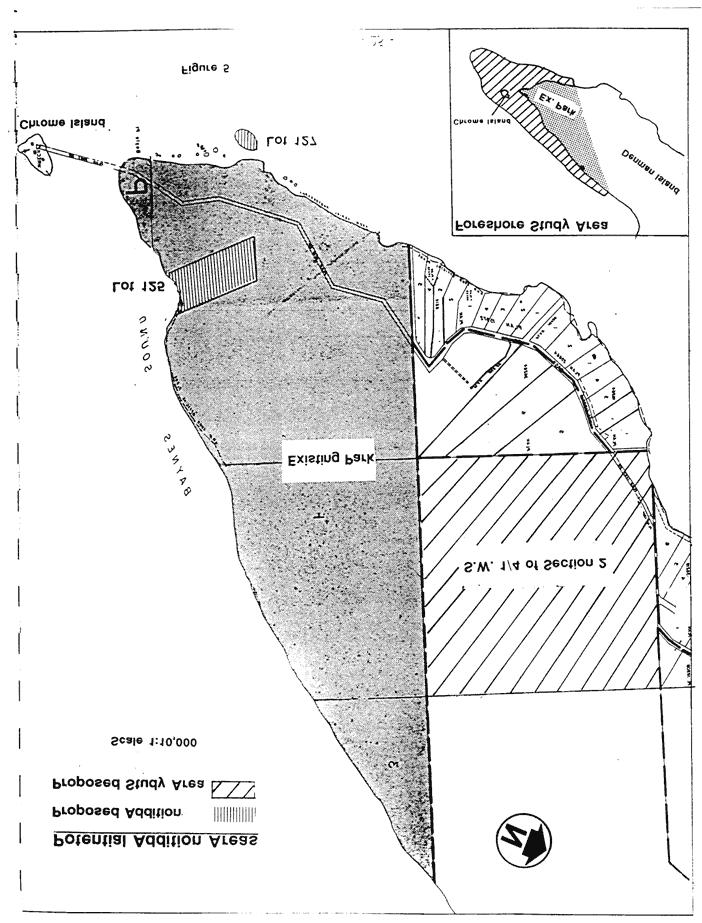
14 5.0 NATURAL AND CULTURAL RESOURCES MANAGEMENT The following management objectives and actions are based upon the Park Act, Park Regulations and appropriate ministry policies. 5.1 Land Management Objective: To expand the upland area and add a foreshore component to the park. Actions: Acquire Lots 125 and 127. Apply to BC Hydro to incorporate the hydro right-of-way within the park (Figure 5, page 25). Study the SW 1/4 of Section 2 as a potential addition. Establish a park study reserve over the foreshore fronting the park out to the 30 metre underwater contour. Prepare a marine park proposal. 5.2 Vegetation Management Objective: To manage the plant communities of the park to preserve their current natural state. Actions: Open fires will be prohibited. Wildfires caused by nature or man will be suppressed. Vegetation will be managed to prevent wildfires from occurring. Hazardous trees will be removed in accordance with ministry policy. Information will be provided as required to warn of fire hazards or the danger of falling trees during inclement weather. Harvesting flowers or other vegetation will be prohibited and will be discouraged through public education. 9
15 5.3 Wildlife Management Objective: To retain existing wildlife levels and diversity. Actions: Hunting or the discharge of firearms will be prohibited and the park will be added to Schedule B of Park Regulations. Dogs on leash regulations will be posted. Access to the sea lion rookery will be discouraged. Retain snags of cavity nesters and feeders unless a snag represents an imminent hazard to recreationists. 5.4 Soil Management Objective: To ensure minimum disturbance to soil and rock. Action: Pay strict attention to soil moisture regimes, soil classification and slope when modifying existing trails or designing new trails. 5.5 Water Management Objective: To protect and maintain in their present condition the water courses of the park. Action: Avoid developments near water courses, such as the marsh areas and ensure natural drainage is maintained. 5.6 Aesthetic Resources Objective: To protect the main visual resources of the park and enhance viewing opportunities where possible. Action: Provide viewpoints along the trail for visual access to Eagle Rock and Chrome Island. 10
16 6.0 VISITOR SERVICES MANAGEMENT 6.1 Introduction As Boyle Point Provincial Park primarily offers visitors the opportunity to enjoy nature in the forest and along the seashore, the general visitor services management concept is to keep facilities and services to a minimal level to promote the enjoyment of the natural character of the park. This concept reflects the anticipated general low use and the limited potential of park resources to provide a wide variety or quantity of recreational opportunities. Access will be provided through a parking area established at the fringe of the boundary with trails emanating from this central staging area. The information strategy of the park will focus on the presentation of park features and the encouragement of high standards for environmentally sensitive ways of enjoying the outdoors. 6.2 Visitor Opportunities Objective: To provide automobile and bicycle access day use, including walking, hiking, viewing, photography and nature appreciation. Actions: A day use parking area for 15 vehicles and bicycles will be developed at the park entrance (Figure 3). Automobile access camping will not be provided at Boyle Point Provincial Park, as sufficient supply is provided in the vicinity by the private sector and at Fillongley Provincial Park, a 5 minute drive away. 11
17
18 Bicycle access camping will not be provided at Boyle Point Provincial Park. However, the potential future addition of the SW 1/4 of Section 2 might accommodate development of walk-in and bicycle camping facilities. Boat access opportunities are extremely limited and overnight anchorage will not be encouraged. The park offers excellent opportunities for walking and day hiking. The trail system will include the BC Hydro access road and the existing trail which bisects the park and adjacent vacant Crown land (SW 1/4 of Section 2). A new trail will be developed along the western portion of the park, with loops back to existing trails. All trails will be Type 2 and designed to minimize impacts on forest vegetation. 6.3 Management Services Boyle Point Provincial Park is managed as part of the Strathcona District, the headquarters being at Rathtrevor Beach Provincial Park in Parksville. Wildfires will be controlled in cooperation with the Denman Island Volunteer Fire Department and the BC Forest Service. Garbage disposal services will not be provided at the park. Visitors will be requested to remove their own garbage. Potable water will not be provided at the park. 6.4 Promotion/Education Promotional information will be provided at the ferry terminals and in the park to raise the level of public awareness about the park s recreation opportunities and special natural features. In terms of education, the nature interpretation themes of the Douglas-fir forest, the cliffs, the sea lions and the marsh areas, as well as the significance of Chrome Island, will be presented through on-site signs. 13
19 7.0 IMPLEMENTATION In order of priority, the following actions are to be implemented as regional priorities dictate. 1. Develop visitor facilities at the entrance to the park, including a parking area for approximately 15 vehicles, pit toilets, a park information sign and gate. The view points at Eagle Rock and Chrome Island will also be built at this time. 2. Initiate discussion with BC Hydro concerning control of visitors and management of the right-of-way. 3. Implement the proposed park additions. 4. Initiate action to formulate a proposed marine park addition to the park including establishing a reserve over the foreshore area. 5. Pursue with the Ministry of Crown Lands in consultation with the Islands Trust the establishment of a map reserve over the SW 1/4 of Section 2, including the trail that passes through the site. 6. Expand the existing trail system. 14
20 BOYLE POINT PROVINCIAL PARK BACKGROUND REPORT APPENDIX I

21 1.0 INTRODUCTION Boyle Point Provincial Park consists of approximately 125 hectares of rolling forested land and precipitous rocky shoreline cliffs, comprising the southern tip of Denman Island in Georgia Strait. Historically, the area was held by the Crown Provincial for forestry purposes. The Director of Lands established a reserve from alienation for future recreational use on the parcel in In 1983, the Ecological Reserves Unit of the Ministry of Lands, Parks and Housing proposed that the area be designated an ecological reserve but a pre-existing petroleum exploration permit covering the area at the time precluded ecological reserve designation. In 1986, the Comox-Strathcona Regional District initiated creation of a Regional Nature Park for the area as part of its "Comox Valley Area Parks Plan". In 1989, the area was designated as a provincial park. 15

22 2.0 NATURAL RESOURCES 2.1 Land The park s terrain is relatively flat or undulating land bounded on three sides by steep sandstone and conglomerate escarpments dropping to the sea. The coastline is approximately 70% cliffs, the remainder sloping, with extremely limited land access to the foreshore. There are no protected bays or inlets. All beaches are boulder beaches. There is a small gravel beach which is accessible and relatively sheltered in front of Lot 125. Eagle Rock is a separate islet, accessible by land at low tide. The upland soil cover is generally shallow, overlaying rock rubble, gravel pockets, clay or flat-lying sandstone. There is a small marsh in the southwestern portion of the park. 16
23 2.2 Vegetation The park is dominated by a largely undisturbed plant community of the Douglas-fir biogeoclimatic subzone. Thirteen distinct plant communities occupy various areas of the park, although Douglas-fir, in community with grand fir, red alder, mosses, salal and various herbs and shrubs, dominate the upland. Old-growth Douglas-fir are found throughout the area amidst younger stands of + /- 100 years. There are several notable small stands of mature grand fir as well as scattered arbutus and broadleaf maple specimens. Specialized plant ecosystems are found along the sandstone escarpments. A fern, Dryopteris arguta, grows in the park and is rare in British Columbia, being at the northern fringe of its North American range. 2.3 Water The park area is largely very dry with no year-round running freshwater. The marsh in the southwesterly portion of the park holds seasonal surface water and drains to the gravel beach in Lot Climate The climate is moist, with most of the 70 to 100 cm of precipitation occurring between October and June. Summers are mild and dry, with temperatures moderated by a sea breeze from Georgia Strait. Average winter temperatures are slightly above freezing and snowfalls are rare. The dominant wind direction is from the southeast, with northwesterlies often prevailing in the summer months. 2.5 Wildlife Mammals: Although a wildlife inventory has not been conducted, the park represents one of the largest undisturbed parcels of land on the island, providing habitat for significant numbers of typical coastal species. The upland area is criss-crossed with deer trails, indicating a substantial population of Columbian black-tailed deer, while Steller s sea lions occupy the adjacent waters throughout the winter months and haul-out on Eagle Rock. At times the number of 17
24 sea lions have been estimated as high as 100 animals. This is one of only a handful of habitual sea lion haul-outs in the strait. Harbour seals are also often visible from the park and killer whales occasionally pass through Lambert Channel. River otters are seen along the foreshore areas. Birds: Residents report that there are outstanding bird-watching opportunities. Bald eagles are common and can often be seen at close range gliding on wind currents created above the cliffs. The large number of old-growth Douglas-fir trees favour eagle nesting and perching, and residents report a number of eagle nesting sites within the park. Other large forest birds, such as ravens, pileated woodpeckers and flickers are also reported, along with a variety of small songbirds. The adjacent cliffs, islets and waters support large bird populations which include cormorants, loons and gulls. Marine Life: The tidal waters of Boyle Point are rich in a variety of marine life. Although an underwater inventory has not been done, divers report a variety of marine life typical of these waters, including a few species of anemones, nudebrandra, scallops, octopus, Wolfe Eel, abalone and several species of rock fish. The water around Boyle Point is also an important Herring spawning area which may account for the influx of sea lions during the herring run in March. 18
25 2.6 Outdoor Recreation Features The main features of the park are the sandstone cliffs and forest. The sandstone and conglomerate rock cliffs are of high significance as a recreation feature because of their height, colour and visual interest, while the Douglas-fir forest of the park is highly significant because it is the largest protected unlogged area on Denman Island. 2.7 Resources Analysis The purpose is to briefly describe the significance of major park resources relative to the provincial park system conservation and recreation programs. a) Conservation Programs Natural Landscape Representation Boyle Point Provincial Park is located within the "Georgia Strait Lowland and Islands Landscape" but does not represent the range of landscape characteristics because of its size. Marine Environment Representation The park does not at present include an intertidal or underwater component. Outstanding Features - The upland forest represents an outstanding example of undisturbed dry coastal Douglas-fir regime. - The cliffs are quite spectacular and of interest for their geologic formations and specialized plant communities. 19
26 b) Recreation Programs Backcountry The park area is too limited for this use. Boating The shoreline is neither suitable nor accessible for boat launching. Road Access - The area is suited to day use, offering excellent opportunities for leisure walking, day hiking, nature study, viewing and photography. - The park is well situated for touring bicyclists, including groups en route to Hornby Island. Winter The climate is too mild for snow or ice oriented activities. Viewing of hauled-out sea lions is popular during the winter months. 20
27 3.0 TENURES, OCCUPANCY RIGHTS AND JURISDICTIONS Leases and Permits : Lots 125 and 127 are Crown leases. There is a foreshore lease fronting Lot 125 for mariculture Fee Simple Holdings : None Water Rights : None Rights-of-Way : BC Hydro Mineral Claims : None Trespasses : None Statutory Jurisdiction : None Guiding : None 21
28 4.0 VISITOR SERVICES 4.1 Existing Development (Figure 4) Parking At present, vehicles park at the beginning of the BC Hydro right-ofway, along the side of the road. Development of an off-road parking area to accommodate 15 vehicles is required. Toilet System None exists at present. Pit toilets should be provided at the parking area. Trails The BC Hydro service road, which is gated, serves as a trail to the southern tip of the park. A short, steep path down a bank connects this trail with the foreshore by Eagle Rock. A longer woodland footpath originates in the SW 1/4 of Section 2, roughly bisects that 1/4 section, then angles south and east to join the BC Hydro road near the park s southern tip. In Lot 125, a trail leads from this footpath down to the beach. Freshwater No potable water is available in the park area. 4.2 Management Services No services are provided at present. 4.3 Park Attendance and Visitor Activities As this is a newly-created park, there is no record of attendance or activities. The area has long been used by residents and visitors on a day use basis, primarily for hiking and nature study. Frequency of use by horseback riders, mountain bicyclists and trail bikers is not known, though at present, some of this use appears to be occurring. 22
29
30 5.0 PLANNING ISSUES 5.1 Park Additions (Figure 5) The SW 1/4 of Section 2 adjacent to the park is Crown land reserved for the Islands Trust with a small portion held as a gravel reserve in favour of the Ministry of Transportation and Highways. These lands contain the same forest values as is in the park and are part of the same drainage system. The trail through this parcel and into the park has been used by the public for many years. The Ministry of Crown Lands has been requested by the community to consider inclusion of this parcel in the park if and when the gravel reserve is cancelled. The Ministry of Crown Lands has undertaken to establish a Notation of Interest in this respect. The two parcels of land in the park contain complementary features that would be of interest to park visitors and would assist in park management; however, they are currently encumbered by Crown leases and in the case of Lot 125, a cabin trespass. The addition of the foreshore would provide protection over significant marine life and scuba diving recreational opportunities; however, an oyster lease encumbers the foreshore of Lot 125. The BC Hydro right-of-way and the access road is used as a trail to access the park. Control of public use and management of this area should be considered. 24
31
32 5.2 Level and Types of Development The main development requirement is an appropriate off-road parking area to establish an entrance and staging area for the park. Given the small size of the park, it is not considered appropriate to develop overnight camping facilities, though such development might be accommodated on a walk-in basis should the SW 1/4 of Section 2 be added to the park. Residents have repeatedly expressed concern that development be sensitive to the natural values of the area; for example, that trails be developed only as minimum-width footpaths and that no fencing be installed along the top of escarpments. The trail down the cliff to Eagle Rock is problematic, being potentially hazardous at present. Community opinion favours no improvement to the trail so as to discourage its use, thereby minimizing impacts upon both cliffside vegetation and hauled-out sea lions. 26
33 BIBLIOGRAPHY Holland, Stuart S., Landforms of British Columbia: A Physiographic Outline. Province of BC., Department of Mines and Petroleum Resources, Victoria. McKee, Bates, Cascadia: The Geologic Evolution of the Pacific Northwest. McGraw- Hill Book Company, New York. Province of British Columbia, Ministry of Forests, Forest Service Research Branch, Biogeoclimatic Units. Victoria-Vancouver (Map 1:500,000 N.T.S. Sheet 92 S.E.) Canadian Cartographics Ltd., Coquitlam, BC Province of British Columbia, Ministry of Lands, Parks and Housing, Parks and Outdoor Recreation Division, Natural Regions and Regional Landscapes for British Columbia s Provincial Park System. Parks and Outdoor Recreation Division, Victoria. Province of British Columbia, Ministry of Lands, Parks and Housing, Parks and Outdoor Recreation Division, Parks Data Handbook. Parks and Outdoor Recreation Division, Visitor Services, Victoria. Valentine, K.; Sprout, P.; Baker, T.; and Lavkulich, L.; The Soil Landscape of British Columbia. Ministry of Environment, Resource Analysis Branch, Victoria. 27
ROBERTS CREEK PROVINCIAL PARK MASTER PLAN. November, 1981
 Ministry of Lands, Parks and Housing Parks and Outdoor Recreation Division Park Operations Branch North Vancouver, B. C. ROBERTS CREEK PROVINCIAL PARK MASTER PLAN November, 1981 Mr. G. Trachuk Director
FILLONGLEY, TRIBUNE BAY, HELLIWELL, SANDY ISLAND PARKS MASTER PLAN
 FILLONGLEY, TRIBUNE BAY, HELLIWELL, SANDY ISLAND PARKS MASTER PLAN Province of Ministry of British Columbia Environment and Parks September 1987 Mr. H. V. Collins Assistant Deputy Minister Parks and Outdoor
Appendix A BC Provincial Parks System Goals
 Appendix A BC Provincial Parks System Goals The British Columbia Provincial Parks System has two mandates: To conserve significant and representative natural and cultural resources To provide a wide variety
MONTAGUE HARBOUR MARINE PROVINCIAL PARK
 MONTAGUE HARBOUR MARINE PROVINCIAL PARK PURPOSE STATEMENT AND ZONING PLAN March 2003 1 MONTAGUE HARBOUR MARINE PROVINCIAL PARK Purpose Statement and Zoning Plan Primary Role The primary role of Montague
ADDENDA. 1. It does not conform to the Master Plan format in the following areas: Statement of Purpose - clarification of parks purpose in system.
 File: 2-7-2-79-27 ADDENDA Plan for Saltery Bay Park This plan has been reviewed and is approved with the following comments and conditions: 1. It does not conform to the Master Plan format in the following
Marchand Provincial Park. Management Plan
 Marchand Provincial Park Management Plan 2 Marchand Provincial Park Table of Contents 1. Introduction... 3 2. Park History... 3 3. Park Attributes... 4 3.1 Natural... 4 3.2 Recreational... 4 3.3 Additional
VARGAS ISLAND PROVINCIAL PARK
 VARGAS ISLAND PROVINCIAL PARK PURPOSE STATEMENT AND ZONING PLAN February 2003 VARGAS ISLAND PROVINCIAL PARK Purpose Statement and Zoning Plan Primary Role The primary role of Vargas Island Park is to protect
2.0 PARK VISION AND ROLES
 2.0 PARK VISION AND ROLES 2.1 Significance in the Protected Area System Marble Range and Edge Hills provincial parks protect 6.8% of the Pavillion Ranges Ecosection, which is located in the Southern Interior
MARBLE RIVER PROVINCIAL PARK
 MARBLE RIVER PROVINCIAL PARK PURPOSE STATEMENT AND ZONING PLAN March 2003 MARBLE RIVER PROVINCIAL PARK Purpose Statement and Zoning Plan Primary Role The primary role of Marble River Park is to protect
5.0 OUTDOOR RECREATION OPPORTUNITIES AND MANAGEMENT
 5.0 OUTDOOR RECREATION OPPORTUNITIES AND MANAGEMENT 5.1 Introduction This section describes the range of recreational activities that currently take place in Marble Range and Edge Hills Parks, as well
SANTA-BOCA PROVINCIAL PARK
 SANTA-BOCA PROVINCIAL PARK PURPOSE STATEMENT AND ZONING PLAN March 2003 SANTA-BOCA PROVINCIAL PARK Purpose Statement and Zoning Plan Primary Role The primary role of Santa-Boca Park is to provide marine-based
ANAGEMENT. LAN November, 1996
 M ANAGEMENT P LAN November, 1996 for Paul Lake Provincial Park Ministry of Environment, Lands and Parks BC Parks Department Paul Lake Provincial Park M ANAGEMENT P LAN Prepared by BC Parks Kamloops Area
MAIN LAKE PROVINCIAL PARK
 MAIN LAKE PROVINCIAL PARK PURPOSE STATEMENT AND ZONING PLAN March 2003 MAIN LAKE PROVINCIAL PARK Purpose Statement and Zoning Plan Primary Role The primary role of Main Lake Park is to protect a biologically
Steps in the Management Planning Process
 Steps in the Management Planning Process Developing a management plan for Kalamalka Lake Park will follow a multi-stage process. The planning process for this park is currently in the Draft Management
BROUGHTON ARCHIPELAGO PROVINCIAL PARK
 BROUGHTON ARCHIPELAGO PROVINCIAL PARK PURPOSE STATEMENT AND ZONING PLAN March 2003 BROUGHTON ARCHIPELAGO PROVINCIAL PARK Purpose Statement and Zoning Plan Primary Role The primary role is to contribute
PLUMPER COVE MARINE PARK MASTER PLAN
 Lower Mainland Region Park Operations Branch Parks and Outdoor Recreation Division Ministry of Lands, Parks and Housing North Vancouver, B.C. PLUMPER COVE MARINE PARK MASTER PLAN DECEMBER, 1980 PLUMPER
Access: The rocky shoreline is only accessible via private property.
 10. Whale Cove Site description: Whale Cove is a small cove fringed by private homes and condominiums with diverse and relatively undisturbed rocky intertidal and subtidal habitat located approximately
Birch Point Provincial Park. Management Plan
 Birch Point Provincial Park Management Plan 2 Birch Point Provincial Park Table of Contents 1. Introduction... 3 2. Park History... 3 3. Park Attributes... 4 3.1 Natural... 4 3.2 Recreational... 4 4. Park
MANAGEMENT DIRECTION STATEMENT June, 1999
 Thompson River District MANAGEMENT DIRECTION STATEMENT June, 1999 for Roche Lake Provincial Park Ministry of Environment Lands and Parks BC Parks Division Table of Contents I. Introduction A. Setting
Wallace Lake Provincial Park. Management Plan
 Wallace Lake Provincial Park Management Plan 2 Wallace Lake Provincial Park Table of Contents 1. Introduction... 3 2. Park History... 3 3. Park Attributes... 4 3.1 Natural... 4 3.2 Recreational... 4 4.
Stuart River Provincial Park Purpose Statement and Zoning Plan
 Stuart River Provincial Park Purpose Statement and Zoning Plan Stuart River Provincial Park protects three-quarters of the 110 kilometer long Stuart River corridor between Stuart Lake and the Nechako River.
Mackinnon Esker Ecological Reserve Draft - Management Plan
 Mackinnon Esker Ecological Reserve Draft - Management Plan May 2011 Photo Credit: This document replaces the direction provided in the Carp Lake Provincial Park and Protected Area and Mackinnon Esker Ecological
Sasagiu Rapids Provincial Park. Draft Management Plan
 Sasagiu Rapids Provincial Park Draft Management Plan 2 Sasagiu Rapids Provincial Park Table of Contents 1. Introduction... 3 2. Background and Park Attributes... 3 2.1 Park History.... 3 2.2 Natural Features...
OCTOPUS ISLANDS PROVINCIAL PARK
 OCTOPUS ISLANDS PROVINCIAL PARK PURPOSE STATEMENT AND ZONING PLAN February 2003 OCTOPUS ISLANDS PROVINCIAL PARK Purpose Statement and Zoning Plan Primary Role The primary role of Octopus Islands Park is
MANAGEMENT DIRECTION STATEMENT
 Lower Mainland District MAAGEMET DIRECTIO STATEMET January 2001 for Liumchen Ecological Reserve Ministry of Environment Lands and Parks BC Parks Division Table of Contents Page Introduction... 1 Purpose
MANAGEMENT DIRECTION STATEMENT June, 1999
 Garibaldi/Sunshine Coast District MAAGEMET DIRECTIO STATEMET June, 1999 for Homathko Estuary Provincial Park Ministry of Environment Lands and Parks BC Parks Division TABLE OF COTETS Introduction...1
Watchorn Provincial Park. Management Plan
 Watchorn Provincial Park Management Plan 2 Watchorn Provincial Park Table of Contents 1. Introduction... 3 2. Park History... 3 3. Park Attributes... 3 3.1 Natural... 4 3.2 Recreational... 4 3.3 Additional
Proposed National Marine Conservation Area Reserve Southern Strait of Georgia PROJECT UPDATE Spring 2012
 Proposed National Marine Conservation Area Reserve Southern Strait of Georgia PROJECT UPDATE Spring 2012 National marine conservation areas (NMCAs) are established to protect, conserve and present examples
Whitemouth Falls Provincial Park. Draft Management Plan
 Whitemouth Falls Provincial Park Draft Management Plan Whitemouth Falls Provincial Park Draft Management Plan Table of Contents 1. Introduction... 3 2. Park History... 3 3. Park Attributes... 4 3.1 Natural...
Site description: 2.7 miles of intertidal habitat located about 2 miles north of Depoe Bay in Lincoln County, Oregon (Figure 16).
.") 8 Boiler Bay Site description: 27 miles of intertidal habitat located about 2 miles north of Depoe Bay in Lincoln County, Oregon (Figure 16) Designation: Boiler Bay was a research reserve before TSP publication,
8 Boiler Bay Site description: 27 miles of intertidal habitat located about 2 miles north of Depoe Bay in Lincoln County, Oregon (Figure 16) Designation: Boiler Bay was a research reserve before TSP publication,
MANAGEMENT DIRECTION STATEMENT June, 1999
 Thompson River District MANAGEMENT DIRECTION STATEMENT June, 1999 for Clearwater River Corridor (Addition to Wells Gray Park) Ministry of Environment Lands and Parks BC Parks Division ii Table of Contents
SPECTACLE LAKE PROVINCIAL PARK PURPOSE STATEMENT AND ZONING PLAN
 SPECTACLE LAKE PROVINCIAL PARK PURPOSE STATEMENT AND ZONING PLAN August 2003 1 SPECTACLE LAKE PROVINCIAL PARK Purpose Statement and Zoning Plan Primary Role The primary role of Spectacle Lake Park is to
Wallace Lake Provincial Park. Draft Management Plan
 Wallace Lake Provincial Park Draft Management Plan Wallace Lake Provincial Park Draft Management Plan Table of Contents 1. Introduction... 3 2. Park History... 3 3. Park Attributes... 4 3.1 Natural...
Continental Divide National Scenic Trail Legislative History and Planning Guidance
 Continental Divide National Scenic Trail Legislative History and Planning Guidance Legislation, Policy, and Direction Regarding National Scenic Trails The National Trails System Act, P.L. 90-543, was passed
A GUIDE TO MANITOBA PROTECTED AREAS & LANDS PROTECTION
 A GUIDE TO MANITOBA PROTECTED AREAS & LANDS PROTECTION Manitoba Wildands December 2008 Discussions about the establishment of protected lands need to be clear about the definition of protection. We will
KANANASKIS COUNTRY PROVINCIAL RECREATION AREAS MANAGEMENT PLAN DRAFT TERMS OF REFERENCE - November 20, 2007
 KANANASKIS COUNTRY PROVINCIAL RECREATION AREAS MANAGEMENT PLAN DRAFT TERMS OF REFERENCE - November 20, 2007 BACKGROUND There are 42 Provincial Recreation Areas (PRAs) within Kananaskis Country located
BLANKET CREEK PROVINCIAL PARK
 BLANKET CREEK PROVINCIAL PARK PURPOSE STATEMENT AND ZONING PLAN February 2003 BLANKET CREEK PROVINCIAL PARK Purpose Statement and Zoning Plan Primary Role The primary role of Blanket Creek Park is to maintain
EPPER PASSAGE PROVINCIAL PARK PURPOSE STATEMENT AND ZONING PLAN
 EPPER PASSAGE PROVINCIAL PARK PURPOSE STATEMENT AND ZONING PLAN August 2003 1 EPPER PASSAGE PROVINCIAL PARK Purpose Statement and Zoning Plan Primary Role The primary role of Epper Passage Park is to protect
D IRECTION S TATEMENT
 Vancouver Island Region M ANAGEMENT D IRECTION S TATEMENT September 2003 for Lower Nimpkish Provincial Park Ministry of Water, Land and Air Protection Environmental Stewardship Lower Nimpkish Provincial
BELLHOUSE PROVINCIAL PARK
 BELLHOUSE PROVINCIAL PARK PURPOSE STATEMENT AND ZONING PLAN March 2003 1 BELLHOUSE PROVINCIAL PARK Purpose Statement and Zoning Plan Primary Role The primary role of Bellhouse Provincial Park is to protect
ANAGEMENT. LAN November, 1996
 M ANAGEMENT P LAN November, 1996 for Coldwater River Provincial Park Ministry of Environment, Lands and Parks BC Parks Department Coldwater River Provincial Park M ANAGEMENT P LAN Prepared by BC Parks
Yard Creek Provincial Park. Management Plan
 Yard Creek Provincial Park Management Plan Draft January 2010 Yard Creek Provincial Park Management Plan Approved by: telàlsemkin/siyam/chief Scott Benton Bill Williams Squamish Executive Director ation
Ouimet Canyon Provincial Nature Reserve. Management Plan
 Ouimet Canyon Provincial Nature Reserve Management Plan NOTE: This document has been scanned and formatted, and therefore is slightly different from the original version. -March 2002 Additional copies
Visual and Sensory Aspect
 Updated All Wales LANDMAP Statistics 2017 Visual and Sensory Aspect Final Report for Natural Resources Wales February 2018 Tel: 029 2043 7841 Email: sw@whiteconsultants.co.uk Web: www.whiteconsultants.co.uk
1 INFORMATION REQUIREMENTS
 1 INFORMATION REQUIREMENTS 1.1 BACKGROUND 2 1.2 WHAT IS THE DISTRICT PLAN 3 1.3 DISTRICT PLAN STRUCTURE 4 1.4 HOW TO USE THE DISTRICT PLAN 5 1.5 STRATEGIC FRAMEWORK 6 Whanganui District Plan (15 January
Nakina Moraine Provincial Park. Interim Management Statement. Ontario. Ministry of Natural Resources
 Nakina Moraine Provincial Park Interim Management Statement Ontario Ministry of Natural Resources 1999, Queen's Printer for Ontario Printed in Ontario, Canada Additional copies of this publication can
APPENDIX. Alberta Land Stewardship Act AMENDMENTS TO THE SOUTH SASKATCHEWAN REGIONAL PLAN
 APPENDIX Alberta Land Stewardship Act AMENDMENTS TO THE SOUTH SASKATCHEWAN REGIONAL PLAN 1 All references to Alberta Environment and Sustainable Resource Development, Environment and Sustainable Resource
Clearwater Lake Provincial Park. Draft Management Plan
 Clearwater Lake Provincial Park Draft Management Plan Clearwater Lake Provincial Park Draft Management Plan Table of Contents 1. Introduction... 3 2. Park History... 4 3. Park Attributes... 4 3.1 Location/Access...4
Draft Concept Plan. for the. Proposed Saskatoon Mountain Provincial Recreation Area
 Draft Concept Plan for the Proposed Saskatoon Mountain Provincial Recreation Area April 2014 Table of Contents INTRODUCTION... PROPOSAL SUMMARY... 1.0 DESCRIPTION OF THE PROPOSED SASKATOON MOUNTAIN PROVINCIAL
Dragon Mountain Park. Management Plan. Public Review Draft
 Disclaimer: This draft management plan contains preliminary proposals that are subject to change and therefore may not necessarily reflect the position of the Ministry of Environment. At the conclusion
TABLE OF CONTENTS. B. STATEMENT OF PURPOSE 8 1. Park Objectives 8 2. Manageme nt Philosophy 8
 TABLE OF CONTENTS Page A. INTRODUCTION 1 1. Setting 1 2. Regional Perspective 1 3. Present Development and Use 3 4. Land Status and Access 4 5. Demand 6 6. Purpose of Master Plan 7 B. STATEMENT OF PURPOSE
ANAGEMENT P LAN. July for Chilliwack Lake Park & Chilliwack River Ecological Reserve. Ministry of Environment, Lands and Parks BC Parks Division
 M ANAGEMENT P LAN July 2000 for Chilliwack Lake Park & Chilliwack River Ecological Reserve Ministry of Environment, Lands and Parks BC Parks Division Chilliwack Lake Provincial Park & Chilliwack River
NICOLUM RIVER PARK MASTER PLAN. July, 1983
 Ministry of Lands, Parks and Housing Parks and Outdoor Recreation Division Lower Mainland Region NICOLUM RIVER PARK MASTER PLAN July, 1983 TABLE OF CONTENTS PART 1: SUMMARY AND BACKGROUND A. Plan Summary...1
Dragon Mountain Park. Management Plan
 Dragon Mountain Park Management Plan December 2015 Dragon Mountain Park Management Plan Approved by: Peter Weilandt A/Regional Director Thompson Cariboo Region BC Parks December 14. 2015 Date Brian Bawtinheimer
MANAGEMENT DIRECTION STATEMENT March 2003
 Skeena Region MAAGEMET DIRECTIO STATEMET March 2003 for Meziadin Lake Provincial Park Ministry of Water, Land and Air Protection Environmental Stewardsh Division This page left blank on purpose ii Table
The following criteria were used to identify Benchmark Areas:
 7.0 BENCHMARK AREAS The Churn Creek Protected Area offers a significant opportunity to learn more about how grassland ecosystems function. One of the key tools that will be used to monitor larger grassland
STONE MOUNTAIN PROVINCIAL PARK Purpose Statement and Zoning Plan
 1 STONE MOUNTAIN PROVINCIAL PARK Purpose Statement and Zoning Plan Stone Mountain Provincial Park is situated 140 km west of Fort Nelson at Kilometre 595 of the Alaska Highway. The 25 690 ha park is located
Canadian Cataloguing in Publication Data Main entry under title: Master plan for Botanical Beach Provincial Park.
 Canadian Cataloguing in Publication Data Main entry under title: Master plan for Botanical Beach Provincial Park. Cover title. Includes bibliographical references. ISBN 0-7726-1622-1 1. Botanical Beach
Connie Rudd Superintendent, Black Canyon of the Gunnison National Park
 National Park Service U.S. Department of the Interior Black Canyon of the Gunnison National Park and Curecanti National Recreation Area Information Brochure #1 Wilderness and Backcountry Management Plan
Victor Lake Park. Management Plan
 Victor Lake Park Management Plan November 2012 Victor Lake Park Management Plan Approved by: Jeff Leahy, Regional Director Thompson Cariboo Region BC Parks March 28, 2012 Date Brian Bawtinheimer, Executive
South Atikaki Provincial Park. Draft Management Plan
 South Atikaki Provincial Park Draft Management Plan South Atikaki Provincial Park Draft Management Plan Table of Contents 1. Introduction... 3 2. Park History... 3 3. Park Attributes... 3 3.1 Natural...
ONE ISLAND LAKE PROVINCIAL PARK Purpose Statement and Zoning Plan
 ONE ISLAND LAKE PROVINCIAL PARK Purpose Statement and Zoning Plan Primary Role The primary role of One Island Lake Provincial Park is to provide recreational opportunities to regional and residential area
Bayview Escarpment. Interim Management Statement
 Bayview Escarpment Interim Management Statement Bayview Escarpment Provincial Nature Reserve Interim Management Statement January 15, 1995 REGIONAL DIRECTOR'S APPROVAL STATEMENT This Interim Management
Mackinnon Esker Ecological Reserve. Management Plan
 Mackinnon Esker Ecological Reserve Management Plan March 2017 Cover Page Photo Credit: Rob Bell This document replaces the direction provided in the Carp Lake Provincial Park and Protected Area and Mackinnon
10.7 Acre Oceanfront North Rendezvous Island
 10.7 Acre Oceanfront North Rendezvous Island Jamie Zroback jamie@landquest.com 1 (604) 483-1605 Jason Zroback jason@landquest.com 1 (604) 414-5577 The Source for Oceanfront, Lakefront, Islands, Ranches,
Alternative 3 Prohibit Road Construction, Reconstruction, and Timber Harvest Except for Stewardship Purposes B Within Inventoried Roadless Areas
 Roadless Area Conservation FEIS Summary Table S-1. Comparison of Key Characteristics and Effects by Prohibition Alternative. The effects summarized in this table A would occur in inventoried roadless areas
Town of Oakfield Agricultural and Farmland Protection Plan
 SECTION III COMMUNITY OVERVIEW A. Regional Setting / Location The Town of Oakfield is located in the northwestern portion of Genesee County. Located west of New York's Finger Lakes, the Town is uniquely
Flow Stand Up Paddle Board Parkway Plan Analysis
 Regional Parks Department Jeffrey R. Leatherman, Director County of Sacramento Divisions Administration Golf Leisure Services Maintenance Rangers Therapeutic Recreation Services Flow Stand Up Paddle Board
Pillar Park. Management Plan
 Pillar Park Management Plan January 2014 Pillar Park Management Plan Approved by: Jeff Leahy Regional Director Thompson Cariboo Region BC Parks January 9, 2014 Date Brian Bawtinheimer Executive Director
Natural and Cultural Values and Their Management...18
 Skagit Valley Provincial Park Management Plan Table of Contents Plan Highlights...4 Introduction...5 The Management Planning Process...5 Background Summary...6 Relationship to Other Land Use Planning...8
Rocky Lake Provincial Park. Draft Management Plan
 Rocky Lake Provincial Park Draft Management Plan Rocky Lake Provincial Park Draft Management Plan Table of Contents 1. Introduction... 3 2. Park History... 3 3. Park Attributes... 4 3.1 Location/Access...4
Hudson Bay Lowlands Proposed Protected Areas
 Hudson Bay Lowlands Proposed Protected Areas Hudson Bay Lowlands Proposed Protected Areas The Protected Areas Initiative has identified portions of the Hudson Bay Lowlands region that have significant
Seager Wheeler Lake. Representative Area. -- Concept Management Plan --
 Seager Wheeler Lake Representative Area -- Concept Management Plan -- Saskatchewan Environment and Resource Management January, 1999 Saskatchewan s Representative Areas Network Program The Government of
Procedure for the Use of Power-Driven Mobility Devices on Mass Audubon Sanctuaries 1 September 17, 2012
 Procedure for the Use of Power-Driven Mobility Devices on Mass Audubon Sanctuaries 1 September 17, 2012 Background As part of Mass Audubon s mission to preserve the nature of Massachusetts for people and
Ontario s Approach to Wilderness: A Policy May 1997 (Version 1.0)
") Ontario s Approach to Wilderness: A Policy May 1997 (Version 1.0) 1.0. Introduction Wilderness is important to Ontarians, important to the sustained, healthy functioning of Ontario s ecosystems. The Ministry
Ontario s Approach to Wilderness: A Policy May 1997 (Version 1.0) 1.0. Introduction Wilderness is important to Ontarians, important to the sustained, healthy functioning of Ontario s ecosystems. The Ministry
Dividing Lake Provincial Nature Reserve
 - Do Not Remove i, '" i ' Dividing Lake Provincial Nature Reserve I!.' Interim Management Statement Amendment 2001-001 Park Boundary Amendment Approved: r.in'r entral Zone, Ontario Parks PJ Date 2. ()/
Pembina Valley Provincial Park. Draft Management Plan
 Pembina Valley Provincial Park Draft Management Plan 2 Pembina Valley Provincial Park Table of Contents 1. Introduction... 3 2. Park History... 3 3. Park Attributes... 3 3.1 Natural... 3 3.2 Recreational...
FINGER-TATUK PROVINCIAL PARK
 FINGER-TATUK PROVINCIAL PARK PURPOSE STATEMENT AND ZONING PLAN March 2003 FINGER-TATUK PROVINCIAL PARK Purpose Statement and Zoning Plan Finger-Tatuk Provincial Park is 17,151 ha in size. It includes the
2.0 Physical Characteristics
 _ 2.0 Physical Characteristics 2.1 Existing Land Use for the Project The site is comprised of approximately 114 acres bounded by Highway 101 to the north, the existing town of Los Alamos to the east, State
Little Limestone Lake Provincial Park. Draft Management Plan
 Little Limestone Lake Provincial Park Draft Management Plan Little Limestone Lake Provincial Park Draft Management Plan Table of Contents 1. Introduction... 3 2. Background... 3 3. Planning context...
communication tower means a tower or structure built to support equipment used to transmit communication signals;
 Ontario Ministry of Natural Resources Subject Communication Tower Sites on Crown Land Compiled by - Branch Lands & Waters Section Land Management Policy PL 4.10.02 Replaces Directive Title Communication
MANAGEMENT DIRECTION STATEMENT March 2003
 Skeena Region MAAGEMET DIRECTIO STATEMET March 2003 for Lowe Inlet Marine Provincial Park Ministry of Water, Land and Air Protection Environmental Stewardshi Division This page left blank on purpose
A CONCEPT FOR F.H. BARBER PROVINCIAL PARK.
 A CONCEPT FOR F.H. BARBER PROVINCIAL PARK. 2-7-4-101-27 APPROVAL This Concept for F.H. Barber Provincial Park has been reviewed and is approved. Lower Mainland Region Parks and Outdoor Recreation Division
Lion s Head. Interim Management Statement
 Lion s Head Interim Management Statement Lion's Head Provincial Nature Reserve Interim Management Statement July 14, 1997 APPROVAL STATEMENT This Interim Management Statement will provide interim direction
MASTER PLAN EXECUTIVE SUMMARY
 Biscuit Run State Park Scottsville Road (State Route 20) Charlottesville, VA 22902 Biscuit Run State Park MASTER PLAN EXECUTIVE SUMMARY Department of Conservation and Recreation Division of Planning and
APODACA PROVINCIAL PARK MASTER PLAN. November, 1983
 South Coast Region Parks and Outdoor Recreation Division Ministry of Lands, Parks and Housing APODACA PROVINCIAL PARK MASTER PLAN November, 1983 TABLE OF CONTENTS PAGE PART I: SUMMARY AND BACKGROUND A.
Pinawa Provincial Park. Draft Management Plan
 Pinawa Provincial Park Draft Management Plan Pinawa Provincial Park Draft Management Plan Table of Contents 1. Introduction... 3 2. Park History... 3 3. Park Attributes... 4 3.1 Natural... 4 3.2 Recreational...
FILE: /PERM EFFECTIVE DATE: May 16, 2014 AMENDMENT:
 APPROVED AMENDMENTS: Effective Date Briefing Note /Approval Summary of Changes: FILE: 11000-00/PERM EFFECTIVE DATE: May 16, 2014 AMENDMENT: Table of Contents 1. POLICY APPLICATION... 1 2. PRINCIPLES AND
Pinellas County Environmental Lands
 Pinellas County Environmental Lands In addition to traditional parks and recreation facilities, Pinellas County owns and manages a system of environmental lands that provides specialized resource-based
Two Lots with Drilled Well Savary Island, BC
 Two Lots with Drilled Well Savary Island, BC Jason Zroback jason@landquest.com 1 (604) 414-5577 Jamie Zroback jamie@landquest.com 1 (604) 483-1605 Marketing British Columbia to the World The Source for
PROPOSAL FOR RECLASSIFICATION, BOUNDARY AMENDMENT AND DRAFT CONCEPT PLAN FOR SASKATOON MOUNTAIN NATURAL AREA. Frequently Asked Questions
 PROPOSAL FOR RECLASSIFICATION, BOUNDARY AMENDMENT AND DRAFT CONCEPT PLAN FOR SASKATOON MOUNTAIN NATURAL AREA 1. Why is this proposal being put forward? Frequently Asked Questions For many years, Alberta
INFORMATION NOTICE 15-2 Limited & Excluded Lands
 INFORMATION NOTICE 15-2 Limited & Excluded Lands Schedule 1 (Land Description) of onshore petroleum Agreements issued by the Department of Energy details the total hectares calculated. Total hectares are
VOLUME II APPENDIX F DETAILED PHYSICAL DESCRIPTION OF PROJECT RESERVOIRS AND LANDS
 VOLUME II APPENDIX F DETAILED PHYSICAL DESCRIPTION OF PROJECT RESERVOIRS AND LANDS THE CENTRAL NEBRASKA PUBLIC POWER AND IRRIGATION DISTRICT FERC PROJECT NO. 1417 PHYSICAL DESCRIPTION OF PROJECT LANDS
Kwadacha Wilderness Provincial Park and Kwadacha Addition (Kwadacha Recreation Area) Purpose Statement and Zoning Plan
 Purpose Statement and Zoning Plan") Kwadacha Wilderness Provincial Park and Kwadacha Addition (Kwadacha Recreation Area) Purpose Statement and Zoning Plan Located in a remote area of the northern interior of BC, this large park straddles
Kwadacha Wilderness Provincial Park and Kwadacha Addition (Kwadacha Recreation Area) Purpose Statement and Zoning Plan Located in a remote area of the northern interior of BC, this large park straddles
Davis Lake Provincial Park ANAGEMENT P LAN. (Draft Report Under Review) Prepared by Regional Operations Lower Mainland North Vancouver, BC
 Prepared by Regional Operations Lower Mainland North Vancouver, BC") Davis Lake Provincial Park M ANAGEMENT P LAN (Draft Report Under Review) Prepared by Regional Operations Lower Mainland North Vancouver, BC M ANAGEMENT P LAN April 2002 for Davis Lake Provincial Park Ministry
Davis Lake Provincial Park M ANAGEMENT P LAN (Draft Report Under Review) Prepared by Regional Operations Lower Mainland North Vancouver, BC M ANAGEMENT P LAN April 2002 for Davis Lake Provincial Park Ministry
Beaver Creek Provincial Park. Management Plan
 Beaver Creek Provincial Park Management Plan 2 Beaver Creek Provincial Park Table of Contents 1. Introduction... 3 2. Park History... 3 3. Park Attributes... 4 3.1 Natural... 4 3.2 Recreational... 4 4.
3.0 EXISTING PARK & RECREATION SPACE
 3.0 EXISTING PARK & RECREATION SPACE TOWN PARK & RECREATION SPACE An inventory of current parks and recreation area in the Town of Cedarburg is shown in Table 3. These areas total roughly 381.89 acres.
Sand Lakes Provincial Park. Draft Management Plan
 Sand Lakes Provincial Park Draft Management Plan 2 Sand Lakes Provincial Park Table of Contents 1. Introduction... 3 2. Background... 3 3. Park Purpose... 5 4. Park Management Guidelines... 6 Appendix...
Ontario. Tide Lake Provincial Nature Reserve. Interim Management Statement. Ministry of Natural Resources
 Ontario Tide Lake Provincial Nature Reserve nterim Management Statement Ministry of Natural Resources Tide Lake Provincial Nature Reserve nterim Management Statement Ontario Ministry of Natural Resources
Two Lots with Fixer-Upper Cabin & Drilled Well
 Two Lots with Fixer-Upper Cabin & Drilled Well Jason Zroback jason@landquest.com 1 (604) 414-5577 Jamie Zroback jamie@landquest.com 1 (604) 483-1605 Marketing British Columbia to the World The Source for