TABLE OF CONTENTS. B. STATEMENT OF PURPOSE 8 1. Park Objectives 8 2. Manageme nt Philosophy 8
|
|
|
- Solomon Bishop
- 5 years ago
- Views:
Transcription
1
2
3
4 TABLE OF CONTENTS Page A. INTRODUCTION 1 1. Setting 1 2. Regional Perspective 1 3. Present Development and Use 3 4. Land Status and Access 4 5. Demand 6 6. Purpose of Master Plan 7 B. STATEMENT OF PURPOSE 8 1. Park Objectives 8 2. Manageme nt Philosophy 8 C. PARK RESOURCES STATEMENT 9 1. Natural History 9 2. Cultural History 11 D. Z 0 N I N G 12 E. PARK MANAGEMENT Resource Management Visitor Management Administration 17
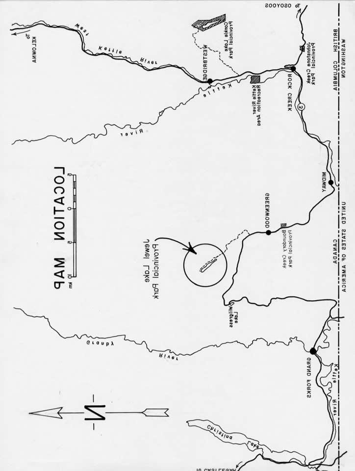
5 1 A. INTRODUCTION 1. Setting Jewel Lake is located 10 kilometres north of Greenwood in the Kettle River-Boundary Creek area of the West Kootenays. It is the largest and one of only two lakes close to Highway 3 between Osoyoos and Christina Lake. Bounded by forested mountains and at an elevation of 1,066 metres, the lake and its environs have the natural attributes to create an attractive park oriented to both easy access destination and local day use. The large recreational reserve at the north end of the lake has been used for years primarily by campers and fishermen. The southwest shore and south end of the lake are privately developed for cottaging and recreational use. Jewel Lake Resorts Ltd. at the south end offers camping and day use facilities along with boat and cottage rentals. A public boat launch is also situated at the south end of the lake. 2. Regional Perspective Jewel Lake is an important feature of the Greenwood-Midway area, as it represents the only suitable local lake for provision of opportunities for public swimming and beac h oriented activities. It also offers excellent potential for an easy access destination oriented park relating to a forested lake environment. Conkle Lake, located northwest of Rock Creek, provides a similar experience but access is comparatively more difficult. Wilgress Lake is the only other small lake along the same section of Highway 3, however, the potential for intensive use at this lake is relatively limited. As the major lake in this western portion of the Kootenay Region, Christina Lake is highly developed and intensively used for swimming, power boating and water skiing.
6 2
7 3 3. Present Development and Use The recreational reserve at the north end of Jewel Lake has some old Forest Service toilets, tables and rock fire circles. Present use tends to be heavy on weekends during the peak fishing periods of May to June and the early fall months. Litter, impacted soil and damaged vegetation are evidence of the heavy use which is presumed to be primarily originating from local and regional populations, and to a lesser extent from other regions of the province, particularly the Okanagan. Recreational activities are informal and include camping, fishing, boating, hiking and nature studies. The prominent sand mounds and beach at the southeast corner of the lake have in the past served as a popular local swimming and day use area. The site has been closed off to the public and is now the subject of delayed land exchange negotiations between the owner and the Crown. There are no other suitable swimming beaches on the lake.
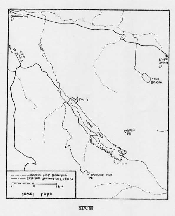
8 4 4. Land Status and Access The recreational reserve takes in the north end of the lake and most of the northern half of the west shore. The initial reserve, established in 1949, was later amended in 1971 to contain 49 hectares. Proposed Park boundaries will take in the existing reserve. The primary resource agencies have given approval to the Park proposal. Formal letters of approval have been received from the Forest Service, the Ministry of Mines and the Ministry of Highways. Forest and mining interests, however, require conditional guarantees for access through the Park for resource hauling purposes. It is felt that such access could be accommodated through Park Use Permit with restrictions imposed for off-season hauling and/or limitations on hours of hauling. Complications with private land, mineral claims and forest development plans obviate any options to expand Park boundary proposals outside of the existing reserve. Instead, inter-agency co-ordination through the Regional Resource Management Committee will be depended upon for protection of visual and recreational qualities around the lake.
9 5
10 6 Colt Resources Ltd. holds an option on mineral claim rights over a portion of Subdivision A, Lot 860. This property is being negotiated for on a land exchange basis to permit development of beach and picnic facilities at the southeast end of the lake. Acquisition of this property has been stalled indefinitely because titles cannot be registered until legal access is provided to the owner's (Mrs. W. Mather) other property north of adjacent Subdivision B. Colt Resources Ltd. is not prepared to agree to a quit claim over its claim on Subdivision A to permit the legal right-of-way. Access to the south end of the recreational reserve is along a good paved, two-way road. From this point access conditions deteriorate to a rough single lane. The road through the reserve will require proper surveying and a plan for gazetting. 5. Demand From indications of wear and tear within the recreational reserve, it is evident that Park facilities and maintenance are long overdue at Jewel Lake. Use figures are not available and there is no comparable Park within this part of the Region from which to base an estimate of demand. However, owners of the Jewe l Lake Fishing Lodge cannot satisfy present camping and day use demands at their site and are strongly supportive of Provincial Park development on the lake to alleviate some of the use pressures. There is obvious need for picnicking and swimming facilities in the Greenwood- Midway area based on the fact that opportunities for these activities are limited within reasonable day use distance of local residents. Jewel Lake offers the only suitable location to provide day use opportunities for the local population base.
11 7 6. Purpose of Master Plan This Master Plan is intended to provide basic information and statement of objectives to guide development and management of a Park at Jewel Lake. Future reviews of the Plan will likely call for revisions to reflect park evolution and changing requirements brought about by greater public awareness and use of the lake.
12 8 B. STATEMENT OF PURPOSE 1. Park Objectives The initial goal is to provide the facility base and services for maintenance of a Park at current use levels. In the longer term, the Parks Division will fulfill two primary regional objectives at Jewel Lake: 1.) Provision of lakeside day use facilities to serve recreation needs of local residents. 2.) Provision of facilities and services to promote high quality public enjoyment of natural recreational features and attractions of Jewel Lake and environs, with emphasis on destination/vacation oriented use. Recreational activities will include quality fishing, camping, picnicking, swimming, boating, hiking and nature study. 2. Management Philosophy Emphasis for Park development and management must be directed toward maintaining a "natural environment experience". In the initial stage there will be minimal interruption to the informal nature of present use patterns. Visitor use controls will only be imposed where necessary to reduce environmental impacts.
13 9 C. PARK RESOURCES STATEMENT The nature of the lake and its environs lends itself well to development of a quality Provincial Park. 1. Natural History a.) Climate and Vegetation Jewel Lake is situated in the interior dry belt zone. Temperatures rise rapidly in the spring and the weather stays generally warm and dry, with the exception of June which has records of a comparatively rainy regime. Through the summer, the days are hot and dry and the nights are cool. Snow sets in towards the end of November and is usually melted away by mid-april. The vegetation is classified as semi-dry Douglas fir-western larch type, characterized as mixed coniferous stands of Douglas fir, larch, lodgepole pine, Ponderosa pine, white pine, spruce, alpine fir, red cedar and hemlock with some deciduous components, primarily of birch and aspen. Large cottonwoods and heavy willow margins occur along the lakeshore and around the two marshes at the north end of the lake. The south side of Mt. Roderick Dhu leads up from relatively dense valley bottom forests to open Ponderosa pine-douglas fir and extensive grass slopes. By contrast, the slopes of Mt. Pelly on the south side of the lake are north facing and heavily timbered.
14 10 b.) Physiography Jewel Lake is within the Southern Monashee Mountains Unit of the Columbia Mountains Physiographic Region (Youds, 1979). The setting typifies this Unit, and will meet some of the criteria for fulfilling the Natural History Objectives within the Region. The lake is approximately 3 kilometres long and averages 1/3 kilometre across. Water levels are maintained by groundwater seepage. Jewel Creek outlet at the south end of the lake forms the outflo w. The lake warms to comfortable swimming temperatures by early July. The water is clear and of relatively good quality. The mountain ridges run parallel on either side of the lake in a north-easterly direction. The steep slopes of Mt. Pelly on the south side rise uniformly from the water's edge at 1127 metres to an elevation of 1550 metres. A series of slopes and intervening benches rise in steps to the top of Mt. Roderick Dhu, which is the dominant peak of the area at an elevation of 1830 metres. A short 30 metre rise at the north end of the lake forms a low pass into the drainage of the Granby River. The terrain at this end of the lake is relatively level. The shoreline within the existing reserve is generally contoured by steep banks. The offshore tends to drop quickly to deep water. c.) Fish and Wildlife The diversified habitats of the proposed Park are well represented by the common and typical mammals and birds of the Kettle River highlands. The mountains around Jewel Lake are important summer and fall range for mule deer. The south slopes are also used by mule deer during moderate winters.
15 11 The lake is reputed to have produced world record rainbows, however, except for pictures, there is no substantive proof to validate the truth of the stories. The present fishery is productive with rainbows averaging 1/2 to 1 kilogram. The creek outlet provides sufficient spawning habitat to maintain the excellent fishing opportunities. 2. Cultural History Collapsed buildings, rail lines, mine shafts and sand tailings located on Subdivision A and the slopes above date back to mining work carried out prior to 1936 by Jewel Lake Gold Mines. These may have value for interpretation, however, in their present state there is some danger posed to the public. There are no known archaeological sites in the Park.
16 12 D. ZONING The whole of the Park will be zoned "Development" to reflect the emphasis on recreational use.
17 13 E. PARK MANAGEMENT 1. Resource Management a.) Watersheds The Park is partially situated in the Grand Forks watershed. Development will require approval from watershed controllers. The Health Branch has recommended that mine tailings on Subdivision A be removed and placed in a safe landfill site and that the beach be developed using clean sand. Cya nide, sulphide minerals and other chemical reagents would likely contaminate the lake if the sand piles were levelled out. The Parks Division will ensure that development of Subdivision A follows the Health Branch recommendations. b.) Land and Forests Forest stands in the Park will be assessed for hazard potential prior to development. Measures may have to be taken prior to or during construction to reduce the hazard to acceptable levels. There is some concern that milfoil could infest the lake. The Park will display information signs co-ordinated through the present province-wide program to prevent the spread of milfoil. A fire contingency plan will be formulated. c.) Wildlife and Fish The Parks Division will ensure that development and use of the Park does not disturb fisheries values in the lake. The lake edge fringe, which is the critical feeding and rearing habitat for trout, must be protected. Wildlife and fishery enhancement projects will be accommodated if compatible with recreational and resource management objectives for the Park.
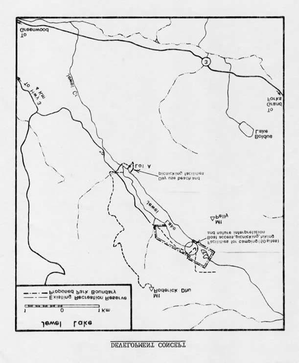
18 14 2. Visitor Management a.) Recreation The initial primary concern at Jewel Lake is the provision of a much improved maintenance function with facilities and services relating to the nature and scale of present use levels. By controlling inappropriate vehicle use and designating campsites at the northeast end of the lake, it should be possible to curb unnecessary damage without interfering with public enjoyment of the site. Proper toilets, garbage facilities, tables, fireplaces and fire wood will assure basic amenities and further reduce recreational use impacts. In keeping with the proposed 8 kph restriction on the lake, the Parks Division will not develop a ramp on the lake and will only encourage the use of small car-top boats. It would appear that park development on Sublot A has been effectively stymied for some indefinite period. There will continue to be no satisfactory public swimming area on the lake until this problem is resolved. In the long term, the Park will be developed as a destination oriented facility offering opportunities for fishing, swimming, camping, hiking, boating and nature study. b.) require: Implementation of Development Programs Initial development will be concentrated at the north end of the lake and will (1) Retaining and designating the well used, durable sites as campsites. (2) Designating parking spaces. (3) Providing 25 Type II tables.
19 15
20 16 allotted. (4) Establishing pit toilets and wood-garbage corrals. (5) Formalizing boat drop-off site. (6) Providing well and hand pump. (7) Improving road access to accommodate two way traffic. The initial capital development program will be carried out in 1981, with $40,000 Future development will establish an auto access campground on the northeast end of the lake. Facilities will be designed to provide for recreation in context and close association with the natural environment. The campground should have the appearance of being naturally immersed within the environs, with individual sites spaced to give the visitor some sense of privacy. Type II tables would be very much in keeping with the nature of the Park. The campground will consist of 50 sites. A day use beach with picnic facilities will be given funding priority as soon as Subdivision A is transferred to Parks jurisdiction. c.) Information and Interpretation Information will be provided on a B-4-1 shelter to orient the visitor to the Park and its facilities, services and regulations, and to other activities and attractions available in the local area. The Park offers excellent natural history interpretive potential and should be considered in the future for development of a nature trail/self-guiding type of program. Consideration should also be given to interpretation of the old mine at the southeast end of the lake. 3. Administration This Park will be administered by the West Kootenay Park District through the Sub- District Headquarters at Kettle River Recreation Area.
ANAGEMENT. LAN November, 1996
 M ANAGEMENT P LAN November, 1996 for Paul Lake Provincial Park Ministry of Environment, Lands and Parks BC Parks Department Paul Lake Provincial Park M ANAGEMENT P LAN Prepared by BC Parks Kamloops Area
ROBERTS CREEK PROVINCIAL PARK MASTER PLAN. November, 1981
 Ministry of Lands, Parks and Housing Parks and Outdoor Recreation Division Park Operations Branch North Vancouver, B. C. ROBERTS CREEK PROVINCIAL PARK MASTER PLAN November, 1981 Mr. G. Trachuk Director
MANAGEMENT DIRECTION STATEMENT June, 1999
 Thompson River District MANAGEMENT DIRECTION STATEMENT June, 1999 for Clearwater River Corridor (Addition to Wells Gray Park) Ministry of Environment Lands and Parks BC Parks Division ii Table of Contents
Watchorn Provincial Park. Management Plan
 Watchorn Provincial Park Management Plan 2 Watchorn Provincial Park Table of Contents 1. Introduction... 3 2. Park History... 3 3. Park Attributes... 3 3.1 Natural... 4 3.2 Recreational... 4 3.3 Additional
MANAGEMENT DIRECTION STATEMENT June, 1999
 Thompson River District MANAGEMENT DIRECTION STATEMENT June, 1999 for Roche Lake Provincial Park Ministry of Environment Lands and Parks BC Parks Division Table of Contents I. Introduction A. Setting
Beaver Creek Provincial Park. Management Plan
 Beaver Creek Provincial Park Management Plan 2 Beaver Creek Provincial Park Table of Contents 1. Introduction... 3 2. Park History... 3 3. Park Attributes... 4 3.1 Natural... 4 3.2 Recreational... 4 4.
2.0 PARK VISION AND ROLES
 2.0 PARK VISION AND ROLES 2.1 Significance in the Protected Area System Marble Range and Edge Hills provincial parks protect 6.8% of the Pavillion Ranges Ecosection, which is located in the Southern Interior
FINGER-TATUK PROVINCIAL PARK
 FINGER-TATUK PROVINCIAL PARK PURPOSE STATEMENT AND ZONING PLAN March 2003 FINGER-TATUK PROVINCIAL PARK Purpose Statement and Zoning Plan Finger-Tatuk Provincial Park is 17,151 ha in size. It includes the
Clearwater Lake Provincial Park. Draft Management Plan
 Clearwater Lake Provincial Park Draft Management Plan Clearwater Lake Provincial Park Draft Management Plan Table of Contents 1. Introduction... 3 2. Park History... 4 3. Park Attributes... 4 3.1 Location/Access...4
Marchand Provincial Park. Management Plan
 Marchand Provincial Park Management Plan 2 Marchand Provincial Park Table of Contents 1. Introduction... 3 2. Park History... 3 3. Park Attributes... 4 3.1 Natural... 4 3.2 Recreational... 4 3.3 Additional
PLUMPER COVE MARINE PARK MASTER PLAN
 Lower Mainland Region Park Operations Branch Parks and Outdoor Recreation Division Ministry of Lands, Parks and Housing North Vancouver, B.C. PLUMPER COVE MARINE PARK MASTER PLAN DECEMBER, 1980 PLUMPER
Yard Creek Provincial Park. Management Plan
 Yard Creek Provincial Park Management Plan Draft January 2010 Yard Creek Provincial Park Management Plan Approved by: telàlsemkin/siyam/chief Scott Benton Bill Williams Squamish Executive Director ation
Port Bruce. Interim Management Statement
 Port Bruce Interim Management Statement Port Bruce Interim Management Statement August 3, 1999 This Port Bruce Provincial Park Interim Management Statement provides direction for the custodial management
Birch Point Provincial Park. Management Plan
 Birch Point Provincial Park Management Plan 2 Birch Point Provincial Park Table of Contents 1. Introduction... 3 2. Park History... 3 3. Park Attributes... 4 3.1 Natural... 4 3.2 Recreational... 4 4. Park
Pillar Park. Management Plan
 Pillar Park Management Plan January 2014 Pillar Park Management Plan Approved by: Jeff Leahy Regional Director Thompson Cariboo Region BC Parks January 9, 2014 Date Brian Bawtinheimer Executive Director
Whitemouth Falls Provincial Park. Draft Management Plan
 Whitemouth Falls Provincial Park Draft Management Plan Whitemouth Falls Provincial Park Draft Management Plan Table of Contents 1. Introduction... 3 2. Park History... 3 3. Park Attributes... 4 3.1 Natural...
Rocky Lake Provincial Park. Draft Management Plan
 Rocky Lake Provincial Park Draft Management Plan Rocky Lake Provincial Park Draft Management Plan Table of Contents 1. Introduction... 3 2. Park History... 3 3. Park Attributes... 4 3.1 Location/Access...4
Restore and implement protected status that is equivalent, or better than what was lost during the mid-1990 s
 THE ROSSLAND RANGE, OLD GLORY AREA. Executive summary. The Friends of the Rossland Range Society, on behalf of the local outdoor community, seeks to accomplish the following with respect to the Old Glory
Geoscape Toronto The Oak Ridges Moraine Activity 2 - Page 1 of 10 Information Bulletin
 About 13,000 years ago as the Laurentide Ice Sheet melted, glacial meltwater accumulated between the ice sheet and the Niagara Escarpment. This formed a lake basin into which gravel and sand were deposited.
Norris Lake Provincial Park. Draft Management Plan
 Norris Lake Provincial Park Draft Management Plan 2 Norris Lake Provincial Park Table of Contents 1. Introduction... 3 2. Park History... 3 3. Park Attributes... 4 3.1 Natural... 4 3.2 Recreational...
KANANASKIS COUNTRY PROVINCIAL RECREATION AREAS MANAGEMENT PLAN DRAFT TERMS OF REFERENCE - November 20, 2007
 KANANASKIS COUNTRY PROVINCIAL RECREATION AREAS MANAGEMENT PLAN DRAFT TERMS OF REFERENCE - November 20, 2007 BACKGROUND There are 42 Provincial Recreation Areas (PRAs) within Kananaskis Country located
MANAGEMENT DIRECTION STATEMENT March 2003
 Skeena Region MAAGEMET DIRECTIO STATEMET March 2003 for Meziadin Lake Provincial Park Ministry of Water, Land and Air Protection Environmental Stewardsh Division This page left blank on purpose ii Table
MANAGEMENT DIRECTION STATEMENT
 Skeena District MAAGEMET DIRECTIO STATEMET July, 2000 for Driftwood Canyon Provincial Park Ministry of Environment Lands and Parks BC Parks Division i Table of Contents Driftwood Canyon Park Approvals
ANAGEMENT. LAN November, 1996
 M ANAGEMENT P LAN November, 1996 for Coldwater River Provincial Park Ministry of Environment, Lands and Parks BC Parks Department Coldwater River Provincial Park M ANAGEMENT P LAN Prepared by BC Parks
Trail Phasing Plan. Note: Trails in the Clear Creek Canyon area (Segments will be finalized in the future to minimize wildlife impacts
 Note: Trails in the Clear Creek Canyon area (Segments 2 5 and a future JCOS connection) will be finalized in the future to minimize wildlife impacts Trail Phasing Plan P Parking 3 Easy Trail Intermediate
Wallace Lake Provincial Park. Management Plan
 Wallace Lake Provincial Park Management Plan 2 Wallace Lake Provincial Park Table of Contents 1. Introduction... 3 2. Park History... 3 3. Park Attributes... 4 3.1 Natural... 4 3.2 Recreational... 4 4.
Campground Reservations Open
 For Immediate Release Thursday, January 10, 2019 Prince Albert National Park Campground Reservations Open There may be snow on the ground but now is the time to start planning summer camping trips according
GOLDEN EARS PROVINCIAL PARK
 GOLDEN EARS PROVINCIAL PARK Trail Information as of October 10 th 2015 Do not underestimate the mountainous wilderness of Golden Ears Provincial Park. The combination of rugged terrain and rapidly changing
BLANKET CREEK PROVINCIAL PARK
 BLANKET CREEK PROVINCIAL PARK PURPOSE STATEMENT AND ZONING PLAN February 2003 BLANKET CREEK PROVINCIAL PARK Purpose Statement and Zoning Plan Primary Role The primary role of Blanket Creek Park is to maintain
Frizzell Creek Ranch Summerville, OR $1,400, ± Acres
 Frizzell Creek Ranch Summerville, OR $1,400,000 165± Acres 1 Introduction The Frizzell Creek Ranch is a beautiful 165± acre ranch located in northeast Oregon at the base of the Wallowa Whitman National
Sasagiu Rapids Provincial Park. Draft Management Plan
 Sasagiu Rapids Provincial Park Draft Management Plan 2 Sasagiu Rapids Provincial Park Table of Contents 1. Introduction... 3 2. Background and Park Attributes... 3 2.1 Park History.... 3 2.2 Natural Features...
Wallace Lake Provincial Park. Draft Management Plan
 Wallace Lake Provincial Park Draft Management Plan Wallace Lake Provincial Park Draft Management Plan Table of Contents 1. Introduction... 3 2. Park History... 3 3. Park Attributes... 4 3.1 Natural...
April 10, Mark Stiles San Juan Public Lands Center Manager 15 Burnett Court Durango, CO Dear Mark,
 Mark Stiles San Juan Public Lands Center Manager 15 Burnett Court Durango, CO 81301 Dear Mark, We are pleased to offer the following comments on the draft San Juan Public Lands Center management plans
5.0 OUTDOOR RECREATION OPPORTUNITIES AND MANAGEMENT
 5.0 OUTDOOR RECREATION OPPORTUNITIES AND MANAGEMENT 5.1 Introduction This section describes the range of recreational activities that currently take place in Marble Range and Edge Hills Parks, as well
Welcome to the future of Terwillegar Park a Unique Natural Park
 Welcome to the future of Terwillegar Park a Unique Natural Park 1 Introduction The Terwillegar Park Concept Plan study will develop an overall concept plan, management objectives and development guidelines
Proposal to Redevelop Lower Kananaskis River-Barrier Lake. Bow Valley Provincial Park
 Frequently Asked Questions Proposal to Redevelop Lower Kananaskis River-Barrier Lake Bow Valley Provincial Park Frequently Asked Questions What has been decided? What are the details of the plan? What
Rating: 5.0 (scale of 1-10)
") 95 Community Trail System Groundcover: 2-metre paved path, 1- metre grass buffer on either side. Location: Fort St. John Ownership: City of Fort St. John Rating: 5.0 (scale of 1-10) Strategic value: Linear
95 Community Trail System Groundcover: 2-metre paved path, 1- metre grass buffer on either side. Location: Fort St. John Ownership: City of Fort St. John Rating: 5.0 (scale of 1-10) Strategic value: Linear
Understanding user expectations And planning for long term sustainability 1
 Understanding user expectations And planning for long term sustainability 1 What is a natural surface trail? It can be as simple has a mineral soil, mulched or graveled pathway, or as developed as elevated
Fossil Creek Wild & Scenic River Comprehensive River Management Plan Forest Service Proposed Action - details March 28, 2011
 Fossil Creek Wild & Scenic River Comprehensive River Management Plan Forest Service Proposed Action - details March 28, 2011 Primary Goals of the Proposed Action 1. Maintain or enhance ORVs primarily by
Cascade River State Park Management Plan Amendment
 This document is made available electronically by the Minnesota Legislative Reference Library as part of an ongoing digital archiving project. http://www.leg.state.mn.us/lrl/lrl.asp Cascade River State
Pembina Valley Provincial Park. Draft Management Plan
 Pembina Valley Provincial Park Draft Management Plan 2 Pembina Valley Provincial Park Table of Contents 1. Introduction... 3 2. Park History... 3 3. Park Attributes... 3 3.1 Natural... 3 3.2 Recreational...
Adventure & Sightseeing Tours
 Adventure & Sightseeing Tours The National Parks Circle Tour Start & Finish: Vancouver Duration: 14-21 Distance: 2500 km Drive the TransCanada Highway and you will pass through one National Park after
B HALL RANCH FISHTAIL, MONTANA
 Brochure Courtesy of: B HALL RANCH FISHTAIL, MONTANA w w w. m c c a s l i n l a n d. c o m Page 1 LOCATION The Hall Ranch is ideally located in the foothills of the Beartooth Mountains, approximately 5
South Atikaki Provincial Park. Draft Management Plan
 South Atikaki Provincial Park Draft Management Plan South Atikaki Provincial Park Draft Management Plan Table of Contents 1. Introduction... 3 2. Park History... 3 3. Park Attributes... 3 3.1 Natural...
Pinawa Provincial Park. Draft Management Plan
 Pinawa Provincial Park Draft Management Plan Pinawa Provincial Park Draft Management Plan Table of Contents 1. Introduction... 3 2. Park History... 3 3. Park Attributes... 4 3.1 Natural... 4 3.2 Recreational...
155 acres on Tyaughton Lake 900 feet of Pristine Waterfront Private & Secluded Property
 155 acres on Tyaughton Lake 900 feet of Pristine Waterfront Private & Secluded Property 946 Tyaughton Lake Road Gold Bridge BC V0K1P0 900 ft of waterfront with 155 acres of south facing easy access. This
VOLUME II APPENDIX F DETAILED PHYSICAL DESCRIPTION OF PROJECT RESERVOIRS AND LANDS
 VOLUME II APPENDIX F DETAILED PHYSICAL DESCRIPTION OF PROJECT RESERVOIRS AND LANDS THE CENTRAL NEBRASKA PUBLIC POWER AND IRRIGATION DISTRICT FERC PROJECT NO. 1417 PHYSICAL DESCRIPTION OF PROJECT LANDS
Crystal Lake Area Trails
 Lake Area Trails Welcome to the Lake area of the Big Snowy Mountains! This island mountain range in central Montana features peaks reaching to 8,600 feet and long, high ridges from which vistas of the
RECREATION. Seven issues were identified that pertain to the effects of travel management on outdoor recreation within portions of the project area.
 RECREATION Seven issues were identified that pertain to the effects of travel management on outdoor recreation within portions of the project area. OPPORTUNITIES FOR SOLITUDE / QUIET TRAILS. One attraction
Theme: Predominately natural/natural appearing; rustic improvements to protect resources. Size*: 2,500 + acres Infrastructure**:
 Recreation Opportunity Spectrum (ROS) Classes The Recreation Opportunity Spectrum (ROS) provides a way to describe the variations in the degree of isolation from the sounds and influences of people, and
Hartsel Springs Ranch 4,637 Acres Park County, Colorado $4,780,000
 Hartsel Springs Ranch 4,637 Acres Park County, Colorado $4,780,000 Presented By: Farm, Ranch & Recreational Real Estate Hartsel Springs Ranch 4,637 Acres Park County, Colorado $4,780,000 Property Description
ANAGEMENT P LAN. July for Chilliwack Lake Park & Chilliwack River Ecological Reserve. Ministry of Environment, Lands and Parks BC Parks Division
 M ANAGEMENT P LAN July 2000 for Chilliwack Lake Park & Chilliwack River Ecological Reserve Ministry of Environment, Lands and Parks BC Parks Division Chilliwack Lake Provincial Park & Chilliwack River
Conservation Area Management Statement
 Conservation Area Management Statement Miller Creek Wildlife Area Resolution #: Approval: Issue Date: Date of Last Revision: Table of Contents 1. Purpose....... 1 2. Property Description...... 1 2.1. Legal
Bridge River Delta Park. Management Plan. Final Public Review Draft
 Bridge River Delta Park Management Plan Final Public Review Draft March 2016 Bridge River Delta Park Management Plan Approved by: Jeff Leahy Regional Director Thompson Cariboo Region BC Parks Date Brian
OKANAGAN LAKE PROVINCIAL PARK Purpose Statement and Zoning Plan
 1 OKANAGAN LAKE PROVINCIAL PARK Purpose Statement and Zoning Plan Okanagan Lake Park is a 98 hectare area fronting on Okanagan Lake. The park straddles Highway 97 midway between Summerland and Peachland.
Existing Resource Information
 Botanical and Wildlife Vegetation alliances/wildlife habitats Grasslands annual/perennial Chaparral mixed/montane/chamise-redshank Riparian montane/valley foothill riparian Sierran mixed conifer Montane
The following criteria were used to identify Benchmark Areas:
 7.0 BENCHMARK AREAS The Churn Creek Protected Area offers a significant opportunity to learn more about how grassland ecosystems function. One of the key tools that will be used to monitor larger grassland
REGIONAL BOARD REPORT
 REGIONAL BOARD REPORT Administrator s Office For the Board August 21, 2008 DATE: August 14, 2008 FILE NOS.: A-07-06377/8/9.000 FROM: RE: Chief Administrative Officer OCP and Zoning Amendment Application
Dragon Mountain Park. Management Plan. Public Review Draft
 Disclaimer: This draft management plan contains preliminary proposals that are subject to change and therefore may not necessarily reflect the position of the Ministry of Environment. At the conclusion
The Entrance to Phillips Arm Cardero Channel
 The Entrance to Phillips Arm Cardero Channel Jason Zroback jason@landquest.com 1 (604) 414-5577 Jamie Zroback jamie@landquest.com 1 (604) 483-1605 The Source for Oceanfront, Lakefront, Islands, Ranches,
TRAILS WHERE TO FIND TRAILS IN NOVA SCOTIA
 TRAILs SIGNAGE Know the Signs............................ 44 WHERE YOU CAN RIDE Roads and Highways........................ 46 Designated Trails........................... 47 Established Trails...........................
Understanding the caring capacity of the visitor experience Provide facilities to support a high level user experience Address visual quality through
 Understanding the caring capacity of the visitor experience Provide facilities to support a high level user experience Address visual quality through recreation ecological restoration opportunities Collaboration
26 Utah s Patchwork Parkway SCENIC BYWAY CORRIDOR MANAGEMENT PLAN (SR 143)
") Natural Natural Quality applies to those features in the visual environment that are in a relatively undisturbed state. These features predate the arrival of human populations and may include geological
Natural Natural Quality applies to those features in the visual environment that are in a relatively undisturbed state. These features predate the arrival of human populations and may include geological
HIGH COUNTRY L-BAR RANCH
 HIGH COUNTRY L-BAR RANCH Sandoval and mckinley counties N e w m e x i c o Jim Haworth, Ranch Team Lead Broker ~ 505-235-5236 3613 NMSR 528 NW, Ste. H, Albuquerque, NM 87114 505-792-3713 www.wwrealty.com
Role of the Protected Area
 Role of the Protected Area Provincial and Regional Context Height of the Rockies and Elk Lakes provincial parks lie in southeastern British Columbia in the Rocky Mountains, about 85 km southwest of Calgary,
Approval Statement. Brian Pfrimmer, Central Zone Manager Ontario Parks
 Approval Statement I am pleased to approve this Interim Management Statement for Dividing Lake Provincial Nature Reserve. This Nature Reserve contains biological features of provincial significance and
Stein Valley Nlaka pamux Heritage Park
 Stein Valley Nlaka pamux Heritage Park - Trail Information Update and Winter Advisory November 2017 March 2018 Welcome to Stein Valley Nlaka pamux Heritage Park! **This trail update is to inform park users
Please Tell Us What You Think: Candidate Sites for Recreation Business Activities
 Please Tell Us What You Think: Candidate Sites for Recreation Business Activities Background In January 2015, the Washington State Parks and Recreation Commission (Commission) approved some forms of privately
Draft Concept Plan. for the. Proposed Saskatoon Mountain Provincial Recreation Area
 Draft Concept Plan for the Proposed Saskatoon Mountain Provincial Recreation Area April 2014 Table of Contents INTRODUCTION... PROPOSAL SUMMARY... 1.0 DESCRIPTION OF THE PROPOSED SASKATOON MOUNTAIN PROVINCIAL
2.1 Physical and Biological Description Matabitchuan River Watershed
 2.1 Physical and Biological Description Watershed 2.1.1 Physical Description The system watershed has a total area of about 933 km 2 and is a tributary system to Lake Temiskaming and the Ottawa River Drainage
SUMMER VILLAGE OF SILVER SANDS. Municipal Development Plan
 SUMMER VILLAGE OF SILVER SANDS Municipal Development Plan Bylaw 253-2014 Adopted August 22, 2014 Summer Village of Silver Sands Municipal Development Plan Bylaw No. 253-2014 Page 2 1 INTRODUCTION 1.1 SETTING
Appendix A BC Provincial Parks System Goals
 Appendix A BC Provincial Parks System Goals The British Columbia Provincial Parks System has two mandates: To conserve significant and representative natural and cultural resources To provide a wide variety
Big Cook s Pond Cottage Management Plan. Environmental Assessment Registration
 GOVERNMENT OF NEWFOUNDLAND AND LABRADOR Department of Environment and Conservation Lands Branch, Land Management Division Big Cook s Pond Cottage Management Plan Environmental Assessment Registration 1.
CHAPTER 4 -- THE LAND USE PLAN: DESCRIPTIONS AND POLICIES FOR THIRTEEN PLANNING AREAS
 CHAPTER 4 -- THE LAND USE PLAN: DESCRIPTIONS AND POLICIES FOR THIRTEEN PLANNING AREAS NORTH CENTRAL CAC PLANNING AREA 4.4 FORT BRAGG CITY LIMIT TO HARE CREEK PLANNING AREA (Includes Noyo) The Noyo community
ADDENDA. 1. It does not conform to the Master Plan format in the following areas: Statement of Purpose - clarification of parks purpose in system.
 File: 2-7-2-79-27 ADDENDA Plan for Saltery Bay Park This plan has been reviewed and is approved with the following comments and conditions: 1. It does not conform to the Master Plan format in the following
Weston County, Wyoming
 The Sweet 200-Acre Property Weston County, Wyoming A unique opportunity to own a little piece of the old West, where one can experience unparalleled scenery, adventure and history walk in the footsteps
Grand Rapids Provincial Park. Draft Management Plan
 Grand Rapids Provincial Park Draft Management Plan Grand Rapids Provincial Park Draft Management Plan Table of Contents 1. Introduction... 3 2. Park History... 3 3. Park Attributes... 4 3.1 Location/Access...4
SPECTACLE LAKE PROVINCIAL PARK PURPOSE STATEMENT AND ZONING PLAN
 SPECTACLE LAKE PROVINCIAL PARK PURPOSE STATEMENT AND ZONING PLAN August 2003 1 SPECTACLE LAKE PROVINCIAL PARK Purpose Statement and Zoning Plan Primary Role The primary role of Spectacle Lake Park is to
Ouimet Canyon Provincial Nature Reserve. Management Plan
 Ouimet Canyon Provincial Nature Reserve Management Plan NOTE: This document has been scanned and formatted, and therefore is slightly different from the original version. -March 2002 Additional copies
Neso Lake. Classification: Landscape Description: Park Purpose: Recreation Park
 Neso Lake Classification: Recreation Park Landscape Description: This small recreation park provides access to Neso Lake and the Mistik Creek canoe route. It is located in the Churchill River Upland portion
MARBLE RIVER PROVINCIAL PARK
 MARBLE RIVER PROVINCIAL PARK PURPOSE STATEMENT AND ZONING PLAN March 2003 MARBLE RIVER PROVINCIAL PARK Purpose Statement and Zoning Plan Primary Role The primary role of Marble River Park is to protect
Lake Acreage Mcleese Lake, BC
 Lake Acreage Mcleese Lake, BC Jason Zroback jason@landquest.com 1 (604) 414-5577 Jamie Zroback jamie@landquest.com 1 (604) 483-1605 The Source for Oceanfront, Lakefront, Islands, Ranches, Resorts & Land
Dragon Mountain Park. Management Plan
 Dragon Mountain Park Management Plan December 2015 Dragon Mountain Park Management Plan Approved by: Peter Weilandt A/Regional Director Thompson Cariboo Region BC Parks December 14. 2015 Date Brian Bawtinheimer
2. Goals and Policies. The following are the adopted Parks and Trails Goals for Stillwater Township:
 D. PARKS AND TRAILS 1. Introduction Stillwater Township s population is relatively low, with most residents living on rural residences on large lots. The need for active park space has been minimal in
Outdoor Recreation Opportunities Management
 Outdoor Recreation Opportunities Management Introduction The natural features of Height of the Rockies and Elk Lakes provincial parks provide a wide variety of outdoor recreational activities. However,
BROCHURE. APPLE HILL WOODS 118 +/- Acres Camino, California. Presented by Jim Copeland
 BROCHURE APPLE HILL WOODS 118 +/- Acres Camino, California Presented by Jim Copeland 1 The Property This 118 acre is a rare gem in the Sierra Nevada foothills. Covered with lush forestland and scattered
Calgary River Access Strategy Priority Sites and Proposed Funding
 Calgary River Access Strategy Priority Sites and Proposed Funding CPS2017-0103 ATTACHMENT 2 A total of $7,660,000 (Class 5 estimate) is required to implement all sites within the Calgary River Access Strategy;
Dumont Dunes Special Recreation Management Area (SRMA)
") Dumont Dunes Special Recreation Management Area (SRMA) RMA/RECREATION MANAGEMENT ZONE (RMZ) OBJECTIVE(S) DECISIONS Objective Statement: Designate this area as a Special Recreation Management Area. To manage
Dumont Dunes Special Recreation Management Area (SRMA) RMA/RECREATION MANAGEMENT ZONE (RMZ) OBJECTIVE(S) DECISIONS Objective Statement: Designate this area as a Special Recreation Management Area. To manage
MASTER PLAN EXECUTIVE SUMMARY
 Biscuit Run State Park Scottsville Road (State Route 20) Charlottesville, VA 22902 Biscuit Run State Park MASTER PLAN EXECUTIVE SUMMARY Department of Conservation and Recreation Division of Planning and
ONE ISLAND LAKE PROVINCIAL PARK Purpose Statement and Zoning Plan
 ONE ISLAND LAKE PROVINCIAL PARK Purpose Statement and Zoning Plan Primary Role The primary role of One Island Lake Provincial Park is to provide recreational opportunities to regional and residential area
Fred Antoine Park. Management Plan. Final Public Review Draft
 Fred Antoine Park Management Plan Final Public Review Draft March 2016 Fred Antoine Park Management Plan Approved by: Jeff Leahy Regional Director Thompson Cariboo Region BC Parks Date Brian Bawtinheimer
Court Ordered Sale ASKING PRICE 2,950,000. DISTRICT LOT 4501 WESTSIDE ROAD 279 ACRES, LAKE OKANAGAN WATERFRONT Central Okanagan Regional District
 Court Ordered Sale DISTRICT LOT 4501 WESTSIDE ROAD 279 ACRES, LAKE OKANAGAN WATERFRONT Central Okanagan Regional District ASKING PRICE 2,950,000 For more information please contact: Brian Tattrie Vice
Recreation in the Battle River Basin: Overview. John Thompson, Watrecon Consulting
 Recreation in the Battle River Basin: Overview John Thompson, Watrecon Consulting Recreation Rates for Alberta & Battle Basin Households 1996 2004 Battle Basin Alberta Battle Basin Alberta Bird Watching
Finn Creek Park. Management Direction Statement Amendment
 Finn Creek Park Management Direction Statement Amendment November 2013 Management Direction Statement Amendment Approved by: Jeff Leahy Regional Director, Thompson Cariboo BC Parks November 12, 2013 Date
Preferred Recreation Recommendations Stemilt-Squilchuck Recreation Plan March 2018
 Preferred Recreation Recommendations Stemilt-Squilchuck Recreation Plan March 2018 Below are the recommended recreation ideas and strategies that package together the various recreation concepts compiled
Outreach Notice. FREMONT-WINEMA NATIONAL FOREST Zone Planning Staff GS Winter Rim Zone Paisley and Silver Lake Ranger Districts
 Outreach Notice FREMONT-WINEMA NATIONAL FOREST Zone Planning Staff GS-0401-11 Winter Rim Zone Paisley and Silver Lake Ranger Districts The Position This position is located on the Winter Rim Zone, Fremont-Winema
NICOLUM RIVER PARK MASTER PLAN. July, 1983
 Ministry of Lands, Parks and Housing Parks and Outdoor Recreation Division Lower Mainland Region NICOLUM RIVER PARK MASTER PLAN July, 1983 TABLE OF CONTENTS PART 1: SUMMARY AND BACKGROUND A. Plan Summary...1
2018 Goldwedge Mines Inc. Licence of Occupation Management Plan. Photo: xxxx. Goldwedge Mines Inc.
 2018 2018 Goldwedge Mines Inc. Licence of Occupation Management Plan Photo: xxxx Goldwedge Mines Inc. March 2018 TABLE OF CONTENTS TABLE OF CONTENTS... i Figures... i 1. Background... 2 Project Overview...
Keeping Fun Safe. A public discussion paper on a new Amusement Ride Regulation for Manitoba
 Keeping Fun Safe A public discussion paper on a new Amusement Ride Regulation for Manitoba October 2016 This information is available in alternate formats upon request. 2 Overview: The Government of Manitoba
Flow Stand Up Paddle Board Parkway Plan Analysis
 Regional Parks Department Jeffrey R. Leatherman, Director County of Sacramento Divisions Administration Golf Leisure Services Maintenance Rangers Therapeutic Recreation Services Flow Stand Up Paddle Board