2018 Goldwedge Mines Inc. Licence of Occupation Management Plan. Photo: xxxx. Goldwedge Mines Inc.
|
|
|
- Donald Simon
- 5 years ago
- Views:
Transcription


1 Goldwedge Mines Inc. Licence of Occupation Management Plan Photo: xxxx Goldwedge Mines Inc. March 2018
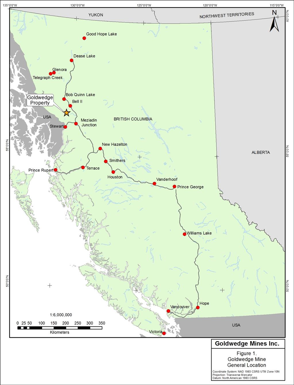
2 TABLE OF CONTENTS TABLE OF CONTENTS... i Figures... i 1. Background... 2 Project Overview... 2 Authorizations, Permits or Approvals... 2 First Nations... 7 Proponent Information Location... 7 General Description... 7 Location Justification... 7 Seasonal Expectations of Use Infrastructure... 8 New Facilities or Infrastructure... 8 Access... 8 Utilities Requirements and Sources... 8 Water Supply... 8 Waste Collection, Treatment and Disposal Environmental Socio-Community FIGURES Figure 1: Goldwedge Mines General Location... 4 Figure 2: Goldwedge Mines Mineral Tenures... 5 Figure 3: Goldwedge Mines Licence of Occupation... 6 SPECTRUM-GJ PROJECT TABLE OF CONTENTS i
3 1. BACKGROUND PROJECT OVERVIEW The following Management Plan is part of Goldwedge Mines Inc. (Goldwedge) application for a Licence of Occupation for Crown Land adjacent to Mine Lease # The Licence of Occupation is needed to support mineral exploration activities authorized under Goldwedge s mineral exploration permit (MX-1-935) and Environmental Management Act (EMA) Waste Discharge Approval The Goldwedge Mine is a privately held mine located in the Northern Boundary Range of the Coast Mountains, approximately 70 kilometers north of Stewart, BC (Figure 1 and Figure 2). The property is above treeline and situated on the west aspect of Brucejack Peak at approximately 1,525 masl (metres above sea level). Surrounded by both the Sulphurets Glacier to the south and west and the Snowfields Glacier to the north and east, the area is heavily glaciated. The Goldwedge property is adjacent to the Brucejack Gold Mine which is currently in operations. The two properties are connected via a tote road and the Brucejack Mine has road access via Special Use Permit Authorization S14912 and SUP The Goldwedge Mine was developed in the late 1980s as an underground gold mine. The previous owner, Catear Resources, had intended to operate the mine at a rate of up to 140 tonnes per day with on-site processing of ore and storage of mine waste (rock and tailings) in Goldpan. Catear Resources constructed mine infrastructure including a mill, camp, ancillary facilities and approximately 300 m of underground workings in the form a spiral decline. Catear Resources initiated a bulk sample (up to 10,000 tonnes of ore) and processed approximately 3,000 tonnes of ore and deposited about the same amount of tailings in Goldpan before shutting the Goldwedge Mine down. Under MX-1-935, Goldwedge has undertaken various exploration activities and site remediation work. In 2017, Goldwedge dewatered the Mine under EMA Waste Discharge Approval For 2018, Goldwedge intends to again dewater the Mine via a water discharge system to Goldpan. The 2018 dewatering plan requires that Approval be amended so that Goldwedge can relocate the water discharge system off the Mine Lease and release mine water to a new location (Goldpan ). Figure 3 presents the area of the Licence of Occupation. AUTHORIZATIONS, PERMITS OR APPROVALS Goldwedge holds the following permits and approvals for the Goldwedge Mine and associated mineral exploration activity: Mine Lease Mineral Exploration Activities and Reclamation Permit MX GOLDWEDGE MINES INC. 2
4 Environmental Management Act (EMA) Waste Discharge Approval GOLDWEDGE MINES INC. 3
5


6 ± Dease!( Goldwedge ALBERTA Property ^_ SG-10 Stewart!( Emerald Smithers Terrace!(!(!( Houston Prince!( Vanderhoof!( Ptarmigan Rupert!( Prince George ^_ Sulphurets Glacier Williams Vancouver!( !( BRITISH COLUMBIA!( Hope East Creek Goldpan Iceberg Beucejack Legend Goldwedge Lease Mining Lease Mineral Cell Title Submission Coordinate System: NAD 1983 UTM Zone 9N Projection: Transverse Mercator Datum: North American 1983 Base Data obtained from: Government of British Columbia GeoBC (TRIM) 1:25, ,000 Meters Goldwedge Mines Inc. Figure 2 Goldwedge Mine Mineral Tenures
7 ± Licence of Occupation m 2 Ptarmigan DL 3357 Goldwedge MC Mill Existing Road Goldpan Claim Information obtained from: BCGov - Mining and Petroleum WMS Base Data obtained from: Government of British Columbia GeoBC and Google Earth Legend Goldwedge Lease Licence of Occupation Contour-m Waterbody Road Water course 1:2, Meters Coordinate System: NAD 1983 UTM Zone 9N Projection: Transverse Mercator Datum: North American 1983 Goldwedge Mines Inc. Licence of Occupation Figure 3
8 FIRST NATIONS As part of the Notice of Work application process for MX-1-935, the following First Nations have been previously notified of mineral exploration activity: Nisga a Nation Tahltan Nation Skii km Lax ha PROPONENT INFORMATION Goldwedge is a private mining company focused on advancing the Goldwedge Mine. Goldwedge mailing and legal address is in Vancouver, British Columbia. John Dupuis is the Operations Director and the main point of contact with government and First Nations and also serves as the designated Mine Manager unless the Ministry is otherwise notified: John Dupuis, Operations Director Goldwedge Mines Inc. jdupuis@goldwedge.ca Suite # West 6 th Ave Vancouver, BC V6H 1A6 2. LOCATION GENERAL DESCRIPTION The Goldwedge Mine is located approximately 70 kilometers north of Stewart, BC (Figure 1). The Goldwedge Mine is approximately 2 km northwest of Brucejack Gold Mine which is currently in operations. The two properties are connected via a tote road and the Brucejack Project has road access via Special Use Permit Authorization S14912 and SUP Goldwedge has had initial discussions with the owner of the Brucejack Project, Pretium Resources Inc., with respect to use of the existing road from Highway 37 to the Brucejack Property. Goldwedge has reengaged Pretium with respect to the use of the access road. Goldwedge will continue to access the property via helicopter until ground access is available. LOCATION JUSTIFICATION The Portal to the Goldwedge Mine drains by gravity into Goldpan and has done so since the Mine shut down in the late 1980s. Goldwedge intends to occupy Crown Land immediately adjacent to Mine Lease to set up a dewatering system (equipment and infrastructure) to allow for the controlled release of mine water from Goldwedge Mine to Goldpan. Goldwedge s current Waste Discharge Approval GOLDWEDGE MINES INC. 7
9 is currently in the amendment process to allow for the discharge of mine water into Goldpan. Currently, the Approval allowed for mine water to be pumped out of the Goldpan drainage into a small gulley to the northwest of the Mine. Goldwedge is seeking this Licence of Occupation and an amendment to Approval to simplify the dewatering process and allow for dewater during winter conditions. SEASONAL EXPECTATIONS OF USE Goldwedge intends to commence site activities and occupy the Crown Land in Q and will continue to occupy the land for the duration of the Licence of the Occupation. 3. INFRASTRUCTURE NEW FACILITIES OR INFRASTRUCTURE Within the area to be occupied, Goldwedge will construct a temporary water holding pond and or ponds to assist with water management prior to release to Goldpan. Goldwedge will also have supplies and reagents that may be used to support the dewatering program. Hoses and pipes will also be used to convey water from the Portal to holding ponds and to Goldpan. Figure 3 presents the area of the Licence of Occupation. Goldwedge may construct up to two wood-framed tents to house equipment and supplies. ACCESS The area is accessed via existing exploration trails that connect the Mine Lease and the area to be occupied. The area is also accessible via a tote road originating from the Brucejack Mine. Brucejack Mine is accessed via an ice road and Forest Service Roads that connect with a provincial highway. UTILITIES REQUIREMENTS AND SOURCES Equipment requiring a power supply will be powered by a small diesel generator located on the Mine Lease. Structures (up to two wood-framed tents) may be equipped with small diesel powered heaters if conditions warrant. WATER SUPPLY Goldwedge will not require a source of water for use within the area of this Crown Land application. WASTE COLLECTION, TREATMENT AND DISPOSAL Domestic and industrial waste from camp and exploration activities will not be stored or disposed of within the area to be occupied. All domestic and industrial waste will be stored on the Mine Lease. GOLDWEDGE MINES INC. 8
10 Sediment collected within the holding ponds will be stored on the Mine Lease prior to relinquishing the Licence of Occupation. GOLDWEDGE MINES INC. 9
11 4. ENVIRONMENTAL Goldwedge anticipates no environmental effects to the Crown Land to be occupied: Vegetation Removal no removal of vegetation Soil Disturbance no soil disturbance Riparian Encroachment no removal of riparian vegetation. Pesticides & Herbicides- no use of pesticides or herbicides Visual Impacts structures to be established on the area to be occupied may be visible by people working at Brucejack Mine. Archaeological Sites Goldwedge understands that heritage resources are protected under the BC Heritage Conservation Act (1996) (HCA). Goldwedge has reviewed the HCA and the Brucejack Gold Mine Environmental Assessment application (Chapter 22 and 29 and Appendix 22-A and 22-B) to gain a better understanding of the archaeological potential of the area and within the limits of the Goldwedge Property as well as mitigation and management options. The archaeological investigations undertaken to support the Brucejack Gold Mine identified nine archaeological sites and two prehistoric archaeological sites in the regional area of the land to be occupied. Goldwedge employees and contractors will be made aware of the archaeological potential of the area during the work training and orientation process. In addition, Goldwedge has developed an Archaeology Chance Find Procedure for employees and contractors. A copy of the Archaeology Chance Find Procedure will be posted at site and made available in hard copy. Construction Methods/Materials Goldwedge intends to construct semi-temporary water holding ponds made of wood and geotextile. As well as wood-framed tent structures. Sound, Odor, Gas or Fuel Emissions little to no sound, odor, gas or fuel emissions are anticipated Tenuring of Aquatic Lands the Crown Land to be occupied includes a portion of Goldpan to support the discharge pipe. Goldpan is non-fish bearing and was used in the late 1980s as a tailings storage facility. Water from the Mine currently drains into Goldpan. Fish & Wildlife Habitat Goldpan and water courses as far downstream of Sulphurates Glacier are non-fish bearing. The area to be occupied is of low wildlife habitat quality and is previously disturbed by historic mining activity. 5. SOCIO-COMMUNITY Land Use it is Goldwedge s understanding that the Crown Land to be occupied overlaps with mineral claim(s) held by Pretium Resources. Socio-Community Conditions, Adjacent Users or Communities outside of the land in question being held GOLDWEDGE MINES INC. 10
12 under a mineral claim, Goldwedge is not aware of any socio-community use of the land or surrounding area. Existing Services there are no services on the Crown Land to be occupied. GOLDWEDGE MINES INC. 11
Rule Governing the Designation and Establishment of All-Terrain Vehicle Use Trails on State Land
 Rule Governing the Designation and Establishment of All-Terrain Vehicle Use Trails on State Land 1.0 Authority 1.1 This rule is promulgated pursuant to 23 V.S.A. 3506. Section 3506 (b)(4) states that an
MANAGEMENT DIRECTION STATEMENT June, 1999
 Thompson River District MANAGEMENT DIRECTION STATEMENT June, 1999 for Roche Lake Provincial Park Ministry of Environment Lands and Parks BC Parks Division Table of Contents I. Introduction A. Setting
FILE: /PERM EFFECTIVE DATE: May 16, 2014 AMENDMENT:
 APPROVED AMENDMENTS: Effective Date Briefing Note /Approval Summary of Changes: FILE: 11000-00/PERM EFFECTIVE DATE: May 16, 2014 AMENDMENT: Table of Contents 1. POLICY APPLICATION... 1 2. PRINCIPLES AND
Decision (Applicant claims urgent public need )
") Decision (Applicant claims urgent public need ) Application: 253 10 Applicant: 457562 BC Ltd. Trade Names: Osoyoos Taxi Address: PO Box 762, Osoyoos BC V0H 1V0 Principals: SINGH, Subag Special Authorization:
Decision (Applicant claims urgent public need ) Application: 253 10 Applicant: 457562 BC Ltd. Trade Names: Osoyoos Taxi Address: PO Box 762, Osoyoos BC V0H 1V0 Principals: SINGH, Subag Special Authorization:
Finn Creek Park. Management Direction Statement Amendment
 Finn Creek Park Management Direction Statement Amendment November 2013 Management Direction Statement Amendment Approved by: Jeff Leahy Regional Director, Thompson Cariboo BC Parks November 12, 2013 Date
Policy PL Date Issued February 10, 2014
 Subject RENEWABLE ENERGY ON CROWN LAND Compiled by Renewable Energy Program, Biodiversity Branch Replaces Policy Directives Waterpower Site Release Crown Land Onshore Windpower Development - Crown Land
Winter Backcountry Recreation Tenure Management Plan June
 Winter Backcountry Recreation Tenure Management Plan June 2 2017 Mike Bromberg President, Revelstoke Backcountry Guides Inc Introduction to Project and Purpose 3 1.0 Seasonal Activities in Proposed Tenure
The original needs analysis carried out in 2001 identified three options for acquiring or leasing land for the crèche:
 5. REDCLIFFS/SUMNER COMMUNITY CRÈCHE RELOCATION Officer responsible Author Property Manager Kevin Mara, DDI 941 6401 The purpose of this report is to update the Council on the status of this project, in
Re: Environmental Assessment Registration Terra Nova Road Quarry File Ref No
 EA Registration Terra Nova Road Quarry File Ref No. 200.20.2528 1 April 3, 2017 The Honourable Eddie Joyce Minister of Municipal Affairs and Environment Department of Municipal Affairs and Environment
REPORT TO THE CHIEF ADMINISTRATIVE OFFICER FROM THE PUBLIC WORKS AND UTILITIES DEPARTMENT
 October 2, 2014 REPORT TO THE CHIEF ADMINISTRATIVE OFFICER FROM THE PUBLIC WORKS AND UTILITIES DEPARTMENT ON KINDER MORGAN PROPOSAL TO ADJUST PROVINCIAL PARK BOUNDARIES WITHIN THE LAC DU BOIS GRASSLANDS
2.0 PARK VISION AND ROLES
 2.0 PARK VISION AND ROLES 2.1 Significance in the Protected Area System Marble Range and Edge Hills provincial parks protect 6.8% of the Pavillion Ranges Ecosection, which is located in the Southern Interior
Coastal Gas Link Project of Trans Canada Pipelines. Community Profile of Stellat en First Nation
 Coastal Gas Link Project of Trans Canada Pipelines Community Profile of Stellat en First Nation What is the Coastal Gas Link Project? Trans Canada Pipeline is planning to build a 650 Km. natural gas pipeline
Perth and Kinross Council Development Control Committee 27 August 2008 Recommendation by Development Quality Manager
 Perth and Kinross Council Development Control Committee 27 August 2008 Recommendation by Development Quality Manager 5(7) 08/414 Erection of kennels and cattery at Baltree Farm, Hatchbank, Kinross, KY13
SECTION: Works & Operations POLICY #: OPS-008. PREPARED BY: Dianna Plouffe PAGE: 1 of 6 Director of Corporate Services
 POLICY: RIVERSIDE MUNICIPAL CAMPGROUND SECTION: Works & Operations POLICY #: OPS-008 PREPARED BY: Dianna Plouffe PAGE: 1 of 6 Director of Corporate Services EFFECTIVE DATE: SUPERSEDES: n/a AUTHORIZED:
Yard Creek Provincial Park. Management Plan
 Yard Creek Provincial Park Management Plan Draft January 2010 Yard Creek Provincial Park Management Plan Approved by: telàlsemkin/siyam/chief Scott Benton Bill Williams Squamish Executive Director ation
Adventure Tourism Management Plan. Adventure Tourism Intensive Use Sites MANAGEMENT PLAN
 Adventure Tourism Intensive Use Sites MANAGEMENT PLAN ACCEPTED BY: FILES #: 1413906 1413905 LICENSES #: 112857 112905 DATE: April 25, 2018 SIGNED on behalf of HER MAJESTRY THE QUEEN IN THE RIGHT OF THE
MILLIGAN HILLS PROVINCIAL PARK
 MILLIGAN HILLS PROVINCIAL PARK PURPOSE STATEMENT AND ZONING PLAN Peace Region 2006 Approved by: Andy Ackerman, Regional Manager Environmental Stewardship Division Peace Region Date: 2006 Nancy Wilkin Assistant
ETOBICOKE CREEK NORTH TRAIL PROJECT. May 18, 2017 at Michael Power High School 105 Eringate Drive, Etobicoke ON M9C 3Z7
 ETOBICOKE CREEK NORTH TRAIL PROJECT May 18, 2017 at Michael Power High School 105 Eringate Drive, Etobicoke ON M9C 3Z7 1 Purpose of Open House The purpose of today s open house is to present the design
Section 61 Recreational Vehicle Park / Campground (Bylaw No. 2012/10)
") Part 7 General Regulations Section 61 Recreational Vehicle Park / Campground (Bylaw No. 2012/10) 61.1 A comprehensive site plan shall be provided to the satisfaction of the Development Authority that shows
Part 7 General Regulations Section 61 Recreational Vehicle Park / Campground (Bylaw No. 2012/10) 61.1 A comprehensive site plan shall be provided to the satisfaction of the Development Authority that shows
5.0 OUTDOOR RECREATION OPPORTUNITIES AND MANAGEMENT
 5.0 OUTDOOR RECREATION OPPORTUNITIES AND MANAGEMENT 5.1 Introduction This section describes the range of recreational activities that currently take place in Marble Range and Edge Hills Parks, as well
4 VIVA PHASE 2 YONGE STREET - Y2, AND HIGHWAY 7 - H3 CORRIDORS PRELIMINARY ENGINEERING UPDATE
 4 VIVA PHASE 2 YONGE STREET - Y2, AND HIGHWAY 7 - H3 CORRIDORS PRELIMINARY ENGINEERING UPDATE The Rapid Transit Public/Private Partnership Steering Committee recommends the following: 1. The presentation
Open Report on behalf of Richard Wills Executive Director for Communities. Planning and Regulation Committee. County Matter Application - S38/0590/13
 Agenda Item 5.10 Report Reference: 5.10 Regulatory and Other Committee Open Report on behalf of Richard Wills Executive Director for Communities Report to: Planning and Regulation Committee Date: 10 June
Welcome KROSNO CREEK DIVERSION PROJECT CLASS ENVIRONMENTAL ASSESSMENT
 Welcome KROSNO CREEK DIVERSION PROJECT PUBLIC INFORMATION CENTRE # 1 Tonight s Presentation Study Overview Background Existing Conditions Alternative Solutions Preliminary Preferred Solution Next Steps
Legend. à à Glacier à à Ã. CRA Tenure Amendment Line CRA Tenure Amendment Area Land File Toby Creek Adventures Tenure Mapping 2016
 500000 550000 CRA Amendment Overview Map Map 1 of 15 5650000 5650000 2 3 Arrow 4 6 5 10 7 9 8 11 Whiteswan Getmapping, Aerogrid, IGN, Alpine 1:400,000 Kilometers 0 10 20 Document Path: P:\16.0002.00_Toby
Chapleau Mining Readiness and Growth Strategy Addendum Number 1 February 27 th, 2017
 kpmg Chapleau Mining Readiness and Growth Strategy Addendum Number 1 February 27 th, 2017 Prepared for: The Chapleau Economic Development Corporation Corporation of the Township of Chapleau 1 Chapleau
EL LIMON MINE: EMPLOYEES & CONTRACTORS 133
 132 EL LIMON MINE: EMPLOYEES & CONTRACTORS 133 B2Gold Employees Direct 552 Nicaraguans 548 Expats 4 Unionized 494 Men 499 Women 53 Contractors Employees 570 Men 529 Women 41 EL LIMON MINE: NICARAGUA OPEN
Vancouver Airport Authority. Contractor Safety Management Program [CSMP] Airside Contractor & Construction Safety
![Vancouver Airport Authority. Contractor Safety Management Program [CSMP] Airside Contractor & Construction Safety](/thumbs/81/83688158.jpg "Vancouver Airport Authority. Contractor Safety Management Program [CSMP] Airside Contractor & Construction Safety") Vancouver Airport Authority Contractor Safety Management Program [CSMP] Airside Contractor & Construction Safety - 2017 CSMP Contractor Expectations - 2017 i Contents Contents Contents Introduction ii
Vancouver Airport Authority Contractor Safety Management Program [CSMP] Airside Contractor & Construction Safety - 2017 CSMP Contractor Expectations - 2017 i Contents Contents Contents Introduction ii
KANANASKIS COUNTRY PROVINCIAL RECREATION AREAS MANAGEMENT PLAN DRAFT TERMS OF REFERENCE - November 20, 2007
 KANANASKIS COUNTRY PROVINCIAL RECREATION AREAS MANAGEMENT PLAN DRAFT TERMS OF REFERENCE - November 20, 2007 BACKGROUND There are 42 Provincial Recreation Areas (PRAs) within Kananaskis Country located
USDA Forest Service Deschutes National Forest DECISION MEMO. Round Lake Christian Camp Master Plan for Reconstruction and New Facilities
 USDA Forest Service Deschutes National Forest DECISION MEMO Round Lake Christian Camp Master Plan for Reconstruction and New Facilities Jefferson County, Oregon T. 13 S., R. 8 E., Section 16, W.M. Background:
ANAGEMENT. LAN November, 1996
 M ANAGEMENT P LAN November, 1996 for Coldwater River Provincial Park Ministry of Environment, Lands and Parks BC Parks Department Coldwater River Provincial Park M ANAGEMENT P LAN Prepared by BC Parks
PRESS RELEASE CANADIAN ZINC SUPPORTS EXPANSION OF NAHANNI NATIONAL PARK
 PRESS RELEASE CZN-TSX CZICF-OTCBB FOR IMMEDIATE RELEASE CANADIAN ZINC SUPPORTS EXPANSION OF NAHANNI NATIONAL PARK PRAIRIE CREEK MINE EXCLUDED FROM ENLARGED PARK ACCESS RIGHTS TO BE PROVIDED BY NEW LEGISLATION
Coronado National Forest Santa Catalina Ranger District
 United States Department of Agriculture Forest Service Coronado National Forest Santa Catalina Ranger District File Code: 1950 Date: October 14, 2015 Dear Interested Party: The Santa Catalina Ranger District
Dease Lake Bob Quinn Lake BRITISH COLUMBIA Meziadin Junction STEWART Cranberry Junction Nass Camp Hazelton New Aiyansh Gitwinksihlkw Kitwanga
 Guide to STEWART Overview Situated across from Alaska s Misty Fiords National Park and at the end of the Portland Canal, Stewart, is a unique border town attracting tourists from every corner of the world.
Appendices for Fox Glacier Heliport Proposal for Hokitika Airport Limited
 Appendices for Fox Glacier Heliport Proposal for Hokitika Airport Limited 1 Survey Plan SO2474 (overview and close view) 2 DOC Map of the site 3 Site Plans 4 Oblique View 5 Site Photos 6 NZTA Access Upgrade
APPENDIX 3-I-B. Alternative Route Assessment Around Provincial Parks and Conservation Reserves
 EAST-WEST TIE TRANSMISSION PROJECT ENVIRONMENTAL ASSESSMENT REPORT APPENDIX 3-I-B Alternative Route Assessment Around Provincial Parks and Conservation Reserves Report No. 1536607/2000/2018 TABLE OF CONTENTS
Roberts Bank Terminal 2 Project
 OCTOBER 2012 Roberts Bank Terminal 2 Project The Roberts Bank Terminal 2 Project is a proposed new multi-berth container terminal at Roberts Bank in Delta, B.C. that would provide 2.4 million TEUs (twenty-foot
Corporate Presentation March 2015
 Corporate Presentation March 2015 March 2015 Serabi Gold and Brazil Serabi Gold plc is dual listed (TSX:SBI, AIM:SRB), gold mining and development company with operations in Northern Brazil. The Company
Prior to contacting the Whitecourt Trailblazers Snowmobile Club, applicants must:
 WHITECOURT TRAILBLAZERS Box 607 Whitecourt, AB T7S 1N7 www.whitecourttrailblazers.ca CNT AMENDMENT Restriction Code 710: See Comments Comments All applicants are required to contact: Whitecourt Trailblazers
Table 1: Iron Mountain Communication Site. Latitude 1 Longitude 1 Elev 2 Address T/R/S 3 APN 4 USGS Quadrangle
 County of Riverside Public Safety Enterprise Communication Project Appendix A: Candidate Site Descriptions Overview The site is located in San Bernardino County near several communication towers in the
Aboriginal Traditional Knowledge
 Aboriginal Traditional Knowledge Manitoba Hydro recognizes the unique relationship Aboriginal communities have with their areas of use and is appreciative to all the communities who took time to share
BHP Billiton Scope 3 emissions
 BHP Billiton Scope 3 emissions The scope 3 emissions associated with BHP Billiton s operations and activities have been calculated using methodologies consistent with the WRI Greenhouse Gas Protocol Corporate
Alternative 3 Prohibit Road Construction, Reconstruction, and Timber Harvest Except for Stewardship Purposes B Within Inventoried Roadless Areas
 Roadless Area Conservation FEIS Summary Table S-1. Comparison of Key Characteristics and Effects by Prohibition Alternative. The effects summarized in this table A would occur in inventoried roadless areas
Outdoor Recreation Opportunities Management
 Outdoor Recreation Opportunities Management Introduction The natural features of Height of the Rockies and Elk Lakes provincial parks provide a wide variety of outdoor recreational activities. However,
Chapter 9: National Parks and Protected Areas
 Part 9.1 Torngat Mountains National Park Reserve 9.1.1 The area set out in the Map Atlas (shown for illustrative purposes only in schedule 9-A) and described in appendix D-2 shall become a National Park
Daisy Dean Trail 628/619 ATV Trail Construction
 Background and Purpose and Need The Daisy Dean ATV Trail Construction Project is located in the Little Belt Mountains, Musselshell Ranger District, Lewis and Clark National Forest approximately 32 miles
Steps in the Management Planning Process
 Steps in the Management Planning Process Developing a management plan for Kalamalka Lake Park will follow a multi-stage process. The planning process for this park is currently in the Draft Management
National Forests and Grasslands in Texas
 United States Department of Agriculture Forest Service National Forests and Grasslands in Texas Sam Houston NF 394 FM 1375 West New Waverly, Texas 77358 Phone 936-344-6205 Dear Friends, File Code: 1950
112th CONGRESS. 1st Session H. R. 113 IN THE HOUSE OF REPRESENTATIVES
 HR 113 IH 112th CONGRESS 1st Session H. R. 113 To provide for additions to the Cucamonga and Sheep Mountain Wilderness Areas in the Angeles and San Bernardino National Forests and the protection of existing
ES Aircraft Deicing Document Identification Number Date: March 15, ) Activity Description:
 Activity Description:") ES-301-1.06 Aircraft Deicing Document Identification Number ES-301-1.06 Date: March 15, 2018 Document Owner: Keith Pass 1) Activity Description: Aircraft deicing is the application of aircraft deicing
ES-301-1.06 Aircraft Deicing Document Identification Number ES-301-1.06 Date: March 15, 2018 Document Owner: Keith Pass 1) Activity Description: Aircraft deicing is the application of aircraft deicing
December 2017 Quarterly Report
 ASX Announcement 31 January 2018 ASX: CRB December 2017 Quarterly Report KEY POINTS Continuation of work including final design criteria and front end engineering following Demonstration Plant test work
Wilderness Areas Designated by the White Pine County bill
 Wilderness Areas Designated by the White Pine County bill SEC. 321. SHORT TITLE. This subtitle may be cited as the `Pam White Wilderness Act of 2006'. SEC. 322. FINDINGS. Congress finds that-- The White
E40. Temporary activities
 E40. Temporary activities E40.1. Background Temporary activities contribute to Auckland's vibrancy and to the social, cultural and economic well-being of communities. Temporary activities also enable filming
Bill S-5: An Act to amend the Canada National Parks Act (Nááts ihch oh National Park Reserve of Canada)
") Bill S-5: An Act to amend the Canada National Parks Act (Nááts ihch oh National Park Reserve of Canada) Publication No. 41-2-S5-E 16 May 2014 Revised 22 October 2014 Penny Becklumb Tim Williams Economics,
Bill S-5: An Act to amend the Canada National Parks Act (Nááts ihch oh National Park Reserve of Canada) Publication No. 41-2-S5-E 16 May 2014 Revised 22 October 2014 Penny Becklumb Tim Williams Economics,
SA"-C.k..try A Approved and Ordered MAR PROVINCE OF BRITISH COLUMBIA ORDER OF LIEUTENANT GOVERNOR IN COUNCIL
 PROVINCE OF BRITISH COLUMBIA ORDER OF LIEUTENANT GOVERNOR IN COUNCIL Order in Council No. 185 Approved and Ordered MAR 2 9 2012 Lieutenant Governor Executive Council Chambers, Victoria On the recommendation
Background Information Document & Invitation to Comment
 Background Information Document & Invitation to Comment Basic Assessment for the Proposed Cultural Tourism Lodge Development at Lake Bhangazi (South), isimangaliso Wetland Park, KwaZulu-Natal Overview
Stuart River Provincial Park Purpose Statement and Zoning Plan
 Stuart River Provincial Park Purpose Statement and Zoning Plan Stuart River Provincial Park protects three-quarters of the 110 kilometer long Stuart River corridor between Stuart Lake and the Nechako River.
Restore and implement protected status that is equivalent, or better than what was lost during the mid-1990 s
 THE ROSSLAND RANGE, OLD GLORY AREA. Executive summary. The Friends of the Rossland Range Society, on behalf of the local outdoor community, seeks to accomplish the following with respect to the Old Glory
A GUIDE TO MANITOBA PROTECTED AREAS & LANDS PROTECTION
 A GUIDE TO MANITOBA PROTECTED AREAS & LANDS PROTECTION Manitoba Wildands December 2008 Discussions about the establishment of protected lands need to be clear about the definition of protection. We will
Port Bruce. Interim Management Statement
 Port Bruce Interim Management Statement Port Bruce Interim Management Statement August 3, 1999 This Port Bruce Provincial Park Interim Management Statement provides direction for the custodial management
REGISTRAR OF PASSENGER TRANSPORTATION MINISTRY OF TRANSPORTATION AND INFRASTRUCTURE
 REGISTRAR OF PASSENGER TRANSPORTATION MINISTRY OF TRANSPORTATION AND INFRASTRUCTURE TEMPORARY OPERATING PERMIT Extra-provincial Undertaking (originating outside of British Columbia) APPLICATION PACKAGE
Bear Creek Habitat Improvement Project
 06/10/10 Bear Creek Habitat Improvement Project El Paso County, Colorado Pike National Forest and Colorado Springs Utilities Owned Land Report prepared by: Eric Billmeyer Executive Director Rocky Mountain
15. BEXLEY RESERVE NORTH AVON BMX CLUB FORMALISATION OF LEASE/LICENCE
 15. BEXLEY RESERVE NORTH AVON BMX CLUB FORMALISATION OF LEASE/LICENCE General Manager responsible: General Manager City Environment, DDI 941-8608 Officer responsible: Authors: PURPOSE OF REPORT Transport
ANAGEMENT P LAN. February, for Elk Lakes and Height of the Rockies Provincial Parks. Ministry of Environment, Lands and Parks BC Parks Division
 M ANAGEMENT P LAN February, 1999 for Elk Lakes and Height of the Rockies Provincial Parks Ministry of Environment, Lands and Parks BC Parks Division Elk Lakes & Height of the Rockies Provincial Parks M
Decision (Applicant claims urgent public need )
") Decision (Applicant claims urgent public need ) Page 1 Application: Applicant: Address: 93-09 UPN Royal City Taxi Ltd. 436 Rousseau St, New Westminster BC V3L 3R3 Principals: GHUMAN, Parambir DHLLON, Chamkaur
Decision (Applicant claims urgent public need ) Page 1 Application: Applicant: Address: 93-09 UPN Royal City Taxi Ltd. 436 Rousseau St, New Westminster BC V3L 3R3 Principals: GHUMAN, Parambir DHLLON, Chamkaur
Application Decision. Application: PO Box 2687, Port Hardy BC V0N 2P0. Special Authorization:
 Application Decision Application: 83 11 Applicant Trade Names: Address: Principals: Special Authorization: Summary: 0825241 BC Ltd Town Taxi PO Box 2687, Port Hardy BC V0N 2P0 WIGARD, Gunnar John Passenger
For personal use only
 For the period ended 30 September 2014 HIGHLIGHTS STORMONT (TASMANIA) JOINT VENTURE GOLD PROJECT MINING AND PRODUCTION COMPLETED. LORENA GOLD PROJECT CONSTRUCTION CONTINUES TO ADVANCE. COMMISSIONING EXPECTED
APPENDIX. Alberta Land Stewardship Act AMENDMENTS TO THE SOUTH SASKATCHEWAN REGIONAL PLAN
 APPENDIX Alberta Land Stewardship Act AMENDMENTS TO THE SOUTH SASKATCHEWAN REGIONAL PLAN 1 All references to Alberta Environment and Sustainable Resource Development, Environment and Sustainable Resource
The Corporation of the Township of Wollaston By-law Being a by-law to licence recreational vehicles and tents in the Township of Wollaston
 By-law 38-17 Being a by-law to licence recreational vehicles and tents in the Township of Wollaston WHEREAS Section 164 of the Municipal Act, 2001 as amended, authorizes the municipality to prohibit or
Case Study: 1. The Clarence River Catchment
 Case Study: 1. The Clarence River Catchment The NSW coastline is a great natural asset, making an enormous contribution to the economy. The resources of coastal catchments such as the Clarence River Catchment,
OIL AND GAS EXPLORATION AND DEVELOPMENT ON PROVINCIAL CROWN LANDS
 NATURAL RESOURCES ENERGY AND MINES July 28, 1997 INFORMATIONAL NOTICE 97-5 Introduction OIL AND GAS EXPLORATION AND DEVELOPMENT ON PROVINCIAL CROWN LANDS This interim informational notice is issued jointly
PROPOSED SAFARI LODGE DEVELOPMENT AND ASSOCIATED INFRASTRUCTURE IN SKUKUZA, KRUGER NATIONAL PARK Background Information Document
 PROPOSED SAFARI LODGE DEVELOPMENT AND ASSOCIATED INFRASTRUCTURE IN SKUKUZA, KRUGER NATIONAL PARK Background Information Document Prepared for: Interested and Affected Parties Prepared by: Exigo Sustainability
ICEFIELDS TRAIL - CONCEPT
 ICEFIELDS TRAIL - CONCEPT Overview: Municipality of Jasper to Columbia Icefield 1 of 21 2 of 21 3 of 21 226 km Start: Municipality of Jasper Legend KM Marker Roads Proposed trail route 16 Jasper Zone 4
APPENDIX 18-D 2010 AND 2011 MOUNTAIN GOAT AERIAL SURVEYS, BRUCEJACK PROJECT
 APPENDIX 18-D 2010 AND 2011 MOUNTAIN GOAT AERIAL SURVEYS, BRUCEJACK PROJECT TM 1. Introduction Mountain goat (Oreamnos americanus) surveys were conducted for the Brucejack Project in 2010 and 2011. The
Santos Tour Down Under Tour Village and Bike Expo
 The Adelaide City Council invites engagement from the community about Santos Tour Down Under Tour Village and Bike Expo Project Summary The Adelaide City Council has received an application from Events
Inter-City Bus (ICB) Application Summary
 Application Summary") Inter-City Bus (ICB) Application Summary Application # 2413-18 Applicant Blue Cactus Coach Lines Ltd. Trade Name (s) Principals Address Current Licence Application Summary Snowbus Joktan Elbert 310-318
Inter-City Bus (ICB) Application Summary Application # 2413-18 Applicant Blue Cactus Coach Lines Ltd. Trade Name (s) Principals Address Current Licence Application Summary Snowbus Joktan Elbert 310-318
PROTECTED AREAS ZONE - POLICY
 PROTECTED AREAS ZONE - POLICY.1 Introduction The Protected Areas Zone applies to the land depicted on the Ruapehu District Plan Maps as: Amenity Policy Area. Protected Areas - Conservation. (c) Protected
Acceptable Practices for Placer Hand Mining South Central Region
 Acceptable Practices for Placer Hand Mining South Central Region Hand work miners are permitted to operate on their placer tenures in-the-dry on unvegetated portions of gravel bars without submitting a
2 YORK REGION TRANSIT VEOLIA AGREEMENT AMENDMENT 91 CALDARI ROAD
 2 YORK REGION TRANSIT VEOLIA AGREEMENT AMENDMENT 91 CALDARI ROAD The Transit Committee recommends the following: 1. Receipt of the presentation by Rick Takagi, Manager, Operations, York Region Transit;
BOULDER CREEK CATTLE FENCING FOR KOKANEE HABITAT ENHANCEMENT 2010
 BOULDER CREEK CATTLE FENCING FOR KOKANEE HABITAT ENHANCEMENT 2010 Prepared for the: FISH & WILDLIFE COMPENSATION PROGRAM, NELSON, B.C. Prepared by: Marc André Beaucher CRESTON VALLEY WILDLIFE MANAGEMENT
JUNE 2017 QUARTERLY ACTIVITIES REPORT
 ASX RELEASE 25 JULY 2017 JUNE 2017 QUARTERLY ACTIVITIES REPORT Cash flow positive result for the quarter even after significant development activities and repayment of Nullagine deferred royalties to the
Airport Master Plan Update June 15, 2017
 Airport Master Plan Update June 15, 2017 www.harveyfield.com The Master Plan is a 20-year plan to understand the needs of current and future users of the Airport. This is important to ensure that safe
Flow Stand Up Paddle Board Parkway Plan Analysis
 Regional Parks Department Jeffrey R. Leatherman, Director County of Sacramento Divisions Administration Golf Leisure Services Maintenance Rangers Therapeutic Recreation Services Flow Stand Up Paddle Board
The following criteria shall be applied within the boundaries of the AO District:
 Sec. 419 (a) Purpose AIRPORT OVERLAY DISTRICT (AO) The purpose of the Airport Overlay District is to regulate and restrict the height of structures, objects, or natural growth, regulate the locations of
General Regulations Governing sawmill, lumber, mining and construction camps
 SAWMILL, LUMBER, MINING AND 1 General Regulations Governing sawmill, lumber, mining and construction camps Repealed by Chapter P-37.1 Reg 10 (effective December 5, 2002). Formerly Saskatchewan Regulations
Railway-Highway Crossing at Grade Regulations: Guidelines for British Columbia s Provincial Heritage Railways
 Railway-Highway Crossing at Grade Regulations: Guidelines for British Columbia s Provincial Heritage Railways SHORT TITLE 1. These Guidelines may be cited as the Railway-Highway Crossing at Grade Guidelines.
Bloor Street West Rezoning Application for a Temporary Use By-law Final Report
 STAFF REPORT ACTION REQUIRED 3741 3751 Bloor Street West Rezoning Application for a Temporary Use By-law Final Report Date: June 12, 2007 To: From: Wards: Reference Number: Etobicoke York Community Council
Big Cook s Pond Cottage Management Plan. Environmental Assessment Registration
 GOVERNMENT OF NEWFOUNDLAND AND LABRADOR Department of Environment and Conservation Lands Branch, Land Management Division Big Cook s Pond Cottage Management Plan Environmental Assessment Registration 1.
Licence Application Decision ICB Simplified Process
 Licence Application Decision ICB Simplified Process Application # 2361-18 Applicant Silver City Stagelines Ltd. Principals Address Fritz Keller 1283 Columbia Ave, Trail, BC, V1R 1J3 Current Licence Passenger
OMINEACA PROVINCIAL PARK
 OMINEACA PROVINCIAL PARK AND PROTECTED AREA PURPOSE STATEMENT AND ZONING PLAN March 2003 OMINECA PROVINCIAL PARK AND PROTECTED AREA Purpose Statement and Zoning Plan Omineca Park and Omineca Protected
NEGOTIATING FOR SUCCESS IN THE COMPETITIVE PORT AND MARINE TERMINAL INDUSTRY
 NEGOTIATING FOR SUCCESS IN THE COMPETITIVE PORT AND MARINE TERMINAL INDUSTRY AAPA Marine Terminal Management Training Program September 18, 2015 Tom Corsie, PPM Vice-President, Real Estate TODAY S AGENDA
Appendix A: San Francisco River Photos Gila National Forest
 Appendix A: San Francisco River Photos Gila National Forest These photos accompany our request for closure to demonstrate both the the outstanding ecological values associated with this area, as well as
White Mountain National Forest Saco Ranger District
 United States Department of Agriculture Forest Service White Mountain National Forest 33 Kancamagus Highway Conway, NH 03818 Comm: (603) 447-5448 TTY: (603) 447-3121 File Code: 1950 Date: February 26,
HUT POINT, ROSS ISLAND
 Measure 2 (2005) Annex K Management Plan for Antarctic Specially Protected Area No. 158 HUT POINT, ROSS ISLAND (including Historic Site and Monument No. 18, the historic Discovery hut of Captain R F Scott)
VANCOUVER AIRPORT AUTHORITY TARIFF OF FEES AND CHARGES Effective January 1, 2019 Subject to Change PAYMENT TERMS AND CONDITIONS
 PAYMENT TERMS AND CONDITIONS All fees and charges payable by an air carrier under the Tariff will be invoiced by the Airport Authority and invoiced amounts will be payable by the air carrier on the following
SKEENA TAXI LTD Saskatoon Avenue, Prince Rupert, BC V8J 4J1
 Application Decision Application: 2461-07 Applicant: Address: Page 1 SKEENA TAXI LTD. 1047 Saskatoon Avenue, Prince Rupert, BC V8J 4J1 Principals: DIDYCHUK, Joseph GILL, Lakhvir Special Authorization:
MANAGEMENT DIRECTION STATEMENT
 Skeena District MAAGEMET DIRECTIO STATEMET July, 2000 for Driftwood Canyon Provincial Park Ministry of Environment Lands and Parks BC Parks Division i Table of Contents Driftwood Canyon Park Approvals
Newcastle Transport Program Newcastle Light Rail Determination Report
 Newcastle Transport Program Newcastle Light Rail Determination Report Date Author 25 July 2016 TfNSW Ref 5276649 Status Final TfNSW 2014 UNCONTROLLED WHEN PRINTED Page 1 of 19 Table of contents 1 Introduction
MANAGEMENT DIRECTION STATEMENT March 2003
 Skeena Region MAAGEMET DIRECTIO STATEMET March 2003 for Meziadin Lake Provincial Park Ministry of Water, Land and Air Protection Environmental Stewardsh Division This page left blank on purpose ii Table
Mackinnon Esker Ecological Reserve Draft - Management Plan
 Mackinnon Esker Ecological Reserve Draft - Management Plan May 2011 Photo Credit: This document replaces the direction provided in the Carp Lake Provincial Park and Protected Area and Mackinnon Esker Ecological
Old Limberlost Sports Club, Butlers Road, Handsworth Wood, Birmingham, B20 2NT
 Committee Date: 07/03/2013 Application Number: 2012/07986/PA Accepted: 29/11/2012 Application Type: Variation of Condition Target Date: 24/01/2013 Ward: Handsworth Wood Old Limberlost Sports Club, Butlers