Dumont Dunes Special Recreation Management Area (SRMA)
|
|
|
- Kelley Jack Wilkins
- 6 years ago
- Views:
Transcription
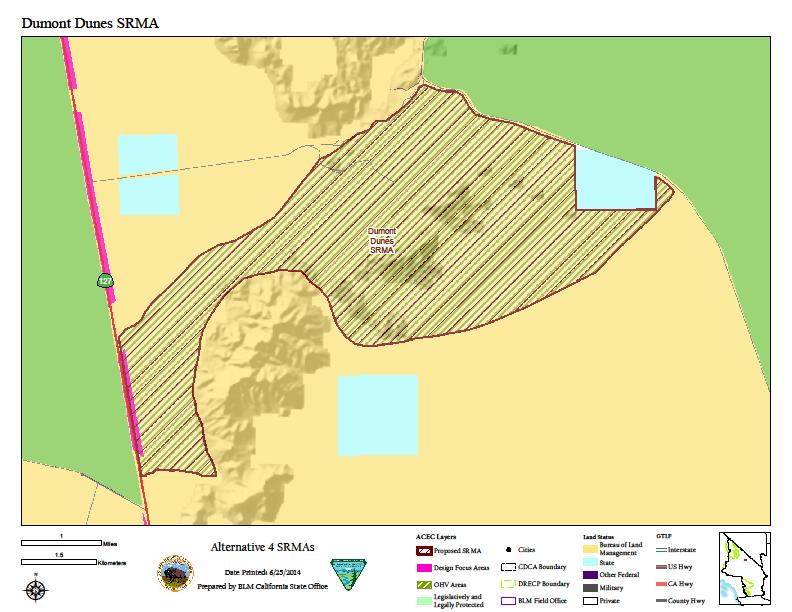
1 Dumont Dunes Special Recreation Management Area (SRMA) RMA/RECREATION MANAGEMENT ZONE (RMZ) OBJECTIVE(S) DECISIONS Objective Statement: Designate this area as a Special Recreation Management Area. To manage the Dumont Dunes SRMA for the unique opportunity at Dumont Dunes for motorized recreation, including continued development of on-site visitor services, as well as the non-motorized opportunities in the adjacent Salt Creek ACEC as well as other adjacent areas. Activities: Casual recreation involving motorized vehicles is the main activity at Dumont Dunes OHV Recreation Area, and along the connecting designated open routes. Visitors ride all types of motorized vehicles specially built or modified for sand based recreation; plus camping, scenic touring, trail riding, and dune play. Activities include special & competitive events; family, friend and club gatherings; amateur, student & commercial filming and photography. Hiking, wildflower viewing, picnicking and exploring historic ruins, mines & trails is popular in the adjacent Salt Creek cultural ACEC. Southern portion of the area includes Silurian Dry Lake, designated open for all types of vehicles, motorized & nonmotorized; occasional use includes land sailing and model airplanes. Scenic touring and trail riding are popular on the T & T historic railroad grade and along Kingston Wash Route; connecting the Silurian Dry Lake area with the Dumont Dunes & Amargosa areas. Silurian Dry Lake is designated open for all types of activities. Experiences: Visitors frequent Dumont Dunes for primarily the unique large sand fields here which are relatively stable. Even though the visitors are split between those from American and those from abroad, they are also split between California & Nevada, who come to experience this beautiful & remote dune system nature. They come here to be and ride together with family, friends and like-minded people. A major draw for this site is the remote nature and dark skies. International travelers typically stop for a micro desert experience in the OHV off-season between May & Oct, generally shooting pics, hiking & visiting for under 2 hours. Similar pattern occurs by American travelers during fall, winter & spring. The latter visitors more frequently visit the Salt Creek area and hike the trails seeking to understand the lifestyle & experiences of desert natives, explorers, miners, emigrants and residents; precipitating feelings of remoteness, helplessness and feeling small & insignificant. The long distance trail opportunities provide people a sense of freedom and openness to explore and go into desolate areas. Benefits: This area provides personal benefits that are tied to personal accomplishment and perseverance in this remote and inhospitable environment. Individuals are challenged to build, borrow, buy, modify or rent vehicles to travel here; everything about coming here is difficult and the rewards are increased self-worth, trust, an expanded capacity to travel & experience other areas. This area contributes to community, social, economic and environmental benefits because it generates tourism in this remote area with few roads & services. This SRMA provides connectivity among areas & trails, in location & time, providing outstanding motorized riding & touring experiences. Here people learn to appreciate the subtle links and connections between all living things and water. In this stark landscape people become aware and grow to appreciate the beauty, creativity & tenacity of nature; leading to feelings of well-being and inspiration for life. This area provides a relatively safe & easy setting to direct legal motorized OHV play and therefore reduces pressure & potential impacts to sensitive areas.
2 RECREATION SETTING CHARACTERISTICS (RSC) DESCRIPTIONS Physical Components: This SRMA has qualities of the landscape fitting the Front Country Classification. Dumont Dunes are completely natural and are set in one of the more remote regions of the Mojave Desert, on the eastern side of Death Valley. The Amargosa River & Old Spanish NHT border the dunes on the north & west (follows Highway 127), the east and south are wilderness; the historic T & T railroad grade serves as the north-east boundary and a motorized access route for 4 x 4 exploration & scenic touring. Facilities include signs, main access road with low water crossing, vault toilets, vehicle barriers, entry station, command post and visitor contact station. A campground host is typically here throughout the season. Salt Creek developments include 2 parking areas with interpretive kiosks & vault toilets connected by trail through historic ruins; includes one of county s oldest structures. Silurian Dry Lake is completely natural; this is typically the first lakebed to dry up following rain events. Outstanding views of ancient, historic & scenic landscapes surround the area. This area is very hot and arid, summer temperatures between 100 and 120, winter lows are freezing. Social Components: The qualities of the social component of this area fit the Front Country Classification. The dune visitors are a smaller and closer knit sub-group of the OHV riding population, they tend to congregate in larger numbers but less frequently. The access roads and vault toilets are spread out along the foot of the dunes allowing visitors to stake out a large area for their group on a first come first serve basis. The majority of campsites consist of several motorhomes & tents, with groups between 5 & 15 vehicles common. Visitors celebrate Thanksgiving in the traditional way, resulting in high day use from family members converging for complete holiday diner in camp. The dune visitor & administrative facilities, plus the vendors, are arranged near the entrance for ease of access. The Salt Creek area is a popular stop with touring groups of international visitors riding street motorcycles; European travelers, and American s viewing wildflowers: a wide spectrum of long-distance travelers. Visitors enjoying the connecting routes usually venture out in clubs and small groups of family & friends. Operational Components: The operational component conditions in this area also rate the Front Country Classification. The area is accessed by progressively smaller roads, from interstate 15, to state highway 127, to the dunes dirt access road. Visitor use in this SRMA is concentrated along the Highway 127 corridor between Silurian Dry Lake and Dumont Dunes. The dunes road is all weather with a low water crossing over the Amargosa River at the lower end of the wild and scenic river segment. Facilities include kiosks, a small visitor center, pads for portable trailers, generator shop, lighting, vault toilet & heliport. Visitor services staff and law enforcement Rangers work weekends and intermittently during the week from fall to winter. Additional staffing is provided on major holiday weekends and during special events. Protective fencing runs along portions of the dunes boundary, and the remainder is signed. Most of Salt Creek is fenced and mines in the area are sealed with bat grates. MANAGEMENT ACTIONS & ALLOWABLE USES Recreation and Visitor Services Program: Adjust the boundaries and land stewardship to accommodate intensive sand dune recreation & compatible desert uses; provide information and assistance to enhance visitor safety and knowledge of hazards; construct and maintain minimum
3 visitor facilities to provide primitive, yet safe & healthy conditions; utilize Special Recreation Fee Program to provide services to the public. Allow special and competitive events; manage as VRM class II; provide law enforcement and visitor services staffing. Prohibit motorized access and camping in the adjacent Salt Creek ACEC area; except for the access road. Maintain access to the OHV area from Sperry Wash, T & T, and Kingston Wash Routes as designated open routes providing connectivity for motorized and mechanized uses as designated in NEMO TTMP. Manage all routes of travel as open, limited or closed, as designated in the NEMO TTMP. Acres by Alternative on BLM Lands: No Action Preferred Alternative Other Programs: Renewable energy development is not an allowable use in SRMAs due to the incompatibility with the values of the SRMA. Two exceptions to this management action are: 1) geothermal development is an allowable use if a geothermal-only DFA overlays the SRMA designation and complies with a no surface occupancy restriction; and, 2) in the Preferred Alternatives if a DRECP variance land designation overlays the SRMA, renewable energy may be allowed on a case-by-case basis if the proposed project is found to be compatible with the specific SRMA values. Implementation Decisions: Provide on & off-site interpretive programs; construct info kiosks on entry roads; print & distribute site flyer; post traffic control & direction signs along access road; issue vending permits for recreation goods; post primary access roads with visibility markers; designate & post entry road for street legal vehicles only; develop command post along the access road at top of the mesa, include visitor contact & first aid stations, equipment & temporary staff housing, protective fencing & heliport. Require use of whip flags; prohibit burning wood w/nails & glass beverage containers; prohibit camping along access road & river. An activity level plan would be developed to identify and designate current and future recreational opportunities, appropriate facilities to provide for and manage the proposed uses, parameters for streamlined Special Recreation Permitting of recreation events, staffing and funding needs, parameters for facility and road/trail maintenance, partnerships, possible recreation fee considerations, and an implementation schedule. Mitigation: 1. Maintain through traffic motorized route network connectivity with roads and trails leading into and through the Dumont Dunes SRMA. 2. Manage renewable energy development on adjacent and nearby lands to avoid traffic conflicts with visitors & permitted uses.
4 The information and maps shown on this system should be used for planning purposes only. It should not be the sole source for determining map boundary locations.
5
6
7
8
I Land Status. Santa Rosa Mountains
 Please note this comparative evaluation provides an illustrative view into the data, information and type of analyses that will be presented 62 62 10 10 111 243 74 10 243 74 74 10 74 10 74 Santa Rosa Mountains
Final Recreation Report. Sunflower Allotment Grazing Analysis. July 2015
 Final Recreation Report Sunflower Allotment Grazing Analysis July 2015 Table of Contents Introduction... 3 Affected Environment... 3 Four Peaks Wilderness Area... 3 Dispersed Recreation... 3 Environmental
Recreation Opportunity Spectrum for River Management v
 Recreation Opportunity Spectrum for Management v. 120803 Introduction The following Recreation Opportunity Spectrum (ROS) characterizations and matrices mirror the presentation in the ROS Primer and Field
RECREATION. Seven issues were identified that pertain to the effects of travel management on outdoor recreation within portions of the project area.
 RECREATION Seven issues were identified that pertain to the effects of travel management on outdoor recreation within portions of the project area. OPPORTUNITIES FOR SOLITUDE / QUIET TRAILS. One attraction
PURPOSE AND NEED. Introduction
 Public Scoping: Allocation of Recreation Capacity for Commercial Outfitter Guide Services on North Kruzof Island Trails (Kruzof Island Outfitter Guide) PURPOSE AND NEED Introduction The U.S. Department
Theme: Predominately natural/natural appearing; rustic improvements to protect resources. Size*: 2,500 + acres Infrastructure**:
 Recreation Opportunity Spectrum (ROS) Classes The Recreation Opportunity Spectrum (ROS) provides a way to describe the variations in the degree of isolation from the sounds and influences of people, and
Yard Creek Provincial Park. Management Plan
 Yard Creek Provincial Park Management Plan Draft January 2010 Yard Creek Provincial Park Management Plan Approved by: telàlsemkin/siyam/chief Scott Benton Bill Williams Squamish Executive Director ation
Kelly Motorized Trails Project Proposed Action
 Kelly Motorized Trails Project Proposed Action November 28, 2011 The Flagstaff Ranger District of the Coconino National Forest is seeking public input on the proposed Kelly Motorized Trails Project (formerly
APPENDIX E - STRUCTURE RECREATION MANAGEMENT AREAS -SRMAS
 APPENDIX E - STRUCTURE RECREATION MANAGEMENT AREAS -SRMAS Appendix E Structured Recreation Management Areas Page E-1 Table of Contents Cortez Structured Management Area...2 Recreation Management Zone
BUTTE COUNTY FOREST ADVISORY COMMITTEE
 BUTTE COUNTY FOREST ADVISORY COMMITTEE November 24, 2014-4:00 P.M. ITEM NO. 1.00 2.00 Call to order Golden Valley Bank, 190 Cohasset Rd. Chico, CA 95926 (park in center of lot) Pledge of allegiance to
Preferred Recreation Recommendations Stemilt-Squilchuck Recreation Plan March 2018
 Preferred Recreation Recommendations Stemilt-Squilchuck Recreation Plan March 2018 Below are the recommended recreation ideas and strategies that package together the various recreation concepts compiled
Continental Divide National Scenic Trail Legislative History and Planning Guidance
 Continental Divide National Scenic Trail Legislative History and Planning Guidance Legislation, Policy, and Direction Regarding National Scenic Trails The National Trails System Act, P.L. 90-543, was passed
13.1 REGIONAL TOURISM ISSUES AND SUMMARY OF FINDINGS
 13 REGIONAL TOURISM T he County of Mariposa s recreation needs and facilities fall within two categories: regional tourism and local recreation. This Element focuses on regional tourism issues related
WORKSHEET 1 Wilderness Qualities or Attributes Evaluating the Effects of Project Activities on Wilderness Attributes
 WORKSHEET 1 Wilderness Qualities or Attributes Evaluating the Effects of Project Activities on Wilderness Attributes Date: 3/7/2017 Roadless Area: Ruby South Description of Project Activity or Impact to
APPENDIX C RECREATION OPPORTUNITY SPECTRUM PROCESS AND CLASSES
 APPENDIX C RECREATION OPPORTUNITY SPECTRUM PROCESS AND CLASSES RECREATION OPPORTUNITY SPECTRUM PROCESS Recreation area management objectives are defined through a planning process referred to as the Recreation
Appendix A BC Provincial Parks System Goals
 Appendix A BC Provincial Parks System Goals The British Columbia Provincial Parks System has two mandates: To conserve significant and representative natural and cultural resources To provide a wide variety
FINAL TESTIMONY 1 COMMITTEE ON RESOURCES UNITED STATES HOUSE OF REPRESENTATIVES. July 13, 2005 CONCERNING. Motorized Recreational Use of Federal Lands
 FINAL TESTIMONY 1 STATEMENT OF DALE BOSWORTH CHIEF Of the FOREST SERVICE UNITED STATES DEPARTMENT OF AGRICULTURE Before the SUBCOMMITTEE ON FORESTS AND FOREST HEALTH And the SUBCOMMITTEE ON NATIONAL PARKS,
Logo Department Name Agency Organization Organization Address Information 5700 North Sabino Canyon Road
 Logo Department Name Agency Organization Organization Address Information United States Forest Coronado National Forest 5700 North Sabino Canyon Road Department of Service Santa Catalina Ranger District
Existing Resource Information
 Botanical and Wildlife Vegetation alliances/wildlife habitats Grasslands annual/perennial Chaparral mixed/montane/chamise-redshank Riparian montane/valley foothill riparian Sierran mixed conifer Montane
Accessibility Guidelines for Outdoor Recreation and Trails
 Accessibility Guidelines for Outdoor Recreation and Trails Association of Conservation Engineers September 17, 2007 Accessibility Guidelines for Outdoor Recreation and Trails Access Board is the independent
Creating a User-Driven Long-Distance OHV Trail Through Partnering
 Joseph Raffaele Outdoor Recreation Planner U.S. Bureau of Land Management Yuma, Arizona Creating a User-Driven Long-Distance OHV Trail Through Partnering BLM is a multiple-use land management agency within
PROPOSAL FOR RECLASSIFICATION, BOUNDARY AMENDMENT AND DRAFT CONCEPT PLAN FOR SASKATOON MOUNTAIN NATURAL AREA. Frequently Asked Questions
 PROPOSAL FOR RECLASSIFICATION, BOUNDARY AMENDMENT AND DRAFT CONCEPT PLAN FOR SASKATOON MOUNTAIN NATURAL AREA 1. Why is this proposal being put forward? Frequently Asked Questions For many years, Alberta
3.7 BLM Land Designations, Classifications, Allocations, and Wilderness Inventory
 3.7 BLM Land Designations, Classifications, Allocations, and Wilderness Inventory 3.7.1 Regulatory Setting, Planning, and Policy Guidance 3.7.1.1 Federal Land Policy and Management Act of 1976 Enacted
RED MOUNTAIN HISTORIC DISTRICT ENHANCEMENT Grand Mesa, Uncompahgre, Gunnison National Forests Ouray Ranger District
 RED MOUNTAIN HISTORIC DISTRICT ENHANCEMENT Grand Mesa, Uncompahgre, Gunnison National Forests Ouray Ranger District Project Summary The Red Mountain President s Initiative Project proposes a comprehensive
Superintendent David Uberuaga June 27, 2011 Grand Canyon National Park P.O. Box 129 Grand Canyon, AZ 86023
 Superintendent David Uberuaga June 27, 2011 Grand Canyon National Park P.O. Box 129 Grand Canyon, AZ 86023 Dear Superintendent Uberuaga, Thank you for the opportunity to provide scoping comments on Grand
SIMON CANYON AREA OF CRITICAL ENVIRONMENTAL CONCERN (ACEC)
") SIMON CANYON AREA OF CRITICAL ENVIRONMENTAL CONCERN (ACEC) Activities: Facilities: Season / Hours: Description: Hiking, backpacking, fishing, picnicking, watchable wildlife. A graveled parking area, picnic
SIMON CANYON AREA OF CRITICAL ENVIRONMENTAL CONCERN (ACEC) Activities: Facilities: Season / Hours: Description: Hiking, backpacking, fishing, picnicking, watchable wildlife. A graveled parking area, picnic
Special Recreation Management Areas Extensive Recreation Management Areas Public Lands Not Designated as Recreation Management Areas
 From the Proposed RMP: Special Recreation Management Areas SRMAs are an administrative unit where the existing or proposed recreation opportunities and recreation setting characteristics are recognized
S Central Coast Heritage Protection Act APRIL 21, 2016
 STATEMENT OF GLENN CASAMASSA ASSOCIATE DEPUTY CHIEF, NATIONAL FOREST SYSTEM U.S. FOREST SERVICE U.S. DEPARTMENT OF AGRICULTURE BEFORE THE UNITED STATES SENATE COMMITTEE ON ENERGY AND NATURAL RESOURCES
AMERICAN S PARTICIPATION IN OUTDOOR RECREATION: Results From NSRE 2000 (With weighted data) (Round 1)
 (Round 1)") AMERICAN S PARTICIPATION IN OUTDOOR RECREATION: Results From NSRE 2000 (With weighted data) (Round 1) The emphasis of this report is on participation patterns across activities and segments of our society.
AMERICAN S PARTICIPATION IN OUTDOOR RECREATION: Results From NSRE 2000 (With weighted data) (Round 1) The emphasis of this report is on participation patterns across activities and segments of our society.
4.0 OUTDOOR RECREATION 4.1 PUBLIC LANDS
 4.0 OUTDOOR RECREATION 4.1 PUBLIC LANDS Public lands provide a wide range of recreational opportunities and are considered a valuable community asset. There may be seasonal and/or other use restrictions
Steer Creek Campground Corral
 Steer Creek Campground Corral Purpose and Need The purpose of this project is to increase the availability of camping experiences and services for equestrians at the Steer Creek Campground in the Samuel
Section 3.6 Recreation
 3.6 RECREATION This section evaluates the potential impacts of the proposed project on recreation within MTRP. The evaluation is based on field observations, a review of maps of MTRP and the MTRP Master
Rogue River Access and Management Plan Draft Alternatives
 Rogue River Access and Management Plan Draft Alternatives The Rogue River Access and Management Plan was initiated in December, 2011 and is being led by Jackson County Parks (JCP) and Oregon Department
TABLE COUNTY REGIONAL PARKS AND COMMUNITY PARKS IN THE DESERT REGION
 The purpose of this Section is to identify existing recreation opportunities within the Project area, analyze potential impacts to recreation associated with the development of the proposed Project, and
Outdoor Recreation Opportunities Management
 Outdoor Recreation Opportunities Management Introduction The natural features of Height of the Rockies and Elk Lakes provincial parks provide a wide variety of outdoor recreational activities. However,
ANGEL PEAK SCENIC AREA
 Activities: Facilities: ANGEL PEAK SCENIC AREA Hiking, photography, watchable wildlife, camping, picnicking. Note: While formal hiking trails in the area are limited, dispersed hiking opportunities abound
2.0 PARK VISION AND ROLES
 2.0 PARK VISION AND ROLES 2.1 Significance in the Protected Area System Marble Range and Edge Hills provincial parks protect 6.8% of the Pavillion Ranges Ecosection, which is located in the Southern Interior
2019 Work Week Crew. Schedule and Descriptions
 2019 Work Week Crew WAWONA WW1 Mariposa Grove Restoration and Invasive Plant Removal June 2 June 8 YOSEMITE VALLEY YV1 Washington Column Climber s Trail Rehabilitation June 9 June 15 YV2 Weed Warriors/
SOUTH INTERCHANGE AREA
 Santaquin City General Plan 1 Location and Characteristics The South Interchange Area of Santaquin is located west of Interstate 15 and south of 500 South (Figure 1). It includes properties already annexed
Non-motorized Trail Plan & Proposal. August 8, 2014
 Town of Star Valley Ranch, Wyoming and the Star Valley Ranch Association in partnership with the USDA Forest Service, Bridger-Teton National Forest, Greys River Ranger District Non-motorized Trail Plan
Oceano Dunes SVRA (Pismo Beach)
") SCLR Event Oceano Dunes SVRA (Pismo Beach) September 19-20, 2009 When: Where: What: September 19 nd and 20 th Oceano Dunes SVRA Pismo Beach, California Sand Dunes, camping, games, food, driving challenges,
SCLR Event Oceano Dunes SVRA (Pismo Beach) September 19-20, 2009 When: Where: What: September 19 nd and 20 th Oceano Dunes SVRA Pismo Beach, California Sand Dunes, camping, games, food, driving challenges,
Table 3-7: Recreation opportunity spectrum class range by prescription. Recreation Opportunity Spectrum (ROS) Classes
 Classes") Appendix F Table -7: Recreation opportunity spectrum class range by prescription. Recreation Opportunity Spectrum (ROS) Classes Prescription Primitive Primitive II Roaded Modified Rural Urban 111 - Primitive
Appendix F Table -7: Recreation opportunity spectrum class range by prescription. Recreation Opportunity Spectrum (ROS) Classes Prescription Primitive Primitive II Roaded Modified Rural Urban 111 - Primitive
National Forests and Grasslands in Texas
 United States Department of Agriculture Forest Service National Forests and Grasslands in Texas Sam Houston NF 394 FM 1375 West New Waverly, Texas 77358 Phone 936-344-6205 Dear Friends, File Code: 1950
Fossil Creek Wild & Scenic River Comprehensive River Management Plan Forest Service Proposed Action - details March 28, 2011
 Fossil Creek Wild & Scenic River Comprehensive River Management Plan Forest Service Proposed Action - details March 28, 2011 Primary Goals of the Proposed Action 1. Maintain or enhance ORVs primarily by
Bureau of Land Management Public Lands Guide Northwest District
 Bureau of Land Management Public Lands Guide Northwest District NORTHWEST Fee Site Restrooms Picnic Sites Developed Campgrounds Farmington Field Office (505) 564-7600 Alien Run Mountain Bike Trail Angel
5.0 OUTDOOR RECREATION OPPORTUNITIES AND MANAGEMENT
 5.0 OUTDOOR RECREATION OPPORTUNITIES AND MANAGEMENT 5.1 Introduction This section describes the range of recreational activities that currently take place in Marble Range and Edge Hills Parks, as well
The following criteria shall be applied within the boundaries of the AO District:
 Sec. 419 (a) Purpose AIRPORT OVERLAY DISTRICT (AO) The purpose of the Airport Overlay District is to regulate and restrict the height of structures, objects, or natural growth, regulate the locations of
Salt River Allotments Vegetative Management EIS Draft Recreation Affected Environment Report Don R. Sullivan November 6, 2012
 Salt River Allotments Vegetative Management EIS Draft Recreation Affected Environment Report Don R. Sullivan November 6, 2012 Introduction The area surrounding the Salt River Canyon, the Salt River Canyon
CHAPTER III: TRAIL DESIGN STANDARDS, SPECIFICATIONS & PERMITS
 CHAPTER III Trail Design Standards, Specifications & Permits This chapter discusses trail standards, preferred surface types for different activities, permits, and other requirements one must consider
Alternative 3 Prohibit Road Construction, Reconstruction, and Timber Harvest Except for Stewardship Purposes B Within Inventoried Roadless Areas
 Roadless Area Conservation FEIS Summary Table S-1. Comparison of Key Characteristics and Effects by Prohibition Alternative. The effects summarized in this table A would occur in inventoried roadless areas
Connie Rudd Superintendent, Black Canyon of the Gunnison National Park
 National Park Service U.S. Department of the Interior Black Canyon of the Gunnison National Park and Curecanti National Recreation Area Information Brochure #1 Wilderness and Backcountry Management Plan
Proposal to Redevelop Lower Kananaskis River-Barrier Lake. Bow Valley Provincial Park. Frequently Asked Questions
 Proposal to Redevelop Lower Kananaskis River-Barrier Lake Bow Valley Provincial Park Frequently Asked Questions What is being proposed? What are the details of the proposal? Where is the project area located?
LIST OF LOCAL SIGHTS AND RECREATION
 LIST OF LOCAL SIGHTS AND RECREATION Pictures of Klamath Falls - http://members.spree.com/sip/sunnidaze/me/kfalls.html One of the local members of Kingsley Field took some pictures of the local area in
Buford / New Castle Motorized Trail
 Buford / New Castle Motorized Trail Rifle Ranger District, White River National Forest Garfield County, Colorado Comments Welcome The Rifle Ranger District of the White River National Forest welcomes your
MANAGEMENT DIRECTION STATEMENT June, 1999
 Thompson River District MANAGEMENT DIRECTION STATEMENT June, 1999 for Roche Lake Provincial Park Ministry of Environment Lands and Parks BC Parks Division Table of Contents I. Introduction A. Setting
Recreation Effects Report Travel Management
 United States Department of Agriculture Forest Service Southwestern Region Recreation Effects Report Travel Management Camino Real Ranger District Carson National Forest September 2013 /s/ Kathryn Furr
Arthur Carhart National Wilderness Training Center s Wilderness Investigations High School
 Arthur Carhart National Training Center s Investigations High School 101/Lesson 2 (OPTION 2B) Introducing the Act Goal: Students will understand the difference between wild spaces and federally designated
TRAILS WHERE TO FIND TRAILS IN NOVA SCOTIA
 TRAILs SIGNAGE Know the Signs............................ 44 WHERE YOU CAN RIDE Roads and Highways........................ 46 Designated Trails........................... 47 Established Trails...........................
System Group Meeting #1. March 2014
 System Group Meeting #1 March 2014 Meeting #1 Outcomes 1. Understand Your Role 2. List of Revisions to Existing Conditions 3. Information Sources Study Area The Purpose of Mountain Accord is to Preserve
National Wilderness Steering Committee
 National Wilderness Steering Committee Guidance White Paper Number 1 Issue: Cultural Resources and Wilderness Date: November 30, 2002 Introduction to the Issue Two of the purposes of the National Wilderness
ROBERTS CREEK PROVINCIAL PARK MASTER PLAN. November, 1981
 Ministry of Lands, Parks and Housing Parks and Outdoor Recreation Division Park Operations Branch North Vancouver, B. C. ROBERTS CREEK PROVINCIAL PARK MASTER PLAN November, 1981 Mr. G. Trachuk Director
KANANASKIS COUNTRY PROVINCIAL RECREATION AREAS MANAGEMENT PLAN DRAFT TERMS OF REFERENCE - November 20, 2007
 KANANASKIS COUNTRY PROVINCIAL RECREATION AREAS MANAGEMENT PLAN DRAFT TERMS OF REFERENCE - November 20, 2007 BACKGROUND There are 42 Provincial Recreation Areas (PRAs) within Kananaskis Country located
Camping (Primitive) Camping (RV) Electrical Potable Water Grill Established Fire Pit Picnic Table
 Camping (RV) Electrical Potable Water Grill Established Fire Pit Picnic Table") Alden - 9th Road River Mile 777 Map: 38.20833, -98.32031 Managing Agency: Kansas Department of Wildlife, Parks & Tourism Nearest Community: Alden, Rice County Kansas Developed Amenities Provided Parking
Alden - 9th Road River Mile 777 Map: 38.20833, -98.32031 Managing Agency: Kansas Department of Wildlife, Parks & Tourism Nearest Community: Alden, Rice County Kansas Developed Amenities Provided Parking
EMERY COUNTY PUBLIC LAND MANAGEMENT ACT OF 2018 S. 2809/H.R. 5727
 EMERY COUNTY PUBLIC LAND MANAGEMENT ACT OF 2018 S. 2809/H.R. 5727 September 25, 2018 OVERVIEW The Emery County Public Land Management Act of 2018 is a significant step backwards for wilderness and conservation
Summer 2013 Dalton Highway Recreation Study
 Summer 2013 Dalton Highway Recreation Study Implications for Recreation and Visitor Services Planning Peter J Fix School of Natural Resources and Extension University of Alaska Fairbanks OLLI Session 2
As outlined in the Tatshenshini-Alsek Park Management Agreement, park management will:
 Management Strategy General Strategy The priority management focus for the park is to ensure that its internationally significant natural, cultural heritage and recreational values are protected and that
COMMERCIAL LAND FOR SALE ACRES Interstate 15 Freeway and Baker Blvd. Baker CA.
 68.85 ACRES SITE EXIT TO DEATH VALLEY NATIONAL PARK Future Alien Hotel Development TO LAS VEGAS PROPERTY: 73160 Baker Blvd., Baker CA SIZE: 68.85 Acres 2,999,541 Sq Ft PRICE: $2,400,000.00 TO LOS ANGELES
Desert Wildflower Superbloom and Southwest Arizona Sites (A17A)
") Desert Wildflower Superbloom and Southwest Arizona Sites (A17A) In Fall 2016 I traveled to Anza-Borrego Desert State Park in southern California for a couple days of hiking and exploration. I originally
Desert Wildflower Superbloom and Southwest Arizona Sites (A17A) In Fall 2016 I traveled to Anza-Borrego Desert State Park in southern California for a couple days of hiking and exploration. I originally
Clearwater Lake Provincial Park. Draft Management Plan
 Clearwater Lake Provincial Park Draft Management Plan Clearwater Lake Provincial Park Draft Management Plan Table of Contents 1. Introduction... 3 2. Park History... 4 3. Park Attributes... 4 3.1 Location/Access...4
United States Department of the Interior Bureau of Land Management
 United States Department of the Interior Bureau of Land Management Glade Run Recreation Area May 2015 U.S. Department of the Interior Bureau of Land Management Farmington District Farmington Field Office
ORDINANCE NO. JACKSON TOWNSHIP, CAMBRIA COUNTY
 ORDINANCE NO. JACKSON TOWNSHIP, CAMBRIA COUNTY AN ORDINANCE OF THE TOWNSHIP OF JACKSON AMENDING SECTIONS OF THE JACKSON TOWNSHIP ZONING ORDINANCE AS FOLLOWS: PROVIDING NEW DEFINITIONS OF CAMPGROUNDS, CAMPSITE,
482 :fi6 D34 --' v.i9 ~
 '- SB 482 :fi6 D34 --' v.i9 ~ This document is made available electronically by the Minnesota Legislative Reference Library as part of an ongoing digital archiving project. http://www.leg.state.mn.us/lrl/lrl.asp
Section 61 Recreational Vehicle Park / Campground (Bylaw No. 2012/10)
") Part 7 General Regulations Section 61 Recreational Vehicle Park / Campground (Bylaw No. 2012/10) 61.1 A comprehensive site plan shall be provided to the satisfaction of the Development Authority that shows
Part 7 General Regulations Section 61 Recreational Vehicle Park / Campground (Bylaw No. 2012/10) 61.1 A comprehensive site plan shall be provided to the satisfaction of the Development Authority that shows
Park Design and Location Criteria
 Park Design and Location Criteria This section is presented in the interest of assisting park and recreation agencies in the development of a system of parks and recreation areas. A recreation system is
MARBLE RIVER PROVINCIAL PARK
 MARBLE RIVER PROVINCIAL PARK PURPOSE STATEMENT AND ZONING PLAN March 2003 MARBLE RIVER PROVINCIAL PARK Purpose Statement and Zoning Plan Primary Role The primary role of Marble River Park is to protect
A. GENERAL COMMENTS:
 COMMENTS ON THE MONTICELLO FIELD OFFICE BLM DRAFT RESOURCE MANAGEMENT PLAN AND ENVIRONMENTAL IMPACT STATEMENT (NOVEMBER 2007) Submitted by: Jean Binyon on behalf of the Glen Canyon Group of the Utah Chapter
Williamson Rock/Pacific Crest National Scenic Trail (PCT) Project EIS. Notice of intent to prepare an Environmental Impact Statement.
 Project EIS. Notice of intent to prepare an Environmental Impact Statement.") [3411-15-P] DEPARTMENT OF AGRICULTURE Forest Service Angeles National Forest; Los Angeles County, CA Williamson Rock/Pacific Crest National Scenic Trail (PCT) Project EIS AGENCY: ACTION: Forest Service,
[3411-15-P] DEPARTMENT OF AGRICULTURE Forest Service Angeles National Forest; Los Angeles County, CA Williamson Rock/Pacific Crest National Scenic Trail (PCT) Project EIS AGENCY: ACTION: Forest Service,
April 10, Mark Stiles San Juan Public Lands Center Manager 15 Burnett Court Durango, CO Dear Mark,
 Mark Stiles San Juan Public Lands Center Manager 15 Burnett Court Durango, CO 81301 Dear Mark, We are pleased to offer the following comments on the draft San Juan Public Lands Center management plans
Please consider this as page 1 to the attached draft document as described below.
 To: California Energy Commission Dockets Office, MS-4 Docket No. 09-RENEW EO-01 1516 Ninth Street Sacramento, CA 95814-5512 docket@energy.state.ca.us DOCKET 09-RENEW EO-1 DATE MAY 10 2012 RECD. MAY 10
Roduner Ranch FOR SALE. 5,878± Acres Potential Development Land. Merced County, California. Offices Serving The Central Valley
 FOR SALE 5,878± Acres Potential Development Land Merced County, California Offices Serving The Central Valley F R E S N O V I S A L I A B A K E R S F I E L D 7480 N. Palm Ave, Ste 101 3447 S. Demaree Street
2017 Budget & Policy Priorities
 2017 Budget & Policy Priorities Fully Fund Minnesota State Parks and Trails No New Taxes for State Trail Users Keep State Parks Free from the Noise and Undue Artificiality of OHVs Operations Budget: Fully
Airport Planning Area
 PLANNING AREA POLICIES l AIRPORT Airport Planning Area LOCATION AND CONTEXT The Airport Planning Area ( Airport area ) is a key part of Boise s economy and transportation network; it features a multi-purpose
MESA COUNTY DEPARTMENT OF PUBLIC WORKS Administration - Building - Engineering Road and Bridge Traffic - Planning - Solid Waste Management
 MESA COUNTY DEPARTMENT OF PUBLIC WORKS Administration - Building - Engineering Road and Bridge Traffic - Planning - Solid Waste Management 200 S. Spruce St. P.O. Box 20,000 Grand Junction, Colorado 81502-5022
Stein Valley Nlaka pamux Heritage Park
 Stein Valley Nlaka pamux Heritage Park - Trail Information Update and Winter Advisory November 2017 March 2018 Welcome to Stein Valley Nlaka pamux Heritage Park! **This trail update is to inform park users
FLORIDA DEPARTMENT OF ENVIRONMENTAL PROTECTION DIVISION OF RECREATION AND PARKS RECREATIONAL CARRYING CAPACITY GUIDELINES
 FLORIDA DEPARTMENT OF ENVIRONMENTAL PROTECTION DIVISION OF RECREATION AND PARKS RECREATIONAL CARRYING CAPACITY GUIDELINES THE SELECTION AND CAPACITY DETERMINATION OF USE SITES Introduction The Division
BAXTER LAKE RECREATION AREA ASSOCIATION
 Baxter Lake Recreation Area Association SITE CONTROL COMMITTEE RULES TABLE OF CONTENTS Notes 2 Introduction 2 Campsites 2 Common Grounds 2 Green Areas 2 Cutting Trees 3 Application for Site Alteration
Wilderness Areas Designated by the White Pine County bill
 Wilderness Areas Designated by the White Pine County bill SEC. 321. SHORT TITLE. This subtitle may be cited as the `Pam White Wilderness Act of 2006'. SEC. 322. FINDINGS. Congress finds that-- The White
Chapter 6: POLICY AND PROCEDURE RECOMMENDATIONS
 Chapter 6 POLICY AND PROCEDURE RECOMMENDATIONS FOR SRRA Below are seven policy elements that should be considered for adoption by the Southwest Regional Recreation Authority of Virginia: 1. Develop strategies
Lakeview-Reeder Fuel Reduction Project
 Lakeview-Reeder Fuel Reduction Project Recreation Resource Report Prepared by: Dale Schrempp Recreation Manager Priest Lake Ranger District Report completed: March 25, 2008 Abstract In summary, this report
Understanding the caring capacity of the visitor experience Provide facilities to support a high level user experience Address visual quality through
 Understanding the caring capacity of the visitor experience Provide facilities to support a high level user experience Address visual quality through recreation ecological restoration opportunities Collaboration
BELLHOUSE PROVINCIAL PARK
 BELLHOUSE PROVINCIAL PARK PURPOSE STATEMENT AND ZONING PLAN March 2003 1 BELLHOUSE PROVINCIAL PARK Purpose Statement and Zoning Plan Primary Role The primary role of Bellhouse Provincial Park is to protect
CHAPTER III.14. BLM LAND DESIGNATIONS, CLASSIFICATIONS, ALLOCATIONS, AND LANDS WITH WILDERNESS CHARACTERISTICS
 III.14 BLM LAND DESIGNATIONS, CLASSIFICATIONS, ALLOCATIONS, AND LANDS WITH WILDERNESS CHARACTERISTICS This chapter presents the environmental setting and affected environment for the Desert Renewable Energy
Business Item No XXX. Proposed Action That the Metropolitan Council approve the Coon Creek Regional Trail Master Plan.
 Business Item No. 2015-XXX Metropolitan Parks and Open Space Commission Meeting date: July 7, 2015 For the Community Development Committee meeting of July 20, 2015 For the Metropolitan Council meeting
At the time, the portion of the line through Eagle County remains wholly under the ownership of Union Pacific Railroad (UP).
.") Chapter 5 The Railroad Corridor as a Trail Corridor The intent of this chapter is to identify how the rail corridor, if available for lease or purchase in all or part, could be incorporated into the core
Chapter 5 The Railroad Corridor as a Trail Corridor The intent of this chapter is to identify how the rail corridor, if available for lease or purchase in all or part, could be incorporated into the core
Land Use. Grasslands and Rangelands National Parks and Reserves. Thursday, October 9, 14
 Land Use Grasslands and Rangelands National Parks and Reserves MANAGING AND SUSTAINING GRASSLANDS Almost half of the world s livestock graze on natural grasslands (rangelands) and managed grasslands (pastures).
BRACEVILLE NATURE PRESERVE Introductions History Present Conditions Future Development Plans Implementation Strategies Statistics
 BRACEVILLE NATURE PRESERVE Introductions History Present Conditions Future Development Plans Implementation Strategies Statistics Introduction Braceville Nature Preserve is one of MetroParks largest preserves.
Percentage Participation
 1. Sustainable Recreation Sustainable Recreation is defined as the set of recreation settings and opportunities on the National Forest System that is ecologically, economically, and socially sustainable
PROPOSED ACTION South 3000 East Salt Lake City, UT United States Department of Agriculture
 United States Department of Agriculture Forest Service Uinta-Wasatch-Cache National Forest Salt Lake Ranger District 6944 South 3000 East Salt Lake City, UT 84121 801-733-2660 File Code: 1950/2300 Date:
SDTrucksprings. Arkansas Off-roading/4x4 Guide Copyright 2015 We Specialize In:
 SDTrucksprings Arkansas Off-roading/4x4 Guide Copyright 2015 We Specialize In: Helper Springs Air Bags Leaf Springs Body Lift Kits Coil Springs Timbren Kits Hellwig Springs Lift Blocks And More! Visit
WILDERNESS PLANNING. Wilderness. Interagency Regional Wilderness Stewardship Training. Alamosa, Colorado - March 26-29, 2007
 WILDERNESS PLANNING Interagency Regional Wilderness Stewardship Training Alamosa, Colorado - March 26-29, 2007 Suzanne Stutzman Lead Planner/Wilderness Coordinator National Park Service, Intermountain