26 Utah s Patchwork Parkway SCENIC BYWAY CORRIDOR MANAGEMENT PLAN (SR 143)
|
|
|
- Iris Hensley
- 5 years ago
- Views:
Transcription


 eroded from the Claron formation.")
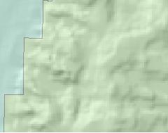
1 Natural Natural Quality applies to those features in the visual environment that are in a relatively undisturbed state. These features predate the arrival of human populations and may include geological formations, fossils, landform, water bodies, vegetation, and wildlife. There may be evidence of human activity, but the natural features reveal minimal disturbances. Natural intrinsic qualities abound along Utah s Patchwork Parkway. Such qualities include geological formations, paleontological phenomenon, vegetation and wildlife. Because the road passes through different ecosystems, vegetation and wildlife are quite diverse. Factors such as elevation, temperature, available moisture, soil makeup and slope direction effect plant distribution. Erosion has played a major role in exposing many geologic formations throughout the corridor. The crown jewel of these formations is Cedar Breaks National Monument, a 2,000 foot deep amphitheater Spectacular lava fields along SR143 provide the traveler with a sense of the awesome forces of nature that have shaped the terrain. (Photo by Five County Association of Governments) eroded from the Claron formation. The vegetation, wildlife and geology of the area become a living laboratory for those interested in natural and geologic aspects of the journey. For others it is simply a vivid display of color and natural sculpture that attracts their attention on this scenic drive. The Markagunt Plateau is important because the natural lakes, riparian areas and high mountain habitat provide for a wide variety of wildlife. More than 350 fish and wildlife species live on the plateau. Utah prairie dog, peregrine falcon, three-toed woodpecker, northern goshawk, sage grouse, and boreal toads are some species of special interest found along the Parkway. World-class hunting opportunities for mule deer, Rocky Mountain elk, pronghorn antelope and black bear abound. Crystal clear water flows in Mammoth Creek along SR143 in this late fall photograph. Soon snow will provide a white blanket covering this area as the season changes into winter. (Photo by Five County Association of Governments) 26 Utah s Patchwork Parkway SCENIC BYWAY CORRIDOR MANAGEMENT PLAN (SR 143)

2 Sixteen species of rare plants also exist on the plateau. Several plants grow only on habitats provided by unique rock formations. Some of the last remaining tall forb plant communities remaining in Utah are found on the plateau. Brian Head hosts an annual week-long Field Ecology course in June. Teachers use stateof-the-art equipment to learn various surveying techniques. They are also instructed how to take field notes, analyze data, and other research skills vital to strengthen secondary school science curriculums. The abundance and diversity of natural resources were vital to sustaining early Native American cultures, early explorers and Mormon settlers. These included unique silica deposits and timber as well as other natural resources. Strategies for Natural Qualities A. Encourage communities to adopt ordinances that help ensure maximum protection of nighttime skies. B. Develop sites and interpretive materials that highlight natural resources along the corridor. C. Cooperate with all agencies on long range planning. D. Cooperate in the efforts to develop a Cedar Mountain driving tour. Two adventurers contemplate activities they have planned for a sunny morning near Cedar Breaks. (Photo courtesy of Cedar City & Brian Head Tourism Bureau) Utah s Patchwork Parkway SCENIC BYWAY CORRIDOR MANAGEMENT PLAN (SR 143) 27
 near the junction of Utah s Patchwork Parkway and SR148.")
3 A young family enjoying a spectacular view at Cedar Breaks National Monument. A huge natural amphitheater has been eroded out of the variegated Pink Cliffs (Claron Formation) near the junction of Utah s Patchwork Parkway and SR148. Millions of years of sedimentation, uplift and erosion have created a deep canyon of rock walls, fins, spires and columns, that spans some three miles, and is over 2,000 feet deep. The rim of the canyon is over 10,000 feet above sea level, and is forested with islands of Englemann spruce, subalpine fir and aspen; separated by broad meadows of brilliant summertime wildflowers. (Photo courtesy of the Cedar City & Brian Head Tourism Bureau) 28 Utah s Patchwork Parkway SCENIC BYWAY CORRIDOR MANAGEMENT PLAN (SR 143)
 Utah s Patchwork Parkway SCENIC BYWAY")
4 The natural beauty found along Utah s Patchwork Parkway is second to none. (Photo courtesy of Cedar City & Brian Head Tourism Bureau) Utah s Patchwork Parkway SCENIC BYWAY CORRIDOR MANAGEMENT PLAN (SR 143) 29
5 Existing Natural Qualities # Resource Location N1 Sols Spring Parowan Canyon N2 Vermilion Castle First Left Hand Fork Canyon N3 Five Mile Campground First Left Hand Fork Canyon N4 Bear Caves Parowan Canyon N5 Sugarloaf Mountain West of Brian Head N6 Twisted Forest Ashdown Gorge N7 Top 10 Night Sky Site Cedar Breaks N8 Bristlecone Pine Cedar Breaks N9 Cedar Breaks Natl. Monument Cedar Breaks N10 Ashdown Gorge WA West of Cedar Breaks N11 Wildflowers/Fall Foliage Markagunt Plateau N12 Bark Beetle Infestation Markagunt Plateau spruce forests N13 Red Aspen Grove Castle Creek N14 Trophy Elk Markagunt Plateau N15 Mammoth Spring Mammoth Creek headwater N16 Lava Flow Panguitch Lake N17 Panguitch Lake Panguitch Lake N18 White Rocks South Canyon N19 Outdoor Classroom Panguitch 30 Utah s Patchwork Parkway SCENIC BYWAY CORRIDOR MANAGEMENT PLAN (SR 143)


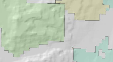
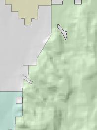
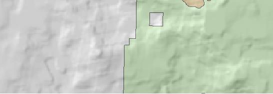
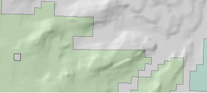
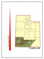
6 "Utah's Patchwork Parkway" State Route Corridor Management Plan Natural Qualities Map Paragonah C14 15 N4 N1 N2 N3 Brian Head Parowan N5 N6 N7N8 N9 N14 N12 N13 N11 N10 Cedar N15 Ashdown Gorge Wilderness Area Breaks National Monument C148 Panguitch Lake Miles N16 N17 Iron County Garfield County C143 N18 ( Natural Qualities Major Roads State Route 143 County Road State Route Interstate US Route Highway 143 Corridor N19 Legend tu 89 tu 89 Administration Panguitch Bureau of Land Management (BLM) National Park Service (NPS) Private State Trust Land State Wildlife Reserve/ Management Area US Forest Service (USFS) USFS Wilderness Area Water Town Boundaries Hatch Five County Association of GovernmentsFebruary 2008Curt Hutchings FCAOG GIS uses information and data from many different sources which may be of differing accuracy and which have been integrated to provide a planning context. These products should be used only for the purpose they were intended. For specific data source information, please contact FCAOG GIS. (435) chutchings@fcaog.state.ut.us C12
Bryce Canyon Country ATV Multi-Day Itinerary
 Bryce Canyon Country ATV Multi-Day Itinerary Look for more trail information and maps on these web-sites listed below. www. Casto Canyon Kick off your ATV adventure with this 36 mile round-trip ride through
Driving Time: 3 hours (allow extra time for stops)
") Scenic Byways loop This journey takes visitors through the eastern edge of Mt. Rainier National Park and along two of Washington s most beloved scenic byways, the Chinook Byway and the White Pass Scenic
Scenic Byways loop This journey takes visitors through the eastern edge of Mt. Rainier National Park and along two of Washington s most beloved scenic byways, the Chinook Byway and the White Pass Scenic
CAMP ROCK RANCH JACK KAVANAUGH RMABROKERS.COM
 CAMP ROCK RANCH JACK KAVANAUGH 303.909.1706 JACK@RMABROKERS.COM RMABROKERS.COM CAMP ROCK RANCH COLORADO - CLEAR CREEK COUNTY - UPPER BEAR CREEK ROAD, EVERGREEN The 162±-acre Camp Rock Ranch is surprisingly
2.0 PARK VISION AND ROLES
 2.0 PARK VISION AND ROLES 2.1 Significance in the Protected Area System Marble Range and Edge Hills provincial parks protect 6.8% of the Pavillion Ranges Ecosection, which is located in the Southern Interior
BryceCanyon Country. Destination Vacation Itinerary.
 BryceCanyon Country Destination Vacation Itinerary Thisisanitinerarythatoutlinesasix-dayvacationexperienceintheBryceCanyon Countryarea.Theitinerarybeginsonthewestandconcludesonthenorthwest endofscenicbyway12,butcanbeadjustedtosuitanytravelplans.
Outreach Notice. FREMONT-WINEMA NATIONAL FOREST Zone Planning Staff GS Winter Rim Zone Paisley and Silver Lake Ranger Districts
 Outreach Notice FREMONT-WINEMA NATIONAL FOREST Zone Planning Staff GS-0401-11 Winter Rim Zone Paisley and Silver Lake Ranger Districts The Position This position is located on the Winter Rim Zone, Fremont-Winema
ANGEL PEAK SCENIC AREA
 Activities: Facilities: ANGEL PEAK SCENIC AREA Hiking, photography, watchable wildlife, camping, picnicking. Note: While formal hiking trails in the area are limited, dispersed hiking opportunities abound
KANANASKIS COUNTRY PROVINCIAL RECREATION AREAS MANAGEMENT PLAN DRAFT TERMS OF REFERENCE - November 20, 2007
 KANANASKIS COUNTRY PROVINCIAL RECREATION AREAS MANAGEMENT PLAN DRAFT TERMS OF REFERENCE - November 20, 2007 BACKGROUND There are 42 Provincial Recreation Areas (PRAs) within Kananaskis Country located
B HALL RANCH FISHTAIL, MONTANA
 Brochure Courtesy of: B HALL RANCH FISHTAIL, MONTANA w w w. m c c a s l i n l a n d. c o m Page 1 LOCATION The Hall Ranch is ideally located in the foothills of the Beartooth Mountains, approximately 5
Evaluation of Outstanding Remarkable Values for Collawash River March 2011
 Evaluation of Outstanding Remarkable Values for Collawash River March 0 Segment From headwaters of East Fork Collawash River to Buckeye Creek Mileage: miles Free flowing: Yes Scenic:, Substantial River
Frazier Canyon Ranch 3,020 Acres Jeff Davis County, Texas
 Frazier Canyon Ranch 3,020 Acres Jeff Davis County, Texas James King, Agent Office 432 426.2024 Cell 432 386.2821 James@KingLandWater.com Frazier Canyon Ranch 3,020 acres Jeff Davis County, Texas James
HIGH COUNTRY L-BAR RANCH
 HIGH COUNTRY L-BAR RANCH Sandoval and mckinley counties N e w m e x i c o Jim Haworth, Ranch Team Lead Broker ~ 505-235-5236 3613 NMSR 528 NW, Ste. H, Albuquerque, NM 87114 505-792-3713 www.wwrealty.com
Idaho Native Plant Society 2018 Annual Meeting
 Idaho Native Plant Society 2018 Annual Meeting Hosted by: Calypso Chapter, Idaho Native Plant Society, Coeur d Alene, Idaho Dates: Friday thru Monday, June 29 thru July 2, 2018 Meeting Location: US Forest
BRYCE CANYON COUNTRY Boulder Mountain Scenic backways itinerary
 BRYCE CANYON COUNTRY Boulder Mountain Scenic backways itinerary Boulder Mountain Area The high plateaus of the Aquarius Plateau (Boulder Mountain), are heavily forested and covered in countless winding
Comanche National Grassland, Timpas Unit
 Comanche National Grassland, Timpas Unit Heritage Resources More than 540 sites are eligible for listing on the National Register of Historic Places (NRHP) by Forest Service staff and/or the Colorado State
FINGER-TATUK PROVINCIAL PARK
 FINGER-TATUK PROVINCIAL PARK PURPOSE STATEMENT AND ZONING PLAN March 2003 FINGER-TATUK PROVINCIAL PARK Purpose Statement and Zoning Plan Finger-Tatuk Provincial Park is 17,151 ha in size. It includes the
Connie Rudd Superintendent, Black Canyon of the Gunnison National Park
 National Park Service U.S. Department of the Interior Black Canyon of the Gunnison National Park and Curecanti National Recreation Area Information Brochure #1 Wilderness and Backcountry Management Plan
HUNTING PROPERTIES Bearpaw Trail Hand constructed with reclaimed timbers from a historic Stagestop.
 $4,500,000 #139289 428.0 AC $2,500,000 #138964 113.5 AC $24,9500,000 #137591 9,000.0 AC 8855 Bearpaw Trail Includes a 3 acre lake and borders Routt National Forest. 8925 Bearpaw Trail Hand constructed
Brinker Creek Ranch. Colorado - Routt County - Yampa
 Located at the base of the Flattops Range in the Steamboat/Vail corridor, Brinker Creek Ranch consists of 1,451 acres ideally suited for high country grazing and native grass hay production. Traditionally
St. George Jeepers Torrey, Utah, Fall Foliage Outing September 26, 2016
 St. George Jeepers Torrey, Utah, Fall Foliage Outing September 26, 2016 On a beautiful, sunny fall day fourteen vehicles departed the Maverick station in Cedar City for a ride to Torrey, Utah. We were
Role of the Protected Area
 Role of the Protected Area Provincial and Regional Context Height of the Rockies and Elk Lakes provincial parks lie in southeastern British Columbia in the Rocky Mountains, about 85 km southwest of Calgary,
OMINEACA PROVINCIAL PARK
 OMINEACA PROVINCIAL PARK AND PROTECTED AREA PURPOSE STATEMENT AND ZONING PLAN March 2003 OMINECA PROVINCIAL PARK AND PROTECTED AREA Purpose Statement and Zoning Plan Omineca Park and Omineca Protected
USDA FOREST SERVICE INTERMOUNTAIN REGION, R4 Forestry Technician Timber Sale Admin GS /9/10. Dixie National Forest
 USDA FOREST SERVICE INTERMOUNTAIN REGION, R4 Forestry Technician Timber Sale Admin GS-0462-8/9/10 Dixie National Forest Cedar City Ranger District Escalante Ranger District 1789 N Wedgewood Lane 755 W
1 Permanent Full Time Forester GS /07/09 Kaibab National Forest Duty Station: Williams or Tusayan, AZ
 1 Permanent Full Time Forester GS-460-05/07/09 Kaibab National Forest Duty Station: Williams or Tusayan, AZ Merit Vacancy Announcement: Open Monday January 11 th to Friday January 20 th 2016 and working
The following criteria were used to identify Benchmark Areas:
 7.0 BENCHMARK AREAS The Churn Creek Protected Area offers a significant opportunity to learn more about how grassland ecosystems function. One of the key tools that will be used to monitor larger grassland
BIGHORN BACKCOUNTRY ACCESS MANAGEMENT PLAN
 BIGHORN BACKCOUNTRY ACCESS MANAGEMENT PLAN October, 2002 SPECTACULAR BY NATURE BIGHORN BACKCOUNTRY Alberta s Bighorn Backcountry offers spectacular Rocky Mountain scenery and unforgettable recreational
Washakie Wilderness Ranch
 Washakie Wilderness Ranch Dubois, Wyoming Fly Fishing Hunting Ranching Conservation Washakie Wilderness Ranch Dubois, Wyoming Introduction: A stunning 160-acre parcel located at the base of the Ramshorn
Internet TripTik. From : Zion National Park, Ut Stop At Stop At Stop At Stop At Stop At. : Bryce Canyon National Park, Ut : Arches National Park, Ut
 MAP: Overview Internet TripTik From : Zion National Stop At Stop At Stop At Stop At Stop At To : Bryce Canyon National Park, Ut : Arches National : Canyonlands National : Monument Valley, Utah : Kayenta,
Weston County, Wyoming
 The Sweet 200-Acre Property Weston County, Wyoming A unique opportunity to own a little piece of the old West, where one can experience unparalleled scenery, adventure and history walk in the footsteps
Fraser River Provincial Park Purpose Statement and Zoning Plan
 Fraser River Provincial Park Purpose Statement and Zoning Plan Fraser River Provincial Park is located on the west bank of the Fraser River, approximately 35 km south of Prince George. This 4,899 ha Protected
Hartsel Springs Ranch 4,637 Acres Park County, Colorado $4,780,000
 Hartsel Springs Ranch 4,637 Acres Park County, Colorado $4,780,000 Presented By: Farm, Ranch & Recreational Real Estate Hartsel Springs Ranch 4,637 Acres Park County, Colorado $4,780,000 Property Description
U.S. Bicycle Route System Routes 70 and 79 Utah's Redrock Bikeway
 U.S. Bicycle Route System Routes 70 and 79 Utah's Redrock Bikeway Page Index Map Symbols US Bicycle Route City Interstate US Highway State Highway Major Local Road, Paved Major Local Road, Not Paved Railroad
Morgan Estates. Lassen County, CA. Proudly Offered By
 Morgan Estates Lassen County, CA Proudly Offered By 707 Merchant Street, Suite 100, Vacaville, Ca 95688 (707) 455-4444 Office (707) 455-0455 Fax info@caoutdoorproperties.com Introduction Looking North
APPENDIX C WILDERNESS EVALUATION
 APPENDIX C WILDERNESS EVALUATION Introduction This appendix describes the process used to inventory and evaluate areas on the Wasatch Cache National Forest for their potential as wilderness. Each of the
Fred Antoine Park. Management Plan. Final Public Review Draft
 Fred Antoine Park Management Plan Final Public Review Draft March 2016 Fred Antoine Park Management Plan Approved by: Jeff Leahy Regional Director Thompson Cariboo Region BC Parks Date Brian Bawtinheimer
BUCK POINT RANCH. Aspen Associates Realty
 BUCK POINT RANCH Aspen Associates Realty www.aspenassociatesrealty.com 970.544.5800 WELCOME TO Buck Point Ranch is a 960± acre property located in one of the last pristine valleys in close proximity to
April 10, Mark Stiles San Juan Public Lands Center Manager 15 Burnett Court Durango, CO Dear Mark,
 Mark Stiles San Juan Public Lands Center Manager 15 Burnett Court Durango, CO 81301 Dear Mark, We are pleased to offer the following comments on the draft San Juan Public Lands Center management plans
TAKE YOUR TIME STAKEHOLDERS GUIDE
 TAKE YOUR TIME STAKEHOLDERS GUIDE 2015 Best Ad Campaign WINNER Our award-winning TAKE YOUR TIME ad campaign has brought incredible success to the community. The campaign features TV spots, print ads and
MANAGEMENT DIRECTION STATEMENT June, 1999
 Thompson River District MANAGEMENT DIRECTION STATEMENT June, 1999 for Clearwater River Corridor (Addition to Wells Gray Park) Ministry of Environment Lands and Parks BC Parks Division ii Table of Contents
You can learn more about the trail camera project and help identify animals at WildCam Gorongosa (
 INTRODUCTION Gorongosa National Park is a 1,570-square-mile protected area in Mozambique. After several decades of war devastated Gorongosa s wildlife populations, park scientists and conservation managers
COLORADO TRAIN ADVENTURE
 COLORADO TRAIN ADVENTURE by Melody Hagerman at Travel the Horizon Summary Traveling by rail in Colorado is the most spectacular way to take in its unique scenery. From high above the tracks, you'll enjoy
2nd Edition Consignment Store 348 Main Street, Delta, Colorado For Sale or Lease
 2nd Edition Consignment Store 348 Main Street, Delta, Colorado For Sale or Lease Longtime Established Consignment Clothing and Accessories Store Located in the Heart of the City of Delta Known for it s
BRYCE CANYON COUNTRY. A twisted tree endures rugged life on the rim of the Paunsaugunt Plateau.
 BRYCE CANYON COUNTRY Grand Staircase - Paunsaugunt Plateau Scenic backways itinerary A twisted tree endures rugged life on the rim of the Paunsaugunt Plateau. Travel to Bryce Canyon Country. Lodging check-in,
Bryce Canyon Country.
 Bryce Canyon Country Backways Itinerary - Grand Staircase, Capitol Reef Region Grand Staircase/Capitol Reef/Henry Mountains Adventure off the beaten path and revel in the beauty of Utah s scenic backways.
Bat Cave Canyon Ranch 2,920 acres Jeff Davis County, Texas
 Bat Cave Canyon Ranch 2,920 acres Jeff Davis County, Texas James King, Agent Office 432.426.2024 Cell 432.386.2821 James@KingLandWater.com Bat Cave Canyon Ranch 2,920 acres Jeff Davis County, Texas James
Colorado Life Zone Scavenger Hunt
 Colorado Life Zone Scavenger Hunt Below are worksheets created for all the habitats or life zones. They were designed with the intention of breaking the class up into small groups, and having students
Ortiz River Ranch Pagosa Springs, Colorado
 Ortiz River Ranch Pagosa Springs, Colorado This ranch provides an exceptional opportunity to own a property with frontage on the San Juan and Navajo Rivers, lush irrigated pastures, and beautiful rolling
Rogue Gorge (Mt. Stella) Roadless Area-- T30S R3E (primarily in portions of Sections 23, 26, 33, 34 & 35)
 Roadless Area-- T30S R3E (primarily in portions of Sections 23, 26, 33, 34 & 35)") Rogue Gorge (Mt. Stella) Roadless Area-- T30S R3E (primarily in portions of Sections 23, 26, 33, 34 & 35) Rogue River-Siskiyou National Forest--High Cascades Ranger District Upper, higher elevation trail
Rogue Gorge (Mt. Stella) Roadless Area-- T30S R3E (primarily in portions of Sections 23, 26, 33, 34 & 35) Rogue River-Siskiyou National Forest--High Cascades Ranger District Upper, higher elevation trail
Logan Canyon Hiking Trail Guide
 C a c h e V a l l e y V i s i t o r s B u r e a u Logan Canyon Hiking Trail Guide Monique Beeley Legend Trail Location Guide WASATCH CACHE NATIONAL FOREST WILDERNESS PAVED WATER TRAILHEAD 9 Logan River
discover Genuine Montana The Last Best Place Great Falls Montana
 discover Genuine Montana The Last Best Place Great Falls Montana the grandest sight I ever beheld... 1805 Meriwether Lewis journal entry Resting on the high plains along Montana s Rocky Mountain Front
Kwadacha Wilderness Provincial Park and Kwadacha Addition (Kwadacha Recreation Area) Purpose Statement and Zoning Plan
 Purpose Statement and Zoning Plan") Kwadacha Wilderness Provincial Park and Kwadacha Addition (Kwadacha Recreation Area) Purpose Statement and Zoning Plan Located in a remote area of the northern interior of BC, this large park straddles
Kwadacha Wilderness Provincial Park and Kwadacha Addition (Kwadacha Recreation Area) Purpose Statement and Zoning Plan Located in a remote area of the northern interior of BC, this large park straddles
Ranch. Creek. Cow. Mountain
 Cow Creek Mountain Ranch Situated along the southwestern hills of the Laramie Mountains and the Medicine Bow-Routt National Forest in northeastern Albany County, Wyoming. 58 E. Benteen Street Buffalo,
PAD-US 1.1 (CBI Edition) Management Designations. National Parks (NPS) and National Park
 Management Designations. National Parks (NPS) and National Park") Noise Sensitive Areas Avoidance Criteria & Source PAD-US 1.1 (CBI Edition) Management Designations Falcon View "DESGINATE" Field Terminology Falcon View Display Category Boundary Waters Canoe Wilderness
Noise Sensitive Areas Avoidance Criteria & Source PAD-US 1.1 (CBI Edition) Management Designations Falcon View "DESGINATE" Field Terminology Falcon View Display Category Boundary Waters Canoe Wilderness
(Short Listing) DUPUYER ACREAGE, ROCKY MOUNTAN FRONT
 DUPUYER ACREAGE, ROCKY MOUNTAN FRONT") (Short Listing) DUPUYER ACREAGE, ROCKY MOUNTAN FRONT This unique property is located 8½ miles northwest of Dupuyer, Montana and approximately thirty 30 miles northwest of Choteau, Montana. Great Falls
(Short Listing) DUPUYER ACREAGE, ROCKY MOUNTAN FRONT This unique property is located 8½ miles northwest of Dupuyer, Montana and approximately thirty 30 miles northwest of Choteau, Montana. Great Falls
Southern Utah University Hike Brochure
 Southern Utah University Hike Brochure Taylor Creek Trail Twenty minutes from Cedar City Red Hollow An hour and a half from Cedar City Fees: Entrance fee to Kolb Canyon Length: 5 miles round trip Length:
Presidential Documents
 Federal Register Vol. 65, No. 80 Tuesday, April 25, 2000 Presidential Documents 24095 Title 3 The President Proclamation 7295 of April 15, 2000 Establishment of the Giant Sequoia National Monument By the
Appendix A BC Provincial Parks System Goals
 Appendix A BC Provincial Parks System Goals The British Columbia Provincial Parks System has two mandates: To conserve significant and representative natural and cultural resources To provide a wide variety
Sunrise Ranch 6890 acres, Jeff Davis County, Texas On the Fort Davis Scenic Loop
 Sunrise Ranch 6890 acres, Jeff Davis County, Texas On the Fort Davis Scenic Loop 432-386-2821 Cell 432-426-2024 Office james@kinglandwater.com King Land & Water LLC P.O. Box 109, 600 State Street, Fort
2.1 Physical and Biological Description Matabitchuan River Watershed
 2.1 Physical and Biological Description Watershed 2.1.1 Physical Description The system watershed has a total area of about 933 km 2 and is a tributary system to Lake Temiskaming and the Ottawa River Drainage
Yellowstone & Jackson Hole Six Day Tour
 Yellowstone & Jackson Hole Six Day Tour Trip Highlights: Wildlife: Eagles, Bears & Bison! Active Volcanoes Colorful Lakes & Mudpots Rafting or Floating Exploring the 1st National Park in the USA Fishing
Mackinnon Esker Ecological Reserve Draft - Management Plan
 Mackinnon Esker Ecological Reserve Draft - Management Plan May 2011 Photo Credit: This document replaces the direction provided in the Carp Lake Provincial Park and Protected Area and Mackinnon Esker Ecological
2019 Work Week Crew. Schedule and Descriptions
 2019 Work Week Crew WAWONA WW1 Mariposa Grove Restoration and Invasive Plant Removal June 2 June 8 YOSEMITE VALLEY YV1 Washington Column Climber s Trail Rehabilitation June 9 June 15 YV2 Weed Warriors/
Mazatzal Wilderness Trail Maintenance and Exploration
 Mazatzal Wilderness Trail Maintenance and Exploration March 15-19 (Wednesday - Sunday) Difficulty: Beginner Camping: Car Camping Mileage: Wednesday ~4 miles Thursday ~4-6 miles Friday ~4-6 miles Saturday
APPENDIX. Alberta Land Stewardship Act AMENDMENTS TO THE SOUTH SASKATCHEWAN REGIONAL PLAN
 APPENDIX Alberta Land Stewardship Act AMENDMENTS TO THE SOUTH SASKATCHEWAN REGIONAL PLAN 1 All references to Alberta Environment and Sustainable Resource Development, Environment and Sustainable Resource
BLANKET CREEK PROVINCIAL PARK
 BLANKET CREEK PROVINCIAL PARK PURPOSE STATEMENT AND ZONING PLAN February 2003 BLANKET CREEK PROVINCIAL PARK Purpose Statement and Zoning Plan Primary Role The primary role of Blanket Creek Park is to maintain
Region 1 Piney Woods
 Region 1 Piney Woods Piney Woods 1. This ecoregion is found in East Texas. 2. Climate: average annual rainfall of 36 to 50 inches is fairly uniformly distributed throughout the year, and humidity and temperatures
Special Recreation Management Areas Extensive Recreation Management Areas Public Lands Not Designated as Recreation Management Areas
 From the Proposed RMP: Special Recreation Management Areas SRMAs are an administrative unit where the existing or proposed recreation opportunities and recreation setting characteristics are recognized
Subject to sale, withdrawal, or error.
 The Crawford L Bar Ranch is located approximately 40 air miles west of Albuquerque, New Mexico. This ranch truly epitomizes the description of New Mexico being the Land of Enchantment. The topography and
Maya s Creek Crossing Hwy 17 N acres $185,000 Fort Davis, Texas
 Maya s Creek Crossing Hwy 17 N 14.98 acres $185,000 Fort Davis, Texas James King, Agent Office 432-426-2024 Cell 432-386-2821 James@KingLandWater.com King Land & Water LLC P.O. Box 109, 600 State Street,
Marchand Provincial Park. Management Plan
 Marchand Provincial Park Management Plan 2 Marchand Provincial Park Table of Contents 1. Introduction... 3 2. Park History... 3 3. Park Attributes... 4 3.1 Natural... 4 3.2 Recreational... 4 3.3 Additional
PAUL S PLACE ELK, DEER AND VIEWS FISHTAIL, MONTANA
 McCaslin Land 2010 PAUL S PLACE ELK, DEER AND VIEWS FISHTAIL, MONTANA LOCATION Paul s Place is ideally located in the foothills of the Beartooth Mountains, approximately 5 to 5-1/2 miles west of Fishtail,
ANAGEMENT P LAN. February, for Elk Lakes and Height of the Rockies Provincial Parks. Ministry of Environment, Lands and Parks BC Parks Division
 M ANAGEMENT P LAN February, 1999 for Elk Lakes and Height of the Rockies Provincial Parks Ministry of Environment, Lands and Parks BC Parks Division Elk Lakes & Height of the Rockies Provincial Parks M
230 East Bridge Street Hotchkiss, Colorado 81419
 230 East Bridge Street Hotchkiss, Colorado 81419 Located in the center of downtown Hotchkiss, close to the schools, the Delta County Fairgrounds and Town Hall. This is an ideal set up for an owner/ entrepreneur.
Pinawa Provincial Park. Draft Management Plan
 Pinawa Provincial Park Draft Management Plan Pinawa Provincial Park Draft Management Plan Table of Contents 1. Introduction... 3 2. Park History... 3 3. Park Attributes... 4 3.1 Natural... 4 3.2 Recreational...
The Geological Pacific Northwest. Wednesday February 6, 2012 Pacific Northwest History Mr. Rice
 The Geological Pacific Northwest Wednesday February 6, 2012 Pacific Northwest History Mr. Rice 1 Free Response #2 Please do not simply list the items for this response. Full sentences!!! Minimum of 3-5
Program Itinerary. Teton Science School Jackson Campus is nestled on a 900-acre site filled with creeks, ponds, and aspen, conifer and sage habitats.
 Dear CTY families, We are delighted to invite you on a journey to the northwest corner of Wyoming, one of our nation's most spectacular natural regions. Planned in collaboration with Teton Science Schools,
BUTCHER CREEK RANCH. Butcher Creek Ranch. Roscoe, Montana. Reduced to $1,650,000.
 BUTCHER CREEK RANCH Butcher Creek Ranch Roscoe, Montana Reduced to $1,650,000. Offered Exclusively By: Sonny Todd Real Estate 301 West First Avenue, PO Box 788 Big Timber, Montana 59011 Office: (406) 932-1031
Brian Head Singletrack
 DAY 1 After meeting up in St. Geroge, we will shuttle up to the high country to access extraordinary singletrack! After fueling up with a hearty lunch, we ride to the Thunder Mountain Trailhead where the
List Price: $1,100,000 Includes Real Estate, Business and FF&E
 Tayshen Automotive 105 1/2 Eaton Ave Delta, Colorado 81416 This high end/state of the art automotive full service shop is the envy of all competitors, highly successful, with dedicated, well trained staff,
543 MAIN STREET DELTA, COLORADO HISTORIC DOWNTOWN BUILDING
 543 MAI STREET DELTA, COLORADO HISTORIC DOWTOW BUILDIG PROPERTY FEATURES Spanish style building with great store front Private office, large office/work area/ restroom and breakroom Large shop area with
GIFFORD PINCHOT NATIONAL FOREST
 GIFFORD PINCHOT NATIONAL FOREST 9341 Wright Meadow 93 Spencer Meadow Spencer Butte 4247' 30 30A 19 24 80 31C Lewis River Lower Falls 5 Quartz Creek 90 Taidnapam Falls Upper Falls 31 Spencer Peak 3861'
Frizzell Creek Ranch Summerville, OR $1,400, ± Acres
 Frizzell Creek Ranch Summerville, OR $1,400,000 165± Acres 1 Introduction The Frizzell Creek Ranch is a beautiful 165± acre ranch located in northeast Oregon at the base of the Wallowa Whitman National
Physical Regions of the U.S.
 Physical Regions of the U.S. Quickly use this map to label the map on your paper Pacific Coast The coast from southern California to Alaska The region of the Pacific Northwest has a long history that was
2018 SEASONAL POSITION OUTREACH NOTICE
 Bridger-Teton National Forest 2018 SEASONAL POSITION OUTREACH NOTICE The Bridger Teton National Forest may fill up to 99 positions, including: recreation (trails, wilderness, off highway vehicle, river),
Seager Wheeler Lake. Representative Area. -- Concept Management Plan --
 Seager Wheeler Lake Representative Area -- Concept Management Plan -- Saskatchewan Environment and Resource Management January, 1999 Saskatchewan s Representative Areas Network Program The Government of
Daisy Dean Creek Ranch
 Daisy Dean Creek Ranch MARTINSDALE, MONTANA Hunting Ranching Fly Fishing Conservation Daisy Dean Creek Ranch MARTINSDALE, MONTANA Introduction: Daisy Dean Creek Ranch is comprised of 1,652 acres with a
List Price: $1,100,000 PRICED DROPPED TO $950,000!! Includes Real Estate, Business and FF&E
 Tayshen Automotive 105 1/2 Eaton Ave Delta, Colorado 81416 This high end/state of the art automotive full service shop is the envy of all competitors, highly successful, with dedicated, well trained staff,
TOWER-ROOSEVELT AREA MAP
 TOWER-ROOSEVELT AREA MAP Page 1 of 14 Tower-Roosevelt to Canyon Road Map Yellowstone Tower-Roosevelt Area Page 2 of 14 Tower-Roosevelt to Mammoth Road Map Page 3 of 14 Tower-Roosevelt to the Northeast
Hiking Trail Descriptions
 Hiking Trail Descriptions For ye shall go out with joy. And be led forth with peace. The mountains and the hills shall break forth before you in singing. And all the trees of the fields shall clap their
Blanco Creek Ranch Acres, Uvalde County, Texas
 Blanco Creek Ranch 1208.30 Acres, Uvalde County, Texas James King, Agent Office 432 426.2024 Cell 432 386.2821 James@KingLandWater.com Blanco Creek Ranch 1208.30 acres Uvalde County, Texas James King,
Utah Bryce Canyon & Zion
 Trip Summary Southwestern Utah s National Parks are two of the most geologically fascinating and stunningly beautiful places on earth. Explore rim country with a hike to Angel s Landing, 1,200 feet above
Whitemouth Falls Provincial Park. Draft Management Plan
 Whitemouth Falls Provincial Park Draft Management Plan Whitemouth Falls Provincial Park Draft Management Plan Table of Contents 1. Introduction... 3 2. Park History... 3 3. Park Attributes... 4 3.1 Natural...
Stuart River Provincial Park Purpose Statement and Zoning Plan
 Stuart River Provincial Park Purpose Statement and Zoning Plan Stuart River Provincial Park protects three-quarters of the 110 kilometer long Stuart River corridor between Stuart Lake and the Nechako River.
5.0 OUTDOOR RECREATION OPPORTUNITIES AND MANAGEMENT
 5.0 OUTDOOR RECREATION OPPORTUNITIES AND MANAGEMENT 5.1 Introduction This section describes the range of recreational activities that currently take place in Marble Range and Edge Hills Parks, as well
CONSERVATION PLAN FOR THE CARTER PROPERTY BEAR LAKE COUNTY, IDAHO
 CONSERVATION PLAN FOR THE CARTER PROPERTY BEAR LAKE COUNTY, IDAHO Prepared By John Carter P.O. Box 280 Mendon, Utah 84325 435-881-1232 IINTRODUCTION In 1993, I began acquiring land in Paris Canyon, Idaho
Non-motorized Trail Plan & Proposal. August 8, 2014
 Town of Star Valley Ranch, Wyoming and the Star Valley Ranch Association in partnership with the USDA Forest Service, Bridger-Teton National Forest, Greys River Ranger District Non-motorized Trail Plan
What Is An Ecoregion?
 Ecoregions of Texas What Is An Ecoregion? Ecoregion a major ecosystem with distinctive geography, characteristic plants and animals, and ecosystems that receives uniform solar radiation and moisture Sometimes
life is good vacations
 i life is good vacations UTAH BRYCE CANYON & ZION Join us on a one-of-a-kind journey to share the beauty of the outdoors and the beauty that lies within. Guided by our team of experts, you and your guests
White Mountain Wilderness Trails
 The area in which these hikes are located is rugged high mountain country along the Mogollon Rim. This famous eastwest escarpment separates Arizona's high plateau from the basin and range below. These
Map 1.1 Wenatchee Watershed Land Ownership
 Map 1.1 Wenatchee Watershed Land Ownership Map 1.1 Wenatchee Watershed Land Ownership The Wenatchee watershed lies in the heart of Washington state in Chelan County. Just larger than the state of Rhode