FILLONGLEY, TRIBUNE BAY, HELLIWELL, SANDY ISLAND PARKS MASTER PLAN
|
|
|
- Vivian Bailey
- 5 years ago
- Views:
Transcription
1 FILLONGLEY, TRIBUNE BAY, HELLIWELL, SANDY ISLAND PARKS MASTER PLAN Province of Ministry of British Columbia Environment and Parks September 1987
2 Mr. H. V. Collins Assistant Deputy Minister Parks and Outdoor Recreation Division This Master Plan for Fillongley, Helliwell, Tribune Ray and Sandy Island Provincial Parks is recommended for your approval. RECOMMENDED: Date: 87/04/30 R. J. Lampard District Manager Strathcona District Date: 87/05/05 G. Trachuk Regional Director South Coast Region APPROVED: Date: 87/12/01 M. V. Collins Assistant Deputy Minister
3 A MASTER PLAN FOR FILLONGLEY, TRIBUNE BAY, HELLIWELL, AND SANDY ISLAND PROVINCIAL PARKS SEPTEMBER, 1987
4 (i) TABLE OF CONTENTS Page I. Plan Summary 1 I. Background Report Summary 3 A. Location and Climate 3 B. Park Origins 3 C. Park Resources 4 I. Regional and Provincial Context 9 V. Fillongley Park A. Role of the Park 11 B. Zoning 11 C. Resource Management 13 D. Visitor Services 16 E. Plan implementation 18 V. Tribune Bay Park A. Role of the Park 19 B. Zoning 19 C. Resource Management 21 D. Visitor Services 24 E. Plan Implementation 26 I. Helliwell Park A. Role of the Park 28 B. Zoning 28 C. Resource Management 28 D. Visitor Services 31 E. Plan Implementation 33 I. Sandy Island Park A. Role of the Park 34 B. Zoning 34 C. Resource Management 34 D. Visitor Services 37 E. Plan Implementation 38 APPENDICES: Appendix 1: Background Report 40 Appendix 2: Outdoor Recreation Features Analysis 41
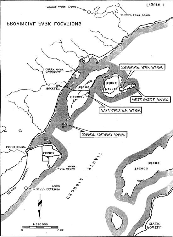
5 (ii) List of Figures Page Figure No. 1. Provincial Park Locations 2 2. Hornby Island Marine Park Proposal Location Fillongley Park Zoning and Development Fillongley Park Proposed Addition Tribune Bay Park Zoning Hornby Island Marine Park Proposal Helliwell Park Zoning Sandy Island Park Proposed Addition 35 List of Plates Plate No. 1. View north along Fillongley Creek 4 2. View east of Tribune Bay Park Beach 5 3. Rock cliffs and natural grass areas of Helliwell Park s south shore 6 4. East coast of Helliwell Park contains attractive pocket beaches 7 5. View north of the islands which make up Sandy Island Park 8
6 1 I. PLAN SUMMARY This document gives broad, long term direction to the management of the four provincial parks located on Denman and Hornby Islands (Figure 1). Comprising a typical Gulf Island environment and linked to Vancouver Island by ferry, the islands are well visited by non-residents during the summer months. Residents of the islands have a strong sense of community identity and highly valve their islands environment and atmosphere. The four relatively small provincial parks are cherished by both local residents and visitors, particularly as natural areas. While each park has its own specific features, they also share important common characteristics and management needs. Highlights of this master plan include the following: recognition of strong local interest in maintaining these parks at low levels of development. reconstruction of Fillongley Provincial Park campground and day use facilities to provide a more functional and aesthetic environment. the addition of the Fillongley Creek spit accretion to the park. the addition of foreshore to Sandy Island and Fillongley Parks to achieve protection of valuable marine resources and the presentation of increased recreation opportunities. conducting a park study of a marine park extending from Helliwell Park west to Savoie Rocks. emphasis at Fillongley and Tribune Bay parks on expanding the recreational opportunities for bicyclists and organized groups by providing formal walk-in camping areas. emphasis on a visitor services information program which informs the public about the resources and opportunities of the parks as well as such limiting factors as use capacity restrictions and specific requirements for resource protection.
7
8 II. BACKGROUND REPORT SUMMARY 3 The following information is summarized from the "Background Report", attached to this plan as Appendix I. A. Location and Climate Denman and Hornby Islands are situated close to the relatively sheltered central east coast of Vancouver Island, approximately halfway along Georgia Strait. The nearest urban areas on Vancouver Island are Courtenay-Comox (about 20 km north) and Nanaimo (about 80 km south). Denman Island is linked to Vancouver Island by a small ferry (10-15 minutes to cross). A similar ferry service connects Denman with Hornby Island. The climate, on the whole, is moist with the majority of the cm of precipitation falling between September and June, leaving the summer months quite dry normally. Summer temperatures are pleasantly warm, being moderated by cool sea breezes, while average winter temperatures are above freezing. In general it is a typical temperate maritime climate, with somewhat drier than normal summers. B. Park Origins Three of the parks Fillongley, Helliwell and Tribune Bay were previously privatelyowned properties. Fillongley Park on Denman Island was established in 1954, following donation from Mr. Beadnell who resided and is now buried on the property. The land comprising Helliwell Park on Hornby Island was donated by Mr. Helliwell and subsequently established as a park in Tribune Bay Park was jointly purchased by the Devonian Foundation and the Provincial Government, and was established in Sandy Island park was under Federal jurisdiction until its transfer to the province in 1966 when the area was designated a provincial park.
9 4 C. Park Resources 1. Fillongley Park Fillongley contains 23 hectares of gently sloping upland, adjoined by a 21 hectare foreshore recreation reserve. Fillongley Creek meanders through the park, forming a slough between a foreshore sandy spit and the eastern boundary of the park. Except for the clearing where the Beadnell residence once stood, the park features a mixed stand of mature coastal Douglas fir, Western red cedar, Western hemlock, and Broadleaf maple. This forest is highly significant because the park is one of the last unlogged areas on Denman Island. Principle attractions of the park are the sand spit, the undisturbed forest and the grounds of the former residence. The important planning issues involving Fillongley Park include the type and location of recreation site improvements within the park and the fact the sand spit and the attractive foreshore recreation reserve are not part of the park. PHOTO NOT AVAILABLE Plate 1 View North along Fillongley Creek. Sand spit on right of photograph.
10 5 2. Tribune Bay Park This park covers 96 hectares, of which 23 are foreshore over a broad, crescent-shaped sand beach and 73 are gently sloping up)and. The vegetation consists of about 70% forest cover, and about 30% grassland resulting from former cultivation (directly behind the beach). The forest is a second-growth mixture of coastal Douglas fir, Western red cedar, Grand fir, Western hemlock, and Broadleaf maple. Surface water, other than Tribune Bay itself, is limited to a small pond in the forest and an intermittent stream on the south edge of the grassland, near the shore. The former lodge and related buildings and facilities, including a picnic shelter and tennis courts, are located on the eastern side of the park. The major attraction of this park is the broad white sand beach, one of the outstanding sand beaches on the east coast of Vancouver Island, providing excellent family bathing and viewing recreation opportunities. Other attractions of the park include the open grasslands behind the beach and the shallow, relatively warm waters of Tribune Bay. The key planning issues for this park include questions on the provision of recreation facilities particularly for overnight use, use of the Lodge facilities end the future of the tennis courts in the park. PHOTO NOT AVAILABLE Plate 2 View East of Tribune Bay Park Beach
11 6 3. Helliwell Park The park contains 69 hectares of upland. The area is gently rolling and heavily forested with Coastal Douglas fir, Western hemlock, Arbutus, Garry oak, Lodgepole pine and Grand fir. Some very large examples of mature Douglas fir and Arbutus are found in the eastern portion of the park. Near the shore, the forest gives way to attractive grasslands. Other than temporarily during the wetter seasons, there is a shortage of surface water. PHOTO NOT AVAILABLE Plate 3 Rock cliffs and Natural grass areas of Helliwell Park s south shore. Major attractions of the park include: a) an interesting irregular shoreline sloping away into clear, unpolluted waters.
12 7 b) sea cliffs along the south shore. The cliffs are composed of conglomerate rock and occasional sandstone sills. These cliffs are of high significance as a recreation feature because of their size, height, colour and visual interest. c) natural grasslands of high quality, visual interest and excellent recreation values. The grasslands afford exceptional views across the cliffs out to Georgia Strait and Vancouver Island. d) a provincially significant undisturbed forest ecosystem where significant examples of Douglas fir and Arbutus are found. The key planning issues for this park include the addition of foreshore and two islets to the park, fire protection and establishing the appropriate park development and use. PHOTO NOT AVAILABLE Plate 4 The east coast of Helliwell Park contains attractive pocket beaches.
13 8 4. Sandy Island Park Located off the north end of Denman Island, Sandy Island Park comprises four small islands totaling 33 hectares. Sandy Island and Seal Islets are the portions of White Spit which remain above the high tide mark. The park thus contains specialized plants noted for their ability to survive in dry, exposed conditions. There is no forest cover except for a small area of low tree cover on Sandy Island. The major attractions of this park include the high quality sand beaches, eolian landforms, special plant communities and wildlife diversity. The addition of an extensive foreshore area (White Spit) is the chief planning issue. PHOTO NOT AVAILABLE Plate 5 View north of the islands which make up Sandy Beach Park.
14 9 III. Regional and Provincial Context Denman and Hornby Islands differ little from the more southerly Gulf Islands of Georgia Strait. Because of their scenic and rural nature some people have chosen to settle and live year-round on these pleasant islands while others have established summer cottages. The four provincial parks serve both island residents and visitors by conserving scenic natural areas and providing opportunities for outdoor recreation. These provincial parks are set aside for the enjoyment of all British Columbians and visitors to this province. On these particular islands, owing to the small amount of parkland and the high recreational demand, it is especially important to ensure that these four small parks continue to provide park opportunities for shoreline recreation, natural woodlands for walking and substantially undeveloped scenic areas for nature appreciation. In recent years local groups and individuals have expressed concern about the future of underwater resources and opportunities fronting the southerly coast of Hornby Island with many citizens advocating some form of protective status (figure 2). The study of a Provincial marine park is suggested for an area extending from Savoie Rocks to He1liwell Park and including lands and waters from the low tide mark to the 50 meter depth.
15
16 11 IV. Fillongley Park A. Role of the Park The conservation role for Fillongley Park is to protect and present high quality woodland and shoreline resources which represent the typical and special natural elements of Denman Island. The recreation role for Fillongley Park is to provide opportunities for walking, hiking, picnicking, beach recreation, nature appreciation, walk-in camping and auto-access camping in association with the shoreline and coastal upland resources of the park. B. Zoning Zoning is a general means of guiding the delivery of management policies and services, as well as the development of facilities. Fillongley Park is easily accessible by road and, as a result, receives over 16,000 visits annually. The Park contains areas where park development and management will be concentrated, as well as other areas where more dispersed use and lighter development will be the rule. Two zones comprise the park (Figure 3). 1. Intensive Recreation Zone: Use, development, and management will focus upon the south end of the upland and foreshore. Within this area, development (day-use parking and vehicle camping) will be confined to the extreme southeastern corner of the property. Walk-in camping areas will be established in the southerly portion of the spit. (See Figure 3) 2. Natural Environment Zone: The balance of the park, including the majority of the upland forest, the Beadnell homestead clearing, the slough area, and the northern end of the spit, will remain primarily in its undeveloped state providing a variety of wildlife habitats. Development will be limited to the Fillongley Creek and Homestead Trails.
17
18 13 C. Resource Management The following management objectives and actions are based upon the Park Act, associated regulations, and appropriate Ministry and Division policies. 1. Land, Boundaries, and Tenures a) Foreshore Objective: Fillongley Park will be expanded to include adjacent foreshore areas so natural resource values and recreation opportunities are protected. Specific Actions: 2. Water pursue the addition of adjacent foreshore extending from the north end of the spit to the south end of the existing recreation reserve and projecting east into Lambert Channel the width of the existing recreation reserve. (Figure 4). a) Objective: the natural qualities of water bodies in the park will be maintained, without incurring adverse impacts from park development, management or use. Specific Actions: Fillongley Creek and Slough will not be changed or altered. Stream habitat enhancement projects not adversely affecting the natural channel are appropriate. 3. Vegetation a) Objectives: i) to retain the natural woodlands of this park as an evolving ecosystem.
19
20 15 ii) iii) iv) to maintain the present condition of the previously cultivated grassland area within the Natural Environment Zone. to suppress all wildfires in this park. to evaluate the effects of visitor use on the spit's vegetation. Specific Actions: i) keep the Beadnell homestead clearing mowed. ii) iii) permit fires only at designated sites. prepare a program to inventory the sand spit's vegetation. 4. Wildlife and Fish Resources a) Objective: to retain or enhance natural conditions in the woodland, grassland, shoreline and marine environments of the park to sustain its present complement of wild species. Specific Actions: i) reintroduce salmonid species to Fillongley Creek. ii) permit recreational harvesting of shellfish.
21 16 5. Cultural Resources a) Objectives: i) to protect significant archaeological and historical resources from disruptive development or uses. ii) to inform the public about the history and past use of the park area. Specific Actions: i) determine the significance of archaeological resources in Fillongley Park with assistance from Heritage Conservation Branch. ii) iii) iv) restore the Beadnell grave site. present to the park visitor a history of the Beadnell family s use of the area and the donation of land for park purposes. present native Indian history to the public. D. Visitor Services 1. Recreation Opportunities a) Objective: to encourage auto-access day use and destination use, bicycle destination use, boat-access day use, walk-in camping, upland walking, picnicking, and beach and shoreline recreation.
22 17 Specific Actions i) Auto-access day use Fillongley Park provides excellent day use opportunities. However, a new day use parking facility is required immediately west of the south end of the present parking lot to separate day use from the camping area. ii) iii) iv) Auto-access camping This opportunity will continue to be provided at Fillongley Park. Reconstruction of the existing facility will be accomplished in situ and to present capacity to make it more practical and compatible with its surroundings. Bicycle destination use Walk-in camping areas will be provided at Fillongley Park near the present auto access campground to encourage bicycle destination use. Boat access use Overnight anchorage will not be encouraged. v) Picnicking A formal picnicking area will be developed at Fillongley Park in close proximity to the shore and parking lots. 2. Management Services a) Operations base Fillongley Park is operated as part of the Strathcona District. The zone headquarters is at Miracle Beach, north of Courtney. b) Promotion Objective: to complement present public information media (an example is the Provincial Parks of Vancouver Island brochure) with visitor
23 18 information at the main ferry access and within Fillongley Park. The purpose of promoting this park is not to increase auto-access camping but to raise the level of public awareness about other recreation opportunities, such as walk-in camping and resource values in the park. Specific Actions: i) develop a Visitor Services Plan covering all four provincial parks on Denman and Hornby Islands. As part of this plan, consideration should be given to a major information shelter located at the Buckley Bay ferry landing. ii) themes pertinent to Fillongley Park for application in the Visitor Services Plan include the Beadnell family history and park donation, the mature Douglas fir-western red cedar ecosystem, the accreting sand spit formation and native indian history. E. Plan Implementation In order of priority the following actions are to be implemented. 1. initiate action to add foreshore and spit to the park. 2. initiate action for an archaeological resource inventory by Heritage Conservation Branch. 3. begin a program to determine vegetation resources on the spit and the effect visitor use has on plant life. 4. upgrade day use and camping facilities. 5. prepare a Visitor Services plan and implement actions.
24 19 V. Tribune Bay Park A. Role of the Park The conservation role for Tribune Bay Park is to protect and present attractive upland and shoreline resources which represent the typical and special natural elements of Hornby Island. The recreation role for Tribune Bay Park is to provide opportunities for walking, hiking, picnicking, beach recreation, nature appreciation, swimming, boating, walk-in camping and outdoor recreation education in association with the shoreline and upland resources of the park. B. Zoning Like Fillongley Park, Tribune Bay Park is readily accessible by road and receives over 80,000 visits annually, most during the summer months. As such and in keeping with both the Division's recreation and conservation roles, two zones are found in the park (Figure 5). 1. Intensive Recreation Zone: Use, development, and management will focus upon the road access area, the beach, grassland adjoining the beach, the bay, and the area of the lodge and related buildings. Formal day-use development will be concentrated in the vicinity of the western end of the beach. The tennis court at the eastern end of the beach will be maintained. The lodge, related buildings, and vicinity are sub-zoned for accommodation, thus recognizing School District use under Park Use Permit #1295. A walk-in campground will be integrated within the permit during the summer. 2. Natural Environment Zone: The majority of the upland and the foreshore of the park is zoned "natural environment" to reflect light use and an absence of development.
25
26 21 C. Resource Management 1. Land, Boundaries, and Tenures: a) Foreshore Objective: Tribune Bay will include adjacent foreshore areas as part of a marine park study area. Specific Actions: conduct a park study of the potential for a marine park (Figure 6). b) Rights-of-way Objectives: to insure rights-of-way (any purpose) do not bisect prime park values or create a visual obstruction. Specific Actions: relocate the existing B.C. Hydro electrical transmission right-of-way in Tribune Bay Park to perimeter road system. 2. Water Quality a) Objective: the natural qualities of water bodies within Tribune Bay Park will be maintained. 3. Vegetation a) Objectives: i) to retain the natural woodlands and grasslands in Tribune Bay Park as evolving ecosystems.
27
28 23 ii) to allow previously cultivated or harvested areas within the Natural Environment Zone to revert over time to a wild state. iii) to maintain previously cultivated grassland areas within the Intensive Recreation Zone in a condition amenable to high recreation use. iv) to suppress all wildfires in this park. Specific Actions: i) mow the paths and use nodes in near-shore grassland at Tribune Bay Park. ii) permit campfires only at designated sites. iii) evaluate the effects of visitor use on park vegetation. 4. Wildlife and Fish Resources a) Objective: to retain or enhance natural conditions that prevail in woodland, grassland, shoreline and marine components so present wildlife and fish populations are maintained. Specific Actions: recreational harvesting of shellfish will be permitted. 5. Cultural Resources a) Objectives: i) to protect significant archaeological resources from disruptive development or uses.
29 24 ii) to inform the public about past uses in Tribune Bay Park. Specific Actions: determine the significance of archaeological resources in Tribune Bay Park with the assistance of Heritage Conservation Branch. D. Visitor Services 1. Recreation Opportunities a) Objective: to encourage auto-access day use, bicycle destination use, boataccess day use, walk-in camping, special facilities use (school districts and local community), upland walking, picnicking, and beach and shoreline recreation. Specific Actions: i) Auto-access day use Tribune Bay Park contains outstanding day use opportunities. While roads and parking facilities are presently adequate at the western end of the beach, limited (15 car) parking facilities are required within the access and staging area west of the accommodation subzone. ii) Auto-access camping Because of existing use and the presence of private sector opportunities, auto-access camping facilities will not be provided in Tribune Bay Park. An alternative for campers will be a walk-in camping area.
30 25 iii) Walk-in destination use Camping areas will be provided at Tribune Bay Park to encourage walk-in destination use. iv) Boat-access use Tribune Bay offers sheltered anchorage during periods of northerly winds. However, overnight anchorage will not be encouraged because of unpredictable winds. v) Special facilities use The buildings and adjacent grounds of the Tribune Bay Lodge will temporarily be used and operated under Park Use Permit #1295 by the Qualicum and Courtney school districts as part of their outdoor education programs. The permit runs until During this time, the Parks and Outdoor Recreation Division will closely monitor this permit use to ensure public access is not compromised and that such use is appropriate in future. the tennis courts at Tribune Bay will be maintained by park use permit. the barbecue pit will be upgraded. vi) Upland walking and horseback riding Tribune Bay Park offers excellent opportunities for leisurely strolls, day hiking, and horesback riding. A separate horse riding trail will be designated in the upland area. vii) Picnicking A formal picnic area will be provided in the upland at the west end of the beach in close association with the shore and the parking lots.
31 26 2. Management Services a) Operations base Tribune Bay Park is operated as part of the Strathcona Zone of the Strathcona District. The zone headquarters is at Miracle Beach Park, north of Courtenay. b) Fire suppression Wildfires will be controlled. c) Promotion: Objective: to complement present public information media with Visitor information at the main ferry access and within Tribune Bay Park. Specific Actions: themes pertaining to Tribune Bay Park for application in a Visitor Services Plan include past land uses, local community use of the park and special intertidal resources. E. Plan Implementation In order of priority the following actions are to be implemented. 1. conduct Provincial Marine Park study. 2. relocate the existing B.C. Hydro electrical transmission right-of-way to the perimeter road. 3. initiate action for an archaeological resource inventory by Heritage Conservation Branch. 4. define and develop a walk-in camping area.
32 27 5. conduct Provincial Marine Park study. 6. prepare a Visitor Services Plan and implement recommendations.
33 I. Helliwell Park 28 A. Role of the Park The conservation role for Helliwell Park is to protect and present attractive and high quality woodlands, scenic features, grasslands, and shoreline resources which represent the typical and special natural elements of Hornby Island. The recreation role for Helliwell Park is to provide opportunities for walking, hiking, picnicking, beach recreation, nature appreciation, boating, viewing and aquatic recreation in association with the upland and shoreline resources of the park. B. Zoning Helliwell Park is easily accessible by road. Most of the park will be zoned for dispersed use and light development. (Figure 7) 1. Intensive Recreation Zone: development will focus upon the present road access and parking area. Vehicle access will be limited to the northwest corner of the park. 2. Natural Environment Zone: the majority of the park, including foreshore when it is added, will be lightly used. Development will be limited to St. John s Point Trail. 3. Special Feature Subzone: the area designated by this status covers the rock bluffs fronting the southerly shoreline of Helliwell Park. These rock bluffs are a significant natural feature with high quality scenic value. C. Resource Management 1. Land, Boundaries and Tenures a) Foreshore Objective: Helliwell Park will include adjacent foreshore areas.
34
35 30 Specific Actions: i) The foreshore off Helliwell Park is part of the marine park study proposal (fig. 6). The study area would extend from Helliwell Park west to Savoie Rocks and include lands and waters from the low tide mark to the 50 meter depth. ii) Acquisition of islets off St. John's Point. 2. Water Quality a) Objective: the natural qualities of water bodies within Helliwell Park will be maintained. 3. Vegetation a) Objectives: i) to retain the natural woodlands and grasslands in Helliwell Park as evolving ecosystems. ii) to suppress all wildfires in this park. Specific Actions: i) keep the cliff-top grassland at Helliwell Park free of invading trees or shrubs. ii) determine the effects on the grassland vegetative cover caused by foot traffic. iii) except for the access road and parking lot, prohibit automobile, bicycle and horse traffic in the park. iv) prohibit all fires in Helliwell Park.
36 31 4. Wildlife and Fish a) Objective: to retain or enhance natural conditions that prevail in woodland, grassland, shoreline and marine components, so the present complement of wild species inhabiting Helliwell Park is sustained. 5. Cultural Resources a) Objectives: D. Visitor Services i) to protect significant archaeological resources from disruptive development or uses. ii) to inform the public about past human use of Helliwell Park. 1. Recreation Opportunities a) Objective: to encourage auto-access day use, boat access day use, upland walking, hiking, picnicking, viewing, beach and shoreline recreation, nature appreciation and underwater recreation. Specific Actions: i) Auto-access day use Day use opportunities at Helliwell Park are numerous. Road access and parking facilities are presently adequate. ii) Auto-access camping Auto-access camping will not be provided at Helliwell Park but will be encouraged by the private sector.
37 32 iii) Upland walking and hiking Helliwell Park offers excellent opportunities for easy strolls and day hiking. Of particular interest are the paths along the grassland areas and through the old growth Douglas Fir stand on the north side of the park. These paths and routes are sufficiently well developed at this time to make new trails or improvements unnecessary. iv) Viewing The viewing opportunities in Helliwell Park are among the most significant in the B.C. park system. Unobstructed views of Georgia Strait and Vancouver Island are obtained along the grassland slopes fronting the south and east shores of the park. To maintain the high quality viewing from Helliwell Park no new permanent park facilities will be approved within the grassland slopes of the park. v) Underwater Recreation; Diving is an important recreation activity associated with Helliwell Park's foreshore. Designating the foreshore fronting Helliwell Park as a marine park under the Park Act should protect this activity. Boat access is the most common and practical way for divers to reach these sites. 2. Management Services a) Operations base Helliwell Park is operated as part of the Strathcona District. b) Fire suppression Wildfires will be controlled.
38 c) Promotion 33 Objective: to complement present public information with good quality visitor information at the main ferry access point and within Helliwell Park. Specific Actions: themes pertaining to Helliwell Park for application in a Visitor Services Plan include the Helliwell family donation of land for park purposes, the special Douglas fir-natural grasslands ecosystems, and the rich foreshore resources fronting the Park. E. Plan Implementation In order of priority the following actions are to be implemented. 1. initiate action to acquire islets off St. John's Point. 2. implement marine park proposal study. 3. prepare a Visitor Services Plan and implement recommendations. 4. initiate monitoring of user impact on vegetation.
39 34 I. Sandy Island Park A. Role of the Park The conservation role for Sandy Island Park is to protect and present special natural and shoreline resources characterizing White Spit north of Denman Island. The recreation role for Sandy Island Park is to offer opportunities for camping, boating, picnicking, walking, viewing, beach activities and nature study. B. Zoning This park is zoned Natural Environment to reflect the need to keep the park in its natural state. C. Resource Management 1. Land, Boundaries and Tenures a) Foreshore Objective: to expand Sandy Island Park to include adjacent foreshore areas. Specific Actions: Pursue the addition to Sandy Island Park of foreshore areas as shown in Figure Vegetation a) Objectives: i) to retain the natural woodlands and plant associations in this park as evolving ecosystems.
40
41 36 ii) to protect the forest cover on Sandy Island from further user vandalism and damage. Specific Actions: i) Monitor campfire use in the park. Designated fire sites may be required in future. ii) Monitor visitor use impacts on the existing plant communities to insure protection of sensitive and rare plant species. iii) Place information signs in the undeveloped campground area to reduce vegetation damage. 3. Wildlife and Fish Resources a) Objective: to retain or enhance natural conditions in the woodland, shoreline and marine components of Sandy Island Park so the present wildlife and fish populations are sustained. Specific Actions: i) recreational harvesting of shellfish will be permitted within Sandy Island Park. ii) monitoring of hunting activities will continue to insure the validity of this recreational pursuit. 4. Cultural Resources a) Objective: to protect remaining significant archaeological resources from disruptive uses.
42 37 D. Visitor Services 1. Recreation Opportunities a) Objective: to encourage boat-access camping and day use, viewing, beach and shoreline recreation, upland walking and nature appreciation. Specific Actions: i) Boat-Access use The main way to reach Sandy Island Park is by boat. During fair weather the waters off these islands and islets making up the park offer good quality boating recreation. At low tide access to the park can be achieved by foot. Parks and Outdoor Recreation Division will emphasize that boating access is the safest way to reach the park. ii) Viewing High quality viewing opportunities of Vancouver Island and Denman Island are gained from Sandy Island Park. The park is to be maintained free of visual obstructions. 2. Management Services a) Operations base: Sandy Island Park is operated as part of the Strathcona District. b) Promotion: Objective: to complement present public information media with visitor information at the main ferry access point and within Sandy Island Park.
43 38 Specific Actions: themes to be used in a Visitor Services Plan for Sandy Island Park include sand spit ecosystems, eolian landforms, wildlife diversity, past land uses, and native indian history. E. Plan Implementation The actions listed below are to be implemented in the following priority: 1. initiate action to add foreshore to the park. 2. place vegetation information signs. 3. monitor hunting use.
44 39 APPENDICES
45 40 Appendix I Fillongley, Tribune Bay, Helliwell and Sandy Island Provincial Parks Background Report September 1986
46 1 Table of Contents Page I Fillongley Park...1 II Tribune Bay Park...9 III Helliwell Park...17 IV V Sandy Island Park...24 Bibliography...31 List of Figures Figure No. 1. Map of Fillongley Park Map of Tribune Bay Park Map of Helliwell Park Map of Sandy Island Park...25
47 1 I. Fillongley Park BACKGROUND REPORT 1. Park Profile Fillongley Park consists of 23 hectares of upland on the east shore of Denman Island in Georgia Strait. The land was donated in 1953 for park purposes by Mr. George D. Beadnell, who resided on the property for many years. Established in 1954, the park is named after the Beadnell family's home village in England. Mr. Beadnell died in 1958 and is buried on the property. The climate is moist with the annual cm of precipitation falling principally between September and June. While the summer months are normally quite dry, summer temperatures are usually moderated by a cool sea breeze. Average winter temperatures are above freezing. The dominant wind direction is from the southeast. 2. Legal Information a) General Status: Park Act, Class "A, Schedule "A" Park status over 23 hectares of upland. The actual parkland, in keeping with the original property boundary, does not include foreshore, beach frontage, or the accreted land on the adjacent spit; the park's eastern boundary is defined by Fillongley Creek, in the lee of the spit. b) Other Tenures: Archaeological sites are protected under Heritage Conservation Act. c) Foreshore: The adjacent spit, with accompanying beach and considerable foreshore, is encompassed within a recreation reserve (file ) of 21.4 ha.
48 3 3. Natural Resources a) Land: The park's terrain is generally flat and gently sloping eastward from a maximum elevation of about 23 metres. Along the northern portion of the eastern boundary there is a 40º slope to the edge of the creek or slough. There is no exposed bedrock. The park is situated over deep sand, clay and gravel deposits of glacial or peri-glacial origin. The spit features a predominately sandy beach of gentle gradient along its seaward side. b) Vegetation: (i) Park: Except for the grounds of the Beadnell homestead, the park is dominated by mature, undisturbed forest representative of the wetter subzone of the Coastal Douglas fir Biogeoclimatic Zone. Dominate tree species include: Douglas fir, Western red cedar, Grand fir, Western hemlock, and Broadleaf maple. A clearing of approximately 1.5 hectares of grass in the central-eastern portion of the property is the homestead site. Overgrown garden trees and shrubs are distributed around the clearing. Immediately north of this clearing is a less distinct area of about 2 hectares consisting of glades, maples and fruit trees; this area was probably used as a semi-wooded pasture. (ii) Recreation Reserve: The upland of the spit contains some young trees, including Sitka spruce, Western red cedar and Grand fir. Grasses and sedges are common. The abundance of wild asparagus along portions of the lee side of the spit is particularly noteworthy.
49 4 c) Water: (i) Fillongley Creek The channel of the creek averages about 2-3 metres in width. While the creek dries to a meager trickle in summer (residual ground water), it can rise to a depth of cm in the wetter months, and thereby provide spawning habitat for salmonid species. In the lee of the spit, the creek is virtually stagnant and is more aptly described as a slough. Only during the wetter seasons can the creek breach the littoral sediments at the northern end of the spit and thereby empty into Lambert Channel. (ii) Shoreline and Foreshore The adjacent recreation reserve contains approximately 550 metres of tidal frontage and about 18 hectares of shallow tidal water within the Georgia Strait Marine Environment". d) Wildlife: (i) Mammals: No inventory has been undertaken but it is assumed that, as an undisturbed forest area with year-round freshwater, the park probably provides habitat to a somewhat higher population of typical coastal wildlife than adjacent agricultural and residential portions of the island. No special communities of species have been recorded. (ii) Fish: Fillongley Creek is known to provide seasonal salmonid habitat, but the existing use by and capacity for such species has not been determined. The shallow tidal area of the recreation reserve features a variety of shellfish, including oysters, clams and mussels.
50 5 e) Cultural Resources: (i) Archaeological: Large middens exist along the eastern boundary of the park. Due to the creek and the shallow foreshore, this site was probably a favorite among native peoples prior to European occupation. (ii) Historical: The story of the Beadnell family and of George Beadnell's residence here is both interesting and typical of many people of "Old World" origin who settled in the Gulf Islands. The only remnants of the residence are the field, same garden trees and shrubs, remains of a fountain, and the grave. 4. Resources Evaluation The purpose here is to briefly describe the significance of major park resources relative to provincial park system conservation and recreation programs. a) Conservation Programs: (i) Natural Landscape Representation: -located within the "Georgia Strait Lowland and Islands" landscape. -park's area is too limited for representation. (ii) Marine Environment Representation: -foreshore reserve's area is too limited to represent the Georgia Strait Marine Environment". (iii)outstanding Features: - the spit is a significant example of littoral drift as well as plant colonization. - the old growth Douglas fir forest is a significant example of an undisturbed ecosystem of this type. - the creek is of local significance only. - the Beadnell homesteading story is worthy of note on-site.
51 6 - the middens are locally significant due to the loss (through development) of many other middens along Denman Island shores. b) Recreation Programs: (i) Backcountry: -park's area is too limited. (ii) Boating: -shoreline is not suitable to boat launching (shallow water and exposure to wind). (iii)road-access: -excellent capability for "leisure walking", beachcombing, shellfish gathering, nature appreciation, wading and sunbathing. -primarily suited to day use, with some overnight capability. -well situated for touring bicyclists. (iv) Winter: -climate is too mild for snow or ice oriented activities. 5. Existing Visitor Services and Use: a) Facilities: (i) Parking/Camping: Located at the end of Beadnell Road is a 10-unit parking lot that is designed for overnight use. Reconstruction of this facility is required. (ii) Toilet System: Pit toilets are provided near the parking lot. (iii)trails: Several excellent Type I and II trails originate in the southeast corner of the park and radiate westward and northwestward from here. These total about 1.5 km in length.
52 7 (iv) Freshwater: A pump, located between the creek and Beadnell Road, provides excellent well water. b) Management Services: The park facilities are routinely maintained during the summer season. No other services are provided. A campground fee of $5/party-night is charged (1984). c) Park Attendance and Visitor Activities: (i) Campground Use: Seasonal capacity: 1200 parties. (May 15 to Sept. 15) Recorded use (1986): 1144 parties (95% of capacity) (ii) Day Use: Facility capacity: (roadside parking): parties (summer only) Recorded use: (vehicles only, 1986): 3081 parties (+/-50% of capacity) (iii)unrecorded Use: - Walk-in camping (particularly by bicyclists) occurs both along the spit and on the north side of the creek. - Walk-in day use: a residential area is close enough that many people may visit the park for a stroll without using vehicles. - Horses: the beach is a local destination for horseback riders - Trail bikes: the gentle terrain and well-groomed trails encourage trail biking, albeit an illegitimate use of the park - "Treasure" hunting: there is much evidence of people illegally digging for old bottles (near homestead) as well as for native artifacts (along middens).
53 6. Planning Issues a) Land: The recreation reserve does not have permanent protected status, yet it contains the most significant recreational asset the beach and sand spit. 8 b) Development: What is the appropriate optimal" level of development? Present use indicates sufficient demand for additional vehicle camping but the site may not warrant significant expansion. Further development may unnecessarily compete with private sector supply of campsites. The park is an ideal bicycle destination, yet this form of use is not recognized at present. Some Island residents have expressed concern against further development, particularly of the camping capacity. When the campground is full, day use parking is extremely limited, thereby restricting use. Care must be taken that development does not significantly impact the old growth forest, the middens, or the fragile vegetation of the spit. c) Management Services: While the homestead clearing is kept mowed, there is no evidence that it receives enough use to justify this. Many overnight visitors are unaware of this clearing (ideal for family sports or picnicking) or the trails. A "Campground Full" sign is posted at the Buckley Bay ferry lot (Vancouver Island) when appropriate.
54 9 II. Tribune Bay Park 1. Park Profile Tribune Bay Park consists of 96 hectares located in the southeast port of Hornby Island, Georgia Strait. It was established as a provincial park in 1978, after a joint purchase of the upland by the Provincial Government and the Devonian Foundation. The Devonian Foundation's half-interest in the property was conveyed to the Crown prior to establishment of the park. The climate is moist but the annual an of precipitation falls mainly between September and June while the summer months are usually quite dry. Summer temperatures are usually moderated by a cool sea breeze and average winter temperatures are above freezing. Southeast winds predominate and the bay is fully exposed. 2. Legal Information a) General Status: Park Act, Class "A" status, including 73 ha of upland (SE 1/4 and E 1/2 of' SW 1/4 of Sec. 10, except Parcel "C") and 23 ha of foreshore. b) Other Tenures: - a B.C. Hydro right-of-way for a local power supply line traverses the near-shore portion of the property - archaeological sites are protected under the Heritage Conservation Act. c) Agreements and Permits: the lodge buildings and grounds, excluding tennis courts and vicinity, is operated under Park Use Permit #1295 by School Districts 69 and 71 (Qualicum and Courtenay) as an outdoor education centre. The permit has a ten-year duration with the permittee having an option to renew.
55
56 11 3. Natural Resources a) Land: The terrain is generally flat, with some gentle undulations. Maximum elevation is about 20 metres along the boundaries furthest from the shoreline, and there is a gradual slope southward and eastward toward the bay. The dominant land feature is the wide, white-sand, shallow-gradient beach that fronts the entire upland. b) Vegetation: Approximately 70% of the land is forested, predominantly a second- growth mixture of Coastal Douglas fir, Western red cedar, Grand fir, Western hemlock, and Broadleaf maple. Some cottonwood trees are also found on wetter sites. In general the forest is typical of a well-drained site in the wetter subzone of the Coastal Douglas fir Biogeoclimatic Zone. About 30% of the land is open grassland, the result of past cultivation to produce hay. This grassland dominates the land adjacent to the beach and extends inland about 400 meters at its widest point. A clearing of about 1 hectare in size is situated in the centre of the property (corner to corner). No special flora or vegetation communities have been recorded. c) Water: Approximately 23 hectares of shallow, sandy bottom tidal waters are contained within the park. A small freshwater pond (50 x 25 meters) is located within the forest about 100 meters from the western boundary of the park. A stream channel with an intermittent flow meanders across the field to the shore near the south boundary. Groundwater is available on the property but the volumes and quality are considered low.
57 12 d) Wildlife (i) Mammals: No inventory of species or animals exist. Blacktail deer are the only large mammal species; the pasture, the forest cover and the closure to firearms probably encourage deer to feed and rest here. The typical variety of coastal wildlife, particularly small mammals, is likely found in Tribune Bay Park. (ii) Birds: No special species or communities have been recorded. The small pond probably serves migrating waterfowl. Shorebirds such as herons, gulls, and lesser yellowlegs are fairly common. (iii)marine Life: In the shallow waters contained within the park, sea perch, small flatfish, and dogfish are probably common. The absence of rocks and aquatic plant life does not favour crabs. Razor clams are fairly conspicuous. e) Cultural Resources (i) Archaeological: An extensive midden is located in the low-lying upland at the east end of the beach. This site would have offered the Coast Salish inhabitants the best available protection from the prevailing wind. There has been some disturbance of the site but much of it remains intact. (ii) Historical: The previous owners of the property operated a lodge, including a main building, several small residence buildings, a barn, a tennis court, and other associated works. While none of these are historically significant, some members of the local public have urged that the buildings not be removed.
58 13 4. Resource Evaluation The purpose here is to briefly describe the significance of major park resources to the conservation and recreation programs of the provincial park system. a) Conservation Programs: (i) Natural Landscape Representation: -park is located within the "Georgia Strait Lowland and Islands Landscape" and, while typical of a portion of this landscape, is too small to represent the range of landscape characteristics. (ii) Marine Environment Representation: -foreshore area is located within the "Georgia Strait Marine Environment" but is too limited in size and scope to represent this environment to any significant degree. (iii)outstanding Features/Resources -the beach is of very high quality for several reasons: southern exposure, excellent sand, flat and sandy bottom of bay, length (about 800 meters), highly scenic setting and backshore, tolerable water temperature during summer. -the midden is of local significance; it is a valued and fragile resource but is not rare or unusual. b) Recreation Programs: (i) Backcountry: -the park's area is too limited to offer recreation opportunities of this type. (ii) Boating: Tribune Bay does not offer sheltered anchorage. In fact the bay is fully exposed to the prevailing southeast winds. It does offer temporary anchorage (day time) during periods of calm or north winds, which are fairly common conditions during summer.
59 14 (iii)road Access: Tribune Bay is accessible via paved roads and two small ferries from Vancouver Island. This access, combined with its excellent beach and pastoral upland, create good opportunities for beach and aquatic activities, as well as leisure walking in the upland fields and forest. There is much developable ground available for day and overnight facilities, should these be desirable. The primary recreational constraint relates to the Hornby Island ferry service: it is a small ferry and the last sailing leaving the island is 6 p.m. on most days. This limits the feasibility of day visits and weekend camping visits from Vancouver Island. (iv) Winter: Climate is too mild for activities oriented to snow or ice. 5. Existing Visitor Services and Use a) Facilities: (i) Day Use Parking: A double lot, with a capacity of 100 vehicles, exists at the terminus of the park access road, about 150 metres from the west end of the beach. (ii) Day Use Area: Pit toilets are provided in the open field in the vicinity of the west end of the beach. Also, a few Type II tables and fire rings are provided. Freshwater is supplied by a hand pump. (iii)old Lodge Area: On the east side of the property, accessible from St. John's Pt. Road, are a number of buildings in various states of repair. In addition to a lodge building are several residence buildings, a tennis court, a large outdoor fireplace, and
60 15 a barn. Freshwater is supplied by a well, and the buildings have electrical service. b) Management Services The day use facilities are routinely maintained during the summer season. The old lodge buildings have been closed since the property was acquired for park purposes. The tennis court is fenced, used, and maintained by an association from the local community (Hornby Island Tennis Assn.) without authority from the Parks and Outdoor Recreation Division. c) Park Attendance and Visitor Activities (i) Road access day use: Seasonal capacity: parties (120 days x 100 sites x 2 uses/site/day) Actual Use (1986): (May to Sept) (ii) Boat access day use: 1263 parties (iii)unrecorded use: Walk-in day use: possibly as popular as is attendance via the formal park road and lot. Many people park on Sea Spray Road (traditional public access to the beach) or walk over from the residential and commercial campsite adjacent to the park Horseback riding: a traditional form of recreation, particularly along the beach Walk-in camping: bicyclists occasionally attempt inconspicuous camping on the east side of the property 6. Planning Issues a) Overnight Use Present visitation rates and visitor desires indicate that an overnight vehicleoriented camping facility would be well-used. Tribune Bay is a well-liked destination but the accommodation and ferry limitations discourage visitation. On the other hand, a public campground would be negatively viewed as an
61 16 unnecessary development of the property, as unfair competition for private campgrounds on Hornby Island, and as adding a burden to the capacity of the ferry. An overnight facility specifically designed for bicyclists would not compete with the private sector, would not require major development, and would not create a traffic burden for the ferries. Hornby Island is well suited for touring bicyclists good roads, sparse traffic and few hills. b) Lodge Facilities Local people have a strong interest in Tribune Bay and this concern is most evident with regard to the buildings of the old Lodge. Since the park was established, a number of proposals for their use have been made. In July, 1985 the Ministry of Lands, Parks and Housing issued a park use permit (#1295) authorizing the Courtney and Campbell River school districts the use of the Lodge buildings for outdoor education purposes. The permit ends December 31, Generally, the idea of an outdoor education center has received popular support. c) Tennis Courts Tribune Bay Park is one of only two provincial parks to include tennis courts. The double court facility was part of the lodge operation. In this instance, a local group (Hornby Island Tennis Assn.) has been formed to maintain the courts.
62 17 III. Helliwell Park 1. Park Profile The land comprising Helliwell Park, 69 hectares, was donated by Mr. J. L. Helliwell for preservation as a park. The area, located on the southeastern extremity of Hornby Island, Georgia Strait, was originally pre-empted and farmed by the Acton family from 1914 to The park was established in The climate is moist but the annual cm of precipitation falls primarily between September and June while the summer months are usually quite dry. Summer temperatures are usually moderated by a cool sea breeze and average winter temperatures are above freezing. Southeast winds lash the area much of the time. 2. Legal Information a) General Status: Park Act, Class A, Schedule A Park status, encompassing 69 ha of upland. b) Other Tenures: archaeological sites are protected under the Heritage Conservation Act. 3. Natural Resources a) Land: The park includes no foreshore but fronts onto several pocket beaches and submerged reefs. Many of the upland boundaries are denoted by fence lines or roadways and therefore are readily apparent, but in the southwestern part of the park, boundaries are not distinct. The terrain is generally flat with a gentle slope from the southwest (30 metres a.s.l.) to the northeast shore. Vertical and overhanging bluffs of metres dominate the southern coast. b) Vegetation: The park is dominated by a mature forest that is typical of the drier subzone of the Coastal Douglas fir Biogeocomatic Zone. Within this forest common trees include: Douglas fir, Pacific madrone (arbutus), and Lodgepole (shore) pine. Some wetter sites exist and here Western hemlock and Grand fir are more common. A few Garry oak are also present, but appear in poor health. There is a major stand of old growth Douglas fir in the eastern section of the park; it dominates about 40% of the park s area and has a foot canopy.
63
64 19 Near the coast, particularly along the southern portion, the park features an extensive grassland. This grassland is apparently the result of desication by wind, and wind blown salt-spray. The historical use as sheep pasture probably helped maintain this grassland. In addition to grasses, prickly pear cactus and spring flowers are prominent elements. With grazing no longer occurring, salal and shore pine are invading some of the more protected parts of the bluffs. c) Water: There are no permanent water bodies in the park although a small seasonal bog exists in the eastern part of the interior. d) Wildlife: No inventory has been undertaken for the park. It is assumed that, as a natural area, a characteristic complement of coast blacktail deer, various small mammals, and a variety of birds are found here. No special wildlife communities have been recorded. e) Cultural Resources: (i) Archaeological: Middens are present in the park, particularly in association with the beaches of the northwest shore. These constitute a recorded archaeological site. Apparently the Acton family, when leaving the property in 1942, discarded numerous native artifacts. This indicates that middens have probably been seriously disturbed.
65 20 (ii) Historical: The past use of the land for sheep farming is of interest but, other than a few remaining fences and cart tracks, no substantial evidence remains. 4. Resources Evaluation The purpose of this section is to briefly describe the significance of major park resources relative to provincial park system conservation and recreation programs. a) Conservation Programs (i) Natural Landscape Representation: - located within the "Georgia Strait Lowland and Islands Landscape. -park's area is too limited for representation (ii) Marine Environment Representation: - no foreshore or underwater component. (iii)outstanding Features: - bluffs are spectacular; excellent geologic feature, significant sea bird nesting site - grassland is highly picturesque; good display of vegetative transition - good example of CDF wet subzone forest - middens are good interpretive features. b) Recreation Programs (i) Backcountry: - insufficient land area (ii) Boating: - shoreline is not suitable
66 21 (iii)road access: - park is well suited to providing day use opportunities for motorists and bicyclists including: leisure walking, day hiking, viewing, nature study, sunbathing. (iv) Winter: - climate is too mild for snow or ice oriented activities. 5. Existing Visitor Services and Use a) Facilities: (i) Parking and Access Road: - a short road, in the northwest corner of the park, leads to a rough day use parking lot capable of comfortably holding 15 vehicles. (ii) Toilet System: - pit toilets are provided at the parking lot and where the trail meets the northeast shore. (iii)trails: - two Type I trails lead from the parking lot, one (.6 km) southwards to the bluffs, and the other eastward to the northeast shore (+/- 1 km). It is easy walking along the coastal grasslands atop the bluffs, such that an excellent circle route of about 3-4 km exists. - Westward, along the bluffs, the Islands Trust has secured a trail easement through private land such that one can hike between Helliwell Park and Tribune Bay Park. This route is about 3 km long. b) Management Services: The park facilities are routinely inspected and cleaned during the summer season. No other services are provided.
67 c) Park Attendance and Visitor Activities: (i) Day Use: Facility capacity (parking): parties (year-round) 4500 (during May-Sept. season) 22 Recorded Use (1986): 8126 parties (year-round) about 74% of facility capacity 7174 parties (May Sept) 159% of facility capacity (ii) Unrecorded Use: Walk-in day use: a residential area is close enough that many people may visit the park for a stroll without using vehicles Horses: Trail hikes: Camping: the area has traditionally been used for riding but current policy considers such use inappropriate. the gentle terrain and well groomed trails encourage this activity; may have an impact on vegetation and could prove hazardous (pedestrians and cliffs). although it is discouraged, camping occasionally occurs in the parking lot or, on a walk-in basis, near the shoreline. 6. Planning Issues a) Foreshore: For good reason, there has been some advocacy over the past several years of adding an underwater component to the park. Apparently, the adjacent submerged areas are among Georgia Strait s most beautiful. Divers would reach the area by boat, as they now do. Additionally, it is appropriate to consider adding the beaches to the park. No other tenures appear to exist. When the park was first established, a ten-chain foreshore strip was proposed although this figure seems entirely arbitrary.
68 23 b) Adjacent Islets: There are two islets near St. John Point. The larger is Flora Island and is privately owned. The owner has offered to sell the property for park purposes but no formal agreement or appraisal has been undertaken. The smaller and closer islet is Crown land. It features a beach, interesting shallows, and an undisturbed cluster of spring flowering plants. c) Appropriate Development and Uses: The lack of freshwater is a serious limitation. The park is well used and enjoyed as a day use area with minimal facilities. The small parking lot could limit use during the peak season but there is presently no evidence of demand for a larger facility. The existing system of trails is well used and provides good access to the park s features. Obstructions to prevent trail biking and horseback riding would be appropriate. d) Fire Protection: The dryness of the summer climate and the soils create a high fire hazard situation during much of the peak use season. Ironically, fire is probably a vital force in the ecosystem here, but because nearby residences could easily be destroyed, fire is not acceptable. Since establishment of the park, local residents have expressed great concern about the potential of a major conflagration induced by careless campers, picnickers, and smokers. This is a difficult management problem because of the lack of water above the cliffs, and because of the low level of management. At present, a rudimentary system, employing drums of water at a few key stations, is in place. Other options include the availability of aerial fire suppression and the proximity of saltwater that could be pumped during an emergency.
69 24 IV. Sandy Island Park 1. Park Profile Sandy Island Park comprises four small islands containing 33 hectares, located off the north end of Denman Island. The islands include Sandy (Tree) Island and three very small islands known as the Seal Islets. In 1966 Lots 32, 33 and 34, Nanaimo Land District, were transferred from Federal to Provincial jurisdiction. Prior to 1966 this area was under the administration and control of the Department of National Defense. The Climate is moist with the annual cm of precipitation falling principally between September and June. While the summer months are normally quite dry, summer temperatures are usually moderated by a cool sea breeze. Average winter temperatures are above freezing. Sandy Islard Park is unprotected from the often strong southeasterly winds which dominate this part of the Georgia Strait. 2 Legal Information a) General Status: Park Act, Class "A", Schedule A" Park over 33 hectares of upland. The park is legally described as Lots 32, 33 and 34, Nanaimo District. The actual parkland includes only those lands above the high tide mark. Lands, which at low tide connect these islands to Denman Island are outside the park boundaries. b) Other Tenures: Archaeological sites are protected under the Heritage Conservation Act.
70
71 26 3. Natural Resources a) Land A large sand spit and mud bar formation, known as White Spit, extends over four kilometers from the north end of Denman Island. These beach deposits are a result of continuous erosion by wind and water action on cliffs, bluffs and marine deposits on both Hornby and Denman Islands, particularly the Komas Bluff area north of Fillongley Provincial Park. Sandy Island and Seal Islets are the portions of White Spit which remain above the high water mark. These small islands are largely flat with a maximum elevation of about six meters on Sandy Island. The sand and mud bank linking Sandy Island and Longbeak Point on Denman Island dries three meters above chart datum. Sand and cobble beaches front Sandy Island and Seal Islets. b) Vegetation Sand spits are unusual ecosystems, often containing rare, specialized plants noted for their ability to survive in dry, exposed conditions. Two such plants found in Sandy Island Park are American Ghehnia (Ghehnia leiocarpa) and Sand Verbena (Abronia latifolia). More common vegetation found in the park include Brome grass, Oregon Grape, Nootka Rose and Cut-leaf Wormwood. In addition, the central portion of Sandy Island has shrub and tree cover consisting of Douglas fir, Grand Fir, Maple, Trembling aspen and Hawthorn. c) Water There is no documentation of potable fresh water in the park.
72 27 d) Wildlife i) Mammals: No inventory of mammals exist though the park s beaches are known as haulout areas for seals. ii) Birds: No inventory of bird species is available. However, it is documented that the spit is an important resting area for Brant (Brant vernicla nigricans) on their migrations. Shorebirds such as herons, gulls, sanderlings and lesser yellowlegs should be common. iii) Marine Life: The extensive tide flats and intertidal areas are extremely important to a wide range of marine life, especially shellfish such as clams. Common species of fish frequenting the shallow waters of the spit include sea perch, dogfish and small flatfish. e) Cultural Resources i) Archaeological: Henry Bay, south of Sandy Island Park on Denman Islands, is reported to have been the location of a large summer native village in the late 1880's. The Jessup Expedition reported in 1906 of finding Indian shell heaps and cairns on Sandy Island. ii) Historical: Up until 1959 the park area was under the administration and control of the Federal Department of National Defence. Sandy Island Park was used for military exercises involving explosive devices, primarily during World War II.
73 28 4. Resource Evaluation The purpose of this section is to describe the significance of major park resources to the conservation and recreation programs of the provincial park system. a) Conservation Programs i) Natural Landscape Representation: Sandy Island Park is located within the "Georgia Strait Lowland and Islands Landscape" but is too small to represent the range of landscape characteristics. ii) Marine Environment Representation: the park only includes upland. The intertidal flats and that portion of White Spit below the high water mark lie outside Sandy Island Park. No representation of the marine environment is achieved. iii) Outstanding Features/Resources: excellent example of littoral drift and spit landform. high quality sand beaches, especially on Sandy Island eolian landforms special plant communities adapted to dry, exposed environments wildlife diversity including waterfowl, intertidal marine life and marine mammal haulouts. b) Recreation Programs i) Backcountry: The Park does not offer recreation opportunities of this type. ii) Boating: Good temporary anchorage is available to the west of Sandy Island where the sand bank drops off sharply, or south of the island with better protection from the northwest.
74 29 iii) Boat Access: Although Sandy Island Park can be reached from Denman Island by walking along the spit at low tide, the park is primarily accessible by boat, thus limiting public use. Recreation opportunities include beachcombing, hiking, camping, viewing, picnicking and nature appreciation. The park is open to the discharge of firearms (shotguns only) from September 4 to June 14 during a lawful hunting season. There is no longer an open season for Black Brant. iv) Winter: Climate is too mild for activities oriented to snow or ice. 5. Existing Visitor Services and Use a) Facilities i) Camping: There are no defined campsites in the park. ii) Toilets: Two pit toilets are located on Sandy Island. iii) Other Facilities: No other facilities are provided. Fires are permitted on the beach below the high water mark. b) Management Services Sandy Island Park is routinely maintained once a week during the summer months. c) Park Attendance and Visitor Activities i) Boat access use: Actual use in 1985: 763 parties (July and August). It is estimated that use is equally divided between camping and day use activities. The Peak use period is from July 15 to August 15 of each year.
75 30 ii) Unrecorded use: hunting use: Sandy Island Park is a popular waterfowl hunting area. This use may be decreasing with the closure of Black Brant hunting. shellfish harvesting use: the intertidal zone surrounding Sandy Island Park is a popular traditional area for commercial clam harvesting and recreational shellfish collection. 6. Planning Issues a) Foreshore Consideration should be given to including a significant portion of White Spit as a Class A park under the Park Act. Protection of this special landform and representation of a significant marine environment surrounding Sandy Island Park would be achieved with Provincial Park status, while still allowing recreational and commercial harvesting of shellfish.
76 31 V. Bibliography Benn, D. Summary Report Natural Areas Inventory, Nature Conservancy of Canada Islands Trust, Victoria, B.C. 1975, Outdoor Recreation Features Maps 14 and 15 Islands Trust, Victoria, B.C Clark, Lewis J. Wild Flowers of British Columbia, Evergreen Press Ltd., Vancouver, B.C Hilson, Stephen E. Exploring Puget Sound and British Columbia, Publishing Enterprises, Auburn, Washington, U.S.A Hitchcock, C.L. and A. Cronquist Flora of the Pacific Northwest, University of Washington Press, Seattle, U.S.A Pope, Liz "Cycling Denman and Hornby Islands" B.C. Outdoors Volume 37, No. 5, May, 1981 Pp. 30, 31, 69. Province of B.C. Park Data Handbook 1984 Parks and Outdoor Recreation Division, Ministry of Lands, Parks and Housing, Queens Printer, Victoria, 1985 Wolferstan, Bill Cruising Guide to the Gulf Islands and Vancouver Island from Sooke to Courtney, Agency Press Ltd., Vancouver, B.C Zielinski, Robert The Formation of a National Marine Park at Hornby Island, Unpublished paper, Hornby Island, 1984.
77 41 Appendix 2 Denman and Hornby Islands Outdoor Recreation Features Inventory Report December, 1985 Prepared by: R.W. Norrish Planning and Ecological Reserves Section Park Programs Branch Parks and Outdoor Recreation Division
78 i Table of Contents Page A. Introduction...1 B. Outdoor Recreation Features 1. Denman Islands Hornby Islands...2 C. Recreation Use...4 D. Summary...5 E. Bibliography...6 F. Features Map Legend...7 G Map Pocket...following page 7
79 1 A. Introduction As part of the master planning process for the Provincial Parks on Denman and Hornby Islands, an outdoor recreation features assessment was undertaken by Roger Norrish, Master Planning Coordinator, Victoria. The purpose of this assessment was twofold: 1) to ascertain the distribution and significance of outdoor recreation features on Hornby and Denman Islands and 2) to understand the relationship of the four Provincial parks based on the recreation features study. The 1:50,000 recreation features mapping accompanying this text is based on earlier work done by Don Benn, Juan de Fuca Environmental consultants in 1978 for the Islands Trust. This information was updated through further fieldwork and airphoto analysis by Roger Norrish in The features mapping for this report is accompanied by a map legend for easy interpretation. B. Outdoor Recreation Features Denman and Hornby Islands are located about 15 kilometers south of the Courtenay-Comox urban area. These small islands are rural areas of high interest to the touring public. The shoreline of these islands provides a diversity of outdoor recreation features which attract local residents and tourists alike. 1) Denman Island The largest of the two islands, Denman has a concentration of high quality outdoor recreation features at its north end. Henry Bay has an outstanding intertidal sand and cobble beach feature unit with significant wildlife diversity including aquatic birdlife and marine mammals. Organized camping opportunities in a parkland setting exist in the upland unit adjacent to the southwest portion of Henry Bay. This unit also contains important archaeological resources such as middens. Two feature units cover Longbeak Point north of Henry Bay. Sand beach (B 2 ), non-forest vegetation (E 7 ) and marine mammal (W 4 ) recreation features characterize these units of high significance.
80 2 Sandy Island and Seal Islets contain moderate to high significance feature units. Sand beach, spit formation (J 6 ), non-forested vegetation, viewing (V) and marine mammal features are noteworthy. The steep backshore along the east coast of Denman Island, from Fillongley Provincial Park north to Longbeak Point, provides excellent viewing opportunities in a parkland and mixed forest (E 5 ) environment. The most interesting shoreline formation along this east coast is an accreting spit fronting Fillongley Provincial Park. Otherwise, the east coast is only moderately significant largely because of the rocky nature of the foreshore. Organized camping potential of moderate significance exists at Fillongley Provincial Park. Denman Point is fronted by high quality sand and cobble beaches for about 1.5 kilometers north. Upland adjacent to the beaches from Denman Point north to Henry Bay is characterized by mixed forest cover with opportunities for organized camping. In the interior of Denman Island and east of Denman Point, Chicadee Lake contains some moderately significant recreation features. The lake itself is an attractive small water body (M) containing a sport fishery (A 1 ) and wildlife diversity. Adjacent to the lake are two small upland units with good quality organized camping potential. The other lake on Denman Island Graham Lake is of moderate significance for canoeing, family bathing and angling activities. The shoreline, from Metcalf Bay to beyond Repulse Point on the southwest coast of Denman Island, is important for the intertidal, sand beach and aquatic habitat (A 2 ) features which exist there. The upland adjacent to these beaches is highly attractive for organized camping opportunities and the pastoral landscape (P 2 ) setting. 2) Hornby Island Hornby Island, which is just over half the size of Denman Island, contains a greater variety and generally higher quality of recreation features than its larger counterpart.
81 3 The outstanding recreation feature units on Hornby Island are the extensive sand beaches fronting the northwest portion of Tribune Bay. These units are ranked very high significance for the intertidal sand beaches and the viewing and family bathing recreation opportunities. The waters of Tribune Bay warm up during the summer months to allow for pleasant swimming, a rather unique situation in the generally cold waters of Georgia Strait. The upland adjacent to the main beach in Tribune Bay provides excellent opportunities for organized camping and dayuse activities. Much of the beach and upland is now contained in Tribune Bay Provincial Park. To the east of Tribune Bay, there exist a number of highly significant outdoor recreation feature units. Extending west over a kilometer from St. John Point is a shoreland unit made noteworthy by spectacular rock formations. Behind this unit is an upland of grasslands and parkland of outstanding interest and beauty, affording superb views south and east of the Strait. To the north is a feature unit dominated by a stand of mature Douglas fir through which one can walk without encountering obstacles. Most of these important recreation features are contained within Helliwell Provincial Park. Whaling Station Bay is another focus of highly significant outdoor recreation features. Like Tribune Bay this extensive sand beach provides excellent family beach oriented activities. However, Whaling Station Bay's northerly aspect and the subdivision development of the upland does detract somewhat from this area s attractiveness. The shoreland to the south of Whaling Station Bay is distinguished by such outdoor recreation features as rock platforms (J 5 ), pocket beaches (J 9 ), sand and cobble beaches (B 3 ) and wildlife diversity. The upland behind this unit contains salt marshes and high quality viewing. South of Tribune Bay several shoreland feature units can be found. Highly interesting exposed rock platforms exist along this part of Hornby Island. Downes Point contains important archaeological features (middens) with an upland unit characterized by mixed forest cover with excellent opportunities for viewing and organized camping.
82 4 Norman Point, at the south end of Hornby Island, is the center of several high quality feature units. Rock platforms, wildlife diversity and aquatic habitat features characterize a shoreland unit extending east from Norman Point. To the northwest of Norman Point an attractive cobble beach extends to Ford Gove. The upland north of Norman Point is characterized by mixed forest cover (E 5 ) with excellent opportunities for organized camping. Norris Rocks, southeast of Norman Point, is a scuba diving site renowned for its diverse and plentiful marine life. Collishaw Point, at the north end of Hornby Island, is part of a large shoreland feature unit of high significance. Structural rock formations (R 2 ), fossils (R 4 ), intertidal beach (J 4 ) and archaeological (H 1 ) features distinguish this unit. The interior of Hornby Island is largely characterized by mixed forest cover with extensive pastoral (P 2 ) development patterns. Much of this area has low recreation feature significance. An exception is the Mount Geoffrey area which contains exceptional viewing opportunities in a parkland setting. C. RECREATION USE The attractive rural landscape, the numerous shoreland recreation features and the moderate climate combine to make Hornby and Denman Islands of considerable interest to residents and visitors in the Vancouver Island region. Recreation use of these islands is extensive during the summer months. However, restricted access to the islands imposed by the ferry link and the general lack of recreation facility development for overnight use has kept recreation use largely oriented to dayuse activities. Private campground use, particularly on Hornby Island, is heavy during July and August.
83 5 The three upland provincial Parks Fillongley, Helliwell and Tribune Bay are major attractions to recreationists because of the outstanding recreation features these parks contain. But the islands also provide the general public with good quality bicycling, saltwater boating, saltwater fishing, scuba diving, hiking and viewing opportunities. D. SUMMARY Hornby and Denman Islands are popular tourist attractions. The shorelands of both islands contain diverse, high quality outdoor recreation features such as the sand beaches of Tribune Bay and Henry Bay, the structural rock formations fronting Helliwell Park and the tidal flats and spit formations in Sandy Island Park. The majority of the upland is characterized by rural patterns of land use. While much of this upland is of low recreation features significance, Mount Geoffrey, Helliwell Park, Chicadee Lake and Norman Point offer recreation opportunities for viewing, organized camping, hiking and nature study. In terms of outdoor recreation features, the four Provincial Parks on Denman and Hornby Islands complement each other well. Tribune Bay Provincial Park contains the most spectacular beach oriented features on these islands. In contrast, Helliwell Park is characterized by highly important upland features including grassland, mixed forest, and old growth forest. Fillongley Park offers attractive shoreland features and an upland with organized camping opportunities. Sandy Island Park is characterized by impressive sand spit formations, attractive beaches and diverse wildlife populations.
84 6 E. BIBLIOGRAPHY Benn, D.R. Outdoor Recreation Features Island Trust Area: Maps 14 and 15, 1978 Block, J. and V. Hignett, Outdoor Recreation Classification for B.C., APD Technical Paper 8, Ministry of Environment, Victoria, B.C Pratt-Johnson, Betty, 141 Dives in the Protected Waters of Washington and British Columbia, Gordon Soules Book Publishers, Vancouver, B.C Province of B.C. Park Data Handbook Parks and Outdoor Recreation Division, Ministry of Lands, Parks and Housing, Victoria, B.C The Vancouver Island Tourism Region. Co-published by the Government of Canada (Regional Economic Expansion) and Province of B.C. (Ministry of Industry and Small Business), TIDSA Report, Victoria, B.C
85
ROBERTS CREEK PROVINCIAL PARK MASTER PLAN. November, 1981
 Ministry of Lands, Parks and Housing Parks and Outdoor Recreation Division Park Operations Branch North Vancouver, B. C. ROBERTS CREEK PROVINCIAL PARK MASTER PLAN November, 1981 Mr. G. Trachuk Director
BOYLE POINT PROVINCIAL PARK MASTER PLAN
 BOYLE POINT PROVINCIAL PARK MASTER PLAN December, 1990 Province of Ministry of British Columbia Parks MEMORANDUM SOUTH COAST REGION Mr. George Trachuk Regional Director South Coast Region This Master Plan
ANAGEMENT. LAN November, 1996
 M ANAGEMENT P LAN November, 1996 for Paul Lake Provincial Park Ministry of Environment, Lands and Parks BC Parks Department Paul Lake Provincial Park M ANAGEMENT P LAN Prepared by BC Parks Kamloops Area
Appendix A BC Provincial Parks System Goals
 Appendix A BC Provincial Parks System Goals The British Columbia Provincial Parks System has two mandates: To conserve significant and representative natural and cultural resources To provide a wide variety
MONTAGUE HARBOUR MARINE PROVINCIAL PARK
 MONTAGUE HARBOUR MARINE PROVINCIAL PARK PURPOSE STATEMENT AND ZONING PLAN March 2003 1 MONTAGUE HARBOUR MARINE PROVINCIAL PARK Purpose Statement and Zoning Plan Primary Role The primary role of Montague
Watchorn Provincial Park. Management Plan
 Watchorn Provincial Park Management Plan 2 Watchorn Provincial Park Table of Contents 1. Introduction... 3 2. Park History... 3 3. Park Attributes... 3 3.1 Natural... 4 3.2 Recreational... 4 3.3 Additional
2.0 PARK VISION AND ROLES
 2.0 PARK VISION AND ROLES 2.1 Significance in the Protected Area System Marble Range and Edge Hills provincial parks protect 6.8% of the Pavillion Ranges Ecosection, which is located in the Southern Interior
PLUMPER COVE MARINE PARK MASTER PLAN
 Lower Mainland Region Park Operations Branch Parks and Outdoor Recreation Division Ministry of Lands, Parks and Housing North Vancouver, B.C. PLUMPER COVE MARINE PARK MASTER PLAN DECEMBER, 1980 PLUMPER
Pembina Valley Provincial Park. Draft Management Plan
 Pembina Valley Provincial Park Draft Management Plan 2 Pembina Valley Provincial Park Table of Contents 1. Introduction... 3 2. Park History... 3 3. Park Attributes... 3 3.1 Natural... 3 3.2 Recreational...
Birch Point Provincial Park. Management Plan
 Birch Point Provincial Park Management Plan 2 Birch Point Provincial Park Table of Contents 1. Introduction... 3 2. Park History... 3 3. Park Attributes... 4 3.1 Natural... 4 3.2 Recreational... 4 4. Park
Steps in the Management Planning Process
 Steps in the Management Planning Process Developing a management plan for Kalamalka Lake Park will follow a multi-stage process. The planning process for this park is currently in the Draft Management
ADDENDA. 1. It does not conform to the Master Plan format in the following areas: Statement of Purpose - clarification of parks purpose in system.
 File: 2-7-2-79-27 ADDENDA Plan for Saltery Bay Park This plan has been reviewed and is approved with the following comments and conditions: 1. It does not conform to the Master Plan format in the following
Marchand Provincial Park. Management Plan
 Marchand Provincial Park Management Plan 2 Marchand Provincial Park Table of Contents 1. Introduction... 3 2. Park History... 3 3. Park Attributes... 4 3.1 Natural... 4 3.2 Recreational... 4 3.3 Additional
KANANASKIS COUNTRY PROVINCIAL RECREATION AREAS MANAGEMENT PLAN DRAFT TERMS OF REFERENCE - November 20, 2007
 KANANASKIS COUNTRY PROVINCIAL RECREATION AREAS MANAGEMENT PLAN DRAFT TERMS OF REFERENCE - November 20, 2007 BACKGROUND There are 42 Provincial Recreation Areas (PRAs) within Kananaskis Country located
SPECTACLE LAKE PROVINCIAL PARK PURPOSE STATEMENT AND ZONING PLAN
 SPECTACLE LAKE PROVINCIAL PARK PURPOSE STATEMENT AND ZONING PLAN August 2003 1 SPECTACLE LAKE PROVINCIAL PARK Purpose Statement and Zoning Plan Primary Role The primary role of Spectacle Lake Park is to
2.0 Physical Characteristics
 _ 2.0 Physical Characteristics 2.1 Existing Land Use for the Project The site is comprised of approximately 114 acres bounded by Highway 101 to the north, the existing town of Los Alamos to the east, State
MAIN LAKE PROVINCIAL PARK
 MAIN LAKE PROVINCIAL PARK PURPOSE STATEMENT AND ZONING PLAN March 2003 MAIN LAKE PROVINCIAL PARK Purpose Statement and Zoning Plan Primary Role The primary role of Main Lake Park is to protect a biologically
Whitemouth Falls Provincial Park. Draft Management Plan
 Whitemouth Falls Provincial Park Draft Management Plan Whitemouth Falls Provincial Park Draft Management Plan Table of Contents 1. Introduction... 3 2. Park History... 3 3. Park Attributes... 4 3.1 Natural...
MARBLE RIVER PROVINCIAL PARK
 MARBLE RIVER PROVINCIAL PARK PURPOSE STATEMENT AND ZONING PLAN March 2003 MARBLE RIVER PROVINCIAL PARK Purpose Statement and Zoning Plan Primary Role The primary role of Marble River Park is to protect
VARGAS ISLAND PROVINCIAL PARK
 VARGAS ISLAND PROVINCIAL PARK PURPOSE STATEMENT AND ZONING PLAN February 2003 VARGAS ISLAND PROVINCIAL PARK Purpose Statement and Zoning Plan Primary Role The primary role of Vargas Island Park is to protect
Clearwater Lake Provincial Park. Draft Management Plan
 Clearwater Lake Provincial Park Draft Management Plan Clearwater Lake Provincial Park Draft Management Plan Table of Contents 1. Introduction... 3 2. Park History... 4 3. Park Attributes... 4 3.1 Location/Access...4
FINGER-TATUK PROVINCIAL PARK
 FINGER-TATUK PROVINCIAL PARK PURPOSE STATEMENT AND ZONING PLAN March 2003 FINGER-TATUK PROVINCIAL PARK Purpose Statement and Zoning Plan Finger-Tatuk Provincial Park is 17,151 ha in size. It includes the
SANTA-BOCA PROVINCIAL PARK
 SANTA-BOCA PROVINCIAL PARK PURPOSE STATEMENT AND ZONING PLAN March 2003 SANTA-BOCA PROVINCIAL PARK Purpose Statement and Zoning Plan Primary Role The primary role of Santa-Boca Park is to provide marine-based
Beaver Creek Provincial Park. Management Plan
 Beaver Creek Provincial Park Management Plan 2 Beaver Creek Provincial Park Table of Contents 1. Introduction... 3 2. Park History... 3 3. Park Attributes... 4 3.1 Natural... 4 3.2 Recreational... 4 4.
5.0 OUTDOOR RECREATION OPPORTUNITIES AND MANAGEMENT
 5.0 OUTDOOR RECREATION OPPORTUNITIES AND MANAGEMENT 5.1 Introduction This section describes the range of recreational activities that currently take place in Marble Range and Edge Hills Parks, as well
BELLHOUSE PROVINCIAL PARK
 BELLHOUSE PROVINCIAL PARK PURPOSE STATEMENT AND ZONING PLAN March 2003 1 BELLHOUSE PROVINCIAL PARK Purpose Statement and Zoning Plan Primary Role The primary role of Bellhouse Provincial Park is to protect
Wallace Lake Provincial Park. Management Plan
 Wallace Lake Provincial Park Management Plan 2 Wallace Lake Provincial Park Table of Contents 1. Introduction... 3 2. Park History... 3 3. Park Attributes... 4 3.1 Natural... 4 3.2 Recreational... 4 4.
Mackinnon Esker Ecological Reserve Draft - Management Plan
 Mackinnon Esker Ecological Reserve Draft - Management Plan May 2011 Photo Credit: This document replaces the direction provided in the Carp Lake Provincial Park and Protected Area and Mackinnon Esker Ecological
Continental Divide National Scenic Trail Legislative History and Planning Guidance
 Continental Divide National Scenic Trail Legislative History and Planning Guidance Legislation, Policy, and Direction Regarding National Scenic Trails The National Trails System Act, P.L. 90-543, was passed
MANAGEMENT DIRECTION STATEMENT June, 1999
 Thompson River District MANAGEMENT DIRECTION STATEMENT June, 1999 for Roche Lake Provincial Park Ministry of Environment Lands and Parks BC Parks Division Table of Contents I. Introduction A. Setting
Nakina Moraine Provincial Park. Interim Management Statement. Ontario. Ministry of Natural Resources
 Nakina Moraine Provincial Park Interim Management Statement Ontario Ministry of Natural Resources 1999, Queen's Printer for Ontario Printed in Ontario, Canada Additional copies of this publication can
Dungeness Recreation Area County Park Master Plan
 Dungeness Recreation Area County Park Public Outreach Meeting October 10, 2007 Project Overview USFWS Site Dungeness Recreation Area County Park Meeting Objectives: Re-Introduce project; provide status
OCTOPUS ISLANDS PROVINCIAL PARK
 OCTOPUS ISLANDS PROVINCIAL PARK PURPOSE STATEMENT AND ZONING PLAN February 2003 OCTOPUS ISLANDS PROVINCIAL PARK Purpose Statement and Zoning Plan Primary Role The primary role of Octopus Islands Park is
MANAGEMENT DIRECTION STATEMENT June, 1999
 Thompson River District MANAGEMENT DIRECTION STATEMENT June, 1999 for Clearwater River Corridor (Addition to Wells Gray Park) Ministry of Environment Lands and Parks BC Parks Division ii Table of Contents
The Entrance to Phillips Arm Cardero Channel
 The Entrance to Phillips Arm Cardero Channel Jason Zroback jason@landquest.com 1 (604) 414-5577 Jamie Zroback jamie@landquest.com 1 (604) 483-1605 The Source for Oceanfront, Lakefront, Islands, Ranches,
Wallace Lake Provincial Park. Draft Management Plan
 Wallace Lake Provincial Park Draft Management Plan Wallace Lake Provincial Park Draft Management Plan Table of Contents 1. Introduction... 3 2. Park History... 3 3. Park Attributes... 4 3.1 Natural...
Criddle/Vane Homestead Provincial Park. Draft Management Plan
 Criddle/Vane Homestead Provincial Park Draft Management Plan 2 Criddle/Vane Homestead Provincial Park Table of Contents 1. Introduction... 3 2. Park History.... 3 3. Park Attributes.... 3 3.1 Natural....
Bayview Escarpment. Interim Management Statement
 Bayview Escarpment Interim Management Statement Bayview Escarpment Provincial Nature Reserve Interim Management Statement January 15, 1995 REGIONAL DIRECTOR'S APPROVAL STATEMENT This Interim Management
Criddle/Vane Homestead Provincial Park. Management Plan
 Criddle/Vane Homestead Provincial Park Management Plan 2 Criddle/Vane Homestead Provincial Park Table of Contents 1. Introduction... 3 2. Park History.... 3 3. Park Attributes.... 4 3.1 Natural.... 4 3.2
Sasagiu Rapids Provincial Park. Draft Management Plan
 Sasagiu Rapids Provincial Park Draft Management Plan 2 Sasagiu Rapids Provincial Park Table of Contents 1. Introduction... 3 2. Background and Park Attributes... 3 2.1 Park History.... 3 2.2 Natural Features...
FILE: /PERM EFFECTIVE DATE: May 16, 2014 AMENDMENT:
 APPROVED AMENDMENTS: Effective Date Briefing Note /Approval Summary of Changes: FILE: 11000-00/PERM EFFECTIVE DATE: May 16, 2014 AMENDMENT: Table of Contents 1. POLICY APPLICATION... 1 2. PRINCIPLES AND
Rocky Lake Provincial Park. Draft Management Plan
 Rocky Lake Provincial Park Draft Management Plan Rocky Lake Provincial Park Draft Management Plan Table of Contents 1. Introduction... 3 2. Park History... 3 3. Park Attributes... 4 3.1 Location/Access...4
2. Goals and Policies. The following are the adopted Parks and Trails Goals for Stillwater Township:
 D. PARKS AND TRAILS 1. Introduction Stillwater Township s population is relatively low, with most residents living on rural residences on large lots. The need for active park space has been minimal in
Yard Creek Provincial Park. Management Plan
 Yard Creek Provincial Park Management Plan Draft January 2010 Yard Creek Provincial Park Management Plan Approved by: telàlsemkin/siyam/chief Scott Benton Bill Williams Squamish Executive Director ation
Stuart River Provincial Park Purpose Statement and Zoning Plan
 Stuart River Provincial Park Purpose Statement and Zoning Plan Stuart River Provincial Park protects three-quarters of the 110 kilometer long Stuart River corridor between Stuart Lake and the Nechako River.
Flow Stand Up Paddle Board Parkway Plan Analysis
 Regional Parks Department Jeffrey R. Leatherman, Director County of Sacramento Divisions Administration Golf Leisure Services Maintenance Rangers Therapeutic Recreation Services Flow Stand Up Paddle Board
Norris Lake Provincial Park. Draft Management Plan
 Norris Lake Provincial Park Draft Management Plan 2 Norris Lake Provincial Park Table of Contents 1. Introduction... 3 2. Park History... 3 3. Park Attributes... 4 3.1 Natural... 4 3.2 Recreational...
BROUGHTON ARCHIPELAGO PROVINCIAL PARK
 BROUGHTON ARCHIPELAGO PROVINCIAL PARK PURPOSE STATEMENT AND ZONING PLAN March 2003 BROUGHTON ARCHIPELAGO PROVINCIAL PARK Purpose Statement and Zoning Plan Primary Role The primary role is to contribute
MANAGEMENT DIRECTION STATEMENT
 Skeena District MAAGEMET DIRECTIO STATEMET July, 2000 for Driftwood Canyon Provincial Park Ministry of Environment Lands and Parks BC Parks Division i Table of Contents Driftwood Canyon Park Approvals
Access: The rocky shoreline is only accessible via private property.
 10. Whale Cove Site description: Whale Cove is a small cove fringed by private homes and condominiums with diverse and relatively undisturbed rocky intertidal and subtidal habitat located approximately
ANAGEMENT P LAN. July for Chilliwack Lake Park & Chilliwack River Ecological Reserve. Ministry of Environment, Lands and Parks BC Parks Division
 M ANAGEMENT P LAN July 2000 for Chilliwack Lake Park & Chilliwack River Ecological Reserve Ministry of Environment, Lands and Parks BC Parks Division Chilliwack Lake Provincial Park & Chilliwack River
Final Recreation Report. Sunflower Allotment Grazing Analysis. July 2015
 Final Recreation Report Sunflower Allotment Grazing Analysis July 2015 Table of Contents Introduction... 3 Affected Environment... 3 Four Peaks Wilderness Area... 3 Dispersed Recreation... 3 Environmental
INFORMATION NOTICE 15-2 Limited & Excluded Lands
 INFORMATION NOTICE 15-2 Limited & Excluded Lands Schedule 1 (Land Description) of onshore petroleum Agreements issued by the Department of Energy details the total hectares calculated. Total hectares are
D1 January 8, 2014 Public Hearing APPLICANT: HUNT CLUB FARM
 D1 January 8, 2014 Public Hearing APPLICANT: HUNT CLUB FARM PROPERTY OWNER: HUNT CLUB A-1- A, LLC. STAFF PLANNER: Kevin Kemp REQUEST: Modification of a Conditional Use Permit approved by the City Council
Silver Lake Park An Environmental Jewel for the Citizens of Prince William County
 Silver Lake Park An Environmental Jewel for the Citizens of Prince William County The Prince William Park Authority Mission Statement states: The Prince William County Park Authority will create quality
Theme: Predominately natural/natural appearing; rustic improvements to protect resources. Size*: 2,500 + acres Infrastructure**:
 Recreation Opportunity Spectrum (ROS) Classes The Recreation Opportunity Spectrum (ROS) provides a way to describe the variations in the degree of isolation from the sounds and influences of people, and
MASTER PLAN EXECUTIVE SUMMARY
 Biscuit Run State Park Scottsville Road (State Route 20) Charlottesville, VA 22902 Biscuit Run State Park MASTER PLAN EXECUTIVE SUMMARY Department of Conservation and Recreation Division of Planning and
Mackinnon Esker Ecological Reserve. Management Plan
 Mackinnon Esker Ecological Reserve Management Plan March 2017 Cover Page Photo Credit: Rob Bell This document replaces the direction provided in the Carp Lake Provincial Park and Protected Area and Mackinnon
Restore and implement protected status that is equivalent, or better than what was lost during the mid-1990 s
 THE ROSSLAND RANGE, OLD GLORY AREA. Executive summary. The Friends of the Rossland Range Society, on behalf of the local outdoor community, seeks to accomplish the following with respect to the Old Glory
3.0 EXISTING PARK & RECREATION SPACE
 3.0 EXISTING PARK & RECREATION SPACE TOWN PARK & RECREATION SPACE An inventory of current parks and recreation area in the Town of Cedarburg is shown in Table 3. These areas total roughly 381.89 acres.
Mr. George Trachuk Regional Director South Coast Region. This Master Plan for Miracle Beach Provincial Park is submitted for your approval.
 Mr. George Trachuk Regional Director South Coast Region This Master Plan for Miracle Beach Provincial Park is submitted for your approval. Ministry of Parks South Coast Region MIRACLE BEACH PROVINCIAL
Roduner Ranch FOR SALE. 5,878± Acres Potential Development Land. Merced County, California. Offices Serving The Central Valley
 FOR SALE 5,878± Acres Potential Development Land Merced County, California Offices Serving The Central Valley F R E S N O V I S A L I A B A K E R S F I E L D 7480 N. Palm Ave, Ste 101 3447 S. Demaree Street
OMINEACA PROVINCIAL PARK
 OMINEACA PROVINCIAL PARK AND PROTECTED AREA PURPOSE STATEMENT AND ZONING PLAN March 2003 OMINECA PROVINCIAL PARK AND PROTECTED AREA Purpose Statement and Zoning Plan Omineca Park and Omineca Protected
TABLE OF CONTENTS. B. STATEMENT OF PURPOSE 8 1. Park Objectives 8 2. Manageme nt Philosophy 8
 TABLE OF CONTENTS Page A. INTRODUCTION 1 1. Setting 1 2. Regional Perspective 1 3. Present Development and Use 3 4. Land Status and Access 4 5. Demand 6 6. Purpose of Master Plan 7 B. STATEMENT OF PURPOSE
CRAZY HORSE TRAIL GUIDE
 CRAZY HORSE TRAIL GUIDE Abridged Version: July 2016 This is a short form of our interpretive trail guide for the Crazy Horse Trail. The full version of the guide has a more detailed description of the
TAYLOR CANYON RANCH COLORADO - ROUTT COUNTY - STEAMBOAT SPRINGS
 TAYLOR CANYON RANCH COLORADO - ROUTT COUNTY - STEAMBOAT SPRINGS Tucked up against the steep valley shaped by Mt. Pau and rising to the Routt National Forest, Taylor Canyon Ranch is an easily accessible,
Rogue River Access and Management Plan Draft Alternatives
 Rogue River Access and Management Plan Draft Alternatives The Rogue River Access and Management Plan was initiated in December, 2011 and is being led by Jackson County Parks (JCP) and Oregon Department
SUMMER VILLAGE OF SILVER SANDS. Municipal Development Plan
 SUMMER VILLAGE OF SILVER SANDS Municipal Development Plan Bylaw 253-2014 Adopted August 22, 2014 Summer Village of Silver Sands Municipal Development Plan Bylaw No. 253-2014 Page 2 1 INTRODUCTION 1.1 SETTING
WASHINGTON STATE PARKS LAND CLASSIFICATION SYSTEM
 WASHINGTON STATE PARKS LAND CLASSIFICATION SYSTEM Administrative Code Establishing Land Classification System WAC 352-16-020 Land classification system. State park areas are of statewide natural, cultural,
Pinawa Provincial Park. Draft Management Plan
 Pinawa Provincial Park Draft Management Plan Pinawa Provincial Park Draft Management Plan Table of Contents 1. Introduction... 3 2. Park History... 3 3. Park Attributes... 4 3.1 Natural... 4 3.2 Recreational...
Ouimet Canyon Provincial Nature Reserve. Management Plan
 Ouimet Canyon Provincial Nature Reserve Management Plan NOTE: This document has been scanned and formatted, and therefore is slightly different from the original version. -March 2002 Additional copies
Conservation Area Management Statement
 Conservation Area Management Statement Miller Creek Wildlife Area Resolution #: Approval: Issue Date: Date of Last Revision: Table of Contents 1. Purpose....... 1 2. Property Description...... 1 2.1. Legal
VOLUME II APPENDIX F DETAILED PHYSICAL DESCRIPTION OF PROJECT RESERVOIRS AND LANDS
 VOLUME II APPENDIX F DETAILED PHYSICAL DESCRIPTION OF PROJECT RESERVOIRS AND LANDS THE CENTRAL NEBRASKA PUBLIC POWER AND IRRIGATION DISTRICT FERC PROJECT NO. 1417 PHYSICAL DESCRIPTION OF PROJECT LANDS
(apr l(x)irrnr. brttctx5~~ (H+H J )TVH~HTH. national Seaside. sjludu rora.
irrnr. brttctx5~~ (H+H J )TVH~HTH. national Seaside. sjludu rora.") r sjludu rora. national Seaside IU Inc/uatitq (H+H J )TVH~HTH brttctx5~~ (apr l(x)irrnr BRAnOfOFPLflnninG-nflTIOIlAL. PARK SERVICE D E PflRT m E n T OF TH E I n T E RIOK. NATIONAL SEASHORE PJSCriiATIOIIAL
r sjludu rora. national Seaside IU Inc/uatitq (H+H J )TVH~HTH brttctx5~~ (apr l(x)irrnr BRAnOfOFPLflnninG-nflTIOIlAL. PARK SERVICE D E PflRT m E n T OF TH E I n T E RIOK. NATIONAL SEASHORE PJSCriiATIOIIAL
APPENDIX. Alberta Land Stewardship Act AMENDMENTS TO THE SOUTH SASKATCHEWAN REGIONAL PLAN
 APPENDIX Alberta Land Stewardship Act AMENDMENTS TO THE SOUTH SASKATCHEWAN REGIONAL PLAN 1 All references to Alberta Environment and Sustainable Resource Development, Environment and Sustainable Resource
Segment 2: La Crescent to Miller s Corner
 goal of the USFWS refuges is to conserve, protect and enhance fish, wildlife and plants and their habitats for the continuing benefit of the American people. Refuge lands are used largely for fishing,
Draft Concept Plan. for the. Proposed Saskatoon Mountain Provincial Recreation Area
 Draft Concept Plan for the Proposed Saskatoon Mountain Provincial Recreation Area April 2014 Table of Contents INTRODUCTION... PROPOSAL SUMMARY... 1.0 DESCRIPTION OF THE PROPOSED SASKATOON MOUNTAIN PROVINCIAL
A CONCEPT FOR F.H. BARBER PROVINCIAL PARK.
 A CONCEPT FOR F.H. BARBER PROVINCIAL PARK. 2-7-4-101-27 APPROVAL This Concept for F.H. Barber Provincial Park has been reviewed and is approved. Lower Mainland Region Parks and Outdoor Recreation Division
MANAGEMENT DIRECTION STATEMENT March 2003
 Skeena Region MAAGEMET DIRECTIO STATEMET March 2003 for Meziadin Lake Provincial Park Ministry of Water, Land and Air Protection Environmental Stewardsh Division This page left blank on purpose ii Table
Hudson Bay Lowlands Proposed Protected Areas
 Hudson Bay Lowlands Proposed Protected Areas Hudson Bay Lowlands Proposed Protected Areas The Protected Areas Initiative has identified portions of the Hudson Bay Lowlands region that have significant
Grand Rapids Provincial Park. Draft Management Plan
 Grand Rapids Provincial Park Draft Management Plan Grand Rapids Provincial Park Draft Management Plan Table of Contents 1. Introduction... 3 2. Park History... 3 3. Park Attributes... 4 3.1 Location/Access...4
Port Bruce. Interim Management Statement
 Port Bruce Interim Management Statement Port Bruce Interim Management Statement August 3, 1999 This Port Bruce Provincial Park Interim Management Statement provides direction for the custodial management
Bridge River Delta Park. Management Plan. Final Public Review Draft
 Bridge River Delta Park Management Plan Final Public Review Draft March 2016 Bridge River Delta Park Management Plan Approved by: Jeff Leahy Regional Director Thompson Cariboo Region BC Parks Date Brian
SHUSWAP LAKE MARINE PROVINCIAL PARK
 SHUSWAP LAKE MARINE PROVINCIAL PARK Purpose Statement and Zoning Plan The primary role of the Shuswap Lake Marine Provincial Park is to provide a system of sites for marine overnight and day use of Shuswap
ANAGEMENT P LAN. February, for Elk Lakes and Height of the Rockies Provincial Parks. Ministry of Environment, Lands and Parks BC Parks Division
 M ANAGEMENT P LAN February, 1999 for Elk Lakes and Height of the Rockies Provincial Parks Ministry of Environment, Lands and Parks BC Parks Division Elk Lakes & Height of the Rockies Provincial Parks M
We are pleased to approve the Craigleith Provincial Park Management Plan, as official policy for the management and development of this park.
 We are pleased to approve the Craigleith Provincial Park Management Plan, as official policy for the management and development of this park. The plan reflects this Ministry s intent to protect natural
MANAGEMENT DIRECTION STATEMENT June, 1999
 Garibaldi/Sunshine Coast District MAAGEMET DIRECTIO STATEMET June, 1999 for Homathko Estuary Provincial Park Ministry of Environment Lands and Parks BC Parks Division TABLE OF COTETS Introduction...1
STONE MOUNTAIN PROVINCIAL PARK Purpose Statement and Zoning Plan
 1 STONE MOUNTAIN PROVINCIAL PARK Purpose Statement and Zoning Plan Stone Mountain Provincial Park is situated 140 km west of Fort Nelson at Kilometre 595 of the Alaska Highway. The 25 690 ha park is located
Logo Department Name Agency Organization Organization Address Information 5700 North Sabino Canyon Road
 Logo Department Name Agency Organization Organization Address Information United States Forest Coronado National Forest 5700 North Sabino Canyon Road Department of Service Santa Catalina Ranger District
The following criteria were used to identify Benchmark Areas:
 7.0 BENCHMARK AREAS The Churn Creek Protected Area offers a significant opportunity to learn more about how grassland ecosystems function. One of the key tools that will be used to monitor larger grassland
MANAGEMENT DIRECTION STATEMENT
 Lower Mainland District MAAGEMET DIRECTIO STATEMET January 2001 for Liumchen Ecological Reserve Ministry of Environment Lands and Parks BC Parks Division Table of Contents Page Introduction... 1 Purpose
Winnipeg Beach Provincial Park. Draft Management Plan
 Winnipeg Beach Provincial Park Draft Management Plan 2 Winnipeg Beach Provincial Park Table of Contents 1. Introduction... 3 2. Park History... 3 3. Park Attributes... 4 3.1 Natural...4 3.2 Recreational...4
Outdoor Recreation Opportunities Management
 Outdoor Recreation Opportunities Management Introduction A major role of a management plan is to provide direction regarding the types of recreation that are appropriate, and to outline the steps that
CARMANAH WALBRAN PROVINCIAL PARK
 CARMANAH WALBRAN PROVINCIAL PARK PURPOSE STATEMENT AND ZONING PLAN September 2003 1 CARMANAH WALBRAN PROVINCIAL PARK Purpose Statement and Zoning Plan Carmanah Walbran Provincial Park is an expansion of
Northeast Quadrant Distinctive Features
 NORTHEAST QUADRANT Northeast Quadrant Distinctive Features LAND USE The Northeast Quadrant includes all the area within the planning area that is east of Interstate 5 and to the north of State Route 44.
Trappist Monastery Provincial Park. Management Plan
 Trappist Monastery Provincial Park Management Plan 2 Trappist Monastery Provincial Park Table of Contents 1. Introduction... 3 2. Park History... 3 3. Park Attributes... 4 3.1 Natural... 4 3.2 Recreational...
Fraser River Provincial Park Purpose Statement and Zoning Plan
 Fraser River Provincial Park Purpose Statement and Zoning Plan Fraser River Provincial Park is located on the west bank of the Fraser River, approximately 35 km south of Prince George. This 4,899 ha Protected
Two Lots with Fixer-Upper Cabin & Drilled Well
 Two Lots with Fixer-Upper Cabin & Drilled Well Jason Zroback jason@landquest.com 1 (604) 414-5577 Jamie Zroback jamie@landquest.com 1 (604) 483-1605 Marketing British Columbia to the World The Source for
Numaykoos Lake Provincial Park. Management Plan
 Numaykoos Lake Provincial Park Management Plan 2 Numaykoos Lake Provincial Park Table of Contents 1. Introduction... 3 2. Background... 3 3. Park Purpose... 5 4. Park Management Guidelines... 6 Appendix...
CHAPTER 4 -- THE LAND USE PLAN: DESCRIPTIONS AND POLICIES FOR THIRTEEN PLANNING AREAS
 CHAPTER 4 -- THE LAND USE PLAN: DESCRIPTIONS AND POLICIES FOR THIRTEEN PLANNING AREAS NORTH CENTRAL CAC AREA LITTLE VALLEY ROAD TO JUG HANDLE CREEK PLANNING AREA This planning area includes Cleone, Noyo,