We are pleased to approve the Craigleith Provincial Park Management Plan, as official policy for the management and development of this park.
|
|
|
- Sabina Todd
- 5 years ago
- Views:
Transcription
1
2 We are pleased to approve the Craigleith Provincial Park Management Plan, as official policy for the management and development of this park. The plan reflects this Ministry s intent to protect natural and cultural features of the Craigleith Provincial Park and maintain high quality opportunities for outdoor recreation and heritage appreciation for both residents of Ontario and visitors to the province. Regional Director Southwestern Region Director, Parks and Recreational Areas Branch
3 CRAIGLEITH PROVINCIAL PARK MANAGEMENT PLAN
4 February, 1988 Ontario Ministry of Natural Resources OWEN SOUND DISTRICT
5 TABLE OF CONTENTS Page No. 1.0 INTRODUCTION PARK POLICIES Classification 2.2 Goal 2.3 Objectives Protection Recreation Heritage Appreciation Tourism 2.4 Zoning 3.0 RESOURCE MANAGEMENT Vegetation 3.2 Wildlife 3.3 Fish 3.4 Landforms 3.5 Cultural Resources 4.0 CLIENT SERVICES Visitor Services Public Information Recreation Interpretation 4.2 Research 4.3 Commercial Services 4.4 Marketing 5.0 DEVELO PMENT IMPLEMENTATION PUBLIC CONSULTATION 9 REFERENCES 10 LIST OF FIGURES Figure 1. Regional Setting 2 Figure 2. Park Zones 4 Figure 3. Park Facilities 5 c 1986 Government of Ontario Additional copies of this publication are obtainable only from the Ministry of Natural Resources, 611 Ninth Avenue East, Owen Sound, Ontario N4K 3E4. Telephone:
6 1 1.0 INTRODUCTION Craigleith Provincial Park is located on the Georgian Bay shoreline 10 kilometres west of the City of Collingwood with direct access from Highway 26 (Figure 1). The park provides 172 campsites, 40 of which have electrical hook ups, and day use parking for 138 cars. The 66 hectare ( acre) park was created in 1967 by Regulation 245/67, Schedule 59 under the Provincial Parks Act. The park consists of two parcels of land divided by Highway 26 and an abandoned railway line. The northern part is about 23 hectares (56.8 acres) and the southern parcel is 43 hectares (106.3 acres). At present only the northern property has been developed. The park is underlain by bedrock from the Whitby Formation of the Ordovician Period (425 to 500 million years ago). The park is also underlain by the Lindsay limestone formation. This fossiliferous limestone dominates the park s s horeline. Inland, near the base of the slope of Blue Mountain are two remnant shorelines from postglacial lakes. The first, to the south of the park, was formed about 12,000 years before present by glacial Lake Algonquin. The second, at a lower elevation, was formed by glacial Lake Nipissing approximately 5,500 years before present. Between the Lake Nipissing shoreline and Highway 26 are flat lying lacustrine deposits. Several intermittent streams cross the park. They have incised channels into the soft shale and the lacustrine deposits due to the high spring runoff and the steep gradients of the Blue Mountain and the remnant shorelines. The vegetation communities relate closely to the geology and topography of the area. The varying soil and moisture conditions contribute to the diversity of vascular plants. The clay slope is covered by a mixed forest type including red oak, sugar maple, white birch, balsam fir and white cedar. The lacustrine plain is composed of open fields in different stages of succession. The developed area of the park is dominated by white cedar, which has been supplemented by plantings of non-native species. The park is rich in history. Evidence of the Petun Indians inhabiting the area dates back to the l600s. From 1859 to 1863 a shale oil works was operated within the present park boundaries. As well the steamer Mary Ward sank in 1872 off the shore of what is now Craigleith Provincial Park. 2.0 PARK POLICIES 2.1 Classification Craigleith Provincial Park is a recreation class park with facilities for camping and day-use activities. It provides opportunities for outdoor recreational activities in an attractive surrounding. The recreational activities centre around the park s main attraction, Georgian Bay. Sport fishing is good in the spring and fall. Swimming and boardsailing are popular in the summer months. The surrounding area also offers a number of recreational opportunities such as skiing, hiking, sailing, boating and spelunking. As well, Craigleith Provincial Park is a recreation class park in the Niagara Escarpment Plan. 2.2 Goal To maintain and operate Craigleith Provincial Park so as to provide the highest quality and variety of outdoor recreation opportunities for large numbers of people consistent with the capability of the natural landscape.
7 2
8 3 2.3 Objectives Protection To protect regionally significant features of the natural and cultural landscape. The contact between the Whitby shale and the Lindsay limestone which occurs along the shoreline is a regionally significant feature. The two out croppings of the lower and upper Whitby shale which are present in the park are considered to be of local significance. The clay slope forest complex has been classified as a regionally significant life science feature. The park will be managed to protect these natural attributes Recreation To provide day-use and facility-based camping opportunities in an area of outstanding recreational potential. The park will contribute to achieving the recreational targets contained in the Owen Sound District Land Use Guidelines, Up to 170 additional campsites and ten additional day-use picnic tables may be provided by Craigleith Provincial Park by the year 2000 if demand is not met by the private sector. In 1986 the total park visitation was 41,725. The Collingwood-Craigleith area is well known for its tourism opportunities and was designated as a Four Seasons Recreational Area by the Minister of Industry and Tourism during the late l970s. The park visitor services program encourages visitors to enjoy local attractions Heritage Appreciation To provide opportunities for exploration and appreciation of natural and cultural environments through interpretation and education based upon the character and significance of the park. The park has some features of educational and interpretive value. The bedrock exposures, fossils, remnant shorelines, and lacustrine deposits illustrate an interesting geological history. The more recent human influence on this area and how it relates to the resources is another topic to explore. An example of this is the oil shale extraction works of 1859 to Appreciation of these features will be encouraged through the visitor services program by means such as evening programs and self-use exhibits Tourism To provide visitors with opportunities to discover and experience the distinctive environment of the park and the surrounding area. The park will serve as a destination for tourists seeking camping and recreation opportunities in the southern Georgian Bay area. Craigleith Provincial Park will also serve as a stopover park for those travelling longer distances, providing day-use and camping opportunities. The operating season for the park is early April to early November. 2.4 Zoning Two types of zones will be designated to guide the management of the park (Figure 2): 1. Development Zones (a) and (b) 2. Natural Environment Zone Development Zones (a) Day-use and Camping Area This area covers the entire section of the park north of the highway and is about 23 hectares (56.8 acres) in size (Figure 3). The area provides facili ties for day-use and camping activities. This includes access roads, car and trailer campsites equipped with fire places and picnic tables, comfort stations, vault toilets, trailer dumping
9 4
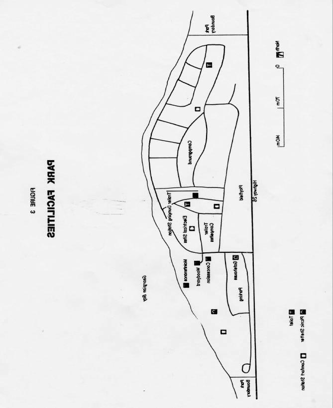
10 5
11 station, playing field, gatehouse, parking lot, picnic tables, residence/park office, maintenance and storage buildings and concession building. Features of interpretive value within his zone include the abundance of fossils along the shoreline and the historic oil shale works. (b) Open Fields This area of about 21 hectares (51.2 acres) is located south of Highway 26 between the railway line and the foot of the Lake Nipissing remn ant shore - line. It is a flat plain of lacustrine deposits made up of three abandoned agricultural fields. At present this area supports varying successional stages of vegetation. Any future development that occurs at Craigleith Provincial Park will be established in this area. A septic tile bed will be built in a small part of this area. As well, this area would be the location of any new and/or relocated campsites and expanded - recreational facilities such as a swimming pool and a fitness trail. Future development in this zone will require an approved development plan and subsequent site plans. Natural Environment Zone This area, the clay slope forest, is about 22 hectares (54.4 acres) and is made up of the glacial Lake Nipissing reline and part of the plateau above The fragile, unstable nature of slope makes it sensitive to disturbance. The removal of vegetation will not be permitted in order to minimize soil slippage and vial erosion. The interpretive value of this area is high. The Lake Nipissing shoreline is an example of the geomorphologic history of the area. The vegetation successional stages on the remnant shoreline are noteworthy. 6 provided below. Although the policies are presented in separate categories, all planning and management will recognize that the components are inter-related and that an integrated approach will be required in order for the park to achieve its objectives. 3.1 Vegetation A Vegetation Management Plan will be developed for the park to outline future vegetation management for the park. The plan should include continued planting in the day-use/ camping area. Only native species representative of the local environment will be planted. As well trees may be removed for development or management purposes provided the removal is consistent with objectives related to visitor safety, aesthetics and conservation of natural and cultural values. In the open fields of the Development Zone the Vegetation Management Plan should include the maintenance of the hedgerows because of their value as wildlife habitat and corridors; planting around the edges to act as a buffer, this is especially important along the railway line and where residences are located. As well planting in the fields should be considered to return them to a forested state. A variety of species should be planted in order to establish a diversified area. In the Natural Environment Zone, the Vegetation Management Plan should indicate that only management related to visitor safety and conservation of natural values will be undertaken. Commercial forest operations will not be permitted within Craigleith Provincial Park. Access to this area will be limited to walking trails only. 3.0 RESOURCE MANAGEMENT The park s natural and cultural resources will be managed in accord ance with the general planning and management policies for recreation class parks. Specific direction, where needed to meet the requirements of Craigleith Provincial Park, is
12 7 All fires except campfires within the park will be attacked aggressively by park staff and the local fire department to keep damage to an absolute minimum. Forest and vegetative insects and diseases that threaten values within the park will be controlled where feasible with minimal adverse environmental impact. 3.2 Wildlife Hunting and commercial trapping will not be permitted within the park. Limited authorized trapping (e.g. beaver) may be carried out, as required, for the purpose of protecting park values. 3.3 Fish Sport fishing (e.g. rainbow trout and lake trout backcross) from the shoreline of Georgian Bay will be encouraged. 3.4 Landforms The earth science features in the park will be conserved and protected. The contact between the Whitby shale and the Lindsay limestone, which occurs along the shoreline, is a regionally significant feature. Fossils are abundant along the beach and are mostly from the Lindsay limestone. Removal of fossils from the park will not be permitted. The visitor services program and exhibits will encourage the observation of fossils without collecting. Shoreline improvement work will only be undertaken if it will not destroy the feature or hinder the observation of it. The outcrop of Whitby shale south of Highway 26 at Hidden Lake Road is of local significance. These exposures are recognized for their educational and interpretive value. The Lake Nipissing remnant shoreline within the park and the Lake Algonquin shoreline and the Niagara Escarpment, both south of the park are important features for interpreting the geological history of the area. 3.5 Cultural Resources The area has an interesting history dating back to the l600s when Petun Indians inhabited the area. The early settlers economy was very dependent on the natural resources. The industry included furniture manufacturing, limestone quarrying, extraction of oil from shale and shipping. An information board and display will be used to convey historical information and the evening program schedule to the park visitors. 4.0 CLIENT SERVICES 4.1 Visitor Services The Visitor Services Program will provide visitors with recreation opportunities related to understanding and appreciating the features in the park and the surrounding area as well as provide a window to local Ministry of Natural Resources integrated resource management programs. This will be achieved through the following components of a visitor services program Public Information Information concerning park resources, management, facilities, programs and nearby points of interest will be available at key points throughout the park (i.e. park office, main gate). Information will be provided through such means as a park newspaper tabloid, staff, display and notice boards and concession building. Self use facilities such as the fossil display, historical plaques and signs will be made available to the park visitor. Visitor services programs will be provided during July and August. Information about nearby features and attractions will be made available to the public Recreation
13 8 The recreation program will promote the visitor s personal involvement in the park and surrounding area. Recreation programs may include local tourist attractions and presentations [by agencies and groups that relate to the enjoyment of the natural environment. The park will provide opportunities for intensive recreational activities such as camping, picnicking, swimming, boating, fishing and open space playing. As well visitors will be made aware of opportunities outside the park such as hiking (Bruce Trail), beaches (Wasaga leach), scenic drives (Beaver and Pretty River Valleys), canoeing (Beaver River) and boardsailing. 4.l.3 Interpretation The interpretive program will seek to create a greater understanding of the natural and cultural values of the park. Aspects of the program will consider the geological and historical features of the park, which are of regional and local significance. They will be interpreted through printed material, self-use facilities such as displays, informal personal contact and visitor services programs. 4.2 Research Scientific research by qualified individuals, which contributes to the knowledge of the natural and cultural features of the park, or recreational user statistics will be encouraged. 11 research programs will require the approval of the Ministry of Natural Resources. 4.3 Commercial Services The concession building will continue to be operated to provide visitors with convenience foods, basic grocery supplies, ice and sundries. In addition to groceries, the building houses an information/bulletin board, a small geological display and a publication storage area. The woodyard will be open for the daily sale of firewood at posted times. spring and fall seasons, to increase involvement with the commercial sector by encouraging park users to use and take advantage of local tourist services and attractions, and generally stimulate interaction between the park and the private tourist and commercial sector in the vicinity. 5.0 DEVELOPMENT All development will be carried out in accordance with approved site plans and development plans. The Owen Sound District Land Use Guidelines, 1983 indicate that 10 additional day use picnic tables and up to 170 additional campsites will be provided at Craigleith Provincial Park by the year If the demand for camping and day use opportunities in the area increases and the private sector is unable to meet this demand, then the Ministry will consider expansion of Craigleith Provincial Park. Any expansion and development within the existing park boundaries will be carried out after consultation with local private camp ground operators, municipalities and the public. Any expansion of park campsites would occur in the park area south of Highway 26 in the open fields. This would require the provision of an appropriate link to the day use area and other facilities north of the highway and overcoming the perception that this would not be a desirable area to camp in, as it is further from the water. Recent high water levels have created a serious problem along the shoreline. A number of campsites and a road in front of them have been damaged. With high levels persisting, the day use comfort station, the maintenance building and additional areas in the campgrounds are being threatened. The damaged campsites will be closed until the hazardous lake levels drop again. Campsites will be established in the day use 4.4 Marketing A marketing plan will be prepared to attract more visitors during low-use periods in the mid week and
14 9 area as a temporary measure to maintain camping opportunities during this period of high lake levels. Also, appropriate erosion protection limited to protecting the maintenance building, day use comfort station and shoreline in front of the camping area is required to safeguard these facilities. This erosion protection work has been carefully site planned to minimize impact upon the regionally significant fossil beds along the shoreline. The ground cover in the camping area is showing signs of damage due to the intensive use of this are a. Little natural regeneration is occurring and planted stock is not fairing well. Both of these conditions should be monitored. If the problems of high water levels and/or difficulties with campsite rehabilitation persist then it may be necessary to reduce the number of campsites or to move some or all of the campsites to the open fields south of the highway. The result of moving all campsites would be to use the entire section north of the highway for day use only. If the proposed pedestrian walkway system through the Craigleith/Campderdown area is established the park would be linked to it. Park facilities would be available to pedestrian traffic. Now that the park is connected to the municipal water system a shower building will be built in the camp grounds. This will necessitate an expansion of the septic system. The new tile bed will be located south of Highway 26. The sewage will have to be pumped under the road from a holding tank built into the shower/comfort station building. At such time as a municipal sewage system becomes available, due consideration will be given to connecting the park to it. In order to facilitate future development a number of specific plans should be prepared. These are a vegetation plan, a site development plan and an operations plan. 6.0 IMPLEMENTATION The management plan will be reviewed in 10 years following its approval, or earlier if the need arises. As funds and priorities permit, additional research will be conducted on natural and cultural values, and recreational user demands, to provide a basis for future reviews of the plan. 7.0 PUBLIC CONSULTATION The following steps were taken to incorporate public consultation in the preparation of the Craigleith Provincial Park Management Plan. A mailing list was prepared consisting of interest groups, municipalities, government agencies and members of Parliament and the Legislature. Fifteen copies of the draft management plan were mailed out on July 28, 1986 with five responses being received by the August 28, 1986 deadline for public comment. A news release was mailed out on July 24, 1986 and a newspaper advertisement was placed in the local newspapers during the last week of July These efforts were designed to inform people of the preparation of the management plan and that copies of the draft plan were available at the Owen Sound District Office and at the park. The results of the various communication efforts were seven separate letters raising seventeen issues. Based upon Ministry of Natural Resources staff discussions and external input, the final plan was prepared, approved and copies sent to the municipalities, members of Parliament and the Legislature and other interested parties. The park management plan will be reviewed in ten years following its approval or earlier if the need arises. As funds and priorities permit, additional research will be conducted on natural and cultural values and recreational user demands to provide a basis for future reviews of the plan.
15 10 REFERENCES Hills, G. A. A Ready Reference to the Description of the Land of Ontario and its Productivity, Ontario Department of Lands and Forests, Ministry of Natural Resources. Ontario Provincial Parks Statistics, Parks and Recreation Branch, Queen s Park, 1983, 1982, 1981, 1980, 1979, 1978, 1977, 1976, 1975, 1974, Ministry of Natural Resources. Master Planning Directive for the Proposed Craigleith Provincial Park, Owen Sound District. December 1975 a. Ministry of Natural Resources. Park Policy Direction Statement - Craigleith b. Ministry of Natural Resources. Ontario Provincial Parks Planning and Management Policies Ministry of Natural Resources. Craigleith Provincial Park - Acquisition Boundary, Land Ownership Inventory and Recommendations. Prepared by Walter Schmid, Owen Sound District, June Ministry of Natural Resources. Craigleith Provincial Park Background Information, Owen Sound District. January Ministry of Natural Resources. Craigleith Provincial Park Draft Management Plan, Owen Sound District. July 30, Ministry of Natural Resources. Report of the Task Force on Parks System Planning. Parks System Planning Program. September Ministry of Natural Resources. Owen Sound District Land Use Guidelines a. Ministry of Natural Resources Provincial Park Camper Survey Summary Statistical Report. Outdoor Recreation Group. December, 1983 b. Ministry of Natural Resources. Fisheries Management Plan - Background Information. Owen Sound District. March 1983 C. Ministry of Natural Resources Provincial Park Day User Survey - Summary Statistical Report. Outdoor Recreation Group. December Provincial Secretariat for Resource Development. The Niagara Escarpment Plan. July Rahm, Linda. Market Area Analy sis for the Proposed Pretty River, Craigleith and Kolapore Uplands Recreation Areas. Ministry of Natural Resources, Owen Sound Rhodes, 3. A Reconnaissance Life Science Inventory of Craigleith Provincial Park. Ministry of Natural Resources, Southwestern Region Verma, Harish M. Geology and Fossils Craigleith Area, Ontario. Ontario Geological Survey, Guidebook #7, Ministry of Natural Resources
Bayview Escarpment. Interim Management Statement
 Bayview Escarpment Interim Management Statement Bayview Escarpment Provincial Nature Reserve Interim Management Statement January 15, 1995 REGIONAL DIRECTOR'S APPROVAL STATEMENT This Interim Management
Lion s Head. Interim Management Statement
 Lion s Head Interim Management Statement Lion's Head Provincial Nature Reserve Interim Management Statement July 14, 1997 APPROVAL STATEMENT This Interim Management Statement will provide interim direction
Approval Statement. Brian Pfrimmer, Central Zone Manager Ontario Parks
 Approval Statement I am pleased to approve this Interim Management Statement for Dividing Lake Provincial Nature Reserve. This Nature Reserve contains biological features of provincial significance and
Nakina Moraine Provincial Park. Interim Management Statement. Ontario. Ministry of Natural Resources
 Nakina Moraine Provincial Park Interim Management Statement Ontario Ministry of Natural Resources 1999, Queen's Printer for Ontario Printed in Ontario, Canada Additional copies of this publication can
ISBN c 1988 Government of Ontario Printed in Ontario, Canada
 Single copies of this publication are available for $2.00 from the Ontario Ministry of Natural Resources, Espanola District Office, P.O. Box 1340, 148 Fleming Street, Espanola, Ontario, POP 1CO, telephone:
Ouimet Canyon Provincial Nature Reserve. Management Plan
 Ouimet Canyon Provincial Nature Reserve Management Plan NOTE: This document has been scanned and formatted, and therefore is slightly different from the original version. -March 2002 Additional copies
Yard Creek Provincial Park. Management Plan
 Yard Creek Provincial Park Management Plan Draft January 2010 Yard Creek Provincial Park Management Plan Approved by: telàlsemkin/siyam/chief Scott Benton Bill Williams Squamish Executive Director ation
Watchorn Provincial Park. Management Plan
 Watchorn Provincial Park Management Plan 2 Watchorn Provincial Park Table of Contents 1. Introduction... 3 2. Park History... 3 3. Park Attributes... 3 3.1 Natural... 4 3.2 Recreational... 4 3.3 Additional
Smoky Head White Bluff. Interim Management Statement
 Smoky Head White Bluff Interim Management Statement Smoky Head - White Bluff Provincial Nature Reserve Interim Management Statement March 1, 1997 APPROVAL STATEMENT This Interim Management Statement will
Dividing Lake Provincial Nature Reserve
 - Do Not Remove i, '" i ' Dividing Lake Provincial Nature Reserve I!.' Interim Management Statement Amendment 2001-001 Park Boundary Amendment Approved: r.in'r entral Zone, Ontario Parks PJ Date 2. ()/
PARK MANAGEMENT PLANNING SERIES STURGEON BAY PROVINCIAL PARK MANAGEMENT PLAN
 PARK MANAGEMENT PLANNING SERIES STURGEON BAY PROVINCIAL PARK MANAGEMENT PLAN MNR 3477 ISBN 0 7729 1018 9 1986 Government of Ontario Limited copies of this publication are obtainable at the Ministry of
Port Bruce. Interim Management Statement
 Port Bruce Interim Management Statement Port Bruce Interim Management Statement August 3, 1999 This Port Bruce Provincial Park Interim Management Statement provides direction for the custodial management
MANAGEMENT DIRECTION STATEMENT June, 1999
 Thompson River District MANAGEMENT DIRECTION STATEMENT June, 1999 for Roche Lake Provincial Park Ministry of Environment Lands and Parks BC Parks Division Table of Contents I. Introduction A. Setting
ANAGEMENT. LAN November, 1996
 M ANAGEMENT P LAN November, 1996 for Paul Lake Provincial Park Ministry of Environment, Lands and Parks BC Parks Department Paul Lake Provincial Park M ANAGEMENT P LAN Prepared by BC Parks Kamloops Area
Whitemouth Falls Provincial Park. Draft Management Plan
 Whitemouth Falls Provincial Park Draft Management Plan Whitemouth Falls Provincial Park Draft Management Plan Table of Contents 1. Introduction... 3 2. Park History... 3 3. Park Attributes... 4 3.1 Natural...
Wallace Lake Provincial Park. Management Plan
 Wallace Lake Provincial Park Management Plan 2 Wallace Lake Provincial Park Table of Contents 1. Introduction... 3 2. Park History... 3 3. Park Attributes... 4 3.1 Natural... 4 3.2 Recreational... 4 4.
MANAGEMENT DIRECTION STATEMENT June, 1999
 Thompson River District MANAGEMENT DIRECTION STATEMENT June, 1999 for Clearwater River Corridor (Addition to Wells Gray Park) Ministry of Environment Lands and Parks BC Parks Division ii Table of Contents
ROBERTS CREEK PROVINCIAL PARK MASTER PLAN. November, 1981
 Ministry of Lands, Parks and Housing Parks and Outdoor Recreation Division Park Operations Branch North Vancouver, B. C. ROBERTS CREEK PROVINCIAL PARK MASTER PLAN November, 1981 Mr. G. Trachuk Director
Pembina Valley Provincial Park. Draft Management Plan
 Pembina Valley Provincial Park Draft Management Plan 2 Pembina Valley Provincial Park Table of Contents 1. Introduction... 3 2. Park History... 3 3. Park Attributes... 3 3.1 Natural... 3 3.2 Recreational...
Boyne Valley Provincial Park. Interim Management Statement
 Boyne Valley Provincial Park Interim Management Statement January 20, 1995 REGIONAL DIRECTOR'S APPROVAL STATEMENT This Interim Management Statement will provide interim direction for the management of
KANANASKIS COUNTRY PROVINCIAL RECREATION AREAS MANAGEMENT PLAN DRAFT TERMS OF REFERENCE - November 20, 2007
 KANANASKIS COUNTRY PROVINCIAL RECREATION AREAS MANAGEMENT PLAN DRAFT TERMS OF REFERENCE - November 20, 2007 BACKGROUND There are 42 Provincial Recreation Areas (PRAs) within Kananaskis Country located
 March 25, 1994 To: Re: MEMO TO FILE MINOR AMENDMENT - PINERY PROVINCIAL PARK MANAGEMENT PLAN The following paragraph from page 5 of the Pinery Provincial Park Management Plan (ISBN 0-7729-0290-9) lnsects
Beaver Creek Provincial Park. Management Plan
 Beaver Creek Provincial Park Management Plan 2 Beaver Creek Provincial Park Table of Contents 1. Introduction... 3 2. Park History... 3 3. Park Attributes... 4 3.1 Natural... 4 3.2 Recreational... 4 4.
Clearwater Lake Provincial Park. Draft Management Plan
 Clearwater Lake Provincial Park Draft Management Plan Clearwater Lake Provincial Park Draft Management Plan Table of Contents 1. Introduction... 3 2. Park History... 4 3. Park Attributes... 4 3.1 Location/Access...4
Preferred Recreation Recommendations Stemilt-Squilchuck Recreation Plan March 2018
 Preferred Recreation Recommendations Stemilt-Squilchuck Recreation Plan March 2018 Below are the recommended recreation ideas and strategies that package together the various recreation concepts compiled
ANAGEMENT. LAN November, 1996
 M ANAGEMENT P LAN November, 1996 for Coldwater River Provincial Park Ministry of Environment, Lands and Parks BC Parks Department Coldwater River Provincial Park M ANAGEMENT P LAN Prepared by BC Parks
Wallace Lake Provincial Park. Draft Management Plan
 Wallace Lake Provincial Park Draft Management Plan Wallace Lake Provincial Park Draft Management Plan Table of Contents 1. Introduction... 3 2. Park History... 3 3. Park Attributes... 4 3.1 Natural...
Samuel de Champlain Provincial Park Management Plan
 Samuel de Champlain Provincial Park Management Plan Ontario Ministry of Natural Resources Cover Photo: Tracking the Rapids c. 1891 (detail) Francis Anne Hopkins (1838-1919) Sigmund Samuel Collection, Royal
Numaykoos Lake Provincial Park. Management Plan
 Numaykoos Lake Provincial Park Management Plan 2 Numaykoos Lake Provincial Park Table of Contents 1. Introduction... 3 2. Background... 3 3. Park Purpose... 5 4. Park Management Guidelines... 6 Appendix...
Ojibway Provincial Park. Management Plan
 Ojibway Provincial Park Management Plan ISBN O-7729-9448-X 1992, Queen s Printer for Ontario Printed in Ontario, Canada Single copies of this publication are available at no charge from the address noted
Planning and Building Department
 Page 1 of Report PB-27/11 CITY OF Burlington Planning and Building Department TO: Chair and Members of the Community Development Committee SUBJECT: Niagara Escarpment Plan Amendment 179 (NEPA 179) Addition
NOV UPPER MADAWASKA RIVER PROVINCIAL PARK INTERIM MANAGEMENT STATEMENT. Ontario
 NOV 1 3 2001 UPPER MADAWASKA RIVER PROVINCIAL PARK INTERIM MANAGEMENT STATEMENT Ontario . BACKGROUND INFORMATION NAME: Upper Madawaska River REGIONAL SETTING MAP PROPOSED CLASS: U.N.R. DISTRICT: U.N.R.
Land Management Summary
 photo credit: ANGAIR Anglesea Heath Land Management Summary The Anglesea Heath (6,501 ha) was incorporated into the Great Otway National Park in January 2018. This provides an opportunity to consider the
482 :fi6 D34 --' v.i9 ~
 '- SB 482 :fi6 D34 --' v.i9 ~ This document is made available electronically by the Minnesota Legislative Reference Library as part of an ongoing digital archiving project. http://www.leg.state.mn.us/lrl/lrl.asp
Connie Rudd Superintendent, Black Canyon of the Gunnison National Park
 National Park Service U.S. Department of the Interior Black Canyon of the Gunnison National Park and Curecanti National Recreation Area Information Brochure #1 Wilderness and Backcountry Management Plan
Norris Lake Provincial Park. Draft Management Plan
 Norris Lake Provincial Park Draft Management Plan 2 Norris Lake Provincial Park Table of Contents 1. Introduction... 3 2. Park History... 3 3. Park Attributes... 4 3.1 Natural... 4 3.2 Recreational...
NEPOSS. 131 Parks 11/8/2010. The Niagara Escarpment Parks and Open Space System Ken Whitbread, Manager, Niagara Escarpment Commission
 The Niagara Escarpment Parks and Open Space System Ken Whitbread, Manager, Niagara Escarpment Commission NEP approved in 1985 Reviewed in 1994 & 2005 Plan has land use designations and identifies Public
Limestone Islands. Park Management Plan
 Limestone Islands Park Management Plan MNR 51643-1 ISBN 0-7794-3580-X 2002 Queen s Printer of Ontario Printed in Ontario, Canada Cover Photo: Henry Kujala Additional copies of this publication can be obtained
Sand Lakes Provincial Park. Draft Management Plan
 Sand Lakes Provincial Park Draft Management Plan 2 Sand Lakes Provincial Park Table of Contents 1. Introduction... 3 2. Background... 3 3. Park Purpose... 5 4. Park Management Guidelines... 6 Appendix...
Appendix A BC Provincial Parks System Goals
 Appendix A BC Provincial Parks System Goals The British Columbia Provincial Parks System has two mandates: To conserve significant and representative natural and cultural resources To provide a wide variety
Serpent Mounds Provincial Park Management Plan
 Serpent Mounds Provincial Park Management Plan ~ Ministry of...v ~ Natural Resources - Ontario I Additional copies of this publication are obtainable from: Ministry of Natural Resources 10670 Yonge street
Pillar Park. Management Plan
 Pillar Park Management Plan January 2014 Pillar Park Management Plan Approved by: Jeff Leahy Regional Director Thompson Cariboo Region BC Parks January 9, 2014 Date Brian Bawtinheimer Executive Director
PROPOSAL FOR RECLASSIFICATION, BOUNDARY AMENDMENT AND DRAFT CONCEPT PLAN FOR SASKATOON MOUNTAIN NATURAL AREA. Frequently Asked Questions
 PROPOSAL FOR RECLASSIFICATION, BOUNDARY AMENDMENT AND DRAFT CONCEPT PLAN FOR SASKATOON MOUNTAIN NATURAL AREA 1. Why is this proposal being put forward? Frequently Asked Questions For many years, Alberta
As outlined in the Tatshenshini-Alsek Park Management Agreement, park management will:
 Management Strategy General Strategy The priority management focus for the park is to ensure that its internationally significant natural, cultural heritage and recreational values are protected and that
Proposal to Redevelop Lower Kananaskis River-Barrier Lake. Bow Valley Provincial Park. Frequently Asked Questions
 Proposal to Redevelop Lower Kananaskis River-Barrier Lake Bow Valley Provincial Park Frequently Asked Questions What is being proposed? What are the details of the proposal? Where is the project area located?
Sasagiu Rapids Provincial Park. Draft Management Plan
 Sasagiu Rapids Provincial Park Draft Management Plan 2 Sasagiu Rapids Provincial Park Table of Contents 1. Introduction... 3 2. Background and Park Attributes... 3 2.1 Park History.... 3 2.2 Natural Features...
Lake Tahoe Shoreline Plan 03 Policy Topic: Access Issues
 Lake Tahoe Shoreline Plan 03 Policy Topic: Access Issues V9 Last Updated 03.10.2017 1 Brief Description Physical access to the waters of Lake Tahoe is one of the key issues surrounding the Shoreline Plan
DRAFT. Dorabelle Campground Rehabilitation
 DRAFT Dorabelle Campground Rehabilitation September 2012 1.1 REGIONAL SETTING AND PROJECT LOCATION The Dorabelle Campground is located on the western shore of Shaver Lake in Fresno County, California (Section
MAIN LAKE PROVINCIAL PARK
 MAIN LAKE PROVINCIAL PARK PURPOSE STATEMENT AND ZONING PLAN March 2003 MAIN LAKE PROVINCIAL PARK Purpose Statement and Zoning Plan Primary Role The primary role of Main Lake Park is to protect a biologically
~,t;b i D34 Vs33 SB 482
 ., SB 482 ~,t;b i D34 Vs33 This document is made available electronically by the Minnesota Legislative Reference Library as part of an ongoing digital archiving project. http://www.leg.state.mn.us/lrl/lrl.asp
FINGER-TATUK PROVINCIAL PARK
 FINGER-TATUK PROVINCIAL PARK PURPOSE STATEMENT AND ZONING PLAN March 2003 FINGER-TATUK PROVINCIAL PARK Purpose Statement and Zoning Plan Finger-Tatuk Provincial Park is 17,151 ha in size. It includes the
Oxtongue River- Ragged Falls Provincial Park. Management Plan
 Oxtongue River- Ragged Falls Provincial Park Management Plan 4279 0-7729-4782-1 1990, Queens Printer for Ontario Printed in Ontario, Canada Limited copies of this publication are obtainable from: Ministry
This document is made available electronically by the Minnesota Legislative Reference Library as part of an ongoing digital archiving project.
 This document is made available electronically by the Minnesota Legislative Reference Library as part of an ongoing digital archiving project. http://www.leg.state.mn.us/lrl/lrl.asp (Funding for document
Marchand Provincial Park. Management Plan
 Marchand Provincial Park Management Plan 2 Marchand Provincial Park Table of Contents 1. Introduction... 3 2. Park History... 3 3. Park Attributes... 4 3.1 Natural... 4 3.2 Recreational... 4 3.3 Additional
APPENDIX. Alberta Land Stewardship Act AMENDMENTS TO THE SOUTH SASKATCHEWAN REGIONAL PLAN
 APPENDIX Alberta Land Stewardship Act AMENDMENTS TO THE SOUTH SASKATCHEWAN REGIONAL PLAN 1 All references to Alberta Environment and Sustainable Resource Development, Environment and Sustainable Resource
Criddle/Vane Homestead Provincial Park. Management Plan
 Criddle/Vane Homestead Provincial Park Management Plan 2 Criddle/Vane Homestead Provincial Park Table of Contents 1. Introduction... 3 2. Park History.... 3 3. Park Attributes.... 4 3.1 Natural.... 4 3.2
AMENDMENT NO. 03 TO THE OFFICIAL PLAN FOR THE TOWNSHIP OF ADJALA-TOSORONTIO OAK RIDGES MORAINE CONSERVATION PLAN
 AMENDMENT NO. 03 TO THE OFFICIAL PLAN FOR THE TOWNSHIP OF ADJALA-TOSORONTIO OAK RIDGES MORAINE CONSERVATION PLAN Adopted by Council July 19 th, 2004 Approved with modifications by the Province of Ontario
Niagara Natural Heritage Park
 A Future Proposal For the Niagara-on-the-Lake DND Lands....... Parks Canada Lakeshore Road Property 1 May, 2016 The Harmony Residents Group We are proposing a Natural Heritage Park be established on the
PROPOSED PARK ALTERNATIVES
 8 Chimne y Rock State Park M a ster Pl an 2011 PROPOSED PARK ALTERNATIVES Introduction Three different park development concepts were prepared and presented to the citizens of North Carolina through a
Pinawa Provincial Park. Draft Management Plan
 Pinawa Provincial Park Draft Management Plan Pinawa Provincial Park Draft Management Plan Table of Contents 1. Introduction... 3 2. Park History... 3 3. Park Attributes... 4 3.1 Natural... 4 3.2 Recreational...
Cavern Lake Provincial Nature Reserve. Management Plan
 Cavern Lake Provincial Nature Reserve Management Plan NOTE: This document has been scanned and formatted, and therefore is slightly different from the original version. - March 2002 Additional copies of
Ontario. Tide Lake Provincial Nature Reserve. Interim Management Statement. Ministry of Natural Resources
 Ontario Tide Lake Provincial Nature Reserve nterim Management Statement Ministry of Natural Resources Tide Lake Provincial Nature Reserve nterim Management Statement Ontario Ministry of Natural Resources
Manitou Islands Provincial Nature Reserve Management Plan
 Manitou Islands Provincial Nature Reserve Management Plan Ministry of Natural Resources Ontario 1990 Queen s Printer for Ontario Printed in Ontario, Canada Single copies of this publication can be obtained
Rocky Lake Provincial Park. Draft Management Plan
 Rocky Lake Provincial Park Draft Management Plan Rocky Lake Provincial Park Draft Management Plan Table of Contents 1. Introduction... 3 2. Park History... 3 3. Park Attributes... 4 3.1 Location/Access...4
SANTA-BOCA PROVINCIAL PARK
 SANTA-BOCA PROVINCIAL PARK PURPOSE STATEMENT AND ZONING PLAN March 2003 SANTA-BOCA PROVINCIAL PARK Purpose Statement and Zoning Plan Primary Role The primary role of Santa-Boca Park is to provide marine-based
CRAZY HORSE TRAIL GUIDE
 CRAZY HORSE TRAIL GUIDE Abridged Version: July 2016 This is a short form of our interpretive trail guide for the Crazy Horse Trail. The full version of the guide has a more detailed description of the
2.0 PARK VISION AND ROLES
 2.0 PARK VISION AND ROLES 2.1 Significance in the Protected Area System Marble Range and Edge Hills provincial parks protect 6.8% of the Pavillion Ranges Ecosection, which is located in the Southern Interior
Conservation Area Management Statement
 Conservation Area Management Statement Miller Creek Wildlife Area Resolution #: Approval: Issue Date: Date of Last Revision: Table of Contents 1. Purpose....... 1 2. Property Description...... 1 2.1. Legal
SUMMER VILLAGE OF SILVER SANDS. Municipal Development Plan
 SUMMER VILLAGE OF SILVER SANDS Municipal Development Plan Bylaw 253-2014 Adopted August 22, 2014 Summer Village of Silver Sands Municipal Development Plan Bylaw No. 253-2014 Page 2 1 INTRODUCTION 1.1 SETTING
1 INFORMATION REQUIREMENTS
 1 INFORMATION REQUIREMENTS 1.1 BACKGROUND 2 1.2 WHAT IS THE DISTRICT PLAN 3 1.3 DISTRICT PLAN STRUCTURE 4 1.4 HOW TO USE THE DISTRICT PLAN 5 1.5 STRATEGIC FRAMEWORK 6 Whanganui District Plan (15 January
Recreation in the Battle River Basin: Overview. John Thompson, Watrecon Consulting
 Recreation in the Battle River Basin: Overview John Thompson, Watrecon Consulting Recreation Rates for Alberta & Battle Basin Households 1996 2004 Battle Basin Alberta Battle Basin Alberta Bird Watching
ANAGEMENT P LAN. February, for Elk Lakes and Height of the Rockies Provincial Parks. Ministry of Environment, Lands and Parks BC Parks Division
 M ANAGEMENT P LAN February, 1999 for Elk Lakes and Height of the Rockies Provincial Parks Ministry of Environment, Lands and Parks BC Parks Division Elk Lakes & Height of the Rockies Provincial Parks M
White Lake Peatlands. Interim Management Statement
 White Lake Peatlands Interim Management Statement 2007 APPROVAL STATEMENT I am pleased to approve this Interim Management Statement for White Lake Peatlands Provincial Park. This park was regulated under
PLUMPER COVE MARINE PARK MASTER PLAN
 Lower Mainland Region Park Operations Branch Parks and Outdoor Recreation Division Ministry of Lands, Parks and Housing North Vancouver, B.C. PLUMPER COVE MARINE PARK MASTER PLAN DECEMBER, 1980 PLUMPER
Finn Creek Park. Management Direction Statement Amendment
 Finn Creek Park Management Direction Statement Amendment November 2013 Management Direction Statement Amendment Approved by: Jeff Leahy Regional Director, Thompson Cariboo BC Parks November 12, 2013 Date
Winnipeg Beach Provincial Park. Draft Management Plan
 Winnipeg Beach Provincial Park Draft Management Plan 2 Winnipeg Beach Provincial Park Table of Contents 1. Introduction... 3 2. Park History... 3 3. Park Attributes... 4 3.1 Natural...4 3.2 Recreational...4
Little Limestone Lake Provincial Park. Draft Management Plan
 Little Limestone Lake Provincial Park Draft Management Plan Little Limestone Lake Provincial Park Draft Management Plan Table of Contents 1. Introduction... 3 2. Background... 3 3. Planning context...
Ministry of Parks, Culture and Sport. Plan for saskatchewan.ca
 Ministry of Parks, Culture and Sport Plan for 2018-19 saskatchewan.ca Table of Contents Statement from the Minister... 1 Response to Government Direction... 2 Operational Plan... 3 Highlights... 7 Financial
Criddle/Vane Homestead Provincial Park. Draft Management Plan
 Criddle/Vane Homestead Provincial Park Draft Management Plan 2 Criddle/Vane Homestead Provincial Park Table of Contents 1. Introduction... 3 2. Park History.... 3 3. Park Attributes.... 3 3.1 Natural....
Birch Point Provincial Park. Management Plan
 Birch Point Provincial Park Management Plan 2 Birch Point Provincial Park Table of Contents 1. Introduction... 3 2. Park History... 3 3. Park Attributes... 4 3.1 Natural... 4 3.2 Recreational... 4 4. Park
Buck Island Reef National Monument News Release Date: Immediate Contact: Joel Tutein, Superintendent, x 222
 National Park Service U.S. Department of the Interior www.nps.gov 2100 Church Street, # 100 Christiansted, VI 00820 News Release Date: Immediate Contact: Joel Tutein, Superintendent, Joel.Tutein@nps.gov
5.0 OUTDOOR RECREATION OPPORTUNITIES AND MANAGEMENT
 5.0 OUTDOOR RECREATION OPPORTUNITIES AND MANAGEMENT 5.1 Introduction This section describes the range of recreational activities that currently take place in Marble Range and Edge Hills Parks, as well
Fossil Creek Wild & Scenic River Comprehensive River Management Plan Forest Service Proposed Action - details March 28, 2011
 Fossil Creek Wild & Scenic River Comprehensive River Management Plan Forest Service Proposed Action - details March 28, 2011 Primary Goals of the Proposed Action 1. Maintain or enhance ORVs primarily by
Rogue River Access and Management Plan Draft Alternatives
 Rogue River Access and Management Plan Draft Alternatives The Rogue River Access and Management Plan was initiated in December, 2011 and is being led by Jackson County Parks (JCP) and Oregon Department
Welcome to the future of Terwillegar Park a Unique Natural Park
 Welcome to the future of Terwillegar Park a Unique Natural Park 1 Introduction The Terwillegar Park Concept Plan study will develop an overall concept plan, management objectives and development guidelines
MANAGEMENT DIRECTION STATEMENT
 Skeena District MAAGEMET DIRECTIO STATEMET July, 2000 for Driftwood Canyon Provincial Park Ministry of Environment Lands and Parks BC Parks Division i Table of Contents Driftwood Canyon Park Approvals
SANBI PLANNING FORUM
 SANBI PLANNING FORUM SPATIAL PLANNING IN PROTECTED AREAS AND THEIR BUFFERS (South Africa) Ms Jayshree Govender, Dr Mike Knight and Mr Russell Smart 22 June 2017 OUTLINE 1) Introduction 2) Protected areas
Adventure Tourism Management Plan. Adventure Tourism Intensive Use Sites MANAGEMENT PLAN
 Adventure Tourism Intensive Use Sites MANAGEMENT PLAN ACCEPTED BY: FILES #: 1413906 1413905 LICENSES #: 112857 112905 DATE: April 25, 2018 SIGNED on behalf of HER MAJESTRY THE QUEEN IN THE RIGHT OF THE
Planning & Building Department
 Page 1 of Report Planning & Building Department To: Subject: Community Development Committee Protecting Escarpment Rural Land (PERL) Proposed Niagara Escarpment Plan Amendment Niagara Escarpment Commission
Grundy Lake. Provincial Park. Management Plan
 Grundy Lake Provincial Park Management Plan 819 0-7729-2268-03 1988, Queen s Printer for Ontario Printed in Ontario, Canada Limited copies of this publication are obtainable from: Ministry of Natural Resources
Segment 2: La Crescent to Miller s Corner
 goal of the USFWS refuges is to conserve, protect and enhance fish, wildlife and plants and their habitats for the continuing benefit of the American people. Refuge lands are used largely for fishing,
Steel River Provincial Park. Interim Management Statement. Ministry of Natural Resources. Ontario. Ministry of Natural Resources.
 Steel River Provincial Park Interim Management Statement Ontario Ministry of Natural Resources (j) Ontario Ministry of Natural Resources Additional copies of this publication are obtainable only from:
MANAGEMENT DIRECTION STATEMENT March 2003
 Skeena Region MAAGEMET DIRECTIO STATEMET March 2003 for Meziadin Lake Provincial Park Ministry of Water, Land and Air Protection Environmental Stewardsh Division This page left blank on purpose ii Table
THUNDER HILL PROVINCIAL PARK
 THUNDER HILL PROVINCIAL PARK PURPOSE STATEMENT AND ZONING PLAN February 2003 Approved by: THUNDER HILL PROVINCIAL PARK Purpose Statement and Zoning Plan Primary Role The primary role of Thunder Hill Provincial
METROPOLITAN COUNCIL 390 North Robert Street, St. Paul, MN Phone (651) TDD (651)
 TDD (651)") DATE: March 27, 2012 METROPOLITAN COUNCIL 390 North Robert Street, St. Paul, MN 55101 Phone (651) 602-1000 TDD (651) 291-0904 TO: Metropolitan Parks and Open Space Commission FROM: Arne Stefferud, Planning
DATE: March 27, 2012 METROPOLITAN COUNCIL 390 North Robert Street, St. Paul, MN 55101 Phone (651) 602-1000 TDD (651) 291-0904 TO: Metropolitan Parks and Open Space Commission FROM: Arne Stefferud, Planning
Ontario s Approach to Wilderness: A Policy May 1997 (Version 1.0)
") Ontario s Approach to Wilderness: A Policy May 1997 (Version 1.0) 1.0. Introduction Wilderness is important to Ontarians, important to the sustained, healthy functioning of Ontario s ecosystems. The Ministry
Ontario s Approach to Wilderness: A Policy May 1997 (Version 1.0) 1.0. Introduction Wilderness is important to Ontarians, important to the sustained, healthy functioning of Ontario s ecosystems. The Ministry
White Mountain National Forest Saco Ranger District
 United States Department of Agriculture Forest Service White Mountain National Forest Saco Ranger District 33 Kancamagus Highway Conway, NH 03818 Comm: (603) 447-5448 TTY: (603) 447-3121 File Code: 1950
MacMurchy Township End Moraine. Interim Management Statement
 MacMurchy Township End Moraine Interim Management Statement 2006 Approval Statement I am pleased to approve this Interim Management Statement for MacMurchy Township End Moraine Provincial Park (P1591).
MARBLE RIVER PROVINCIAL PARK
 MARBLE RIVER PROVINCIAL PARK PURPOSE STATEMENT AND ZONING PLAN March 2003 MARBLE RIVER PROVINCIAL PARK Purpose Statement and Zoning Plan Primary Role The primary role of Marble River Park is to protect
Section 61 Recreational Vehicle Park / Campground (Bylaw No. 2012/10)
") Part 7 General Regulations Section 61 Recreational Vehicle Park / Campground (Bylaw No. 2012/10) 61.1 A comprehensive site plan shall be provided to the satisfaction of the Development Authority that shows
Part 7 General Regulations Section 61 Recreational Vehicle Park / Campground (Bylaw No. 2012/10) 61.1 A comprehensive site plan shall be provided to the satisfaction of the Development Authority that shows