Merritts Traverse. 1928m
|
|
|
- Nathaniel Fisher
- 5 years ago
- Views:
Transcription


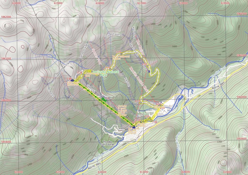
1 Merritts Traverse 3 hrs Hard track 5.8 km Circuit 4 167m This walk starts with a scenic journey to the top of the hill on the chairlift. Starting along Merritts Nature walk, this walk soon detours down the hill by following a series of signposted management trails and ski runs. The walk visits a few scenic creeks, but the main highlights are the wide views of Thredbo Valley. 1928m 1356m Kosciuszko National Park Maps, text & images are copyright wildwalks.com Thanks to OSM, NASA and others for data used to generate some map layers.

2 Covered in snow & closed part of the year Before You walk This walk leads through an extreme alpine environment and all walkers must be well prepared. During summer, be prepared for both very hot and cold weather, high winds, rain, snow, extreme UV levels and some sections of snow or ice on the ground. Before starting this walk, check advice with Snowy Region Visitor Information Centre (02) , the weather forecast and the snow conditions then change your plans as needed. These notes, grades and walking times have been written for use in the summer months only. Part of this walk is used as a groomed winter ski run. This walk is closed and should not be attempted when there is a chance of significant snow on the ground. Bushwalking is fun and a wonderful way to enjoy our natural places. Sometimes things go bad, with a bit of planning you can increase your chance of having an ejoyable and safer walk. Before setting off on your walk check Kosciuszko Express Chairlift Think before you TREK This is one of the few lifts operating in the summer months at Thredbo, and is made quite popular by thousands of people walking to the summit of Mt Kosciuszko each year. Lift tickets can be purchased from the store at the bottom of the chairlift. Lift tickets are $31 return ($25 one way) per person. This lift is generally closed during November and May for maintenance each year, but the the Snowgum chair can be used at this time instead, this will add extra walking time to you walk. More info. The 'Think before you TREK' program developed by NSW Police & NPWS promotes the benefits of planning ahead for your bushwalking trip by using an easy to remember acronym: Eagles Nest Restaurant This is Australia's highest restaurant, providing great food and outstanding views. It is easily accessible, nestled on the mountain directly opposite the top of the Kosciuszko Express chairlift, and is open year-round. For more information, call (02) Lower bench seat This small lookout on Merritts Nature Track provides a seat and a view looking north across a wide gully. A small creek cascades down the rocks through the gully. There is limited natural shade from the snow gums here. A nice place to rest and enjoy the view whilst giving your knees a rest. Top of Gunbarrel Express The top station of Gunbarrel Express provides shade, shelter and views into the valley. In winter, this chairlift provides access to the blue and green ski runs on the eastern side of Thredbo. There is a small weir behind the top station that would require treatment before drinking. 1) Weather Forecast (BOM Snowy Mountains District) 2) Fire Dangers (Monaro Alpine) 3) Park Alerts (Kosciuszko National Park) 4) Research the walk to check your party has the skills, fitness and equipment required 5) Agree to stay as a group and not leave anyone to walk solo adequate supplies of food, water, navigation and first T Take aid equipment. your planned route and tell friends and family when R Register you expect to return. beacon (PLB's) should be carried on walks with E Emergency significant gaps in mobile coverage (check terrain profile). to your planned route and follow the map and walking K Keep trails. Topo Maps The maps provided on wildwalks are helpful, but there are times where you may need maps covering a broader area. Maps that cover this walk include; 1: Map Series:85252S PERISHER VALLEY, 85241N CHIMNEYS RIDGE 1: Map Series:8525 KOSCIUSZKO, 8524 JACOBS RIVER Grade This walk has been graded using the AS The overall grade of the walk is dertermined by the highest classification along the whole track. 4 Grade 4/6 Hard track Length 5.8 km Circuit Time 3 hrs Quality of track Formed track, with some branches and other obstacles (3/6) Signs Directional signs along the way (3/6) Experience Required Some bushwalking experience recommended (3/6) Weather Storms may impact on navigation and safety (3/6) Infrastructure Generally useful facilities (such as fenced cliffs and seats) (1/6)
3 Are you ready to have fun? Please ensure you and your group are well prepared and equipped for all possible hazards and delays. Check park closures, weather information and Fire Danger Rating before setting out. Optional side trips and alternate routes noted are not included in this walks overall grade, length or time estimate. Please allow extra time for resting and exploring areas of interest. The authors, staff and owners of wildwalks take care in preparing this information but will not accept responsibility for any inconvenience, loss or injury you may experience. Please take care, have fun - Happy Walking. Getting there Traveling by car is the only practical way to get to Bottom of Kosciuszko Express chairlift (gps: , ). Car: A park entry fee is required for driving into the park. This is a circuit, so you will finish back at the start. Find up to date and more information inlcuding; travel directions, weather, park closures and walker feedback at 0 Covered in snow & closed part of the year This walk leads through an extreme alpine environment and all walkers must be well prepared. During summer, be prepared for both very hot and cold weather, high winds, rain, snow, extreme UV levels and some sections of snow or ice on the ground. Before starting this walk, check advice with Snowy Region Visitor Information Centre (02) , the weather forecast and the snow conditions then change your plans as needed. These notes, grades and walking times have been written for use in the summer months only. Part of this walk is used as a groomed winter ski run. This walk is closed and should not be attempted when there is a chance of significant snow on the ground. 0 Kosciuszko Express Chairlift This is one of the few lifts operating in the summer months at Thredbo, and is made quite popular by thousands of people walking to the summit of Mt Kosciuszko each year. Lift tickets can be purchased from the store at the bottom of the chairlift. Lift tickets are $31 return ($25 one way) per person. This lift is generally closed during November and May for maintenance each year, but the the Snowgum chair can be used at this time instead, this will add extra walking time to you walk. More info. 0 Bottom of Kosciuszko Express chairlift (1.9 km 20 mins) This walk heads into the 'Valley Terminal' building, where you can buy a ticket for the lift. Continue through the building and up the steps, where this walk turns right to find the bottom terminal of the 'Kosciuszko Express'. Walk up to the platform as directed by the chairlift operator and sit down in the seat, letting it scoop you up. Once seated, pull down the safety bar and enjoy the ride to the top of the ridge. :) At the top step of the chair lift and turn left to find the restaurant (now on your right) and track information signs ahead Eagles Nest Restaurant This is Australia's highest restaurant, providing great food and outstanding views. It is easily accessible, nestled on the mountain directly opposite the top of the Kosciuszko Express chairlift, and is open year-round. For more information, call (02) Top of Kosciuszko Express chairlift (420 m 12 mins) Turn sharp left: From the top of the chairlift, this walk heads straight downhill (keeping the chairlift to your left) following paved management trail. After about 25m, this walk veers right to leave the paved trail, now following the dirt track marked by the 'Merritts Nature Track' sign. The track follows the arrow posts among the granite boulders and down the long series of steps that leads under the chairlift. The track continues to wind steeply down the hill and after some time, comes to a clear 'T' intersection with a dirt management trail marked with another 'Merritts Nature Track' sign. Turn left: From the intersection, this walk follows the 'Merritts Nature Track' sign downhill along the wide management trail, keeping the main valley to your right. The trail soon leads to a four-way intersection marked with a 'Kosciuszko Walk' sign, just above the top of Snowgums chairlift Top of Snowgums chairlift (290 m 8 mins) Turn right: From the intersection, this walk follows the track that leads down the left side of the Snowgums chairlift, where the track soon passes a 'Merritts Nature Track' sign. The track heads left, away from the chairlift through some snow gums and winds steeply down the hill. About 100m from the chairlift, the walk turns right at a minor intersection (the left branch leads to a view of a small fall) - here, the main track leads down more steep steps to come to a small clearing, with a view of the creek and a wooden bench seat. Veer right: From the bench seat, this walk follows the clear track downhill, which soon heads down the steep steps, coming to another bench seat (and another good excuse for a rest) Lower bench seat This small lookout on Merritts Nature Track provides a seat and a view looking north across a wide gully. A small creek cascades down the rocks through the gully. There is limited natural shade from the snow gums here. A nice place to rest and enjoy the view whilst giving your knees a rest Lower Bench Seat (210 m 6 mins) Veer right: From the bench seat, this walk follows the track heading downhill away from the creek. The track passes over a timber then metal section of boardwalk, before heading down a series of steep steps. The track winds down the hill, passing some large boulders before heading down a timber ramp to a four-way intersection with a wide management trail Int of Merritts nature track and Village trail (up (470 m 11 mins) Turn left : From the intersection, this walk follows the 'Merritts Traverse' sign fairly steeply downhill along the wide management trail, as it bends to the right. Soon the walk comes to an intersection and turns sharply left following another 'Merritts Traverse' sign. Now fairly flat, the trail bends around the side of the hill, crossing a creek and then, about 200m later, coming to Sponars T-bar lower station. Continuing along the wide trail (following the arrow posts for just over 200m), this walk then comes to the station at the bottom of Antons T-bar Bottom of Antons (500 m 17 mins) Continue straight: From the station at the bottom of Antons T-bar, this walk follows the arrow post along the clear management trail, steeply up the hill. After about 150m, the trail passes just below 'Frostbite' cafe (only open in winter) and continues steeply up the hill. Just as the trail begins to flatten out, it passes an intersection (ignoring the trail on your left) marked with a 'Merritts Traverse' sign. Here the walk continues uphill and soon crosses a creek (with a small dam on your left), coming to the large station at the top of Gunbarrel Express chairlift Top of Gunbarrel Express The top station of Gunbarrel Express provides shade, shelter and views into the valley. In winter, this chairlift provides access to the blue and green ski runs on the eastern side of Thredbo. There is a small weir behind the top station that would require treatment before drinking Top of Gunbarrel Express (840 m 19 mins) Continue straight: From the station at the top of Gunbarrel Express, this walk heads east following the wide management trail, keeping the main valley to your right. Soon this walk takes the right-hand fork at the 'Y' intersection, following the 'Merritts Traverse' sign gently downhill. After about 300m of following the arrow posts across a couple of ski runs, this walk comes to another 'Merritts Traverse' sign. Here the walk turns right and heads down the middle of the ski run. Soon the grassy trail leads to the left, following an arrow post through a grove of trees, and then turns right and follows beside the chairlift down to the station at the bottom of 'The Cruiser' Bottom of The Cruiser (1.5 km 37 mins) Turn left : From the the bottom of the chairlift, this walk follows the 'Merritts Traverse' sign downhill along the wide management trail, initially keeping the Cruiser station to your right. The trail leads down the hill, fairy steeply in places, and after about 270m, the trail bends sharply left then after a further 240m, it bends sharply right. The trail leads through the snow gum forest and past a few small service buildings to pass under a chairlift. Just over 200m after passing under Gunbarrel Express chairlift, the trail heads over a creek then follows beside Merritts chairlift to find a clear three-way intersection. There is another 'Merritts Traverse' sign pointing back up the hill Schuss intersection (480 m 10 mins) Turn left: From the intersection, this walk heads away from Merritts Chairlift and the face of the 'Merritts Traverse' sign, to head downhill along the management trail. This section of the walk follows the 'Sundowner' ski run over a (lovely mossy) creek and down this hill to Friday Flats, a large open area at the bottom of Gunbarrel Express. Just beyond the chairlift station, this walk comes to an intersection at the start of the sealed driveway, marked with a 'Bridle Trail Loop' and 'Merritts Traverse' sign Friday Flat Friday Flat is an open flat area at the Bottom of the Easy-Does-it and Gunbarrel chairlifts. Friday Flat is a hub for beginner and hungry skiers in winter. In summer, all the facilities are closed, but the web cam seems to run most of the time Friday Flats (60 m 1 mins) Continue straight: From the intersection, this walk follows the driveway down the hill, past 'Thredboland' to come to a 'T' intersection with Friday Drive (about 80m south of the roundabout) Thredboland intersection (430 m 8 mins) Turn sharp right: From the intersection, this walk follows the footpath keeping Friday Dr to your left, heading away from the roundabout, to cross a bridge almost immediately. The walk continues along the side of the road past 'River Inn' and about 100m later passes the 'Thredbo Leisure Centre' (on the other side of the road). Just shy of 200m later this walk comes to an intersection with a set of steps signposted as 'Merritts Nature Track' (on your right), just before the Thredbo River bridge Int of Friday Drive and Merritts Nature Track (70 m 2 mins) Turn right: From the intersection, this walk follows the 'Merritts Nature Track' sign up the steps and along the paved footpath, soon coming to a 'T' intersection marked with a 'Merritts Nature Walk' sign Int of Riverview Terrace track and Merritts Nature (240 m 4 mins) Turn left: From the intersection, this walk follows the 'Merritts Nature Walk' sign along the paved footpath, keeping the road and valley to your left. The path soon crosses a metal grate and heads through a grove of trees, coming to a three-way intersection marked with an arrow post (and a 'Merritts Nature Track' sign pointing up the steps the right). Continue straight: From the intersection, this walk follows the paved footpath
4 west towards the clearing, keeping the valley to your left. The footpath soon leads out of the bush and then along side the bobsled run to find the building at the bottom of the run Thredbo Bobsled With a twisting and turning path more than 700m long, this luge-style track is a great summer activity for the family to enjoy whilst staying in Thredbo. Offering individual rides or day passes, allowing you to enjoy this fun ride as many times as you want as you whizz down the mountain on your cart, controlling your speed with a neat hand-break system. More info Bottom of bobsled run (230 m 5 mins) Continue straight: From the bottom of the bobsled run, this walk heads around the building, down the ramp and along the sealed path towards the tennis courts. The walk follows the path beside the tennis courts, then through the car park, and around the front of the buildings to find the entrance to the ticket sales for the Kosciuszko Express chairlift, and a large map.
5
6 Summary navigation sheet for the Merritts Traverse km From 0.00 Bottom of Kosciuszko Express chairlift , (GR Chimneys Ridge, ) Top of Kosciuszko Express chairlift , (GR Perisher Valley, ) Top of Snowgums chairlift , (GR Perisher Valley, ) Lower Bench Seat , (GR Perisher Valley, ) Int of Merritts nature track and Village trail (upper) , (GR Perisher Valley, ) Bottom of Antons , (GR Perisher Valley, ) Top of Gunbarrel Express , (GR Perisher Valley, ) Bottom of The Cruiser , (GR Perisher Valley, ) Schuss intersection , (GR Perisher Valley, ) Friday Flats , (GR Perisher Valley, ) Thredboland intersection , (GR Perisher Valley, ) Int of Friday Drive and Merritts Nature Track , (GR Chimneys Ridge, ) Int of Riverview Terrace track and Merritts Nature Track , (GR Chimneys Ridge, ) Powered by TCPDF ( Bottom of bobsled run , (GR Chimneys Ridge, ) Up/Dwn Length Initial directions (Use full tracknotes and maps for more detail) km 20 mins 420 m 12 mins 290 m 8 mins 210 m 6 mins 470 m 11 mins 500 m 17 mins 840 m 19 mins 1.5 km 37 mins 480 m 10 mins 60 m 1 mins 430 m 8 mins 70 m 2 mins 240 m 4 mins This walk heads into the 'Valley Terminal' building, where you can buy a ticket for the lift m 5 mins Continue straight: From the bottom of the bobsled run, this walk heads around the building, down the ramp and along the sealed path towards the tennis courts. Turn sharp left: From the top of the chairlift, this walk heads straight downhill (keeping the chairlift to your left) following paved management trail. Turn right: From the intersection, this walk follows the track that leads down the left side of the Snowgums chairlift, where the track soon passes a 'Merritts Nature Track' sign. Veer right: From the bench seat, this walk follows the track heading downhill away from the creek. Turn left : From the intersection, this walk follows the 'Merritts Traverse' sign fairly steeply downhill along the wide management trail, as it bends to the right. Continue straight: From the station at the bottom of Antons T-bar, this walk follows the arrow post along the clear management trail, steeply up the hill. Continue straight: From the station at the top of Gunbarrel Express, this walk heads east following the wide management trail, keeping the main valley to your right. Turn left : From the the bottom of the chairlift, this walk follows the 'Merritts Traverse' sign downhill along the wide management trail, initially keeping the Cruiser station to your right. Turn left: From the intersection, this walk heads away from Merritts Chairlift and the face of the 'Merritts Traverse' sign, to head downhill along the management trail. Continue straight: From the intersection, this walk follows the driveway down the hill, past 'Thredboland' to come to a 'T' intersection with Friday Drive (about 80m south of the roundabout). Turn sharp right: From the intersection, this walk follows the footpath keeping Friday Dr to your left, heading away from the roundabout, to cross a bridge almost immediately. Turn right: From the intersection, this walk follows the 'Merritts Nature Track' sign up the steps and along the paved footpath, soon coming to a 'T' intersection marked with a 'Merritts Nature Walk' sign. Turn left: From the intersection, this walk follows the 'Merritts Nature Walk' sign along the paved footpath, keeping the road and valley to your left.
Guthega to Mt Twynam. 2183m. 1583m. 6 hrs 45 mins 14.8 km Return. Experienced only. 913m
 Guthega to Mt Twynam 6 hrs 45 mins 14.8 km Return Experienced only 5 913m This walk starts from Guthega and makes its way along the Snowy River to the Illawong Lodge, via the Blue Cow Creek flying fox.
Nature Track. 900m. 789m. 2 hrs 3.1 km Circuit. Hard track 238m. Blue Mountains National Park
 Nature Track 2 hrs 3.1 km Circuit Hard track 238m Largely following the ridges around the top edge of Wentworth Falls, this track is incredibly beautiful. After taking in the great views at Edinburgh Castle
Congewai Track Head (East) to Watagan Headquarters
 to Watagan Headquarters") Congewai Track Head (East) to Watagan Headquarters 7 hrs Hard track 17.2 km One way 4 973m This full day walk starts from the Congewai valley trackhead (east) and follows the Great North Walk up into the
Congewai Track Head (East) to Watagan Headquarters 7 hrs Hard track 17.2 km One way 4 973m This full day walk starts from the Congewai valley trackhead (east) and follows the Great North Walk up into the
Leura Cascades to Gordon Falls Reserve
 Leura Cascades to Gordon Falls Reserve 1 hr 15 mins 1.8 km One way Moderate track 200m From Leura Park to Gordon Falls Park, this diverse walk offers fantastic views of the Jamison Valley, as well as two
Berowra Waters to Cowan Station
 Berowra Waters to Cowan Station 3 hrs 30 mins 7.2 km One way Hard track 597m This is a hilly walk out of the beautiful Berowra Waters valley to Cowan Station. There are many wide views across Berowra Creek
Victoria Falls Lookout to Blue Gum Forest
 Victoria Falls Lookout to Blue Gum Forest 8 hrs Experienced only 13.8 km One way 5 112m This long day-walk follows a remote track down from Victoria Falls lookout, passing the waterfall, and into the Grose
Abbotts Falls Walking Track
 Abbotts Falls Walking Track 3 hrs 7.3 km Circuit Hard track 329m This circuit takes you through both dry and moist forest, using a combination of walking trails and wider tracks. The side trip to the dammed
Staples Lookout to Mt Wondabyne loop
 Staples Lookout to Mt Wondabyne loop 4 hrs 3 mins 1.8 km Circuit Hard track 337m This walk starts and finishes at Staples Lookout, on Woy Woy Rd. The walk follows sections of the Great North Walk around
Mt Kuring-gai Track to Berowra station
 Mt Kuring-gai Track to Berowra station 4 hrs 15 mins 9.7 km One way Hard track 4 553m This walk explores three valleys, with great displays of wild flowers in spring, and some nice sandstone overhangs.
Main Range Walk - Charlotte Pass to Mount Kosciuszko
 Main Range Walk - Charlotte Pass to Mount Kosciuszko 9 hrs Hard track 21.9 km Circuit 4 920m This full day walk explores some of the greatest alpine country on offer in NSW. The walk grants views of Blue,
Main Range Track - Loop from Charlotte Pass camping near Mt Townsend
 Main Range Track - Loop from Charlotte Pass camping near Mt Townsend 2 Days Experienced only 27.7 km Circuit 5 1260m This great overnight walk starts from Charlotte Pass and provides access to some of
Erskine Creek via Pisgah Rock and Jack Evans
 Erskine Creek via Pisgah Rock and Jack Evans 4 hrs 30 mins 7.1 km Circuit Very experienced only 6 421m This walk visits some great lookouts and explores the lower section of Erskine Creek. Most of the
Girrakool to Wondabyne station
 Girrakool to Wondabyne station 4 hrs Hard track 9.5 km One way 4 438m This walk starts from the Girrakool picnic area and winds south, through the Brisbane Waters National Park. The walk crosses some long
Guthega to Thredbo camping overnight at Wilkensons Creek
 Guthega to Thredbo camping overnight at Wilkensons Creek 2 Days Experienced only 25.8 km One way 5 1364m This great overnight walk explores the Kosciusko National Park between Guthega and Thredbo, visiting
Scenic Railway to Ruined Castle
 Scenic Railway to Ruined Castle 7 hrs 30 mins 12.4 km Return Hard track 4 963m This is a very popular, full day walk, in the Katoomba Area, offering great views of the valley. The walk follows the edge
National Pass. 893m. 665m. 3 hrs 30 mins 4.6 km Circuit. Hard track 773m. Blue Mountains National Park
 National Pass 3 hrs 3 mins 4.6 km Circuit Hard track 773m 4 This walk offers fantastic views of the Jamison Valley and the surrounding cliffs. Take time to explore the historic and very scenic ledge halfway
Wentworth Pass. 893m. 535m. 4 hrs. Hard track 5.1 km Circuit. 692m
 Wentworth Pass 4 hrs Hard track 5.1 km Circuit 4 692m This walk offers a great way to explore the magical, upper section of the Valley of the Waters. The walk starts and finishes at Conservation Hut, which
Berowra to Cowan via Berowra Waters
 Berowra to Cowan via Berowra Waters 6 hrs Hard track 12.9 km One way 4 884m With train station at each end this walk explores the ridges and valleys around Berowra Waters. There are plenty of excellent
Gibberagong Track. 169m
 Gibberagong Track 2 hrs 30 mins 6.5 km One way Hard track 4 180m Starting in suburban Wahroonga, this wellmaintained track follows Cockle Creek down to Bobbin Head in the Ku-ring-gai Chase National Park.
Crosslands to Berowra Waters return
 Crosslands to Berowra Waters return 6 hrs Hard track 13.7 km Return 4 1005m This return walk starts from the Crosslands Reserve and follows the Great North Walk along Berowra creek. The walk includes some
Jerusalem Bay Track (Cowan to Brooklyn)
") Jerusalem Bay Track (Cowan to Brooklyn) 5 hrs 30 mins 13.4 km One way Hard track 4 654m This Cowan to Brooklyn Station walk is a popular section of the Great North Walk, with scenery ranging from foreshore
Jerusalem Bay Track (Cowan to Brooklyn) 5 hrs 30 mins 13.4 km One way Hard track 4 654m This Cowan to Brooklyn Station walk is a popular section of the Great North Walk, with scenery ranging from foreshore
Dadder Cave and Jack Evans track
 Dadder Cave and Jack Evans track 2 Days 10.3 km Circuit Very experienced only 535m This fairly short overnight walk is a great way to explore Erskine Creek. The walking along Erskine creek is mostly off
Main Range Circuit from Guthega
 Main Range Circuit from Guthega 4 Days Experienced only 45 km Circuit 5 2317m This four day walk explores the Kosciuszko National Park, covering many of the key features of the park between Guthega and
Girrakool to Wondabyne station via Pindar caves
 Girrakool to Wondabyne station via Pindar caves 7 hrs 30 mins 18.1 km One way Experienced only 5 741m This walk starts from the Girrakool picnic area and winds south, following Piles creek into the Brisbane
Crosslands to Cowan. 220m
 Crosslands to Cowan 7 hrs 30 mins 14 km One way Hard track 4 1103m This section of the Great North Walk starts from the Crosslands camping area and winds north alongside Berowra creek, passing through
Patonga to Staples Lookout
 Patonga to Staples Lookout 6 hrs 3 mins 17 km One way Hard track 4 72m This great walk explores much of the main ridge ridge running through Brisbane Water National Park. The walk visits a number of great
Lady Carrington Drive
 Lady Carrington Drive 3 hrs 45 mins 9.7 km One way Moderate track 3 266m This walk follows the historic Lady Carrington Drive alongside the Hacking River. The old road is closed to traffic and provides
Blackheath to Blue Gum loop
 Blackheath to Blue Gum loop 2 Days Hard track 24.1 km Circuit 4 1335m This walk is great for fit people getting into overnight walking, with its fantastic scenery and nostalgia as a classic overnighter.
Victoria Falls to Blackheath Station
 Victoria Falls to Blackheath Station 2 Days Experienced only 22.2 km One way 5 1561m This is a fantastic overnight walk with a sleep in Acacia Flats camping area. The Grose Valley, with its views of the
Patonga to Wondabyne station via Mt Wondabyne
 Patonga to Wondabyne station via Mt Wondabyne 7 hrs 3 mins 19.5 km One way Hard track 4 861m This walk explores some grand views, pleasant cascades, varied bushland and remote areas of Brisbane Waters
Victoria Falls and Grose Valley to Blackheath Station
 Victoria Falls and Grose Valley to Blackheath Station 3 Days Experienced only 22.5 km One way 5 158m This walk explores a fantastic section of the Grose Valley. Starting above Victoria Falls, the walk
Somersby to Yarramalong via Stringy Bark Point
 Somersby to Yarramalong via Stringy Bark Point 2 Days Hard track 26.7 km One way 4 1201m This section of the Great North Walk starts form the Somersby General Store and follows the Great North Walk north
Hornsby station to Crosslands
 Hornsby station to Crosslands 6 hrs 45 mins 16.1 km One way Hard track 4 938m This section of the Great North Walk starts from Hornsby train station and winds down along the Blue Gum Walk into Fishponds.
Leura to Katoomba via Dardanelles Pass
 Leura to Katoomba via Dardanelles Pass 4 hrs 6.6 km One way Hard track 697m With approximately equal parts cliff-walk and forest track, this track truly shows what the cliff edges of the Jamison Valley
The Prince Henry Cliff Walk
 The Prince Henry Cliff Walk 3 hrs 30 mins 6.8 km One way Moderate track 3 575m Going from Katoomba to Leura, this walk covers the top of the cliff line and most of the major lookouts. With brilliant vistas
Somersby to the Basin Campsite
 Somersby to the Basin Campsite 3 Days Hard track 47.4 km One way 4 2032m This three day walk starts at the Somersby General Store and follows the Great North Walk, heading north, into the the Jilliby State
Berowra to Hornsby. 9 hrs 18 mins 22.6 km One way. Hard track. 1423m
 Berowra to Hornsby 9 hrs 18 mins 22.6 km One way Hard track 4 1423m One of the longer day walks in Berowra Valley National Park, this walk mostly follows Berowra Creek along the Great North Walk. Excellent
Patonga to Wondabyne station via Pindar Caves overnight
 Patonga to Wondabyne station via Pindar Caves overnight 2 Days Experienced only 28.1 km One way 5 1164m This overnight hike starts from Patonga beach and winds along a section of the Great North Walk,
Wondabyne station to Somersby Store
 Wondabyne station to Somersby Store 10 hrs Hard track 26.2 km One way 4 1164m This walk, following a section of the Great North Walk, starts from the Wondabyne train station and winds north, into the Brisbane
Crosslands to Brooklyn
 Crosslands to Brooklyn 2 Days Hard track 27.4 km One way 4 1757m From the Crosslands Reserve, this walk heads along the Great North Walk via Berowra Waters, Cowan, Jerusalem Bay and onto Brooklyn. This
Katoomba to Wentworth Falls via the Jamison Valley
 Katoomba to Wentworth Falls via the Jamison Valley 2 Days Experienced only 29.2 km One way 5 2135m This is the two day version of this popular and challenging walk. This walk passes popular sights including
Cowan to Wondabyne station via Patonga rest area
 Cowan to Wondabyne station via Patonga rest area 2 Days Hard track 33.4 km One way 4 1523m This section of the Great North Walk starts from Cowan train station and wanders past the majestic Jerusalem Bay
Western Commission Track to Dubbo Gully
 This two day walk follows a series of historic roads along clear and wide management trails. This walk explores the great views from Western Commission Track, the sandstone handicraft on the Old Great
Victoria Falls and Grose Valley to Blackheath Station
 This walk explores a fantastic section of the Grose Valley. Starting above Victoria Falls, the walk explores the cascades before dropping into the valley for the first nights rest at Burra Korain campsite.
Gordon to Hornsby (overnight at Scout camp)
") Gordon to Hornsby (overnight at Scout camp) 2 Days Hard track 25.8 km One way 4 125m This overnight walk starts from Gordon train station and winds through bush filled valleys to Hornsby station. From
Gordon to Hornsby (overnight at Scout camp) 2 Days Hard track 25.8 km One way 4 125m This overnight walk starts from Gordon train station and winds through bush filled valleys to Hornsby station. From
Out and about at Geehi
 Geehi Geehi Flats is a large area of flat floodplain on the banks of the Swampy Plains River. Located within Kosciuszko National Park, it is home to a popular campsite in summer for people wanting to enjoy
Thornleigh to Cowan. 2 Days. Hard track 35.9 km One way. 2337m
 Thornleigh to Cowan 2 Days Hard track 35.9 km One way 4 2337m Following the Great North Walk and Berowra Creek through Berowra Valley Regional Park, this walk cuts straight through the length of the Park.
The Mendip Way. Route Directions and Maps Uphill to Wells
 The Mendip Way Route Directions and Maps Uphill to Wells Website: www.mendiphillsaonb.org.uk Email: mendip@mendiphillsaonb.org.uk Facebook & Twitter: @MendipHillsAONB Phone: 01761462338 1 Uphill to Loxton
Skiing and Snowshoes on Un-groomed Fernan Saddle Terrain
 Skiing and Snowshoes on Un-groomed Fernan Saddle Terrain Three ski or snowshoe routes are available from the Fernan Saddle Parking Lot which either do not cover routes ordinarily groomed for snow machine
Pontfadog. Walk A. Walk A
 Walk A A Bird s eye view of the village 2km. (1 1 /2 miles); height gain 45m. (150ft) about 45 minutes. Six minutes walk along the main road towards Glyn Ceiriog reach a signpost to Llwynmawr. Take the
Slad over to Pitchcombe and back
 The walk climbs up from Slad over Wickridge Hill, descends to near Pitchcombe, then climbs back over Wickridge hill and round the back of Slad. Page 1 Start Point: SO 8718 0732 The Woolpack, Slad Length:
Fetcham Downs and Bocketts Farm A magical teashop walk
 point your feet on a new path Fetcham Downs and Bocketts Farm A magical teashop walk Distance: 3 km=2 miles or 4 km=2½ miles Region: Surrey Author: Fusszweig Refreshments: Bocketts Farm easy walking Date
ID: 283 Distance: 6.2 miles Height gain: 500 Metres Map: Explore OL 19 Contributor David and Chris Stewart
 Walkingworld Wild Boar Fell ID: 283 Distance: 6.2 miles Height gain: 500 Metres Map: Explore OL 19 Contributor David and Chris Stewart Features Birds, Great Views, Hills or Fells Description: Wild Boar
Podcast 31 - The Australian Alps - A Trip to Thredbo
 Podcast 31 - The Australian Alps - A Trip to Thredbo by Rob McCormack - Friday, January 03, 2014 http://slowenglish.info/?p=918 Learn English while learning about daily life in Australia, with Rob McCormack
beach. Make the ford and follow the trail out to the junction with Red Creek Tr in an open grassy area.
 Description: This is a moderate to slightly strenuous 22.8 mile backpack (add 2.6 miles if you do the packless out and back to the Lion s Head) that will have you exploring nearly every thing that is The
Trail Phasing Plan. Note: Trails in the Clear Creek Canyon area (Segments will be finalized in the future to minimize wildlife impacts
 Note: Trails in the Clear Creek Canyon area (Segments 2 5 and a future JCOS connection) will be finalized in the future to minimize wildlife impacts Trail Phasing Plan P Parking 3 Easy Trail Intermediate
Sponsored by. statestreet.com
 /STATESTREETISLANDWALK #ISLANDWALKJSY Sponsored by statestreet.com Important Information If you forget everything else PLEASE remember the following.» Remember to check OUT of every checkpoint» If you
Hindhead, Keffolds Copse and Gibbet Hill
 point your feet on a new path, Keffolds Copse and Gibbet Hill Distance: 6 km=4 miles Region: Surrey Author: Schwebefuss Refreshments: Punch Bowl Café moderate walking Date written: 14-apr-2015 Last update:
Ardingly Lake, Ouse Valley, Borde Hill
 point your feet on a new path Ardingly Lake, Ouse Valley, Borde Hill Distance: 14 km=9 miles or 12½ km=8 miles Region: West Sussex Author: Hautboy Refreshments: Borde Hill Map: Explorer 135 (Ashdown Forest)
GRINDLEFORD GALLOP 2018
 GRINDLEFORD GALLOP 2018 Route Information The Grindleford Gallop follows a fixed 21 mile route through the lanes and paths of Derbyshire. All competitors must follow this route. An OS map of the area with
1. Waterfall Gully Mt Lofty. 5 Of the Best Hikes in Adelaide
 Adelaide is a beautiful city, and one of the most incredible things about Adelaide is the quality of bushwalking available on the suburban fringe. It is surrounded by the Mt Lofty Ranges, and much of the
Bewl Water & the High Weald
 1 Bewl Water & the High Weald Stonegate station - Stonegate - Wallcrouch - Newbarn - Cousley Wood - Wood's Green - Wadhurst station Length: 9 ½ miles (15.3km) Underfoot: Large portions of this path are
TUPPER DESIGNATED ACCESS ROUTE
 TUPPER DESIGNATED ACCESS ROUTE 1 FOR ACCESS/EGRESS TO CONNAUGHT, LOOKOUT, STONE ARCH, PORTAL PATHS AND TUPPER TRAVERSE EGRESS Length: 2.6km Vertical Gain: +162m / -83m (Values are for access. For egress,
Beautiful Walks from the Blue Ball Inn
 Walk No. 5 RIVER VALLEYS AND MOOR Countisbury, Watersmeet, Hillsford Bridge, Cheriton, Shilstone Hill, Rockford and Chiselcombe. 8.5 MILES APPROX. Walking time four and a half hours approx. OS 1;25,000
Marilla Reservoir to Chestnut Ridge via Marilla Trails and Bullis Hollow Trail east to west
 USGS topographic maps useful to this hike are the Bradford and Stickney 7.5 minute sectionals. These notes are designed to assist in identifying distance and location using geophysical and man-made characteristics
Reigate Hill and Gatton Park
 point your feet on a new path Reigate Hill and Gatton Park Distance: 11½ km=7 miles easy-to-moderate walking or 2 walks of 6½ km=4 miles and 5½ km=3½ miles Region: Surrey Author: Schwebefuss Refreshments:
COLOUR G U I D E. Sydney to Newcastle: Australia s most accessible long-distance walk
 COLOUR G U I D E Sydney to Newcastle: Australia s most accessible long-distance walk Woodslane Press Pty Ltd Unit 7/5 Vuko Place Warriewood, NSW 2102 Australia Email: info@woodslane.com.au Tel: (02)
Hiking Las Vegas.com
 Hike: Mt. Wilson via First Creek Canyon route Trailhead: First Creek marked Distance: 10 miles up and back Elevation gain: 3,400 feet Elevation of Peak: 7,070 feet Time: 7 to 9 hours (up and back) Difficulty:
Route #2) Mt. Massive - Southwest Slopes
 Mt. Massive - Southwest Slopes") Route #2) Mt. Massive - Southwest Slopes Difficulty: Class 2 Ski: Advanced, D6 / R2 / III Exposure: Summit Elevation: Trailhead Elevation: Elevation Gain: Round-trip Length: Trailhead: County Sheriff:
Route #2) Mt. Massive - Southwest Slopes Difficulty: Class 2 Ski: Advanced, D6 / R2 / III Exposure: Summit Elevation: Trailhead Elevation: Elevation Gain: Round-trip Length: Trailhead: County Sheriff:
IRON BARK and COLENSO HUTS 260 Series Map: 1:50, U21 NZ Grid GPS: Geodetic Datum 1949
 IRON BARK and COLENSO HUTS 260 Series Map: 1:50,000 260-U21 NZ Grid GPS: Geodetic Datum 1949 Topo50 Map: BK36 Taoroa Junction GPS: on WGS84 How to get to START: Exit Taupo on SH1 down the lake to Turangi
Hadleigh Castle and Chalkwell Oaze
 1 Hadleigh Castle and Chalkwell Oaze Benfleet station Hadleigh Park Hadleigh Castle Leigh-on-Sea Chalkwell station A short stroll through the lush woods of Hadleigh Park high above the Thames-side marshes,
HARDMOORS 55 RACE ROUTE 2018 HELMSLEY - GUISBOROUGH
 HARDMOORS 55 RACE ROUTE 2018 HELMSLEY - GUISBOROUGH HELMSLEY - CHECKPOINT 1 (WHITE HORSE) 1. Leave RACE START, continue ahead on road (Baxtons Sprunt) At crossroads turn right down Canons Garth eventualy
CWMGIEDD FROM ABERCRAVE
 Abercrave to Cwmgiedd Walk Page 1 Starting from The Abercrave Inn. Grid Ref: SN 824128 From the Abercrave Inn, an 11.3km (7 miles) walk to the foothills of the Cribarth Mountain, then through forest to
Tiger Mountain State Forest:
 98 60 hikes within 60 miles: SEATTLE 20 Tiger Mountain State Forest: West Tiger Mountain Three Loop i KEY AT-A-GLANCE INFORMATION Length: 5.1 miles round-trip Configuration: Loop Difficulty: Moderate difficult
San Miguel to Caserio de la Hoya Circular (San Miguel)
") Tenerife Sur: Short Walks Under 10 km San Miguel to Caserio de la Hoya Circular (San Miguel) Route Summary An informative and scenic walk back in time from San Miguel to below El Roque, overlooking the
Tenerife Sur: Short Walks Under 10 km San Miguel to Caserio de la Hoya Circular (San Miguel) Route Summary An informative and scenic walk back in time from San Miguel to below El Roque, overlooking the
Leaden Boot Challenge ROUTE INSTRUCTIONS
 Leaden Boot Challenge ROUTE INSTRUCTIONS Section 1 Alstonefield to Ilam From the village hall car park turn R then L and pass through the village keeping to the R to enter Church Street. Pass the Church
COSTA BLANCA MOUNTAIN WALKERS - WALK DESCRIPTION. Visit for more walks descriptions in Spain
 Visit www.walksinspain.org for more walks descriptions in Spain Walk description originally prepared by:- Ralph Phipps Last Updated 15 th July 2016 Title of Walk Location of Start (include name of nearest
TREK THE ROCKIES ABOUT THE CHALLENGE TREK THE ROCKIES FOR HIGHLAND HOSPICE CANADA TREK DEMANDING
 TREK THE ROCKIES CANADA TREK DEMANDING ABOUT THE CHALLENGE The Canadian Rockies are justifiably world-famous for their magnificent scenery: the combination of impressive, jagged mountains, bright turquoise
Routes Third Friend Lucky E2 5c 8m * The right edge. Problems Green Wing V4 * A varied low traverse from right to left.
 West Chevin Boulders Situation and Character A woodland situation, just below the Chevin summit. It is fair to say these boulders will never achieve classic status due to the prevailing greenery (but don
Lake Wissota Access Locations within the LaFayette Township. By Chad Martin
 Lake Wissota Access Locations within the LaFayette Township By Chad Martin Anson/ Wissota Access Point # 1 Road: 195 th St. Associated Fire Numbers: 13294 Defining Characteristics: Forested from road
HARDMOORS ROUTE DESCRIPTION
 HARDMOORS 60 2016 ROUTE DESCRIPTION RACE START (GUISBOROUGH) - CHECKPOINT 2 (SALTBURN) DISTANCE 9 MILES CUT OFF TIME 1030 GRID REF OS 666 208 1. Leaving the Sea Cadets Hall, turn left onto the road and
West Trails Trek Guide. Chief Pontiac Trail Credential Hikes
 West Trails Trek Guide Kensington Start Edition Chief Pontiac Trail Credential Hikes RDS.WTW.110609 WP# Dist. Accum. Dist. Accum. Feet Miles Meters Meters 1 0 0.0 0 0 2 410 0.1 125 125 3 164 0.1 150 275
South East Wales Hang Gliding and Paragliding Club Ltd
 Section Release/Amendment Summary Rev Date All Initial issue 1 12/12/2016 Created By: Reviewed By: Approved By: Martin Cray Committee Member Chris Jones Avon Committee Member Management Representative:
YELLOWSTONE S I G H T S E E I N G I T I N E R A R Y. follow me on
 T H E 4 - D A Y YELLOWSTONE S I G H T S E E I N G I T I N E R A R Y DAY 1 DAY SITE NAME TIME LENGTH OF HIKE/SIGHTSEEING SITE TYPE TIPS/RESOURCES Heart of The Caldera 5 Min. Pull-In Sight Tower Falls 30
This path goes past an old tree nursery and sawmill. After 800m it crosses over a lane. Follow the bridleway fingerpost into the woods.
 FRENSHAM PONDS 11K CIRCULAR TRAIL 2½ HRS GU10 2DA This magnificent heathland trail starts in woodland and then brings you out onto the open heather of Frensham Common, with no roadwork! The route runs
Kimmeridge. Owned by: Smedmore Estates Wind Direction SSW W (210 to 270 ) Best: SW (240 )
 Best: SW (240 )") Site Code 2.073 OS Grid Ref: SY 926 795 (Map 194) GPS: N50:36.909 W2:06.357 Owned by: Smedmore Estates Wind Direction SSW W (210 to 270 ) Best: SW (240 ) Top farmed by: Mr J.Hole Farm 01929 480936 Bottom
Site Code 2.073 OS Grid Ref: SY 926 795 (Map 194) GPS: N50:36.909 W2:06.357 Owned by: Smedmore Estates Wind Direction SSW W (210 to 270 ) Best: SW (240 ) Top farmed by: Mr J.Hole Farm 01929 480936 Bottom
Yellowstone & Grand Teton: Walking America s First National Park
 Yellowstone & Grand Teton: Walking America s First National Park Yellowstone & Grand Teton: Walking America s First National Park A massive canyon carved by an ancient volcano plumes of water leaping into
GOLDEN EARS PROVINCIAL PARK
 GOLDEN EARS PROVINCIAL PARK Trail Information as of October 10 th 2015 Do not underestimate the mountainous wilderness of Golden Ears Provincial Park. The combination of rugged terrain and rapidly changing
Hiking Trail Descriptions
 Hiking Trail Descriptions For ye shall go out with joy. And be led forth with peace. The mountains and the hills shall break forth before you in singing. And all the trees of the fields shall clap their
START - UPHILL BEACH. (tidal!) The West Mendip Way is route-marked with these round blue signs
 The West Mendip Way is route-marked with these round blue signs") START - UPHILL BEACH Start Times: 10:30 11:15 12:00 Please allow sufficient time to check in with the marshals Start on the beach at the high water line (tidal!) The West Mendip Way is route-marked with
START - UPHILL BEACH Start Times: 10:30 11:15 12:00 Please allow sufficient time to check in with the marshals Start on the beach at the high water line (tidal!) The West Mendip Way is route-marked with
COSTA BLANCA MOUNTAIN WALKERS - WALK DESCRIPTION. Visit for more walks descriptions in Spain
 COSTA BLANCA MOUNTAIN WALKERS - WALK DESCRIPTION Visit www.walksinspain.org for more walks descriptions in Spain Walk description originally prepared by:- Ralph Phipps Last Updated 25th Sep 2015 Title
Location: Height: Access: Distance: Elevation: Season: Difficulty: Lat/Long: Directions:
 Upper Eagle Falls Upper Eagle Falls (~20 ft.) is a short hike up from the roadside at the Eagle Falls picnic area. It is very difficult to get a parking spot here during the day, so it is recommended to
DAY 1: Circular Quay to Greenwich Wharf
 DAY 1: Circular Quay to Greenwich Wharf Total Distance: 14km Time: Approximately 5 hours Walk Notes in Six Sections Section Name Length Time 1:1 Circular Quay to Milsons Point Station 2.5km 50mins 1:2
Rogue Gorge (Mt. Stella) Roadless Area-- T30S R3E (primarily in portions of Sections 23, 26, 33, 34 & 35)
 Roadless Area-- T30S R3E (primarily in portions of Sections 23, 26, 33, 34 & 35)") Rogue Gorge (Mt. Stella) Roadless Area-- T30S R3E (primarily in portions of Sections 23, 26, 33, 34 & 35) Rogue River-Siskiyou National Forest--High Cascades Ranger District Upper, higher elevation trail
Rogue Gorge (Mt. Stella) Roadless Area-- T30S R3E (primarily in portions of Sections 23, 26, 33, 34 & 35) Rogue River-Siskiyou National Forest--High Cascades Ranger District Upper, higher elevation trail
Example of the layout of a Fieldwork Atlas
 Example of the layout of a Fieldwork Atlas Example of a Worksite with multiple facilities and work goals in one area: Map Center 49 3 46 N 117 3 11 W Noname Area with typical travel route marked. Avalanche
Singleton and the South Downs
 point your feet on a new path Singleton and the South Downs Distance: 13½ km=8½ miles easy walking with a few steeper sections Region: West Sussex Author: Hautboy Refreshments: Singleton, Hill Barn Date
INTERMEDIATE. mayorsmtbchallenge.org
 mayorsmtbchallenge.org Redding s second local Mountain Bike Challenge uniting current and new bicyclists in a friendly self-competition highlighting our diverse trail system. INTERMEDIATE Mule Ridge Cosmos
Family Bushwalks. Snowy Mountains. Geoff Whale
 Family Bushwalks in the Snowy Mountains A Pocket Guide to Day Walks in Kosciuszko National Park Geoff Whale 1 Published by GRW Publishing, 3 John St, Bardwell Valley NSW 2207 Australia. www.cse.unsw.edu.au/~geoffw/bwpub/snowy.html
HIKING/BIKING IN MERRITT AREA
 HIKING/BIKING IN MERRITT AREA Coquihalla Lakes: Just inside the southern boundary of BC Park's Coquihalla Summit Park, a nice little twin lakes paddle with a private campground & lodge is the Coquihalla
Leaden Boot Challenge 2016 ROUTE INSTRUCTIONS
 Leaden Boot Challenge 2016 ROUTE INSTRUCTIONS Section 1 Alstonefield to Ilam (CP2) From the village hall car park turn R then L and pass through the village keeping to the R to enter Church Street. Pass