Crosslands to Brooklyn
|
|
|
- Gyles Small
- 6 years ago
- Views:
Transcription


1 Crosslands to Brooklyn 2 Days Hard track 27.4 km One way m From the Crosslands Reserve, this walk heads along the Great North Walk via Berowra Waters, Cowan, Jerusalem Bay and onto Brooklyn. This is one of the prettiest multi-day walks in the area. The walk explores two rivers and ridge tops, giving a great variety of views. The campsite is not the best, and you will need to carry in water. 220m 1m Ku-ring-gai Chase National Park Maps, text & images are copyright wildwalks.com Thanks to OSM, NASA and others for data used to generate some map layers.

2 Crosslands Before You walk Crosslands Reserve is lovely and long mixed use picnic area, spanning along the edge of Berowra Creek. There are picnic tables, electric barbecues, toilets, car parking, a children's playground, garbage bins, camping area, toilets and town water. The southern part of Crosslands is managed by Hornsby Council and the northern half by the NPWS within the Berowra Valley National Park. The first inhabitants of this area were a subgroup of the Dharug people who enjoyed the sandstone caves, fish and abundant plant life in the area. It is now managed by Hornsby Shire Council, but in 1856 Matthew Charlton asked Burton Crossland to be caretaker on this area. Burton built a house and made a living by harvesting timber, growing fruit, fishing and boat-building. Bushwalking is fun and a wonderful way to enjoy our natural places. Sometimes things go bad, with a bit of planning you can increase your chance of having an ejoyable and safer walk. Before setting off on your walk check Crosslands North Picnic area Think before you TREK The northern section of Crosslands is in Berowra Valley NP and is a less formal picnic area compared with the southern area. There is a toilet block and a few sandy beaches with direct access to the water. Here you will find a few picnic tables and shelters, as well as garbage bins. The eastern side is home to a boardwalk exploring the estuarine wetland. A pleasant area to rest and enjoy the water. Fires are only permitted in formally established fire places. The 'Think before you TREK' program developed by NSW Police & NPWS promotes the benefits of planning ahead for your bushwalking trip by using an easy to remember acronym: Berowra Creek (Estuarie) Lookout The Estuarie lookout over Berowara Creek is found at the end of the wheelchair-accessible walk in Crosslands area. The timber lookout platform provides views great views over Berowra Creek, the timber fence is 95cm high. There are also information signs about the local flora and fauna and the 'Original Inhabitants'. There are two timber bench seats encouraging you to take some time to soak up this view. Naa Badu Lookout Naa Badu Lookout offers magnificent views south over Berowra Creek as well as over Sams and Calna Creeks. Naa Badu means 'See water' in the Aboriginal tribal language of the Dharug people. It is believed that Berowra Creek was the boundary between the Dharug and Guringai Aboriginal peoples. The lookout is fenced, has a bench seat, picnic table and a fair amount of natural shade. Berowra Waters Garden House #######CLOSED###### This picturesque little restaurant sits on the eastern side of Berowra Creek and is just a hop, skip and a jump from the ferry. With breakfast, lunch and dinner menus, the Garden House Restaurant is a great spot for those looking to tap into the Berowra Valley's full potential. For information on bookings and opening hours phone (02) ) Weather Forecast (BOM Metropolitan District) 2) Fire Dangers (Greater Sydney Region) 3) Park Alerts (Ku-ring-gai Chase National Park, Berowra Valley National Park, Muogamarra Nature Reserve) 4) Research the walk to check your party has the skills, fitness and equipment required 5) Agree to stay as a group and not leave anyone to walk solo adequate supplies of food, water, navigation and first T Take aid equipment. your planned route and tell friends and family when R Register you expect to return. beacon (PLB's) should be carried on walks with E Emergency significant gaps in mobile coverage (check terrain profile). to your planned route and follow the map and walking K Keep trails. Topo Maps The maps provided on wildwalks are helpful, but there are times where you may need maps covering a broader area. Maps that cover this walk include; 1: Map Series:91304S HORNSBY, 91304N COWAN 1: Map Series:CMA Ku-ring-gai Chase National Park Tourist Map 1: Map Series:9130 SYDNEY Grade This walk has been graded using the AS The overall grade of the walk is dertermined by the highest classification along the whole track. 4 Grade 4/6 Hard track Length 27.4 km One way Time 2 Days Quality of track Rough track, where fallen trees and other obstacles are likely (4/6) Signs Minimal directional signs (4/6) Experience Required Moderate level of bushwalking experience recommended (4/6) Weather Forecast, unforecast storms and severe weather may impact on navigation and safety (4/6) Infrastructure Limited facilities (such as cliffs not fenced, significant creeks not bridged) (4/6)
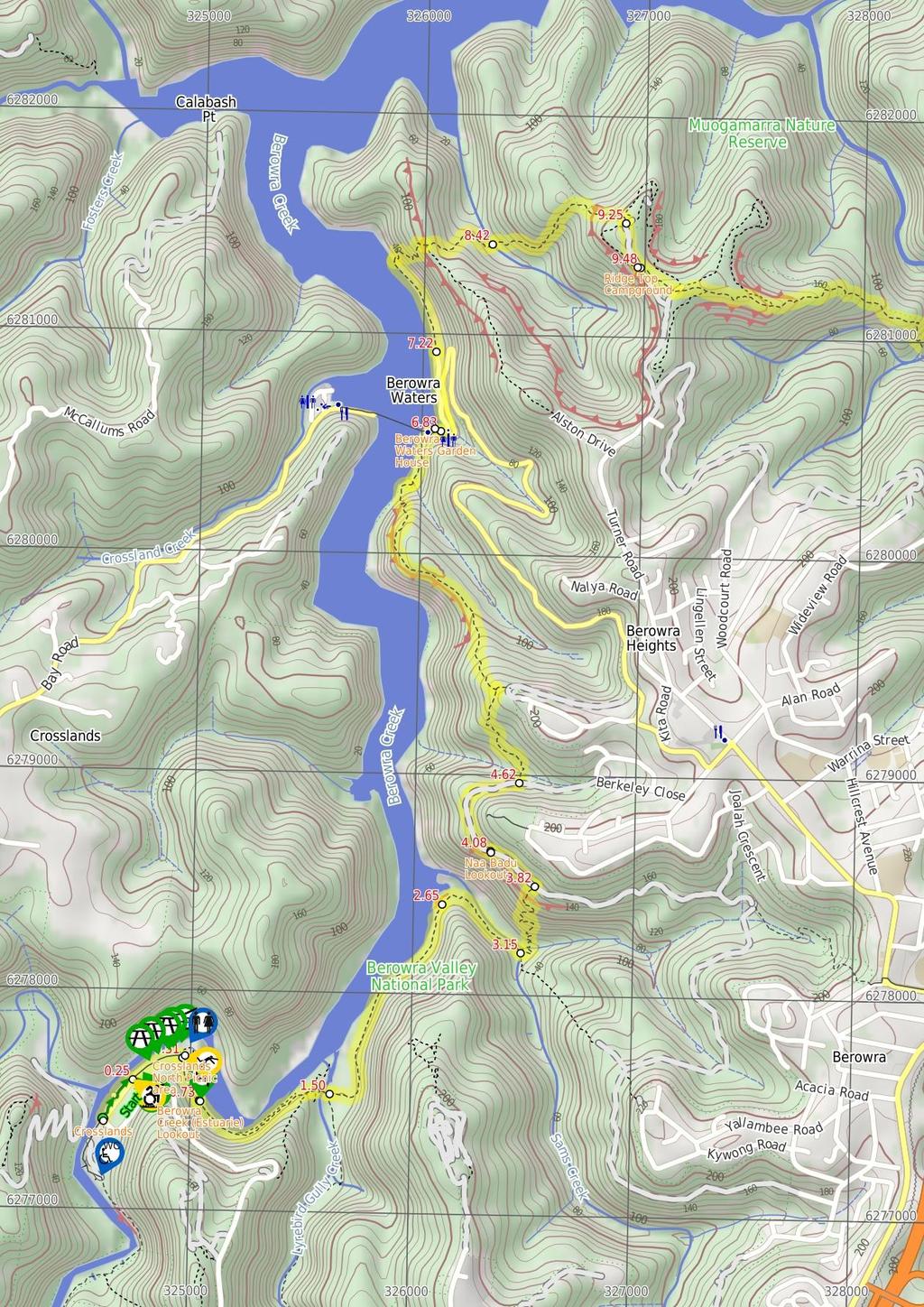
3 Are you ready to have fun? Please ensure you and your group are well prepared and equipped for all possible hazards and delays. Check park closures, weather information and Fire Danger Rating before setting out. Optional side trips and alternate routes noted are not included in this walks overall grade, length or time estimate. Please allow extra time for resting and exploring areas of interest. The authors, staff and owners of wildwalks take care in preparing this information but will not accept responsibility for any inconvenience, loss or injury you may experience. Please take care, have fun - Happy Walking. Getting there Traveling by car is the only practical way to get to Crosslands Carpark (gps: , ). Car: There is free parking available. You can get back from Hawkesbury River Railway Station (gps: , ) by car, train or bus. Car: There is free parking available. The timber boardwalks winds through the mangroves for about 60m, coming to a firm dirt track which leads for another 70m to a second timber boardwalk. The second boardwalk leads for another 70m, past 'Mangrove Food Cycle' information signs to come to an 3-way intersection in the boardwalk with the estuaries viewing platform boardwalk (on your left). Find up to date and more information inlcuding; travel directions, weather, park closures and walker feedback at Estuaries viewing platform (780 m 20 mins) Continue straight: From the intersection at the estuaries viewing platform, this walk follows the timber ramp down to the dirt track and heads past the '..unsuitable for wheelchair access' sign. The track leads alongside the wide creek for about 200m to the 'All creatures great and small' information sign, then down a little way further to head along a short section of timber boardwalk. About 100m further along the rocky track, this walk comes to a lookout and a 'Catch the Threats' information sign, where the track continues past the bench seat and alongside the creek to the 'The Rock Club' information sign. The track then leads among some grass tress for just over 100m to the 'Bush Supermarket' information sign. Just past this sign, the track begins to climb fairly steeply up the stone and timber steps to the ridge line, marked with a GNW arrow and a 'Stop! Look! Listen! and Smell!' information sign. Continue straight: From the ridge line, this walk follows the GNW arrow east downhill, initially keeping the 'Stop! Look! Listen! and Smell!' information sign on your right. The track bends left and follows the timber steps as the track winds steeply down the side of the hill. Near the bottom of the hill, the track passes a 'Rock n Roll' information sign then comes to a long, metal footbridge. The walk crosses the bridge over Calna Creek and comes to a signposted intersection, with a 'Fragile Marsh' information sign 0 Crosslands Crosslands Reserve is lovely and long mixed use picnic area, spanning along the edge of Berowra Creek. There are picnic tables, electric barbecues, toilets, car parking, a children's playground, garbage bins, camping area, toilets and town water. The southern part of Crosslands is managed by Hornsby Council and the northern half by the NPWS within the Berowra Valley National Park. The first inhabitants of this area were a subgroup of the Dharug people who enjoyed the sandstone caves, fish and abundant plant life in the area. It is now managed by Hornsby Shire Council, but in 1856 Matthew Charlton asked Burton Crossland to be caretaker on this area. Burton built a house and made a living by harvesting timber, growing fruit, fishing and boat-building. 0 Crosslands Carpark (250 m ) From the car park, this walk follows the flat dirt path between the road (on the right) and creek (on the left). The path leads through the casuarina trees for about 120m to pass the boat ramp. After another 120m this walk comes to a locked gate at the northern end of the car park. There is also a wetland through the trees to the right worth noticing Northern end of Crosslands Carpark (260 m ) Continue straight: From the northern end of Crosslands car park (at the far northern end of Somerville Rd, Hornsby Heights), this walk follows the 'Newcastle' arrow on the large 'Great North Walk' sign around the locked gate and along the sealed old road. The walk continues along the old road for just over 150m passing 4 picnic tables to come to a y-intersection. At the intersection this walk veers right, past the 'Place of Winds' sign and wetland (on your right). This walk continues along this old road for a little longer, coming to an intersection marked with a large 'Crosslands' information board and 'Great North walk' sign. This is just on the edge of the northern picnic area, not far from the toilet block Crosslands North Picnic area The northern section of Crosslands is in Berowra Valley NP and is a less formal picnic area compared with the southern area. There is a toilet block and a few sandy beaches with direct access to the water. Here you will find a few picnic tables and shelters, as well as garbage bins. The eastern side is home to a boardwalk exploring the estuarine wetland. A pleasant area to rest and enjoy the water. Fires are only permitted in formally established fire places Crosslands North (220 m ) Turn right: From the intersection at the northern picnic area, this walk follows the 'Great North Walk' sign along the timber boardwalk Berowra Creek (Estuarie) Lookout The Estuarie lookout over Berowara Creek is found at the end of the wheelchair-accessible walk in Crosslands area. The timber lookout platform provides views great views over Berowra Creek, the timber fence is 95cm high. There are also information signs about the local flora and fauna and the 'Original Inhabitants'. There are two timber bench seats encouraging you to take some time to soak up this view Calna Creek Bridge intersection (1.1 km 27 mins) Veer left: From the intersection, this walk follows the 'Berowra Waters' sign along the timber boardwalk. The boardwalk leads for about 80m across the large open flat saltmarsh into the casuarina forest on the other side. Here the track bends left and leads along the side of the saltmarsh for almost 200m, where the rocky track leads a little further before coming alongside Berowra Creek's mangroves. The track continues to gently undulate along the side of Berowra Creek for about 650m among the casuarinas and grass tress, before heading up a fairly short, steep climb. At the top of this climb, the walk comes to a small, flat, pleasant clearing surrounded by large boulders Sams Creek ridge clearing (500 m 11 mins) Continue straight: From the clearing, this walk leads down the north eastern side of this ridge, keeping the main valley to your left. After about 100m this walk comes to another flat saltmarsh, where the track bends right to soon come to a large flat clearing beside Sams Creek (subject to flooding). The track then leads alongside Sams Creek (on your left) for about 350m when, just after climbing over a rock, the track comes to a 'Crosslands' sign pointing back along the track, beside the creek Sams Creek Crossing (670 m 30 mins) Turn left: From the south side of the creek, this walk follows the 'Berowra Waters' sign across the rocky Sams Creek. This creek may become impassable after heavy or prolonged rain. On the other side, the track veers left, crossing a rocky gully and heads up the timber steps. The track now starts to climb steeply, zigzagging up the timber steps and a couple of staircases for just over 300m to find a bench seat in a small sandstone cave. After a rest, this walk continues up more steps (and staircases) for just over 150m, coming to a T-intersection with a wide service trail, where a 'Crosslands' sign points back down the track Int of GNW and Berowra Link tracks (260 m 7 mins) Turn left: From the intersection, this walk follows the 'Berowra Waters' sign gently down along the management trail, keeping the valley to your left. The trail gently undulates along the side of the hill, enjoying some glimpses up to the cliff faces (on the right). After about 180m, the trail crosses a concrete drain, then leads up the hill to find the signposted 'Naa Badu' lookout and its great view Naa Badu Lookout Naa Badu Lookout offers magnificent views south over Berowra Creek as well as over Sams and Calna Creeks. Naa Badu means 'See water' in the Aboriginal tribal language of the Dharug people. It is believed that Berowra Creek was the boundary between the Dharug and Guringai Aboriginal peoples. The lookout is fenced, has a bench seat, picnic table and a fair amount of natural shade Int of Naa Badu Lookout (540 m 11 mins) Continue straight: From the 'Naa Badu' lookout, this walk follows the management trail over the small rise and across the concrete ditch, keeping the valley to your left. The trail leads around the side of the hill for about 300m, gently undulating to come to an intersection with a narrow track and small clearing (on your left, as the trail bends right), just past the large scribbly gum. (This informal track leads down to an unfenced rock platform, with filtered views over Berowra Creek). Continue straight: From the intersection, the walk follows the wide trail gently downhill as it bends right, keeping the valley to your left. After about 140m, the trail narrows a bit, leading down a few short but steeper sections to an intersection (with some steps on your left), where a 'The Great North Walk' sign points back up along the trail Int of GNW and Berkeley Close service trail (2.2 km 1 Hr) Turn left: From the intersection, the walk follows the 'Berowra Waters' sign down the timber steps. The walk then crosses Banggarai Creek using a timber bridge, and leads up some timber steps. The rocky track then leads up some more timbers steps, between two rocks then over a few rocks, where the track then flattens out. The now flat, sandy track winds through the forest for about 150m and passes a timber seat, then leads down across a small gully before the track begins to climb again. The track leads up some more timber steps, then the walk climbs two metal pegs in the rock and continues to climb steeply up the rock and timber steps. After 60m, the track flattens out again, leading gently up through the scribbly gum and angophora forest for just over 100m to a three-way intersection marked with a couple of GNW arrow posts. Turn left : From the intersection, this walk follows the GNW arrow post north-west down the sandy track, directly towards the valley. The track soon becomes rocky and leads fairly steeply down the hill for about 150m before mostly flattening out and coming close to the top of an unfenced cliff with good views over Berowra Creek. Here the rocky track continues more gently down along the top of the ridge for about 200m and comes to a large rock platform. This walk veers right to lead down the gap in the rock, climbing down some steel pegs to where the track flattens out again. The track leads across the saddle for about 60m then veers left and follows along the base of a long rock wall (on your right). Here the track leads down around the side of the ridge for just over 400m, passing some unfenced views for rock platforms
4 then down some sandstone steps to find a tall sandstone overhang with a timber seat. From this cave, this walk continues along the base of the rock wall, and soon bends left and winds fairly steeply down a series of rock and timber steps to come to the edge of Berowra Creek (where there is a 'no wash' sign facing the water from the rock platform). The track leads along the shore line for a short time to head onto the rock platform in Washtub Gully. Continue straight: From Washtub Gully, this walk crosses the creek and follows the track, keeping Berowra Creek not far to your left. After about 50m, the track passes an old partially sunken boat, then about 100m further on, the track passes a view point that is an obviously popular (but not recommended) jumping spot. The track then soon leads up some steps and over a rise behind the 'Berowra Waters Garden House' restaurant, then heads down the steps to come to the signposted 'Berowra Waters Trackhead' on 'Berowra Waters Rd' Berowra Waters Garden House #######CLOSED###### This picturesque little restaurant sits on the eastern side of Berowra Creek and is just a hop, skip and a jump from the ferry. With breakfast, lunch and dinner menus, the Garden House Restaurant is a great spot for those looking to tap into the Berowra Valley's full potential. For information on bookings and opening hours phone (02) Berowra Waters track head (390 m 8 mins) Continue straight: From 'Berowra Waters Trackhead', this walk follows the 'Newcastle' sign along 'Kirkpatrick Way' and across the culverted Franks Gully creek. As the walk crosses the gully, there is a picnic area and public toilet (and tap water) on your right. The walk continues along the road, keeping the water to your left for about 180m, then passing under the yellow boom gate. About 30m later, the walk stays left to head alongside the fenced car park. At the far end of this car park, the walk comes to a turning area at the end of Kirkpatrick Way End of Kirkpatrick Way (1.2 km 35 mins) Continue straight: From the end of Kirkpatrick Way, this walk follows the GNW arrow post along the track, keeping the water just to your left. This walk follows the rocky shoreline, enjoying the views of the water, the boats and houses on the other shore and the large rocks (up to your right). After about 450m, the track passes a large boulder and then turns right and climbs up a staircase, finding a small seat and viewing platform. Veer right: From the seat and view, this walk follows the 'Cowan' sign steeply uphill, following the series of timber and rock steps. After about 50m, the track leads up beside a rock wall, and at the top, turns right and mostly flattens out for about 80m before starting to climb again. At the top of this hill, this walk comes to a small clearing (on the left, that has been used as a campsite) and a large unfenced rock platform with great views back over the valley (on your right). Continue straight: From the view at the top of the ridge, this walk follows GNW arrow post east, directly away from the Berowra Water views and over the small rise. The track soon leads down off a rock, where the track bends right and starts to lead fairly gently downhill. The track then leads down a few short, steep, rocky sections before crossing a lovely creek, flowing over the sandstone rock platform. This creek may be slippery and can be particularly risky to cross after rain Deep Bay Creek crossing (840 m 32 mins) Continue straight: From beside the creek, this walk follows the GNW arrow post east, away from the creek, up the steep rocky hill. The track soon passes between two rock slabs, then passes a handrail to climb up two metal pegs beside some more hand railing. The track then continues to climb up for another 50m before mostly flattening out for about 150m. the track then starts to climb again and soon steps up a rock with two more metal pegs. Then after another 70m, the track climbs up past a sandstone cave and heads up a crack in the rock with four metal pegs, then just past the next cave, goes up another rock with a single peg. A short time later, this walk leads up another rock with two pegs, where the track then leads up the steps through a cleft of a rock. Here the track mostly flattens out and leads gently uphill for almost 200m until crossing a small saddle, marked with a two GNW arrow post beside each other. The track then leads steeply up to a fair sized rock platform, with rewarding views back over Berowra Creek (on your left). From this view point, the track leads fairly gently uphill for almost 150m, coming to a T-intersection with a wide sandy management trail Int of GNW and Coreen Close service trail (220 m ) Veer right: From the intersection, this walk follows the GNW arrow along the sandy management trail, heading south. The trail immediately bends left and passes a track (on your right, that runs generally parallel to this trail). This trail leads down through the scribbly gum and heath forest, where the trail widens (after about 70m) and then comes to an intersection beside the large ridge top campsite. There is a 'Berowra Waters' sign here, pointing back along the trail Ridge Top Campground About 800m from Turners Rd, Berowra Heights lies this pleasant ridge top campsite. This is a fairly popular campsite on the Great North Walk, providing a flat area with plenty of shade. There are no facilities (or water) at this large campsite. A faint track leads west from the campsite to an unfenced cliff with great views over the Berowra Waters Valley End of day 1 This is the planned overnight stay for the end of day 1, happy camping.
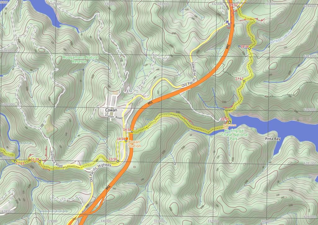
5 9.49 Int of ridge top campsite and GNW (1.7 km 37 mins) Veer left: From the intersection, this walk follows the 'Cowan Station' sign, directly away from the campsite along the clear track. The track leads over a small rise and then heads down to a four-way intersection with a management trail (and the GNW track continuing ahead). Continue straight: From the intersection, this walk follows the GNW arrow post east along the track as it leads very gently downhill along the top of the ridge. Over the next 300m, the track passes a rock platform and comes to a second rock platform with more views and a 'Great North Walk' log book box on a post. After leaving your note (and reading through a few entries), this walk continues down along the top of the ridge for another 200m to step down off another rock platform (ignoring the track to your left). Here the walk starts to head downhill for the next 1km - initially the track leads down a series of short rocky steep sections, and passes some interesting large rock boulders along the way. As the track moves further into the valley, it becomes consistently steeper until leading down leading into the ferns and beside Joe Crafts Creek Joe Crafts Creek crossing (660 m 26 mins) Continue straight: From the western bank, this walk crosses Joe Crafts Creek and heads east up the clear track. This creek may be particularly dangerous to cross after heavy or prolonged rain. The track climbs up a series of stone steps, passing through a couple of cracks in the rock before a 'Great North Walk' sign about 60m from the creek. The rocky track continues to climb steeply up for about 300m, then climbs up a timber (and metal) staircase, followed by a few section of handrail. Here the walk leads up around the base of rock wall and then climbs up the side to the top of the large, unfenced rock platform with great valley views. The walk continues up the ridge line for another 200m, very gently at first, then more steeply up the rocky sections. The track heads along the base of another rock wall, then up the stone steps and past the handrail to come to an intersection marked with a 'Great North Walk - Viewing Area' sign. The short track (on your right) leads to a seat at the edge of an unfenced cliff with views and a seat Valley viewing area (1.7 km 35 mins) Turn left: From the intersection near the 'viewing point', this walk heads gently uphill directly away from the viewing area, keeping the valley on your right. The track leads up a few short, moderately steep sections for about 100m, then the track heads much more gently up through the open scribbly gum forest for about 400m before passing under the power lines. Here, the walk turns left and follows the wide trail for about 40m and turns right (before the locked gate), following a GNW arrow post under another set of power lines. The walk follows the track through the pleasant forest for just shy of 300m then crosses the dirt Glendale Rd to find 'Berowra Waters' sign pointing back across the intersection. Continue straight: From the intersection, this walk follows the 'Cowan' sign away from the dirt road and down along the rocky and sandy track. The track winds through the forest (with some interesting twisted, thin scribbly gums) for about 600m before bending left and following under a set of power lines. Near the Pacific Hwy (up to your right), this walk continues for about 150m and crosses over a very short section of timber boardwalk before climbing up a few steps to a T-intersection with a wide management trail Int of GNW and Pacific Highway service trail (500 m 11 mins) Veer left: From the intersection, this walk follows the GNW arrow post gently downhill, keeping the valley views to your left. The trail gently winds behind some houses (up to your right) for about 400m before bending right and heading up through a weedy section. The walk then passes around a locked gate to come to an intersection with a footpath, just before the Pacific Hwy and across from Cowan station. There is a large 'Great North Walk' sign here, pointing back to 'Sydney Cove' Int of GNW and Pacific Highway service trail (40 m 1 mins) Continue straight: From the intersection, this walk follows the Great North Walk arrow across the Pacific Highway (be careful of traffic) to the ramp at the front of Cowan Railway Station Cowan Station (300 m 6 mins) Continue straight: From the front of Cowan station, this walk follows the GNW arrow up the concrete ramp, turning right to cross the track at the controlled 'Pedestrian Railway Crossing'. The walk follows the ramp onto platform 1 (Sydney-bound side) then around the shelter to follow the GNW arrow post right, down the steps and through the gate. Here the walk crosses the train lines (train storage area) and turns left, following the 'Brooklyn' sign along the wide management trail. After 130m, the trail leads past an electrical switching area then turns right at the large 'Great North Walk' signposts. Here, the narrower trail leads between the fences over a small rise to cross the freeway on a large, fenced concrete bridge Freeway Bridge (2.2 km 50 mins) Continue straight: From the overpass, this walk heads away from the freeway and down the wide track. The track leads down a series of timber steps, then over a small rise (among the scribbly gums) where the track begins to narrow and lead more steeply down a rocky section. The walk then heads down a series of timber steps (passing a 'Great North Walk' sign), and crosses a short section of timber boardwalk. At the other end of the boardwalk, this track leads left over a rock platform (with a small creek flowing after rain) and then turns right to step off the rock platform. Continue straight: From the intersection, this walk heads downhill along the rocky track. The track leads past a few rock walls over about 350m, then turns right onto, then steps down off, a long thin rock platform. The track continues down along the side of the valley for another 200m, passing into a much more lush and dense forest, where the track then crosses the creek at a large rock platform. On the other side of the creek, the track leads right down along the other side of the valley, passing a few small sandstone overhangs then a particularly broad angophora tree after about 500m. Soon after this angophora, the track leads down some rock steps then begins to widen for about 300m, and passes a small track (on your right) marked with a 'No Camping or fires allowed' sign. By this point, the broad waters (or mud flats, depending on the tide) of Cowan Creek are obvious, on your right. The walk now continues along the generally broad and flat track for another 500m, then climbs up a set of concrete steps, marked with a GNW arrow post. At the top of these steps is a large, fairly flat clearing with a 'No Camping' and a 'Great North Walk' sign and a great view up the middle of Jerusalem Bay Jerusalem Bay Jerusalem Bay, Ku-ring-gai National Park, is a nice bay east of Cowan Station. The bay is popular with bushwalkers as it is part of the Great North Walk. The bay is sometimes known for an iconic photo of the single palm in front of the water. The bay itself is also popular with boaters who can anchor in the bay. Jerusalem Bay can be accessed by the Hawkesbury River and Broken Bay or from Brooklyn or Cowan Railway Stations Jerusalem Bay (1.1 km 37 mins) Continue straight: From the clearing at Jerusalem Bay, this walk follows the 'Great North Walk' sign, keeping the water to your right. The track bends left then leads down some sandstone steps (with a handrail). The track soon becomes fairly rough and follows the shoreline for about 200m before crossing a rocky and mossy gully. On the other side of this gully, the track tends right, following the GNW arrow post past a sandstone overhang, and over a small flat timber bridge. Just past this bridge, the track bends left and starts to climb steeply up the particularly rocky track. After about 300m of climbing, the track passes a small clearing with a small seat (on your right). Over the next 400m, the rocky track still heads up, but is generally less steep. The walk then comes to a large rock outcrop, where the track turns right to head up through a rocky gully. About 60m after this climb, the track leads up another short climb to a rock platform, then a third consecutive climb leads up through a crack in a rock to find a much welcomed bench seat and 'Great North Walk - Track Register' log book box. From here, the walk follows the the track gently uphill for another 60m to a 'Jerusalem Bay' sign pointing back along the track, at the top of the ridge Ridge Top (760 m 18 mins) Continue straight: From the top of the ridge, this walk follows the 'Brooklyn Dam' sign, gently uphill, heading north through the tall heath. The mostly flat track leads through the forest, with an occasional glimpse to the freeway and down to Brooklyn. after about 400m, the track bends left and leads through a long cleft in the rock. Here the track start to head more and more steeply down for the next 350m, until heading down some timber steps which lead to Campbells Creek. The walk steps over the small (orange, polluted ) creek to find a flat sandy clearing a few metres past the creek Campbells Ck (1.2 km 3) Continue straight: From the small clearing, this walk follows the clear track away from the creek, and soon bends left then begins to climb. The rocky track climbs steeply for about 200m, passing among the grass trees and eucalyptus. The track flattens out and passes alongside a rock wall, then resumes the climb up the hill. At the top of this climb, the track passes a couple of small rock overhangs then climbs about halfway up a section of rock to follow the longer section of rock platform to the right. The track then gently undulates along the side of the hill, passing a section of hand rail after about 70m. The track then follows a series of small rock walls (on your left) for about 250m before climbing up onto a flat, sandy track. This soon leads to a faint intersection (with a track on your right, which goes to a large rock platform). From here, the sandy track stays mostly flat for about 300m before veering left at a GNW arrow post, leading up a more rocky section of track and then climbing up some steel pegs in the rock wall at the next GNW arrow post. Here the track leads up the short hill and comes to a T-intersection with a wide management trail, where a 'Jerusalem Bay' sign points back down the hill Int. Jerusalem Bay Trk and Brooklyn Dam Service Tr (4.1 km 1 hr 25 mins) Turn right: From the intersection, this walk follows the 'Brooklyn' sign down along the wide management trail, initially keeping the power lines to your right. The trail gently undulates along the top of the ridge for about 700m, passing a few short side tracks (which lead to the power poles) and distant valley glimpses. The trail leads over a solid rock platform and less than 100m later, the walk leads past a track (on your right, which leads to a unfenced view over the valleys, from the power pole). The walk continues along the main trail for another 90m then follows a GNW arrow post as the trail bends left, then right, to head downhill notably steeply for a short time. The trail then continues to undulate along the top of the ridge for about 1.2km, passing more side tracks to power poles (some with unfenced views). The walk then comes to a point where the trail bends sharply right, and there is a filtered view over the Hawkesbury River to Peats Ferry Bridge. From here, the walk heads quiet steeply down for about 400m to pass under some power lines, where the trail then bends sharply left (enjoying some filtered views down to Brooklyn Dam and the Hawkesbury, on your right), passing under then same power lines again. The trail soon flattens out, coming to a faint three-way intersection (with a re-vegetating track on your

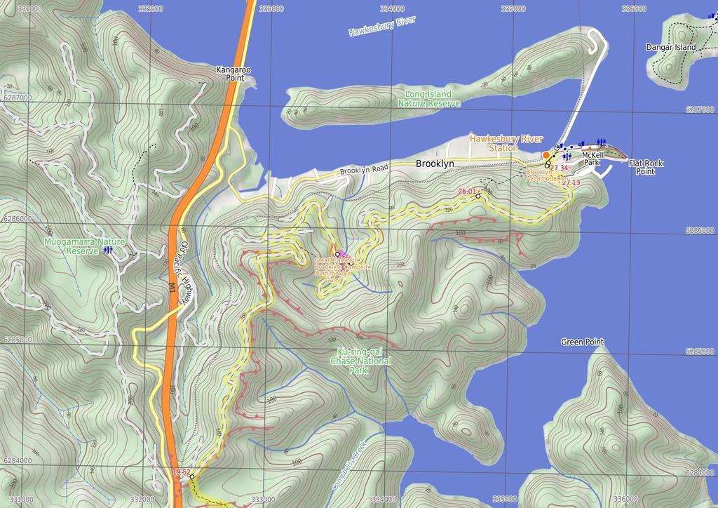
6 right), marked with a 'Great North Walk' sign. Continue straight: From the intersection, this walk follows the 'Great North Walk' sign along the wide management trail as it initially leads over a small rise then heads downhill, keeping the valley to your right. After about 300m, the trail turns sharp right at the T-intersection with another wide trail. This flat wide trail follows the power lines for about 250m to then veer left (at the Yintersection), heading downhill away from the power lines. The trail leads downhill for just shy of 300m, passing the speed hump signs to then bend right at the large clearing (ignoring the fenced trail on your left). Then about 100m later, this walk ignores another fenced trail (on your left) as this trail is still bending right. Here the trail heads around the side of the hill for 400m to come to an intersection with a track (on your left, leading a few meters to the signposted campsite) marked with a GNW arrow post Small Campsite Brooklyn Dam The small campsite next to Brooklyn Dam, Ku-ring-gai Chase National Park, is a small grassy campsite which has room for approximately four sites. The close proximity to Brooklyn Dam means close water. The campsite also has a few tall shady trees and is a fuel-stove only site Alternate Route NW Brooklyn Dam Campsite to NE Bro (180 m ) Turn left: From this intersection, this walk follows the track east, away from the main trail and through the small 'Brooklyn Dam' campsite. On the other side of the campsite, the narrow track bends right and leads down into the gully, down a few concrete steps then heading alongside the small creek. Just before the dam wall, the track bends left, across the creek and up the short rocky hill to find a larger clearing. There is a good view over the dam (on your right). The track continues bending right through the clearing, and up a short hill to an intersection with the wide trail. Now Turn left to rejoin the main walk NW Brooklyn Dam Campsite intersection (790 m 15 mins) Continue straight: From the intersection, this walk follows the GNW arrows post south along the wide trail, soon passing alongside the dam (on your left). About 40m after passing edge of the dam wall, this walk comes to an intersection with a re-vegetating track (on your right) and a large 'Ku-ring-gai Chase National Park - Brooklyn Dam' sign (on your left). Continue straight: From the intersection, this walk follows the GNW arrow post along the wide trail, keeping the dam to your left. (This section of trail leads around to the far side of the dam.) After just over 250m, the trail crosses a small creek (at the apex of the dam) then continues bending left. The track passes some old concrete pipes (on your left) then after about 400m, the trail comes to an intersection with a clearing and dam wall (to your left) Large Campsite Brooklyn Dam The large campsite next to Brooklyn Dam, Ku-ring-gai Chase National Park, is a spacious and well-maintained campsite which has room for plenty of tents. The close proximity to the dam means accessible water (treat before drinking). The campsite has many tall, shady trees and is a fuel stove only site. The concrete dam wall was built in 1884 to provide water for the steam trains passing about 500m to the north. The dam was enlarged six times before 1924, then in in 1989 the dam was added to the expanded Ku-ring-gai Chase National Park NE Brooklyn Dam Campsite (1.6 km 3) Veer right: From the intersection, this walk follows the GNW arrow post uphill along the management trail, directly away from the dam. After about 30m, the trail bends right and passes a 'Ku-ring-gai Chase National Park - Brooklyn Dam' sign and continues uphill for another 150m, to where the trail becomes less steep (enjoying some filter views over the Hawkesbury on your left) for about 180m. Here a GNW arrow post guides along a short track (on the left), that runs parallel before re-joining the main trail again a short distance later. The walk then continues uphill to veer right at a three-way intersection, under the power lines, then about 120m later, this walk veers right again at another three-way intersection. About 70m up from here, the walk veers left at another three-way intersection, this time the trail generally follows the power lines along the side of the ridge. After another 300m, the trail bends right and passes under a set of high tension power lines, then continues to gently undulate for another 600m to come to a three-way intersection (with a clearing and trail on your left) and a 'Cowan' sign pointing back along the trail Int of Hawkesbury Track and Brooklyn Trail (1.1 km 25 mins) Continue straight: From the intersection, this walk follows the 'Brooklyn Station' sign gently downhill along the management trail, keeping the Hawkesbury River glimpses to your left. The trail gently undulates for about 600m before bending left to find a large clearing and water glimpses. From the clearing, the trail starts to lead downhill towards the water, and after nearly 100m, the trail leads steeply down a short section of concreted trail. Just after this, the trail leads steeply again over a longer section of concrete, where the trail then leads through a rock cutting to find an even longer and steeper section of concrete trail. This section of concrete leads down for about 220m, sweeping left to head around a locked gate, past a large 'Great North Walk' sign to find the southern end of William St. Here the walk turns right to head down William St then across George St to find a few 'Great North Walk' signs on the corner Int of George & William Sts (200 m ) Turn left: From the intersection, this walk follows the 'Great North Walk - Direct Route' sign gently uphill along the footpath beside George St. At the top of this hill, the walk turns right onto 'Bridge St' and heads down past a cafe, post office and 'The Anglers Rest' (on the other side of the road) and crosses 'Brooklyn Rd' to find a phone box on the other side Brooklyn Accomodation Brooklyn is a lovely little village with plenty of holiday style accommodation. There are several small cafe/restaurants in the area, good choice for cooked meals. There are two options for overnight visits, both need to be booked in advance. Brooklyn Motel: Newly renovated accommodation on Bridge St,nearly opposite The Anglers Rest. This studio style accommodation starts from $120 per night with a spa, television and free wifi. Ph: or Breakfast can be organised for an extra fee. The Anglers Rest: Pub style accommodation on the intersection of Brooklyn & Dangar Rds. There are shared bathroom facilities. From $60 single and $90 a double. Breakfast not included (but you can grab breakfast from a cafe) PH:(02) Int of Brooklyn AND Dangar Rds (90 m 1 mins) Continue straight: From the intersection, this walk follows the footpath down along Dangar Road past the phone box, keeping the train line and road to your left. The path soon leads past the community centre then the blue painted 'JJs Brooklyn' fish and chip store to come to the sandstone 'Obelisk' commemorating the naming of the Hawkesbury River. This is just on the other side of the road, opposite some large 'Great North Walk' signs and the Hawkesbury River Railway Station.
7
8
9
10 Summary navigation sheet for the Crosslands to Brooklyn km From Up/Dwn Length Initial directions (Use full tracknotes and maps for more detail) Start Crosslands Carpark , (GR Hornsby, ) 0.25 Northern end of Crosslands Carpark , (GR Hornsby, ) 0.51 Crosslands North , (GR Hornsby, ) 0.73 Estuaries viewing platform , (GR Hornsby, ) 1.51 Calna Creek Bridge intersection , (GR Hornsby, ) 2.66 Sams Creek ridge clearing , (GR Cowan, ) 3.16 Sams Creek Crossing , (GR Cowan, ) 3.83 Int of Great North Walk and Berowra Link tracks , (GR Cowan, ) 4.09 Int of Naa Badu Lookout , (GR Cowan, ) 4.63 Int of Great North Walk and Berkeley Close service trail , (GR Cowan, ) m 260 m 220 m 780 m 20 mins 1.1 km 27 mins 500 m 11 mins 670 m 30 mins 260 m 7 mins 540 m 11 mins 2.2 km 1 Hr From the car park, this walk follows the flat dirt path between the road (on the right) and creek (on the left) m 8 mins 1.2 km 35 mins 840 m 32 mins 220 m 0m Continue straight: From 'Berowra Waters Trackhead', this walk follows the 'Newcastle' sign along 'Kirkpatrick Way' and across the culverted Franks Gully creek. Continue straight: From the end of Kirkpatrick Way, this walk follows the GNW arrow post along the track, keeping the water just to your left. Continue straight: From beside the creek, this walk follows the GNW arrow post east, away from the creek, up the steep rocky hill. Veer right: From the intersection, this walk follows the GNW arrow along the sandy management trail, heading south. This is the planned overnight stay for the end of day 1, happy camping. 1.7 km 37 mins 660 m 26 mins 1.7 km 35 mins 500 m 11 mins Veer left: From the intersection, this walk follows the 'Cowan Station' sign, directly away from the campsite along the clear track. Continue straight: From the western bank, this walk crosses Joe Crafts Creek and heads east up the clear track. Berowra Waters track head , (GR Cowan, ) 7.22 End of Kirkpatrick Way , (GR Cowan, ) 8.43 Deep Bay Creek crossing , (GR Cowan, ) 9.26 Int of GNW and Coreen Close service trail , (GR Cowan, ) 9.49 End of day , (GR Cowan, ) 9.49 Int of ridge top campsite and Great North Walk , (GR Cowan, ) Joe Crafts Creek crossing , (GR Cowan, ) Valley viewing area , (GR Cowan, ) Int of GNW and Pacific Highway service trail , (GR Cowan, ) Continue straight: From the northern end of Crosslands car park (at the far northern end of Somerville Rd, Hornsby Heights), this walk follows the 'Newcastle' arrow on the large 'Great North Walk' sign around the lo... Turn right: From the intersection at the northern picnic area, this walk follows the 'Great North Walk' sign along the timber boardwalk. Continue straight: From the intersection at the estuaries viewing platform, this walk follows the timber ramp down to the dirt track and heads past the '..unsuitable for wheelchair access' sign. Veer left: From the intersection, this walk follows the 'Berowra Waters' sign along the timber boardwalk. Continue straight: From the clearing, this walk leads down the north eastern side of this ridge, keeping the main valley to your left. Turn left: From the south side of the creek, this walk follows the 'Berowra Waters' sign across the rocky Sams Creek. Turn left: From the intersection, this walk follows the 'Berowra Waters' sign gently down along the management trail, keeping the valley to your left. Continue straight: From the 'Naa Badu' lookout, this walk follows the management trail over the small rise and across the concrete ditch, keeping the valley to your left. Turn left: From the intersection, the walk follows the 'Berowra Waters' sign down the timber steps. Turn left: From the intersection near the 'viewing point', this walk heads gently uphill directly away from the viewing area, keeping the valley on your right. Veer left: From the intersection, this walk follows the GNW arrow post gently downhill, keeping the valley views to your left.
11 Summary navigation sheet for the Crosslands to Brooklyn km From Int of Great North Walk and Pacific Highway service trail , (GR Cowan, ) Powered by TCPDF ( Up/Dwn Length Initial directions (Use full tracknotes and maps for more detail) m 1 mins Cowan Station , (GR Cowan, ) Freeway Bridge , (GR Cowan, ) Jerusalem Bay , (GR Cowan, ) Ridge Top , (GR Cowan, ) Campbells Ck , (GR Cowan, ) Int. Jerusalem Bay Trk and Brooklyn Dam Service Trail , (GR Cowan, ) m 6 mins 2.2 km 50 mins 1.1 km 37 mins 760 m 18 mins 1.2 km km 1 hr 25 mins NW Brooklyn Dam Campsite , (GR Cowan, ) NW Brooklyn Dam Campsite intersection , (GR Cowan, ) NE Brooklyn Dam Campsite , (GR Cowan, ) Int of Hawkesbury Track and Brooklyn Trail , (GR Cowan, ) Int of George & William Sts , (GR Cowan, ) Int of Brooklyn AND Dangar Rds , (GR Cowan, ) m 790 m 15 mins 1.6 km km 25 mins 200 m 90 m 1 mins Continue straight: From the intersection, this walk follows the Great North Walk arrow across the Pacific Highway (be careful of traffic) to the ramp at the front of Cowan Railway Station. Continue straight: From the front of Cowan station, this walk follows the GNW arrow up the concrete ramp, turning right to cross the track at the controlled 'Pedestrian Railway Crossing'. Continue straight: From the overpass, this walk heads away from the freeway and down the wide track. Continue straight: From the clearing at Jerusalem Bay, this walk follows the 'Great North Walk' sign, keeping the water to your right. Continue straight: From the top of the ridge, this walk follows the 'Brooklyn Dam' sign, gently uphill, heading north through the tall heath. Continue straight: From the small clearing, this walk follows the clear track away from the creek, and soon bends left then begins to climb. Turn right: From the intersection, this walk follows the 'Brooklyn' sign down along the wide management trail, initially keeping the power lines to your right. Alternate Route NW Brooklyn Dam Campsite. Turn left: From this intersection, this walk follows the track east, away from the main trail and through the small 'Brooklyn Dam' campsite. Continue straight: From the intersection, this walk follows the GNW arrows post south along the wide trail, soon passing alongside the dam (on your left). Veer right: From the intersection, this walk follows the GNW arrow post uphill along the management trail, directly away from the dam. Continue straight: From the intersection, this walk follows the 'Brooklyn Station' sign gently downhill along the management trail, keeping the Hawkesbury River glimpses to your left. Turn left: From the intersection, this walk follows the 'Great North Walk - Direct Route' sign gently uphill along the footpath beside George St. Continue straight: From the intersection, this walk follows the footpath down along Dangar Road past the phone box, keeping the train line and road to your left.
Crosslands to Cowan. 220m
 Crosslands to Cowan 7 hrs 30 mins 14 km One way Hard track 4 1103m This section of the Great North Walk starts from the Crosslands camping area and winds north alongside Berowra creek, passing through
Crosslands to Berowra Waters return
 Crosslands to Berowra Waters return 6 hrs Hard track 13.7 km Return 4 1005m This return walk starts from the Crosslands Reserve and follows the Great North Walk along Berowra creek. The walk includes some
Jerusalem Bay Track (Cowan to Brooklyn)
") Jerusalem Bay Track (Cowan to Brooklyn) 5 hrs 30 mins 13.4 km One way Hard track 4 654m This Cowan to Brooklyn Station walk is a popular section of the Great North Walk, with scenery ranging from foreshore
Jerusalem Bay Track (Cowan to Brooklyn) 5 hrs 30 mins 13.4 km One way Hard track 4 654m This Cowan to Brooklyn Station walk is a popular section of the Great North Walk, with scenery ranging from foreshore
Berowra Waters to Cowan Station
 Berowra Waters to Cowan Station 3 hrs 30 mins 7.2 km One way Hard track 597m This is a hilly walk out of the beautiful Berowra Waters valley to Cowan Station. There are many wide views across Berowra Creek
Berowra to Cowan via Berowra Waters
 Berowra to Cowan via Berowra Waters 6 hrs Hard track 12.9 km One way 4 884m With train station at each end this walk explores the ridges and valleys around Berowra Waters. There are plenty of excellent
Mt Kuring-gai Track to Berowra station
 Mt Kuring-gai Track to Berowra station 4 hrs 15 mins 9.7 km One way Hard track 4 553m This walk explores three valleys, with great displays of wild flowers in spring, and some nice sandstone overhangs.
Congewai Track Head (East) to Watagan Headquarters
 to Watagan Headquarters") Congewai Track Head (East) to Watagan Headquarters 7 hrs Hard track 17.2 km One way 4 973m This full day walk starts from the Congewai valley trackhead (east) and follows the Great North Walk up into the
Congewai Track Head (East) to Watagan Headquarters 7 hrs Hard track 17.2 km One way 4 973m This full day walk starts from the Congewai valley trackhead (east) and follows the Great North Walk up into the
Girrakool to Wondabyne station
 Girrakool to Wondabyne station 4 hrs Hard track 9.5 km One way 4 438m This walk starts from the Girrakool picnic area and winds south, through the Brisbane Waters National Park. The walk crosses some long
Berowra to Hornsby. 9 hrs 18 mins 22.6 km One way. Hard track. 1423m
 Berowra to Hornsby 9 hrs 18 mins 22.6 km One way Hard track 4 1423m One of the longer day walks in Berowra Valley National Park, this walk mostly follows Berowra Creek along the Great North Walk. Excellent
Leura Cascades to Gordon Falls Reserve
 Leura Cascades to Gordon Falls Reserve 1 hr 15 mins 1.8 km One way Moderate track 200m From Leura Park to Gordon Falls Park, this diverse walk offers fantastic views of the Jamison Valley, as well as two
Victoria Falls Lookout to Blue Gum Forest
 Victoria Falls Lookout to Blue Gum Forest 8 hrs Experienced only 13.8 km One way 5 112m This long day-walk follows a remote track down from Victoria Falls lookout, passing the waterfall, and into the Grose
Staples Lookout to Mt Wondabyne loop
 Staples Lookout to Mt Wondabyne loop 4 hrs 3 mins 1.8 km Circuit Hard track 337m This walk starts and finishes at Staples Lookout, on Woy Woy Rd. The walk follows sections of the Great North Walk around
Nature Track. 900m. 789m. 2 hrs 3.1 km Circuit. Hard track 238m. Blue Mountains National Park
 Nature Track 2 hrs 3.1 km Circuit Hard track 238m Largely following the ridges around the top edge of Wentworth Falls, this track is incredibly beautiful. After taking in the great views at Edinburgh Castle
Erskine Creek via Pisgah Rock and Jack Evans
 Erskine Creek via Pisgah Rock and Jack Evans 4 hrs 30 mins 7.1 km Circuit Very experienced only 6 421m This walk visits some great lookouts and explores the lower section of Erskine Creek. Most of the
Merritts Traverse. 1928m
 Merritts Traverse 3 hrs Hard track 5.8 km Circuit 4 167m This walk starts with a scenic journey to the top of the hill on the chairlift. Starting along Merritts Nature walk, this walk soon detours down
Cowan to Wondabyne station via Patonga rest area
 Cowan to Wondabyne station via Patonga rest area 2 Days Hard track 33.4 km One way 4 1523m This section of the Great North Walk starts from Cowan train station and wanders past the majestic Jerusalem Bay
Hornsby station to Crosslands
 Hornsby station to Crosslands 6 hrs 45 mins 16.1 km One way Hard track 4 938m This section of the Great North Walk starts from Hornsby train station and winds down along the Blue Gum Walk into Fishponds.
Gibberagong Track. 169m
 Gibberagong Track 2 hrs 30 mins 6.5 km One way Hard track 4 180m Starting in suburban Wahroonga, this wellmaintained track follows Cockle Creek down to Bobbin Head in the Ku-ring-gai Chase National Park.
Abbotts Falls Walking Track
 Abbotts Falls Walking Track 3 hrs 7.3 km Circuit Hard track 329m This circuit takes you through both dry and moist forest, using a combination of walking trails and wider tracks. The side trip to the dammed
Girrakool to Wondabyne station via Pindar caves
 Girrakool to Wondabyne station via Pindar caves 7 hrs 30 mins 18.1 km One way Experienced only 5 741m This walk starts from the Girrakool picnic area and winds south, following Piles creek into the Brisbane
Thornleigh to Cowan. 2 Days. Hard track 35.9 km One way. 2337m
 Thornleigh to Cowan 2 Days Hard track 35.9 km One way 4 2337m Following the Great North Walk and Berowra Creek through Berowra Valley Regional Park, this walk cuts straight through the length of the Park.
Guthega to Mt Twynam. 2183m. 1583m. 6 hrs 45 mins 14.8 km Return. Experienced only. 913m
 Guthega to Mt Twynam 6 hrs 45 mins 14.8 km Return Experienced only 5 913m This walk starts from Guthega and makes its way along the Snowy River to the Illawong Lodge, via the Blue Cow Creek flying fox.
Patonga to Staples Lookout
 Patonga to Staples Lookout 6 hrs 3 mins 17 km One way Hard track 4 72m This great walk explores much of the main ridge ridge running through Brisbane Water National Park. The walk visits a number of great
Scenic Railway to Ruined Castle
 Scenic Railway to Ruined Castle 7 hrs 30 mins 12.4 km Return Hard track 4 963m This is a very popular, full day walk, in the Katoomba Area, offering great views of the valley. The walk follows the edge
National Pass. 893m. 665m. 3 hrs 30 mins 4.6 km Circuit. Hard track 773m. Blue Mountains National Park
 National Pass 3 hrs 3 mins 4.6 km Circuit Hard track 773m 4 This walk offers fantastic views of the Jamison Valley and the surrounding cliffs. Take time to explore the historic and very scenic ledge halfway
Wondabyne station to Somersby Store
 Wondabyne station to Somersby Store 10 hrs Hard track 26.2 km One way 4 1164m This walk, following a section of the Great North Walk, starts from the Wondabyne train station and winds north, into the Brisbane
Dadder Cave and Jack Evans track
 Dadder Cave and Jack Evans track 2 Days 10.3 km Circuit Very experienced only 535m This fairly short overnight walk is a great way to explore Erskine Creek. The walking along Erskine creek is mostly off
Wentworth Pass. 893m. 535m. 4 hrs. Hard track 5.1 km Circuit. 692m
 Wentworth Pass 4 hrs Hard track 5.1 km Circuit 4 692m This walk offers a great way to explore the magical, upper section of the Valley of the Waters. The walk starts and finishes at Conservation Hut, which
Patonga to Wondabyne station via Mt Wondabyne
 Patonga to Wondabyne station via Mt Wondabyne 7 hrs 3 mins 19.5 km One way Hard track 4 861m This walk explores some grand views, pleasant cascades, varied bushland and remote areas of Brisbane Waters
Somersby to Yarramalong via Stringy Bark Point
 Somersby to Yarramalong via Stringy Bark Point 2 Days Hard track 26.7 km One way 4 1201m This section of the Great North Walk starts form the Somersby General Store and follows the Great North Walk north
Victoria Falls to Blackheath Station
 Victoria Falls to Blackheath Station 2 Days Experienced only 22.2 km One way 5 1561m This is a fantastic overnight walk with a sleep in Acacia Flats camping area. The Grose Valley, with its views of the
Victoria Falls and Grose Valley to Blackheath Station
 Victoria Falls and Grose Valley to Blackheath Station 3 Days Experienced only 22.5 km One way 5 158m This walk explores a fantastic section of the Grose Valley. Starting above Victoria Falls, the walk
Patonga to Wondabyne station via Pindar Caves overnight
 Patonga to Wondabyne station via Pindar Caves overnight 2 Days Experienced only 28.1 km One way 5 1164m This overnight hike starts from Patonga beach and winds along a section of the Great North Walk,
Somersby to the Basin Campsite
 Somersby to the Basin Campsite 3 Days Hard track 47.4 km One way 4 2032m This three day walk starts at the Somersby General Store and follows the Great North Walk, heading north, into the the Jilliby State
Lady Carrington Drive
 Lady Carrington Drive 3 hrs 45 mins 9.7 km One way Moderate track 3 266m This walk follows the historic Lady Carrington Drive alongside the Hacking River. The old road is closed to traffic and provides
Blackheath to Blue Gum loop
 Blackheath to Blue Gum loop 2 Days Hard track 24.1 km Circuit 4 1335m This walk is great for fit people getting into overnight walking, with its fantastic scenery and nostalgia as a classic overnighter.
Leura to Katoomba via Dardanelles Pass
 Leura to Katoomba via Dardanelles Pass 4 hrs 6.6 km One way Hard track 697m With approximately equal parts cliff-walk and forest track, this track truly shows what the cliff edges of the Jamison Valley
Main Range Track - Loop from Charlotte Pass camping near Mt Townsend
 Main Range Track - Loop from Charlotte Pass camping near Mt Townsend 2 Days Experienced only 27.7 km Circuit 5 1260m This great overnight walk starts from Charlotte Pass and provides access to some of
Main Range Walk - Charlotte Pass to Mount Kosciuszko
 Main Range Walk - Charlotte Pass to Mount Kosciuszko 9 hrs Hard track 21.9 km Circuit 4 920m This full day walk explores some of the greatest alpine country on offer in NSW. The walk grants views of Blue,
Gordon to Hornsby (overnight at Scout camp)
") Gordon to Hornsby (overnight at Scout camp) 2 Days Hard track 25.8 km One way 4 125m This overnight walk starts from Gordon train station and winds through bush filled valleys to Hornsby station. From
Gordon to Hornsby (overnight at Scout camp) 2 Days Hard track 25.8 km One way 4 125m This overnight walk starts from Gordon train station and winds through bush filled valleys to Hornsby station. From
Victoria Falls and Grose Valley to Blackheath Station
 This walk explores a fantastic section of the Grose Valley. Starting above Victoria Falls, the walk explores the cascades before dropping into the valley for the first nights rest at Burra Korain campsite.
The Prince Henry Cliff Walk
 The Prince Henry Cliff Walk 3 hrs 30 mins 6.8 km One way Moderate track 3 575m Going from Katoomba to Leura, this walk covers the top of the cliff line and most of the major lookouts. With brilliant vistas
Western Commission Track to Dubbo Gully
 This two day walk follows a series of historic roads along clear and wide management trails. This walk explores the great views from Western Commission Track, the sandstone handicraft on the Old Great
COLOUR G U I D E. Sydney to Newcastle: Australia s most accessible long-distance walk
 COLOUR G U I D E Sydney to Newcastle: Australia s most accessible long-distance walk Woodslane Press Pty Ltd Unit 7/5 Vuko Place Warriewood, NSW 2102 Australia Email: info@woodslane.com.au Tel: (02)
Katoomba to Wentworth Falls via the Jamison Valley
 Katoomba to Wentworth Falls via the Jamison Valley 2 Days Experienced only 29.2 km One way 5 2135m This is the two day version of this popular and challenging walk. This walk passes popular sights including
Guthega to Thredbo camping overnight at Wilkensons Creek
 Guthega to Thredbo camping overnight at Wilkensons Creek 2 Days Experienced only 25.8 km One way 5 1364m This great overnight walk explores the Kosciusko National Park between Guthega and Thredbo, visiting
Main Range Circuit from Guthega
 Main Range Circuit from Guthega 4 Days Experienced only 45 km Circuit 5 2317m This four day walk explores the Kosciuszko National Park, covering many of the key features of the park between Guthega and
Out and about at Geehi
 Geehi Geehi Flats is a large area of flat floodplain on the banks of the Swampy Plains River. Located within Kosciuszko National Park, it is home to a popular campsite in summer for people wanting to enjoy
The Mendip Way. Route Directions and Maps Uphill to Wells
 The Mendip Way Route Directions and Maps Uphill to Wells Website: www.mendiphillsaonb.org.uk Email: mendip@mendiphillsaonb.org.uk Facebook & Twitter: @MendipHillsAONB Phone: 01761462338 1 Uphill to Loxton
Hindhead, Keffolds Copse and Gibbet Hill
 point your feet on a new path, Keffolds Copse and Gibbet Hill Distance: 6 km=4 miles Region: Surrey Author: Schwebefuss Refreshments: Punch Bowl Café moderate walking Date written: 14-apr-2015 Last update:
GOLDEN EARS PROVINCIAL PARK
 GOLDEN EARS PROVINCIAL PARK Trail Information as of October 10 th 2015 Do not underestimate the mountainous wilderness of Golden Ears Provincial Park. The combination of rugged terrain and rapidly changing
Leaden Boot Challenge ROUTE INSTRUCTIONS
 Leaden Boot Challenge ROUTE INSTRUCTIONS Section 1 Alstonefield to Ilam From the village hall car park turn R then L and pass through the village keeping to the R to enter Church Street. Pass the Church
Leaden Boot Challenge 2016 ROUTE INSTRUCTIONS
 Leaden Boot Challenge 2016 ROUTE INSTRUCTIONS Section 1 Alstonefield to Ilam (CP2) From the village hall car park turn R then L and pass through the village keeping to the R to enter Church Street. Pass
Printed in China by Designed by Coral Lee Main cover image: Broken Bay
 Woodslane Press Pty Ltd Unit 7/5 Vuko Place Warriewood, NSW 2102 Australia Email: info@woodslane.com.au Tel: (02) 9970 5111 Fax: (02) 9970 5002 http://travelandoutdoor.bookcentre.com.au First published
Camp Jack Wright PERMANENT ORIENTEERING COURSE (2004)
") Camp Jack Wright PERMANENT ORIENTEERING COURSE (2004) WHAT IS ORIENTEERING? The skill which enables a person to navigate with a map. In the competitive sport, the winner is the person who finishes in the
Camp Jack Wright PERMANENT ORIENTEERING COURSE (2004) WHAT IS ORIENTEERING? The skill which enables a person to navigate with a map. In the competitive sport, the winner is the person who finishes in the
Beautiful Walks from the Blue Ball Inn
 Walk No. 5 RIVER VALLEYS AND MOOR Countisbury, Watersmeet, Hillsford Bridge, Cheriton, Shilstone Hill, Rockford and Chiselcombe. 8.5 MILES APPROX. Walking time four and a half hours approx. OS 1;25,000
Bewl Water & the High Weald
 1 Bewl Water & the High Weald Stonegate station - Stonegate - Wallcrouch - Newbarn - Cousley Wood - Wood's Green - Wadhurst station Length: 9 ½ miles (15.3km) Underfoot: Large portions of this path are
Kakadu Highlights No. 9: September 23 - October 6, 2018
 Kakadu Highlights No. 9: September 23 - October 6, 2018 Section 1: Barramundi Creek: September 23-26 We begin with a four to six hour, 350 kilometre drive from Darwin. The last 45 kilometres is on a 4WD
Difficult Run Stream Valley Park
 Difficult Run Stream Valley Park The more intense mountain bikers have known about for Difficult Run for some time. Equestrians have known it longer. Eight miles of unpaved trail, the Rails to River Trail
Wicklow Mountains Path Survey
 Wicklow Mountains Path Survey Ballinacor Croaghanmoira Fananierin Start to Finish: T 11723 86602 to T 11175 89057 Altitude (lowest highest): 385m 664m Weather: Hot Access: Coolgarrow forest entrance Surveyed
Tiger Mountain State Forest:
 98 60 hikes within 60 miles: SEATTLE 20 Tiger Mountain State Forest: West Tiger Mountain Three Loop i KEY AT-A-GLANCE INFORMATION Length: 5.1 miles round-trip Configuration: Loop Difficulty: Moderate difficult
Illawarra Escarpment State Conservation Area Walking Tracks
 Illawarra Escarpment State Conservation Area Walking Tracks NPWS Illawarra Area Office Ground Floor, Government Office Block 84 Crown Street Wollongong NSW 2500 02 4223 3000 (Mon-Fri) Royal National Park
Self-Guided Walk Langdale Pikes. Start & Finish: NT car park (free to members) at Sticklebarn - on the right just beyond the New Dungeon Ghyll hotel.
 at Sticklebarn - on the right just beyond the New Dungeon Ghyll hotel.") Self-Guided Walk Langdale Pikes Key Information These mountains form a collection of spires and cliffs on the north side of Langdale. This walk visits four of the main tops Pavey Ark, Harrison Stickle,
Self-Guided Walk Langdale Pikes Key Information These mountains form a collection of spires and cliffs on the north side of Langdale. This walk visits four of the main tops Pavey Ark, Harrison Stickle,
Marilla Reservoir to Chestnut Ridge via Marilla Trails and Bullis Hollow Trail east to west
 USGS topographic maps useful to this hike are the Bradford and Stickney 7.5 minute sectionals. These notes are designed to assist in identifying distance and location using geophysical and man-made characteristics
Lake Wissota Access Locations within the LaFayette Township. By Chad Martin
 Lake Wissota Access Locations within the LaFayette Township By Chad Martin Anson/ Wissota Access Point # 1 Road: 195 th St. Associated Fire Numbers: 13294 Defining Characteristics: Forested from road
Sponsored by. statestreet.com
 /STATESTREETISLANDWALK #ISLANDWALKJSY Sponsored by statestreet.com Important Information If you forget everything else PLEASE remember the following.» Remember to check OUT of every checkpoint» If you
beach. Make the ford and follow the trail out to the junction with Red Creek Tr in an open grassy area.
 Description: This is a moderate to slightly strenuous 22.8 mile backpack (add 2.6 miles if you do the packless out and back to the Lion s Head) that will have you exploring nearly every thing that is The
CWMGIEDD FROM ABERCRAVE
 Abercrave to Cwmgiedd Walk Page 1 Starting from The Abercrave Inn. Grid Ref: SN 824128 From the Abercrave Inn, an 11.3km (7 miles) walk to the foothills of the Cribarth Mountain, then through forest to
Listing of Campsites on the Manigotagan River
 Listing of Campsites on the Manigotagan River This document lists and describes the campsites along the Manigotagan River between Highway #314 and the government dock in the community of Manigotagan. The
Britain s oldest surviving water-balanced cliff lift
 44 3.6 Saltburn by the Sea to Sandsend Map panels 3 and 4 Distance 17 miles (27½ km) Terrain mostly grass and field paths which can be muddy; some pavement, beach and shore Grade undulating route, with
Hadleigh Castle and Chalkwell Oaze
 1 Hadleigh Castle and Chalkwell Oaze Benfleet station Hadleigh Park Hadleigh Castle Leigh-on-Sea Chalkwell station A short stroll through the lush woods of Hadleigh Park high above the Thames-side marshes,
Slad over to Pitchcombe and back
 The walk climbs up from Slad over Wickridge Hill, descends to near Pitchcombe, then climbs back over Wickridge hill and round the back of Slad. Page 1 Start Point: SO 8718 0732 The Woolpack, Slad Length:
Walking Track Classification System Parks and Wildlife Service
 Appendix A Walking Track Classification Specifications Walking Track Classification System Parks and Wildlife Service This Walking Track Classification System is the outcome of a review of the track classifications
Trail Phasing Plan. Note: Trails in the Clear Creek Canyon area (Segments will be finalized in the future to minimize wildlife impacts
 Note: Trails in the Clear Creek Canyon area (Segments 2 5 and a future JCOS connection) will be finalized in the future to minimize wildlife impacts Trail Phasing Plan P Parking 3 Easy Trail Intermediate
Telluride-to-Moab Alternative Singletrack Options
 Telluride-to-Moab Alternative Singletrack Options Day 1 Day 1 Alternate 1: Galloping Goose to Deep Creek. 18.4 miles, ascent 3,530ft, descent 1,388ft. This is fun, flowey, moderate to intermediate singletrack
Premium Waterfront Land for Sale
 Premium Waterfront Land for Sale An opportunity has arisen for the astute investor to purchase one of the last remaining blocks of absolute waterfront land at Berowra Waters. Lot 3 Coba point features
GRINDLEFORD GALLOP 2018
 GRINDLEFORD GALLOP 2018 Route Information The Grindleford Gallop follows a fixed 21 mile route through the lanes and paths of Derbyshire. All competitors must follow this route. An OS map of the area with
BURGHCLERE PARISH RIGHTS OF WAY
 BURGHCLERE PARISH RIGHTS OF WAY Full descriptions compiled by Neill & Miggie Bruce All photos Miggie Bruce FP23 on Ridgemoor, looking south, with FP22 crossing by the bush FP1. From C183 Aldern Bridge
Ystwyth and Rheidol Bridleway Routes. Route 2:Llanilar Circular
 Ystwyth and Rheidol Bridleway Routes Route 2:Llanilar Circular Route overview and terrain: A long circle using connecting ridges with fine views to link the Rheidol and Ystwyth river valleys. The route
event map book SYDNEY 50KM SYDNEY 100KM
 event map book SYDNEY 50KM SYDNEY 100KM SATURDAY 25 SUNDAY 26 AUGUST 2018 BOBBIN HEAD TO THE HARBOUR FRIDAY 24 SUNDAY 26 AUGUST 2018 THE HAWKESBURY TO THE HARBOUR NATIONAL PARTNERS WWW.OXFAM.ORG.AU/TRAILWALKER
Pontfadog. Walk A. Walk A
 Walk A A Bird s eye view of the village 2km. (1 1 /2 miles); height gain 45m. (150ft) about 45 minutes. Six minutes walk along the main road towards Glyn Ceiriog reach a signpost to Llwynmawr. Take the
Central Coast Hunter Range Region Discovery Program
 Central Coast Hunter Range Region Discovery Program Sydney to Newcastle General Inquiries NPWS (02) 4320 4200 (Monday - Friday) Detailed Information Anne Whyte, Discovery Coordinator NPWS (02) 4320 4205
Ardingly Lake, Ouse Valley, Borde Hill
 point your feet on a new path Ardingly Lake, Ouse Valley, Borde Hill Distance: 14 km=9 miles or 12½ km=8 miles Region: West Sussex Author: Hautboy Refreshments: Borde Hill Map: Explorer 135 (Ashdown Forest)
Walk 1. Cotswold Water Park. Gateway Centre to Cerney Wick, railway track to Lake 6, Gateway Centre.
 Cotswold Water ark Walk way A Swindon/ Cirencester Thomas and Severn Canal way to Cerney Wick, railway track to Lake, way. Spine Road East Hotel Time: hours (short walk km) Distance: km A level walk along
Beaver Creek State Park
 GENERAL INFORMATION Name of Park/Forest/Facility: Beaver Creek State Park County: Columbiana (St. Clair Township) Address: 12816 Sprucevale Road (ie County Rd 428) (street #, city) East Liverpool, Ohio
This path goes past an old tree nursery and sawmill. After 800m it crosses over a lane. Follow the bridleway fingerpost into the woods.
 FRENSHAM PONDS 11K CIRCULAR TRAIL 2½ HRS GU10 2DA This magnificent heathland trail starts in woodland and then brings you out onto the open heather of Frensham Common, with no roadwork! The route runs
DAY 1: Circular Quay to Greenwich Wharf
 DAY 1: Circular Quay to Greenwich Wharf Total Distance: 14km Time: Approximately 5 hours Walk Notes in Six Sections Section Name Length Time 1:1 Circular Quay to Milsons Point Station 2.5km 50mins 1:2
Section 7: Pick Up Where You Left Off! S-Tree Road over the Todd Road
 2018 TRACE NOTES Helpful information for your adventure on Section 7 of the Hiker Challenge. Start Point S-Tree Rd. End Point Intersection Todd Rd. / Hale Ridge Rd. WEATHER DECISION Weather Alert!!!! Potential
Reigate Hill and Gatton Park
 point your feet on a new path Reigate Hill and Gatton Park Distance: 11½ km=7 miles easy-to-moderate walking or 2 walks of 6½ km=4 miles and 5½ km=3½ miles Region: Surrey Author: Schwebefuss Refreshments:
Arches of the. Sandflats Area. By Virginia Allen
 Arches of the Sandflats Area By Virginia Allen TABLE OF CONTENTS Introduction Dedication Road Log Arches 1. Perforated View Arch 2. Fee Booth Arch 3. Windsong Arch 4. Weird Arch 5. Resting Arch 6. Bike
Our Murray River Beaches
 Page 1 of 5 Our Murray River Beaches Click here to print this page West of Yarrawonga are many access points to the river. Earth tracks lead from the Murray Valley Highway through state forests to picnic
Walks in Sydney Stephen Lord
 Walks in Sydney Stephen Lord SYDNEY HARBOUR N.P.: MANLY TO THE SPIT The foreshore walking track from Manly to the Spit passes through sections of Sydney Harbour National Park and offers an opportunity
HARDMOORS ROUTE DESCRIPTION
 HARDMOORS 60 2016 ROUTE DESCRIPTION RACE START (GUISBOROUGH) - CHECKPOINT 2 (SALTBURN) DISTANCE 9 MILES CUT OFF TIME 1030 GRID REF OS 666 208 1. Leaving the Sea Cadets Hall, turn left onto the road and
Hiking Trail Descriptions
 Hiking Trail Descriptions For ye shall go out with joy. And be led forth with peace. The mountains and the hills shall break forth before you in singing. And all the trees of the fields shall clap their
CAMPSITE 411. Girl Scouts of Greater Atlanta, Inc.
 CAMPSITE 411 Girl Scouts of Greater Atlanta, Inc. What is provided for us at each campsite/cabin? Although each living unit (tents or cabins) is unique, you can expect to find certain unit equipment in
The gorges of Mohican Park in Ohio create a hiker's paradise Sunday, May 22, 2011 By Bob Downing, Akron Beacon Journal
 Pittsburgh Post-Gazette The gorges of Mohican Park in Ohio create a hiker's paradise Sunday, May 22, 2011 By Bob Downing, Akron Beacon Journal Bob Downing Big Lyons Falls drops 80 feet into a shady U-shaped
Wicklow Mountains Path Survey
 Wicklow Mountains Path Survey Glenmacnass Tonelagee Start to Finish: O 114 030 to O 085 016 Altitude (lowest highest): 370m 817m Weather: Sunny day, hot Access: Military Road, Glenmacnass Surveyed by:
ROAD SCHOLAR SPRING HIKING ADVENTURE Tentative Schedule April 9-14, 2017
 ROAD SCHOLAR SPRING HIKING ADVENTURE Tentative Schedule April 9-14, 2017 Sunday, April 9 PM 3:00-5:00 Arrival, registration and move in to the dorm. 6:00 Supper EVE 7:15 Welcome & Orientation, Sign Ups
This area is a popular holiday spot so watch out for 4WD vehicles and motorbikes at peak times.
 Mavora Walkway (Map 130, 129, 128) Southern Start Northern End Distance Time Track Standard Mavora Camping Area, Mavora Lakes Road Greenstone Station Road Carpark 50km 3 days Tramping track Hazards Never
1. Waterfall Gully Mt Lofty. 5 Of the Best Hikes in Adelaide
 Adelaide is a beautiful city, and one of the most incredible things about Adelaide is the quality of bushwalking available on the suburban fringe. It is surrounded by the Mt Lofty Ranges, and much of the