Lady Carrington Drive
|
|
|
- Junior Morgan
- 6 years ago
- Views:
Transcription
 to explore the richness of Royal National Park.")

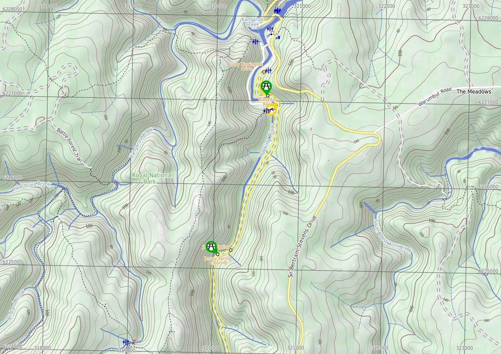
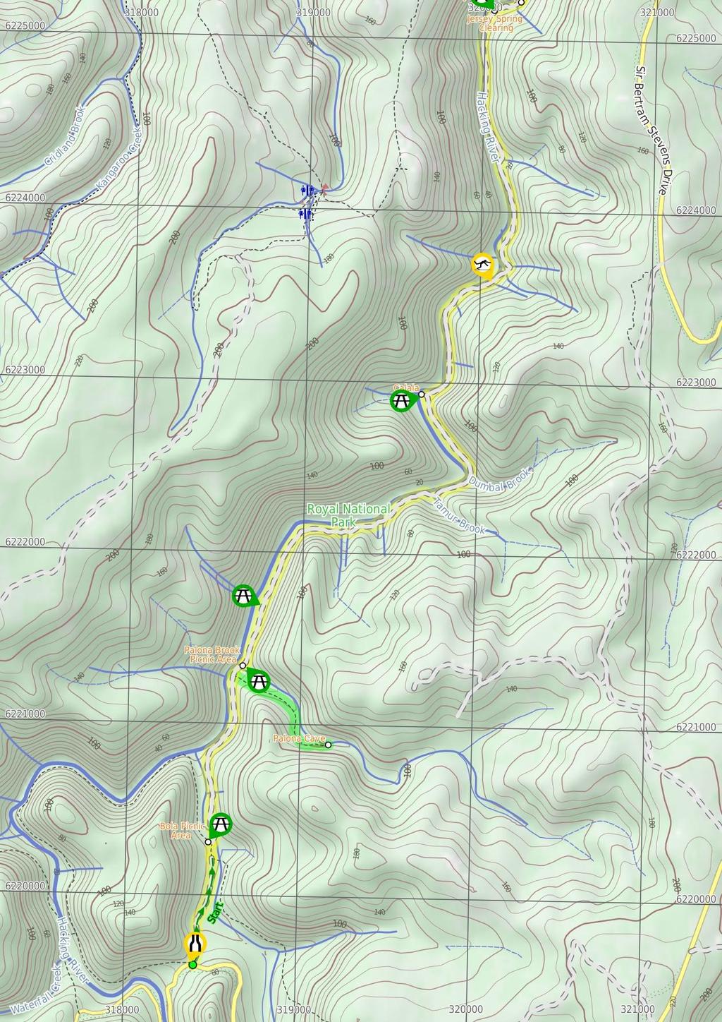
1 Lady Carrington Drive 3 hrs 45 mins 9.7 km One way Moderate track 3 266m This walk follows the historic Lady Carrington Drive alongside the Hacking River. The old road is closed to traffic and provides a great way for walkers (and mountain bikers) to explore the richness of Royal National Park. You can explore the fantastic natural sandstone rock formations, historical artefacts, read the information signs, rest in the picnic areas and appreciate the magnificent native trees. You may well be lucky enough to spot lyrebirds. The southern end has the steepest sections with the walk becoming generally flatter as you head north. 73m 0m Royal National Park Maps, text & images are copyright wildwalks.com Thanks to OSM, NASA and others for data used to generate some map layers.
2 Bola Picnic Area Before You walk Bola Picnic Area, in the Royal National Park, is at the intersection of Lady Carrington Drive and Forest Island Track, beside Bola Creek. You will find a small clearing with a picnic table in a gorgeous rainforest setting, surrounded by tall trees and ferns scattered through the area. There is no car access to the picnic area, making this a lovely quiet area. Bushwalking is fun and a wonderful way to enjoy our natural places. Sometimes things go bad, with a bit of planning you can increase your chance of having an ejoyable and safer walk. Before setting off on your walk check Palona Cave Palona Cave is off Lady Carrington Drive, north of Bola Picnic Area, in the Royal National Park. Palona Cave is a large limestone overhang with a few cave decorations such as columns and stalactites. Being open to the environment, the cave has some green moss and is not reminiscent of other pristine white limestone caves. The cave is a unique feature for the area and is well worth allowing time to explore. Palona Brook Picnic Area Palona Brook Picnic Area is found on the north side of Palona Brook along side the old Lady Carrington Drive. The picnic area is home to a couple of wooden picnic tables and is next to the steep gully and culvert that Palona Brook flows through. A pleasant spot to rest when visiting the nearby sandstone cove or exploring the old road. Calala The signposted 'Calala' clearing lies between the old Lady Carrington Drive and the Hacking River. The large clearing has a picnic table and plenty of shade from the surrounding trees. There is an informal steep track that provides access to a small sandy beach on the Hacking River, making this a lovely spot to rest on a warm day. Jersey Spring Clearing The Jersey Spring Clearing is an open grassy area between the old Lady Carrington Drive and the Hacking River. The clearing is not formally named but is just south of the Jersey Spring. This is a great area to stop, rest and enjoy the journey along the old road 1) Weather Forecast (BOM Metropolitan District) 2) Fire Dangers (Greater Sydney Region) 3) Park Alerts (Royal National Park) 4) Research the walk to check your party has the skills, fitness and equipment required 5) Agree to stay as a group and not leave anyone to walk solo Think before you TREK The 'Think before you TREK' program developed by NSW Police & NPWS promotes the benefits of planning ahead for your bushwalking trip by using an easy to remember acronym: adequate supplies of food, water, navigation and first T Take aid equipment. your planned route and tell friends and family when R Register you expect to return. beacon (PLB's) should be carried on walks with E Emergency significant gaps in mobile coverage (check terrain profile). to your planned route and follow the map and walking K Keep trails. Topo Maps The maps provided on wildwalks are helpful, but there are times where you may need maps covering a broader area. Maps that cover this walk include; 1: Map Series:91294S OTFORD, 91294N PORT HACKING 1: Map Series:9129 PORT HACKING Grade This walk has been graded using the AS The overall grade of the walk is dertermined by the highest classification along the whole track. 3 Grade 3/6 Moderate track Length 9.7 km One way Time 3 hrs 45 mins Quality of track Clear and well formed track or trail (2/6) Signs Directional signs along the way (3/6) Experience Required Some bushwalking experience recommended (3/6) Weather Weather generally has little impact on safety (1/6) Infrastructure Generally useful facilities (such as fenced cliffs and seats) (1/6)
3 Are you ready to have fun? Please ensure you and your group are well prepared and equipped for all possible hazards and delays. Check park closures, weather information and Fire Danger Rating before setting out. Optional side trips and alternate routes noted are not included in this walks overall grade, length or time estimate. Please allow extra time for resting and exploring areas of interest. The authors, staff and owners of wildwalks take care in preparing this information but will not accept responsibility for any inconvenience, loss or injury you may experience. Please take care, have fun - Happy Walking. Getting there Traveling by is the only practical way to get to Int of Lady Carrington Drive and Sir Bertam Stevens Drive (gps: , ). Traveling by car is the only practical way to get back from Lady Carrington Drive gate (Willow Tree) (gps: , ). Car: A park entry fee is required for driving into the park. Car: Parking fees apply in the area. Find up to date and more information inlcuding; travel directions, weather, park closures and walker feedback at Palona Cave is off Lady Carrington Drive, north of Bola Picnic Area, in the Royal National Park. Palona Cave is a large limestone overhang with a few cave decorations such as columns and stalactites. Being open to the environment, the cave has some green moss and is not reminiscent of other pristine white limestone caves. The cave is a unique feature for the area and is well worth allowing time to explore Int Palona Cave Trk and Lady Carrington Drive (110 m 2 mins) Continue straight: From the intersection, this walk heads downhill along the main wide trail as it soon bends to the right. After about 50m the trail crosses the signposted and culverted 'Palona Brook' to come to a picnic area (on the right-hand side) Palona Brook Picnic Area Palona Brook Picnic Area is found on the north side of Palona Brook along side the old Lady Carrington Drive. The picnic area is home to a couple of wooden picnic tables and is next to the steep gully and culvert that Palona Brook flows through. A pleasant spot to rest when visiting the nearby sandstone cove or exploring the old road. 0 Int of Lady Carrington Drive and Sir Bertam Steven (730 m 13 mins) From the car park on Sir Bertram Stevens Drive (500m north of the intersection with McKell Ave), this walk heads between the boulders (on the western edge of the car park) then leads downhill to get around to the back of the locked gate (56cm high) and sandstone wall. From here the walk follows the wide dirt Lady Carrington Drive trail downhill past the 'Forest Path' information sign and continues mostly downhill for just over 600m through the forest to come to a three-way intersection signposted with the 'Walumarra Track'. Continue straight: From the intersection, this walk heads downhill along the main wide dirt trail, keeping the valley to the right. The trail bends right and leads down into the valley for about 60m passing the 'red cedar' information sign to come to the signposted three-way intersection with 'The Forest Path' beside the the Bola Creek picnic area, just before the creek Palona Brook Picnic Area (2.6 km 53 mins) Continue straight: From beside the Palona Brook picnic area, this walk heads gently uphill along the wide trail away from 'Palona Brook' keeping the main valley to the left. The trail leads through the forest for about 400m to pass an old picnic table (about 20m off the left-hand side of the trail) then about 600m later the trail leads past a small metal plaque (on a rock) reminding of the tragic loss of Alan Rendell, who died fighting bushfires here in The walk now continues gently undulating along the wide trail for another 400m to pass signposted (and culverted) 'Burunda Brook' in a pleasant rainforest environment. The trail continues to lead as it winds through the forest for just over 1km, passing the site of a repaired landslide, crossing a few culverted creeks to then come to the sign posted and large 'Calala' clearing (on the left) Bola Picnic Area Bola Picnic Area, in the Royal National Park, is at the intersection of Lady Carrington Drive and Forest Island Track, beside Bola Creek. You will find a small clearing with a picnic table in a gorgeous rainforest setting, surrounded by tall trees and ferns scattered through the area. There is no car access to the picnic area, making this a lovely quiet area Calala The signposted 'Calala' clearing lies between the old Lady Carrington Drive and the Hacking River. The large clearing has a picnic table and plenty of shade from the surrounding trees. There is an informal steep track that provides access to a small sandy beach on the Hacking River, making this a lovely spot to rest on a warm day Bola Picnic Area (1 km 21 mins) Continue straight: From the intersection, this walk follows the 'Audley 9km' arrow gently downhill along the wide trail to cross the culverted Bola Creek. The trail then bends left and leads steeply up for about 200m where the trail then gently undulates through the forest for about 800m before coming to the faint intersection, with the signposted 'Limestone Cave' bush track (the timber sign is behind a tree on the left, before the signposted 'Palona Brook') Calala (2.6 km 51 mins) Continue straight: From 'Calala', this walk follows the main wide management trail (old road), keeping the Hacking River to the left. Over the next 1km, the trail crosses two culverted creeks (Murrindum Brook and Dirijiri Brook) before crossing the more distinct valleys of Birumba and Kobado Brooks. (Kobado Brook has an old small sandstone water trough). The walk then continues winding along the old Lady Carrington Drive, passing over several more culverted creeks and coming down to an area with several palm groves and a large clearing (on the left). The clearing is not signposted but is known as Jersey Spring clearing and has a picnic table Optional sidetrip to Palona Cave and Waterfall (780 m 19 mins) Turn right: From the intersection, this walk follows the 'Limestone Cave 1.6km' arrow along the track, heading up the hill and away from the road. The walk continues up a long hill, winding through dense forest for a short while before flattening out and continuing along the side of the hill. The walk winds through the bush and passes several rock overhangs and outcrops either side of the track, as the walk make its way along to the Palona Caves at the end of the track. At the end of this side trip, retrace your steps back to the main walk then Turn right Palona Cave 7.04 Jersey Spring Clearing The Jersey Spring Clearing is an open grassy area between the old Lady Carrington Drive and the Hacking River. The clearing is not formally named but is just south of the Jersey Spring. This is a great area to stop, rest and enjoy the journey along the old road 7.04 Jersey Spring clearing (130 m 3 mins) Continue straight: From the clearing, this walk follows old Lady Carrington Drive management trail uphill keeping the Hacking River to the left. After about 100m the trail leads past a 'Jersey Springs' information sign and comes to the two sandstone sandstone 'Jersey Spring' troughs Jersey Spring The Jersey Spring is beside the old Lady Carrington Drive in the Royal National Park. The permanent spring feeds into two sandstone troughs, built in 1892 to provide water for horses and people traveling along the road. The troughs are still fed by the same spring (although it has moved overtime and the water is no longer suitable for drinking). The springs are named after Rt. Hon. Victor George (Earl of Jersey), the 17th governor of NSW. More info Jersey Spring (2.1 km 39 mins) Continue straight: From 'Jersey Spring', this walk follows the old road, keeping the Hacking River to the left. The walk continues along the trail as it gently undulates and winds along the side of the Hacking River for just shy of 2km to pass over Mullion Brook on an old sandstone culvert and past a series of palm groves. About 100m after Mullion Brook this walk comes to the picnic table at Gibraltar Rock with a cobblestone section of trail below the overhang Gibraltar Rock Gibraltar Rock, Royal National Park, is a sandstone overhang found near the northern end of Lady Carrington Drive. The old road passes under the rocks and is home to a small section of sandstone cobblestone. At this point, the old road offers great views of the Hacking River and across to Wattle Forest picnic area. These and many other sandstone formations, together with the history, make this old road quite interesting to explore. There is a picnic table under the overhang Gibraltar Rock (430 m 8 mins) Continue straight: From the Gibraltar Rocks, this walk follows the management trail gently downhill (keeping the river to the left), off the cobble stoned area. The walk continues along the dirt trail for about 400m, to head around the locked gate and come to an intersection just past the 'Lady Carrington Drive' sign Lady Carrington Drive Opened in 1886 by Lady Carrington, this road was formally named 'Lady Carrington Road' (later changed to 'drive'), and started on the southern side of the then newly constructed Audley weir. The road became popular among people exploring the region. The road follows the Hacking River's east bank and then Bola Creek to Sir Bertram Stevens Drive. Much history has been preserved, with several drinking troughs still filling with water and many sandstone retaining walls still standing. The brooks that the old road crosses have been named using the traditional names of birds, the following is a list with the English name in brackets. Mullion (Eagle), Wurrul (Bee Eater), Burowa (Bustard), Karonga (White Crane), Gorra Worra (Laughing Jackass), Buralga (Native Companion), Kobardo (Parrot), Birumba (Plover), Dirijiri (Wagtail), Murrindum (Quail), Dumbal (Crow), Tamur (Bronze winged Pigeon), Burunda (Swan), Karani (Duck), Palona (Hawk) Brooks.
4
5
6 Summary navigation sheet for the Lady Carrington Drive km From 0.00 Int of Lady Carrington Drive and Sir Bertam Stevens Drive , (GR Otford, ) 0.73 Bola Picnic Area , (GR Otford, ) Int Palona Cave Trk and Lady Carrington Drive , (GR Otford, ) Int Palona Cave Trk and Lady Carrington Drive , (GR Otford, ) Palona Brook Picnic Area , (GR Otford, ) Calala , (GR Port Hacking, ) Jersey Spring clearing , (GR Port Hacking, ) Jersey Spring , (GR Port Hacking, ) Gibraltar Rock , (GR Port Hacking, ) Up/Dwn Length Initial directions (Use full tracknotes and maps for more detail) m 13 mins From the car park on Sir Bertram Stevens Drive (500m north of the intersection with McKell Ave), this walk heads between the boulders (on the western edge of the car park) then leads downhill to get around to the ba km 21 mins 780 m 19 mins 110 m 2 mins 2.6 km 53 mins 2.6 km 51 mins 130 m 3 mins 2.1 km 39 mins 430 m 8 mins Continue straight: From the intersection, this walk follows the 'Audley 9km' arrow gently downhill along the wide trail to cross the culverted Bola Creek. Optional sidetrip to Palona Cave and Waterfall. Turn right: From the intersection, this walk follows the 'Limestone Cave 1.6km' arrow along the track, heading up the hill and away from the road. Continue straight: From the intersection, this walk heads downhill along the main wide trail as it soon bends to the right. Continue straight: From beside the Palona Brook picnic area, this walk heads gently uphill along the wide trail away from 'Palona Brook' keeping the main valley to the left. Continue straight: From 'Calala', this walk follows the main wide management trail (old road), keeping the Hacking River to the left. Continue straight: From the clearing, this walk follows old Lady Carrington Drive management trail uphill keeping the Hacking River to the left. Continue straight: From 'Jersey Spring', this walk follows the old road, keeping the Hacking River to the left. Continue straight: From the Gibraltar Rocks, this walk follows the management trail gently downhill (keeping the river to the left), off the cobble stoned area.

7 Accessibility Profile This page is designed to give you a sense of the facilities that help improve access for people with disabilities or mobility restrictions. See tracknotes and map for navigation, point of interest and other information. See the Accessibility Details page for specific information about each facility. Parking: There are 0 designated accessible parking areas on this walk. Toilets: There are 0 toilets on this walk. Seats: There are 6 seats on this walk. They are on average 1850m apart, with a maximum gap of 2640m. Surface This walk follows a 5.5m wide dirt trail (old road) for most of the length. All creeks have bridges (culverts). The trail becomes boggy after rain. There are two pinch points, the narrowest is at the southern end at 56cm. Steepness The majority of this walk is gently undulating, although there are some very steep sections at the southern end. If using a wheelchair, assistance is most likely to be required on some of the hills. This graph shows how steep the track is. 3 Grade 3/6 Moderate track Length 9.7 km One way Time 3 hrs 45 mins Quality of track Clear and well formed track or trail (2/6) Signs Directional signs along the way (3/6) Experience Required Some bushwalking experience recommended (3/6) Weather Weather generally has little impact on safety (1/6) Infrastructure Generally useful facilities (such as fenced cliffs and seats) (1/6)

 (2250m) seat. seat. The table is 68cm high, 93cm deep and 2.")
 Trip Hazard (5310m) seat. The table is 77cm high, 91cm deep and 2.")


 seats.")
.")

8 Accessibility Details 1 Pinch Point (10m) (750m) seat. The table is 76cm high, 91cm deep and 2.12m wide. The seats are 44cm high, 30cm deep and 2.12m wide (no backrest). 3 4 (1890m) (2250m) seat. The table is 76cm high, 91cm deep and 2.12m wide. The seats are 44cm high, 30cm deep and 2.12m wide (no backrest). seat. The table is 68cm high, 93cm deep and 2.14m wide. The seats are 34cm high, 31cm deep and 2.14m wide (no backrest). 5 6 (4410m) Trip Hazard (5310m) seat. The table is 77cm high, 91cm deep and 2.1m wide. The seats are 39cm high, 30cm deep and 2.1m wide (no backrest). A number of the culverts crossing creeks along Lady Carrington Drive have unfenced and unmarked edges. The potential fall is significant enough to cause serious injury or death. Stay well clear of the edges. 7 8 (7050m) Trip Hazard (9110m) seat. The table is 77cm high, 93cm deep and 2.1m wide. The seats are 42cm high, 30cm deep and 2.1m wide (no backrest). There are a number of tall stone walls and culverts crossing creeks along Lady Carrington Drive that are unfenced and have unmarked edges. The potential fall is significant enough to cause serious injury or death. Stay well clear of the edges (9260m) seats. The table is 79cm high, 91cm deep and 2.1m wide. The seats are 40cm high, 30cm deep and 2.1m wide (no backrest). Powered by TCPDF ( 2 Pinchpoints between rocks. The widest space is between the 5th and 6th rock from the fence (at the west side of car park) is 56cm wide. Trip Hazard (9280m) An 8cm trip hazard between dirt and cobblestones.
Congewai Track Head (East) to Watagan Headquarters
 to Watagan Headquarters") Congewai Track Head (East) to Watagan Headquarters 7 hrs Hard track 17.2 km One way 4 973m This full day walk starts from the Congewai valley trackhead (east) and follows the Great North Walk up into the
Congewai Track Head (East) to Watagan Headquarters 7 hrs Hard track 17.2 km One way 4 973m This full day walk starts from the Congewai valley trackhead (east) and follows the Great North Walk up into the
Nature Track. 900m. 789m. 2 hrs 3.1 km Circuit. Hard track 238m. Blue Mountains National Park
 Nature Track 2 hrs 3.1 km Circuit Hard track 238m Largely following the ridges around the top edge of Wentworth Falls, this track is incredibly beautiful. After taking in the great views at Edinburgh Castle
Leura Cascades to Gordon Falls Reserve
 Leura Cascades to Gordon Falls Reserve 1 hr 15 mins 1.8 km One way Moderate track 200m From Leura Park to Gordon Falls Park, this diverse walk offers fantastic views of the Jamison Valley, as well as two
Berowra Waters to Cowan Station
 Berowra Waters to Cowan Station 3 hrs 30 mins 7.2 km One way Hard track 597m This is a hilly walk out of the beautiful Berowra Waters valley to Cowan Station. There are many wide views across Berowra Creek
Merritts Traverse. 1928m
 Merritts Traverse 3 hrs Hard track 5.8 km Circuit 4 167m This walk starts with a scenic journey to the top of the hill on the chairlift. Starting along Merritts Nature walk, this walk soon detours down
Victoria Falls Lookout to Blue Gum Forest
 Victoria Falls Lookout to Blue Gum Forest 8 hrs Experienced only 13.8 km One way 5 112m This long day-walk follows a remote track down from Victoria Falls lookout, passing the waterfall, and into the Grose
Staples Lookout to Mt Wondabyne loop
 Staples Lookout to Mt Wondabyne loop 4 hrs 3 mins 1.8 km Circuit Hard track 337m This walk starts and finishes at Staples Lookout, on Woy Woy Rd. The walk follows sections of the Great North Walk around
Girrakool to Wondabyne station
 Girrakool to Wondabyne station 4 hrs Hard track 9.5 km One way 4 438m This walk starts from the Girrakool picnic area and winds south, through the Brisbane Waters National Park. The walk crosses some long
Abbotts Falls Walking Track
 Abbotts Falls Walking Track 3 hrs 7.3 km Circuit Hard track 329m This circuit takes you through both dry and moist forest, using a combination of walking trails and wider tracks. The side trip to the dammed
Mt Kuring-gai Track to Berowra station
 Mt Kuring-gai Track to Berowra station 4 hrs 15 mins 9.7 km One way Hard track 4 553m This walk explores three valleys, with great displays of wild flowers in spring, and some nice sandstone overhangs.
Erskine Creek via Pisgah Rock and Jack Evans
 Erskine Creek via Pisgah Rock and Jack Evans 4 hrs 30 mins 7.1 km Circuit Very experienced only 6 421m This walk visits some great lookouts and explores the lower section of Erskine Creek. Most of the
Guthega to Mt Twynam. 2183m. 1583m. 6 hrs 45 mins 14.8 km Return. Experienced only. 913m
 Guthega to Mt Twynam 6 hrs 45 mins 14.8 km Return Experienced only 5 913m This walk starts from Guthega and makes its way along the Snowy River to the Illawong Lodge, via the Blue Cow Creek flying fox.
National Pass. 893m. 665m. 3 hrs 30 mins 4.6 km Circuit. Hard track 773m. Blue Mountains National Park
 National Pass 3 hrs 3 mins 4.6 km Circuit Hard track 773m 4 This walk offers fantastic views of the Jamison Valley and the surrounding cliffs. Take time to explore the historic and very scenic ledge halfway
Wentworth Pass. 893m. 535m. 4 hrs. Hard track 5.1 km Circuit. 692m
 Wentworth Pass 4 hrs Hard track 5.1 km Circuit 4 692m This walk offers a great way to explore the magical, upper section of the Valley of the Waters. The walk starts and finishes at Conservation Hut, which
Girrakool to Wondabyne station via Pindar caves
 Girrakool to Wondabyne station via Pindar caves 7 hrs 30 mins 18.1 km One way Experienced only 5 741m This walk starts from the Girrakool picnic area and winds south, following Piles creek into the Brisbane
Berowra to Cowan via Berowra Waters
 Berowra to Cowan via Berowra Waters 6 hrs Hard track 12.9 km One way 4 884m With train station at each end this walk explores the ridges and valleys around Berowra Waters. There are plenty of excellent
Scenic Railway to Ruined Castle
 Scenic Railway to Ruined Castle 7 hrs 30 mins 12.4 km Return Hard track 4 963m This is a very popular, full day walk, in the Katoomba Area, offering great views of the valley. The walk follows the edge
Gibberagong Track. 169m
 Gibberagong Track 2 hrs 30 mins 6.5 km One way Hard track 4 180m Starting in suburban Wahroonga, this wellmaintained track follows Cockle Creek down to Bobbin Head in the Ku-ring-gai Chase National Park.
Crosslands to Berowra Waters return
 Crosslands to Berowra Waters return 6 hrs Hard track 13.7 km Return 4 1005m This return walk starts from the Crosslands Reserve and follows the Great North Walk along Berowra creek. The walk includes some
Crosslands to Cowan. 220m
 Crosslands to Cowan 7 hrs 30 mins 14 km One way Hard track 4 1103m This section of the Great North Walk starts from the Crosslands camping area and winds north alongside Berowra creek, passing through
Victoria Falls to Blackheath Station
 Victoria Falls to Blackheath Station 2 Days Experienced only 22.2 km One way 5 1561m This is a fantastic overnight walk with a sleep in Acacia Flats camping area. The Grose Valley, with its views of the
Dadder Cave and Jack Evans track
 Dadder Cave and Jack Evans track 2 Days 10.3 km Circuit Very experienced only 535m This fairly short overnight walk is a great way to explore Erskine Creek. The walking along Erskine creek is mostly off
Victoria Falls and Grose Valley to Blackheath Station
 Victoria Falls and Grose Valley to Blackheath Station 3 Days Experienced only 22.5 km One way 5 158m This walk explores a fantastic section of the Grose Valley. Starting above Victoria Falls, the walk
Jerusalem Bay Track (Cowan to Brooklyn)
") Jerusalem Bay Track (Cowan to Brooklyn) 5 hrs 30 mins 13.4 km One way Hard track 4 654m This Cowan to Brooklyn Station walk is a popular section of the Great North Walk, with scenery ranging from foreshore
Jerusalem Bay Track (Cowan to Brooklyn) 5 hrs 30 mins 13.4 km One way Hard track 4 654m This Cowan to Brooklyn Station walk is a popular section of the Great North Walk, with scenery ranging from foreshore
Patonga to Staples Lookout
 Patonga to Staples Lookout 6 hrs 3 mins 17 km One way Hard track 4 72m This great walk explores much of the main ridge ridge running through Brisbane Water National Park. The walk visits a number of great
Patonga to Wondabyne station via Mt Wondabyne
 Patonga to Wondabyne station via Mt Wondabyne 7 hrs 3 mins 19.5 km One way Hard track 4 861m This walk explores some grand views, pleasant cascades, varied bushland and remote areas of Brisbane Waters
Leura to Katoomba via Dardanelles Pass
 Leura to Katoomba via Dardanelles Pass 4 hrs 6.6 km One way Hard track 697m With approximately equal parts cliff-walk and forest track, this track truly shows what the cliff edges of the Jamison Valley
Hornsby station to Crosslands
 Hornsby station to Crosslands 6 hrs 45 mins 16.1 km One way Hard track 4 938m This section of the Great North Walk starts from Hornsby train station and winds down along the Blue Gum Walk into Fishponds.
Main Range Walk - Charlotte Pass to Mount Kosciuszko
 Main Range Walk - Charlotte Pass to Mount Kosciuszko 9 hrs Hard track 21.9 km Circuit 4 920m This full day walk explores some of the greatest alpine country on offer in NSW. The walk grants views of Blue,
Somersby to Yarramalong via Stringy Bark Point
 Somersby to Yarramalong via Stringy Bark Point 2 Days Hard track 26.7 km One way 4 1201m This section of the Great North Walk starts form the Somersby General Store and follows the Great North Walk north
Main Range Track - Loop from Charlotte Pass camping near Mt Townsend
 Main Range Track - Loop from Charlotte Pass camping near Mt Townsend 2 Days Experienced only 27.7 km Circuit 5 1260m This great overnight walk starts from Charlotte Pass and provides access to some of
Blackheath to Blue Gum loop
 Blackheath to Blue Gum loop 2 Days Hard track 24.1 km Circuit 4 1335m This walk is great for fit people getting into overnight walking, with its fantastic scenery and nostalgia as a classic overnighter.
The Prince Henry Cliff Walk
 The Prince Henry Cliff Walk 3 hrs 30 mins 6.8 km One way Moderate track 3 575m Going from Katoomba to Leura, this walk covers the top of the cliff line and most of the major lookouts. With brilliant vistas
Somersby to the Basin Campsite
 Somersby to the Basin Campsite 3 Days Hard track 47.4 km One way 4 2032m This three day walk starts at the Somersby General Store and follows the Great North Walk, heading north, into the the Jilliby State
Patonga to Wondabyne station via Pindar Caves overnight
 Patonga to Wondabyne station via Pindar Caves overnight 2 Days Experienced only 28.1 km One way 5 1164m This overnight hike starts from Patonga beach and winds along a section of the Great North Walk,
Berowra to Hornsby. 9 hrs 18 mins 22.6 km One way. Hard track. 1423m
 Berowra to Hornsby 9 hrs 18 mins 22.6 km One way Hard track 4 1423m One of the longer day walks in Berowra Valley National Park, this walk mostly follows Berowra Creek along the Great North Walk. Excellent
Wondabyne station to Somersby Store
 Wondabyne station to Somersby Store 10 hrs Hard track 26.2 km One way 4 1164m This walk, following a section of the Great North Walk, starts from the Wondabyne train station and winds north, into the Brisbane
Guthega to Thredbo camping overnight at Wilkensons Creek
 Guthega to Thredbo camping overnight at Wilkensons Creek 2 Days Experienced only 25.8 km One way 5 1364m This great overnight walk explores the Kosciusko National Park between Guthega and Thredbo, visiting
Cowan to Wondabyne station via Patonga rest area
 Cowan to Wondabyne station via Patonga rest area 2 Days Hard track 33.4 km One way 4 1523m This section of the Great North Walk starts from Cowan train station and wanders past the majestic Jerusalem Bay
Crosslands to Brooklyn
 Crosslands to Brooklyn 2 Days Hard track 27.4 km One way 4 1757m From the Crosslands Reserve, this walk heads along the Great North Walk via Berowra Waters, Cowan, Jerusalem Bay and onto Brooklyn. This
Victoria Falls and Grose Valley to Blackheath Station
 This walk explores a fantastic section of the Grose Valley. Starting above Victoria Falls, the walk explores the cascades before dropping into the valley for the first nights rest at Burra Korain campsite.
Katoomba to Wentworth Falls via the Jamison Valley
 Katoomba to Wentworth Falls via the Jamison Valley 2 Days Experienced only 29.2 km One way 5 2135m This is the two day version of this popular and challenging walk. This walk passes popular sights including
Western Commission Track to Dubbo Gully
 This two day walk follows a series of historic roads along clear and wide management trails. This walk explores the great views from Western Commission Track, the sandstone handicraft on the Old Great
Gordon to Hornsby (overnight at Scout camp)
") Gordon to Hornsby (overnight at Scout camp) 2 Days Hard track 25.8 km One way 4 125m This overnight walk starts from Gordon train station and winds through bush filled valleys to Hornsby station. From
Gordon to Hornsby (overnight at Scout camp) 2 Days Hard track 25.8 km One way 4 125m This overnight walk starts from Gordon train station and winds through bush filled valleys to Hornsby station. From
Main Range Circuit from Guthega
 Main Range Circuit from Guthega 4 Days Experienced only 45 km Circuit 5 2317m This four day walk explores the Kosciuszko National Park, covering many of the key features of the park between Guthega and
Thornleigh to Cowan. 2 Days. Hard track 35.9 km One way. 2337m
 Thornleigh to Cowan 2 Days Hard track 35.9 km One way 4 2337m Following the Great North Walk and Berowra Creek through Berowra Valley Regional Park, this walk cuts straight through the length of the Park.
Out and about at Geehi
 Geehi Geehi Flats is a large area of flat floodplain on the banks of the Swampy Plains River. Located within Kosciuszko National Park, it is home to a popular campsite in summer for people wanting to enjoy
COLOUR G U I D E. Sydney to Newcastle: Australia s most accessible long-distance walk
 COLOUR G U I D E Sydney to Newcastle: Australia s most accessible long-distance walk Woodslane Press Pty Ltd Unit 7/5 Vuko Place Warriewood, NSW 2102 Australia Email: info@woodslane.com.au Tel: (02)
Slad over to Pitchcombe and back
 The walk climbs up from Slad over Wickridge Hill, descends to near Pitchcombe, then climbs back over Wickridge hill and round the back of Slad. Page 1 Start Point: SO 8718 0732 The Woolpack, Slad Length:
Tiger Mountain State Forest:
 98 60 hikes within 60 miles: SEATTLE 20 Tiger Mountain State Forest: West Tiger Mountain Three Loop i KEY AT-A-GLANCE INFORMATION Length: 5.1 miles round-trip Configuration: Loop Difficulty: Moderate difficult
Illawarra Escarpment State Conservation Area Walking Tracks
 Illawarra Escarpment State Conservation Area Walking Tracks NPWS Illawarra Area Office Ground Floor, Government Office Block 84 Crown Street Wollongong NSW 2500 02 4223 3000 (Mon-Fri) Royal National Park
Printed in China by Designed by Coral Lee Main cover image: Broken Bay
 Woodslane Press Pty Ltd Unit 7/5 Vuko Place Warriewood, NSW 2102 Australia Email: info@woodslane.com.au Tel: (02) 9970 5111 Fax: (02) 9970 5002 http://travelandoutdoor.bookcentre.com.au First published
Hindhead, Keffolds Copse and Gibbet Hill
 point your feet on a new path, Keffolds Copse and Gibbet Hill Distance: 6 km=4 miles Region: Surrey Author: Schwebefuss Refreshments: Punch Bowl Café moderate walking Date written: 14-apr-2015 Last update:
Little Grand Canyon near Pomona, Illinois
 Little Grand Canyon near Pomona, Illinois Below: View of the trail and the terrain created using the Map My Hike app Below: Summary of the hike created using the Map My Hike app Presented by: Jennifer
Trail Phasing Plan. Note: Trails in the Clear Creek Canyon area (Segments will be finalized in the future to minimize wildlife impacts
 Note: Trails in the Clear Creek Canyon area (Segments 2 5 and a future JCOS connection) will be finalized in the future to minimize wildlife impacts Trail Phasing Plan P Parking 3 Easy Trail Intermediate
Supplemental No. 8 AGENDA ITEM #6.B Distributed 9/19/17
 Supplemental No. 8 AGENDA ITEM #6.B Distributed 9/19/17 18 Sept, 2017 To: Los Altos Hills Mayor Waldeck and Members of the Los Altos Hills City Council Re: 27333 Ursula Lane request for pathway removal
GOLDEN EARS PROVINCIAL PARK
 GOLDEN EARS PROVINCIAL PARK Trail Information as of October 10 th 2015 Do not underestimate the mountainous wilderness of Golden Ears Provincial Park. The combination of rugged terrain and rapidly changing
ID: 283 Distance: 6.2 miles Height gain: 500 Metres Map: Explore OL 19 Contributor David and Chris Stewart
 Walkingworld Wild Boar Fell ID: 283 Distance: 6.2 miles Height gain: 500 Metres Map: Explore OL 19 Contributor David and Chris Stewart Features Birds, Great Views, Hills or Fells Description: Wild Boar
Beautiful Walks from the Blue Ball Inn
 Walk No. 5 RIVER VALLEYS AND MOOR Countisbury, Watersmeet, Hillsford Bridge, Cheriton, Shilstone Hill, Rockford and Chiselcombe. 8.5 MILES APPROX. Walking time four and a half hours approx. OS 1;25,000
Our Murray River Beaches
 Page 1 of 5 Our Murray River Beaches Click here to print this page West of Yarrawonga are many access points to the river. Earth tracks lead from the Murray Valley Highway through state forests to picnic
The Mendip Way. Route Directions and Maps Uphill to Wells
 The Mendip Way Route Directions and Maps Uphill to Wells Website: www.mendiphillsaonb.org.uk Email: mendip@mendiphillsaonb.org.uk Facebook & Twitter: @MendipHillsAONB Phone: 01761462338 1 Uphill to Loxton
Fetcham Downs and Bocketts Farm A magical teashop walk
 point your feet on a new path Fetcham Downs and Bocketts Farm A magical teashop walk Distance: 3 km=2 miles or 4 km=2½ miles Region: Surrey Author: Fusszweig Refreshments: Bocketts Farm easy walking Date
Pontfadog. Walk A. Walk A
 Walk A A Bird s eye view of the village 2km. (1 1 /2 miles); height gain 45m. (150ft) about 45 minutes. Six minutes walk along the main road towards Glyn Ceiriog reach a signpost to Llwynmawr. Take the
Beautiful Walks from the Blue Ball Inn
 Walk No. 2 WINSTONS WALK Countisbury, Wind Hill, Watersmeet, Ash Bridge and Winston s path. 5 Miles approx. Walking time- Two and a half hours approx. (Not including Breaks) OS 1:25,000 Sheet 64/74 Lynton
e-news TRACK REGENERATION WORK AT DINGO DELL, WEST OF SYDNEY.
 e-news TRACK REGENERATION WORK AT DINGO DELL, WEST OF SYDNEY. By the project coordinator, Matt Barnes, Public Relations Officer for the Land Rover Owners Club of Australia (Sydney Branch) Inc One of the
Access. Road from start point (W01) to campground (W56) Water Taxi Pick-up (W03)
 to campground (W56) Water Taxi Pick-up (W03)") WAIKAREMOANA GREAT WALK 260 Series Map: W18 Waikaremoana NZ Grid GPS: Geodetic Datum 1949 Topo50 Maps: BG39 Ruatahuna & BG40 Waikaremoana Gaps: on WGS84 Topo250 Map: Sheet 10 To get to START: Exit Taupo
WAIKAREMOANA GREAT WALK 260 Series Map: W18 Waikaremoana NZ Grid GPS: Geodetic Datum 1949 Topo50 Maps: BG39 Ruatahuna & BG40 Waikaremoana Gaps: on WGS84 Topo250 Map: Sheet 10 To get to START: Exit Taupo
Map: Landranger #27 Forres and Nairn and 36 Grantown and Aviemore
 THE DAVA WAY This is a newly created long distance route that runs from Forres to Grantown, mostly following the old railway line. You will need to detour around a couple of sections that are not really
Self-Guided Walk Langdale Pikes. Start & Finish: NT car park (free to members) at Sticklebarn - on the right just beyond the New Dungeon Ghyll hotel.
 at Sticklebarn - on the right just beyond the New Dungeon Ghyll hotel.") Self-Guided Walk Langdale Pikes Key Information These mountains form a collection of spires and cliffs on the north side of Langdale. This walk visits four of the main tops Pavey Ark, Harrison Stickle,
Self-Guided Walk Langdale Pikes Key Information These mountains form a collection of spires and cliffs on the north side of Langdale. This walk visits four of the main tops Pavey Ark, Harrison Stickle,
FROM JUTA TO ROSHKA via Chaukhi pass
 FROM JUTA TO ROSHKA via Chaukhi pass Duration: 1-2 days The hike can take one or two days, depending on how you plan it. I will focus on the 1-day version of the trek which takes 8-9 hours and starts in
Walk 1. Cotswold Water Park. Gateway Centre to Cerney Wick, railway track to Lake 6, Gateway Centre.
 Cotswold Water ark Walk way A Swindon/ Cirencester Thomas and Severn Canal way to Cerney Wick, railway track to Lake, way. Spine Road East Hotel Time: hours (short walk km) Distance: km A level walk along
Asheville & WNC Hikes
 Asheville & WNC Hikes Amazingly, we have 3,000+ miles of free public hiking trails near Asheville, including 1,600 miles in the Pisgah and Nantahala National Forests, 850 miles in Great Smokey Mountains
Countryside Trails Dunkeld
 R A N G E R S E RV I C E Countryside Trails Dunkeld WELCOME Welcome to this southern end of Atholl Estates. The countryside here is a wonderful blend of lochs, woodland and heather moor. There is a large
Telluride-to-Moab Alternative Singletrack Options
 Telluride-to-Moab Alternative Singletrack Options Day 1 Day 1 Alternate 1: Galloping Goose to Deep Creek. 18.4 miles, ascent 3,530ft, descent 1,388ft. This is fun, flowey, moderate to intermediate singletrack
Self-Guided Walk Malham, Gordale and Malham Tarn
 Self-Guided Walk Malham, Gordale and Malham Tarn Combine all the major geological attractions of Malham in this walk and hopefully leave enough time to enjoy the cafes, pubs and shops of the village. Malham
Marilla Reservoir to Chestnut Ridge via Marilla Trails and Bullis Hollow Trail east to west
 USGS topographic maps useful to this hike are the Bradford and Stickney 7.5 minute sectionals. These notes are designed to assist in identifying distance and location using geophysical and man-made characteristics
Kakadu Highlights No. 9: September 23 - October 6, 2018
 Kakadu Highlights No. 9: September 23 - October 6, 2018 Section 1: Barramundi Creek: September 23-26 We begin with a four to six hour, 350 kilometre drive from Darwin. The last 45 kilometres is on a 4WD
ROAD SCHOLAR SPRING HIKING ADVENTURE Tentative Schedule April 9-14, 2017
 ROAD SCHOLAR SPRING HIKING ADVENTURE Tentative Schedule April 9-14, 2017 Sunday, April 9 PM 3:00-5:00 Arrival, registration and move in to the dorm. 6:00 Supper EVE 7:15 Welcome & Orientation, Sign Ups
The Great Malvern Town Centre Walk. The Great Malvern Alternative Town Centre Walk
 The Great Malvern Alternative Town Centre Walk This is an abridged version of walk 4, from the Pictorial Guide to the Malvern Hills Book Two: Great Malvern Available from the Tourist Information Centre,
CWMGIEDD FROM ABERCRAVE
 Abercrave to Cwmgiedd Walk Page 1 Starting from The Abercrave Inn. Grid Ref: SN 824128 From the Abercrave Inn, an 11.3km (7 miles) walk to the foothills of the Cribarth Mountain, then through forest to
The Bridestone Rocks from Lydgate
 Print this page Back to results The Bridestone Rocks from Lydgate Ancient tracks and gritstone outcrops, with terrific views of the steepsided Cliviger Valley. Distance 5 miles (8km) Minimum time 2hrs
IRON BARK and COLENSO HUTS 260 Series Map: 1:50, U21 NZ Grid GPS: Geodetic Datum 1949
 IRON BARK and COLENSO HUTS 260 Series Map: 1:50,000 260-U21 NZ Grid GPS: Geodetic Datum 1949 Topo50 Map: BK36 Taoroa Junction GPS: on WGS84 How to get to START: Exit Taupo on SH1 down the lake to Turangi
Ala-Kul trekking guide.
 Ala-Kul trekking guide. The marshrutka 101 brings you to the entrance of the park. For 400 KGS, a taxi will stop between the entrance and the broken bridge, saving at least 1 hour of walk. Download me
TREK THE ROCKIES ABOUT THE CHALLENGE TREK THE ROCKIES FOR HIGHLAND HOSPICE CANADA TREK DEMANDING
 TREK THE ROCKIES CANADA TREK DEMANDING ABOUT THE CHALLENGE The Canadian Rockies are justifiably world-famous for their magnificent scenery: the combination of impressive, jagged mountains, bright turquoise
Sponsored by. statestreet.com
 /STATESTREETISLANDWALK #ISLANDWALKJSY Sponsored by statestreet.com Important Information If you forget everything else PLEASE remember the following.» Remember to check OUT of every checkpoint» If you
Difficult Run Stream Valley Park
 Difficult Run Stream Valley Park The more intense mountain bikers have known about for Difficult Run for some time. Equestrians have known it longer. Eight miles of unpaved trail, the Rails to River Trail
Location: Height: Access: Distance: Elevation: Season: Difficulty: Lat/Long: Directions:
 Upper Eagle Falls Upper Eagle Falls (~20 ft.) is a short hike up from the roadside at the Eagle Falls picnic area. It is very difficult to get a parking spot here during the day, so it is recommended to
A TOUR OF FLORA HOTSPOTS IN THE RIDDELLS CREEK AREA.
 A TOUR OF FLORA HOTSPOTS IN THE RIDDELLS CREEK AREA. Suggested one or two day tour from Melbourne to see the Flora and Nurseries of the Western Plains Grasslands, the Foothills of the Macedon Range and
TREK TO TABLE MOUNTAIN
 SOUTH AFRICA TREK CHALLENGING ABOUT THE CHALLENGE South Africa is a land of incredible contrast and beauty. It possesses a vast array of landscapes, from dense tropical bush to open desert. Our trek takes
A DESERT CAMPING GUIDE FOR ANZA BORREGO DESERT STATE PARK
 A DESERT CAMPING GUIDE FOR ANZA BORREGO DESERT STATE PARK With over 500,000 acres of beautiful terrain, Anza Borrego Desert State Park offers endless opportunities for Boy Scout Troops, Venture Crews and
COSTA BLANCA MOUNTAIN WALKERS - WALK DESCRIPTION. Visit for more walks descriptions in Spain
 COSTA BLANCA MOUNTAIN WALKERS - WALK DESCRIPTION Visit www.walksinspain.org for more walks descriptions in Spain Walk description originally prepared by:- Ralph Phipps Last Updated 25th Sep 2015 Title
CAMELBACK MOUNTAIN: CHOLLA TRAIL
 CITY OF PHOENIX :: Camelback Mountain: Cholla T rail 21 CAMELBACK MOUNTAIN: CHOLLA TRAIL IN BRIEF Camelback Mountain is the tallest point in the city of Phoenix. From the 2,704-foot summit of Camelback,
The rewards more than make up for the efforts of seeing the country this is a truly unforgettable trek.
 MADAGASCAR TREK ORANGE 2 ABOUT THE CHALLENGE This exciting trek takes us to remote Madagascar, where spectacular scenery and amazing wildlife awaits! From canyons and gorges to bush-covered plains and
Lordenshaw. What are cup & ring marks?
 Lordenshaw Lordenshaw hill has one of the largest clusters of ancient cup and ring marked stones in the UK. We ve chosen four interesting spots we d like to share with you. What are cup & ring marks? The
DAY 1: Circular Quay to Greenwich Wharf
 DAY 1: Circular Quay to Greenwich Wharf Total Distance: 14km Time: Approximately 5 hours Walk Notes in Six Sections Section Name Length Time 1:1 Circular Quay to Milsons Point Station 2.5km 50mins 1:2
Singleton and the South Downs
 point your feet on a new path Singleton and the South Downs Distance: 13½ km=8½ miles easy walking with a few steeper sections Region: West Sussex Author: Hautboy Refreshments: Singleton, Hill Barn Date
Matthiessen State Park Dells Area Hike
 90 Easy Hikes Close to Home At the south end of the hike, you ll climb on top of a mound left over from a former coal-mining operation in the park. Not far from Goose Lake Prairie, the town of Morris hosts
For more information and to buy this book click here ISBN: CICERONE. Guides for walkers, trekkers, mountaineers, climbers and cyclists
 For more information and to buy this book click here ISBN: 9781852844103 CICERONE Guides for walkers, trekkers, mountaineers, climbers and cyclists www.cicerone.co.uk SALÈVE AND VALLÉE VERTE SALÈVE WALK
Henderson Mountain Avalanche Accident Two riders caught, one partially buried, one fully buried
 Henderson Mountain Avalanche Accident Two riders caught, one partially buried, one fully buried Custer-Gallatin National Forest 28 November 2014 Synopsis A group of 6 or 7 snowmobilers (part of a larger
Skiing and Snowshoes on Un-groomed Fernan Saddle Terrain
 Skiing and Snowshoes on Un-groomed Fernan Saddle Terrain Three ski or snowshoe routes are available from the Fernan Saddle Parking Lot which either do not cover routes ordinarily groomed for snow machine
London to Oxford Trek map
 London to Oxford Trek map Route stats: 103.6 km (64.4 miles) with 800 metres of climbing Start time: 08:00-09:00am Checkpoints: Start - Spelthorne Leisure Centre TW18 1AJ Distance: 0km (0m) Leave here