Scenic Railway to Ruined Castle
|
|
|
- Cameron Todd
- 5 years ago
- Views:
Transcription


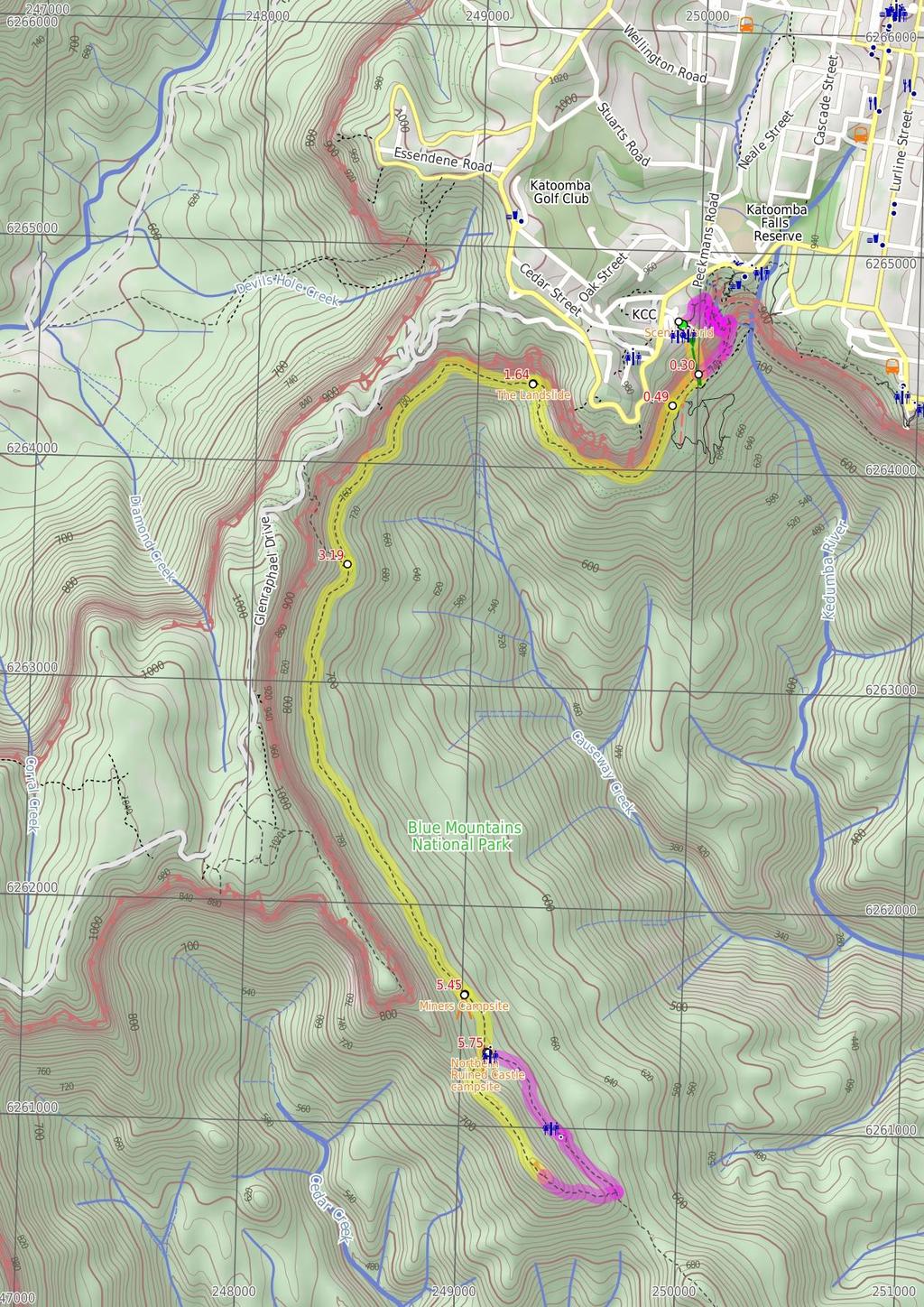
1 Scenic Railway to Ruined Castle 7 hrs 30 mins 12.4 km Return Hard track 4 963m This is a very popular, full day walk, in the Katoomba Area, offering great views of the valley. The walk follows the edge of the cliffs, through the undergrowth, from the Scenic Railway to the Ruined Castle. There are great views to enjoy from the Ruined Castle. Arrive back in time to catch the Scenic Railway back up, or be prepared for the walk up Furber Steps, an alternate exit. 952m 718m Blue Mountains National Park Maps, text & images are copyright wildwalks.com Thanks to OSM, NASA and others for data used to generate some map layers.
 or the Scenic Cableway, into the Jamison Valley, and explore the")
2 Scenic World Before You walk Scenic World is one of the most renowned tourist attractions of Katoomba and the Blue Mountains. Located on the cliffs of the Jamison Valley, visitors can enjoy a ride on the Scenic Railway (the world's steepest incline railway) or the Scenic Cableway, into the Jamison Valley, and explore the Scenic Walkway from the base. Alternatively, the Scenic Skyway offers a bird's eye view over the valley, with a glass floor to enhance the experience. Scenic World also features a revolving restaurant, a cafe and a kiosk, in addition to the documentary theatre and souvenir shop. Rides can be purchased, starting from $16 for adults and $10 for children, and combination or family passes are available. More info. Bushwalking is fun and a wonderful way to enjoy our natural places. Sometimes things go bad, with a bit of planning you can increase your chance of having an ejoyable and safer walk. Before setting off on your walk check The Landslide Think before you TREK 'The Landslide' is a large rockfall going into the valley approximately 100m. There is a good vantage point for the landslide from under the cliffs to the east, and a great but more distant view from Narrow Neck lookout. The landslide occurred in 1931 after a few days of rumbling. There has been much debate as to whether this event was helped along by erosion and coal mining in the area at the time. The 'Think before you TREK' program developed by NSW Police & NPWS promotes the benefits of planning ahead for your bushwalking trip by using an easy to remember acronym: Miners Campsite This flat campsite beside the Federal Pass walking track about 2.2km south of the intersection at the bottom of the Golden Stairs. There is short constructed stone wall left over from when there area was habited by miners. The campsite is surrounded by a tall forest, bracken ferns and some nice fern trees. There is no water or facilities. Miners Campsite This flat campsite beside the Federal Pass walking track about 2.2km south of the intersection at the bottom of the Golden Stairs. There is short constructed stone wall left over from when there area was habited by miners. The campsite is surrounded by a tall forest, bracken ferns and some nice fern trees. There is no water or facilities. Northern Ruined Castle campsite A short distance south east of the intersection with the Federal Pass and the northern access track to the Ruined Castle, is a fairly large basic campsite. There are two main flat areas for camping, both with fire scares. The area is surround with tall trees and ferns. There is no water nor any other facilities. 1) Weather Forecast (BOM Central Tablelands District) 2) Fire Dangers (Greater Sydney Region) 3) Park Alerts (Blue Mountains National Park) 4) Research the walk to check your party has the skills, fitness and equipment required 5) Agree to stay as a group and not leave anyone to walk solo adequate supplies of food, water, navigation and first T Take aid equipment. your planned route and tell friends and family when R Register you expect to return. beacon (PLB's) should be carried on walks with E Emergency significant gaps in mobile coverage (check terrain profile). to your planned route and follow the map and walking K Keep trails. Topo Maps The maps provided on wildwalks are helpful, but there are times where you may need maps covering a broader area. Maps that cover this walk include; 1: Map Series:Six Foot Track 1: Map Series:89302N JAMISON, 89301S KATOOMBA 1: Map Series:8930 KATOOMBA Grade This walk has been graded using the AS The overall grade of the walk is dertermined by the highest classification along the whole track. 4 Grade 4/6 Hard track Length 12.4 km Return Time 7 hrs 30 mins Quality of track Rough track, where fallen trees and other obstacles are likely (4/6) Signs Minimal directional signs (4/6) Experience Required Moderate level of bushwalking experience recommended (4/6) Weather Forecast, unforecast storms and severe weather may impact on navigation and safety (4/6) Infrastructure Limited facilities, not all cliffs are fenced (3/6)
3 Are you ready to have fun? Please ensure you and your group are well prepared and equipped for all possible hazards and delays. Check park closures, weather information and Fire Danger Rating before setting out. Optional side trips and alternate routes noted are not included in this walks overall grade, length or time estimate. Please allow extra time for resting and exploring areas of interest. The authors, staff and owners of wildwalks take care in preparing this information but will not accept responsibility for any inconvenience, loss or injury you may experience. Please take care, have fun - Happy Walking. Getting there You can get to Scenic World (gps: , ) by car or bus. Car: There is free parking available. This is a return, so you will finish back at the start. Find up to date and more information inlcuding; travel directions, weather, park closures and walker feedback at 0 Scenic World Scenic World is one of the most renowned tourist attractions of Katoomba and the Blue Mountains. Located on the cliffs of the Jamison Valley, visitors can enjoy a ride on the Scenic Railway (the world's steepest incline railway) or the Scenic Cableway, into the Jamison Valley, and explore the Scenic Walkway from the base. Alternatively, the Scenic Skyway offers a bird's eye view over the valley, with a glass floor to enhance the experience. Scenic World also features a revolving restaurant, a cafe and a kiosk, in addition to the documentary theatre and souvenir shop. Rides can be purchased, starting from $16 for adults and $10 for children, and combination or family passes are available. More info. 0 Scenic World (300 m 26 mins) From Scenic World, this walk goes down the cliffs using the Scenic Railway. Hang on tight! This 415m-long journey is the world's steepest railway. At the bottom, the track comes to a great viewing platform of the valley. Use of the railway costs $10 for adults and $5 for children oneway. Last train normally at 4:45pm (opens at 9am) More info. 0.3 Alternate Route Scenic Railway (Bottom Platform) t (870 m 28 mins) Turn right: From the Scenic Railway Platform, this walk heads north-east (keeping the valley on the right), soon passing through the gate signposted 'Blue Mountains National Park', and then along the bush track. This goes along the flat, next to the cliffs, until reaching the bottom of a set of stairs on the left, signposted as the 'Furber Steps'. Turn left: From the intersection, this walk heads up the stairs. After the first section, the walk flattens out slightly as it zigzags up the hill. The track also goes under several large overhangs before coming to an intersection and a 'Vera's Grotto' sign. Turn left: From the intersection, this walk follows the 'Scenic Skyway' sign up the wooden steps and across the short wooden boardwalk to the other side. The track continues with the hand railing on the left, until reaching the base of the Furber Steps. From here, the walk continues up the concrete steps, zigzagging steeply up the side of the cliff, until reaching the Furber Lookout at the base of the last flight of steps. Continue straight: From the Furber Lookout, this walk heads up the concrete stairs, climbing to the top. The walk passes the 'Furber Steps' signpost and continues along the bush track, winding up along the side of the hill until coming to the intersection of the Furber Steps and the Lynes Point tracks. Turn left : From the lookout, this walk follows the bush track, heading down the short metal staircase to the intersection of the Lynes Point bush track at the bottom. Continue straight: From the lookout, this walk heads up the stairs, climbing to the top. Here it continues along the bush track, winding past a large rock overhang with a bench seat underneath and through the forest for a short while, to the signposted intersection of the 'Underfalls Walk'. Continue straight: From the intersection, the track follows the bush track heading up the hill, winding up through the forest for a short while. Soon the track bends slightly around to the right and comes to the Rainforest Lookout, at the base of the set of wooden steps. Turn left : From the Rainforest Lookout, this walk heads up the wooden steps, climbing to the top where it comes to a 'T' intersection with the 'Round Walk' track. Turn left: From the intersection, this walk follows the 'Scenic Skyway' sign down the wooden steps, then flattens out for a short distance before continuing up the other side, climbing up the long, steep set of wooden steps. At the top, the walk comes to the intersection of the Round Walk and the Juliets Balcony track (unsignposted). Veer right: From the intersection, this walk heads to the top of the metal stairs. The track then continues steeply up through the bush, climbing to Vanimans Lookout. Turn left: From Vanimans Lookout, this walk heads up the wooden steps, climbing up the hill through the bush until it comes to the intersection with the Prince Henry Cliff Walk. Turn left: From the intersection, this walk follows the only unsignposted bush track up the gentle hill. It winds up the wooden steps, bending around to the left until it flattens out at the intersection with the Scenic World footbridge. Continue straight: From the intersection, this walk heads along the wooden footbridge that winds around the back of the Scenic World multi-story car park, to the concrete footpath. The walk continues around the main building, climbing up some concrete steps to the main entrance of Scenic World. 0.3 Scenic Railway (Bottom Platform) (190 m 6 mins) Turn left : From the bridge over the bottom of the Scenic Railway, this walk follows the signs to 'scenic walkway', passing a replica of a mining cart, as well as an old mine. Just past this, the walk comes to a pipeline that runs down the hill collecting fresh water, signposted as drinkable. Continuing past the old mine shafts along the boardwalk, this walk comes to an intersection with a bush track going slightly off to the right. This is signposted as the way to the Landslide Int of Scenic Railway Boardwalk and Landslide Bush (1.2 km 40 mins) Continue straight: From the intersection, the walk follows the wide track and signposts towards the 'landslide' (keeping the cliffs on the right). The walk winds along a bush track with small boulders strewn along it. There are a number of old mine shafts just off the track and some interesting historical items. The track continues under Malaita Point before breaking out of the vegetation to a worthy view of the valley, just before the landslide. As the track comes to the old landslide site, it become rougher with plenty of boulders over the track. There are also excellent views of the cliffs above and the landslide as the vegetation is quite sparse here The Landslide 'The Landslide' is a large rockfall going into the valley approximately 100m. There is a good vantage point for the landslide from under the cliffs to the east, and a great but more distant view from Narrow Neck lookout. The landslide occurred in 1931 after a few days of rumbling. There has been much debate as to whether this event was helped along by erosion and coal mining in the area at the time Landslide (1.6 km 42 mins) Continue straight: From the eastern side of the Landslide, the walk heads across the face of the landslide (keeping the cliff on the right). At this point, the track is quite rough, with frequent boulders making it a slight scramble. On the other side of the landslide, the track narrows and becomes a flat bush track that follows the base of the cliffs. The surrounding trees become quite dense again, adding quite an ambiance to the area. The walk heads along the bottom of the Narrow Neck escarpment, until coming to an intersection with a set of stairs off to the right, signposted as the 'Golden Staircase' Bottom of Golden Staircase (2.3 km 51 mins) Continue straight: From the intersection, this walk follows the 'Federal Pass - Ruined Castle' sign along the flat wide track, keeping the valley to your left. This track follows the old horse-drawn coal tram route. The track leads through a tall rainforest filled with fern trees and vines, with the occasional lyrebird. After about 1.3km the forest opens up, letting in more light and exposing some distant filtered views. After wandering through the more open forest for about 250m, the track passes a small campsite (on the right). This walk continues for another 700m along the main track through the bracken fern forest to find a larger campsite (just up to the right) with a short stone wall on one side) Miners Campsite This flat campsite beside the Federal Pass walking track about 2.2km south of the intersection at the bottom of the Golden Stairs. There is short constructed stone wall left over from when there area was habited by miners. The campsite is surrounded by a tall forest, bracken ferns and some nice fern trees. There is no water or facilities Miners Campsite This flat campsite beside the Federal Pass walking track about 2.2km south of the intersection at the bottom of the Golden Stairs. There is short constructed stone wall left over from when there area was habited by miners. The campsite is surrounded by a tall forest, bracken ferns and some nice fern trees. There is no water or facilities Miners Campsite (300 m 7 mins) Continue straight: From the miners campsite, this walk follows the clear track south-west, keeping the valley to your left. The mostly flat track narrows a bit as it leads past a large flat area (on your right) after about 140m, then past a smaller campsite a short distance later. The track then winds through the forest for another 100m to come to a clearing and signposted three-way intersection, where there is a 'Federal Pass - Katoomba' sign pointing back along the track. (There is a campsite a few metres further on and to the the left.) 5.75 Northern Ruined Castle campsite A short distance south east of the intersection with the Federal Pass and the northern access track to the Ruined Castle, is a fairly large basic campsite. There are two main flat areas for camping, both with fire scares. The area is surround with tall trees and ferns. There is no water nor any other facilities Northern Ruined Castle campsite (730 m 20 mins) Turn right: From the intersection, this walk follows the 'Ruined Castle' sign uphill along the eroded track and soon passes the yellow 'Warning - Remote area indistinct route steep terrain - Exposed climbing loose surfaces - No reliable water Carry plenty Sterilise any water found on route' sign. The track winds up the wide valley getting steeper as it goes, climbing up onto the main ridgeline. Here the walk turns left (away from the view of Castle Head) and follows the rocky track more gently uphill for about 220m to pass under the side of a large boulder. The track continues along the narrow ridge for about 280m, with some filtered views past another large boulder to the base of the tall Ruined Castle summit. Here the walk heads gently down a bit (keeping the rock wall to your left), past a crevice, then follows the main track to the other (southern) side of the summit. The track then heads up again to find a number of rocky pinnacles.
 Continue straight: From near the summit of Ruined Castle, this walk heads south-east along the main ridgeline, initially keeping the rock wall to your left.")
4 6.48 Alternate Route Ruined Castle to Northern Ruined C (1.3 km 35 mins) Continue straight: From near the summit of Ruined Castle, this walk heads south-east along the main ridgeline, initially keeping the rock wall to your left. The track follows the rocky ridgeline gently downhill and after about 70m the track starts to become much steeper. The track winds down, flattening out for a short time before continuing steeply down to a sign posted three-way intersection just beyond the 'Ruined Castle to Mount Solitary' map. There is a 'Ruined Castle' arrow here, pointing back up the hill. Turn left : From the intersection, this walk follows the 'Katoomba' sign along the mostly flat and clear track, keeping the main valley to your right. The track almost immediately passes a campsite (down a steep track on your right) and continues along the flat through the ferny forest. A little over 200m later, the track passes a large square boulder, then about 100m further, this walk comes to an intersection, where there is a fair amount of coal on the ground, a campsite down to your right and the entrance to an old small coal mine (behind a rock) on your left. Continue straight: From the intersection, this walk heads along the main track initially keeping the campsite down to your right. The clear track is mostly flat and passes through a tall turpentine forest for about 500m before passing another campsite (on your right). Then, just a few metres further on, this walk comes to a signposted three-way intersection where a sign points back along the track to 'Mount Solitary'. Now Turn left to rejoin the main walk.
5
6 Summary navigation sheet for the Scenic Railway to Ruined Castle km Up/Dwn Length Initial directions (Use full tracknotes and maps for more detail) Start Scenic World , (GR Katoomba, ) 0.30 Scenic Railway (Bottom Platform) , (GR Katoomba, ) m 26 mins 870 m 28 mins From Scenic World, this walk goes down the cliffs using the Scenic Railway Scenic Railway (Bottom Platform) , (GR Katoomba, ) Int of Scenic Railway Boardwalk and Landslide Bush Track , (GR Katoomba, ) m 6 mins 1.2 km 40 mins Turn left : From the bridge over the bottom of the Scenic Railway, this walk follows the signs to 'scenic walkway', passing a replica of a mining cart, as well as an old mine. Continue straight: From the intersection, the walk follows the wide track and signposts towards the 'landslide' (keeping the cliffs on the right). Landslide , (GR Katoomba, ) Bottom of Golden Staircase , (GR Katoomba, ) Miners Campsite , (GR Jamison, ) Northern Ruined Castle campsite , (GR Jamison, ) Ruined Castle , (GR Jamison, ) km 42 mins 2.3 km 51 mins 300 m 7 mins 730 m 20 mins 1.3 km 35 mins Continue straight: From the eastern side of the Landslide, the walk heads across the face of the landslide (keeping the cliff on the right). Continue straight: From the intersection, this walk follows the 'Federal Pass - Ruined Castle' sign along the flat wide track, keeping the valley to your left. Continue straight: From the miners campsite, this walk follows the clear track south-west, keeping the valley to your left. Turn right: From the intersection, this walk follows the 'Ruined Castle' sign uphill along the eroded track and soon passes the yellow 'Warning - Remote area indistinct route steep terrain - Exposed climbing loose s... Alternate Route Ruined Castle. Continue straight: From near the summit of Ruined Castle, this walk heads south-east along the main ridgeline, initially keeping the rock wall to your left Powered by TCPDF ( From Alternate Route Scenic Railway (Bottom Platform). Turn right: From the Scenic Railway Platform, this walk heads north-east (keeping the valley on the right), soon passing through the gate signposted 'Blue Mountains National Park', and then along the bush track.
Nature Track. 900m. 789m. 2 hrs 3.1 km Circuit. Hard track 238m. Blue Mountains National Park
 Nature Track 2 hrs 3.1 km Circuit Hard track 238m Largely following the ridges around the top edge of Wentworth Falls, this track is incredibly beautiful. After taking in the great views at Edinburgh Castle
Leura Cascades to Gordon Falls Reserve
 Leura Cascades to Gordon Falls Reserve 1 hr 15 mins 1.8 km One way Moderate track 200m From Leura Park to Gordon Falls Park, this diverse walk offers fantastic views of the Jamison Valley, as well as two
Katoomba to Wentworth Falls via the Jamison Valley
 Katoomba to Wentworth Falls via the Jamison Valley 2 Days Experienced only 29.2 km One way 5 2135m This is the two day version of this popular and challenging walk. This walk passes popular sights including
Victoria Falls Lookout to Blue Gum Forest
 Victoria Falls Lookout to Blue Gum Forest 8 hrs Experienced only 13.8 km One way 5 112m This long day-walk follows a remote track down from Victoria Falls lookout, passing the waterfall, and into the Grose
Merritts Traverse. 1928m
 Merritts Traverse 3 hrs Hard track 5.8 km Circuit 4 167m This walk starts with a scenic journey to the top of the hill on the chairlift. Starting along Merritts Nature walk, this walk soon detours down
Berowra Waters to Cowan Station
 Berowra Waters to Cowan Station 3 hrs 30 mins 7.2 km One way Hard track 597m This is a hilly walk out of the beautiful Berowra Waters valley to Cowan Station. There are many wide views across Berowra Creek
Congewai Track Head (East) to Watagan Headquarters
 to Watagan Headquarters") Congewai Track Head (East) to Watagan Headquarters 7 hrs Hard track 17.2 km One way 4 973m This full day walk starts from the Congewai valley trackhead (east) and follows the Great North Walk up into the
Congewai Track Head (East) to Watagan Headquarters 7 hrs Hard track 17.2 km One way 4 973m This full day walk starts from the Congewai valley trackhead (east) and follows the Great North Walk up into the
Mt Kuring-gai Track to Berowra station
 Mt Kuring-gai Track to Berowra station 4 hrs 15 mins 9.7 km One way Hard track 4 553m This walk explores three valleys, with great displays of wild flowers in spring, and some nice sandstone overhangs.
Erskine Creek via Pisgah Rock and Jack Evans
 Erskine Creek via Pisgah Rock and Jack Evans 4 hrs 30 mins 7.1 km Circuit Very experienced only 6 421m This walk visits some great lookouts and explores the lower section of Erskine Creek. Most of the
Abbotts Falls Walking Track
 Abbotts Falls Walking Track 3 hrs 7.3 km Circuit Hard track 329m This circuit takes you through both dry and moist forest, using a combination of walking trails and wider tracks. The side trip to the dammed
Leura to Katoomba via Dardanelles Pass
 Leura to Katoomba via Dardanelles Pass 4 hrs 6.6 km One way Hard track 697m With approximately equal parts cliff-walk and forest track, this track truly shows what the cliff edges of the Jamison Valley
Wentworth Pass. 893m. 535m. 4 hrs. Hard track 5.1 km Circuit. 692m
 Wentworth Pass 4 hrs Hard track 5.1 km Circuit 4 692m This walk offers a great way to explore the magical, upper section of the Valley of the Waters. The walk starts and finishes at Conservation Hut, which
National Pass. 893m. 665m. 3 hrs 30 mins 4.6 km Circuit. Hard track 773m. Blue Mountains National Park
 National Pass 3 hrs 3 mins 4.6 km Circuit Hard track 773m 4 This walk offers fantastic views of the Jamison Valley and the surrounding cliffs. Take time to explore the historic and very scenic ledge halfway
Staples Lookout to Mt Wondabyne loop
 Staples Lookout to Mt Wondabyne loop 4 hrs 3 mins 1.8 km Circuit Hard track 337m This walk starts and finishes at Staples Lookout, on Woy Woy Rd. The walk follows sections of the Great North Walk around
Girrakool to Wondabyne station
 Girrakool to Wondabyne station 4 hrs Hard track 9.5 km One way 4 438m This walk starts from the Girrakool picnic area and winds south, through the Brisbane Waters National Park. The walk crosses some long
Guthega to Mt Twynam. 2183m. 1583m. 6 hrs 45 mins 14.8 km Return. Experienced only. 913m
 Guthega to Mt Twynam 6 hrs 45 mins 14.8 km Return Experienced only 5 913m This walk starts from Guthega and makes its way along the Snowy River to the Illawong Lodge, via the Blue Cow Creek flying fox.
The Prince Henry Cliff Walk
 The Prince Henry Cliff Walk 3 hrs 30 mins 6.8 km One way Moderate track 3 575m Going from Katoomba to Leura, this walk covers the top of the cliff line and most of the major lookouts. With brilliant vistas
Berowra to Cowan via Berowra Waters
 Berowra to Cowan via Berowra Waters 6 hrs Hard track 12.9 km One way 4 884m With train station at each end this walk explores the ridges and valleys around Berowra Waters. There are plenty of excellent
Dadder Cave and Jack Evans track
 Dadder Cave and Jack Evans track 2 Days 10.3 km Circuit Very experienced only 535m This fairly short overnight walk is a great way to explore Erskine Creek. The walking along Erskine creek is mostly off
Girrakool to Wondabyne station via Pindar caves
 Girrakool to Wondabyne station via Pindar caves 7 hrs 30 mins 18.1 km One way Experienced only 5 741m This walk starts from the Girrakool picnic area and winds south, following Piles creek into the Brisbane
Crosslands to Berowra Waters return
 Crosslands to Berowra Waters return 6 hrs Hard track 13.7 km Return 4 1005m This return walk starts from the Crosslands Reserve and follows the Great North Walk along Berowra creek. The walk includes some
Jerusalem Bay Track (Cowan to Brooklyn)
") Jerusalem Bay Track (Cowan to Brooklyn) 5 hrs 30 mins 13.4 km One way Hard track 4 654m This Cowan to Brooklyn Station walk is a popular section of the Great North Walk, with scenery ranging from foreshore
Jerusalem Bay Track (Cowan to Brooklyn) 5 hrs 30 mins 13.4 km One way Hard track 4 654m This Cowan to Brooklyn Station walk is a popular section of the Great North Walk, with scenery ranging from foreshore
Victoria Falls to Blackheath Station
 Victoria Falls to Blackheath Station 2 Days Experienced only 22.2 km One way 5 1561m This is a fantastic overnight walk with a sleep in Acacia Flats camping area. The Grose Valley, with its views of the
Victoria Falls and Grose Valley to Blackheath Station
 Victoria Falls and Grose Valley to Blackheath Station 3 Days Experienced only 22.5 km One way 5 158m This walk explores a fantastic section of the Grose Valley. Starting above Victoria Falls, the walk
Crosslands to Cowan. 220m
 Crosslands to Cowan 7 hrs 30 mins 14 km One way Hard track 4 1103m This section of the Great North Walk starts from the Crosslands camping area and winds north alongside Berowra creek, passing through
Gibberagong Track. 169m
 Gibberagong Track 2 hrs 30 mins 6.5 km One way Hard track 4 180m Starting in suburban Wahroonga, this wellmaintained track follows Cockle Creek down to Bobbin Head in the Ku-ring-gai Chase National Park.
Patonga to Staples Lookout
 Patonga to Staples Lookout 6 hrs 3 mins 17 km One way Hard track 4 72m This great walk explores much of the main ridge ridge running through Brisbane Water National Park. The walk visits a number of great
Blackheath to Blue Gum loop
 Blackheath to Blue Gum loop 2 Days Hard track 24.1 km Circuit 4 1335m This walk is great for fit people getting into overnight walking, with its fantastic scenery and nostalgia as a classic overnighter.
Hornsby station to Crosslands
 Hornsby station to Crosslands 6 hrs 45 mins 16.1 km One way Hard track 4 938m This section of the Great North Walk starts from Hornsby train station and winds down along the Blue Gum Walk into Fishponds.
Lady Carrington Drive
 Lady Carrington Drive 3 hrs 45 mins 9.7 km One way Moderate track 3 266m This walk follows the historic Lady Carrington Drive alongside the Hacking River. The old road is closed to traffic and provides
Main Range Track - Loop from Charlotte Pass camping near Mt Townsend
 Main Range Track - Loop from Charlotte Pass camping near Mt Townsend 2 Days Experienced only 27.7 km Circuit 5 1260m This great overnight walk starts from Charlotte Pass and provides access to some of
Main Range Walk - Charlotte Pass to Mount Kosciuszko
 Main Range Walk - Charlotte Pass to Mount Kosciuszko 9 hrs Hard track 21.9 km Circuit 4 920m This full day walk explores some of the greatest alpine country on offer in NSW. The walk grants views of Blue,
Patonga to Wondabyne station via Mt Wondabyne
 Patonga to Wondabyne station via Mt Wondabyne 7 hrs 3 mins 19.5 km One way Hard track 4 861m This walk explores some grand views, pleasant cascades, varied bushland and remote areas of Brisbane Waters
Wondabyne station to Somersby Store
 Wondabyne station to Somersby Store 10 hrs Hard track 26.2 km One way 4 1164m This walk, following a section of the Great North Walk, starts from the Wondabyne train station and winds north, into the Brisbane
Somersby to Yarramalong via Stringy Bark Point
 Somersby to Yarramalong via Stringy Bark Point 2 Days Hard track 26.7 km One way 4 1201m This section of the Great North Walk starts form the Somersby General Store and follows the Great North Walk north
Berowra to Hornsby. 9 hrs 18 mins 22.6 km One way. Hard track. 1423m
 Berowra to Hornsby 9 hrs 18 mins 22.6 km One way Hard track 4 1423m One of the longer day walks in Berowra Valley National Park, this walk mostly follows Berowra Creek along the Great North Walk. Excellent
Patonga to Wondabyne station via Pindar Caves overnight
 Patonga to Wondabyne station via Pindar Caves overnight 2 Days Experienced only 28.1 km One way 5 1164m This overnight hike starts from Patonga beach and winds along a section of the Great North Walk,
Guthega to Thredbo camping overnight at Wilkensons Creek
 Guthega to Thredbo camping overnight at Wilkensons Creek 2 Days Experienced only 25.8 km One way 5 1364m This great overnight walk explores the Kosciusko National Park between Guthega and Thredbo, visiting
Somersby to the Basin Campsite
 Somersby to the Basin Campsite 3 Days Hard track 47.4 km One way 4 2032m This three day walk starts at the Somersby General Store and follows the Great North Walk, heading north, into the the Jilliby State
Victoria Falls and Grose Valley to Blackheath Station
 This walk explores a fantastic section of the Grose Valley. Starting above Victoria Falls, the walk explores the cascades before dropping into the valley for the first nights rest at Burra Korain campsite.
Crosslands to Brooklyn
 Crosslands to Brooklyn 2 Days Hard track 27.4 km One way 4 1757m From the Crosslands Reserve, this walk heads along the Great North Walk via Berowra Waters, Cowan, Jerusalem Bay and onto Brooklyn. This
Cowan to Wondabyne station via Patonga rest area
 Cowan to Wondabyne station via Patonga rest area 2 Days Hard track 33.4 km One way 4 1523m This section of the Great North Walk starts from Cowan train station and wanders past the majestic Jerusalem Bay
Main Range Circuit from Guthega
 Main Range Circuit from Guthega 4 Days Experienced only 45 km Circuit 5 2317m This four day walk explores the Kosciuszko National Park, covering many of the key features of the park between Guthega and
Western Commission Track to Dubbo Gully
 This two day walk follows a series of historic roads along clear and wide management trails. This walk explores the great views from Western Commission Track, the sandstone handicraft on the Old Great
Thornleigh to Cowan. 2 Days. Hard track 35.9 km One way. 2337m
 Thornleigh to Cowan 2 Days Hard track 35.9 km One way 4 2337m Following the Great North Walk and Berowra Creek through Berowra Valley Regional Park, this walk cuts straight through the length of the Park.
Gordon to Hornsby (overnight at Scout camp)
") Gordon to Hornsby (overnight at Scout camp) 2 Days Hard track 25.8 km One way 4 125m This overnight walk starts from Gordon train station and winds through bush filled valleys to Hornsby station. From
Gordon to Hornsby (overnight at Scout camp) 2 Days Hard track 25.8 km One way 4 125m This overnight walk starts from Gordon train station and winds through bush filled valleys to Hornsby station. From
Tiger Mountain State Forest:
 98 60 hikes within 60 miles: SEATTLE 20 Tiger Mountain State Forest: West Tiger Mountain Three Loop i KEY AT-A-GLANCE INFORMATION Length: 5.1 miles round-trip Configuration: Loop Difficulty: Moderate difficult
Sponsored by. statestreet.com
 /STATESTREETISLANDWALK #ISLANDWALKJSY Sponsored by statestreet.com Important Information If you forget everything else PLEASE remember the following.» Remember to check OUT of every checkpoint» If you
Hindhead, Keffolds Copse and Gibbet Hill
 point your feet on a new path, Keffolds Copse and Gibbet Hill Distance: 6 km=4 miles Region: Surrey Author: Schwebefuss Refreshments: Punch Bowl Café moderate walking Date written: 14-apr-2015 Last update:
Illawarra Escarpment State Conservation Area Walking Tracks
 Illawarra Escarpment State Conservation Area Walking Tracks NPWS Illawarra Area Office Ground Floor, Government Office Block 84 Crown Street Wollongong NSW 2500 02 4223 3000 (Mon-Fri) Royal National Park
Slad over to Pitchcombe and back
 The walk climbs up from Slad over Wickridge Hill, descends to near Pitchcombe, then climbs back over Wickridge hill and round the back of Slad. Page 1 Start Point: SO 8718 0732 The Woolpack, Slad Length:
The Mendip Way. Route Directions and Maps Uphill to Wells
 The Mendip Way Route Directions and Maps Uphill to Wells Website: www.mendiphillsaonb.org.uk Email: mendip@mendiphillsaonb.org.uk Facebook & Twitter: @MendipHillsAONB Phone: 01761462338 1 Uphill to Loxton
Leaden Boot Challenge 2016 ROUTE INSTRUCTIONS
 Leaden Boot Challenge 2016 ROUTE INSTRUCTIONS Section 1 Alstonefield to Ilam (CP2) From the village hall car park turn R then L and pass through the village keeping to the R to enter Church Street. Pass
Leaden Boot Challenge ROUTE INSTRUCTIONS
 Leaden Boot Challenge ROUTE INSTRUCTIONS Section 1 Alstonefield to Ilam From the village hall car park turn R then L and pass through the village keeping to the R to enter Church Street. Pass the Church
Trail Phasing Plan. Note: Trails in the Clear Creek Canyon area (Segments will be finalized in the future to minimize wildlife impacts
 Note: Trails in the Clear Creek Canyon area (Segments 2 5 and a future JCOS connection) will be finalized in the future to minimize wildlife impacts Trail Phasing Plan P Parking 3 Easy Trail Intermediate
COLOUR G U I D E. Sydney to Newcastle: Australia s most accessible long-distance walk
 COLOUR G U I D E Sydney to Newcastle: Australia s most accessible long-distance walk Woodslane Press Pty Ltd Unit 7/5 Vuko Place Warriewood, NSW 2102 Australia Email: info@woodslane.com.au Tel: (02)
1. Waterfall Gully Mt Lofty. 5 Of the Best Hikes in Adelaide
 Adelaide is a beautiful city, and one of the most incredible things about Adelaide is the quality of bushwalking available on the suburban fringe. It is surrounded by the Mt Lofty Ranges, and much of the
ID: 283 Distance: 6.2 miles Height gain: 500 Metres Map: Explore OL 19 Contributor David and Chris Stewart
 Walkingworld Wild Boar Fell ID: 283 Distance: 6.2 miles Height gain: 500 Metres Map: Explore OL 19 Contributor David and Chris Stewart Features Birds, Great Views, Hills or Fells Description: Wild Boar
GOLDEN EARS PROVINCIAL PARK
 GOLDEN EARS PROVINCIAL PARK Trail Information as of October 10 th 2015 Do not underestimate the mountainous wilderness of Golden Ears Provincial Park. The combination of rugged terrain and rapidly changing
Marilla Reservoir to Chestnut Ridge via Marilla Trails and Bullis Hollow Trail east to west
 USGS topographic maps useful to this hike are the Bradford and Stickney 7.5 minute sectionals. These notes are designed to assist in identifying distance and location using geophysical and man-made characteristics
TREK THE ROCKIES ABOUT THE CHALLENGE TREK THE ROCKIES FOR HIGHLAND HOSPICE CANADA TREK DEMANDING
 TREK THE ROCKIES CANADA TREK DEMANDING ABOUT THE CHALLENGE The Canadian Rockies are justifiably world-famous for their magnificent scenery: the combination of impressive, jagged mountains, bright turquoise
Out and about at Geehi
 Geehi Geehi Flats is a large area of flat floodplain on the banks of the Swampy Plains River. Located within Kosciuszko National Park, it is home to a popular campsite in summer for people wanting to enjoy
DAY 1: Circular Quay to Greenwich Wharf
 DAY 1: Circular Quay to Greenwich Wharf Total Distance: 14km Time: Approximately 5 hours Walk Notes in Six Sections Section Name Length Time 1:1 Circular Quay to Milsons Point Station 2.5km 50mins 1:2
beach. Make the ford and follow the trail out to the junction with Red Creek Tr in an open grassy area.
 Description: This is a moderate to slightly strenuous 22.8 mile backpack (add 2.6 miles if you do the packless out and back to the Lion s Head) that will have you exploring nearly every thing that is The
Pontfadog. Walk A. Walk A
 Walk A A Bird s eye view of the village 2km. (1 1 /2 miles); height gain 45m. (150ft) about 45 minutes. Six minutes walk along the main road towards Glyn Ceiriog reach a signpost to Llwynmawr. Take the
Hadleigh Castle and Chalkwell Oaze
 1 Hadleigh Castle and Chalkwell Oaze Benfleet station Hadleigh Park Hadleigh Castle Leigh-on-Sea Chalkwell station A short stroll through the lush woods of Hadleigh Park high above the Thames-side marshes,
Walking Track Classification System Parks and Wildlife Service
 Appendix A Walking Track Classification Specifications Walking Track Classification System Parks and Wildlife Service This Walking Track Classification System is the outcome of a review of the track classifications
Bewl Water & the High Weald
 1 Bewl Water & the High Weald Stonegate station - Stonegate - Wallcrouch - Newbarn - Cousley Wood - Wood's Green - Wadhurst station Length: 9 ½ miles (15.3km) Underfoot: Large portions of this path are
CWMGIEDD FROM ABERCRAVE
 Abercrave to Cwmgiedd Walk Page 1 Starting from The Abercrave Inn. Grid Ref: SN 824128 From the Abercrave Inn, an 11.3km (7 miles) walk to the foothills of the Cribarth Mountain, then through forest to
Baggy Point, Croyde, North Devon
 Baggy Point, Croyde, North Devon A walk using the South West Coast Path that is likely to be suitable for people with impaired mobility or with a pushchair, wheelchair, or mobility scooter. The Coast Path
Beautiful Walks from the Blue Ball Inn
 Walk No. 5 RIVER VALLEYS AND MOOR Countisbury, Watersmeet, Hillsford Bridge, Cheriton, Shilstone Hill, Rockford and Chiselcombe. 8.5 MILES APPROX. Walking time four and a half hours approx. OS 1;25,000
COSTA BLANCA MOUNTAIN WALKERS - WALK DESCRIPTION. Visit for more walks descriptions in Spain
 COSTA BLANCA MOUNTAIN WALKERS - WALK DESCRIPTION Visit www.walksinspain.org for more walks descriptions in Spain Walk description originally prepared by:- Ralph Phipps Last Updated 25th Sep 2015 Title
HARDMOORS ROUTE DESCRIPTION
 HARDMOORS 60 2016 ROUTE DESCRIPTION RACE START (GUISBOROUGH) - CHECKPOINT 2 (SALTBURN) DISTANCE 9 MILES CUT OFF TIME 1030 GRID REF OS 666 208 1. Leaving the Sea Cadets Hall, turn left onto the road and
Wicklow Mountains Path Survey
 Wicklow Mountains Path Survey Ballinacor Croaghanmoira Fananierin Start to Finish: T 11723 86602 to T 11175 89057 Altitude (lowest highest): 385m 664m Weather: Hot Access: Coolgarrow forest entrance Surveyed
Ala-Kul trekking guide.
 Ala-Kul trekking guide. The marshrutka 101 brings you to the entrance of the park. For 400 KGS, a taxi will stop between the entrance and the broken bridge, saving at least 1 hour of walk. Download me
Fetcham Downs and Bocketts Farm A magical teashop walk
 point your feet on a new path Fetcham Downs and Bocketts Farm A magical teashop walk Distance: 3 km=2 miles or 4 km=2½ miles Region: Surrey Author: Fusszweig Refreshments: Bocketts Farm easy walking Date
HARDMOORS 55 RACE ROUTE 2018 HELMSLEY - GUISBOROUGH
 HARDMOORS 55 RACE ROUTE 2018 HELMSLEY - GUISBOROUGH HELMSLEY - CHECKPOINT 1 (WHITE HORSE) 1. Leave RACE START, continue ahead on road (Baxtons Sprunt) At crossroads turn right down Canons Garth eventualy
Singleton and the South Downs
 point your feet on a new path Singleton and the South Downs Distance: 13½ km=8½ miles easy walking with a few steeper sections Region: West Sussex Author: Hautboy Refreshments: Singleton, Hill Barn Date
COSTA BLANCA MOUNTAIN WALKERS - WALK DESCRIPTION. Visit for more walks descriptions in Spain
 Visit www.walksinspain.org for more walks descriptions in Spain Walk description originally prepared by:- Ralph Phipps Last Updated 15 th July 2016 Title of Walk Location of Start (include name of nearest
Access. Road from start point (W01) to campground (W56) Water Taxi Pick-up (W03)
 to campground (W56) Water Taxi Pick-up (W03)") WAIKAREMOANA GREAT WALK 260 Series Map: W18 Waikaremoana NZ Grid GPS: Geodetic Datum 1949 Topo50 Maps: BG39 Ruatahuna & BG40 Waikaremoana Gaps: on WGS84 Topo250 Map: Sheet 10 To get to START: Exit Taupo
WAIKAREMOANA GREAT WALK 260 Series Map: W18 Waikaremoana NZ Grid GPS: Geodetic Datum 1949 Topo50 Maps: BG39 Ruatahuna & BG40 Waikaremoana Gaps: on WGS84 Topo250 Map: Sheet 10 To get to START: Exit Taupo
Ystwyth and Rheidol Bridleway Routes. Route 2:Llanilar Circular
 Ystwyth and Rheidol Bridleway Routes Route 2:Llanilar Circular Route overview and terrain: A long circle using connecting ridges with fine views to link the Rheidol and Ystwyth river valleys. The route
White Horse. For your own safety warn the MCA Coastguard Helicopter (01305) They have been known to low fly in this area
 They have been known to low fly in this area") Site Code 2.078 OS Grid Ref: SY 715 844 (Map 194) GPS: N50:39.514 Owned and farmed by: Nearest Phone: Casualty Units: W2:24:273 P & J Critchell Farm Osmington 01305 834314 Broadmayne or Sutton Poyntz County
Site Code 2.078 OS Grid Ref: SY 715 844 (Map 194) GPS: N50:39.514 Owned and farmed by: Nearest Phone: Casualty Units: W2:24:273 P & J Critchell Farm Osmington 01305 834314 Broadmayne or Sutton Poyntz County
Countryside Trails Dunkeld
 R A N G E R S E RV I C E Countryside Trails Dunkeld WELCOME Welcome to this southern end of Atholl Estates. The countryside here is a wonderful blend of lochs, woodland and heather moor. There is a large
FROM JUTA TO ROSHKA via Chaukhi pass
 FROM JUTA TO ROSHKA via Chaukhi pass Duration: 1-2 days The hike can take one or two days, depending on how you plan it. I will focus on the 1-day version of the trek which takes 8-9 hours and starts in
Waiau Pass Track. (Map 92, 91, 90, 89, 88, 87)
") Waiau Pass Track (Map 92, 91, 90, 89, 88, 87) Southern Start Northern End Distance Time Track Standard Boyle Village St Arnaud Village 115.5km 5-8 days Tramping track At 1870m, Waiau Pass is the most likely
Waiau Pass Track (Map 92, 91, 90, 89, 88, 87) Southern Start Northern End Distance Time Track Standard Boyle Village St Arnaud Village 115.5km 5-8 days Tramping track At 1870m, Waiau Pass is the most likely
This area is a popular holiday spot so watch out for 4WD vehicles and motorbikes at peak times.
 Mavora Walkway (Map 130, 129, 128) Southern Start Northern End Distance Time Track Standard Mavora Camping Area, Mavora Lakes Road Greenstone Station Road Carpark 50km 3 days Tramping track Hazards Never
BISHOPSTONE CIRCULAR WALK
 BISHOPSTONE CIRCULAR WALK 4½ miles (7¼ km) - allow 2 hours (see maps on final pages) Introduction This walk is within the North Wessex Downs Area of Outstanding Natural Beauty and starts from the small,
Kakadu Highlights No. 9: September 23 - October 6, 2018
 Kakadu Highlights No. 9: September 23 - October 6, 2018 Section 1: Barramundi Creek: September 23-26 We begin with a four to six hour, 350 kilometre drive from Darwin. The last 45 kilometres is on a 4WD
Map: Landranger #27 Forres and Nairn and 36 Grantown and Aviemore
 THE DAVA WAY This is a newly created long distance route that runs from Forres to Grantown, mostly following the old railway line. You will need to detour around a couple of sections that are not really
Section 7: Pick Up Where You Left Off! S-Tree Road over the Todd Road
 2018 TRACE NOTES Helpful information for your adventure on Section 7 of the Hiker Challenge. Start Point S-Tree Rd. End Point Intersection Todd Rd. / Hale Ridge Rd. WEATHER DECISION Weather Alert!!!! Potential
The Cleo s Bath North Side Hike
 The Cleo s Bath North Side Hike This hike is a cross-country hike from Pinecrest Lake to the north side of Cleo s Bath. It is quieter and much less crowded than the normal route, which goes up the south
Little Grand Canyon near Pomona, Illinois
 Little Grand Canyon near Pomona, Illinois Below: View of the trail and the terrain created using the Map My Hike app Below: Summary of the hike created using the Map My Hike app Presented by: Jennifer
A Circular Walk from Chapel Carn Brea
 A Circular Walk from Chapel Carn Brea 4.3 Miles A Walk Visiting Five Historic Ancient Sites This circular walk offers the possibility of several alternatives, depending on the walker s available time and
Access Statement for Leighton Hall
 Access Statement for Leighton Hall Introduction Leighton Hall is located 3 miles from J35 of the M6. Brown tourism signs are in situate to bring you right to the door. There is plenty of parking, with
Route #2) Mt. Massive - Southwest Slopes
 Mt. Massive - Southwest Slopes") Route #2) Mt. Massive - Southwest Slopes Difficulty: Class 2 Ski: Advanced, D6 / R2 / III Exposure: Summit Elevation: Trailhead Elevation: Elevation Gain: Round-trip Length: Trailhead: County Sheriff:
Route #2) Mt. Massive - Southwest Slopes Difficulty: Class 2 Ski: Advanced, D6 / R2 / III Exposure: Summit Elevation: Trailhead Elevation: Elevation Gain: Round-trip Length: Trailhead: County Sheriff:
Staunton River Trail to Hoover Camp and Fork Mtn. Relay Tower (Based on September 18, 2013 hike by Ron Singleton, Fredericksburg, Va.
 Staunton River Trail to Hoover Camp and Fork Mtn. Relay Tower (Based on September 18, 2013 hike by Ron Singleton, Fredericksburg, Va.) The President's Cabin (The "Brown" House) at Camp Hoover. Sign on
Hiking Trail Descriptions
 Hiking Trail Descriptions For ye shall go out with joy. And be led forth with peace. The mountains and the hills shall break forth before you in singing. And all the trees of the fields shall clap their
San Miguel to Caserio de la Hoya Circular (San Miguel)
") Tenerife Sur: Short Walks Under 10 km San Miguel to Caserio de la Hoya Circular (San Miguel) Route Summary An informative and scenic walk back in time from San Miguel to below El Roque, overlooking the
Tenerife Sur: Short Walks Under 10 km San Miguel to Caserio de la Hoya Circular (San Miguel) Route Summary An informative and scenic walk back in time from San Miguel to below El Roque, overlooking the
Oman Trek Trek the dramatic and beautiful scenery of Oman
 Oman Trek Trek the dramatic and beautiful scenery of Oman Discover Oman on this breath taking 5 day challenge. The mountain ranges and deserts of Oman offer spectacular trekking, and enables you to experience
IRON BARK and COLENSO HUTS 260 Series Map: 1:50, U21 NZ Grid GPS: Geodetic Datum 1949
 IRON BARK and COLENSO HUTS 260 Series Map: 1:50,000 260-U21 NZ Grid GPS: Geodetic Datum 1949 Topo50 Map: BK36 Taoroa Junction GPS: on WGS84 How to get to START: Exit Taupo on SH1 down the lake to Turangi