Crosslands to Berowra Waters return
|
|
|
- Baldric Brooks
- 5 years ago
- Views:
Transcription


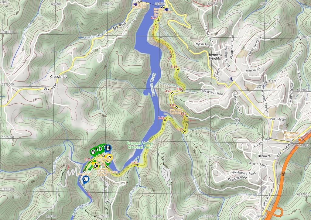
1 Crosslands to Berowra Waters return 6 hrs Hard track 13.7 km Return m This return walk starts from the Crosslands Reserve and follows the Great North Walk along Berowra creek. The walk includes some boardwalks. After climbing up the side of the valley, the walk comes back down into Berowra Waters. Here you can enjoy lunch by Berowra Creek, at the Garden House restaurant, or catch the free car-ferry across the river to find the fish cafe. 178m 1m Berowra Valley National Park Maps, text & images are copyright wildwalks.com Thanks to OSM, NASA and others for data used to generate some map layers.

2 Crosslands Before You walk Crosslands Reserve is lovely and long mixed use picnic area, spanning along the edge of Berowra Creek. There are picnic tables, electric barbecues, toilets, car parking, a children's playground, garbage bins, camping area, toilets and town water. The southern part of Crosslands is managed by Hornsby Council and the northern half by the NPWS within the Berowra Valley National Park. The first inhabitants of this area were a subgroup of the Dharug people who enjoyed the sandstone caves, fish and abundant plant life in the area. It is now managed by Hornsby Shire Council, but in 1856 Matthew Charlton asked Burton Crossland to be caretaker on this area. Burton built a house and made a living by harvesting timber, growing fruit, fishing and boat-building. Bushwalking is fun and a wonderful way to enjoy our natural places. Sometimes things go bad, with a bit of planning you can increase your chance of having an ejoyable and safer walk. Before setting off on your walk check Crosslands North Picnic area The northern section of Crosslands is in Berowra Valley NP and is a less formal picnic area compared with the southern area. There is a toilet block and a few sandy beaches with direct access to the water. Here you will find a few picnic tables and shelters, as well as garbage bins. The eastern side is home to a boardwalk exploring the estuarine wetland. A pleasant area to rest and enjoy the water. Fires are only permitted in formally established fire places. Berowra Creek (Estuarie) Lookout The Estuarie lookout over Berowara Creek is found at the end of the wheelchair-accessible walk in Crosslands area. The timber lookout platform provides views great views over Berowra Creek, the timber fence is 95cm high. There are also information signs about the local flora and fauna and the 'Original Inhabitants'. There are two timber bench seats encouraging you to take some time to soak up this view. Naa Badu Lookout Naa Badu Lookout offers magnificent views south over Berowra Creek as well as over Sams and Calna Creeks. Naa Badu means 'See water' in the Aboriginal tribal language of the Dharug people. It is believed that Berowra Creek was the boundary between the Dharug and Guringai Aboriginal peoples. The lookout is fenced, has a bench seat, picnic table and a fair amount of natural shade. Berowra Waters Garden House #######CLOSED###### This picturesque little restaurant sits on the eastern side of Berowra Creek and is just a hop, skip and a jump from the ferry. With breakfast, lunch and dinner menus, the Garden House Restaurant is a great spot for those looking to tap into the Berowra Valley's full potential. For information on bookings and opening hours phone (02) ) Weather Forecast (BOM Metropolitan District) 2) Fire Dangers (Greater Sydney Region) 3) Park Alerts (Berowra Valley National Park) 4) Research the walk to check your party has the skills, fitness and equipment required 5) Agree to stay as a group and not leave anyone to walk solo Think before you TREK The 'Think before you TREK' program developed by NSW Police & NPWS promotes the benefits of planning ahead for your bushwalking trip by using an easy to remember acronym: adequate supplies of food, water, navigation and first T Take aid equipment. your planned route and tell friends and family when R Register you expect to return. beacon (PLB's) should be carried on walks with E Emergency significant gaps in mobile coverage (check terrain profile). to your planned route and follow the map and walking K Keep trails. Topo Maps The maps provided on wildwalks are helpful, but there are times where you may need maps covering a broader area. Maps that cover this walk include; 1: Map Series:91304S HORNSBY, 91304N COWAN 1: Map Series:CMA Ku-ring-gai Chase National Park Tourist Map 1: Map Series:9130 SYDNEY Grade This walk has been graded using the AS The overall grade of the walk is dertermined by the highest classification along the whole track. 4 Grade 4/6 Hard track Length 13.7 km Return Time 6 hrs Quality of track Rough track, where fallen trees and other obstacles are likely (4/6) Signs Directional signs along the way (3/6) Experience Required Moderate level of bushwalking experience recommended (4/6) Weather Weather generally has little impact on safety (1/6) Infrastructure Limited facilities, not all cliffs are fenced (3/6)
3 Are you ready to have fun? Please ensure you and your group are well prepared and equipped for all possible hazards and delays. Check park closures, weather information and Fire Danger Rating before setting out. Optional side trips and alternate routes noted are not included in this walks overall grade, length or time estimate. Please allow extra time for resting and exploring areas of interest. The authors, staff and owners of wildwalks take care in preparing this information but will not accept responsibility for any inconvenience, loss or injury you may experience. Please take care, have fun - Happy Walking. Getting there Traveling by car is the only practical way to get to Crosslands Carpark (gps: , ). Car: There is free parking available. This is a return, so you will finish back at the start. Find up to date and more information inlcuding; travel directions, weather, park closures and walker feedback at 0 Crosslands Crosslands Reserve is lovely and long mixed use picnic area, spanning along the edge of Berowra Creek. There are picnic tables, electric barbecues, toilets, car parking, a children's playground, garbage bins, camping area, toilets and town water. The southern part of Crosslands is managed by Hornsby Council and the northern half by the NPWS within the Berowra Valley National Park. The first inhabitants of this area were a subgroup of the Dharug people who enjoyed the sandstone caves, fish and abundant plant life in the area. It is now managed by Hornsby Shire Council, but in 1856 Matthew Charlton asked Burton Crossland to be caretaker on this area. Burton built a house and made a living by harvesting timber, growing fruit, fishing and boat-building. 0 Crosslands Carpark (250 m ) From the car park, this walk follows the flat dirt path between the road (on the right) and creek (on the left). The path leads through the casuarina trees for about 120m to pass the boat ramp. After another 120m this walk comes to a locked gate at the northern end of the car park. There is also a wetland through the trees to the right worth noticing Northern end of Crosslands Carpark (260 m ) Continue straight: From the northern end of Crosslands car park (at the far northern end of Somerville Rd, Hornsby Heights), this walk follows the 'Newcastle' arrow on the large 'Great North Walk' sign around the locked gate and along the sealed old road. The walk continues along the old road for just over 150m passing 4 picnic tables to come to a y-intersection. At the intersection this walk veers right, past the 'Place of Winds' sign and wetland (on your right). This walk continues along this old road for a little longer, coming to an intersection marked with a large 'Crosslands' information board and 'Great North walk' sign. This is just on the edge of the northern picnic area, not far from the toilet block Crosslands North Picnic area The northern section of Crosslands is in Berowra Valley NP and is a less formal picnic area compared with the southern area. There is a toilet block and a few sandy beaches with direct access to the water. Here you will find a few picnic tables and shelters, as well as garbage bins. The eastern side is home to a boardwalk exploring the estuarine wetland. A pleasant area to rest and enjoy the water. Fires are only permitted in formally established fire places Crosslands North (220 m ) Turn right: From the intersection at the northern picnic area, this walk follows the 'Great North Walk' sign along the timber boardwalk. The timber boardwalks winds through the mangroves for about 60m, coming to a firm dirt track which leads for another 70m to a second timber boardwalk. The second boardwalk leads for another 70m, past 'Mangrove Food Cycle' information signs to come to an 3-way intersection in the boardwalk with the estuaries viewing platform boardwalk (on your left) Berowra Creek (Estuarie) Lookout The Estuarie lookout over Berowara Creek is found at the end of the wheelchair-accessible walk in Crosslands area. The timber lookout platform provides views great views over Berowra Creek, the timber fence is 95cm high. There are also information signs about the local flora and fauna and the 'Original Inhabitants'. There are two timber bench seats encouraging you to take some time to soak up this view Estuaries viewing platform (780 m 20 mins) Continue straight: From the intersection at the estuaries viewing platform, this walk follows the timber ramp down to the dirt track and heads past the '..unsuitable for wheelchair access' sign. The track leads alongside the wide creek for about 200m to the 'All creatures great and small' information sign, then down a little way further to head along a short section of timber boardwalk. About 100m further along the rocky track, this walk comes to a lookout and a 'Catch the Threats' information sign, where the track continues past the bench seat and alongside the creek to the 'The Rock Club' information sign. The track then leads among some grass tress for just over 100m to the 'Bush Supermarket' information sign. Just past this sign, the track begins to climb fairly steeply up the stone and timber steps to the ridge line, marked with a GNW arrow and a 'Stop! Look! Listen! and Smell!' information sign. Continue straight: From the ridge line, this walk follows the GNW arrow east downhill, initially keeping the 'Stop! Look! Listen! and Smell!' information sign on your right. The track bends left and follows the timber steps as the track winds steeply down the side of the hill. Near the bottom of the hill, the track passes a 'Rock n Roll' information sign then comes to a long, metal footbridge. The walk crosses the bridge over Calna Creek and comes to a signposted intersection, with a 'Fragile Marsh' information sign 1.51 Calna Creek Bridge intersection (1.1 km 27 mins) Veer left: From the intersection, this walk follows the 'Berowra Waters' sign along the timber boardwalk. The boardwalk leads for about 80m across the large open flat saltmarsh into the casuarina forest on the other side. Here the track bends left and leads along the side of the saltmarsh for almost 200m, where the rocky track leads a little further before coming alongside Berowra Creek's mangroves. The track continues to gently undulate along the side of Berowra Creek for about 650m among the casuarinas and grass tress, before heading up a fairly short, steep climb. At the top of this climb, the walk comes to a small, flat, pleasant clearing surrounded by large boulders Sams Creek ridge clearing (500 m 11 mins) Continue straight: From the clearing, this walk leads down the north eastern side of this ridge, keeping the main valley to your left. After about 100m this walk comes to another flat saltmarsh, where the track bends right to soon come to a large flat clearing beside Sams Creek (subject to flooding). The track then leads alongside Sams Creek (on your left) for about 350m when, just after climbing over a rock, the track comes to a 'Crosslands' sign pointing back along the track, beside the creek Sams Creek Crossing (670 m 30 mins) Turn left: From the south side of the creek, this walk follows the 'Berowra Waters' sign across the rocky Sams Creek. This creek may become impassable after heavy or prolonged rain. On the other side, the track veers left, crossing a rocky gully and heads up the timber steps. The track now starts to climb steeply, zigzagging up the timber steps and a couple of staircases for just over 300m to find a bench seat in a small sandstone cave. After a rest, this walk continues up more steps (and staircases) for just over 150m, coming to a T-intersection with a wide service trail, where a 'Crosslands' sign points back down the track Int of GNW and Berowra Link tracks (260 m 7 mins) Turn left: From the intersection, this walk follows the 'Berowra Waters' sign gently down along the management trail, keeping the valley to your left. The trail gently undulates along the side of the hill, enjoying some glimpses up to the cliff faces (on the right). After about 180m, the trail crosses a concrete drain, then leads up the hill to find the signposted 'Naa Badu' lookout and its great view Naa Badu Lookout Naa Badu Lookout offers magnificent views south over Berowra Creek as well as over Sams and Calna Creeks. Naa Badu means 'See water' in the Aboriginal tribal language of the Dharug people. It is believed that Berowra Creek was the boundary between the Dharug and Guringai Aboriginal peoples. The lookout is fenced, has a bench seat, picnic table and a fair amount of natural shade Int of Naa Badu Lookout (320 m 7 mins) Continue straight: From the 'Naa Badu' lookout, this walk follows the management trail over the small rise and across the concrete ditch, keeping the valley to your left. The trail leads around the side of the hill for about 300m, gently undulating to come to an intersection with a narrow track and small clearing (on your left, as the trail bends right), just past the large scribbly gum. (This informal track leads down to an unfenced rock platform, with filtered views over Berowra Creek) Int of GNW and Banggarai Creek access track (220 m ) Continue straight: From the intersection, the walk follows the wide trail gently downhill as it bends right, keeping the valley to your left. After about 140m, the trail narrows a bit, leading down a few short but steeper sections to an intersection (with some steps on your left), where a 'The Great North Walk' sign points back up along the trail Int of GNW and Berkeley Close service trail (570 m 18 mins) Turn left: From the intersection, the walk follows the 'Berowra Waters' sign down the timber steps. The walk then crosses Banggarai Creek using a timber bridge, and leads up some timber steps. The rocky track then leads up some more timbers steps, between two rocks then over a few rocks, where the track then flattens out. The now flat, sandy track winds through the forest for about 150m and passes a timber seat, then leads down across a small gully before the track begins to climb again. The track leads up some more timber steps, then the walk climbs two metal pegs in the rock and continues to climb steeply up the rock and timber steps. After 60m, the track flattens out again, leading gently up through the scribbly gum and angophora forest for just over 100m to a three-way intersection marked with a couple of GNW arrow posts. 5.2 Int of GNW and Currawong Road track (1.3 km 33 mins) Turn left : From the intersection, this walk follows the GNW arrow post north-west down the sandy track, directly towards the valley. The track soon becomes rocky and leads fairly steeply down the hill for about 150m before mostly flattening out and coming close to the top of an unfenced cliff with good views over Berowra Creek. Here the rocky track continues more gently down along the top of the ridge for about 200m and comes to a large rock platform. This walk veers right to lead down the gap in the rock, climbing down some steel pegs to where the track flattens out again. The track leads across the saddle for about 60m then veers left and follows

4 along the base of a long rock wall (on your right). Here the track leads down around the side of the ridge for just over 400m, passing some unfenced views for rock platforms then down some sandstone steps to find a tall sandstone overhang with a timber seat. From this cave, this walk continues along the base of the rock wall, and soon bends left and winds fairly steeply down a series of rock and timber steps to come to the edge of Berowra Creek (where there is a 'no wash' sign facing the water from the rock platform). The track leads along the shore line for a short time to head onto the rock platform in Washtub Gully Washtub Gully Creek (320 m 9 mins) Continue straight: From Washtub Gully, this walk crosses the creek and follows the track, keeping Berowra Creek not far to your left. After about 50m, the track passes an old partially sunken boat, then about 100m further on, the track passes a view point that is an obviously popular (but not recommended) jumping spot. The track then soon leads up some steps and over a rise behind the 'Berowra Waters Garden House' restaurant, then heads down the steps to come to the signposted 'Berowra Waters Trackhead' on 'Berowra Waters Rd' Berowra Waters Garden House #######CLOSED###### This picturesque little restaurant sits on the eastern side of Berowra Creek and is just a hop, skip and a jump from the ferry. With breakfast, lunch and dinner menus, the Garden House Restaurant is a great spot for those looking to tap into the Berowra Valley's full potential. For information on bookings and opening hours phone (02) The Fish Café This seafood restaurant is located on the western side of the Berowra Waters Ferry, and offers casual dining with a great menu, overlooking the marina and river. The restaurant is open 7 days a week for breakfast and lunch, with dinner available on Friday through Sunday. The cafe is open 8:30 9pm WedSun and closes at 3pm Mon & Tuesdays. Takeaway is also available, and the nearby reserve provides picnic tables, toilets, children's playground and parking. Kayak hire is available from the marina building. The Fish Café is located at 199 Bay Road, Berowra Waters, and the phone number is (02) Waterview Restaurant On the western side of Berowra Waters Ferry (free trip), just a short walk up the road, is the Waterview Restaurant, upstairs at the marina. The restaurant specialises in seafood, but also caters for other tastes in restaurant style dinning. Some sittings offers A la Carte meals from $25, and other sittings offer a fresh and cooked seafood buffet. Please call ahead, as the restaurant is also a popular venue for weddings. Open Friday-Sunday for lunch and dinner. Phone (02) Bay Rd Berowra Waters, NSW 2082
5
6 Summary navigation sheet for the Crosslands to Berowra Waters return km Powered by TCPDF ( From Up/Dwn Length Initial directions (Use full tracknotes and maps for more detail) Start Crosslands Carpark , (GR Hornsby, ) 0.25 Northern end of Crosslands Carpark , (GR Hornsby, ) 0.51 Crosslands North , (GR Hornsby, ) 0.73 Estuaries viewing platform , (GR Hornsby, ) 1.51 Calna Creek Bridge intersection , (GR Hornsby, ) 2.66 Sams Creek ridge clearing , (GR Cowan, ) 3.16 Sams Creek Crossing , (GR Cowan, ) 3.83 Int of Great North Walk and Berowra Link tracks , (GR Cowan, ) 4.09 Int of Naa Badu Lookout , (GR Cowan, ) 4.41 Int of Great North Walk and Banggarai Creek access track , (GR Cowan, ) m 260 m 220 m 780 m 20 mins 1.1 km 27 mins 500 m 11 mins 670 m 30 mins 260 m 7 mins 320 m 7 mins 220 m From the car park, this walk follows the flat dirt path between the road (on the right) and creek (on the left) Int of Great North Walk and Berkeley Close service trail , (GR Cowan, ) m 18 mins Turn left: From the intersection, the walk follows the 'Berowra Waters' sign down the timber steps Int of Great North Walk and Currawong Road track , (GR Cowan, ) km 33 mins Turn left : From the intersection, this walk follows the GNW arrow post north-west down the sandy track, directly towards the valley Washtub Gully Creek , (GR Cowan, ) m 9 mins Continue straight: From Washtub Gully, this walk crosses the creek and follows the track, keeping Berowra Creek not far to your left. Continue straight: From the northern end of Crosslands car park (at the far northern end of Somerville Rd, Hornsby Heights), this walk follows the 'Newcastle' arrow on the large 'Great North Walk' sign around the lo... Turn right: From the intersection at the northern picnic area, this walk follows the 'Great North Walk' sign along the timber boardwalk. Continue straight: From the intersection at the estuaries viewing platform, this walk follows the timber ramp down to the dirt track and heads past the '..unsuitable for wheelchair access' sign. Veer left: From the intersection, this walk follows the 'Berowra Waters' sign along the timber boardwalk. Continue straight: From the clearing, this walk leads down the north eastern side of this ridge, keeping the main valley to your left. Turn left: From the south side of the creek, this walk follows the 'Berowra Waters' sign across the rocky Sams Creek. Turn left: From the intersection, this walk follows the 'Berowra Waters' sign gently down along the management trail, keeping the valley to your left. Continue straight: From the 'Naa Badu' lookout, this walk follows the management trail over the small rise and across the concrete ditch, keeping the valley to your left. Continue straight: From the intersection, the walk follows the wide trail gently downhill as it bends right, keeping the valley to your left.
Crosslands to Cowan. 220m
 Crosslands to Cowan 7 hrs 30 mins 14 km One way Hard track 4 1103m This section of the Great North Walk starts from the Crosslands camping area and winds north alongside Berowra creek, passing through
Berowra Waters to Cowan Station
 Berowra Waters to Cowan Station 3 hrs 30 mins 7.2 km One way Hard track 597m This is a hilly walk out of the beautiful Berowra Waters valley to Cowan Station. There are many wide views across Berowra Creek
Berowra to Cowan via Berowra Waters
 Berowra to Cowan via Berowra Waters 6 hrs Hard track 12.9 km One way 4 884m With train station at each end this walk explores the ridges and valleys around Berowra Waters. There are plenty of excellent
Mt Kuring-gai Track to Berowra station
 Mt Kuring-gai Track to Berowra station 4 hrs 15 mins 9.7 km One way Hard track 4 553m This walk explores three valleys, with great displays of wild flowers in spring, and some nice sandstone overhangs.
Crosslands to Brooklyn
 Crosslands to Brooklyn 2 Days Hard track 27.4 km One way 4 1757m From the Crosslands Reserve, this walk heads along the Great North Walk via Berowra Waters, Cowan, Jerusalem Bay and onto Brooklyn. This
Congewai Track Head (East) to Watagan Headquarters
 to Watagan Headquarters") Congewai Track Head (East) to Watagan Headquarters 7 hrs Hard track 17.2 km One way 4 973m This full day walk starts from the Congewai valley trackhead (east) and follows the Great North Walk up into the
Congewai Track Head (East) to Watagan Headquarters 7 hrs Hard track 17.2 km One way 4 973m This full day walk starts from the Congewai valley trackhead (east) and follows the Great North Walk up into the
Berowra to Hornsby. 9 hrs 18 mins 22.6 km One way. Hard track. 1423m
 Berowra to Hornsby 9 hrs 18 mins 22.6 km One way Hard track 4 1423m One of the longer day walks in Berowra Valley National Park, this walk mostly follows Berowra Creek along the Great North Walk. Excellent
Nature Track. 900m. 789m. 2 hrs 3.1 km Circuit. Hard track 238m. Blue Mountains National Park
 Nature Track 2 hrs 3.1 km Circuit Hard track 238m Largely following the ridges around the top edge of Wentworth Falls, this track is incredibly beautiful. After taking in the great views at Edinburgh Castle
Leura Cascades to Gordon Falls Reserve
 Leura Cascades to Gordon Falls Reserve 1 hr 15 mins 1.8 km One way Moderate track 200m From Leura Park to Gordon Falls Park, this diverse walk offers fantastic views of the Jamison Valley, as well as two
Girrakool to Wondabyne station
 Girrakool to Wondabyne station 4 hrs Hard track 9.5 km One way 4 438m This walk starts from the Girrakool picnic area and winds south, through the Brisbane Waters National Park. The walk crosses some long
Merritts Traverse. 1928m
 Merritts Traverse 3 hrs Hard track 5.8 km Circuit 4 167m This walk starts with a scenic journey to the top of the hill on the chairlift. Starting along Merritts Nature walk, this walk soon detours down
Staples Lookout to Mt Wondabyne loop
 Staples Lookout to Mt Wondabyne loop 4 hrs 3 mins 1.8 km Circuit Hard track 337m This walk starts and finishes at Staples Lookout, on Woy Woy Rd. The walk follows sections of the Great North Walk around
Erskine Creek via Pisgah Rock and Jack Evans
 Erskine Creek via Pisgah Rock and Jack Evans 4 hrs 30 mins 7.1 km Circuit Very experienced only 6 421m This walk visits some great lookouts and explores the lower section of Erskine Creek. Most of the
Hornsby station to Crosslands
 Hornsby station to Crosslands 6 hrs 45 mins 16.1 km One way Hard track 4 938m This section of the Great North Walk starts from Hornsby train station and winds down along the Blue Gum Walk into Fishponds.
Gibberagong Track. 169m
 Gibberagong Track 2 hrs 30 mins 6.5 km One way Hard track 4 180m Starting in suburban Wahroonga, this wellmaintained track follows Cockle Creek down to Bobbin Head in the Ku-ring-gai Chase National Park.
Abbotts Falls Walking Track
 Abbotts Falls Walking Track 3 hrs 7.3 km Circuit Hard track 329m This circuit takes you through both dry and moist forest, using a combination of walking trails and wider tracks. The side trip to the dammed
Victoria Falls Lookout to Blue Gum Forest
 Victoria Falls Lookout to Blue Gum Forest 8 hrs Experienced only 13.8 km One way 5 112m This long day-walk follows a remote track down from Victoria Falls lookout, passing the waterfall, and into the Grose
Jerusalem Bay Track (Cowan to Brooklyn)
") Jerusalem Bay Track (Cowan to Brooklyn) 5 hrs 30 mins 13.4 km One way Hard track 4 654m This Cowan to Brooklyn Station walk is a popular section of the Great North Walk, with scenery ranging from foreshore
Jerusalem Bay Track (Cowan to Brooklyn) 5 hrs 30 mins 13.4 km One way Hard track 4 654m This Cowan to Brooklyn Station walk is a popular section of the Great North Walk, with scenery ranging from foreshore
Guthega to Mt Twynam. 2183m. 1583m. 6 hrs 45 mins 14.8 km Return. Experienced only. 913m
 Guthega to Mt Twynam 6 hrs 45 mins 14.8 km Return Experienced only 5 913m This walk starts from Guthega and makes its way along the Snowy River to the Illawong Lodge, via the Blue Cow Creek flying fox.
National Pass. 893m. 665m. 3 hrs 30 mins 4.6 km Circuit. Hard track 773m. Blue Mountains National Park
 National Pass 3 hrs 3 mins 4.6 km Circuit Hard track 773m 4 This walk offers fantastic views of the Jamison Valley and the surrounding cliffs. Take time to explore the historic and very scenic ledge halfway
Girrakool to Wondabyne station via Pindar caves
 Girrakool to Wondabyne station via Pindar caves 7 hrs 30 mins 18.1 km One way Experienced only 5 741m This walk starts from the Girrakool picnic area and winds south, following Piles creek into the Brisbane
Thornleigh to Cowan. 2 Days. Hard track 35.9 km One way. 2337m
 Thornleigh to Cowan 2 Days Hard track 35.9 km One way 4 2337m Following the Great North Walk and Berowra Creek through Berowra Valley Regional Park, this walk cuts straight through the length of the Park.
Wentworth Pass. 893m. 535m. 4 hrs. Hard track 5.1 km Circuit. 692m
 Wentworth Pass 4 hrs Hard track 5.1 km Circuit 4 692m This walk offers a great way to explore the magical, upper section of the Valley of the Waters. The walk starts and finishes at Conservation Hut, which
Dadder Cave and Jack Evans track
 Dadder Cave and Jack Evans track 2 Days 10.3 km Circuit Very experienced only 535m This fairly short overnight walk is a great way to explore Erskine Creek. The walking along Erskine creek is mostly off
Scenic Railway to Ruined Castle
 Scenic Railway to Ruined Castle 7 hrs 30 mins 12.4 km Return Hard track 4 963m This is a very popular, full day walk, in the Katoomba Area, offering great views of the valley. The walk follows the edge
Patonga to Staples Lookout
 Patonga to Staples Lookout 6 hrs 3 mins 17 km One way Hard track 4 72m This great walk explores much of the main ridge ridge running through Brisbane Water National Park. The walk visits a number of great
Patonga to Wondabyne station via Mt Wondabyne
 Patonga to Wondabyne station via Mt Wondabyne 7 hrs 3 mins 19.5 km One way Hard track 4 861m This walk explores some grand views, pleasant cascades, varied bushland and remote areas of Brisbane Waters
Somersby to Yarramalong via Stringy Bark Point
 Somersby to Yarramalong via Stringy Bark Point 2 Days Hard track 26.7 km One way 4 1201m This section of the Great North Walk starts form the Somersby General Store and follows the Great North Walk north
Wondabyne station to Somersby Store
 Wondabyne station to Somersby Store 10 hrs Hard track 26.2 km One way 4 1164m This walk, following a section of the Great North Walk, starts from the Wondabyne train station and winds north, into the Brisbane
Lady Carrington Drive
 Lady Carrington Drive 3 hrs 45 mins 9.7 km One way Moderate track 3 266m This walk follows the historic Lady Carrington Drive alongside the Hacking River. The old road is closed to traffic and provides
Victoria Falls to Blackheath Station
 Victoria Falls to Blackheath Station 2 Days Experienced only 22.2 km One way 5 1561m This is a fantastic overnight walk with a sleep in Acacia Flats camping area. The Grose Valley, with its views of the
Leura to Katoomba via Dardanelles Pass
 Leura to Katoomba via Dardanelles Pass 4 hrs 6.6 km One way Hard track 697m With approximately equal parts cliff-walk and forest track, this track truly shows what the cliff edges of the Jamison Valley
Victoria Falls and Grose Valley to Blackheath Station
 Victoria Falls and Grose Valley to Blackheath Station 3 Days Experienced only 22.5 km One way 5 158m This walk explores a fantastic section of the Grose Valley. Starting above Victoria Falls, the walk
Somersby to the Basin Campsite
 Somersby to the Basin Campsite 3 Days Hard track 47.4 km One way 4 2032m This three day walk starts at the Somersby General Store and follows the Great North Walk, heading north, into the the Jilliby State
Main Range Track - Loop from Charlotte Pass camping near Mt Townsend
 Main Range Track - Loop from Charlotte Pass camping near Mt Townsend 2 Days Experienced only 27.7 km Circuit 5 1260m This great overnight walk starts from Charlotte Pass and provides access to some of
Patonga to Wondabyne station via Pindar Caves overnight
 Patonga to Wondabyne station via Pindar Caves overnight 2 Days Experienced only 28.1 km One way 5 1164m This overnight hike starts from Patonga beach and winds along a section of the Great North Walk,
The Prince Henry Cliff Walk
 The Prince Henry Cliff Walk 3 hrs 30 mins 6.8 km One way Moderate track 3 575m Going from Katoomba to Leura, this walk covers the top of the cliff line and most of the major lookouts. With brilliant vistas
Main Range Walk - Charlotte Pass to Mount Kosciuszko
 Main Range Walk - Charlotte Pass to Mount Kosciuszko 9 hrs Hard track 21.9 km Circuit 4 920m This full day walk explores some of the greatest alpine country on offer in NSW. The walk grants views of Blue,
Cowan to Wondabyne station via Patonga rest area
 Cowan to Wondabyne station via Patonga rest area 2 Days Hard track 33.4 km One way 4 1523m This section of the Great North Walk starts from Cowan train station and wanders past the majestic Jerusalem Bay
Blackheath to Blue Gum loop
 Blackheath to Blue Gum loop 2 Days Hard track 24.1 km Circuit 4 1335m This walk is great for fit people getting into overnight walking, with its fantastic scenery and nostalgia as a classic overnighter.
Katoomba to Wentworth Falls via the Jamison Valley
 Katoomba to Wentworth Falls via the Jamison Valley 2 Days Experienced only 29.2 km One way 5 2135m This is the two day version of this popular and challenging walk. This walk passes popular sights including
Gordon to Hornsby (overnight at Scout camp)
") Gordon to Hornsby (overnight at Scout camp) 2 Days Hard track 25.8 km One way 4 125m This overnight walk starts from Gordon train station and winds through bush filled valleys to Hornsby station. From
Gordon to Hornsby (overnight at Scout camp) 2 Days Hard track 25.8 km One way 4 125m This overnight walk starts from Gordon train station and winds through bush filled valleys to Hornsby station. From
Guthega to Thredbo camping overnight at Wilkensons Creek
 Guthega to Thredbo camping overnight at Wilkensons Creek 2 Days Experienced only 25.8 km One way 5 1364m This great overnight walk explores the Kosciusko National Park between Guthega and Thredbo, visiting
COLOUR G U I D E. Sydney to Newcastle: Australia s most accessible long-distance walk
 COLOUR G U I D E Sydney to Newcastle: Australia s most accessible long-distance walk Woodslane Press Pty Ltd Unit 7/5 Vuko Place Warriewood, NSW 2102 Australia Email: info@woodslane.com.au Tel: (02)
Western Commission Track to Dubbo Gully
 This two day walk follows a series of historic roads along clear and wide management trails. This walk explores the great views from Western Commission Track, the sandstone handicraft on the Old Great
Victoria Falls and Grose Valley to Blackheath Station
 This walk explores a fantastic section of the Grose Valley. Starting above Victoria Falls, the walk explores the cascades before dropping into the valley for the first nights rest at Burra Korain campsite.
Main Range Circuit from Guthega
 Main Range Circuit from Guthega 4 Days Experienced only 45 km Circuit 5 2317m This four day walk explores the Kosciuszko National Park, covering many of the key features of the park between Guthega and
Out and about at Geehi
 Geehi Geehi Flats is a large area of flat floodplain on the banks of the Swampy Plains River. Located within Kosciuszko National Park, it is home to a popular campsite in summer for people wanting to enjoy
Illawarra Escarpment State Conservation Area Walking Tracks
 Illawarra Escarpment State Conservation Area Walking Tracks NPWS Illawarra Area Office Ground Floor, Government Office Block 84 Crown Street Wollongong NSW 2500 02 4223 3000 (Mon-Fri) Royal National Park
The Mendip Way. Route Directions and Maps Uphill to Wells
 The Mendip Way Route Directions and Maps Uphill to Wells Website: www.mendiphillsaonb.org.uk Email: mendip@mendiphillsaonb.org.uk Facebook & Twitter: @MendipHillsAONB Phone: 01761462338 1 Uphill to Loxton
Hindhead, Keffolds Copse and Gibbet Hill
 point your feet on a new path, Keffolds Copse and Gibbet Hill Distance: 6 km=4 miles Region: Surrey Author: Schwebefuss Refreshments: Punch Bowl Café moderate walking Date written: 14-apr-2015 Last update:
Printed in China by Designed by Coral Lee Main cover image: Broken Bay
 Woodslane Press Pty Ltd Unit 7/5 Vuko Place Warriewood, NSW 2102 Australia Email: info@woodslane.com.au Tel: (02) 9970 5111 Fax: (02) 9970 5002 http://travelandoutdoor.bookcentre.com.au First published
Premium Waterfront Land for Sale
 Premium Waterfront Land for Sale An opportunity has arisen for the astute investor to purchase one of the last remaining blocks of absolute waterfront land at Berowra Waters. Lot 3 Coba point features
Discover. Ashhurst Domain. Nature s Playground
 Discover Ashhurst Domain Nature s Playground Discover Step back into New Zealand, Aotearoa, of generations long gone. Discover lush natural surrounds echoing with rich birdsong in one of the Manawatu s
Leaden Boot Challenge ROUTE INSTRUCTIONS
 Leaden Boot Challenge ROUTE INSTRUCTIONS Section 1 Alstonefield to Ilam From the village hall car park turn R then L and pass through the village keeping to the R to enter Church Street. Pass the Church
GOLDEN EARS PROVINCIAL PARK
 GOLDEN EARS PROVINCIAL PARK Trail Information as of October 10 th 2015 Do not underestimate the mountainous wilderness of Golden Ears Provincial Park. The combination of rugged terrain and rapidly changing
Leaden Boot Challenge 2016 ROUTE INSTRUCTIONS
 Leaden Boot Challenge 2016 ROUTE INSTRUCTIONS Section 1 Alstonefield to Ilam (CP2) From the village hall car park turn R then L and pass through the village keeping to the R to enter Church Street. Pass
Tiger Mountain State Forest:
 98 60 hikes within 60 miles: SEATTLE 20 Tiger Mountain State Forest: West Tiger Mountain Three Loop i KEY AT-A-GLANCE INFORMATION Length: 5.1 miles round-trip Configuration: Loop Difficulty: Moderate difficult
OCTOBER. MONDAY 2 nd QUEENS BIRTHDAY HOLIDAY
 OCTOBER MONDAY 2 nd QUEENS BIRTHDAY HOLIDAY TUESDAY 3 rd 8 am - WINDSOR, NEWMARKET TO ASHGROVE - Visit Northey Street City Farm, a community-managed enterprise that produces fruit, vegetables and herbs
Little Grand Canyon near Pomona, Illinois
 Little Grand Canyon near Pomona, Illinois Below: View of the trail and the terrain created using the Map My Hike app Below: Summary of the hike created using the Map My Hike app Presented by: Jennifer
Kakadu Highlights No. 9: September 23 - October 6, 2018
 Kakadu Highlights No. 9: September 23 - October 6, 2018 Section 1: Barramundi Creek: September 23-26 We begin with a four to six hour, 350 kilometre drive from Darwin. The last 45 kilometres is on a 4WD
Access Statement for RSPB South Stack Cliffs
 Introduction This access statement does not contain personal opinions as to our suitability for those with access needs, but aims to accurately describe the facilities and services that we offer all our
Difficult Run Stream Valley Park
 Difficult Run Stream Valley Park The more intense mountain bikers have known about for Difficult Run for some time. Equestrians have known it longer. Eight miles of unpaved trail, the Rails to River Trail
Trail Phasing Plan. Note: Trails in the Clear Creek Canyon area (Segments will be finalized in the future to minimize wildlife impacts
 Note: Trails in the Clear Creek Canyon area (Segments 2 5 and a future JCOS connection) will be finalized in the future to minimize wildlife impacts Trail Phasing Plan P Parking 3 Easy Trail Intermediate
Slad over to Pitchcombe and back
 The walk climbs up from Slad over Wickridge Hill, descends to near Pitchcombe, then climbs back over Wickridge hill and round the back of Slad. Page 1 Start Point: SO 8718 0732 The Woolpack, Slad Length:
Hadleigh Castle and Chalkwell Oaze
 1 Hadleigh Castle and Chalkwell Oaze Benfleet station Hadleigh Park Hadleigh Castle Leigh-on-Sea Chalkwell station A short stroll through the lush woods of Hadleigh Park high above the Thames-side marshes,
CWMGIEDD FROM ABERCRAVE
 Abercrave to Cwmgiedd Walk Page 1 Starting from The Abercrave Inn. Grid Ref: SN 824128 From the Abercrave Inn, an 11.3km (7 miles) walk to the foothills of the Cribarth Mountain, then through forest to
Walking Track Classification System Parks and Wildlife Service
 Appendix A Walking Track Classification Specifications Walking Track Classification System Parks and Wildlife Service This Walking Track Classification System is the outcome of a review of the track classifications
Beautiful Walks from the Blue Ball Inn
 Walk No. 5 RIVER VALLEYS AND MOOR Countisbury, Watersmeet, Hillsford Bridge, Cheriton, Shilstone Hill, Rockford and Chiselcombe. 8.5 MILES APPROX. Walking time four and a half hours approx. OS 1;25,000
Lake Wissota Access Locations within the LaFayette Township. By Chad Martin
 Lake Wissota Access Locations within the LaFayette Township By Chad Martin Anson/ Wissota Access Point # 1 Road: 195 th St. Associated Fire Numbers: 13294 Defining Characteristics: Forested from road
1. Waterfall Gully Mt Lofty. 5 Of the Best Hikes in Adelaide
 Adelaide is a beautiful city, and one of the most incredible things about Adelaide is the quality of bushwalking available on the suburban fringe. It is surrounded by the Mt Lofty Ranges, and much of the
This path goes past an old tree nursery and sawmill. After 800m it crosses over a lane. Follow the bridleway fingerpost into the woods.
 FRENSHAM PONDS 11K CIRCULAR TRAIL 2½ HRS GU10 2DA This magnificent heathland trail starts in woodland and then brings you out onto the open heather of Frensham Common, with no roadwork! The route runs
DAY 1: Circular Quay to Greenwich Wharf
 DAY 1: Circular Quay to Greenwich Wharf Total Distance: 14km Time: Approximately 5 hours Walk Notes in Six Sections Section Name Length Time 1:1 Circular Quay to Milsons Point Station 2.5km 50mins 1:2
Department of Environment, Climate Change & Water NSW. Stakeholder feedback
 Department of Environment, Climate Change & Water NSW Stakeholder feedback 1 Stakeholders group Blue Gum High Forest Group Guardians of Lane Cove NP Sydney Metropolitan Wildlife Service Ku-ring-gai Historical
Self-Guided Walk Langdale Pikes. Start & Finish: NT car park (free to members) at Sticklebarn - on the right just beyond the New Dungeon Ghyll hotel.
 at Sticklebarn - on the right just beyond the New Dungeon Ghyll hotel.") Self-Guided Walk Langdale Pikes Key Information These mountains form a collection of spires and cliffs on the north side of Langdale. This walk visits four of the main tops Pavey Ark, Harrison Stickle,
Self-Guided Walk Langdale Pikes Key Information These mountains form a collection of spires and cliffs on the north side of Langdale. This walk visits four of the main tops Pavey Ark, Harrison Stickle,
Baggy Point, Croyde, North Devon
 Baggy Point, Croyde, North Devon A walk using the South West Coast Path that is likely to be suitable for people with impaired mobility or with a pushchair, wheelchair, or mobility scooter. The Coast Path
Arches of the. Sandflats Area. By Virginia Allen
 Arches of the Sandflats Area By Virginia Allen TABLE OF CONTENTS Introduction Dedication Road Log Arches 1. Perforated View Arch 2. Fee Booth Arch 3. Windsong Arch 4. Weird Arch 5. Resting Arch 6. Bike
NOVEMBER WEDNESDAY 9 - TENERIFFE CIRCUIT
 NOVEMBER WEDNESDAY 1 st 9 am - TENERIFFE CIRCUIT This walk around the suburb of Teneriffe includes a track winding up through tall trees and vegetation to Teneriffe Park. Distance 7 km some uphill walking
Marilla Reservoir to Chestnut Ridge via Marilla Trails and Bullis Hollow Trail east to west
 USGS topographic maps useful to this hike are the Bradford and Stickney 7.5 minute sectionals. These notes are designed to assist in identifying distance and location using geophysical and man-made characteristics
CAMPSITE 411. Girl Scouts of Greater Atlanta, Inc.
 CAMPSITE 411 Girl Scouts of Greater Atlanta, Inc. What is provided for us at each campsite/cabin? Although each living unit (tents or cabins) is unique, you can expect to find certain unit equipment in
Access Statement for RSPB Lochwinnoch
 Introduction This access statement does not contain personal opinions as to our suitability for those with access needs, but aims to accurately describe the facilities and services that we offer all our
Prince Regent National Park
 Prince Regent National Park 23 rd June- 14 th July 2019 Garimbu Creek, Moran and Roe River Area Notes written by Cassie Newnes This area has something for everyone, magnificent scenery, stunning waterfalls,
Britain s oldest surviving water-balanced cliff lift
 44 3.6 Saltburn by the Sea to Sandsend Map panels 3 and 4 Distance 17 miles (27½ km) Terrain mostly grass and field paths which can be muddy; some pavement, beach and shore Grade undulating route, with
Singleton and the South Downs
 point your feet on a new path Singleton and the South Downs Distance: 13½ km=8½ miles easy walking with a few steeper sections Region: West Sussex Author: Hautboy Refreshments: Singleton, Hill Barn Date
Bewl Water & the High Weald
 1 Bewl Water & the High Weald Stonegate station - Stonegate - Wallcrouch - Newbarn - Cousley Wood - Wood's Green - Wadhurst station Length: 9 ½ miles (15.3km) Underfoot: Large portions of this path are
HARDMOORS ROUTE DESCRIPTION
 HARDMOORS 60 2016 ROUTE DESCRIPTION RACE START (GUISBOROUGH) - CHECKPOINT 2 (SALTBURN) DISTANCE 9 MILES CUT OFF TIME 1030 GRID REF OS 666 208 1. Leaving the Sea Cadets Hall, turn left onto the road and
event map book SYDNEY 50KM SYDNEY 100KM
 event map book SYDNEY 50KM SYDNEY 100KM SATURDAY 25 SUNDAY 26 AUGUST 2018 BOBBIN HEAD TO THE HARBOUR FRIDAY 24 SUNDAY 26 AUGUST 2018 THE HAWKESBURY TO THE HARBOUR NATIONAL PARTNERS WWW.OXFAM.ORG.AU/TRAILWALKER
San Miguel to Caserio de la Hoya Circular (San Miguel)
") Tenerife Sur: Short Walks Under 10 km San Miguel to Caserio de la Hoya Circular (San Miguel) Route Summary An informative and scenic walk back in time from San Miguel to below El Roque, overlooking the
Tenerife Sur: Short Walks Under 10 km San Miguel to Caserio de la Hoya Circular (San Miguel) Route Summary An informative and scenic walk back in time from San Miguel to below El Roque, overlooking the
TREK THE ROCKIES ABOUT THE CHALLENGE TREK THE ROCKIES FOR HIGHLAND HOSPICE CANADA TREK DEMANDING
 TREK THE ROCKIES CANADA TREK DEMANDING ABOUT THE CHALLENGE The Canadian Rockies are justifiably world-famous for their magnificent scenery: the combination of impressive, jagged mountains, bright turquoise
Kakadu Highlights No. 9: October 1-7, 2017 major revision 4 Sept 2017
 Kakadu Highlights No. 9: October 1-7, 2017 major revision 4 Sept 2017 We didn t get the bookings we needed to run the full trip so we ve shortened it to try and run at least an abbreviated version it for
King George Area: May 5-18, 2019
 King George Area: May 5-18, 2019 Section 1: Faraway Bay airstrip to Twin Falls: May 5-12 We fly to the Faraway Bay airstrip where we leave the food for the second section, don our packs and head toward
Our Murray River Beaches
 Page 1 of 5 Our Murray River Beaches Click here to print this page West of Yarrawonga are many access points to the river. Earth tracks lead from the Murray Valley Highway through state forests to picnic
Hiking Trail Descriptions
 Hiking Trail Descriptions For ye shall go out with joy. And be led forth with peace. The mountains and the hills shall break forth before you in singing. And all the trees of the fields shall clap their
Access Statement for Birling Gap
 This access statement does not contain personal opinions as to our suitability for those with access needs, but aims to accurately describe the facilities and services that we offer all our guests/visitors.
THURSDAY 9 - THORNTON STREET CIRCUIT
 FEBRUARY THURSDAY 1 st 9 am - THORNTON STREET CIRCUIT Walk beside the Kangaroo Point Cliffs and continue through South Bank returning along the top of the cliffs. Meet Thornton Street Ferry Terminal UBD
Access Statement for Radipole Lake
 This access statement does not contain personal opinions as to our suitability for those with access needs, but aims to accurately describe the facilities and services that we offer all our guests/visitors.
Central Coast Hunter Range Region Discovery Program
 Central Coast Hunter Range Region Discovery Program Sydney to Newcastle General Inquiries NPWS (02) 4320 4200 (Monday - Friday) Detailed Information Anne Whyte, Discovery Coordinator NPWS (02) 4320 4205
middle left: Riversleigh fossils lower left: Constance Range images: Hj Preuss... Thx
 Upstreampaddle Summer 2008 18 middle left: Riversleigh fossils lower left: Constance Range images: Hj Preuss... Thx top right: road west of the Isa middle right: Constance Range lower right: rocky outcrop
Camp Jack Wright PERMANENT ORIENTEERING COURSE (2004)
") Camp Jack Wright PERMANENT ORIENTEERING COURSE (2004) WHAT IS ORIENTEERING? The skill which enables a person to navigate with a map. In the competitive sport, the winner is the person who finishes in the
Camp Jack Wright PERMANENT ORIENTEERING COURSE (2004) WHAT IS ORIENTEERING? The skill which enables a person to navigate with a map. In the competitive sport, the winner is the person who finishes in the
HARDMOORS 55 RACE ROUTE 2018 HELMSLEY - GUISBOROUGH
 HARDMOORS 55 RACE ROUTE 2018 HELMSLEY - GUISBOROUGH HELMSLEY - CHECKPOINT 1 (WHITE HORSE) 1. Leave RACE START, continue ahead on road (Baxtons Sprunt) At crossroads turn right down Canons Garth eventualy