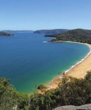
Printed in China by Designed by Coral Lee Main cover image: Broken Bay
|
|
|
- Nigel Hutchinson
- 6 years ago
- Views:
Transcription
1
2
3
 9970 5111 Fax: (02) 9970 5002 http://travelandoutdoor.bookcentre.com.")
4 Woodslane Press Pty Ltd Unit 7/5 Vuko Place Warriewood, NSW 2102 Australia Tel: (02) Fax: (02) First published in Australia in 2010 by Woodslane Press Copyright 2010 Woodslane Press Pty Ltd; text, photographs and histograms 2010 Matt McClelland and Wildwalks All rights reserved. Apart from any fair dealing for the purposes of study, research or review, as permitted under Australian copyright law, no part of this publication may be reproduced, distributed, or transmitted in any other form or by any means, including photocopying, recording, or other electronic or mechanical methods, without the prior written permission of the publisher. For permission requests, write to the publisher, addressed Attention: Permissions Coordinator, at the address above. Every effort has been made to obtain permissions relating to information reproduced in this publication. The information in this publication is based upon the current state of commercial and industry practice and the general circumstances as at the date of publication. No person shall rely on any of the contents of this publication and the publisher and the author expressly exclude all liability for direct and indirect loss suffered by any person resulting in any way from the use or reliance on this publication or any part of it. Any opinions and advice are offered solely in pursuance of the author s and publisher s intention to provide information, and have not been specifically sought. National Library of Australia Cataloguing-in-Publication entry McCelland, Matthew. Best bush & coastal walks of the Central Coast: the full-colour guide to 36 fantastic walks / Matthew McClelland. 1st ed (pbk.) Includes index. Hiking--New South Wales--Central Coast--Guidebooks. Walking--New South Wales--Central Coast--Guidebooks. Central Coast (N.S.W.)--Description and travel Printed in China by Designed by Coral Lee Main cover image: Broken Bay
5
6
7
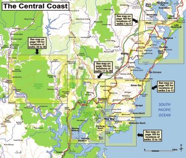
8 1 Munmorah Coastal one way 1 hr 30 mins Hard - Yes Wildflowers, coast views, Frazer Beach 2 Norah Head Lighthouse Loop circuit 1 hr Medium Nearby Yes Lighthouse, coast views, rock pool 3 Redgum Trail circuit 1 hr 15 mins Medium Angophora forest, Tuggerah Lake views 4 Lillypilly Loop Trail circuit 1 hr 15 mins Medium - Yes Tuggerah Lake shore, diverse forest 5 Wyrrabalong Coast Walking Track one way 1 hr 30 mins Medium Nearby Yes Coast Views, picnic areas, beaches 6 Ouraka Point Loop circuit 1 hr 15 mins Medium Nearby Ouraka Point Lookout, dry forests 7 Ironbark and Flannel Flower Circuit circuit 1 hr Medium Lookouts, varied forests, picnic areas 8 Rainforest walk to Nurrunga one way 1 hr Medium Varied forest, sculptures, lookouts, picnic area 9 Gosford to Lisarow one way 4 hrs 30 mins Medium Start District views, wildflowers, picnic areas 10 Katandra Reserve Explorer circuit 2 hrs 45 mins Medium Strangler Fig trees, Seymour Pond, lookout 11 Kincumber to Terrigal one way 2 hrs Medium Rock formations, picnic area, lookout 12 Box Head return 2 hrs Medium Views from Box Head 13 Bullimah Outlook return 1 hr 15 mins Medium Views from Bullimah Outlook, ridge walking 14 Gerrin Point Circuit circuit 2 hrs 30 mins Medium - Yes View from Gerrin Point, beaches and coastline 15 Little Beach return 30 mins Easy - Yes Little Beach, picnic area 16 Bouddi Coastal Walk one way 5 hrs Medium - Yes Coastal views, shipwreck, beaches, botany
9 17 Mt Ettalong return 30 mins Easy Views, angophora forest 18 Patonga to Pearl Beach one way 1 hr 30 mins Medium Yes Yes Water views, beaches, villages, diverse forest 19 Little Wobby to Woy Woy one way 6 hrs 30 mins Very Hard End Yes Water views, waterfalls, remoteness 20 Staples Lookout to Mount Wondabyne Circuit circuit 4 hrs 30 mins Medium - Sidetrip View from Mt Wondabyne, rocky outcrops 21 Staples Lookout to Kariong Brook Falls return 2 hrs 30 mins Medium - Yes Falls, sandstone rocks, grass trees 22 Pindar Cave return 4 hrs 30 mins Hard Pindar Cave, district views, remoteness 23 Bulgandry Engravings return 20 mins Easy Aboriginal engravings, wildflowers 24 Girrakool Loop circuit 45 mins Medium - Yes Lookouts, waterfalls, Aboriginal engravings 25 Piles Creek Circuit circuit 2 hrs Medium - Yes Lookouts, waterfalls, caves, suspension bridge 26 Bellbird Trail circuit 1 hr 15 mins easy Birds, diverse forest, creek crossings 27 Strickland Falls and Cabbage Tree Loop circuit 1 hr 30 mins easy Rock formations, waterfall (after rain), ferns 28 Somersby Falls return 20 mins Medium - Yes Waterfalls, picnic areas, forest 29 Popran Creek from Peats Ridge Road return 1 hr 15 mins Medium - Yes Sandy Creek, moist forest 30 Ironbark Road to Glenworth Valley return 4 hrs 15 mins Hard Yes Views, varied forest, Glenworth Valley 31 Emerald Pool Circuit circuit 4 hrs 15 mins Medium - Yes Emerald Pool, varied forests, outcrops 32 Dubbo Gully to Upper Mangrove Cemetery return 3 hrs 15 mins Medium Historic cemetery, roads and farms 33 Dubbo Gully and 10-mile Hollow Circuit circuit 2 Days Hard Historic cemetery, roads, bridges, forests 34 Devines Hill and Finch s Line Circuit circuit 4 hrs 30 mins Medium Historic road, river views, sandstone cuttings 35 11km (Mill Creek) Circuit circuit 4 hrs 15 mins Hard Grass trees, sandstone cliffs, rugged country 36 Grass Tree Circuit circuit 1 hr Medium Grass trees, sandstone formations, forest
10

, and just after a significant")
11 From Campbell Drive, head south around the locked gate, though the clearing and then follow the Coast Track sign along the management trail. After about 350 metres, the management trail ends and you cross a small creek using a timber boardwalk. Head up a series of timber steps (where the track is lined with timber for a short time) and across a small clearing. The track then leads back through tall dense heath for about 200 metres. Veer left and up the wide ridge through the low heath, with wide district views behind, then near the top of the hill (as Birdie Beach comes into view on the right), and just after a significant left-hand bend, you ll come to the first of the ocean views along Birdie Beach. The view south is over Red Ochre Beach then along Birdie Beach. You can also see past Bird Island to Norah Head in the distance. Continue north along the wide track that soon leads into taller heath. You ll soon pass another view into an un-named bay (on the right) and then continue through the tall heath for a while. Not long before Wybung Head Road, turn right at a Y intersection then through a clearing. Head around the locked gate to the turning area and car park on Wybung Head Road. Turn right and walk along the road for 60 metres.
. Follow the faint Grass Tree Track north over a small rise and through the dense vegetation.")

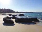
12 Just before the righthand bend, you ll find an intersection with the faint Grass Tree Track on the left, just after the heath becomes taller. (Remember this point if you are taking the optional side trip to Wybung Head). Follow the faint Grass Tree Track north over a small rise and through the dense vegetation. Soon the vegetation becomes shorter and the track becomes clearer. There are some distant ocean views as you meander gently downhill for a while before the track becomes steeper and eroded in places. Try to follow the main track, and avoid the smaller side tracks that have been created. As you approach the beach, you ll enter a forest of taller trees and finally reach Frazer Beach, just at the bottom end of Bongon Lagoon. This beach is a popular swimming area with a patrol service provided during Christmas, Easter and April school holidays. Tend left along the sand, keeping the lagoon to the left, then tend right up to the lower car park, past the picnic shelters and tables, to the end of Frazer Beach Road. The picnic area has wide ocean views over the beach and there s a nearby amenities block (toilet and showers) plus an emergency telephone.


13 Walk from the car park at the Bush Street Reserve across the park for 90 metres to the information board and track head at the back corner of the park. Walk through the timber barricade past the Headland Nature Trail sign. After spending a while winding through the bush your track will intersect with another, close to a fenced lookout platform. Veer left at the intersection and walk 15 metres to the Headland lookout platform. From the lookout, walk back to the previous intersection and turn left, following the Nature Trail arrow left through the bush. After passing over a small timber bridge you will reach the lighthouse car park. Head through the car park and to the left, then cross Bush Street to the Merchant Mariners memorial and lookout. There are some plaques in the footpath and in rocks at the memorial with information about merchant ships and lives lost during World War II. Take the footpath towards the lighthouse past an information board. After 120 metres you will


14 of the beach. Head up the steps and along the footpath with the metal handrail, around the headland and past the ocean pool to the bottom of the concrete steps, just below the toilet block. Walk up the steps away from the ocean pool, past the toilet block and along the footpath for 90 metres to an intersection signposted Cabbage Tree Harbour Rock Pool path, Bush St. Turn left soon you will reach an open grassy area. Turn right and find the information board and track head at the back of the park. You are now back at waypoint 2. Retrace your earlier steps across the park and back to the car park. arrive at the corner of the lighthouse cottage yard (the lighthouse can be booked for accommodation, T , with the grounds available for weddings and events, T ). From the corner of the yard, walk past the lighthouse cottages for 100 metres to the gate beside the lighthouse. Established in 1903 this was converted from kerosene to electric power in Tours are available on weekends every half hour from Head down the hill towards the ocean where, after 80 metres you ll find a viewing point at the top a set of steps offering views up and down the coastline. Walk down the timber steps to the beach at the bottom. At the beach turn left. There s the option to spend some time exploring the rock platform here, but make sure conditions are safe beforehand. Keeping the ocean to the right, walk around the headland until you reach the southern end of Lighthouse Beach. Still keeping the ocean to the right, head towards the rock platform at the north end
15


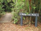
16 Walk from the car park through the timber fence and past an information board, following the sandy management trail. After 60 metres you will reach the intersection of the Red Gum Trail and the Burrawang Walking Track. Follow the Red Gum Trail arrow to the right and along the sandy track. You will climb a little through a series of bends, passing a couple more Red Gum Trail signs. Turn left when you arrive at the intersection with the Wetland Trail, dropping through a gully and up the other side. When you pass a Red Gum Forest information board, continue another 300 metres to find a wooden lookout platform with views to the north and northeast.


17 Continue along the sandy bush track through the forest and around to the left. You ll have glimpses of Tuggerah Lake to the right and the ocean to the left for a while, until you reach another fenced wooden lookout platform with more views west over Tuggerah Lake. Walk on through the forest for 400 metres to the intersection with the Lilly Pilly Loop Trail. Turn left, following the Lilly Pilly Loop Trail, down through a gully and some more forest before coming to an intersection with the Burrawang Walking Track. Again turn left, through the forest and some thick vegetation, passing a Burrawang Walking Track signpost. Eventually you will reach the signposted intersection with the Red Gum Trail (you are now back at waypoint 2). Veer right and follow the trail back to the car park.


18 TERRIGAL


19 Mill Creek Rd
20
21 11km (Mill Creek) Circuit, Trail, 141 Arboretum Loop Trail, Bellbird Trail, Birdie Beach, 13, 15 Bongon Lagoon, 14 Bouddi Coastal Walk, Bouddi National Park, Box Head, Brisbane Water National Park, , Brooklyn, 92, 93 Engravings, Bullimah Outlook, Bulls Hill Quarry, 100 Bundilla Lookout, 115 Bush Street Reserve, 17 Cabbage Tree Loop, Cabbage Tree Palm, 127 Casuarina Track, 37, 39 Charles Darcy Roberts, 71 Charles Kingsford Smith sculpture, 41, 47 Charles Sturt sculpture, 38, 39, 50 Clare s Bridge, 150 Croppy Point, 93 Devines Hill and Finch s Line Circuit, Dharug National Park, Donny s Track, 151 Dubbo Gully and 10-mile Hollow Circuit, Dubbo Gully to Upper Mangrove Cemetery, Emerald Pool Circuit, engravings, Aboriginal, , 111 Engravings, Bulgandry, Eve Williams Memorial Oval, 88 Fairview homestead, 146 Finch s Line, Flannel Flower Track, Frazer Beach, 12, 14 Geebung Track, 12 Gerrin Point Circuit, Girrakool Loop, Girrakool Picnic Area, 111, 115 Glenworth Valley, 134, 136 Gosford to Lisarow, Grass Tree Circuit, Grass Tree Track, 12, 14 Great North Walk, 88, 89, 116 Hawkesbury River, 92, 93 Headland Nature Trail, 17 Illoura Lookout, 115 Ironbark and Flannel Flower Circuit, Ironbark Road to Glenworth Valley, John Eyre sculpture, 51 John Eyre, 53 John Jack Higgs, 110 Kariong Brook, Katandra Reserve Explorer, Katandra Reserve, Killcare Heights (Marie Byles) Lookout, 73 Kincumber to Terrigal, Lillypilly Loop Trail, 24, Little Beach, Little Wobby to Woy Woy, Maitland Bay Information Centre, 69, 70, 74 Maitland Beach, 82 Marie Byles (Killcare Heights) Lookout, 73 Marie Byles, 73 Matthew Flinders sculpture, 41, 47 McPherson State Forest, Merchant Mariners Memorial, 17 Mill Creek picnic area, 156, 157, 158, 160, 161 Mount Wondabyne, 95, Mt Ettalong, Mt Olive, 135, 140, 141 Munmorah Coast Track, Norah Head Lighthouse Loop, Nurrunga Picnic Area, 41, 42, Old Great North Road, 144, 148, , Ouraka Point Loop, Patonga to Pearl Beach, Pearl Beach, 91 Pearl Caves, 90 Phil Houghton Suspension Bridge, 116 Piles Creek Circuit, Piles Creek, , Pindar Cave, Pindar Lookout, 105 Pindar Pool, 106 Pindar Waterfall, 106 Popran Creek from Peats Ridge Road, Popran National Park, Putty Beach & camping area, 76, 77, 83 Rainforest walk to Nurrunga, Red Ochre Beach, 13 Redgum Trail, Rocky Ponds, 92 Rumbalara Environmental Education Centre, 36, 49 Rumbalara Reserve, Rumbalara sculptures, 39 Seymour Pond, Simpson s Track, 150 Snapper Point, 15 Somersby Falls, Spring Beach, 94 SS Maitland, 80, 82, 83 St Johns Lookout & picnic area, 52, 59 Staples Lookout to Kariong Brook Falls, Staples Lookout to Mount Wondabyne Circuit, Strickland Falls and Cabbage Tree Loop, Strickland Forest, Ten Mile Hollow, Thomas James Bridge, 152, 155 Thommo s Loop, Timber Beach, 15 Tuggerah Lake, 22-24, Upper Mangrove Cemetary, 144, 145 Vera Murdoch, 110 Warrah Lookout, 88, 89 Wiseman s Ferry, 155 Woy Woy, 97 Wybung Head, 12, 15 Wyrrabalong Coast Walking Track, Wyrrabalong National Park, 22-24, Yaruga Picnic Area, 50
22
Girrakool to Wondabyne station
 Girrakool to Wondabyne station 4 hrs Hard track 9.5 km One way 4 438m This walk starts from the Girrakool picnic area and winds south, through the Brisbane Waters National Park. The walk crosses some long
Staples Lookout to Mt Wondabyne loop
 Staples Lookout to Mt Wondabyne loop 4 hrs 3 mins 1.8 km Circuit Hard track 337m This walk starts and finishes at Staples Lookout, on Woy Woy Rd. The walk follows sections of the Great North Walk around
Girrakool to Wondabyne station via Pindar caves
 Girrakool to Wondabyne station via Pindar caves 7 hrs 30 mins 18.1 km One way Experienced only 5 741m This walk starts from the Girrakool picnic area and winds south, following Piles creek into the Brisbane
Patonga to Staples Lookout
 Patonga to Staples Lookout 6 hrs 3 mins 17 km One way Hard track 4 72m This great walk explores much of the main ridge ridge running through Brisbane Water National Park. The walk visits a number of great
Patonga to Wondabyne station via Mt Wondabyne
 Patonga to Wondabyne station via Mt Wondabyne 7 hrs 3 mins 19.5 km One way Hard track 4 861m This walk explores some grand views, pleasant cascades, varied bushland and remote areas of Brisbane Waters
Patonga to Wondabyne station via Pindar Caves overnight
 Patonga to Wondabyne station via Pindar Caves overnight 2 Days Experienced only 28.1 km One way 5 1164m This overnight hike starts from Patonga beach and winds along a section of the Great North Walk,
Cowan to Wondabyne station via Patonga rest area
 Cowan to Wondabyne station via Patonga rest area 2 Days Hard track 33.4 km One way 4 1523m This section of the Great North Walk starts from Cowan train station and wanders past the majestic Jerusalem Bay
COLOUR G U I D E. Sydney to Newcastle: Australia s most accessible long-distance walk
 COLOUR G U I D E Sydney to Newcastle: Australia s most accessible long-distance walk Woodslane Press Pty Ltd Unit 7/5 Vuko Place Warriewood, NSW 2102 Australia Email: info@woodslane.com.au Tel: (02)
Western Commission Track to Dubbo Gully
 This two day walk follows a series of historic roads along clear and wide management trails. This walk explores the great views from Western Commission Track, the sandstone handicraft on the Old Great
Wondabyne station to Somersby Store
 Wondabyne station to Somersby Store 10 hrs Hard track 26.2 km One way 4 1164m This walk, following a section of the Great North Walk, starts from the Wondabyne train station and winds north, into the Brisbane
Mt Kuring-gai Track to Berowra station
 Mt Kuring-gai Track to Berowra station 4 hrs 15 mins 9.7 km One way Hard track 4 553m This walk explores three valleys, with great displays of wild flowers in spring, and some nice sandstone overhangs.
Leura Cascades to Gordon Falls Reserve
 Leura Cascades to Gordon Falls Reserve 1 hr 15 mins 1.8 km One way Moderate track 200m From Leura Park to Gordon Falls Park, this diverse walk offers fantastic views of the Jamison Valley, as well as two
Berowra to Cowan via Berowra Waters
 Berowra to Cowan via Berowra Waters 6 hrs Hard track 12.9 km One way 4 884m With train station at each end this walk explores the ridges and valleys around Berowra Waters. There are plenty of excellent
Erskine Creek via Pisgah Rock and Jack Evans
 Erskine Creek via Pisgah Rock and Jack Evans 4 hrs 30 mins 7.1 km Circuit Very experienced only 6 421m This walk visits some great lookouts and explores the lower section of Erskine Creek. Most of the
Somersby to Yarramalong via Stringy Bark Point
 Somersby to Yarramalong via Stringy Bark Point 2 Days Hard track 26.7 km One way 4 1201m This section of the Great North Walk starts form the Somersby General Store and follows the Great North Walk north
Crosslands to Cowan. 220m
 Crosslands to Cowan 7 hrs 30 mins 14 km One way Hard track 4 1103m This section of the Great North Walk starts from the Crosslands camping area and winds north alongside Berowra creek, passing through
Nature Track. 900m. 789m. 2 hrs 3.1 km Circuit. Hard track 238m. Blue Mountains National Park
 Nature Track 2 hrs 3.1 km Circuit Hard track 238m Largely following the ridges around the top edge of Wentworth Falls, this track is incredibly beautiful. After taking in the great views at Edinburgh Castle
Jerusalem Bay Track (Cowan to Brooklyn)
") Jerusalem Bay Track (Cowan to Brooklyn) 5 hrs 30 mins 13.4 km One way Hard track 4 654m This Cowan to Brooklyn Station walk is a popular section of the Great North Walk, with scenery ranging from foreshore
Jerusalem Bay Track (Cowan to Brooklyn) 5 hrs 30 mins 13.4 km One way Hard track 4 654m This Cowan to Brooklyn Station walk is a popular section of the Great North Walk, with scenery ranging from foreshore
Crosslands to Berowra Waters return
 Crosslands to Berowra Waters return 6 hrs Hard track 13.7 km Return 4 1005m This return walk starts from the Crosslands Reserve and follows the Great North Walk along Berowra creek. The walk includes some
Dadder Cave and Jack Evans track
 Dadder Cave and Jack Evans track 2 Days 10.3 km Circuit Very experienced only 535m This fairly short overnight walk is a great way to explore Erskine Creek. The walking along Erskine creek is mostly off
Gibberagong Track. 169m
 Gibberagong Track 2 hrs 30 mins 6.5 km One way Hard track 4 180m Starting in suburban Wahroonga, this wellmaintained track follows Cockle Creek down to Bobbin Head in the Ku-ring-gai Chase National Park.
Berowra Waters to Cowan Station
 Berowra Waters to Cowan Station 3 hrs 30 mins 7.2 km One way Hard track 597m This is a hilly walk out of the beautiful Berowra Waters valley to Cowan Station. There are many wide views across Berowra Creek
Crosslands to Brooklyn
 Crosslands to Brooklyn 2 Days Hard track 27.4 km One way 4 1757m From the Crosslands Reserve, this walk heads along the Great North Walk via Berowra Waters, Cowan, Jerusalem Bay and onto Brooklyn. This
Berowra to Hornsby. 9 hrs 18 mins 22.6 km One way. Hard track. 1423m
 Berowra to Hornsby 9 hrs 18 mins 22.6 km One way Hard track 4 1423m One of the longer day walks in Berowra Valley National Park, this walk mostly follows Berowra Creek along the Great North Walk. Excellent
Victoria Falls and Grose Valley to Blackheath Station
 This walk explores a fantastic section of the Grose Valley. Starting above Victoria Falls, the walk explores the cascades before dropping into the valley for the first nights rest at Burra Korain campsite.
Congewai Track Head (East) to Watagan Headquarters
 to Watagan Headquarters") Congewai Track Head (East) to Watagan Headquarters 7 hrs Hard track 17.2 km One way 4 973m This full day walk starts from the Congewai valley trackhead (east) and follows the Great North Walk up into the
Congewai Track Head (East) to Watagan Headquarters 7 hrs Hard track 17.2 km One way 4 973m This full day walk starts from the Congewai valley trackhead (east) and follows the Great North Walk up into the
Victoria Falls Lookout to Blue Gum Forest
 Victoria Falls Lookout to Blue Gum Forest 8 hrs Experienced only 13.8 km One way 5 112m This long day-walk follows a remote track down from Victoria Falls lookout, passing the waterfall, and into the Grose
Merritts Traverse. 1928m
 Merritts Traverse 3 hrs Hard track 5.8 km Circuit 4 167m This walk starts with a scenic journey to the top of the hill on the chairlift. Starting along Merritts Nature walk, this walk soon detours down
Somersby to the Basin Campsite
 Somersby to the Basin Campsite 3 Days Hard track 47.4 km One way 4 2032m This three day walk starts at the Somersby General Store and follows the Great North Walk, heading north, into the the Jilliby State
Hornsby station to Crosslands
 Hornsby station to Crosslands 6 hrs 45 mins 16.1 km One way Hard track 4 938m This section of the Great North Walk starts from Hornsby train station and winds down along the Blue Gum Walk into Fishponds.
Abbotts Falls Walking Track
 Abbotts Falls Walking Track 3 hrs 7.3 km Circuit Hard track 329m This circuit takes you through both dry and moist forest, using a combination of walking trails and wider tracks. The side trip to the dammed
The Prince Henry Cliff Walk
 The Prince Henry Cliff Walk 3 hrs 30 mins 6.8 km One way Moderate track 3 575m Going from Katoomba to Leura, this walk covers the top of the cliff line and most of the major lookouts. With brilliant vistas
National Pass. 893m. 665m. 3 hrs 30 mins 4.6 km Circuit. Hard track 773m. Blue Mountains National Park
 National Pass 3 hrs 3 mins 4.6 km Circuit Hard track 773m 4 This walk offers fantastic views of the Jamison Valley and the surrounding cliffs. Take time to explore the historic and very scenic ledge halfway
Guthega to Mt Twynam. 2183m. 1583m. 6 hrs 45 mins 14.8 km Return. Experienced only. 913m
 Guthega to Mt Twynam 6 hrs 45 mins 14.8 km Return Experienced only 5 913m This walk starts from Guthega and makes its way along the Snowy River to the Illawong Lodge, via the Blue Cow Creek flying fox.
Main Range Walk - Charlotte Pass to Mount Kosciuszko
 Main Range Walk - Charlotte Pass to Mount Kosciuszko 9 hrs Hard track 21.9 km Circuit 4 920m This full day walk explores some of the greatest alpine country on offer in NSW. The walk grants views of Blue,
Leura to Katoomba via Dardanelles Pass
 Leura to Katoomba via Dardanelles Pass 4 hrs 6.6 km One way Hard track 697m With approximately equal parts cliff-walk and forest track, this track truly shows what the cliff edges of the Jamison Valley
Victoria Falls and Grose Valley to Blackheath Station
 Victoria Falls and Grose Valley to Blackheath Station 3 Days Experienced only 22.5 km One way 5 158m This walk explores a fantastic section of the Grose Valley. Starting above Victoria Falls, the walk
Blackheath to Blue Gum loop
 Blackheath to Blue Gum loop 2 Days Hard track 24.1 km Circuit 4 1335m This walk is great for fit people getting into overnight walking, with its fantastic scenery and nostalgia as a classic overnighter.
Wentworth Pass. 893m. 535m. 4 hrs. Hard track 5.1 km Circuit. 692m
 Wentworth Pass 4 hrs Hard track 5.1 km Circuit 4 692m This walk offers a great way to explore the magical, upper section of the Valley of the Waters. The walk starts and finishes at Conservation Hut, which
Scenic Railway to Ruined Castle
 Scenic Railway to Ruined Castle 7 hrs 30 mins 12.4 km Return Hard track 4 963m This is a very popular, full day walk, in the Katoomba Area, offering great views of the valley. The walk follows the edge
Guthega to Thredbo camping overnight at Wilkensons Creek
 Guthega to Thredbo camping overnight at Wilkensons Creek 2 Days Experienced only 25.8 km One way 5 1364m This great overnight walk explores the Kosciusko National Park between Guthega and Thredbo, visiting
Main Range Track - Loop from Charlotte Pass camping near Mt Townsend
 Main Range Track - Loop from Charlotte Pass camping near Mt Townsend 2 Days Experienced only 27.7 km Circuit 5 1260m This great overnight walk starts from Charlotte Pass and provides access to some of
Thornleigh to Cowan. 2 Days. Hard track 35.9 km One way. 2337m
 Thornleigh to Cowan 2 Days Hard track 35.9 km One way 4 2337m Following the Great North Walk and Berowra Creek through Berowra Valley Regional Park, this walk cuts straight through the length of the Park.
Katoomba to Wentworth Falls via the Jamison Valley
 Katoomba to Wentworth Falls via the Jamison Valley 2 Days Experienced only 29.2 km One way 5 2135m This is the two day version of this popular and challenging walk. This walk passes popular sights including
Lady Carrington Drive
 Lady Carrington Drive 3 hrs 45 mins 9.7 km One way Moderate track 3 266m This walk follows the historic Lady Carrington Drive alongside the Hacking River. The old road is closed to traffic and provides
Victoria Falls to Blackheath Station
 Victoria Falls to Blackheath Station 2 Days Experienced only 22.2 km One way 5 1561m This is a fantastic overnight walk with a sleep in Acacia Flats camping area. The Grose Valley, with its views of the
Main Range Circuit from Guthega
 Main Range Circuit from Guthega 4 Days Experienced only 45 km Circuit 5 2317m This four day walk explores the Kosciuszko National Park, covering many of the key features of the park between Guthega and
Gordon to Hornsby (overnight at Scout camp)
") Gordon to Hornsby (overnight at Scout camp) 2 Days Hard track 25.8 km One way 4 125m This overnight walk starts from Gordon train station and winds through bush filled valleys to Hornsby station. From
Gordon to Hornsby (overnight at Scout camp) 2 Days Hard track 25.8 km One way 4 125m This overnight walk starts from Gordon train station and winds through bush filled valleys to Hornsby station. From
Out and about at Geehi
 Geehi Geehi Flats is a large area of flat floodplain on the banks of the Swampy Plains River. Located within Kosciuszko National Park, it is home to a popular campsite in summer for people wanting to enjoy
Self-Guided Walk Langdale Pikes. Start & Finish: NT car park (free to members) at Sticklebarn - on the right just beyond the New Dungeon Ghyll hotel.
 at Sticklebarn - on the right just beyond the New Dungeon Ghyll hotel.") Self-Guided Walk Langdale Pikes Key Information These mountains form a collection of spires and cliffs on the north side of Langdale. This walk visits four of the main tops Pavey Ark, Harrison Stickle,
Self-Guided Walk Langdale Pikes Key Information These mountains form a collection of spires and cliffs on the north side of Langdale. This walk visits four of the main tops Pavey Ark, Harrison Stickle,
Cormorant and Guillemot WEST PENTIRE CRANTOCK CORNWALL
 and WEST PENTIRE CRANTOCK CORNWALL Nearby Crantock Bay (view not from property) and West Pentire Crantock Cornwall TR8 5SE Fabulous coastal property with a two bedroom annexe overlooking Crantock Bay
Great Ocean Road Two Day Tour
 www.greatoceanroad.vc Great Ocean Road Two Day Tour This two day trip of approximately 530 kilometre starts from Melbourne and provides a good overview of features along the Great Ocean Road between Anglesea
beach. Make the ford and follow the trail out to the junction with Red Creek Tr in an open grassy area.
 Description: This is a moderate to slightly strenuous 22.8 mile backpack (add 2.6 miles if you do the packless out and back to the Lion s Head) that will have you exploring nearly every thing that is The
The Adams. Ultimate guide to business. Central Coast
 The Adams Ultimate guide to business Map of the Central Coast... 50 Demographics and other data... 51 Population... 51 Age profile... 52 Individual & Household income... 53 Educational attainments... 54
Leaden Boot Challenge ROUTE INSTRUCTIONS
 Leaden Boot Challenge ROUTE INSTRUCTIONS Section 1 Alstonefield to Ilam From the village hall car park turn R then L and pass through the village keeping to the R to enter Church Street. Pass the Church
Sponsored by. statestreet.com
 /STATESTREETISLANDWALK #ISLANDWALKJSY Sponsored by statestreet.com Important Information If you forget everything else PLEASE remember the following.» Remember to check OUT of every checkpoint» If you
Split Point Lighthouse Aires Inlet
 www.greatoceanroad.vc Great Ocean Road Three Day Tour 2 Night Stay This three day trip of approximately 730 kilometre starts from Melbourne and provides a good overview of features along the Great Ocean
HILL VIEW BUSHWALKERS Inc. PROGRAM. February - June 2018
 HILL VIEW BUSHWALKERS Inc. PROGRAM February - June 2018 Walkers usually meet to pool cars at Turramurra Memorial Park, Karuah Road Turramurra (the official starting point) unless public transport is specified
FOR SALE INDIAN OCEAN BEACHFRONT- HEADLAND PLOT
 June 2017 FOR SALE INDIAN OCEAN BEACHFRONT- HEADLAND PLOT Rasini, Kimbiji, Kizito Huonjwa, Temeke, Dar es Salaam, Tanzania A UNIQUE opportunity to acquire 9 hectares/22 acres of natural cliff and beachfront
Leaden Boot Challenge 2016 ROUTE INSTRUCTIONS
 Leaden Boot Challenge 2016 ROUTE INSTRUCTIONS Section 1 Alstonefield to Ilam (CP2) From the village hall car park turn R then L and pass through the village keeping to the R to enter Church Street. Pass
NEW TRACK: Purerua Peninsula - Taronui Reserve Access
 NEW TRACK: Purerua Peninsula - Taronui Reserve Access NQ01 Legal access way to Taronui Reserve from Purerua Road. At the side of Purerua Road (securing may be a problem). Department of Conservation and
Friends of Southern Eyre Peninsula Parks. Bushwalking in Lincoln National Park
 Friends of Southern Eyre Peninsula Parks Bushwalking in Lincoln National Park Select your trail Trail Time* Distance Trail Notes Stamford Hill to Surfleet Cove 1 hour one way 2.7 km one way An ideal coastal
Adventure Travel Trip Itinerary
 Adventure Travel Trip Itinerary Mt. Kilimanjaro & Mt. Meru Climbs, Tanzania July 8 23, 2017 Leader: Bill Blazek Date Activity (distances are approximate) Accommodation, Notes Meals 1 Saturday July 8, 2017
CWMGIEDD FROM ABERCRAVE
 Abercrave to Cwmgiedd Walk Page 1 Starting from The Abercrave Inn. Grid Ref: SN 824128 From the Abercrave Inn, an 11.3km (7 miles) walk to the foothills of the Cribarth Mountain, then through forest to
Illawarra Escarpment State Conservation Area Walking Tracks
 Illawarra Escarpment State Conservation Area Walking Tracks NPWS Illawarra Area Office Ground Floor, Government Office Block 84 Crown Street Wollongong NSW 2500 02 4223 3000 (Mon-Fri) Royal National Park
SOUTH BANK TO NEW FARM PARK
 MAY TUESDAY 1 st 9am - SOUTH BANK TO NEW FARM PARK - Follow the path through South Bank Parklands and cross the Goodwill Bridge. Continue on the north bank of the river through the Botanic Gardens and
Walks in Sydney Stephen Lord
 Walks in Sydney Stephen Lord SYDNEY HARBOUR N.P.: MANLY TO THE SPIT The foreshore walking track from Manly to the Spit passes through sections of Sydney Harbour National Park and offers an opportunity
NOVEMBER WEDNESDAY 9 - TENERIFFE CIRCUIT
 NOVEMBER WEDNESDAY 1 st 9 am - TENERIFFE CIRCUIT This walk around the suburb of Teneriffe includes a track winding up through tall trees and vegetation to Teneriffe Park. Distance 7 km some uphill walking
Aeron & Arth walks 4 walks for all the family to enjoy
 Aeron & Arth walks walks for all the family to enjoy Please take note that the maps illustrating these walks are intended as a rough guide only. You should use the most recent version of the relevant Ordnance
APPENDIX 19-II. Ontario Trail Network Trailheads EAST-WEST TIE TRANSMISSION PROJECT AMENDED ENVIRONMENTAL ASSESSMENT REPORT
 EAST-WEST TIE TRANSMISSION PROJECT AMENDED ENVIRONMENTAL ASSESSMENT REPORT APPENDIX 19-II Ontario Network heads Report. 1536607/2000/2219 Ontario Network heads in the n-commercial Land and Resource Use
Trail Phasing Plan. Note: Trails in the Clear Creek Canyon area (Segments will be finalized in the future to minimize wildlife impacts
 Note: Trails in the Clear Creek Canyon area (Segments 2 5 and a future JCOS connection) will be finalized in the future to minimize wildlife impacts Trail Phasing Plan P Parking 3 Easy Trail Intermediate
Bewl Water & the High Weald
 1 Bewl Water & the High Weald Stonegate station - Stonegate - Wallcrouch - Newbarn - Cousley Wood - Wood's Green - Wadhurst station Length: 9 ½ miles (15.3km) Underfoot: Large portions of this path are
National Recreation Trail Update Form
 National Recreation Trail Update Form Introduction Thank you for taking the time to complete this form. Your assistance will help ensure that the National Recreation Trail (NRT) database is complete and
Central Coast Hunter Range Region Discovery Program
 Central Coast Hunter Range Region Discovery Program Sydney to Newcastle General Inquiries NPWS (02) 4320 4200 (Monday - Friday) Detailed Information Anne Whyte, Discovery Coordinator NPWS (02) 4320 4205
1. Waterfall Gully Mt Lofty. 5 Of the Best Hikes in Adelaide
 Adelaide is a beautiful city, and one of the most incredible things about Adelaide is the quality of bushwalking available on the suburban fringe. It is surrounded by the Mt Lofty Ranges, and much of the
Discover. Ashhurst Domain. Nature s Playground
 Discover Ashhurst Domain Nature s Playground Discover Step back into New Zealand, Aotearoa, of generations long gone. Discover lush natural surrounds echoing with rich birdsong in one of the Manawatu s
DAY 1: Circular Quay to Greenwich Wharf
 DAY 1: Circular Quay to Greenwich Wharf Total Distance: 14km Time: Approximately 5 hours Walk Notes in Six Sections Section Name Length Time 1:1 Circular Quay to Milsons Point Station 2.5km 50mins 1:2
White Rock - Spring Mtn Conservation Estate
 White Rock - Spring Mtn Conservation Estate School Road, White Rock TRAILS OF IPSWICH www.ipswich.qld.gov.au Destination overview Proximity Paperbark Flats Picnic Area 14km (20 mins drive) from City centre
Difficult Run Stream Valley Park
 Difficult Run Stream Valley Park The more intense mountain bikers have known about for Difficult Run for some time. Equestrians have known it longer. Eight miles of unpaved trail, the Rails to River Trail
West Wirral (Dee Estuary)
") View of Hilbre Island from West Kirby with walkers at low tide. West Wirral (Dee Estuary) West Kirby is the start of the 12 mile long Wirral Way, the backbone of Wirral Country Park, the old Hooton to
View of Hilbre Island from West Kirby with walkers at low tide. West Wirral (Dee Estuary) West Kirby is the start of the 12 mile long Wirral Way, the backbone of Wirral Country Park, the old Hooton to
National Recreation Trail Application for Designation
 National Recreation Trail Application for Designation Introduction Thank you for your interest in the National Recreation Trail (NRT) program. Completed NRT application packages must be submitted by December
BULIMBA, TENERIFFE CIRCUIT
 JUNE SATURDAY 2 nd 6.45 am - BULIMBA, TENERIFFE CIRCUIT Cross the river to Teneriffe and uphill through bushland with views from the top. Meet Bulimba Ferry, Oxford Street UBD Map 160 J 3 some uphill walking
HIKING IN THE CANADIAN ROCKIES
 HIKING IN THE CANADIAN ROCKIES Distance Time Elevation y MORAINE LAKE TRAILS THE ROCKPILE 0.8 km (0.5 mi) 20 min 30 m (98 ft) Located adjacent to the Lodge, the short interpretive trail up the Rock Pile
Best Hikes on Orcas Island
 Published on San Juan Islands Washington Visitors Bureau Orcas Island Lopez Island Friday Harbor San Juan Island (https://www.visitsanjuans.com) Best Hikes on Orcas Island The Emerald Isle offers big trees,
Self-Guided Walk Malham, Gordale and Malham Tarn
 Self-Guided Walk Malham, Gordale and Malham Tarn Combine all the major geological attractions of Malham in this walk and hopefully leave enough time to enjoy the cafes, pubs and shops of the village. Malham
FEBRUARY SATURDAY 2ND EARLY MORNING WALKS
 FEBRUARY SATURDAY 2 ND 6 am - BULIMBA - VARIATION CHOICE CIRCUIT - There is the choice of either a flat walk or a variation which includes some hills Meet Bulimba Memorial Park Cnr Oxford & Stuart Streets
LAID BACK LIVING, SANDY BEACH STYLE
 LAID BACK LIVING, SANDY BEACH STYLE Surrounded by native bushland and green open spaces, and close to one of the best beaches on the Coffs Coast, every day feels like a relaxing holiday when you live in
Karina Barry & Brian Barry
 Thank you for confirming your stay with us. We are delighted that you've decided to visit us and we are looking forward to introducing you to all that Pretty Beach House has to offer. As you'll soon discover,
TREK TO TABLE MOUNTAIN
 SOUTH AFRICA TREK CHALLENGING ABOUT THE CHALLENGE South Africa is a land of incredible contrast and beauty. It possesses a vast array of landscapes, from dense tropical bush to open desert. Our trek takes
Orienteering. The fundamental outdoors skill!
 The fundamental outdoors skill! Orienteering Nothing will make you feel more confident in the out of doors like knowing how to find your way in the woods. Orienteering Prepared by: Jeffrey Lybarger Assistant
Ardingly Lake, Ouse Valley, Borde Hill
 point your feet on a new path Ardingly Lake, Ouse Valley, Borde Hill Distance: 14 km=9 miles or 12½ km=8 miles Region: West Sussex Author: Hautboy Refreshments: Borde Hill Map: Explorer 135 (Ashdown Forest)
Tiger Mountain State Forest:
 98 60 hikes within 60 miles: SEATTLE 20 Tiger Mountain State Forest: West Tiger Mountain Three Loop i KEY AT-A-GLANCE INFORMATION Length: 5.1 miles round-trip Configuration: Loop Difficulty: Moderate difficult
Hiking Trail Descriptions
 Hiking Trail Descriptions For ye shall go out with joy. And be led forth with peace. The mountains and the hills shall break forth before you in singing. And all the trees of the fields shall clap their
6 DAYS MACHAME ROUTES ON KILIMANJARO
 6 DAYS MACHAME ROUTES ON KILIMANJARO Day 1: Moshi Machame camp In the morning, we depart from our base hotel at approximately 8:00 AM for the Machame village where you begin the trek. From the park entrance
The Bridestone Rocks from Lydgate
 Print this page Back to results The Bridestone Rocks from Lydgate Ancient tracks and gritstone outcrops, with terrific views of the steepsided Cliviger Valley. Distance 5 miles (8km) Minimum time 2hrs
THE ADVENTURE AWAITS YOU...
 6 Day Garden Route Add on to Namaqualand Daisy Tour Day 1 Transfer to Upington Airport for the 08h50 flight to Cape Town. You will land in Cape Town at 10h10. Collect your rental car at Cape Town International
middle left: Riversleigh fossils lower left: Constance Range images: Hj Preuss... Thx
 Upstreampaddle Summer 2008 18 middle left: Riversleigh fossils lower left: Constance Range images: Hj Preuss... Thx top right: road west of the Isa middle right: Constance Range lower right: rocky outcrop
The Mendip Way. Route Directions and Maps Uphill to Wells
 The Mendip Way Route Directions and Maps Uphill to Wells Website: www.mendiphillsaonb.org.uk Email: mendip@mendiphillsaonb.org.uk Facebook & Twitter: @MendipHillsAONB Phone: 01761462338 1 Uphill to Loxton
King George Area: May 5-18, 2019
 King George Area: May 5-18, 2019 Section 1: Faraway Bay airstrip to Twin Falls: May 5-12 We fly to the Faraway Bay airstrip where we leave the food for the second section, don our packs and head toward
THURSDAY 9 - THORNTON STREET CIRCUIT
 FEBRUARY THURSDAY 1 st 9 am - THORNTON STREET CIRCUIT Walk beside the Kangaroo Point Cliffs and continue through South Bank returning along the top of the cliffs. Meet Thornton Street Ferry Terminal UBD