Leura to Katoomba via Dardanelles Pass
|
|
|
- Beatrice Webb
- 5 years ago
- Views:
Transcription


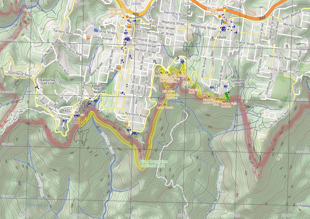
1 Leura to Katoomba via Dardanelles Pass 4 hrs 6.6 km One way Hard track 697m With approximately equal parts cliff-walk and forest track, this track truly shows what the cliff edges of the Jamison Valley have to offer, especially at Tarpeian and Fossil Rocks. There is a beautiful descent into the valley, as well as the mystique of Leura Forest, and a number of great spots to take a break along the way. The walk finishes with an exciting ride to the top of Scenic World on the world's steepest railway m 679m Maps, text & images are copyright wildwalks.com Thanks to OSM, NASA and others for data used to generate some map layers. Blue Mountains National Park

2 Gordon Falls Lookout Gordon Falls Lookout is a fenced lookout near the end of Lone Pine Rd, Leura. As the name suggests, there is a good view of Gordon Falls to the left. There is also a wonderful view along the escarpment to Sublime Point. The lookout is right at the edge of the cliff and also has a great view across the Jamison Valley, out to Mount Solitary. Narrow Neck and the 'back' of the Three Sisters are visible on the right-hand side. Elysian Rock Elysian Rock is a fenced, small, narrow lookout on a rock buttress. The floor is mostly uneven, natural sandstone and there is a bench seat with no shade. The lookout is right at the edge of the cliff and gives a great view straight across the Jamison Valley and out to Mount Solitary. Narrow Neck and the 'back' of the Three Sisters are visible on the right-hand side, and Sublime Point on the left. The lookout is along the Prince Henry Cliff Walk, just west of a concrete bridge spanning a chasm and near the end of Elysian Place, Leura. Olympian Lookout Olympian Lookout is a fenced lookout, just off the Prince Henry Cliff Walk, near Olympian Pde in Leura. The lookout is on a sloped, natural sandstone surface and has some steps cut to help improve access. The lookout is right at the edge of the cliff and provides a great view across the Jamison Valley, out to Mount Solitary. The 'back' of the Three Sisters, and also Narrow Neck, are both visible on the right, and Sublime Point on the left. Tarpeian Rock Tarpeian Rock is a great lookout, suspended high on a sandstone buttress, with circular patterns under foot. The view from the lookout extends from Kings Tableland on the left, to the 'back' of the Three Sisters and into Jamison Valley on the right. There are also great views across to Mount Solitary, Narrow Neck Plateau and the Ruined Castle. The name is derived from the Roman 'Tarpeian Rock', a steep cliff rocky point overlooking the Roman forum that was used as a place to execute people. Thankfully, this Tarpeian Rock has a much more peaceful feel about it. More info. The Rock The Rock is a small, partially-fenced lookout, about 10 metres from the Prince Henry Cliff Walk near Bridal Veil Falls. The old timber fence only partially covers the cliff line and the walk to the lookout can be slippery. The view from the lookout includes close-up views of the crowns of several trees. There is no view of Bridal Veil Falls, but the view does extend across to the cliffs at Bridal View Lookout. Before You walk Bushwalking is fun and a wonderful way to enjoy our natural places. Sometimes things go bad, with a bit of planning you can increase your chance of having an ejoyable and safer walk. Before setting off on your walk check 1) Weather Forecast (BOM Central Tablelands District) 2) Fire Dangers (Greater Sydney Region) 3) Park Alerts (Blue Mountains National Park) 4) Research the walk to check your party has the skills, fitness and equipment required 5) Agree to stay as a group and not leave anyone to walk solo Think before you TREK The 'Think before you TREK' program developed by NSW Police & NPWS promotes the benefits of planning ahead for your bushwalking trip by using an easy to remember acronym: T R E K Take adequate supplies of food, water, navigation and first aid equipment. Register your planned route and tell friends and family when you expect to return. Emergency beacon (PLB's) should be carried on walks with significant gaps in mobile coverage (check terrain profile). Keep to your planned route and follow the map and walking trails. Topo Maps The maps provided on wildwalks are helpful, but there are times where you may need maps covering a broader area. Maps that cover this walk include; 1: Map Series:Six Foot Track 1: Map Series:89301S KATOOMBA 1: Map Series:8930 KATOOMBA Grade This walk has been graded using the AS The overall grade of the walk is dertermined by the highest classification along the whole track. 4 Length Time Quality of track Grade 4/6 Hard track 6.6 km One way 4 hrs Rough track, where fallen trees and other obstacles are likely (4/6) Signs Directional signs along the way (3/6) Experience Required Weather Infrastructure Some bushwalking experience recommended (3/6) Storms may impact on navigation and safety (3/6) Limited facilities, not all cliffs are fenced (3/6)
3 Are you ready to have fun? Please ensure you and your group are well prepared and equipped for all possible hazards and delays. Check park closures, weather information and Fire Danger Rating before setting out. Optional side trips and alternate routes noted are not included in this walks overall grade, length or time estimate. Please allow extra time for resting and exploring areas of interest. The authors, staff and owners of wildwalks take care in preparing this information but will not accept responsibility for any inconvenience, loss or injury you may experience. Please take care, have fun - Happy Walking. Getting there You can get to Corner of Olympian Parade and Lone Pine Ave (gps: , ) by car or bus. Car: There is free parking available. You can get back from Scenic World (gps: , ) by car or bus. Car: There is free parking available. Find up to date and more information inlcuding; travel directions, weather, park closures and walker feedback at 0 Corner of Olympian Parade and Lone Pine Ave (40 m ) From the corner of Olympian Pde and Lone Pine Ave, this walk heads south through the park and, at the information sign, connects to a small bush track. Heading down just a few steps, the track comes to an intersection with a bush track Optional sidetrip to Gordon Falls Lookout (90 m 3 mins) Continue straight: From the intersection, this walk follows the hardened dirt path winding down towards the cliffs, dropping down a few sets of wooden steps and one steep metal staircase as it winds down through the bush to the cliffs edge at the Gordon Falls Lookout. At the end of this side trip, retrace your steps back to the main walk then Turn left Gordon Falls Lookout Gordon Falls Lookout is a fenced lookout near the end of Lone Pine Rd, Leura. As the name suggests, there is a good view of Gordon Falls to the left. There is also a wonderful view along the escarpment to Sublime Point. The lookout is right at the edge of the cliff and also has a great view across the Jamison Valley, out to Mount Solitary. Narrow Neck and the 'back' of the Three Sisters are visible on the right-hand side Int of Prince Henry Cliff Walk and Gordon Falls Lo (230 m ) Turn right: From the intersection, this walk follows the 'Prince Henry Cliff Walk' signpost along the bush track, winding down the hill to the bottom where it continues through the dense bush for a while before passing the 'Blue Mountains National Park' sign and coming to the intersection of the Elysian Rock Lookout Elysian Rock Elysian Rock is a fenced, small, narrow lookout on a rock buttress. The floor is mostly uneven, natural sandstone and there is a bench seat with no shade. The lookout is right at the edge of the cliff and gives a great view straight across the Jamison Valley and out to Mount Solitary. Narrow Neck and the 'back' of the Three Sisters are visible on the right-hand side, and Sublime Point on the left. The lookout is along the Prince Henry Cliff Walk, just west of a concrete bridge spanning a chasm and near the end of Elysian Place, Leura Elysian Lookout (230 m 13 mins) Veer left: From the lookout, this walk heads down the concrete steps and across the Buttenshaw Bridge, passing another fenced lookout, then climbing up the other side and continuing along the bush track that winds around the edge of the valley until coming to the intersection at the Olympian Rock Lookout. 0.5 Olympian Lookout Olympian Lookout is a fenced lookout, just off the Prince Henry Cliff Walk, near Olympian Pde in Leura. The lookout is on a sloped, natural sandstone surface and has some steps cut to help improve access. The lookout is right at the edge of the cliff and provides a great view across the Jamison Valley, out to Mount Solitary. The 'back' of the Three Sisters, and also Narrow Neck, are both visible on the right, and Sublime Point on the left. 0.5 Olympian Lookout (520 m 15 mins) Continue straight: From the lookout, the walk heads down the rock steps, keeping the valley down to the left. The walk continues down the long set of wooden steps. At the bottom of the stairs, the walk follows the track, which winds along the side of the hill. The track follows the base of some rock overhangs, and continues through the forest before climbing up another set of wooden stairs to the signposted intersection with the 'Tarpeian Rock' track Optional sidetrip to Tarpeian Rock (50 m ) Turn left: From the intersection, the walk follows the 'Tarpeian Rock' sign along the bush track, heading through the dense scrub for a short distance before coming to the Tarpeian Rock lookout. At the end of this side trip, retrace your steps back to the main walk then Turn left Tarpeian Rock Tarpeian Rock is a great lookout, suspended high on a sandstone buttress, with circular patterns under foot. The view from the lookout extends from Kings Tableland on the left, to the 'back' of the Three Sisters and into Jamison Valley on the right. There are also great views across to Mount Solitary, Narrow Neck Plateau and the Ruined Castle. The name is derived from the Roman 'Tarpeian Rock', a steep cliff rocky point overlooking the Roman forum that was used as a place to execute people. Thankfully, this Tarpeian Rock has a much more peaceful feel about it. More info Int of Prince Henry Cliff Walk and Tarpeian Rock T (220 m ) Continue straight: From the intersection, this walk follows the 'Leura Cascades' signpost down the rocky hill and through the dense forest until coming to the signposted intersection with the Bridal Veil lookout track. Turn right: From the intersection, the track follows the Leura Cascades sign down the long rocky hill until it flattens out and continues under a large rock overhang to 'The Rock' lookout The Rock The Rock is a small, partially-fenced lookout, about 10 metres from the Prince Henry Cliff Walk near Bridal Veil Falls. The old timber fence only partially covers the cliff line and the walk to the lookout can be slippery. The view from the lookout includes close-up views of the crowns of several trees. There is no view of Bridal Veil Falls, but the view does extend across to the cliffs at Bridal View Lookout The Rock (530 m 1) Turn right: From the lookout, this walk follows the bush track, winding around the side of the valley down to the left for a short while before coming to the intersection of the short bush track heading up to Cliff Drive. Veer left: From the intersection, the walk follows the bush track winding around the side of the hill, keeping the valley down to the left as it winds along to the intersection of the Cliff Drive track. Continue straight: Keeping the valley down the hill to the left, this walk follows the bush track heading around the side of the hill, steadily winding down the gentle slope to the top of a short set of wooden steps. The walk then follows the stairs down to the signposted intersection with the 'Leura Cascades' track, just before the footbridge. Turn sharp left: From the intersection, this walk follows the 'Leura Cascades' sign down the steps, keeping the handrail and creek to the right. After a short while, the walk heads along a timber platform and down some stairs to a rock platform, with great views of some cascades. From these cascades, the walk heads down more stairs, coming to an intersection just before two bridges, with great views of Leura Cascades Leura Cascades Leura Cascades is a lovely set of waterfalls with some bridges just below, allowing walkers to get up close to the creek. The area has a nice feel about it and is quite cool in summer. Much of the track near the cascades has handrails and the bridges are fenced. Allow some time to enjoy life among the cascades and fern trees in this valley. One bridge leads to a sandstone cave next to the pool and falls, a great place to enjoy the small section of canyon Leura Cascades (110 m 5 mins) Continue straight: From the bottom of Leura Cascades, this walk crosses the bridge (furthest from the falls), heads down the steps and comes to a fenced (unsignposted) lookout at the top of Bridal Veil Falls. From the lookout, the walk heads up the steep steps. The steps wind up the hill passing a cave with an old bench seat, then up the metal stairs to the fenced (unsignposted) round walk lookout with views down on Bridal Veil Falls. Continue straight: From the lookout, the walk heads up the metal staircases then along the fenced cliff ledge, with more great valley views. Soon the track heads down a few steps to come to a a four-way intersection, with a sign pointing back to 'Leura Cascades' (and the short left-hand track leading to a fenced (unnamed) lookout Int of Leura Cascades Round Walk and Fern Bower Tr (300 m ) Continue straight: From the intersection, this walk follows the 'Round Walk - Echo Point' sign along the track up the hill (with rock wall initially on the right). The track winds up the hill using the steps and, after passing a large gum, the track become less steep. Soon the track leads to an intersection with the signposted 'Prince Henry Cliff Walk'. Veer left: From the intersection, this walk follows the 'Echo Point' sign along the 'Prince Henrey Walk', winding around the side of the hill, passing two picnic seats under a rock overhang and continuing up the side of the hill. The walk climbs up the steep slope via metal and wooden steps, until it flattens out at a fenced boardwalk, which it crosses, continuing up another metal staircase to a bush track, which it follows around the side of the hill to the signposted intersection of the Bridal Veil Lookout track Optional sidetrip to Bridal Veil Lookout (40 m ) Continue straight: From the intersection, the walk follows the 'Bridal Veil Lookout' sign along the bush track, heading down the gentle hill through the bush. The walk steps up onto a rock shelf, following it for a short distance before coming to the signposted 'Bridal Veil Lookout'. At the end of this side trip, retrace your steps back to the main walk then Turn left Bridal Veil Lookout Bridal Veil Lookout provides a great views over Leura Forest and the Jamison Valley. Mount Solitary stands proudly in the distance. In keeping with its name, there are views of Bridal Veil Falls to the east. There is a small bench seat, but no shade Int of Prince Henry Cliff Walk and Bridal Veil Loo (50 m ) Turn right: From the intersection, the walk follows the track, keeping the cliffs and the valley down to the left, soon coming to the
4 signposted 'Copelands Lookout'. Veer right: From the intersection, the walk follows the bush track heading up the hill, keeping the cliffs and the valley down the hill to the left as it winds up to the Fossil Rock Lookout Fossil Rock Fossil Rock is a fenced lookout along Prince Henry Cliff Walk, near Katoomba. The lookout is close to Cliff Drive and gives great views along the Jamison Valley and over Mount Solitary, and along the far end of Kings Tableland. The sandstone floor of the lookout is mostly natural and has a few steps cut in it. The rock provides some natural sculptures to enjoy Fossil Rock (80 m 2 mins) Turn right: From Fossil Rock Lookout, the walk heads towards the short set of wooden steps that it climbs up the hill to the intersection of Cliff Drive. Turn left: From the intersection, this walk follows Cliff Drive up the gentle hill, passing the picnic seat at the point and heading around the left-hand side of the restaurant to the signposted intersection of 'Prince Henry Cliff Walk'. 2.3 Solitary Kiosk and Restaurant Solitary Restaurant offers fine dining in a heritage-listed building overlooking the beautiful Jamison Valley, as well as housing a kiosk for a more casual lunch. The kiosk is open for lunch 7 days a week, from 10am to 4pm (opens 11am weekdays in winter). The kiosk provides a casual dinning experience, with breakfast foods from $10 and lunches around $15 per dish. The restaurant is open for lunch 7 days from pm, and dinner on Fridays and Saturdays from 6pm. Light lunches start from $14, and dinners from $55 for a mouth-watering 2 course meal. Contact details - 90 Cliff Drive, Leura Falls Ph: More info. 2.3 Int of Cliff Drive and Prince Henry Cliff Walk (230 m ) Veer left: From Cliff Drive, opposite the car park behind Solitary Restaurant, this walk follows the 'Prince Henry Cliff Walk to Federal Pass' sign, down the short set of wooden steps to the intersection with the Echo Tree Lookout track. Turn right: From the intersection, the walk heads along the bush track, away from the Echo Tree Lookout, winding along the well-defined bush track for a short while before coming to the signposted intersection of the track to Leura Forest. Turn left: From the intersection, this walk follows the 'Leura Forest' sign along the bush track, winding down the hill for a short while before dropping down a set of wooden steps, to the signposted intersection with the 'Jamieson Lookout' track. Continue straight: From the intersection, this walk follows the dirt path, heading down the long set of wooden and rocky steps. The walk winds down past a picnic chair under a cliff overhang, and continues down the steps into the valley and through the forest to the Fern Bower information sign Fern Bower Fern Bower is an especially pleasant part of the Blue Mountains National Park, protected from heat and providing a great environment for fern trees, bracken ferns and moss to thrive. Fern Bower is a signposted area along the Federal Pass walking track, just below Jamieson Lookout and next to Linda Creek. This is a nice place to stop, rest and enjoy the bird noises Fern Bower (340 m 14 mins) Continue straight: From the information sign, the walk follows the track down the steps, passing a 'Rich History' information sign before coming down to the signposted intersection with the Amphitheatre track, at the top of a metal staircase. Turn right: From the intersection, this walk follows the 'Federal Pass Leura Forest' sign down the long metal staircase, to cross the bridge over Linda Creek in front of Lila Falls Lila Falls Lila Falls is a thin waterfall on Linda Creek. The Federal Pass crosses the creek (on a bridge) in front of these falls, just below the intersection with the amphitheatre. The waterfall is not the most spectacular one in this valley, but it is a nice cool spot to catch your breath Lila Falls crossing (180 m 1) Continue straight: From the Lila Falls, this walk follows the track heading down the hill, winding down a wooden walkway keeping the creek to the left. The track hugs the rock wall and passes under a shallow overhang. The walk continues down a staircase, then turns back down into the gully where it come to the taller and slender Linda Falls. After passing Linda Falls the walk follows the wooden steps down through the gulley, crossing the creek again before heading down to the Marguerite Cascades Marguerite Cascades Marguerite Cascades are a series of small cascades finishing with a taller waterfall of a few metres height, dropping into a shallow sandy pool. The cascades are on Linda Creek and a small bridge crosses the creek at the base of the falls as part of the Federal Pass walking track. The cascades are a nice place to sit and listen to the water running and the local birds in this cool shady area Marguerite Cascades (320 m 1) Continue straight: From the 'Marguerite Cascades', this walk follows the timber steps downhill, winding steeply for a short while until coming to an intersection with a faint track, marked with a timber 'Federal Pass' sign, just beside a foot bridge. Veer right: From the intersection, this walk crosses Linda Creek just below a pleasant cascade using the foot bridge with a handrail. This walk then continues along the bush track that winds along the valley floor, to the signposted 'Leura Forest'. From here, the walk continues along the wide bush track, passing a few picnic tables, and winding through the forest to an open area with a large gazebo and an information sign at the intersection of the Federal Pass and the Dardenelles tracks Leura Forest Leura Forest is a great picnic area in the Jamison Valley at the junction of the Federal Pass and Dardenelles Tracks. This place was home to a popular tea house (also known as 'Lady Carrington Dining Hall') from the late 1800's. Today walkers can still enjoy the historic rotunda and the foundations of the original tea house. The picnic area provides a great rest spot under the shade of the lilli pilli and coachwood forest Leura Forest (Int of Federal Pass and Dardenelles (1.2 km 3) Turn right: From the pergola at Leura Forest, this walk follows the 'Dardenelles Track' sign (the sign is up the hill behind the pergola) which heads up the stairs towards the cliff face, before turning left behind Leura Forest. The walk then leaves the shade of the forest, along a track with many fallen logs, until coming to the base of the Giant Staircase (signposted). Continue straight: From the bottom of the Giant Staircase, the walk follows the 'Scenic Railway' sign, keeping the main cliff to the right. The track continues with some great views over the Valley, and at several points, there are small seats to enjoy these fine views. The track then comes to a wellsignposted intersection, with signs pointing along the 'Federal Pass Track' and 'Dardanelles Pass' Int of Federal Pass, Scenic Railway and Dardenelle (2.1 km 1 hr ) Turn right: From the intersection, the walk follows the 'Federal Pass' sign towards 'Scenic Railway', keeping the main cliffs on the right. Not long after the intersection, the track passes 'under the sisters' rock formation (signposted). From here, the track turns and continues along a relatively stretch and, at several points, passes some notable rock formations and caves embedded in the cliffs. There are occasional good views that are not shrouded by the trees. The walk continues until coming to the base of Katoomba Falls, crossing these using a metal bridge know as 'Cooks Crossing'. (Just across the bridge, there is a picnic table.) Continue straight: From the intersection, this walk heads south-west away from Katoomba Falls along the bush track, soon passing the signposted 'Turpentine Tree'. Shortly after this tree, the track comes to an intersection with another bush track and set of stairs (on the right, signposted as 'Furber Steps'). Continue straight: From the bottom of Furber Steps, this walk follows the 'To base of scenic railway' sign keeping the handrail on the left, and following the flat bush track. This track passes through a small gate over a metal bridge at the bottom of the Scenic Railway Scenic Railway (Bottom Platform) (300 m 26 mins) Turn left: From the bottom platform, this walk heads up to the cliff top using the Scenic Railway. Hang on tight! This 415m-long journey is the world's steepest railway. Use of the railway costs $10 for adults and $5 for children one-way. Last train normally at 4:45pm (opens at 9am). More info Scenic World Scenic World is one of the most renowned tourist attractions of Katoomba and the Blue Mountains. Located on the cliffs of the Jamison Valley, visitors can enjoy a ride on the Scenic Railway (the world's steepest incline railway) or the Scenic Cableway, into the Jamison Valley, and explore the Scenic Walkway from the base. Alternatively, the Scenic Skyway offers a bird's eye view over the valley, with a glass floor to enhance the experience. Scenic World also features a revolving restaurant, a cafe and a kiosk, in addition to the documentary theatre and souvenir shop. Rides can be purchased, starting from $16 for adults and $10 for children, and combination or family passes are available. More info.
5
6 Summary navigation sheet for the Leura to Katoomba via Dardanelles Pass km From Up/Dwn Length Initial directions (Use full tracknotes and maps for more detail) Start Corner of Olympian Parade and Lone Pine Ave , (GR Katoomba, ) m From the corner of Olympian Pde and Lone Pine Ave, this walk heads south through the park and, at the information sign, connects to a small bush track Int of Prince Henry Cliff Walk and Gordon Falls , (GR Katoomba, ) m 3 mins Optional sidetrip to Gordon Falls Lookout. Continue straight: From the intersection, this walk follows the hardened dirt path winding down towards the cliffs, dropping down a few sets of wooden steps and one steep metal staircase as it winds down through the Int of Prince Henry Cliff Walk and Gordon Falls , (GR Katoomba, ) m Turn right: From the intersection, this walk follows the 'Prince Henry Cliff Walk' signpost along the bush track, winding down the hill to the bottom where it continues through the dense bush for a while before pass Elysian Lookout , (GR Katoomba, ) m 13 mins Veer left: From the lookout, this walk heads down the concrete steps and across the Buttenshaw Bridge, passing another fenced lookout, then climbing up the other side and continuing along the bush track that winds a Olympian Lookout , (GR Katoomba, ) m 15 mins Continue straight: From the lookout, the walk heads down the rock steps, keeping the valley down to the left Int of Prince Henry Cliff Walk Tarpeian Rock Track , (GR Katoomba, ) m Optional sidetrip to Tarpeian Rock. Turn left: From the intersection, the walk follows the 'Tarpeian Rock' sign along the bush track, heading through the dense scrub for a short distance before coming to the Tarpeian Rock lookout Int of Prince Henry Cliff Walk and Tarpeian Rock Track , (GR Katoomba, ) m Continue straight: From the intersection, this walk follows the 'Leura Cascades' signpost down the rocky hill and through the dense forest until coming to the signposted intersection with the Bridal Veil lookout track The Rock , (GR Katoomba, ) m 1 Turn right: From the lookout, this walk follows the bush track, winding around the side of the valley down to the left for a short while before coming to the intersection of the short bush track heading up to Cliff Leura Cascades , (GR Katoomba, ) m 5 mins Continue straight: From the bottom of Leura Cascades, this walk crosses the bridge (furthest from the falls), heads down the steps and comes to a fenced (unsignposted) lookout at the top of Bridal Veil Falls Int of Leura Cascades Round Walk and Fern Bower Track , (GR Katoomba, ) m Continue straight: From the intersection, this walk follows the 'Round Walk - Echo Point' sign along the track up the hill (with rock wall initially on the right) Int of Prince Henry Cliff Walk and Bridal Veil , (GR Katoomba, ) m Optional sidetrip to Bridal Veil Lookout. Continue straight: From the intersection, the walk follows the 'Bridal Veil Lookout' sign along the bush track, heading down the gentle hill through the bush Int of Prince Henry Cliff Walk and Bridal Veil , (GR Katoomba, ) m Turn right: From the intersection, the walk follows the track, keeping the cliffs and the valley down to the left, soon coming to the signposted 'Copelands Lookout' Fossil Rock , (GR Katoomba, ) m 2 mins Turn right: From Fossil Rock Lookout, the walk heads towards the short set of wooden steps that it climbs up the hill to the intersection of Cliff Drive Int of Cliff Drive and Prince Henry Cliff Walk , (GR Katoomba, ) m Veer left: From Cliff Drive, opposite the car park behind Solitary Restaurant, this walk follows the 'Prince Henry Cliff Walk to Federal Pass' sign, down the short set of wooden steps to the intersection with the Ec Fern Bower , (GR Katoomba, ) m 14 mins Continue straight: From the information sign, the walk follows the track down the steps, passing a 'Rich History' information sign before coming down to the signposted intersection with the Amphitheatre track, at th...
7 Powered by TCPDF ( Summary navigation sheet for the Leura to Katoomba via Dardanelles Pass km From Up/Dwn Length Initial directions (Use full tracknotes and maps for more detail) 2.87 Lila Falls crossing , (GR Katoomba, ) m 1 Continue straight: From the Lila Falls, this walk follows the track heading down the hill, winding down a wooden walkway keeping the creek to the left Marguerite Cascades , (GR Katoomba, ) m 1 Continue straight: From the 'Marguerite Cascades', this walk follows the timber steps downhill, winding steeply for a short while until coming to an intersection with a faint track, marked with a timber 'Federal Pas Leura Forest (Int of Federal Pass and Dardenelles Tracks) , (GR Katoomba, ) km 3 Turn right: From the pergola at Leura Forest, this walk follows the 'Dardenelles Track' sign (the sign is up the hill behind the pergola) which heads up the stairs towards the cliff face, before turning left behind Int of Federal Pass, Scenic Railway and Dardenelles Tracks , (GR Katoomba, ) km 1 hr Turn right: From the intersection, the walk follows the 'Federal Pass' sign towards 'Scenic Railway', keeping the main cliffs on the right Scenic Railway (Bottom Platform) , (GR Katoomba, ) m 26 mins Turn left: From the bottom platform, this walk heads up to the cliff top using the Scenic Railway.
Leura Cascades to Gordon Falls Reserve
 Leura Cascades to Gordon Falls Reserve 1 hr 15 mins 1.8 km One way Moderate track 200m From Leura Park to Gordon Falls Park, this diverse walk offers fantastic views of the Jamison Valley, as well as two
Nature Track. 900m. 789m. 2 hrs 3.1 km Circuit. Hard track 238m. Blue Mountains National Park
 Nature Track 2 hrs 3.1 km Circuit Hard track 238m Largely following the ridges around the top edge of Wentworth Falls, this track is incredibly beautiful. After taking in the great views at Edinburgh Castle
The Prince Henry Cliff Walk
 The Prince Henry Cliff Walk 3 hrs 30 mins 6.8 km One way Moderate track 3 575m Going from Katoomba to Leura, this walk covers the top of the cliff line and most of the major lookouts. With brilliant vistas
Scenic Railway to Ruined Castle
 Scenic Railway to Ruined Castle 7 hrs 30 mins 12.4 km Return Hard track 4 963m This is a very popular, full day walk, in the Katoomba Area, offering great views of the valley. The walk follows the edge
Victoria Falls Lookout to Blue Gum Forest
 Victoria Falls Lookout to Blue Gum Forest 8 hrs Experienced only 13.8 km One way 5 112m This long day-walk follows a remote track down from Victoria Falls lookout, passing the waterfall, and into the Grose
National Pass. 893m. 665m. 3 hrs 30 mins 4.6 km Circuit. Hard track 773m. Blue Mountains National Park
 National Pass 3 hrs 3 mins 4.6 km Circuit Hard track 773m 4 This walk offers fantastic views of the Jamison Valley and the surrounding cliffs. Take time to explore the historic and very scenic ledge halfway
Wentworth Pass. 893m. 535m. 4 hrs. Hard track 5.1 km Circuit. 692m
 Wentworth Pass 4 hrs Hard track 5.1 km Circuit 4 692m This walk offers a great way to explore the magical, upper section of the Valley of the Waters. The walk starts and finishes at Conservation Hut, which
Erskine Creek via Pisgah Rock and Jack Evans
 Erskine Creek via Pisgah Rock and Jack Evans 4 hrs 30 mins 7.1 km Circuit Very experienced only 6 421m This walk visits some great lookouts and explores the lower section of Erskine Creek. Most of the
Staples Lookout to Mt Wondabyne loop
 Staples Lookout to Mt Wondabyne loop 4 hrs 3 mins 1.8 km Circuit Hard track 337m This walk starts and finishes at Staples Lookout, on Woy Woy Rd. The walk follows sections of the Great North Walk around
Mt Kuring-gai Track to Berowra station
 Mt Kuring-gai Track to Berowra station 4 hrs 15 mins 9.7 km One way Hard track 4 553m This walk explores three valleys, with great displays of wild flowers in spring, and some nice sandstone overhangs.
Merritts Traverse. 1928m
 Merritts Traverse 3 hrs Hard track 5.8 km Circuit 4 167m This walk starts with a scenic journey to the top of the hill on the chairlift. Starting along Merritts Nature walk, this walk soon detours down
Berowra Waters to Cowan Station
 Berowra Waters to Cowan Station 3 hrs 30 mins 7.2 km One way Hard track 597m This is a hilly walk out of the beautiful Berowra Waters valley to Cowan Station. There are many wide views across Berowra Creek
Congewai Track Head (East) to Watagan Headquarters
 to Watagan Headquarters") Congewai Track Head (East) to Watagan Headquarters 7 hrs Hard track 17.2 km One way 4 973m This full day walk starts from the Congewai valley trackhead (east) and follows the Great North Walk up into the
Congewai Track Head (East) to Watagan Headquarters 7 hrs Hard track 17.2 km One way 4 973m This full day walk starts from the Congewai valley trackhead (east) and follows the Great North Walk up into the
Girrakool to Wondabyne station
 Girrakool to Wondabyne station 4 hrs Hard track 9.5 km One way 4 438m This walk starts from the Girrakool picnic area and winds south, through the Brisbane Waters National Park. The walk crosses some long
Abbotts Falls Walking Track
 Abbotts Falls Walking Track 3 hrs 7.3 km Circuit Hard track 329m This circuit takes you through both dry and moist forest, using a combination of walking trails and wider tracks. The side trip to the dammed
Guthega to Mt Twynam. 2183m. 1583m. 6 hrs 45 mins 14.8 km Return. Experienced only. 913m
 Guthega to Mt Twynam 6 hrs 45 mins 14.8 km Return Experienced only 5 913m This walk starts from Guthega and makes its way along the Snowy River to the Illawong Lodge, via the Blue Cow Creek flying fox.
Dadder Cave and Jack Evans track
 Dadder Cave and Jack Evans track 2 Days 10.3 km Circuit Very experienced only 535m This fairly short overnight walk is a great way to explore Erskine Creek. The walking along Erskine creek is mostly off
Victoria Falls to Blackheath Station
 Victoria Falls to Blackheath Station 2 Days Experienced only 22.2 km One way 5 1561m This is a fantastic overnight walk with a sleep in Acacia Flats camping area. The Grose Valley, with its views of the
Girrakool to Wondabyne station via Pindar caves
 Girrakool to Wondabyne station via Pindar caves 7 hrs 30 mins 18.1 km One way Experienced only 5 741m This walk starts from the Girrakool picnic area and winds south, following Piles creek into the Brisbane
Victoria Falls and Grose Valley to Blackheath Station
 Victoria Falls and Grose Valley to Blackheath Station 3 Days Experienced only 22.5 km One way 5 158m This walk explores a fantastic section of the Grose Valley. Starting above Victoria Falls, the walk
Berowra to Cowan via Berowra Waters
 Berowra to Cowan via Berowra Waters 6 hrs Hard track 12.9 km One way 4 884m With train station at each end this walk explores the ridges and valleys around Berowra Waters. There are plenty of excellent
Crosslands to Berowra Waters return
 Crosslands to Berowra Waters return 6 hrs Hard track 13.7 km Return 4 1005m This return walk starts from the Crosslands Reserve and follows the Great North Walk along Berowra creek. The walk includes some
Blackheath to Blue Gum loop
 Blackheath to Blue Gum loop 2 Days Hard track 24.1 km Circuit 4 1335m This walk is great for fit people getting into overnight walking, with its fantastic scenery and nostalgia as a classic overnighter.
Katoomba to Wentworth Falls via the Jamison Valley
 Katoomba to Wentworth Falls via the Jamison Valley 2 Days Experienced only 29.2 km One way 5 2135m This is the two day version of this popular and challenging walk. This walk passes popular sights including
Jerusalem Bay Track (Cowan to Brooklyn)
") Jerusalem Bay Track (Cowan to Brooklyn) 5 hrs 30 mins 13.4 km One way Hard track 4 654m This Cowan to Brooklyn Station walk is a popular section of the Great North Walk, with scenery ranging from foreshore
Jerusalem Bay Track (Cowan to Brooklyn) 5 hrs 30 mins 13.4 km One way Hard track 4 654m This Cowan to Brooklyn Station walk is a popular section of the Great North Walk, with scenery ranging from foreshore
Gibberagong Track. 169m
 Gibberagong Track 2 hrs 30 mins 6.5 km One way Hard track 4 180m Starting in suburban Wahroonga, this wellmaintained track follows Cockle Creek down to Bobbin Head in the Ku-ring-gai Chase National Park.
Crosslands to Cowan. 220m
 Crosslands to Cowan 7 hrs 30 mins 14 km One way Hard track 4 1103m This section of the Great North Walk starts from the Crosslands camping area and winds north alongside Berowra creek, passing through
Lady Carrington Drive
 Lady Carrington Drive 3 hrs 45 mins 9.7 km One way Moderate track 3 266m This walk follows the historic Lady Carrington Drive alongside the Hacking River. The old road is closed to traffic and provides
Hornsby station to Crosslands
 Hornsby station to Crosslands 6 hrs 45 mins 16.1 km One way Hard track 4 938m This section of the Great North Walk starts from Hornsby train station and winds down along the Blue Gum Walk into Fishponds.
Patonga to Wondabyne station via Mt Wondabyne
 Patonga to Wondabyne station via Mt Wondabyne 7 hrs 3 mins 19.5 km One way Hard track 4 861m This walk explores some grand views, pleasant cascades, varied bushland and remote areas of Brisbane Waters
Patonga to Staples Lookout
 Patonga to Staples Lookout 6 hrs 3 mins 17 km One way Hard track 4 72m This great walk explores much of the main ridge ridge running through Brisbane Water National Park. The walk visits a number of great
Main Range Walk - Charlotte Pass to Mount Kosciuszko
 Main Range Walk - Charlotte Pass to Mount Kosciuszko 9 hrs Hard track 21.9 km Circuit 4 920m This full day walk explores some of the greatest alpine country on offer in NSW. The walk grants views of Blue,
Victoria Falls and Grose Valley to Blackheath Station
 This walk explores a fantastic section of the Grose Valley. Starting above Victoria Falls, the walk explores the cascades before dropping into the valley for the first nights rest at Burra Korain campsite.
Berowra to Hornsby. 9 hrs 18 mins 22.6 km One way. Hard track. 1423m
 Berowra to Hornsby 9 hrs 18 mins 22.6 km One way Hard track 4 1423m One of the longer day walks in Berowra Valley National Park, this walk mostly follows Berowra Creek along the Great North Walk. Excellent
Main Range Track - Loop from Charlotte Pass camping near Mt Townsend
 Main Range Track - Loop from Charlotte Pass camping near Mt Townsend 2 Days Experienced only 27.7 km Circuit 5 1260m This great overnight walk starts from Charlotte Pass and provides access to some of
Somersby to Yarramalong via Stringy Bark Point
 Somersby to Yarramalong via Stringy Bark Point 2 Days Hard track 26.7 km One way 4 1201m This section of the Great North Walk starts form the Somersby General Store and follows the Great North Walk north
Wondabyne station to Somersby Store
 Wondabyne station to Somersby Store 10 hrs Hard track 26.2 km One way 4 1164m This walk, following a section of the Great North Walk, starts from the Wondabyne train station and winds north, into the Brisbane
Patonga to Wondabyne station via Pindar Caves overnight
 Patonga to Wondabyne station via Pindar Caves overnight 2 Days Experienced only 28.1 km One way 5 1164m This overnight hike starts from Patonga beach and winds along a section of the Great North Walk,
Guthega to Thredbo camping overnight at Wilkensons Creek
 Guthega to Thredbo camping overnight at Wilkensons Creek 2 Days Experienced only 25.8 km One way 5 1364m This great overnight walk explores the Kosciusko National Park between Guthega and Thredbo, visiting
Crosslands to Brooklyn
 Crosslands to Brooklyn 2 Days Hard track 27.4 km One way 4 1757m From the Crosslands Reserve, this walk heads along the Great North Walk via Berowra Waters, Cowan, Jerusalem Bay and onto Brooklyn. This
Cowan to Wondabyne station via Patonga rest area
 Cowan to Wondabyne station via Patonga rest area 2 Days Hard track 33.4 km One way 4 1523m This section of the Great North Walk starts from Cowan train station and wanders past the majestic Jerusalem Bay
Somersby to the Basin Campsite
 Somersby to the Basin Campsite 3 Days Hard track 47.4 km One way 4 2032m This three day walk starts at the Somersby General Store and follows the Great North Walk, heading north, into the the Jilliby State
Main Range Circuit from Guthega
 Main Range Circuit from Guthega 4 Days Experienced only 45 km Circuit 5 2317m This four day walk explores the Kosciuszko National Park, covering many of the key features of the park between Guthega and
Thornleigh to Cowan. 2 Days. Hard track 35.9 km One way. 2337m
 Thornleigh to Cowan 2 Days Hard track 35.9 km One way 4 2337m Following the Great North Walk and Berowra Creek through Berowra Valley Regional Park, this walk cuts straight through the length of the Park.
Gordon to Hornsby (overnight at Scout camp)
") Gordon to Hornsby (overnight at Scout camp) 2 Days Hard track 25.8 km One way 4 125m This overnight walk starts from Gordon train station and winds through bush filled valleys to Hornsby station. From
Gordon to Hornsby (overnight at Scout camp) 2 Days Hard track 25.8 km One way 4 125m This overnight walk starts from Gordon train station and winds through bush filled valleys to Hornsby station. From
Western Commission Track to Dubbo Gully
 This two day walk follows a series of historic roads along clear and wide management trails. This walk explores the great views from Western Commission Track, the sandstone handicraft on the Old Great
DAY 1: Emu Plains to Glenbrook Wednesday, January 2, 2019
 DAY 1: Emu Plains to Glenbrook Wednesday, January 2, 2019 Some sun: 34 C / 21 C 3mm Meeting time: 8.00am @ Our Lady of the Way Catholic Church, Emu Plains [15 Troy Street, Emu Plains; altitude: 32m] Mass:
The Mendip Way. Route Directions and Maps Uphill to Wells
 The Mendip Way Route Directions and Maps Uphill to Wells Website: www.mendiphillsaonb.org.uk Email: mendip@mendiphillsaonb.org.uk Facebook & Twitter: @MendipHillsAONB Phone: 01761462338 1 Uphill to Loxton
Sponsored by. statestreet.com
 /STATESTREETISLANDWALK #ISLANDWALKJSY Sponsored by statestreet.com Important Information If you forget everything else PLEASE remember the following.» Remember to check OUT of every checkpoint» If you
Hindhead, Keffolds Copse and Gibbet Hill
 point your feet on a new path, Keffolds Copse and Gibbet Hill Distance: 6 km=4 miles Region: Surrey Author: Schwebefuss Refreshments: Punch Bowl Café moderate walking Date written: 14-apr-2015 Last update:
Walks in Sydney Stephen Lord
 Walks in Sydney Stephen Lord SYDNEY HARBOUR N.P.: MANLY TO THE SPIT The foreshore walking track from Manly to the Spit passes through sections of Sydney Harbour National Park and offers an opportunity
Little Grand Canyon near Pomona, Illinois
 Little Grand Canyon near Pomona, Illinois Below: View of the trail and the terrain created using the Map My Hike app Below: Summary of the hike created using the Map My Hike app Presented by: Jennifer
GOLDEN EARS PROVINCIAL PARK
 GOLDEN EARS PROVINCIAL PARK Trail Information as of October 10 th 2015 Do not underestimate the mountainous wilderness of Golden Ears Provincial Park. The combination of rugged terrain and rapidly changing
Beautiful Walks from the Blue Ball Inn
 Walk No. 5 RIVER VALLEYS AND MOOR Countisbury, Watersmeet, Hillsford Bridge, Cheriton, Shilstone Hill, Rockford and Chiselcombe. 8.5 MILES APPROX. Walking time four and a half hours approx. OS 1;25,000
Tiger Mountain State Forest:
 98 60 hikes within 60 miles: SEATTLE 20 Tiger Mountain State Forest: West Tiger Mountain Three Loop i KEY AT-A-GLANCE INFORMATION Length: 5.1 miles round-trip Configuration: Loop Difficulty: Moderate difficult
Illawarra Escarpment State Conservation Area Walking Tracks
 Illawarra Escarpment State Conservation Area Walking Tracks NPWS Illawarra Area Office Ground Floor, Government Office Block 84 Crown Street Wollongong NSW 2500 02 4223 3000 (Mon-Fri) Royal National Park
Aira Force & Ullswater Access Statement
 Aira Force & Ullswater Access Statement Aira Force, Watermillock, Penrith, CA11 0JS T: 017684 82067 E: ullswater@nationaltrust.org.uk Section 1: Aira Force Section 2: Ullswater Countryside Section 1: Aira
C E N T R A L C A T S K I L L S
 120 C E N T R A L C A T S K I L L S Central Catskills Once out of the southern parts of the Catskills, the Long Path enters the more well traveled and civilized regions. The trail joins the Devil s Path,
Ystwyth and Rheidol Bridleway Routes. Route 2:Llanilar Circular
 Ystwyth and Rheidol Bridleway Routes Route 2:Llanilar Circular Route overview and terrain: A long circle using connecting ridges with fine views to link the Rheidol and Ystwyth river valleys. The route
Marilla Reservoir to Chestnut Ridge via Marilla Trails and Bullis Hollow Trail east to west
 USGS topographic maps useful to this hike are the Bradford and Stickney 7.5 minute sectionals. These notes are designed to assist in identifying distance and location using geophysical and man-made characteristics
Leaden Boot Challenge ROUTE INSTRUCTIONS
 Leaden Boot Challenge ROUTE INSTRUCTIONS Section 1 Alstonefield to Ilam From the village hall car park turn R then L and pass through the village keeping to the R to enter Church Street. Pass the Church
Out and about at Geehi
 Geehi Geehi Flats is a large area of flat floodplain on the banks of the Swampy Plains River. Located within Kosciuszko National Park, it is home to a popular campsite in summer for people wanting to enjoy
COLOUR G U I D E. Sydney to Newcastle: Australia s most accessible long-distance walk
 COLOUR G U I D E Sydney to Newcastle: Australia s most accessible long-distance walk Woodslane Press Pty Ltd Unit 7/5 Vuko Place Warriewood, NSW 2102 Australia Email: info@woodslane.com.au Tel: (02)
Hadleigh Castle and Chalkwell Oaze
 1 Hadleigh Castle and Chalkwell Oaze Benfleet station Hadleigh Park Hadleigh Castle Leigh-on-Sea Chalkwell station A short stroll through the lush woods of Hadleigh Park high above the Thames-side marshes,
Kakadu Highlights No. 9: September 23 - October 6, 2018
 Kakadu Highlights No. 9: September 23 - October 6, 2018 Section 1: Barramundi Creek: September 23-26 We begin with a four to six hour, 350 kilometre drive from Darwin. The last 45 kilometres is on a 4WD
DAY 1: Circular Quay to Greenwich Wharf
 DAY 1: Circular Quay to Greenwich Wharf Total Distance: 14km Time: Approximately 5 hours Walk Notes in Six Sections Section Name Length Time 1:1 Circular Quay to Milsons Point Station 2.5km 50mins 1:2
ID: 283 Distance: 6.2 miles Height gain: 500 Metres Map: Explore OL 19 Contributor David and Chris Stewart
 Walkingworld Wild Boar Fell ID: 283 Distance: 6.2 miles Height gain: 500 Metres Map: Explore OL 19 Contributor David and Chris Stewart Features Birds, Great Views, Hills or Fells Description: Wild Boar
The Rocher du Long Boyau and the Gorges du Houx
 A walk proposed by Netra From the Ermitage de Franchard, this is a very varied hike which will take you past old sandstone quarries, the Gorges du Houx and the charming Mare aux Pigeons. On the route are
Leaden Boot Challenge 2016 ROUTE INSTRUCTIONS
 Leaden Boot Challenge 2016 ROUTE INSTRUCTIONS Section 1 Alstonefield to Ilam (CP2) From the village hall car park turn R then L and pass through the village keeping to the R to enter Church Street. Pass
Trail Phasing Plan. Note: Trails in the Clear Creek Canyon area (Segments will be finalized in the future to minimize wildlife impacts
 Note: Trails in the Clear Creek Canyon area (Segments 2 5 and a future JCOS connection) will be finalized in the future to minimize wildlife impacts Trail Phasing Plan P Parking 3 Easy Trail Intermediate
HARDMOORS 55 RACE ROUTE 2018 HELMSLEY - GUISBOROUGH
 HARDMOORS 55 RACE ROUTE 2018 HELMSLEY - GUISBOROUGH HELMSLEY - CHECKPOINT 1 (WHITE HORSE) 1. Leave RACE START, continue ahead on road (Baxtons Sprunt) At crossroads turn right down Canons Garth eventualy
San Miguel to Caserio de la Hoya Circular (San Miguel)
") Tenerife Sur: Short Walks Under 10 km San Miguel to Caserio de la Hoya Circular (San Miguel) Route Summary An informative and scenic walk back in time from San Miguel to below El Roque, overlooking the
Tenerife Sur: Short Walks Under 10 km San Miguel to Caserio de la Hoya Circular (San Miguel) Route Summary An informative and scenic walk back in time from San Miguel to below El Roque, overlooking the
CWMGIEDD FROM ABERCRAVE
 Abercrave to Cwmgiedd Walk Page 1 Starting from The Abercrave Inn. Grid Ref: SN 824128 From the Abercrave Inn, an 11.3km (7 miles) walk to the foothills of the Cribarth Mountain, then through forest to
beach. Make the ford and follow the trail out to the junction with Red Creek Tr in an open grassy area.
 Description: This is a moderate to slightly strenuous 22.8 mile backpack (add 2.6 miles if you do the packless out and back to the Lion s Head) that will have you exploring nearly every thing that is The
Baggy Point, Croyde, North Devon
 Baggy Point, Croyde, North Devon A walk using the South West Coast Path that is likely to be suitable for people with impaired mobility or with a pushchair, wheelchair, or mobility scooter. The Coast Path
Asheville & WNC Hikes
 Asheville & WNC Hikes Amazingly, we have 3,000+ miles of free public hiking trails near Asheville, including 1,600 miles in the Pisgah and Nantahala National Forests, 850 miles in Great Smokey Mountains
Hiking Las Vegas.com
 Hike: Mt. Wilson via First Creek Canyon route Trailhead: First Creek marked Distance: 10 miles up and back Elevation gain: 3,400 feet Elevation of Peak: 7,070 feet Time: 7 to 9 hours (up and back) Difficulty:
Printed in China by Designed by Coral Lee Main cover image: Broken Bay
 Woodslane Press Pty Ltd Unit 7/5 Vuko Place Warriewood, NSW 2102 Australia Email: info@woodslane.com.au Tel: (02) 9970 5111 Fax: (02) 9970 5002 http://travelandoutdoor.bookcentre.com.au First published
Matthiessen State Park Dells Area Hike
 90 Easy Hikes Close to Home At the south end of the hike, you ll climb on top of a mound left over from a former coal-mining operation in the park. Not far from Goose Lake Prairie, the town of Morris hosts
Arches of the. Sandflats Area. By Virginia Allen
 Arches of the Sandflats Area By Virginia Allen TABLE OF CONTENTS Introduction Dedication Road Log Arches 1. Perforated View Arch 2. Fee Booth Arch 3. Windsong Arch 4. Weird Arch 5. Resting Arch 6. Bike
Slad over to Pitchcombe and back
 The walk climbs up from Slad over Wickridge Hill, descends to near Pitchcombe, then climbs back over Wickridge hill and round the back of Slad. Page 1 Start Point: SO 8718 0732 The Woolpack, Slad Length:
Hiking Las Vegas.com
 Hike: Juniper Peak up and back Trailhead: Oak Creek Canyon marked Distance: 5.5 miles round trip Elevation gain: 2,200 feet Elevation peak: 6,109 feet Time: 4 to 5 hours - Up and back Difficulty: 3 Danger
This path goes past an old tree nursery and sawmill. After 800m it crosses over a lane. Follow the bridleway fingerpost into the woods.
 FRENSHAM PONDS 11K CIRCULAR TRAIL 2½ HRS GU10 2DA This magnificent heathland trail starts in woodland and then brings you out onto the open heather of Frensham Common, with no roadwork! The route runs
Self-Guided Walk Langdale Pikes. Start & Finish: NT car park (free to members) at Sticklebarn - on the right just beyond the New Dungeon Ghyll hotel.
 at Sticklebarn - on the right just beyond the New Dungeon Ghyll hotel.") Self-Guided Walk Langdale Pikes Key Information These mountains form a collection of spires and cliffs on the north side of Langdale. This walk visits four of the main tops Pavey Ark, Harrison Stickle,
Self-Guided Walk Langdale Pikes Key Information These mountains form a collection of spires and cliffs on the north side of Langdale. This walk visits four of the main tops Pavey Ark, Harrison Stickle,
1. Waterfall Gully Mt Lofty. 5 Of the Best Hikes in Adelaide
 Adelaide is a beautiful city, and one of the most incredible things about Adelaide is the quality of bushwalking available on the suburban fringe. It is surrounded by the Mt Lofty Ranges, and much of the
Non-motorized Trail Plan & Proposal. August 8, 2014
 Town of Star Valley Ranch, Wyoming and the Star Valley Ranch Association in partnership with the USDA Forest Service, Bridger-Teton National Forest, Greys River Ranger District Non-motorized Trail Plan
Fetcham Downs and Bocketts Farm A magical teashop walk
 point your feet on a new path Fetcham Downs and Bocketts Farm A magical teashop walk Distance: 3 km=2 miles or 4 km=2½ miles Region: Surrey Author: Fusszweig Refreshments: Bocketts Farm easy walking Date
Best of Australia. 14 days/13 nights ITINERARY
 Best of Australia Hop aboard this 14-day trip down Australia s East Coast and make the most of your time. Offering a solid mix of must-do experiences and uncommon adventures, you ll learn to surf at Byron
Hiking Trail Descriptions
 Hiking Trail Descriptions For ye shall go out with joy. And be led forth with peace. The mountains and the hills shall break forth before you in singing. And all the trees of the fields shall clap their
Walking Track Classification System Parks and Wildlife Service
 Appendix A Walking Track Classification Specifications Walking Track Classification System Parks and Wildlife Service This Walking Track Classification System is the outcome of a review of the track classifications
Beaver Creek State Park
 GENERAL INFORMATION Name of Park/Forest/Facility: Beaver Creek State Park County: Columbiana (St. Clair Township) Address: 12816 Sprucevale Road (ie County Rd 428) (street #, city) East Liverpool, Ohio
TREK THE ROCKIES ABOUT THE CHALLENGE TREK THE ROCKIES FOR HIGHLAND HOSPICE CANADA TREK DEMANDING
 TREK THE ROCKIES CANADA TREK DEMANDING ABOUT THE CHALLENGE The Canadian Rockies are justifiably world-famous for their magnificent scenery: the combination of impressive, jagged mountains, bright turquoise
GIFFORD PINCHOT NATIONAL FOREST
 GIFFORD PINCHOT NATIONAL FOREST 9341 Wright Meadow 93 Spencer Meadow Spencer Butte 4247' 30 30A 19 24 80 31C Lewis River Lower Falls 5 Quartz Creek 90 Taidnapam Falls Upper Falls 31 Spencer Peak 3861'
A Circular Walk from Chapel Carn Brea
 A Circular Walk from Chapel Carn Brea 4.3 Miles A Walk Visiting Five Historic Ancient Sites This circular walk offers the possibility of several alternatives, depending on the walker s available time and
Mt Wilson Mt Irvine Bushwalking Group
 Mt Wilson Mt Irvine Bushwalking Group Volume 26 Issue 6 & 7 June & July 2016 LEURA CASCADES TO LYREBIRD DELL OUR MAY WALK LEURA CASCADES, GORDON FALLS, POOL OF SILOAM and LYREBIRD DELL at LEURA Friday
Prince Regent National Park
 Prince Regent National Park 23 rd June- 14 th July 2019 Garimbu Creek, Moran and Roe River Area Notes written by Cassie Newnes This area has something for everyone, magnificent scenery, stunning waterfalls,
Lake Wissota Access Locations within the LaFayette Township. By Chad Martin
 Lake Wissota Access Locations within the LaFayette Township By Chad Martin Anson/ Wissota Access Point # 1 Road: 195 th St. Associated Fire Numbers: 13294 Defining Characteristics: Forested from road
Bewl Water & the High Weald
 1 Bewl Water & the High Weald Stonegate station - Stonegate - Wallcrouch - Newbarn - Cousley Wood - Wood's Green - Wadhurst station Length: 9 ½ miles (15.3km) Underfoot: Large portions of this path are
Great Ocean Road Two Day Tour
 www.greatoceanroad.vc Great Ocean Road Two Day Tour This two day trip of approximately 530 kilometre starts from Melbourne and provides a good overview of features along the Great Ocean Road between Anglesea
BANKSTOWN BUSHWALKING CLUB INC. WALKS AND SOCIAL PROGRAM: AUTUMN 2016
 BANKSTOWN BUSHWALKING CLUB INC. WALKS AND SOCIAL PROGRAM: AUTUMN 2016 PHONE: (02) 9773 9141 E-MAIL: bankstownbush@gmail.com WEB SITE: http://www.bankstownbushwalkingclub.org.au/ POSTAL ADDRESS: PO Box