Walks in Sydney Stephen Lord
|
|
|
- Hugh Conley
- 5 years ago
- Views:
Transcription


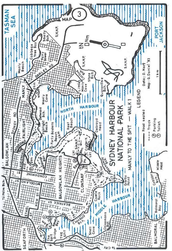
1 Walks in Sydney Stephen Lord SYDNEY HARBOUR N.P.: MANLY TO THE SPIT The foreshore walking track from Manly to the Spit passes through sections of Sydney Harbour National Park and offers an opportunity for a peaceful harbour-side walk. The grade is easy and the track is well defined with many markers - and there are many vantage points to enjoy the views of both main and middle harbours. From Manly Cove walk along the Esplanade and follow the path to King Ave and then to North Harbour Reserve, Fairlight. This is the starting point of Govenor Phillip's four-day inland walk in 1788 to French's Forest - Turramurra - Bungaroo - Middle Head, and is marked by a plaque at the top of the steps. Follow the pathway across the Reserve to Harbour Street. Turn sharp left at Clarence Street to cross a wooden bridge into Goulay Ave. Turn left through Wellings Reserve, an area with Hawkesbury sandstone vegetation, and on to Forty Baskets Beach - a good place to swim. Forty baskets of fish were caught here one day in 1885 for the Garrison on North Head. In 1860, a hermit lived here and flew a white flag each day to show he was still alive. Proceed along the rocks to the boundary of Sydney Harbour National Park. At a track junction, take the track ahead to Reef Beach, then continue on as the track climbs up away from the foreshore. After about 200m there is a track junction. The track south leads to Crater Cove where there are shanty dwellings which date from the 1920s. To continue on, keep on up the steep slope, and follow the sign to Arabanoo Lookout, off to the right of the main route. Follow the roadway SW, then pick up the clearly defined track to Grotto Point Lookout. Beyond the lookout the track drops down. Watch for the marker which shows the way to Grotto Point Lighthouse, due south 400m (20 minutes return). A First Fleet survey party camped at the site of Grotto Point Lighthouse on 28th January The lighthouse was built in 1911 to guide ships entering Sydney Harbour, when aligned with the Parrawi Head light at Mosman. Return to the track junction and head west down a series of steps. Sandstone formations include a wave-shaped rock and overhanging ledge above an eroded shale lens. Pass Castle Rock and continue following the shoreline pathway for a further 20 minutes to emerge on Clontarf Beach. Continue ahead and follow the beach as it swings around north past the enclosed pool and a shop in a grassy reserve. Next walk around Sandy Bay where there is a sign to guide you up steps and on to the track to Fisher Bay. Walk along a board-walk then through sub-tropical rainforest at the head of the bay. The next 200m follow the old tram route to Ellery's Punt Reserve, the site of the old punt landing. The punt started operation in A pedestrian underpass can take you to the western side of Spit Road, for the bus to Manly. Grade: Easy, 100m asc. Distance: 9km. Public Transport: Bus to Manly and from the Spit. SYDNEY HARBOUR N.P.: HERMITAGE FORESHORE - NIELSEN PARK The Hermitage Foreshore offers an opportunity for a quiet harbour-side walk. The four small beaches and secluded picnic areas are ideal for escaping from the bustle of the city. Nielsen Park, the walk destination, has a protected swimming area, shady grassed areas, historic

2 Greycliffe House and an important bushland area. The walk starts from the western end of Bay View Hill Road, Vaucluse. Follow the track that leads off NNE along the foreshore. The track passes Queens Beach, a picnic area near the Hermitage and Hermit Bay. Continue on, past Tingara Beach and Milk Beach to a pleasant lookout point over Shark Island and the harbour. This is also a good point to admire Strickland House, a grand mansion, now owned by the State Government. After 1km there is a track junction (signposted Vaucluse Rd). Turn right here, and walk up to a roadway. Turn right and follow the road for 50m, then branch off to the left towards an NPWS workshop. Walk around the workshop and branch left immediately onto the track to Mt Trefle - from which there are great views. This bushland remnant is very important as it is the only known location of a recently discovered Casuarina species. Return down the Mt Trefle branch-track, turn left and walk down through tall tea tree heath to Greycliffe House. Greycliffe House and the Gardener's Cottage were built in the 1850s, by William Charles Wentworth's son-in-law. Continue on down to the foreshore. After a break, walk north past a small bushland patch to the wonderful rock platform at Bottle and Glass Point, where there are views towards Manly and North Head. Return to the swimming area, then continue SW up some steps to Steel Pt where there are fortifications which date from Walk south, around the Commonwealth land on a road, then take the track on the right which leads down to the foreshore. Follow this track back to the Vaucluse Road track junction, and take the Hermitage Foreshore Trail back to Bay View Hill Road. Grade: Easy, 50m asc. Distance: 5km. Public Transport: Govt Bus 324 from Circular Quay or Edgecliff station. KU-RING-GAI CHASE N.P.: ABORIGINAL ENGRAVINGS AND FLINT AND STEELE BAY (WHITE HORSE BEACH) The West Head area of Ku-Ring-Gai Chase N.P. offers excellent short bush walks with views of Pittwater and the Hawkesbury River and excellent opportunities for viewing Aboriginal engraving sites. This suggested day trip includes visits to two engraving sites, the West Head Lookout and a short but steep walk to Flint and Steele Bay. From Sydney, travel to the West Head section of Ku-Ring-Gai Chase National Park via Terry Hills. First, park your car in the car park at the Elvina Track head about 1km north of the junction of West Head Road and General San Martin Drive (the road that leads to Akuna Bay on Coal and Candle Creek). The Elvina Trail leads off from the right (east) side of the road. Walk 100 metres along the trail from the gate and take the side track on the right to one of the best examples of rock engravings by the Garrigal people of the Guringai Nation. This extensive site includes engravings of a large shark figure, mythical creatures, and emu, wallabies and fish. Next drive about 7 km further north along West Head road to the Basin Track head carpark. Walk 150 metres along the trail from the gate and

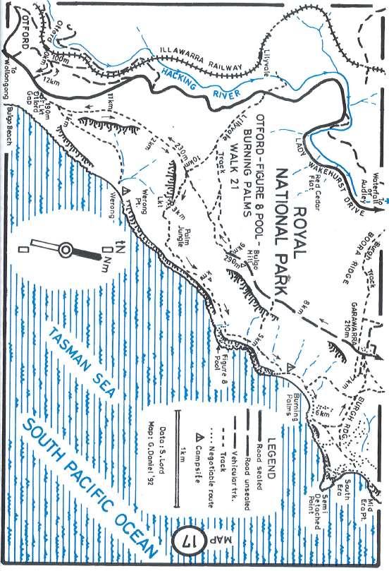
3 take the short side track on the right to a more compact but intricate set of engravings depicting human figures and wallabies. Return to the car and drive to the West Head Lookout and the far north-eastern end of West Head Road. Take a break and enjoy the panoramic view over Broken Bay, Barrenjoey and Pittwater here. Next drive back along West Head road for about 2km km to a car-park on the right of the road. Walk through the car-park and take the track which heads off in a NW direction. At a junction, turn right at the sign to Flint and Steele Bay (White Horse Beach). The track descends fairly steeply to a lovely sandy beach with delightful rock platforms worth exploring on both sides. Take a break here, before returning to the car park on West Head Road. Grade: Easy /medium, 160m asc. Distance: 2 km. ROYAL N.P.: OTFORD - BURNING PALMS - GARAWARRA - OTFORD Set in Australia's oldest national park (dedicated in 1879), this walk features panoramic coastal views, littoral rainforest and a beautiful ocean beach. The walk starts at Otford Gap. If coming by train, alight at Otford and take the track that leads off from the eastern side of the station and heads east uphill. Where the track meets a road, turn left and walk a short distance to Fanshawe Rd. Turn right up the hill, cross Lady Wakehurst Drive to Otford Gap. After admiring the extensive views, head north along the track for 300m, where there is a track fork. Take the left branch - the right branch leads to Werong Beach. Continue on this track through delightful bush to a second track junction (2km from Otford Gap). Take the right fork here to Burning Palms via Palm Jungle. After 300m there is a lookout on the cliff edge which offers panoramic views of the coastline as far south as Port Kembla. Continue on the track as it descends through the magnificent Palm Jungle - a large littoral rainforest area on the steep slopes above the ocean. Cabbage Tree Palms, vines, Birds Nest Ferns and Elkhorns are some of the beautiful rainforest plants found here in this unusual jungle community. Where the track emerges from the rainforest onto grassland (1.5km from the lookout above Werong Beach), walk north along the rock platform for 1km around two headlands to Burning Palms - an unspoilt ocean beach, backed by lush vegetation and an imposing escarpment. This is the recommended spot for lunch, a swim and a break. After lunch, walk to the northern end of the beach, and take the track that leads northwards among some huts for 600m to an open grassy area on the Burgh Ridge. From here, there are good views of Burning Palms to the south and South Era Beach to the north. Head west up the Burgh Ridge Track for 900m to the top of the escarpment and Garawarra picnic area and car-park - an ascent of 220m from the beach. At Garawarra, take the signposted Cliff Track which heads off SSW. This is a pleasant level track, but offers few views, even though it runs close to the cliff-edge. Ignore branch tracks to the left and right. At 2.5km from Garawarra car-park you arrive at the track branch encountered earlier in the day that leads to Burning Palms. Continue ahead (west) back to Otford Gap. Grade: Medium/Hard, 240m ascent Distance: 13km. Public Transport: Train to Otford.

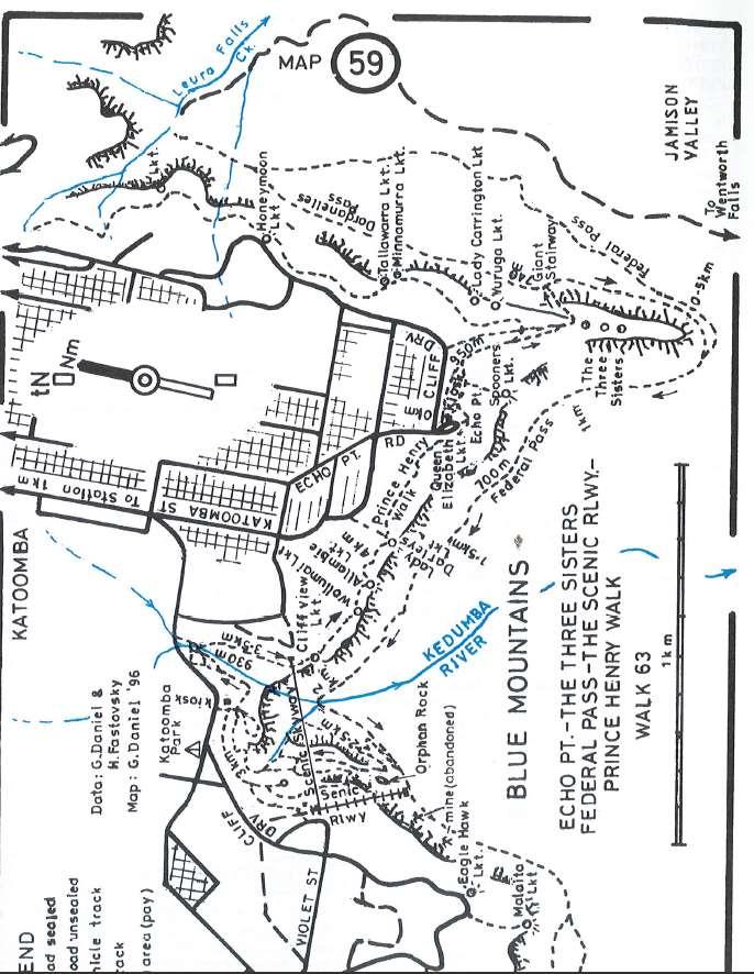
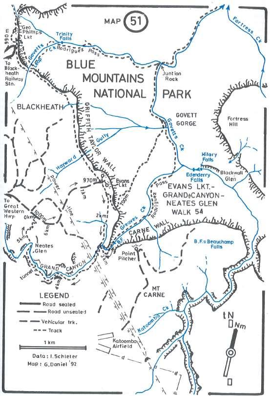
4 BLUE MOUNTAINS N.P.: ECHO PT - THE THREE SISTERS - FEDERAL PASS - THE SCENIC RAILWAY - PRINCE HENRY WALK Echo Point is perhaps the most famous lookout in Australia. The view of The Three Sisters and over the Jamison Valley and out to Kings Tableland in the east, Mt Solitary in the south, and Narrow Neck Peninsula to the west is rightly world famous. Tens of thousands of people visit this lookout every year but few venture far from the concrete paths nearby. This easy-medium walk takes you on a delightful circuit that includes marvellous lookouts and sections in temperate rainforest below the cliffs. A return to the cliff-tops via the scenic railway would make this an easygrade walk. Start from the northern side of the Information Centre/Kiosk at Echo Point by taking the path to The Three Sisters. These eroded sandstone pagodas, whose name is derived from an Aboriginal legend, are the last vestiges of a peninsula which juts out from the plateau. From the lookout at The Three Sisters head down The Giant Stairway which descends to the foot of the cliffface. Here, it meets a contouring track - Dardanelles Pass. Turn right (south) and follow Dardanelles Pass for 500m around the base of The Three Sisters to where it joins with the Federal Pass [track]. This track continues to contour below the cliff-line and heads north then NW through Coachwoods, Tree Ferns and other temperate rainforest plants. Take a break on the large rock slabs beside Kedumba Creek. Beyond Kedumba Creek the track turns SW. After 400m there is a branch-track on the right. You can take this convoluted track back up to the cliff-tops, but it is easier and more fun to continue on another 250m and ascend the 270m by catching the Scenic Railway. One back atop the cliff line, follow the track which heads generally NE through parkland and bush for 500m to a kiosk on Cliff Drive. From the western side of the kiosk, descend on a track to a 4-way junction, and turn left (east) onto the Prince Henry Walk. Follow it past The Cascades where it turns SSW to Echo Point. Along the way stop off and admire the marvelous views from Cliff View, Wollumai, Allambie and Lady Darlies Lookouts. Grade: Medium (if returning by scenic railway), 300m desc. Distance: 5km. Train to and from Katoomba Station, and taxi to and from Echo Point. BLUE MOUNTAINS N.P.: EVANS LOOKOUT - GRAND CANYON - NEATES GLEN Some of the most outstanding scenic features of the Blue Mountains are the deep canyons, although most are remote and very difficult to negotiate. The Grand Canyon, near Blackheath, is one of the few that is easily accessible with only medium grades. The track through the canyon is clearly defined and signposted and is a very popular walk. At Blackheath, take the Evans Lookout Road for 2.9km to a parking area on the right (about 1.3km short of Evans Lookout). There are signs "Neates Glen" and "Grand Canyon" at the trackhead here. Leave the car here. Walk along the road to Evans Lookout where there are spectacular views of the Govett Gorge. At the lookout there is a picnic area and shelter shed. Walk to the right hand side of the lookout and follow the track as it steeply descends. After 200m there is a track junction. Take the right branch which leads down to Greaves Creek and the Rodriguez Pass walking track - a descent of 270m from Evans Lookout. On the way down, as you pass through a lush rainforest with a canopy of Coachwoods, look for grey barked Sassafras, Lillypilly, giant ferns, thick mosses and tangled masses of vines and creepers.

5 At Greaves Creek there is a sign "Beauchamp Falls" pointing to the left, the right hand track leads to the Grand Canyon. Take the very pleasant short walk to the falls where you can sit atop huge boulders, have morning tea and enjoy the waterfall and surroundings. Return to the track junction and continue toward the Grand Canyon where you can see Greaves Creek flowing far below. In places the creek has cut a narrow chasm 30m deep and only a couple of metres wide right beside the track. You will see ferns, small waterfalls and moss covered overhangs. Floods have piled up logs and other debris in the creek. Along the way you will pass through a short tunnel and into an open area where there are Cedar Wattles. Cross Greaves Creek in Neates Glen and climb the steep track through Banksias, Tea Trees, Sydney Golden Wattle and Casuarinas to the parking area on Evans Lookout Road. Grade: Medium/Hard, 300m asc, steep and slippery in parts. Distance: 7km. Public Transport: Train to Blackheath. Note it is an extra 4.7km from Blackheath station to carpark on Evans Lookout Road.
6
7
8
9
Victoria Falls and Grose Valley to Blackheath Station
 This walk explores a fantastic section of the Grose Valley. Starting above Victoria Falls, the walk explores the cascades before dropping into the valley for the first nights rest at Burra Korain campsite.
Wentworth Pass. 893m. 535m. 4 hrs. Hard track 5.1 km Circuit. 692m
 Wentworth Pass 4 hrs Hard track 5.1 km Circuit 4 692m This walk offers a great way to explore the magical, upper section of the Valley of the Waters. The walk starts and finishes at Conservation Hut, which
National Pass. 893m. 665m. 3 hrs 30 mins 4.6 km Circuit. Hard track 773m. Blue Mountains National Park
 National Pass 3 hrs 3 mins 4.6 km Circuit Hard track 773m 4 This walk offers fantastic views of the Jamison Valley and the surrounding cliffs. Take time to explore the historic and very scenic ledge halfway
Leura to Katoomba via Dardanelles Pass
 Leura to Katoomba via Dardanelles Pass 4 hrs 6.6 km One way Hard track 697m With approximately equal parts cliff-walk and forest track, this track truly shows what the cliff edges of the Jamison Valley
Blackheath to Blue Gum loop
 Blackheath to Blue Gum loop 2 Days Hard track 24.1 km Circuit 4 1335m This walk is great for fit people getting into overnight walking, with its fantastic scenery and nostalgia as a classic overnighter.
Leura Cascades to Gordon Falls Reserve
 Leura Cascades to Gordon Falls Reserve 1 hr 15 mins 1.8 km One way Moderate track 200m From Leura Park to Gordon Falls Park, this diverse walk offers fantastic views of the Jamison Valley, as well as two
Nature Track. 900m. 789m. 2 hrs 3.1 km Circuit. Hard track 238m. Blue Mountains National Park
 Nature Track 2 hrs 3.1 km Circuit Hard track 238m Largely following the ridges around the top edge of Wentworth Falls, this track is incredibly beautiful. After taking in the great views at Edinburgh Castle
Illawarra Escarpment State Conservation Area Walking Tracks
 Illawarra Escarpment State Conservation Area Walking Tracks NPWS Illawarra Area Office Ground Floor, Government Office Block 84 Crown Street Wollongong NSW 2500 02 4223 3000 (Mon-Fri) Royal National Park
Scenic Railway to Ruined Castle
 Scenic Railway to Ruined Castle 7 hrs 30 mins 12.4 km Return Hard track 4 963m This is a very popular, full day walk, in the Katoomba Area, offering great views of the valley. The walk follows the edge
Victoria Falls Lookout to Blue Gum Forest
 Victoria Falls Lookout to Blue Gum Forest 8 hrs Experienced only 13.8 km One way 5 112m This long day-walk follows a remote track down from Victoria Falls lookout, passing the waterfall, and into the Grose
Great Ocean Road Two Day Tour
 www.greatoceanroad.vc Great Ocean Road Two Day Tour This two day trip of approximately 530 kilometre starts from Melbourne and provides a good overview of features along the Great Ocean Road between Anglesea
Victoria Falls and Grose Valley to Blackheath Station
 Victoria Falls and Grose Valley to Blackheath Station 3 Days Experienced only 22.5 km One way 5 158m This walk explores a fantastic section of the Grose Valley. Starting above Victoria Falls, the walk
Split Point Lighthouse Aires Inlet
 www.greatoceanroad.vc Great Ocean Road Three Day Tour 2 Night Stay This three day trip of approximately 730 kilometre starts from Melbourne and provides a good overview of features along the Great Ocean
Erskine Creek via Pisgah Rock and Jack Evans
 Erskine Creek via Pisgah Rock and Jack Evans 4 hrs 30 mins 7.1 km Circuit Very experienced only 6 421m This walk visits some great lookouts and explores the lower section of Erskine Creek. Most of the
Mt Kuring-gai Track to Berowra station
 Mt Kuring-gai Track to Berowra station 4 hrs 15 mins 9.7 km One way Hard track 4 553m This walk explores three valleys, with great displays of wild flowers in spring, and some nice sandstone overhangs.
Victoria Falls to Blackheath Station
 Victoria Falls to Blackheath Station 2 Days Experienced only 22.2 km One way 5 1561m This is a fantastic overnight walk with a sleep in Acacia Flats camping area. The Grose Valley, with its views of the
The Prince Henry Cliff Walk
 The Prince Henry Cliff Walk 3 hrs 30 mins 6.8 km One way Moderate track 3 575m Going from Katoomba to Leura, this walk covers the top of the cliff line and most of the major lookouts. With brilliant vistas
Katoomba to Wentworth Falls via the Jamison Valley
 Katoomba to Wentworth Falls via the Jamison Valley 2 Days Experienced only 29.2 km One way 5 2135m This is the two day version of this popular and challenging walk. This walk passes popular sights including
Dadder Cave and Jack Evans track
 Dadder Cave and Jack Evans track 2 Days 10.3 km Circuit Very experienced only 535m This fairly short overnight walk is a great way to explore Erskine Creek. The walking along Erskine creek is mostly off
DAY 1: Circular Quay to Greenwich Wharf
 DAY 1: Circular Quay to Greenwich Wharf Total Distance: 14km Time: Approximately 5 hours Walk Notes in Six Sections Section Name Length Time 1:1 Circular Quay to Milsons Point Station 2.5km 50mins 1:2
DAY 1: Emu Plains to Glenbrook Wednesday, January 2, 2019
 DAY 1: Emu Plains to Glenbrook Wednesday, January 2, 2019 Some sun: 34 C / 21 C 3mm Meeting time: 8.00am @ Our Lady of the Way Catholic Church, Emu Plains [15 Troy Street, Emu Plains; altitude: 32m] Mass:
Jerusalem Bay Track (Cowan to Brooklyn)
") Jerusalem Bay Track (Cowan to Brooklyn) 5 hrs 30 mins 13.4 km One way Hard track 4 654m This Cowan to Brooklyn Station walk is a popular section of the Great North Walk, with scenery ranging from foreshore
Jerusalem Bay Track (Cowan to Brooklyn) 5 hrs 30 mins 13.4 km One way Hard track 4 654m This Cowan to Brooklyn Station walk is a popular section of the Great North Walk, with scenery ranging from foreshore
Girrakool to Wondabyne station via Pindar caves
 Girrakool to Wondabyne station via Pindar caves 7 hrs 30 mins 18.1 km One way Experienced only 5 741m This walk starts from the Girrakool picnic area and winds south, following Piles creek into the Brisbane
ALL SPORTS ACTIVITIES ARE HIGHLIGHTED IN RED.
 Australia #3 Sports Tour Sydney & Cairns 12 Day / 9 Night Program www.victorysportstours.com SUGGESTED PROGRAM PLEASE NOTE: Actual sequence and timing of activities will revolve around your game & practice
Berowra to Cowan via Berowra Waters
 Berowra to Cowan via Berowra Waters 6 hrs Hard track 12.9 km One way 4 884m With train station at each end this walk explores the ridges and valleys around Berowra Waters. There are plenty of excellent
Crosslands to Cowan. 220m
 Crosslands to Cowan 7 hrs 30 mins 14 km One way Hard track 4 1103m This section of the Great North Walk starts from the Crosslands camping area and winds north alongside Berowra creek, passing through
Patonga to Staples Lookout
 Patonga to Staples Lookout 6 hrs 3 mins 17 km One way Hard track 4 72m This great walk explores much of the main ridge ridge running through Brisbane Water National Park. The walk visits a number of great
Patonga to Wondabyne station via Mt Wondabyne
 Patonga to Wondabyne station via Mt Wondabyne 7 hrs 3 mins 19.5 km One way Hard track 4 861m This walk explores some grand views, pleasant cascades, varied bushland and remote areas of Brisbane Waters
Gibberagong Track. 169m
 Gibberagong Track 2 hrs 30 mins 6.5 km One way Hard track 4 180m Starting in suburban Wahroonga, this wellmaintained track follows Cockle Creek down to Bobbin Head in the Ku-ring-gai Chase National Park.
Tiger Mountain State Forest:
 98 60 hikes within 60 miles: SEATTLE 20 Tiger Mountain State Forest: West Tiger Mountain Three Loop i KEY AT-A-GLANCE INFORMATION Length: 5.1 miles round-trip Configuration: Loop Difficulty: Moderate difficult
Crosslands to Berowra Waters return
 Crosslands to Berowra Waters return 6 hrs Hard track 13.7 km Return 4 1005m This return walk starts from the Crosslands Reserve and follows the Great North Walk along Berowra creek. The walk includes some
Self-Guided Walk Langdale Pikes. Start & Finish: NT car park (free to members) at Sticklebarn - on the right just beyond the New Dungeon Ghyll hotel.
 at Sticklebarn - on the right just beyond the New Dungeon Ghyll hotel.") Self-Guided Walk Langdale Pikes Key Information These mountains form a collection of spires and cliffs on the north side of Langdale. This walk visits four of the main tops Pavey Ark, Harrison Stickle,
Self-Guided Walk Langdale Pikes Key Information These mountains form a collection of spires and cliffs on the north side of Langdale. This walk visits four of the main tops Pavey Ark, Harrison Stickle,
Berowra Waters to Cowan Station
 Berowra Waters to Cowan Station 3 hrs 30 mins 7.2 km One way Hard track 597m This is a hilly walk out of the beautiful Berowra Waters valley to Cowan Station. There are many wide views across Berowra Creek
HARDMOORS 55 RACE ROUTE 2018 HELMSLEY - GUISBOROUGH
 HARDMOORS 55 RACE ROUTE 2018 HELMSLEY - GUISBOROUGH HELMSLEY - CHECKPOINT 1 (WHITE HORSE) 1. Leave RACE START, continue ahead on road (Baxtons Sprunt) At crossroads turn right down Canons Garth eventualy
Girrakool to Wondabyne station
 Girrakool to Wondabyne station 4 hrs Hard track 9.5 km One way 4 438m This walk starts from the Girrakool picnic area and winds south, through the Brisbane Waters National Park. The walk crosses some long
Crosslands to Brooklyn
 Crosslands to Brooklyn 2 Days Hard track 27.4 km One way 4 1757m From the Crosslands Reserve, this walk heads along the Great North Walk via Berowra Waters, Cowan, Jerusalem Bay and onto Brooklyn. This
Sponsored by. statestreet.com
 /STATESTREETISLANDWALK #ISLANDWALKJSY Sponsored by statestreet.com Important Information If you forget everything else PLEASE remember the following.» Remember to check OUT of every checkpoint» If you
GOLDEN EARS PROVINCIAL PARK
 GOLDEN EARS PROVINCIAL PARK Trail Information as of October 10 th 2015 Do not underestimate the mountainous wilderness of Golden Ears Provincial Park. The combination of rugged terrain and rapidly changing
Staples Lookout to Mt Wondabyne loop
 Staples Lookout to Mt Wondabyne loop 4 hrs 3 mins 1.8 km Circuit Hard track 337m This walk starts and finishes at Staples Lookout, on Woy Woy Rd. The walk follows sections of the Great North Walk around
GIFFORD PINCHOT NATIONAL FOREST
 GIFFORD PINCHOT NATIONAL FOREST 9341 Wright Meadow 93 Spencer Meadow Spencer Butte 4247' 30 30A 19 24 80 31C Lewis River Lower Falls 5 Quartz Creek 90 Taidnapam Falls Upper Falls 31 Spencer Peak 3861'
NOVEMBER WEDNESDAY 9 - TENERIFFE CIRCUIT
 NOVEMBER WEDNESDAY 1 st 9 am - TENERIFFE CIRCUIT This walk around the suburb of Teneriffe includes a track winding up through tall trees and vegetation to Teneriffe Park. Distance 7 km some uphill walking
CWMGIEDD FROM ABERCRAVE
 Abercrave to Cwmgiedd Walk Page 1 Starting from The Abercrave Inn. Grid Ref: SN 824128 From the Abercrave Inn, an 11.3km (7 miles) walk to the foothills of the Cribarth Mountain, then through forest to
C E N T R A L C A T S K I L L S
 120 C E N T R A L C A T S K I L L S Central Catskills Once out of the southern parts of the Catskills, the Long Path enters the more well traveled and civilized regions. The trail joins the Devil s Path,
Cowan to Wondabyne station via Patonga rest area
 Cowan to Wondabyne station via Patonga rest area 2 Days Hard track 33.4 km One way 4 1523m This section of the Great North Walk starts from Cowan train station and wanders past the majestic Jerusalem Bay
Berowra to Hornsby. 9 hrs 18 mins 22.6 km One way. Hard track. 1423m
 Berowra to Hornsby 9 hrs 18 mins 22.6 km One way Hard track 4 1423m One of the longer day walks in Berowra Valley National Park, this walk mostly follows Berowra Creek along the Great North Walk. Excellent
Congewai Track Head (East) to Watagan Headquarters
 to Watagan Headquarters") Congewai Track Head (East) to Watagan Headquarters 7 hrs Hard track 17.2 km One way 4 973m This full day walk starts from the Congewai valley trackhead (east) and follows the Great North Walk up into the
Congewai Track Head (East) to Watagan Headquarters 7 hrs Hard track 17.2 km One way 4 973m This full day walk starts from the Congewai valley trackhead (east) and follows the Great North Walk up into the
Hornsby station to Crosslands
 Hornsby station to Crosslands 6 hrs 45 mins 16.1 km One way Hard track 4 938m This section of the Great North Walk starts from Hornsby train station and winds down along the Blue Gum Walk into Fishponds.
COLOUR G U I D E. Sydney to Newcastle: Australia s most accessible long-distance walk
 COLOUR G U I D E Sydney to Newcastle: Australia s most accessible long-distance walk Woodslane Press Pty Ltd Unit 7/5 Vuko Place Warriewood, NSW 2102 Australia Email: info@woodslane.com.au Tel: (02)
beach. Make the ford and follow the trail out to the junction with Red Creek Tr in an open grassy area.
 Description: This is a moderate to slightly strenuous 22.8 mile backpack (add 2.6 miles if you do the packless out and back to the Lion s Head) that will have you exploring nearly every thing that is The
Looking north from the SW shieling site with Lub na Luachrach in the foreground
 Looking north from the SW shieling site with Lub na Luachrach in the foreground Upper Gleann Goibhre - Shieling sites Two shieling sites in the upper reaches of the Allt Goibhre were visited and recorded
Leaden Boot Challenge ROUTE INSTRUCTIONS
 Leaden Boot Challenge ROUTE INSTRUCTIONS Section 1 Alstonefield to Ilam From the village hall car park turn R then L and pass through the village keeping to the R to enter Church Street. Pass the Church
middle left: Riversleigh fossils lower left: Constance Range images: Hj Preuss... Thx
 Upstreampaddle Summer 2008 18 middle left: Riversleigh fossils lower left: Constance Range images: Hj Preuss... Thx top right: road west of the Isa middle right: Constance Range lower right: rocky outcrop
Lady Carrington Drive
 Lady Carrington Drive 3 hrs 45 mins 9.7 km One way Moderate track 3 266m This walk follows the historic Lady Carrington Drive alongside the Hacking River. The old road is closed to traffic and provides
Beautiful Walks from the Blue Ball Inn
 Walk No. 5 RIVER VALLEYS AND MOOR Countisbury, Watersmeet, Hillsford Bridge, Cheriton, Shilstone Hill, Rockford and Chiselcombe. 8.5 MILES APPROX. Walking time four and a half hours approx. OS 1;25,000
Merritts Traverse. 1928m
 Merritts Traverse 3 hrs Hard track 5.8 km Circuit 4 167m This walk starts with a scenic journey to the top of the hill on the chairlift. Starting along Merritts Nature walk, this walk soon detours down
Wondabyne station to Somersby Store
 Wondabyne station to Somersby Store 10 hrs Hard track 26.2 km One way 4 1164m This walk, following a section of the Great North Walk, starts from the Wondabyne train station and winds north, into the Brisbane
Camp Jack Wright PERMANENT ORIENTEERING COURSE (2004)
") Camp Jack Wright PERMANENT ORIENTEERING COURSE (2004) WHAT IS ORIENTEERING? The skill which enables a person to navigate with a map. In the competitive sport, the winner is the person who finishes in the
Camp Jack Wright PERMANENT ORIENTEERING COURSE (2004) WHAT IS ORIENTEERING? The skill which enables a person to navigate with a map. In the competitive sport, the winner is the person who finishes in the
6 DAYS MACHAME ROUTES ON KILIMANJARO
 6 DAYS MACHAME ROUTES ON KILIMANJARO Day 1: Moshi Machame camp In the morning, we depart from our base hotel at approximately 8:00 AM for the Machame village where you begin the trek. From the park entrance
Printed in China by Designed by Coral Lee Main cover image: Broken Bay
 Woodslane Press Pty Ltd Unit 7/5 Vuko Place Warriewood, NSW 2102 Australia Email: info@woodslane.com.au Tel: (02) 9970 5111 Fax: (02) 9970 5002 http://travelandoutdoor.bookcentre.com.au First published
Gordon to Hornsby (overnight at Scout camp)
") Gordon to Hornsby (overnight at Scout camp) 2 Days Hard track 25.8 km One way 4 125m This overnight walk starts from Gordon train station and winds through bush filled valleys to Hornsby station. From
Gordon to Hornsby (overnight at Scout camp) 2 Days Hard track 25.8 km One way 4 125m This overnight walk starts from Gordon train station and winds through bush filled valleys to Hornsby station. From
Tumbler Ridge Global Geopark
 Tumbler Ridge Global Geopark WILDERNESS WATERFALLS These waterfalls are in remote locations, no trails exist, and GPS is required. Not every geosite needs a hiking trail. Providing ready access to all
SUGGESTED ITINERARIES
 SUGGESTED ITINERARIES With so much to explore we ve done the hard work for you and created some suggested itineries. Simply choose the one that best suits you and start your El Questro adventure. For further
THE THREE PEAKS OF TANZANIA
 THE THREE PEAKS OF TANZANIA Longido, Mt Meru, and Kilimanjaro in 13 days Day 1 Arrival Longido approx 10kms trekking FBA can arrange your flights to Nairobi or Kilimanjaro. If booking your own flights,
Kakadu Highlights No. 9: September 23 - October 6, 2018
 Kakadu Highlights No. 9: September 23 - October 6, 2018 Section 1: Barramundi Creek: September 23-26 We begin with a four to six hour, 350 kilometre drive from Darwin. The last 45 kilometres is on a 4WD
Bewl Water & the High Weald
 1 Bewl Water & the High Weald Stonegate station - Stonegate - Wallcrouch - Newbarn - Cousley Wood - Wood's Green - Wadhurst station Length: 9 ½ miles (15.3km) Underfoot: Large portions of this path are
Patonga to Wondabyne station via Pindar Caves overnight
 Patonga to Wondabyne station via Pindar Caves overnight 2 Days Experienced only 28.1 km One way 5 1164m This overnight hike starts from Patonga beach and winds along a section of the Great North Walk,
HARDMOORS ROUTE DESCRIPTION
 HARDMOORS 60 2016 ROUTE DESCRIPTION RACE START (GUISBOROUGH) - CHECKPOINT 2 (SALTBURN) DISTANCE 9 MILES CUT OFF TIME 1030 GRID REF OS 666 208 1. Leaving the Sea Cadets Hall, turn left onto the road and
Beautiful Walks from the Blue Ball Inn
 Walk No. 2 WINSTONS WALK Countisbury, Wind Hill, Watersmeet, Ash Bridge and Winston s path. 5 Miles approx. Walking time- Two and a half hours approx. (Not including Breaks) OS 1:25,000 Sheet 64/74 Lynton
S H A W A N G U N K R I D G E T R A I L
 214 Shawangunk Ridge Trail The Shawangunk Ridge Trail was originally conceived as a relocation of the Long Path from Harriman State Park to Minnewaska State Park. Now part of the Long Path system, the
Hiking Las Vegas.com
 Hike: Mt. Wilson via First Creek Canyon route Trailhead: First Creek marked Distance: 10 miles up and back Elevation gain: 3,400 feet Elevation of Peak: 7,070 feet Time: 7 to 9 hours (up and back) Difficulty:
Leaden Boot Challenge 2016 ROUTE INSTRUCTIONS
 Leaden Boot Challenge 2016 ROUTE INSTRUCTIONS Section 1 Alstonefield to Ilam (CP2) From the village hall car park turn R then L and pass through the village keeping to the R to enter Church Street. Pass
Pontfadog. Walk A. Walk A
 Walk A A Bird s eye view of the village 2km. (1 1 /2 miles); height gain 45m. (150ft) about 45 minutes. Six minutes walk along the main road towards Glyn Ceiriog reach a signpost to Llwynmawr. Take the
Matthiessen State Park Dells Area Hike
 90 Easy Hikes Close to Home At the south end of the hike, you ll climb on top of a mound left over from a former coal-mining operation in the park. Not far from Goose Lake Prairie, the town of Morris hosts
Ystwyth and Rheidol Bridleway Routes. Route 2:Llanilar Circular
 Ystwyth and Rheidol Bridleway Routes Route 2:Llanilar Circular Route overview and terrain: A long circle using connecting ridges with fine views to link the Rheidol and Ystwyth river valleys. The route
Magoebaskloof Hiking Trail
 Magoebaskloof Hiking Trail Location The Magoebaskloof Hiking Trail is near the town of Tzaneen in the Limpopo Province. How to get there To Woodbush Hut. From Gauteng, take the N1 North towards Polokwane
Hadleigh Castle and Chalkwell Oaze
 1 Hadleigh Castle and Chalkwell Oaze Benfleet station Hadleigh Park Hadleigh Castle Leigh-on-Sea Chalkwell station A short stroll through the lush woods of Hadleigh Park high above the Thames-side marshes,
Somersby to Yarramalong via Stringy Bark Point
 Somersby to Yarramalong via Stringy Bark Point 2 Days Hard track 26.7 km One way 4 1201m This section of the Great North Walk starts form the Somersby General Store and follows the Great North Walk north
Baggy Point, Croyde, North Devon
 Baggy Point, Croyde, North Devon A walk using the South West Coast Path that is likely to be suitable for people with impaired mobility or with a pushchair, wheelchair, or mobility scooter. The Coast Path
The Mendip Way. Route Directions and Maps Uphill to Wells
 The Mendip Way Route Directions and Maps Uphill to Wells Website: www.mendiphillsaonb.org.uk Email: mendip@mendiphillsaonb.org.uk Facebook & Twitter: @MendipHillsAONB Phone: 01761462338 1 Uphill to Loxton
It ensures s services including education and prevention work in
 Costa Rica Coast to Coast - Jungle Challenge What s New? As you ll may know in October 2016 SAFE@LAST joined Depaul UK and became part of the Depaul family. The merger of these two excellent organisations
COSTA BLANCA MOUNTAIN WALKERS - WALK DESCRIPTION. Visit for more walks descriptions in Spain
 COSTA BLANCA MOUNTAIN WALKERS - WALK DESCRIPTION Visit www.walksinspain.org for more walks descriptions in Spain Walk description originally prepared by:- Ralph Phipps Last Updated 25th Sep 2015 Title
Lake Wissota Access Locations within the LaFayette Township. By Chad Martin
 Lake Wissota Access Locations within the LaFayette Township By Chad Martin Anson/ Wissota Access Point # 1 Road: 195 th St. Associated Fire Numbers: 13294 Defining Characteristics: Forested from road
Out and about at Geehi
 Geehi Geehi Flats is a large area of flat floodplain on the banks of the Swampy Plains River. Located within Kosciuszko National Park, it is home to a popular campsite in summer for people wanting to enjoy
Abbotts Falls Walking Track
 Abbotts Falls Walking Track 3 hrs 7.3 km Circuit Hard track 329m This circuit takes you through both dry and moist forest, using a combination of walking trails and wider tracks. The side trip to the dammed
Hindhead, Keffolds Copse and Gibbet Hill
 point your feet on a new path, Keffolds Copse and Gibbet Hill Distance: 6 km=4 miles Region: Surrey Author: Schwebefuss Refreshments: Punch Bowl Café moderate walking Date written: 14-apr-2015 Last update:
TRAVEL WITH CHRIS BROWN
 TRAVEL WITH CHRIS BROWN THE KIMBERLEY: BUNGLE BUNGLES & MITCHELL FALLS Where can you really get away from it all without missing out on life s little luxuries? Chris finds out this week as he heads to
Access. Road from start point (W01) to campground (W56) Water Taxi Pick-up (W03)
 to campground (W56) Water Taxi Pick-up (W03)") WAIKAREMOANA GREAT WALK 260 Series Map: W18 Waikaremoana NZ Grid GPS: Geodetic Datum 1949 Topo50 Maps: BG39 Ruatahuna & BG40 Waikaremoana Gaps: on WGS84 Topo250 Map: Sheet 10 To get to START: Exit Taupo
WAIKAREMOANA GREAT WALK 260 Series Map: W18 Waikaremoana NZ Grid GPS: Geodetic Datum 1949 Topo50 Maps: BG39 Ruatahuna & BG40 Waikaremoana Gaps: on WGS84 Topo250 Map: Sheet 10 To get to START: Exit Taupo
Waterproof Debris Shelter
 Bushcraft Video Series: David Styles, creator of 'Deep Nature Mentoring' presents Waterproof Debris Shelter Transcript Of Video 1. How Do We Make A Debris Shelter? Today we are going to learn about how
COAST TO COAST RAINFOREST TREK
 COSTA RICA TREK TOUGH ABOUT THE CHALLENGE Our adventurous coast to coast rainforest trek involves crossing from Costa Rica's Pacific Coast to the Caribbean. Enroute we take in the country s highest active
HIKING IN THE CANADIAN ROCKIES
 HIKING IN THE CANADIAN ROCKIES Distance Time Elevation y MORAINE LAKE TRAILS THE ROCKPILE 0.8 km (0.5 mi) 20 min 30 m (98 ft) Located adjacent to the Lodge, the short interpretive trail up the Rock Pile
The gorges of Mohican Park in Ohio create a hiker's paradise Sunday, May 22, 2011 By Bob Downing, Akron Beacon Journal
 Pittsburgh Post-Gazette The gorges of Mohican Park in Ohio create a hiker's paradise Sunday, May 22, 2011 By Bob Downing, Akron Beacon Journal Bob Downing Big Lyons Falls drops 80 feet into a shady U-shaped
Skyline Drive Hogback Canon City
 Skyline Drive Hogback Canon City Direction to trailhead: From US 50, turn north onto 15th Street. At the traffic circle, continue north on 15th Street until it dead ends at Washington Street (about 1.5
Discover. Ashhurst Domain. Nature s Playground
 Discover Ashhurst Domain Nature s Playground Discover Step back into New Zealand, Aotearoa, of generations long gone. Discover lush natural surrounds echoing with rich birdsong in one of the Manawatu s
Darwin s gigantic blunder
 Trail Darwin s gigantic blunder Explore how ice shaped the landscape and why Charles Darwin made a nice mess of Glen Roy Time: 1hr 10 mins Distance: 2 miles Landscape: rural At Glen Roy a curious feature
Note: Coordinates are provided as Universal Transverse Mercator UTM Zone U21, North American Datum 1983 (NAD 83).
.") Northern Traverse Route Description The Northern Traverse (formerly the North Rim Traverse) is an unmarked and rugged backcountry hiking route. It is known be a demanding hike, because of its terrain and
Northern Traverse Route Description The Northern Traverse (formerly the North Rim Traverse) is an unmarked and rugged backcountry hiking route. It is known be a demanding hike, because of its terrain and
ABOUT THE PARKS NANTAHALA NATIONAL FOREST MOUNTAINS NATIONAL PARK CHEROKEE NATIONAL FOREST PISGAH NATIONAL FOREST GREAT SMOKY HIKING TRAILS
 ABOUT THE PARKS GREAT SMOKY MOUNTAINS NATIONAL PARK NANTAHALA NATIONAL FOREST CHEROKEE NATIONAL FOREST PISGAH NATIONAL FOREST GREAT SMOKY MOUNTAINS NATIONAL PARK Straddling the border between North Carolina
JOURNEY DOWN UNDER Designed by Professor Wade Watkins 10 days May 2016
 JOURNEY DOWN UNDER Designed by Professor Wade Watkins 10 days May 2016 College Study Tours JOURNEY DOWN UNDER INCLUDED ON TOUR Round-trip flights on major carriers; Full-time Tour Director; Air-conditioned
START - UPHILL BEACH. (tidal!) The West Mendip Way is route-marked with these round blue signs
 The West Mendip Way is route-marked with these round blue signs") START - UPHILL BEACH Start Times: 10:30 11:15 12:00 Please allow sufficient time to check in with the marshals Start on the beach at the high water line (tidal!) The West Mendip Way is route-marked with
START - UPHILL BEACH Start Times: 10:30 11:15 12:00 Please allow sufficient time to check in with the marshals Start on the beach at the high water line (tidal!) The West Mendip Way is route-marked with
TUPPER DESIGNATED ACCESS ROUTE
 TUPPER DESIGNATED ACCESS ROUTE 1 FOR ACCESS/EGRESS TO CONNAUGHT, LOOKOUT, STONE ARCH, PORTAL PATHS AND TUPPER TRAVERSE EGRESS Length: 2.6km Vertical Gain: +162m / -83m (Values are for access. For egress,
Friends of Southern Eyre Peninsula Parks. Bushwalking in Lincoln National Park
 Friends of Southern Eyre Peninsula Parks Bushwalking in Lincoln National Park Select your trail Trail Time* Distance Trail Notes Stamford Hill to Surfleet Cove 1 hour one way 2.7 km one way An ideal coastal