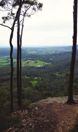
COLOUR G U I D E. Sydney to Newcastle: Australia s most accessible long-distance walk
|
|
|
- Ambrose Lyons
- 6 years ago
- Views:
Transcription

1 COLOUR G U I D E Sydney to Newcastle: Australia s most accessible long-distance walk
2
3
4 Woodslane Press Pty Ltd Unit 7/5 Vuko Place Warriewood, NSW 2102 Australia Tel: (02) Fax: (02) First published in Australia in 2012 by Woodslane Press Copyright 2012 Woodslane Press Pty Ltd; text and photographs 2012 Matt McClelland All rights reserved. Apart from any fair dealing for the purposes of study, research or review, as permitted under Australian copyright law, no part of this publication may be reproduced, distributed, or transmitted in any other form or by any means, including photocopying, recording, or other electronic or mechanical methods, without the prior written permission of the publisher. For permission requests, write to the publisher, addressed Attention: Permissions Coordinator, at the address above. Every effort has been made to obtain permissions relating to information reproduced in this publication. The information in this publication is based upon the current state of commercial and industry practice and the general circumstances as at the date of publication. No person shall rely on any of the contents of this publication and the publisher and the author expressly exclude all liability for direct and indirect loss suffered by any person resulting in any way from the use or reliance on this publication or any part of it. Any opinions and advice are offered solely in pursuance of the author s and publisher s intention to provide information, and have not been specifically sought. National Library of Australia Cataloguing-in-Publication entry Author:??? Title:???????? ISBN:???? Notes: Subjects:???? Dewey Number:???? Includes index. Printed in China by Bookbuilders Designed by Coral Lee
5
6
7
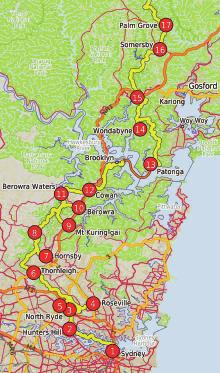
8 Walk Walk Walk KM Grade Ascent Decent Conditions highlights No time (hrs) 1 Sydney to Boronia Park Easy Mostly along streets and through a Sydney Harbour, historic monuments and buildings few small pockets of bushland 2 Boronia Park to North Ryde Easy - Med Mostly shaded bushland track Mangroves, Lane Cove River views along the tidal river bank 3 North Ryde Fairlands Circuit Medium Mix of shaded bushland and parkland, Fairlands, River views, Picnic areas, Boat shed some street walking 4 Roseville to Macquarie Park Medium Moslty dry shaded forest, side Lane Cove river views, sandstone caves, Blue hole of valley, some street walking 5 Macquarie Park to Thornleigh Medium Creek crossings, moist valleys Upper Lane Cove River, Conscript Pass, fern trees longer sections of trail 6 Thornleigh to Hornsby Medium Creek crossings, mostly walking plesent Zig Zag railway history, Walking alongside Berowra mostly dry forest, some steep sections and Waitara Creeks, sandstone caves 7 Hornsby to Galston Gorge Med Hard Creek crossings, steep hills, mostly Fishponds, Steele Bridge, Depression era stairs, open dry forest sandstone caves, Galston Gorge 8 Galston Gorge to Mt Kuring-gai Medium Some creek crossings, mostly walking Berowra Creek, Galston Gorge, Crosslands on narrow track through shaded forest area, Sandstone caves, plenty of good camping near valley floor, some hills 9 Mt Kuring-gai to Berowra Hard Some creek crossings, mostly walking Calna Creek, sandstone caves, water views, on narrow track through shaded forest Salt marsh near valley floor, some steep hills 10 Berowra to Berowra Waters Med - hard Some creek small crossings, mostly Naa Badu and other view points, water views, walking on narrow track through shaded wildflowers, Berowra Waters forest and more open ridge tops 11 Berowra Waters to Cowan Hard Several steep hills, creek crossings, Wide valley views, pleasant creeks, exposed rock platforms Scribbly gums, wildflowers 12 Cowan to Brooklyn Hard Several steep hills, creek crossings, Jerusalem Bay, Large Angophera s, Brooklyn dam, exposed rock platforms Brooklyn township 13 Patoonga to Wondabyne Hard Several steep hills, creek crossings, Warrah Lookout, Campsites, Mt Wondabyne, many exposed rock platforms, long Kariong Brook, Wondabyne section with no shade 14 Wondabyne to Mooney Med - hard Several steep hills, creek crossings, Large rock platforms, Scopas Peak, Piles Creek Mooney Creek trackhead many exposed rock platforms, long (suspension bridge), Mooney Mooney Creek section with no shade 15 Mooney Mooney Creek Med - hard Some creek crossings, mostly walking Mooney Mooney Creek, campsites, F3 bridge, Trackhead to Somersby on narrow track through shaded forest Lower Mooney Dam, Somersby Store near valley floor, some steep hills
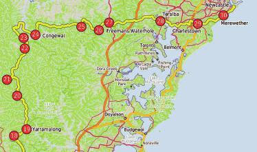
9 Walk Walk Walk KM Grade Ascent Decent Conditions Highlights No time (hrs) 16 Somersby to Ourimbah Med - hard Partly on road, some creek crossings, Palm Grove forest, pleasant creeks, Valley Trackhead mix of rainforest and dry bushland large fig trees 17 Ourimbah Valley Trackhead hard Partly on dirt road, some creek crossings, Secluded valley farmland, Ourimbah Creek, to Greta Rd mix of rainforest and dry bushland Dead Horse Creek 18 Brumble Hill Dray Track Medium Partly on country road, mix of moist and dry Historic dray track, pleasant rock walls, mostly (Greata Road to Yarramalong) forest, steep section following powerlines shaded forest, Yarramalong village 19 Yarramalong to Cedar Brush Easy Following rural roads, mostly sealed Pleasant rural valley 20 Cedar Brush to Basin Campsite Hard A few long sections of management trail, Wollombi Brook, Basin Campsite, mossy valleys some steep hills and small creek crossings 21 Basin Campsite to Watagan 6 13 Hard Section of narrow track through shaded Wollombi Brook crossing, mossy valleys, filtered Creek Road shaded forest, long sections of management views from ridge, Watagan Valley farming area trail, several steep hills and creek crossings 22 Watagan Creek Rd to Med - hard Steep climb, and section of walking Views from Flat Rock Lookout, pleasant farming Flat Rock Lookout along remote dirt road area and valley at start 23 Flat Rock Lookout to Congewai Medium Long section of rural roads, steep descent Views from Flat Rock Lookout, pleasant remote Valley East trackhead farming valley, wetlands 24 Congewai Valley East trackhead Med - hard Steep climb, and long section of walking Barraba campsite, loggers hut, Views from. to Watagan HQ along remote dirt road and trail cliffs along ridge top 25 Watagan HQ to Heaton Lookout Hard Creek crossings, moist valleys, Good lookouts, Wallis and other mossy reek very steep sections crossings, rock walls 26 Heaton Lookout to Heaton Gap Medium Mostly on remote dirt road and trail, Good views, grass trees wildflowers, motel/shop some steep sections 27 Heaton Gap to Teralba Med - hard Long section of roads and trails, some Sugarloaf Range, filtered views from ridge tops very steep sections of track, mostly dry forest 28 Teralba to Charlestown Easy Mostly walking on footpaths and roads with Lake Macquarie, Various parklands, icecream some sections through pockets of bushland. 29 Charlestown to Merewether Easy-Med Pleasant track through dry forest, exposed Glenrock Lagoon, Leichhardt s Lookout, ocean rock platform and sandy beach, Burwood Beach, Mereweather Baths small creek crossings 30 Merewether to Newcastle Easy Footpaths, road crossings, minimal shade. Ocean Views, Strzelecki Lookout, King Edwards Park, Obelisk, shops, The End
 to go down a few stone and then timber steps.")

10 From Boronia Park (at the intersection of Boronia Ave and Ryde Road), walk down along Boronia Avenue for just over 250 metres to the end of the road. Veer left, following the GNW arrow up along the rocky track. The track leads over a small rise then turns right (ignoring the track on the left) to go down a few stone and then timber steps. Continue along the bank of the Lane Cove River for about 100 metres before coming to Princes Street, with some open water views to the right. Turn left and head up the road for about 50 metres to an intersection with another track and a large green Great North Walk signpost. Turn right, following the Buffalo Creek Park arrow. After about 50 metres, veer right to follow the wide track through the casuarina forest to an intersection and a small clearing with a picnic table: the informally named Brickmakers Creek picnic area. Turn right, following the GNW arrow across the rocky Brickmakers Creek, and head up the timber steps and along the short timber boardwalk. The track continues up more steps for about 100 metres before flattening out and veering right at another GNW arrow post. Follow the track as it leads down between the rocks, offering a filtered view to the water, and veer right again at another GNW arrow post before heading gently down between some more rocks. For another 150 metres, the mostly flat track leads over some rock platforms and a short section of timber boarding to come to a three-way intersection marked with a GNW arrow, beside a larger, unfenced rock platform. Veer right and walk along the unfenced rock platform, keeping the river on the right. Walk down some steps carved in the rock and follow the rocky, sandy track gently downhill for about 140 metres, passing some rock formations to climb over some rocks with a metal handrail. Continue up a series of steps. Follow the rocky track down some more steps and alongside some mangroves to reach a T-intersection marked with a GNW arrow. (If the tide is low enough, you can take a short side-trip by turning right here and following the track along the raised mound through the tunnel of mangroves to a view of the river.) Turn left and follow the GNW arrow up the steps. The track

11 bends right then continues straight past the signposted Access to Barons Crescent track to follow the clear, GNW track. This flat, rocky track leads through the forest for about 300 metres before heading up some steps to a boulder outcrop with good views over the river. Continue for another 100 metres to a small clearing and a timber viewing platform on the right. This platform is near the confluence of the Lane Cove River and Buffalo Creek. The river is tidal, so the view of the mangrove community and eroded sandstone ruins is constantly changing. The track bends left and heads up the valley, keeping the Buffalo Creek mangroves on the right. Duck under a fallen tree and meander along the flat for about 120 metres to follow a short section of timber boardwalk. The track now leads up some steps to pass under a small sandstone overhang and along the base of a sandstone wall. Walk over a short section of timber boardwalk and onto a much longer section which winds through the wetlands, over a small creek and past the information sign on the friends of Buffalo Creek. The boardwalk winds among the paperbark trees and turns right onto the dirt track. Follow this dirt track for about 50 metres before heading up the timber ramp and turning right onto Pains Road. Continue straight to follow a GNW arrow along the wide, grassy track. After about 120 metres, walk up a grassy hill to find a large open parkland: Buffalo Creek Reserve. (To find the toilets, car park and playground, turn left here.) Turn right and follow the Great North Walk sign across the grass, passing a picnic table and fireplace to come to the Buffalo Creek Track Head signpost. Turn right and follow the Newcastle sign down three sets of timber stairs, then follow the timber boardwalk as it winds through the mangroves to a viewing area. Walk across Buffalo Creek on the bridge then climb up the stone steps to veer left at a faint intersection at the top of the steep climb, marked with a GNW arrow. The rocky track leads more gently up past the Lane Cove River National Park Sugarloaf Point sign to a T-intersection. Turn right, following the Sugarloaf Point sign along the flat, rocky and sandy track. The track bends left around the side of the hill, passing a few rock platforms along the way. Soon after heading down some stone steps is a T-intersection with a wide, sandy trail. There is a Buffalo Creek Reserve sign pointing back up the steps. (If you turn right here, you can walk 120 metres down to a pleasant open area beside Lane Cove River.) Turn left, following the Pittwater Road sign up along the wide trail, which soon becomes sealed. The trail passes a large, fenced, high-tension powerline concrete tower then heads around a locked gate to an intersection just before Pittwater Road, marked with a Great North Walk track sign. (There is also a small car park on Pittwater Road about 30 metres on the left.) Turn right, following the Great North Walk sign past the picnic table and down the timber steps, keeping Pittwater Road through the trees to the left. The track soon passes a Lane Cove National Park sign and heads down some

12 timber stairs, continuing just below the road and beside the mangroves for a little over 400 metres and crossing several timber platforms. The track heads up and down a few steps to reach a coastal wetlands information sign. It then heads away from the road, following a timber boardwalk as it winds through the mangroves and wetlands to cross Kitty Creek on a bridge. On the other side of the bridge is a T-intersection. Turn right, following the GNW arrow along the wide track which almost immediately bends left and follows the bank of the Lane Cove River through a casuarina forest. Here, the track starts edging away from the river and enters more dense vegetation before opening up and coming to a Lane Cove National Park Sugarloaf Point sign. Continue up along the grass and past the playing fields to find a GNW arrow post in front of the toilet block beside Magdala Park car park. Turn right, following the GNW arrow across the car park and through the gap in the fence, turning left to walk over the grass to the concrete footpath at the base of the large transmissions tower. Turn right, following the Newcastle sign down along the concrete footpath, then cross the Lane Cove River using the 150-metre footbridge. On the other side of the bridge, the footpath leads past the National Starch factory, winding around the edge of the fenced car park to come to the footpath beside Epping Road, just beside the traffic lights at Mowbray Road. (If you re peckish, there s a McDonalds about 250 metres along Epping Road at the Shell service station.) Continue downhill along the footpath towards the road bridge, crossing the factory driveway. A little over 100 metres past the driveway, follow the GNW arrow post past the steps and across the main bridge span for another 100 metres to find yet another set of stairs. Turn left to follow the GNW arrow post down the stairs and under the bridge. On the other side of the bridge, walk up a few steps and veer right following the Lane Cove National Park Fairyland Track sign down along the dirt track. This track soon leads down some timber steps, past a short rock wall and across two short, flat timber bridges. The walk continues up some steps and across a timber bridge with a handrail. The rocky track then leads downhill for about 100 metres before going gently up past the high-tension transmission tower to a signposted intersection just after the powerlines. (For the main spine of the Great North Walk, continue straight here, following the notes from waypoint 4 in walk 3.) Turn around and backtrack a few metres before veering right up towards the large corporate building. The track soon leads up to another intersection; veer right and head up the timber staircase past the 0.8km Scenic Trail arrow post. Walk up over a series of rocks and a few rock steps (ignoring a track on the right) for about 40 metres to pass an information sign on Aboriginal uses for plants. Continue up the stone steps, following a wire fence for almost 100 metres (behind the Honeywell building) to take one of the tracks that continue straight to the sealed road. Cross the road then turn right to follow the footpath alongside the road for about 150 metres before turning left onto Richardson Place. Follow this footpath uphill and cross Julius Avenue to the footpath on the other side. (About 80 metres to the left is the Village, a small shopping complex open Monday to Friday.) Turn right and follow the footpath gently up along Julius Avenue, leaving the Riverside Corporate Park and turning left onto the footpath beside Delhi Road. Follow the footpath (past a bus stop) and cross the other end of Julius Avenue at the traffic lights. Continue alongside Delhi Road for about 60 metres, past Delhi Convenience Store, to where the footpath leads to the entrance of North Ryde train station.
13


14 From Somersby Store, walk north downhill along Wisemans Ferry Road, past the public toilet. Cross an on-ramp and head over the bridge (crossing Peats Ridge Road), then cross another on-ramp. Continue along Wisemans Ferry Road for about 700 metres before taking a sharp right at the three-way intersection onto Dog Trap Road. Just over 100 metres on, turn left into Kilkenny Road and follow it past the rural properties for about 1.2 kilometres to the end of the sealed road. Walk along the dirt road to cross a sandstone ford that can be extremely slippery when wet. Continue up along the dirt road for another 300 metres to the end of the road and a Great North Walk sign, beside Illawong farm. Continue straight, following the Great North Walk sign along the management trail between the two farms. After about 300 metres, the trail leads to a clearing; turn right to follow the track along the fence line before turning left and following another Great North Walk sign down the hill. The track becomes progressively less steep as it leads down the ridge line until almost flattening out about 400 metres after the farm. The track then bends left and winds steeply down the side of the ridge, leading down a series of rock steps and into a dense, moist rainforest. The track passes some good examples of bird nest ferns (Asplenium australasicum) before the last little walk down and across the rocky creek. Follow the GNW arrow post up a series of rock steps. The track leads up past some large trees before turning right onto a leafy trail. Cross the creek then continue along the leafy trail for about 250 metres, turning left to follow the Great North Walk sign up along a narrow track. Just past a large strangler fig tree, the track begins to climb steeply up a series of rock steps and switchbacks, passing alongside a rock wall. Duck under a fallen tree and continue into the open forest, up more rock steps and switchbacks for another 250 metres. Here, the track flattens out and comes to the walker register tube. After leaving your comments, and having a read of other people s, turn right to follow the GNW arrow post along the top of the ridge and through a


15 clearing. Walk down along the top of the ridge to find a three-way intersection marked with a couple of GNW arrow posts. Turn left, following the GNW arrow post north-west off the side of the ridge. The track eventually leads down a series of rock steps, flattening out just before passing a tall strangler fig growing over a large boulder. Here the track winds more gently downhill to pass a couple of cabbage palms, then continues to wind fairly steeply down for another 400 metres before flattening out again. Near the end of this walk, the track leads through a short, weedy area, heading down an embankment to find Ourimbah Creek Road, marked with a large Ourimbah Valley Trackhead sign. (The main spine of the Great North Walk continues by turning left here and following the notes from waypoint 1 in walk 17.)
16
 to find a wide intersection at Cedar Ridge Road.")


17 From Flat Rock Lookout, follow the dirt road north-west, keeping the lookout on the right. After about 800 metres the road reaches a three-way intersection. Turn right and continue along the dirt road for about three kilometres (ignoring several side trails) to find a wide intersection at Cedar Ridge Road. Veer right and walk across the intersection to a large Great North Walk sign. Veer right, following the Congewai Valley sign uphill to the end of the road and the large Congewai Communication Tower. Continue straight, following the track and the GNW arrow marker to the right of the tower, to where the track bends right and leads steeply downhill. Continue on the rocky and eroded track for about 900 metres to find a level section where the track bends right. The track then undulates downhill for about 1.5 kilometres to pass an intersection marked with a Great North Walk sign. Walk up through the grassy open farmland for about 150 metres to a paddock gate with a fence to the right. Head through the gate and follow the trail as it undulates for about 450 metres, before crossing a small creek. About 60 metres further on, cross a fence using a stile beside a closed gate. Continue along the trail for another 200 metres to a sealed road. (If you have booked to stay at Lonely Goat Olives, turn left here and follow the side-trip notes.) Veer right and walk along the sealed Englinford Lane, which gently undulates through farmland. The road becomes unsealed after about 50 metres and continues for another 900 metres to a T-intersection with Congewai Valley Road, just after crossing a cattle grate. (To walk to the Paxton Pub, turn left here and follow the road for about 7.5 kilometres.) Turn right and follow the Barraba Trig sign south along the unsealed road. The walk continues undulating gently for about 4.4 kilometres to a timber bridge. Cross


18 and continue along the road through farmland for about 500 metres to a signposted intersection at the Congewai Valley East Trackhead, where a sign points back to Congewai and a stile sits to the left. Wetlands can also be seen off to the right. (To continue along the main spine of the Great North Walk, turn left and follow the notes from waypoint 1 in walk 24.)

19 gg Option Km Hrs Walks Sydney to North Ryde g3 Roseville to Thornleigh g5 Thornleigh to Hornsby Hornsby to Mt Kuring-gai g8 Mt Kuring-gai to Berowra Berowra to Cowan g11 Cowan to Brooklyn Patonga to Wondabyne Wondabyne to Somersby g15 Somersby to Yarramalong g18 Yarramalong to Basin Campsite g20 Basin Campsite to Watagan Creek Road Watagan Creek Road to Congewai Valley East Trackhead g23 Congewai Valley East Trackhead to Watagan HQ Watagan HQ to Heaton Gap g26 Heaton Gap to Teralba Teralba to Newcastle g30
20
21
22 C G
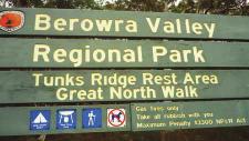
Mt Kuring-gai Track to Berowra station
 Mt Kuring-gai Track to Berowra station 4 hrs 15 mins 9.7 km One way Hard track 4 553m This walk explores three valleys, with great displays of wild flowers in spring, and some nice sandstone overhangs.
Somersby to Yarramalong via Stringy Bark Point
 Somersby to Yarramalong via Stringy Bark Point 2 Days Hard track 26.7 km One way 4 1201m This section of the Great North Walk starts form the Somersby General Store and follows the Great North Walk north
Somersby to the Basin Campsite
 Somersby to the Basin Campsite 3 Days Hard track 47.4 km One way 4 2032m This three day walk starts at the Somersby General Store and follows the Great North Walk, heading north, into the the Jilliby State
Crosslands to Cowan. 220m
 Crosslands to Cowan 7 hrs 30 mins 14 km One way Hard track 4 1103m This section of the Great North Walk starts from the Crosslands camping area and winds north alongside Berowra creek, passing through
Berowra to Cowan via Berowra Waters
 Berowra to Cowan via Berowra Waters 6 hrs Hard track 12.9 km One way 4 884m With train station at each end this walk explores the ridges and valleys around Berowra Waters. There are plenty of excellent
Wondabyne station to Somersby Store
 Wondabyne station to Somersby Store 10 hrs Hard track 26.2 km One way 4 1164m This walk, following a section of the Great North Walk, starts from the Wondabyne train station and winds north, into the Brisbane
Girrakool to Wondabyne station
 Girrakool to Wondabyne station 4 hrs Hard track 9.5 km One way 4 438m This walk starts from the Girrakool picnic area and winds south, through the Brisbane Waters National Park. The walk crosses some long
Berowra Waters to Cowan Station
 Berowra Waters to Cowan Station 3 hrs 30 mins 7.2 km One way Hard track 597m This is a hilly walk out of the beautiful Berowra Waters valley to Cowan Station. There are many wide views across Berowra Creek
Crosslands to Berowra Waters return
 Crosslands to Berowra Waters return 6 hrs Hard track 13.7 km Return 4 1005m This return walk starts from the Crosslands Reserve and follows the Great North Walk along Berowra creek. The walk includes some
Staples Lookout to Mt Wondabyne loop
 Staples Lookout to Mt Wondabyne loop 4 hrs 3 mins 1.8 km Circuit Hard track 337m This walk starts and finishes at Staples Lookout, on Woy Woy Rd. The walk follows sections of the Great North Walk around
Berowra to Hornsby. 9 hrs 18 mins 22.6 km One way. Hard track. 1423m
 Berowra to Hornsby 9 hrs 18 mins 22.6 km One way Hard track 4 1423m One of the longer day walks in Berowra Valley National Park, this walk mostly follows Berowra Creek along the Great North Walk. Excellent
Congewai Track Head (East) to Watagan Headquarters
 to Watagan Headquarters") Congewai Track Head (East) to Watagan Headquarters 7 hrs Hard track 17.2 km One way 4 973m This full day walk starts from the Congewai valley trackhead (east) and follows the Great North Walk up into the
Congewai Track Head (East) to Watagan Headquarters 7 hrs Hard track 17.2 km One way 4 973m This full day walk starts from the Congewai valley trackhead (east) and follows the Great North Walk up into the
Patonga to Wondabyne station via Mt Wondabyne
 Patonga to Wondabyne station via Mt Wondabyne 7 hrs 3 mins 19.5 km One way Hard track 4 861m This walk explores some grand views, pleasant cascades, varied bushland and remote areas of Brisbane Waters
Crosslands to Brooklyn
 Crosslands to Brooklyn 2 Days Hard track 27.4 km One way 4 1757m From the Crosslands Reserve, this walk heads along the Great North Walk via Berowra Waters, Cowan, Jerusalem Bay and onto Brooklyn. This
Patonga to Staples Lookout
 Patonga to Staples Lookout 6 hrs 3 mins 17 km One way Hard track 4 72m This great walk explores much of the main ridge ridge running through Brisbane Water National Park. The walk visits a number of great
Central Coast Hunter Range Region Discovery Program
 Central Coast Hunter Range Region Discovery Program Sydney to Newcastle General Inquiries NPWS (02) 4320 4200 (Monday - Friday) Detailed Information Anne Whyte, Discovery Coordinator NPWS (02) 4320 4205
Thornleigh to Cowan. 2 Days. Hard track 35.9 km One way. 2337m
 Thornleigh to Cowan 2 Days Hard track 35.9 km One way 4 2337m Following the Great North Walk and Berowra Creek through Berowra Valley Regional Park, this walk cuts straight through the length of the Park.
Cowan to Wondabyne station via Patonga rest area
 Cowan to Wondabyne station via Patonga rest area 2 Days Hard track 33.4 km One way 4 1523m This section of the Great North Walk starts from Cowan train station and wanders past the majestic Jerusalem Bay
Jerusalem Bay Track (Cowan to Brooklyn)
") Jerusalem Bay Track (Cowan to Brooklyn) 5 hrs 30 mins 13.4 km One way Hard track 4 654m This Cowan to Brooklyn Station walk is a popular section of the Great North Walk, with scenery ranging from foreshore
Jerusalem Bay Track (Cowan to Brooklyn) 5 hrs 30 mins 13.4 km One way Hard track 4 654m This Cowan to Brooklyn Station walk is a popular section of the Great North Walk, with scenery ranging from foreshore
Patonga to Wondabyne station via Pindar Caves overnight
 Patonga to Wondabyne station via Pindar Caves overnight 2 Days Experienced only 28.1 km One way 5 1164m This overnight hike starts from Patonga beach and winds along a section of the Great North Walk,
Girrakool to Wondabyne station via Pindar caves
 Girrakool to Wondabyne station via Pindar caves 7 hrs 30 mins 18.1 km One way Experienced only 5 741m This walk starts from the Girrakool picnic area and winds south, following Piles creek into the Brisbane
Printed in China by Designed by Coral Lee Main cover image: Broken Bay
 Woodslane Press Pty Ltd Unit 7/5 Vuko Place Warriewood, NSW 2102 Australia Email: info@woodslane.com.au Tel: (02) 9970 5111 Fax: (02) 9970 5002 http://travelandoutdoor.bookcentre.com.au First published
Hornsby station to Crosslands
 Hornsby station to Crosslands 6 hrs 45 mins 16.1 km One way Hard track 4 938m This section of the Great North Walk starts from Hornsby train station and winds down along the Blue Gum Walk into Fishponds.
Gordon to Hornsby (overnight at Scout camp)
") Gordon to Hornsby (overnight at Scout camp) 2 Days Hard track 25.8 km One way 4 125m This overnight walk starts from Gordon train station and winds through bush filled valleys to Hornsby station. From
Gordon to Hornsby (overnight at Scout camp) 2 Days Hard track 25.8 km One way 4 125m This overnight walk starts from Gordon train station and winds through bush filled valleys to Hornsby station. From
Gibberagong Track. 169m
 Gibberagong Track 2 hrs 30 mins 6.5 km One way Hard track 4 180m Starting in suburban Wahroonga, this wellmaintained track follows Cockle Creek down to Bobbin Head in the Ku-ring-gai Chase National Park.
Scenic Railway to Ruined Castle
 Scenic Railway to Ruined Castle 7 hrs 30 mins 12.4 km Return Hard track 4 963m This is a very popular, full day walk, in the Katoomba Area, offering great views of the valley. The walk follows the edge
Merritts Traverse. 1928m
 Merritts Traverse 3 hrs Hard track 5.8 km Circuit 4 167m This walk starts with a scenic journey to the top of the hill on the chairlift. Starting along Merritts Nature walk, this walk soon detours down
Victoria Falls and Grose Valley to Blackheath Station
 This walk explores a fantastic section of the Grose Valley. Starting above Victoria Falls, the walk explores the cascades before dropping into the valley for the first nights rest at Burra Korain campsite.
Abbotts Falls Walking Track
 Abbotts Falls Walking Track 3 hrs 7.3 km Circuit Hard track 329m This circuit takes you through both dry and moist forest, using a combination of walking trails and wider tracks. The side trip to the dammed
Leura Cascades to Gordon Falls Reserve
 Leura Cascades to Gordon Falls Reserve 1 hr 15 mins 1.8 km One way Moderate track 200m From Leura Park to Gordon Falls Park, this diverse walk offers fantastic views of the Jamison Valley, as well as two
Erskine Creek via Pisgah Rock and Jack Evans
 Erskine Creek via Pisgah Rock and Jack Evans 4 hrs 30 mins 7.1 km Circuit Very experienced only 6 421m This walk visits some great lookouts and explores the lower section of Erskine Creek. Most of the
Western Commission Track to Dubbo Gully
 This two day walk follows a series of historic roads along clear and wide management trails. This walk explores the great views from Western Commission Track, the sandstone handicraft on the Old Great
Victoria Falls Lookout to Blue Gum Forest
 Victoria Falls Lookout to Blue Gum Forest 8 hrs Experienced only 13.8 km One way 5 112m This long day-walk follows a remote track down from Victoria Falls lookout, passing the waterfall, and into the Grose
Nature Track. 900m. 789m. 2 hrs 3.1 km Circuit. Hard track 238m. Blue Mountains National Park
 Nature Track 2 hrs 3.1 km Circuit Hard track 238m Largely following the ridges around the top edge of Wentworth Falls, this track is incredibly beautiful. After taking in the great views at Edinburgh Castle
National Pass. 893m. 665m. 3 hrs 30 mins 4.6 km Circuit. Hard track 773m. Blue Mountains National Park
 National Pass 3 hrs 3 mins 4.6 km Circuit Hard track 773m 4 This walk offers fantastic views of the Jamison Valley and the surrounding cliffs. Take time to explore the historic and very scenic ledge halfway
Out and about at Geehi
 Geehi Geehi Flats is a large area of flat floodplain on the banks of the Swampy Plains River. Located within Kosciuszko National Park, it is home to a popular campsite in summer for people wanting to enjoy
Katoomba to Wentworth Falls via the Jamison Valley
 Katoomba to Wentworth Falls via the Jamison Valley 2 Days Experienced only 29.2 km One way 5 2135m This is the two day version of this popular and challenging walk. This walk passes popular sights including
Wentworth Pass. 893m. 535m. 4 hrs. Hard track 5.1 km Circuit. 692m
 Wentworth Pass 4 hrs Hard track 5.1 km Circuit 4 692m This walk offers a great way to explore the magical, upper section of the Valley of the Waters. The walk starts and finishes at Conservation Hut, which
Dadder Cave and Jack Evans track
 Dadder Cave and Jack Evans track 2 Days 10.3 km Circuit Very experienced only 535m This fairly short overnight walk is a great way to explore Erskine Creek. The walking along Erskine creek is mostly off
Guthega to Mt Twynam. 2183m. 1583m. 6 hrs 45 mins 14.8 km Return. Experienced only. 913m
 Guthega to Mt Twynam 6 hrs 45 mins 14.8 km Return Experienced only 5 913m This walk starts from Guthega and makes its way along the Snowy River to the Illawong Lodge, via the Blue Cow Creek flying fox.
Lady Carrington Drive
 Lady Carrington Drive 3 hrs 45 mins 9.7 km One way Moderate track 3 266m This walk follows the historic Lady Carrington Drive alongside the Hacking River. The old road is closed to traffic and provides
Leura to Katoomba via Dardanelles Pass
 Leura to Katoomba via Dardanelles Pass 4 hrs 6.6 km One way Hard track 697m With approximately equal parts cliff-walk and forest track, this track truly shows what the cliff edges of the Jamison Valley
Main Range Walk - Charlotte Pass to Mount Kosciuszko
 Main Range Walk - Charlotte Pass to Mount Kosciuszko 9 hrs Hard track 21.9 km Circuit 4 920m This full day walk explores some of the greatest alpine country on offer in NSW. The walk grants views of Blue,
The Mendip Way. Route Directions and Maps Uphill to Wells
 The Mendip Way Route Directions and Maps Uphill to Wells Website: www.mendiphillsaonb.org.uk Email: mendip@mendiphillsaonb.org.uk Facebook & Twitter: @MendipHillsAONB Phone: 01761462338 1 Uphill to Loxton
Guthega to Thredbo camping overnight at Wilkensons Creek
 Guthega to Thredbo camping overnight at Wilkensons Creek 2 Days Experienced only 25.8 km One way 5 1364m This great overnight walk explores the Kosciusko National Park between Guthega and Thredbo, visiting
Victoria Falls to Blackheath Station
 Victoria Falls to Blackheath Station 2 Days Experienced only 22.2 km One way 5 1561m This is a fantastic overnight walk with a sleep in Acacia Flats camping area. The Grose Valley, with its views of the
Victoria Falls and Grose Valley to Blackheath Station
 Victoria Falls and Grose Valley to Blackheath Station 3 Days Experienced only 22.5 km One way 5 158m This walk explores a fantastic section of the Grose Valley. Starting above Victoria Falls, the walk
Main Range Circuit from Guthega
 Main Range Circuit from Guthega 4 Days Experienced only 45 km Circuit 5 2317m This four day walk explores the Kosciuszko National Park, covering many of the key features of the park between Guthega and
Leaden Boot Challenge ROUTE INSTRUCTIONS
 Leaden Boot Challenge ROUTE INSTRUCTIONS Section 1 Alstonefield to Ilam From the village hall car park turn R then L and pass through the village keeping to the R to enter Church Street. Pass the Church
Blackheath to Blue Gum loop
 Blackheath to Blue Gum loop 2 Days Hard track 24.1 km Circuit 4 1335m This walk is great for fit people getting into overnight walking, with its fantastic scenery and nostalgia as a classic overnighter.
Leaden Boot Challenge 2016 ROUTE INSTRUCTIONS
 Leaden Boot Challenge 2016 ROUTE INSTRUCTIONS Section 1 Alstonefield to Ilam (CP2) From the village hall car park turn R then L and pass through the village keeping to the R to enter Church Street. Pass
Main Range Track - Loop from Charlotte Pass camping near Mt Townsend
 Main Range Track - Loop from Charlotte Pass camping near Mt Townsend 2 Days Experienced only 27.7 km Circuit 5 1260m This great overnight walk starts from Charlotte Pass and provides access to some of
The Queen Stage. 100, 200 & 300 Audax Rides - Saturday 22 nd July 2017
 The Queen Stage 100, 200 & 300 Audax Rides - Saturday 22 nd July 2017 A challenging course including most of the big climbs through Northern Sydney before heading north towards Yarramalong and returning
DAY 1: Circular Quay to Greenwich Wharf
 DAY 1: Circular Quay to Greenwich Wharf Total Distance: 14km Time: Approximately 5 hours Walk Notes in Six Sections Section Name Length Time 1:1 Circular Quay to Milsons Point Station 2.5km 50mins 1:2
The Prince Henry Cliff Walk
 The Prince Henry Cliff Walk 3 hrs 30 mins 6.8 km One way Moderate track 3 575m Going from Katoomba to Leura, this walk covers the top of the cliff line and most of the major lookouts. With brilliant vistas
Tiger Mountain State Forest:
 98 60 hikes within 60 miles: SEATTLE 20 Tiger Mountain State Forest: West Tiger Mountain Three Loop i KEY AT-A-GLANCE INFORMATION Length: 5.1 miles round-trip Configuration: Loop Difficulty: Moderate difficult
Slad over to Pitchcombe and back
 The walk climbs up from Slad over Wickridge Hill, descends to near Pitchcombe, then climbs back over Wickridge hill and round the back of Slad. Page 1 Start Point: SO 8718 0732 The Woolpack, Slad Length:
Hindhead, Keffolds Copse and Gibbet Hill
 point your feet on a new path, Keffolds Copse and Gibbet Hill Distance: 6 km=4 miles Region: Surrey Author: Schwebefuss Refreshments: Punch Bowl Café moderate walking Date written: 14-apr-2015 Last update:
Self-Guided Walk Langdale Pikes. Start & Finish: NT car park (free to members) at Sticklebarn - on the right just beyond the New Dungeon Ghyll hotel.
 at Sticklebarn - on the right just beyond the New Dungeon Ghyll hotel.") Self-Guided Walk Langdale Pikes Key Information These mountains form a collection of spires and cliffs on the north side of Langdale. This walk visits four of the main tops Pavey Ark, Harrison Stickle,
Self-Guided Walk Langdale Pikes Key Information These mountains form a collection of spires and cliffs on the north side of Langdale. This walk visits four of the main tops Pavey Ark, Harrison Stickle,
beach. Make the ford and follow the trail out to the junction with Red Creek Tr in an open grassy area.
 Description: This is a moderate to slightly strenuous 22.8 mile backpack (add 2.6 miles if you do the packless out and back to the Lion s Head) that will have you exploring nearly every thing that is The
Great Ocean Road Two Day Tour
 www.greatoceanroad.vc Great Ocean Road Two Day Tour This two day trip of approximately 530 kilometre starts from Melbourne and provides a good overview of features along the Great Ocean Road between Anglesea
Hiking Trail Descriptions
 Hiking Trail Descriptions For ye shall go out with joy. And be led forth with peace. The mountains and the hills shall break forth before you in singing. And all the trees of the fields shall clap their
Sponsored by. statestreet.com
 /STATESTREETISLANDWALK #ISLANDWALKJSY Sponsored by statestreet.com Important Information If you forget everything else PLEASE remember the following.» Remember to check OUT of every checkpoint» If you
Split Point Lighthouse Aires Inlet
 www.greatoceanroad.vc Great Ocean Road Three Day Tour 2 Night Stay This three day trip of approximately 730 kilometre starts from Melbourne and provides a good overview of features along the Great Ocean
SOUTH BANK TO NEW FARM PARK
 MAY TUESDAY 1 st 9am - SOUTH BANK TO NEW FARM PARK - Follow the path through South Bank Parklands and cross the Goodwill Bridge. Continue on the north bank of the river through the Botanic Gardens and
SATURDAY 2ND EARLY MORNING WALKS
 MARCH SATURDAY 2 ND 6 am - WHITES HILL LAGOON WALK a walk along the trail through bushland to the lagoon. Meet Corner Samuel Street & Boundary Rd, Camp Hill UBD Map 181 C 5 some uphill walking 7.30 am
CWMGIEDD FROM ABERCRAVE
 Abercrave to Cwmgiedd Walk Page 1 Starting from The Abercrave Inn. Grid Ref: SN 824128 From the Abercrave Inn, an 11.3km (7 miles) walk to the foothills of the Cribarth Mountain, then through forest to
middle left: Riversleigh fossils lower left: Constance Range images: Hj Preuss... Thx
 Upstreampaddle Summer 2008 18 middle left: Riversleigh fossils lower left: Constance Range images: Hj Preuss... Thx top right: road west of the Isa middle right: Constance Range lower right: rocky outcrop
Festum Prophetae. 200, 300, 400 & 600km Mixed Terrain Audax Rides Saturday 16 th & Sunday 17 th June 2018
 Festum Prophetae 200, 300, 400 & 600km Mixed Terrain Audax Rides Saturday 16 th & Sunday 17 th June 2018 Festum Prophetae or "The Festival of the Prophet" is a worldwide celebration of The Prophet, Eddy
Lake Wissota Access Locations within the LaFayette Township. By Chad Martin
 Lake Wissota Access Locations within the LaFayette Township By Chad Martin Anson/ Wissota Access Point # 1 Road: 195 th St. Associated Fire Numbers: 13294 Defining Characteristics: Forested from road
Walk 1. Cotswold Water Park. Gateway Centre to Cerney Wick, railway track to Lake 6, Gateway Centre.
 Cotswold Water ark Walk way A Swindon/ Cirencester Thomas and Severn Canal way to Cerney Wick, railway track to Lake, way. Spine Road East Hotel Time: hours (short walk km) Distance: km A level walk along
Wicklow Mountains Path Survey
 Wicklow Mountains Path Survey Ballinacor Croaghanmoira Fananierin Start to Finish: T 11723 86602 to T 11175 89057 Altitude (lowest highest): 385m 664m Weather: Hot Access: Coolgarrow forest entrance Surveyed
Walks in Sydney Stephen Lord
 Walks in Sydney Stephen Lord SYDNEY HARBOUR N.P.: MANLY TO THE SPIT The foreshore walking track from Manly to the Spit passes through sections of Sydney Harbour National Park and offers an opportunity
ROAD SCHOLAR SPRING HIKING ADVENTURE Tentative Schedule April 9-14, 2017
 ROAD SCHOLAR SPRING HIKING ADVENTURE Tentative Schedule April 9-14, 2017 Sunday, April 9 PM 3:00-5:00 Arrival, registration and move in to the dorm. 6:00 Supper EVE 7:15 Welcome & Orientation, Sign Ups
positively +flexible microsoft campus+ 1 Epping Road, North Ryde
 positively +flexible microsoft campus+ 1 Epping Road, North Ryde Space to suit your business+ Offering a selection of exceptional features, Microsoft Campus provides quality space to accommodate your business
Beautiful Walks from the Blue Ball Inn
 Walk No. 5 RIVER VALLEYS AND MOOR Countisbury, Watersmeet, Hillsford Bridge, Cheriton, Shilstone Hill, Rockford and Chiselcombe. 8.5 MILES APPROX. Walking time four and a half hours approx. OS 1;25,000
NOVEMBER WEDNESDAY 9 - TENERIFFE CIRCUIT
 NOVEMBER WEDNESDAY 1 st 9 am - TENERIFFE CIRCUIT This walk around the suburb of Teneriffe includes a track winding up through tall trees and vegetation to Teneriffe Park. Distance 7 km some uphill walking
Trail Phasing Plan. Note: Trails in the Clear Creek Canyon area (Segments will be finalized in the future to minimize wildlife impacts
 Note: Trails in the Clear Creek Canyon area (Segments 2 5 and a future JCOS connection) will be finalized in the future to minimize wildlife impacts Trail Phasing Plan P Parking 3 Easy Trail Intermediate
Reigate Hill and Gatton Park
 point your feet on a new path Reigate Hill and Gatton Park Distance: 11½ km=7 miles easy-to-moderate walking or 2 walks of 6½ km=4 miles and 5½ km=3½ miles Region: Surrey Author: Schwebefuss Refreshments:
BULIMBA, TENERIFFE CIRCUIT
 JUNE SATURDAY 2 nd 6.45 am - BULIMBA, TENERIFFE CIRCUIT Cross the river to Teneriffe and uphill through bushland with views from the top. Meet Bulimba Ferry, Oxford Street UBD Map 160 J 3 some uphill walking
Hadleigh Castle and Chalkwell Oaze
 1 Hadleigh Castle and Chalkwell Oaze Benfleet station Hadleigh Park Hadleigh Castle Leigh-on-Sea Chalkwell station A short stroll through the lush woods of Hadleigh Park high above the Thames-side marshes,
event map book SYDNEY 50KM SYDNEY 100KM
 event map book SYDNEY 50KM SYDNEY 100KM SATURDAY 25 SUNDAY 26 AUGUST 2018 BOBBIN HEAD TO THE HARBOUR FRIDAY 24 SUNDAY 26 AUGUST 2018 THE HAWKESBURY TO THE HARBOUR NATIONAL PARTNERS WWW.OXFAM.ORG.AU/TRAILWALKER
Ardingly Lake, Ouse Valley, Borde Hill
 point your feet on a new path Ardingly Lake, Ouse Valley, Borde Hill Distance: 14 km=9 miles or 12½ km=8 miles Region: West Sussex Author: Hautboy Refreshments: Borde Hill Map: Explorer 135 (Ashdown Forest)
This path goes past an old tree nursery and sawmill. After 800m it crosses over a lane. Follow the bridleway fingerpost into the woods.
 FRENSHAM PONDS 11K CIRCULAR TRAIL 2½ HRS GU10 2DA This magnificent heathland trail starts in woodland and then brings you out onto the open heather of Frensham Common, with no roadwork! The route runs
Britain s oldest surviving water-balanced cliff lift
 44 3.6 Saltburn by the Sea to Sandsend Map panels 3 and 4 Distance 17 miles (27½ km) Terrain mostly grass and field paths which can be muddy; some pavement, beach and shore Grade undulating route, with
Ystwyth and Rheidol Bridleway Routes. Route 2:Llanilar Circular
 Ystwyth and Rheidol Bridleway Routes Route 2:Llanilar Circular Route overview and terrain: A long circle using connecting ridges with fine views to link the Rheidol and Ystwyth river valleys. The route
Lava Mountain Trail Distance: Elevation Range: Trail Type: Difficulty: Season: Driving Distance: Driving Time: USGS Maps: Pros Cons
 Lava Mountain Trail Distance: 13.4 miles (including the side trip to North Star Lake) Elevation Range: 5900'-8330' Trail Type: singletrack Difficulty: moderate Season: late June-October Driving Distance:
Bewl Water & the High Weald
 1 Bewl Water & the High Weald Stonegate station - Stonegate - Wallcrouch - Newbarn - Cousley Wood - Wood's Green - Wadhurst station Length: 9 ½ miles (15.3km) Underfoot: Large portions of this path are
Waiau Pass Track. (Map 92, 91, 90, 89, 88, 87)
") Waiau Pass Track (Map 92, 91, 90, 89, 88, 87) Southern Start Northern End Distance Time Track Standard Boyle Village St Arnaud Village 115.5km 5-8 days Tramping track At 1870m, Waiau Pass is the most likely
Waiau Pass Track (Map 92, 91, 90, 89, 88, 87) Southern Start Northern End Distance Time Track Standard Boyle Village St Arnaud Village 115.5km 5-8 days Tramping track At 1870m, Waiau Pass is the most likely
Wicklow Mountains Path Survey
 Wicklow Mountains Path Survey Glenmacnass Tonelagee Start to Finish: O 114 030 to O 085 016 Altitude (lowest highest): 370m 817m Weather: Sunny day, hot Access: Military Road, Glenmacnass Surveyed by:
Illawarra Escarpment State Conservation Area Walking Tracks
 Illawarra Escarpment State Conservation Area Walking Tracks NPWS Illawarra Area Office Ground Floor, Government Office Block 84 Crown Street Wollongong NSW 2500 02 4223 3000 (Mon-Fri) Royal National Park
BURGHCLERE PARISH RIGHTS OF WAY
 BURGHCLERE PARISH RIGHTS OF WAY Full descriptions compiled by Neill & Miggie Bruce All photos Miggie Bruce FP23 on Ridgemoor, looking south, with FP22 crossing by the bush FP1. From C183 Aldern Bridge
ROAD SCHOLAR SPRING HIKING ADVENTURE Tentative Schedule April 8-13, 2018
 Sunday, April 8 ROAD SCHOLAR SPRING HIKING ADVENTURE Tentative Schedule April 8-13, 2018 PM 3:00-5:00 Arrival, registration and move in to the dorm. 6:00 Supper EVE 7:00 Welcome & Orientation, Sign Ups
MAY. MONDAY 1 st Public Holiday Labour Day
 MAY MONDAY 1 st Public Holiday Labour Day TUESDAY 2 nd 10 am - BROWNS PLAINS, REGENTS PARK CIRCUIT This is a pleasant walk following the bikepaths through the parklands and natural bushland in Logan City.
TREK TO ANCIENT PETRA
 JORDAN TREK DEMANDING ABOUT THE CHALLENGE This challenging and adventurous trek takes us through unique landscapes in one of the friendliest countries in the world, ending at the impressive rock-hewn facades
IRON BARK and COLENSO HUTS 260 Series Map: 1:50, U21 NZ Grid GPS: Geodetic Datum 1949
 IRON BARK and COLENSO HUTS 260 Series Map: 1:50,000 260-U21 NZ Grid GPS: Geodetic Datum 1949 Topo50 Map: BK36 Taoroa Junction GPS: on WGS84 How to get to START: Exit Taupo on SH1 down the lake to Turangi
Key Information. Self-Guided Walk Corfe Castle to Swanage
 Self-Guided Walk Corfe Castle to Swanage A classic walk from the pretty village of Corfe Castle. Enjoy extensive views whilst walking along the wide ridge to the popular seaside town of Swanage, returning
HARDMOORS ROUTE DESCRIPTION
 HARDMOORS 60 2016 ROUTE DESCRIPTION RACE START (GUISBOROUGH) - CHECKPOINT 2 (SALTBURN) DISTANCE 9 MILES CUT OFF TIME 1030 GRID REF OS 666 208 1. Leaving the Sea Cadets Hall, turn left onto the road and
North District Plan OVERVIEW
 OUR GREATER SYDNEY 2056 Revised Draft North District Plan OVERVIEW Hornsby Hunter's Hill Ku-ring-gai Lane Cove Mosman Northern Beaches North Sydney Ryde Willoughby Snapshot of the North District today
Pre Trip Contact: Note: To all the phone numbers in Book 2 add the number 4 after the 07.
 Jan 2013 Page 1 of 7 The Bicentennial National Trail is a living trail and as such conditions and access details are continually changing. Some of the information in the update notes may have been provided