Jerusalem Bay Track (Cowan to Brooklyn)
|
|
|
- Jane Hampton
- 5 years ago
- Views:
Transcription


1 Jerusalem Bay Track (Cowan to Brooklyn) 5 hrs 30 mins 13.4 km One way Hard track 4 654m This Cowan to Brooklyn Station walk is a popular section of the Great North Walk, with scenery ranging from foreshore to ridge top lookouts. You will follow the Great North Walk from Cowan Station down to the picturesque Jerusalem Bay, then climb up over a series of ridges before descending into Brooklyn. This walk is a great one-way trip from station to station with numerous water views, including a circumnavigation of Brooklyn Dam whilst enjoying a wonderful diversity of flora along the way. 200m 4m Ku-ring-gai Chase National Park Maps, text & images are copyright wildwalks.com Thanks to OSM, NASA and others for data used to generate some map layers.

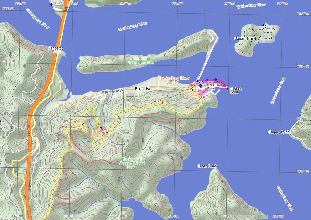
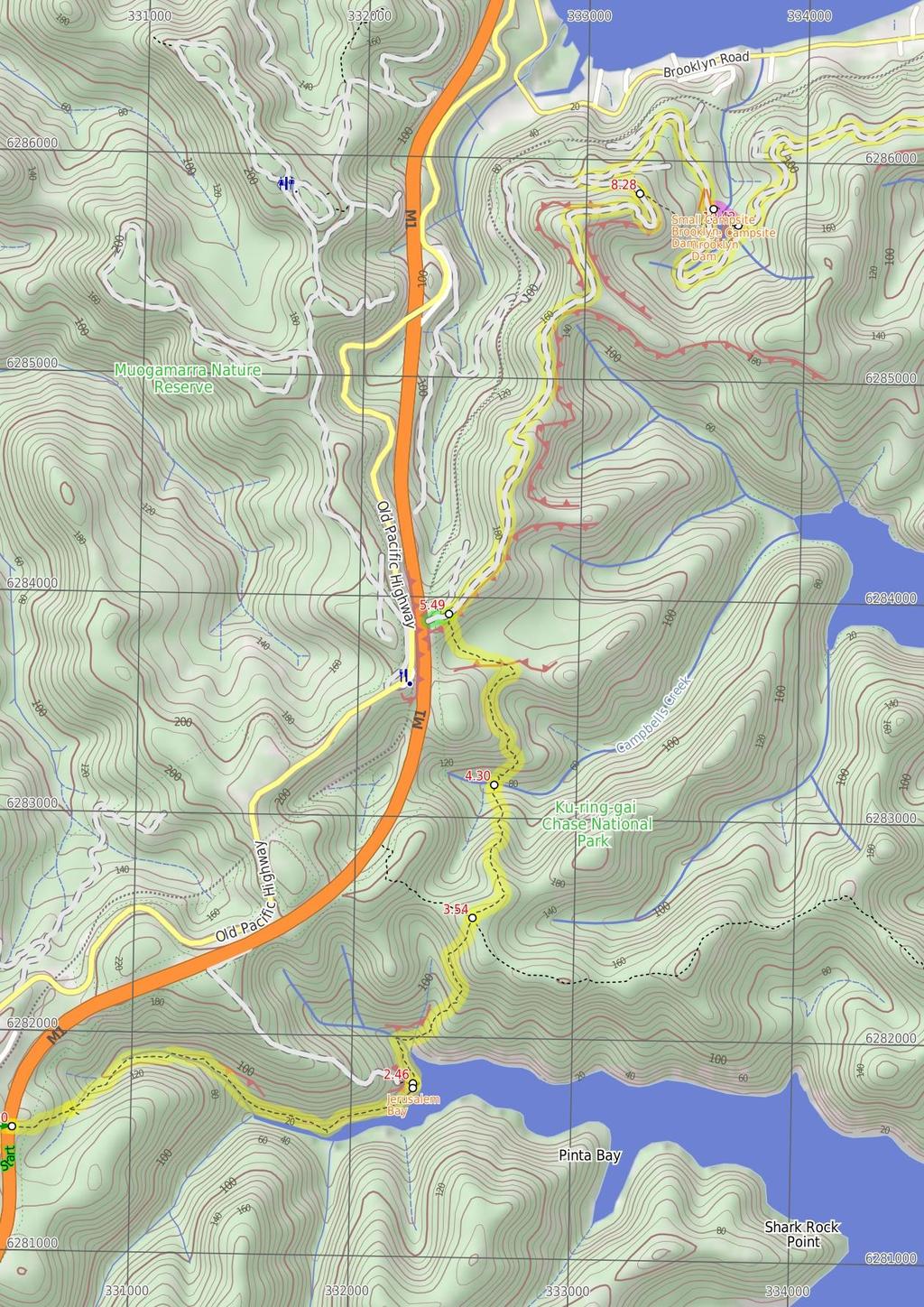
2 Jerusalem Bay Before You walk Jerusalem Bay, Ku-ring-gai National Park, is a nice bay east of Cowan Station. The bay is popular with bushwalkers as it is part of the Great North Walk. The bay is sometimes known for an iconic photo of the single palm in front of the water. The bay itself is also popular with boaters who can anchor in the bay. Jerusalem Bay can be accessed by the Hawkesbury River and Broken Bay or from Brooklyn or Cowan Railway Stations. Bushwalking is fun and a wonderful way to enjoy our natural places. Sometimes things go bad, with a bit of planning you can increase your chance of having an ejoyable and safer walk. Before setting off on your walk check Small Campsite Brooklyn Dam The small campsite next to Brooklyn Dam, Ku-ring-gai Chase National Park, is a small grassy campsite which has room for approximately four sites. The close proximity to Brooklyn Dam means close water. The campsite also has a few tall shady trees and is a fuel-stove only site. Large Campsite Brooklyn Dam The large campsite next to Brooklyn Dam, Ku-ring-gai Chase National Park, is a spacious and well-maintained campsite which has room for plenty of tents. The close proximity to the dam means accessible water (treat before drinking). The campsite has many tall, shady trees and is a fuel stove only site. The concrete dam wall was built in 1884 to provide water for the steam trains passing about 500m to the north. The dam was enlarged six times before 1924, then in in 1989 the dam was added to the expanded Ku-ring-gai Chase National Park. Brooklyn Accomodation Brooklyn is a lovely little village with plenty of holiday style accommodation. There are several small cafe/restaurants in the area, good choice for cooked meals. There are two options for overnight visits, both need to be booked in advance. Brooklyn Motel: Newly renovated accommodation on Bridge St,nearly opposite The Anglers Rest. This studio style accommodation starts from $120 per night with a spa, television and free wifi. Ph: or Breakfast can be organised for an extra fee. The Anglers Rest: Pub style accommodation on the intersection of Brooklyn & Dangar Rds. There are shared bathroom facilities. From $60 single and $90 a double. Breakfast not included (but you can grab breakfast from a cafe) PH:(02) ) Weather Forecast (BOM Metropolitan District) 2) Fire Dangers (Greater Sydney Region) 3) Park Alerts (Ku-ring-gai Chase National Park) 4) Research the walk to check your party has the skills, fitness and equipment required 5) Agree to stay as a group and not leave anyone to walk solo Think before you TREK The 'Think before you TREK' program developed by NSW Police & NPWS promotes the benefits of planning ahead for your bushwalking trip by using an easy to remember acronym: adequate supplies of food, water, navigation and first T Take aid equipment. your planned route and tell friends and family when R Register you expect to return. beacon (PLB's) should be carried on walks with E Emergency significant gaps in mobile coverage (check terrain profile). to your planned route and follow the map and walking K Keep trails. Topo Maps The maps provided on wildwalks are helpful, but there are times where you may need maps covering a broader area. Maps that cover this walk include; 1: Map Series:91304N COWAN 1: Map Series:CMA Ku-ring-gai Chase National Park Tourist Map 1: Map Series:9130 SYDNEY Grade This walk has been graded using the AS The overall grade of the walk is dertermined by the highest classification along the whole track. 4 Grade 4/6 Hard track Length 13.4 km One way Time 5 hrs 30 mins Quality of track Rough track, where fallen trees and other obstacles are likely (4/6) Signs Minimal directional signs (4/6) Experience Required Some bushwalking experience recommended (3/6) Weather Storms may impact on navigation and safety (3/6) Infrastructure Limited facilities (such as cliffs not fenced, significant creeks not bridged) (4/6)
3 Are you ready to have fun? Please ensure you and your group are well prepared and equipped for all possible hazards and delays. Check park closures, weather information and Fire Danger Rating before setting out. Optional side trips and alternate routes noted are not included in this walks overall grade, length or time estimate. Please allow extra time for resting and exploring areas of interest. The authors, staff and owners of wildwalks take care in preparing this information but will not accept responsibility for any inconvenience, loss or injury you may experience. Please take care, have fun - Happy Walking. Getting there You can get to Cowan Station (gps: , ) by car, train or bus. Car: There is free parking available. You can get back from Hawkesbury River Railway Station (gps: , ) by car, train or bus. Car: There is free parking available. Find up to date and more information inlcuding; travel directions, weather, park closures and walker feedback at 0 Cowan Station (300 m 6 mins) From the front of Cowan station, this walk follows the GNW arrow up the concrete ramp, turning right to cross the track at the controlled 'Pedestrian Railway Crossing'. The walk follows the ramp onto platform 1 (Sydney-bound side) then around the shelter to follow the GNW arrow post right, down the steps and through the gate. Here the walk crosses the train lines (train storage area) and turns left, following the 'Brooklyn' sign along the wide management trail. After 130m, the trail leads past an electrical switching area then turns right at the large 'Great North Walk' signposts. Here, the narrower trail leads between the fences over a small rise to cross the freeway on a large, fenced concrete bridge. 0.3 Freeway Bridge (2.2 km 50 mins) Continue straight: From the overpass, this walk heads away from the freeway and down the wide track. The track leads down a series of timber steps, then over a small rise (among the scribbly gums) where the track begins to narrow and lead more steeply down a rocky section. The walk then heads down a series of timber steps (passing a 'Great North Walk' sign), and crosses a short section of timber boardwalk. At the other end of the boardwalk, this track leads left over a rock platform (with a small creek flowing after rain) and then turns right to step off the rock platform. Continue straight: From the intersection, this walk heads downhill along the rocky track. The track leads past a few rock walls over about 350m, then turns right onto, then steps down off, a long thin rock platform. The track continues down along the side of the valley for another 200m, passing into a much more lush and dense forest, where the track then crosses the creek at a large rock platform. On the other side of the creek, the track leads right down along the other side of the valley, passing a few small sandstone overhangs then a particularly broad angophora tree after about 500m. Soon after this angophora, the track leads down some rock steps then begins to widen for about 300m, and passes a small track (on your right) marked with a 'No Camping or fires allowed' sign. By this point, the broad waters (or mud flats, depending on the tide) of Cowan Creek are obvious, on your right. The walk now continues along the generally broad and flat track for another 500m, then climbs up a set of concrete steps, marked with a GNW arrow post. At the top of these steps is a large, fairly flat clearing with a 'No Camping' and a 'Great North Walk' sign and a great view up the middle of Jerusalem Bay Jerusalem Bay Jerusalem Bay, Ku-ring-gai National Park, is a nice bay east of Cowan Station. The bay is popular with bushwalkers as it is part of the Great North Walk. The bay is sometimes known for an iconic photo of the single palm in front of the water. The bay itself is also popular with boaters who can anchor in the bay. Jerusalem Bay can be accessed by the Hawkesbury River and Broken Bay or from Brooklyn or Cowan Railway Stations Jerusalem Bay (1.1 km 37 mins) Continue straight: From the clearing at Jerusalem Bay, this walk follows the 'Great North Walk' sign, keeping the water to your right. The track bends left then leads down some sandstone steps (with a handrail). The track soon becomes fairly rough and follows the shoreline for about 200m before crossing a rocky and mossy gully. On the other side of this gully, the track tends right, following the GNW arrow post past a sandstone overhang, and over a small flat timber bridge. Just past this bridge, the track bends left and starts to climb steeply up the particularly rocky track. After about 300m of climbing, the track passes a small clearing with a small seat (on your right). Over the next 400m, the rocky track still heads up, but is generally less steep. The walk then comes to a large rock outcrop, where the track turns right to head up through a rocky gully. About 60m after this climb, the track leads up another short climb to a rock platform, then a third consecutive climb leads up through a crack in a rock to find a much welcomed bench seat and 'Great North Walk - Track Register' log book box. From here, the walk follows the the track gently uphill for another 60m to a 'Jerusalem Bay' sign pointing back along the track, at the top of the ridge Ridge Top (760 m 18 mins) Continue straight: From the top of the ridge, this walk follows the 'Brooklyn Dam' sign, gently uphill, heading north through the tall heath. The mostly flat track leads through the forest, with an occasional glimpse to the freeway and down to Brooklyn. after about 400m, the track bends left and leads through a long cleft in the rock. Here the track start to head more and more steeply down for the next 350m, until heading down some timber steps which lead to Campbells Creek. The walk steps over the small (orange, polluted ) creek to find a flat sandy clearing a few metres past the creek. 4.3 Campbells Ck (1.2 km 34 mins) Continue straight: From the small clearing, this walk follows the clear track away from the creek, and soon bends left then begins to climb. The rocky track climbs steeply for about 200m, passing among the grass trees and eucalyptus. The track flattens out and passes alongside a rock wall, then resumes the climb up the hill. At the top of this climb, the track passes a couple of small rock overhangs then climbs about halfway up a section of rock to follow the longer section of rock platform to the right. The track then gently undulates along the side of the hill, passing a section of hand rail after about 70m. The track then follows a series of small rock walls (on your left) for about 250m before climbing up onto a flat, sandy track. This soon leads to a faint intersection (with a track on your right, which goes to a large rock platform). From here, the sandy track stays mostly flat for about 300m before veering left at a GNW arrow post, leading up a more rocky section of track and then climbing up some steel pegs in the rock wall at the next GNW arrow post. Here the track leads up the short hill and comes to a T-intersection with a wide management trail, where a 'Jerusalem Bay' sign points back down the hill Optional sidetrip to freeway view point (100 m 2 mins) Turn left : From the intersection, this walk heads in the opposite direction to the 'Brooklyn' arrow, uphill along the wide management trail, keeping the power lines to your left. The trail leads through the tall heath and soon heads more steeply up a short hill to a concrete section of old road. The concrete section leads to the unfenced view point at the top of a large cutting, overlooking the freeway. At the end of this side trip, retrace your steps back to the main walk then Continue straight Int. Jerusalem Bay Trk and Brooklyn Dam Service Tr (2.8 km 57 mins) Turn right: From the intersection, this walk follows the 'Brooklyn' sign down along the wide management trail, initially keeping the power lines to your right. The trail gently undulates along the top of the ridge for about 700m, passing a few short side tracks (which lead to the power poles) and distant valley glimpses. The trail leads over a solid rock platform and less than 100m later, the walk leads past a track (on your right, which leads to a unfenced view over the valleys, from the power pole). The walk continues along the main trail for another 90m then follows a GNW arrow post as the trail bends left, then right, to head downhill notably steeply for a short time. The trail then continues to undulate along the top of the ridge for about 1.2km, passing more side tracks to power poles (some with unfenced views). The walk then comes to a point where the trail bends sharply right, and there is a filtered view over the Hawkesbury River to Peats Ferry Bridge. From here, the walk heads quiet steeply down for about 400m to pass under some power lines, where the trail then bends sharply left (enjoying some filtered views down to Brooklyn Dam and the Hawkesbury, on your right), passing under then same power lines again. The trail soon flattens out, coming to a faint three-way intersection (with a re-vegetating track on your right), marked with a 'Great North Walk' sign Upper Int. of Brooklyn Dam Service Track and Brook (1.3 km 28 mins) Continue straight: From the intersection, this walk follows the 'Great North Walk' sign along the wide management trail as it initially leads over a small rise then heads downhill, keeping the valley to your right. After about 300m, the trail turns sharp right at the T-intersection with another wide trail. This flat wide trail follows the power lines for about 250m to then veer left (at the Y-intersection), heading downhill away from the power lines. The trail leads downhill for just shy of 300m, passing the speed hump signs to then bend right at the large clearing (ignoring the fenced trail on your left). Then about 100m later, this walk ignores another fenced trail (on your left) as this trail is still bending right. Here the trail heads around the side of the hill for 400m to come to an intersection with a track (on your left, leading a few meters to the signposted campsite) marked with a GNW arrow post Small Campsite Brooklyn Dam The small campsite next to Brooklyn Dam, Ku-ring-gai Chase National Park, is a small grassy campsite which has room for approximately four sites. The close proximity to Brooklyn Dam means close water. The campsite also has a few tall shady trees and is a fuel-stove only site Alternate Route NW Brooklyn Dam Campsite to NE Bro (180 m 4 mins) Turn left: From this intersection, this walk follows the track east, away from the main trail and through the small 'Brooklyn Dam' campsite. On the other side of the campsite, the narrow track bends right and leads down into the gully, down a few concrete steps then heading alongside the small creek. Just before the dam wall, the track bends left, across the creek and up the short rocky hill to find a larger clearing. There is a good view over the dam (on your right). The track continues bending right through the clearing, and up a short hill to an intersection with the wide trail. Now Turn left to rejoin the main walk NW Brooklyn Dam Campsite intersection (790 m 15 mins) Continue straight: From the intersection, this walk follows the GNW arrows post south along the wide trail, soon passing alongside the dam (on your left). About 40m after passing edge of the dam wall, this walk comes to an intersection with a re-vegetating track (on your right) and a large 'Ku-ring-gai Chase National Park - Brooklyn Dam' sign (on your left). Continue straight: From the intersection, this walk follows the GNW arrow post along the wide trail, keeping the dam to your left. (This section of trail leads around to the far side of the dam.) After just over 250m, the trail crosses a small creek (at the apex of the dam) then continues bending left.

4 The track passes some old concrete pipes (on your left) then after about 400m, the trail comes to an intersection with a clearing and dam wall (to your left) Large Campsite Brooklyn Dam The large campsite next to Brooklyn Dam, Ku-ring-gai Chase National Park, is a spacious and well-maintained campsite which has room for plenty of tents. The close proximity to the dam means accessible water (treat before drinking). The campsite has many tall, shady trees and is a fuel stove only site. The concrete dam wall was built in 1884 to provide water for the steam trains passing about 500m to the north. The dam was enlarged six times before 1924, then in in 1989 the dam was added to the expanded Ku-ring-gai Chase National Park NE Brooklyn Dam Campsite (1.6 km 34 mins) Veer right: From the intersection, this walk follows the GNW arrow post uphill along the management trail, directly away from the dam. After about 30m, the trail bends right and passes a 'Ku-ring-gai Chase National Park - Brooklyn Dam' sign and continues uphill for another 150m, to where the trail becomes less steep (enjoying some filter views over the Hawkesbury on your left) for about 180m. Here a GNW arrow post guides along a short track (on the left), that runs parallel before re-joining the main trail again a short distance later. The walk then continues uphill to veer right at a three-way intersection, under the power lines, then about 120m later, this walk veers right again at another three-way intersection. About 70m up from here, the walk veers left at another three-way intersection, this time the trail generally follows the power lines along the side of the ridge. After another 300m, the trail bends right and passes under a set of high tension power lines, then continues to gently undulate for another 600m to come to a three-way intersection (with a clearing and trail on your left) and a 'Cowan' sign pointing back along the trail Int of Hawkesbury Track and Brooklyn Trail (1.1 km 25 mins) Continue straight: From the intersection, this walk follows the 'Brooklyn Station' sign gently downhill along the management trail, keeping the Hawkesbury River glimpses to your left. The trail gently undulates for about 600m before bending left to find a large clearing and water glimpses. From the clearing, the trail starts to lead downhill towards the water, and after nearly 100m, the trail leads steeply down a short section of concreted trail. Just after this, the trail leads steeply again over a longer section of concrete, where the trail then leads through a rock cutting to find an even longer and steeper section of concrete trail. This section of concrete leads down for about 220m, sweeping left to head around a locked gate, past a large 'Great North Walk' sign to find the southern end of William St. Here the walk turns right to head down William St then across George St to find a few 'Great North Walk' signs on the corner Alternate Route Int of George AND William Sts to H (1.3 km 24 mins) Turn right: From the intersection, this walk follows the 'Alternate Scenic Route' sign, crossing 'William St' and heading down alongside 'George Street'. After about 100m, this walk follows the 'Boat Launching Ramp' sign, veering left into the 'Parsley Bay' car park. This walk heads through the car park to follow the GNW arrow post up over the grassy verge and come to the Parsley Bay Boat Ramp. Turn left: From the boat ramp, this walk follows the GNW arrow post through the gate and along the dirt 'Parsley Bay' management trail, keeping the water to your right. The trail leads along the foreshore for about 250m then passes the 'Public Loading Dock' (just past a bench seat), and soon bends left around Flat Rock Point. The trail then leads past a square log seat, coming to an intersection (where there is a set of stairs on your left). Continue straight: From the intersection (at the base of the stairs), this walk follows the GNW arrow post along the wide flat trail, keeping the shoreline to your right. Enjoying the view over the water to Dangar Island, this dirt trail continues for just over 150m, passing a few seats to come to a concrete footpath beside a Brooklyn Baths. The footpath leads past the toilet block, then past several picnic shelters and comes to an intersection just before the fenced children's playground. Continue straight: From the intersection, this walk heads along the flat concrete footpath, keeping the water to your right. The path leads around the edge of the metal and glass 'Federation' interpretive signs and playground. Here the walk veers right to follow the gravel path between the car park (on your left) and the water (on your right) for about 130m before coming to the end of the car park. Turn left: From near the end of the car park, this walk follows the GNW arrow post across Dangar Rd to then turn right and follow the footpath. The footpath leads past the 'Hawkesbury River Marina', to cross a side street then pass some public toilets and a few cafes. The walk then leads past a small park to come to the sandstone 'Obelisk' commemorating the naming of the Hawkesbury River. This is just on the other side of the road, opposite some large 'Great North Walk' signs and the Hawkesbury River Railway Station. Now Turn sharp right to rejoin the main walk Int of George & William Sts (200 m 4 mins) Turn left: From the intersection, this walk follows the 'Great North Walk - Direct Route' sign gently uphill along the footpath beside George St. At the top of this hill, the walk turns right onto 'Bridge St' and heads down past a cafe, post office and 'The Anglers Rest' (on the other side of the road) and crosses 'Brooklyn Rd' to find a phone box on the other side Brooklyn Accomodation Brooklyn is a lovely little village with plenty of holiday style accommodation. There are several small cafe/restaurants in the area, good choice for cooked meals. There are two options for overnight visits, both need to be booked in advance. Brooklyn Motel: Newly renovated accommodation on Bridge St,nearly opposite The Anglers Rest. This studio style accommodation starts from $120 per night with a spa, television and free wifi. Ph: or Breakfast can be organised for an extra fee. The Anglers Rest: Pub style accommodation on the intersection of Brooklyn & Dangar Rds. There are shared bathroom facilities. From $60 single and $90 a double. Breakfast not included (but you can grab breakfast from a cafe) PH:(02) Int of Brooklyn AND Dangar Rds (90 m 1 mins) Continue straight: From the intersection, this walk follows the footpath down along Dangar Road past the phone box, keeping the train line and road to your left. The path soon leads past the community centre then the blue painted 'JJs Brooklyn' fish and chip store to come to the sandstone 'Obelisk' commemorating the naming of the Hawkesbury River. This is just on the other side of the road, opposite some large 'Great North Walk' signs and the Hawkesbury River Railway Station.
5
6
7 Summary navigation sheet for the Jerusalem Bay Track (Cowan to Brooklyn) km From 0.00 Cowan Station , (GR Cowan, ) Freeway Bridge , (GR Cowan, ) Jerusalem Bay , (GR Cowan, ) Ridge Top , (GR Cowan, ) Campbells Ck , (GR Cowan, ) Int. Jerusalem Bay Trk and Brooklyn Dam Service Trail , (GR Cowan, ) m 6 mins 2.2 km 50 mins 1.1 km 37 mins 760 m 18 mins 1.2 km 34 mins 100 m 2 mins From the front of Cowan station, this walk follows the GNW arrow up the concrete ramp, turning right to cross the track at the controlled 'Pedestrian Railway Crossing'. Continue straight: From the overpass, this walk heads away from the freeway and down the wide track Int. Jerusalem Bay Trk and Brooklyn Dam Service Trail , (GR Cowan, ) km 57 mins Turn right: From the intersection, this walk follows the 'Brooklyn' sign down along the wide management trail, initially keeping the power lines to your right Upper Int. of Brooklyn Dam Service Track and Brooklyn Dam Bushtrack , (GR Cowan, ) km 28 mins Continue straight: From the intersection, this walk follows the 'Great North Walk' sign along the wide management trail as it initially leads over a small rise then heads downhill, keeping the valley to your right NW Brooklyn Dam Campsite , (GR Cowan, ) NW Brooklyn Dam Campsite intersection , (GR Cowan, ) NE Brooklyn Dam Campsite , (GR Cowan, ) Int of Hawkesbury Track and Brooklyn Trail , (GR Cowan, ) Int of George AND William Sts , (GR Cowan, ) Int of George & William Sts , (GR Cowan, ) Int of Brooklyn AND Dangar Rds , (GR Cowan, ) m 4 mins 790 m 15 mins 1.6 km 34 mins 1.1 km 25 mins 1.3 km 24 mins 200 m 4 mins 90 m 1 mins Alternate Route NW Brooklyn Dam Campsite. Turn left: From this intersection, this walk follows the track east, away from the main trail and through the small 'Brooklyn Dam' campsite. Continue straight: From the intersection, this walk follows the GNW arrows post south along the wide trail, soon passing alongside the dam (on your left). Veer right: From the intersection, this walk follows the GNW arrow post uphill along the management trail, directly away from the dam. Continue straight: From the intersection, this walk follows the 'Brooklyn Station' sign gently downhill along the management trail, keeping the Hawkesbury River glimpses to your left. Alternate Route Int of George AND William Sts. Turn right: From the intersection, this walk follows the 'Alternate Scenic Route' sign, crossing 'William St' and heading down alongside 'George Street'. Turn left: From the intersection, this walk follows the 'Great North Walk - Direct Route' sign gently uphill along the footpath beside George St. Continue straight: From the intersection, this walk follows the footpath down along Dangar Road past the phone box, keeping the train line and road to your left Powered by TCPDF ( Up/Dwn Length Initial directions (Use full tracknotes and maps for more detail) Continue straight: From the clearing at Jerusalem Bay, this walk follows the 'Great North Walk' sign, keeping the water to your right. Continue straight: From the top of the ridge, this walk follows the 'Brooklyn Dam' sign, gently uphill, heading north through the tall heath. Continue straight: From the small clearing, this walk follows the clear track away from the creek, and soon bends left then begins to climb. Optional sidetrip to freeway view point. Turn left : From the intersection, this walk heads in the opposite direction to the 'Brooklyn' arrow, uphill along the wide management trail, keeping the power lines to your left.
Berowra Waters to Cowan Station
 Berowra Waters to Cowan Station 3 hrs 30 mins 7.2 km One way Hard track 597m This is a hilly walk out of the beautiful Berowra Waters valley to Cowan Station. There are many wide views across Berowra Creek
Mt Kuring-gai Track to Berowra station
 Mt Kuring-gai Track to Berowra station 4 hrs 15 mins 9.7 km One way Hard track 4 553m This walk explores three valleys, with great displays of wild flowers in spring, and some nice sandstone overhangs.
Congewai Track Head (East) to Watagan Headquarters
 to Watagan Headquarters") Congewai Track Head (East) to Watagan Headquarters 7 hrs Hard track 17.2 km One way 4 973m This full day walk starts from the Congewai valley trackhead (east) and follows the Great North Walk up into the
Congewai Track Head (East) to Watagan Headquarters 7 hrs Hard track 17.2 km One way 4 973m This full day walk starts from the Congewai valley trackhead (east) and follows the Great North Walk up into the
Victoria Falls Lookout to Blue Gum Forest
 Victoria Falls Lookout to Blue Gum Forest 8 hrs Experienced only 13.8 km One way 5 112m This long day-walk follows a remote track down from Victoria Falls lookout, passing the waterfall, and into the Grose
Berowra to Cowan via Berowra Waters
 Berowra to Cowan via Berowra Waters 6 hrs Hard track 12.9 km One way 4 884m With train station at each end this walk explores the ridges and valleys around Berowra Waters. There are plenty of excellent
Girrakool to Wondabyne station
 Girrakool to Wondabyne station 4 hrs Hard track 9.5 km One way 4 438m This walk starts from the Girrakool picnic area and winds south, through the Brisbane Waters National Park. The walk crosses some long
Cowan to Wondabyne station via Patonga rest area
 Cowan to Wondabyne station via Patonga rest area 2 Days Hard track 33.4 km One way 4 1523m This section of the Great North Walk starts from Cowan train station and wanders past the majestic Jerusalem Bay
Staples Lookout to Mt Wondabyne loop
 Staples Lookout to Mt Wondabyne loop 4 hrs 3 mins 1.8 km Circuit Hard track 337m This walk starts and finishes at Staples Lookout, on Woy Woy Rd. The walk follows sections of the Great North Walk around
Nature Track. 900m. 789m. 2 hrs 3.1 km Circuit. Hard track 238m. Blue Mountains National Park
 Nature Track 2 hrs 3.1 km Circuit Hard track 238m Largely following the ridges around the top edge of Wentworth Falls, this track is incredibly beautiful. After taking in the great views at Edinburgh Castle
Merritts Traverse. 1928m
 Merritts Traverse 3 hrs Hard track 5.8 km Circuit 4 167m This walk starts with a scenic journey to the top of the hill on the chairlift. Starting along Merritts Nature walk, this walk soon detours down
Erskine Creek via Pisgah Rock and Jack Evans
 Erskine Creek via Pisgah Rock and Jack Evans 4 hrs 30 mins 7.1 km Circuit Very experienced only 6 421m This walk visits some great lookouts and explores the lower section of Erskine Creek. Most of the
Crosslands to Brooklyn
 Crosslands to Brooklyn 2 Days Hard track 27.4 km One way 4 1757m From the Crosslands Reserve, this walk heads along the Great North Walk via Berowra Waters, Cowan, Jerusalem Bay and onto Brooklyn. This
Leura Cascades to Gordon Falls Reserve
 Leura Cascades to Gordon Falls Reserve 1 hr 15 mins 1.8 km One way Moderate track 200m From Leura Park to Gordon Falls Park, this diverse walk offers fantastic views of the Jamison Valley, as well as two
Abbotts Falls Walking Track
 Abbotts Falls Walking Track 3 hrs 7.3 km Circuit Hard track 329m This circuit takes you through both dry and moist forest, using a combination of walking trails and wider tracks. The side trip to the dammed
Crosslands to Berowra Waters return
 Crosslands to Berowra Waters return 6 hrs Hard track 13.7 km Return 4 1005m This return walk starts from the Crosslands Reserve and follows the Great North Walk along Berowra creek. The walk includes some
Guthega to Mt Twynam. 2183m. 1583m. 6 hrs 45 mins 14.8 km Return. Experienced only. 913m
 Guthega to Mt Twynam 6 hrs 45 mins 14.8 km Return Experienced only 5 913m This walk starts from Guthega and makes its way along the Snowy River to the Illawong Lodge, via the Blue Cow Creek flying fox.
Crosslands to Cowan. 220m
 Crosslands to Cowan 7 hrs 30 mins 14 km One way Hard track 4 1103m This section of the Great North Walk starts from the Crosslands camping area and winds north alongside Berowra creek, passing through
Gibberagong Track. 169m
 Gibberagong Track 2 hrs 30 mins 6.5 km One way Hard track 4 180m Starting in suburban Wahroonga, this wellmaintained track follows Cockle Creek down to Bobbin Head in the Ku-ring-gai Chase National Park.
Scenic Railway to Ruined Castle
 Scenic Railway to Ruined Castle 7 hrs 30 mins 12.4 km Return Hard track 4 963m This is a very popular, full day walk, in the Katoomba Area, offering great views of the valley. The walk follows the edge
Girrakool to Wondabyne station via Pindar caves
 Girrakool to Wondabyne station via Pindar caves 7 hrs 30 mins 18.1 km One way Experienced only 5 741m This walk starts from the Girrakool picnic area and winds south, following Piles creek into the Brisbane
Patonga to Staples Lookout
 Patonga to Staples Lookout 6 hrs 3 mins 17 km One way Hard track 4 72m This great walk explores much of the main ridge ridge running through Brisbane Water National Park. The walk visits a number of great
Dadder Cave and Jack Evans track
 Dadder Cave and Jack Evans track 2 Days 10.3 km Circuit Very experienced only 535m This fairly short overnight walk is a great way to explore Erskine Creek. The walking along Erskine creek is mostly off
Wentworth Pass. 893m. 535m. 4 hrs. Hard track 5.1 km Circuit. 692m
 Wentworth Pass 4 hrs Hard track 5.1 km Circuit 4 692m This walk offers a great way to explore the magical, upper section of the Valley of the Waters. The walk starts and finishes at Conservation Hut, which
National Pass. 893m. 665m. 3 hrs 30 mins 4.6 km Circuit. Hard track 773m. Blue Mountains National Park
 National Pass 3 hrs 3 mins 4.6 km Circuit Hard track 773m 4 This walk offers fantastic views of the Jamison Valley and the surrounding cliffs. Take time to explore the historic and very scenic ledge halfway
Patonga to Wondabyne station via Mt Wondabyne
 Patonga to Wondabyne station via Mt Wondabyne 7 hrs 3 mins 19.5 km One way Hard track 4 861m This walk explores some grand views, pleasant cascades, varied bushland and remote areas of Brisbane Waters
Victoria Falls to Blackheath Station
 Victoria Falls to Blackheath Station 2 Days Experienced only 22.2 km One way 5 1561m This is a fantastic overnight walk with a sleep in Acacia Flats camping area. The Grose Valley, with its views of the
Wondabyne station to Somersby Store
 Wondabyne station to Somersby Store 10 hrs Hard track 26.2 km One way 4 1164m This walk, following a section of the Great North Walk, starts from the Wondabyne train station and winds north, into the Brisbane
Hornsby station to Crosslands
 Hornsby station to Crosslands 6 hrs 45 mins 16.1 km One way Hard track 4 938m This section of the Great North Walk starts from Hornsby train station and winds down along the Blue Gum Walk into Fishponds.
Patonga to Wondabyne station via Pindar Caves overnight
 Patonga to Wondabyne station via Pindar Caves overnight 2 Days Experienced only 28.1 km One way 5 1164m This overnight hike starts from Patonga beach and winds along a section of the Great North Walk,
Victoria Falls and Grose Valley to Blackheath Station
 Victoria Falls and Grose Valley to Blackheath Station 3 Days Experienced only 22.5 km One way 5 158m This walk explores a fantastic section of the Grose Valley. Starting above Victoria Falls, the walk
Somersby to Yarramalong via Stringy Bark Point
 Somersby to Yarramalong via Stringy Bark Point 2 Days Hard track 26.7 km One way 4 1201m This section of the Great North Walk starts form the Somersby General Store and follows the Great North Walk north
Berowra to Hornsby. 9 hrs 18 mins 22.6 km One way. Hard track. 1423m
 Berowra to Hornsby 9 hrs 18 mins 22.6 km One way Hard track 4 1423m One of the longer day walks in Berowra Valley National Park, this walk mostly follows Berowra Creek along the Great North Walk. Excellent
Blackheath to Blue Gum loop
 Blackheath to Blue Gum loop 2 Days Hard track 24.1 km Circuit 4 1335m This walk is great for fit people getting into overnight walking, with its fantastic scenery and nostalgia as a classic overnighter.
Lady Carrington Drive
 Lady Carrington Drive 3 hrs 45 mins 9.7 km One way Moderate track 3 266m This walk follows the historic Lady Carrington Drive alongside the Hacking River. The old road is closed to traffic and provides
Somersby to the Basin Campsite
 Somersby to the Basin Campsite 3 Days Hard track 47.4 km One way 4 2032m This three day walk starts at the Somersby General Store and follows the Great North Walk, heading north, into the the Jilliby State
Main Range Walk - Charlotte Pass to Mount Kosciuszko
 Main Range Walk - Charlotte Pass to Mount Kosciuszko 9 hrs Hard track 21.9 km Circuit 4 920m This full day walk explores some of the greatest alpine country on offer in NSW. The walk grants views of Blue,
Leura to Katoomba via Dardanelles Pass
 Leura to Katoomba via Dardanelles Pass 4 hrs 6.6 km One way Hard track 697m With approximately equal parts cliff-walk and forest track, this track truly shows what the cliff edges of the Jamison Valley
Main Range Track - Loop from Charlotte Pass camping near Mt Townsend
 Main Range Track - Loop from Charlotte Pass camping near Mt Townsend 2 Days Experienced only 27.7 km Circuit 5 1260m This great overnight walk starts from Charlotte Pass and provides access to some of
Victoria Falls and Grose Valley to Blackheath Station
 This walk explores a fantastic section of the Grose Valley. Starting above Victoria Falls, the walk explores the cascades before dropping into the valley for the first nights rest at Burra Korain campsite.
The Prince Henry Cliff Walk
 The Prince Henry Cliff Walk 3 hrs 30 mins 6.8 km One way Moderate track 3 575m Going from Katoomba to Leura, this walk covers the top of the cliff line and most of the major lookouts. With brilliant vistas
Guthega to Thredbo camping overnight at Wilkensons Creek
 Guthega to Thredbo camping overnight at Wilkensons Creek 2 Days Experienced only 25.8 km One way 5 1364m This great overnight walk explores the Kosciusko National Park between Guthega and Thredbo, visiting
Katoomba to Wentworth Falls via the Jamison Valley
 Katoomba to Wentworth Falls via the Jamison Valley 2 Days Experienced only 29.2 km One way 5 2135m This is the two day version of this popular and challenging walk. This walk passes popular sights including
Gordon to Hornsby (overnight at Scout camp)
") Gordon to Hornsby (overnight at Scout camp) 2 Days Hard track 25.8 km One way 4 125m This overnight walk starts from Gordon train station and winds through bush filled valleys to Hornsby station. From
Gordon to Hornsby (overnight at Scout camp) 2 Days Hard track 25.8 km One way 4 125m This overnight walk starts from Gordon train station and winds through bush filled valleys to Hornsby station. From
Main Range Circuit from Guthega
 Main Range Circuit from Guthega 4 Days Experienced only 45 km Circuit 5 2317m This four day walk explores the Kosciuszko National Park, covering many of the key features of the park between Guthega and
Thornleigh to Cowan. 2 Days. Hard track 35.9 km One way. 2337m
 Thornleigh to Cowan 2 Days Hard track 35.9 km One way 4 2337m Following the Great North Walk and Berowra Creek through Berowra Valley Regional Park, this walk cuts straight through the length of the Park.
Western Commission Track to Dubbo Gully
 This two day walk follows a series of historic roads along clear and wide management trails. This walk explores the great views from Western Commission Track, the sandstone handicraft on the Old Great
COLOUR G U I D E. Sydney to Newcastle: Australia s most accessible long-distance walk
 COLOUR G U I D E Sydney to Newcastle: Australia s most accessible long-distance walk Woodslane Press Pty Ltd Unit 7/5 Vuko Place Warriewood, NSW 2102 Australia Email: info@woodslane.com.au Tel: (02)
Out and about at Geehi
 Geehi Geehi Flats is a large area of flat floodplain on the banks of the Swampy Plains River. Located within Kosciuszko National Park, it is home to a popular campsite in summer for people wanting to enjoy
beach. Make the ford and follow the trail out to the junction with Red Creek Tr in an open grassy area.
 Description: This is a moderate to slightly strenuous 22.8 mile backpack (add 2.6 miles if you do the packless out and back to the Lion s Head) that will have you exploring nearly every thing that is The
Hindhead, Keffolds Copse and Gibbet Hill
 point your feet on a new path, Keffolds Copse and Gibbet Hill Distance: 6 km=4 miles Region: Surrey Author: Schwebefuss Refreshments: Punch Bowl Café moderate walking Date written: 14-apr-2015 Last update:
The Mendip Way. Route Directions and Maps Uphill to Wells
 The Mendip Way Route Directions and Maps Uphill to Wells Website: www.mendiphillsaonb.org.uk Email: mendip@mendiphillsaonb.org.uk Facebook & Twitter: @MendipHillsAONB Phone: 01761462338 1 Uphill to Loxton
Leaden Boot Challenge ROUTE INSTRUCTIONS
 Leaden Boot Challenge ROUTE INSTRUCTIONS Section 1 Alstonefield to Ilam From the village hall car park turn R then L and pass through the village keeping to the R to enter Church Street. Pass the Church
Slad over to Pitchcombe and back
 The walk climbs up from Slad over Wickridge Hill, descends to near Pitchcombe, then climbs back over Wickridge hill and round the back of Slad. Page 1 Start Point: SO 8718 0732 The Woolpack, Slad Length:
Leaden Boot Challenge 2016 ROUTE INSTRUCTIONS
 Leaden Boot Challenge 2016 ROUTE INSTRUCTIONS Section 1 Alstonefield to Ilam (CP2) From the village hall car park turn R then L and pass through the village keeping to the R to enter Church Street. Pass
GOLDEN EARS PROVINCIAL PARK
 GOLDEN EARS PROVINCIAL PARK Trail Information as of October 10 th 2015 Do not underestimate the mountainous wilderness of Golden Ears Provincial Park. The combination of rugged terrain and rapidly changing
Sponsored by. statestreet.com
 /STATESTREETISLANDWALK #ISLANDWALKJSY Sponsored by statestreet.com Important Information If you forget everything else PLEASE remember the following.» Remember to check OUT of every checkpoint» If you
Wicklow Mountains Path Survey
 Wicklow Mountains Path Survey Ballinacor Croaghanmoira Fananierin Start to Finish: T 11723 86602 to T 11175 89057 Altitude (lowest highest): 385m 664m Weather: Hot Access: Coolgarrow forest entrance Surveyed
Printed in China by Designed by Coral Lee Main cover image: Broken Bay
 Woodslane Press Pty Ltd Unit 7/5 Vuko Place Warriewood, NSW 2102 Australia Email: info@woodslane.com.au Tel: (02) 9970 5111 Fax: (02) 9970 5002 http://travelandoutdoor.bookcentre.com.au First published
Bewl Water & the High Weald
 1 Bewl Water & the High Weald Stonegate station - Stonegate - Wallcrouch - Newbarn - Cousley Wood - Wood's Green - Wadhurst station Length: 9 ½ miles (15.3km) Underfoot: Large portions of this path are
Beautiful Walks from the Blue Ball Inn
 Walk No. 5 RIVER VALLEYS AND MOOR Countisbury, Watersmeet, Hillsford Bridge, Cheriton, Shilstone Hill, Rockford and Chiselcombe. 8.5 MILES APPROX. Walking time four and a half hours approx. OS 1;25,000
Tiger Mountain State Forest:
 98 60 hikes within 60 miles: SEATTLE 20 Tiger Mountain State Forest: West Tiger Mountain Three Loop i KEY AT-A-GLANCE INFORMATION Length: 5.1 miles round-trip Configuration: Loop Difficulty: Moderate difficult
Difficult Run Stream Valley Park
 Difficult Run Stream Valley Park The more intense mountain bikers have known about for Difficult Run for some time. Equestrians have known it longer. Eight miles of unpaved trail, the Rails to River Trail
Lake Wissota Access Locations within the LaFayette Township. By Chad Martin
 Lake Wissota Access Locations within the LaFayette Township By Chad Martin Anson/ Wissota Access Point # 1 Road: 195 th St. Associated Fire Numbers: 13294 Defining Characteristics: Forested from road
GRINDLEFORD GALLOP 2018
 GRINDLEFORD GALLOP 2018 Route Information The Grindleford Gallop follows a fixed 21 mile route through the lanes and paths of Derbyshire. All competitors must follow this route. An OS map of the area with
Hadleigh Castle and Chalkwell Oaze
 1 Hadleigh Castle and Chalkwell Oaze Benfleet station Hadleigh Park Hadleigh Castle Leigh-on-Sea Chalkwell station A short stroll through the lush woods of Hadleigh Park high above the Thames-side marshes,
DAY 1: Circular Quay to Greenwich Wharf
 DAY 1: Circular Quay to Greenwich Wharf Total Distance: 14km Time: Approximately 5 hours Walk Notes in Six Sections Section Name Length Time 1:1 Circular Quay to Milsons Point Station 2.5km 50mins 1:2
Walk 1. Cotswold Water Park. Gateway Centre to Cerney Wick, railway track to Lake 6, Gateway Centre.
 Cotswold Water ark Walk way A Swindon/ Cirencester Thomas and Severn Canal way to Cerney Wick, railway track to Lake, way. Spine Road East Hotel Time: hours (short walk km) Distance: km A level walk along
Map: Landranger #27 Forres and Nairn and 36 Grantown and Aviemore
 THE DAVA WAY This is a newly created long distance route that runs from Forres to Grantown, mostly following the old railway line. You will need to detour around a couple of sections that are not really
CWMGIEDD FROM ABERCRAVE
 Abercrave to Cwmgiedd Walk Page 1 Starting from The Abercrave Inn. Grid Ref: SN 824128 From the Abercrave Inn, an 11.3km (7 miles) walk to the foothills of the Cribarth Mountain, then through forest to
Self-Guided Walk Langdale Pikes. Start & Finish: NT car park (free to members) at Sticklebarn - on the right just beyond the New Dungeon Ghyll hotel.
 at Sticklebarn - on the right just beyond the New Dungeon Ghyll hotel.") Self-Guided Walk Langdale Pikes Key Information These mountains form a collection of spires and cliffs on the north side of Langdale. This walk visits four of the main tops Pavey Ark, Harrison Stickle,
Self-Guided Walk Langdale Pikes Key Information These mountains form a collection of spires and cliffs on the north side of Langdale. This walk visits four of the main tops Pavey Ark, Harrison Stickle,
Camp Jack Wright PERMANENT ORIENTEERING COURSE (2004)
") Camp Jack Wright PERMANENT ORIENTEERING COURSE (2004) WHAT IS ORIENTEERING? The skill which enables a person to navigate with a map. In the competitive sport, the winner is the person who finishes in the
Camp Jack Wright PERMANENT ORIENTEERING COURSE (2004) WHAT IS ORIENTEERING? The skill which enables a person to navigate with a map. In the competitive sport, the winner is the person who finishes in the
Illawarra Escarpment State Conservation Area Walking Tracks
 Illawarra Escarpment State Conservation Area Walking Tracks NPWS Illawarra Area Office Ground Floor, Government Office Block 84 Crown Street Wollongong NSW 2500 02 4223 3000 (Mon-Fri) Royal National Park
Britain s oldest surviving water-balanced cliff lift
 44 3.6 Saltburn by the Sea to Sandsend Map panels 3 and 4 Distance 17 miles (27½ km) Terrain mostly grass and field paths which can be muddy; some pavement, beach and shore Grade undulating route, with
Pontfadog. Walk A. Walk A
 Walk A A Bird s eye view of the village 2km. (1 1 /2 miles); height gain 45m. (150ft) about 45 minutes. Six minutes walk along the main road towards Glyn Ceiriog reach a signpost to Llwynmawr. Take the
Ardingly Lake, Ouse Valley, Borde Hill
 point your feet on a new path Ardingly Lake, Ouse Valley, Borde Hill Distance: 14 km=9 miles or 12½ km=8 miles Region: West Sussex Author: Hautboy Refreshments: Borde Hill Map: Explorer 135 (Ashdown Forest)
Hiking Trail Descriptions
 Hiking Trail Descriptions For ye shall go out with joy. And be led forth with peace. The mountains and the hills shall break forth before you in singing. And all the trees of the fields shall clap their
Walking Track Classification System Parks and Wildlife Service
 Appendix A Walking Track Classification Specifications Walking Track Classification System Parks and Wildlife Service This Walking Track Classification System is the outcome of a review of the track classifications
Marilla Reservoir to Chestnut Ridge via Marilla Trails and Bullis Hollow Trail east to west
 USGS topographic maps useful to this hike are the Bradford and Stickney 7.5 minute sectionals. These notes are designed to assist in identifying distance and location using geophysical and man-made characteristics
IRON BARK and COLENSO HUTS 260 Series Map: 1:50, U21 NZ Grid GPS: Geodetic Datum 1949
 IRON BARK and COLENSO HUTS 260 Series Map: 1:50,000 260-U21 NZ Grid GPS: Geodetic Datum 1949 Topo50 Map: BK36 Taoroa Junction GPS: on WGS84 How to get to START: Exit Taupo on SH1 down the lake to Turangi
Beaver Creek State Park
 GENERAL INFORMATION Name of Park/Forest/Facility: Beaver Creek State Park County: Columbiana (St. Clair Township) Address: 12816 Sprucevale Road (ie County Rd 428) (street #, city) East Liverpool, Ohio
HARDMOORS 55 RACE ROUTE 2018 HELMSLEY - GUISBOROUGH
 HARDMOORS 55 RACE ROUTE 2018 HELMSLEY - GUISBOROUGH HELMSLEY - CHECKPOINT 1 (WHITE HORSE) 1. Leave RACE START, continue ahead on road (Baxtons Sprunt) At crossroads turn right down Canons Garth eventualy
Reigate Hill and Gatton Park
 point your feet on a new path Reigate Hill and Gatton Park Distance: 11½ km=7 miles easy-to-moderate walking or 2 walks of 6½ km=4 miles and 5½ km=3½ miles Region: Surrey Author: Schwebefuss Refreshments:
event map book SYDNEY 50KM SYDNEY 100KM
 event map book SYDNEY 50KM SYDNEY 100KM SATURDAY 25 SUNDAY 26 AUGUST 2018 BOBBIN HEAD TO THE HARBOUR FRIDAY 24 SUNDAY 26 AUGUST 2018 THE HAWKESBURY TO THE HARBOUR NATIONAL PARTNERS WWW.OXFAM.ORG.AU/TRAILWALKER
San Miguel to Caserio de la Hoya Circular (San Miguel)
") Tenerife Sur: Short Walks Under 10 km San Miguel to Caserio de la Hoya Circular (San Miguel) Route Summary An informative and scenic walk back in time from San Miguel to below El Roque, overlooking the
Tenerife Sur: Short Walks Under 10 km San Miguel to Caserio de la Hoya Circular (San Miguel) Route Summary An informative and scenic walk back in time from San Miguel to below El Roque, overlooking the
DAY 3: Huntleys Point Wharf to Balmain East Wharf
 DAY 3: Huntleys Point Wharf to Balmain East Wharf Total Distance: 14.5km Time: Approximately 5 hours Walk Notes in Five Sections Section Name Length Time 3:1 Huntleys Point Wharf to Iron Cove Bridge 4km
1. Waterfall Gully Mt Lofty. 5 Of the Best Hikes in Adelaide
 Adelaide is a beautiful city, and one of the most incredible things about Adelaide is the quality of bushwalking available on the suburban fringe. It is surrounded by the Mt Lofty Ranges, and much of the
Premium Waterfront Land for Sale
 Premium Waterfront Land for Sale An opportunity has arisen for the astute investor to purchase one of the last remaining blocks of absolute waterfront land at Berowra Waters. Lot 3 Coba point features
BURGHCLERE PARISH RIGHTS OF WAY
 BURGHCLERE PARISH RIGHTS OF WAY Full descriptions compiled by Neill & Miggie Bruce All photos Miggie Bruce FP23 on Ridgemoor, looking south, with FP22 crossing by the bush FP1. From C183 Aldern Bridge
Hay Wood, Rowington and Baddesley Clinton - Warwickshire
 Hay Wood, Rowington and Baddesley Clinton - Warwickshire Starts at Lay-by alongside Hay Wood 2 hours 30 minutes 5.5miles 8.8km Leisurely ID: 0.683 Developed by: John Clift Checked by: Andy Page www.ramblersroutes.org
Fetcham Downs and Bocketts Farm A magical teashop walk
 point your feet on a new path Fetcham Downs and Bocketts Farm A magical teashop walk Distance: 3 km=2 miles or 4 km=2½ miles Region: Surrey Author: Fusszweig Refreshments: Bocketts Farm easy walking Date
ID: 283 Distance: 6.2 miles Height gain: 500 Metres Map: Explore OL 19 Contributor David and Chris Stewart
 Walkingworld Wild Boar Fell ID: 283 Distance: 6.2 miles Height gain: 500 Metres Map: Explore OL 19 Contributor David and Chris Stewart Features Birds, Great Views, Hills or Fells Description: Wild Boar
Telluride-to-Moab Alternative Singletrack Options
 Telluride-to-Moab Alternative Singletrack Options Day 1 Day 1 Alternate 1: Galloping Goose to Deep Creek. 18.4 miles, ascent 3,530ft, descent 1,388ft. This is fun, flowey, moderate to intermediate singletrack
Darwin s gigantic blunder
 Trail Darwin s gigantic blunder Explore how ice shaped the landscape and why Charles Darwin made a nice mess of Glen Roy Time: 1hr 10 mins Distance: 2 miles Landscape: rural At Glen Roy a curious feature
Trail Phasing Plan. Note: Trails in the Clear Creek Canyon area (Segments will be finalized in the future to minimize wildlife impacts
 Note: Trails in the Clear Creek Canyon area (Segments 2 5 and a future JCOS connection) will be finalized in the future to minimize wildlife impacts Trail Phasing Plan P Parking 3 Easy Trail Intermediate
Matthiessen State Park Dells Area Hike
 90 Easy Hikes Close to Home At the south end of the hike, you ll climb on top of a mound left over from a former coal-mining operation in the park. Not far from Goose Lake Prairie, the town of Morris hosts
A Publication of Friends of Sleeping Bear Dunes
 A Publication of Friends of Sleeping Bear Dunes 2014, Friends of Sleeping Bear Dunes, P.O. Box 545, Empire, MI 49630 www.friendsofsleepingbear.org info@friendsofsleepingbear.org Learn more about the Friends
COSTA BLANCA MOUNTAIN WALKERS - WALK DESCRIPTION. Visit for more walks descriptions in Spain
 Visit www.walksinspain.org for more walks descriptions in Spain Walk description originally prepared by:- Ralph Phipps Last Updated 15 th July 2016 Title of Walk Location of Start (include name of nearest
London to Oxford Trek map
 London to Oxford Trek map Route stats: 103.6 km (64.4 miles) with 800 metres of climbing Start time: 08:00-09:00am Checkpoints: Start - Spelthorne Leisure Centre TW18 1AJ Distance: 0km (0m) Leave here
Road log for railway features east of Thunder Bay
 Road log for railway features east of Thunder Bay Routes: Notes: Highway 101 from Chapleau to Wawa via Hawk Junction and Highway 17 (Trans Canada Highway "TCH") from Wawa to Thunder Bay On the TCH there
Listing of Campsites on the Manigotagan River
 Listing of Campsites on the Manigotagan River This document lists and describes the campsites along the Manigotagan River between Highway #314 and the government dock in the community of Manigotagan. The