Main Range Track - Loop from Charlotte Pass camping near Mt Townsend
|
|
|
- Lindsey Webster
- 5 years ago
- Views:
Transcription

1 Main Range Track - Loop from Charlotte Pass camping near Mt Townsend 2 Days Experienced only 27.7 km Circuit m This great overnight walk starts from Charlotte Pass and provides access to some of the best sights around the Kosciuszko National Park. Just a few of the features along this walk include reaching the summits of the two tallest peaks in Australia, looking down on some glacial lakes and crossing the famous Snowy River. 2222m 1716m Kosciuszko National Park Maps, text & images are copyright wildwalks.com Thanks to OSM, NASA and others for data used to generate some map layers.

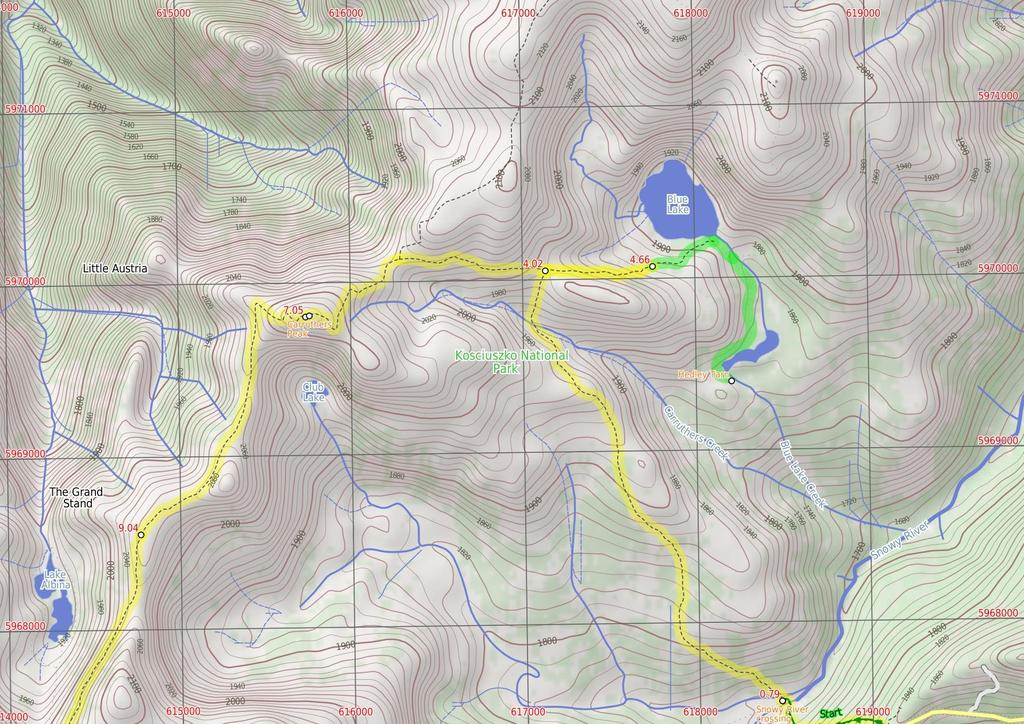
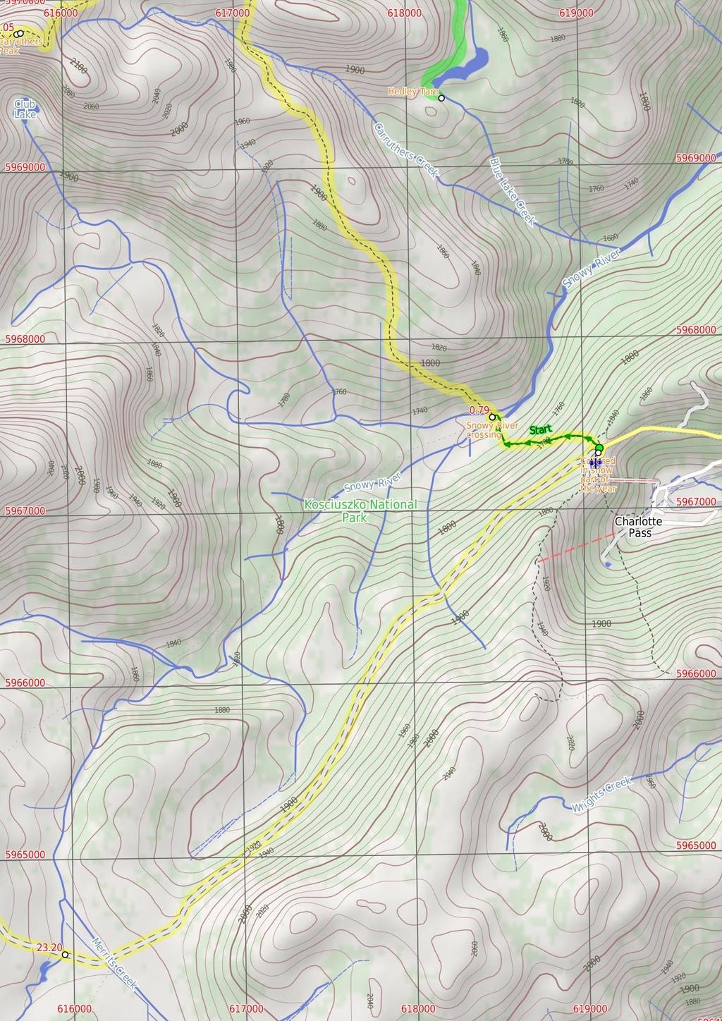
2 Covered in snow part of the year Before You walk This walk leads through an extreme alpine environment and all walkers must be well prepared. During summer, be prepared for both very hot and cold weather, high winds, rain, snow, extreme UV levels and some sections of snow or ice on the ground. Before starting this walk, check advice with Snowy Region Visitor Information Centre (02) , the weather forecast and the snow conditions then change your plans as needed. These notes, grades and walking times have been written for use in the summer months only. Between May and the end of October, this walk is likely to be covered in snow/ice, visitors should carry and be prepared to use snowshoes or cross country skis. When there is a chance of significant snow on the ground, visitors will need particularly strong navigation and snowcraft skills - tracks and signage may not be visible. For most visitors, it is best to consider this walk closed during the colder months. Between the long weekend in June and October, the road between Perisher Village and Charlotte Pass is closed by the RTA. It is possible to organise oversnow transport. Bushwalking is fun and a wonderful way to enjoy our natural places. Sometimes things go bad, with a bit of planning you can increase your chance of having an ejoyable and safer walk. Before setting off on your walk check Snowy River crossing At the lowest point of the the Main Range circuit track is the confluence (meeting) of the Snowy River and Club Lake Creek. The walking track uses stones in the river to try to get across with dry feet. Since the track crosses just above the confluence there is an 'island' halfway across. These creeks may become impassable after rain and snow melt. This is lovely place to rest and enjoy the water and valley. Hedley Tarn Hedley Tarn is a beautiful glacial lake just south of Blue Lake, from which you can see right across the valley to the end of Kosciuszko Road at Charlotte Pass and is well worth the trip down from Blue Lake. Carruthers Peak Carruthers Peak is a prominent mountain that is found along the Main Range track, from which you can see great views down over Club Lake and out across the valley to Charlotte Pass. Carruthers Peak was named after the NSW Minister for Lands and Premier, Joseph Carruthers. This name was given in 1991 by Richard Helms, who had previously named it Crummer. 1) Weather Forecast (BOM Snowy Mountains District) 2) Fire Dangers (Monaro Alpine, Southern Slopes) 3) Park Alerts (Kosciuszko National Park) 4) Research the walk to check your party has the skills, fitness and equipment required 5) Agree to stay as a group and not leave anyone to walk solo Think before you TREK The 'Think before you TREK' program developed by NSW Police & NPWS promotes the benefits of planning ahead for your bushwalking trip by using an easy to remember acronym: adequate supplies of food, water, navigation and first T Take aid equipment. your planned route and tell friends and family when R Register you expect to return. beacon (PLB's) should be carried on walks with E Emergency significant gaps in mobile coverage (check terrain profile). to your planned route and follow the map and walking K Keep trails. Topo Maps The maps provided on wildwalks are helpful, but there are times where you may need maps covering a broader area. Maps that cover this walk include; 1: Map Series:85252S PERISHER VALLEY 1: Map Series:8525 KOSCIUSZKO Grade This walk has been graded using the AS The overall grade of the walk is dertermined by the highest classification along the whole track. 5 Grade 5/6 Experienced only Length 27.7 km Circuit Time 2 Days Quality of track Rough unclear track (5/6) Signs No directional signs (5/6) Experience Required Moderate level of bushwalking experience recommended (4/6) Weather Forecast, unforecast storms and severe weather likely to have an impact on your navigation and safety (5/6) Infrastructure No facilities provided (5/6) * This walk passes through very remote areas and sections have no visible track. At least one person in your group should have training and experience in off track walking and navigation. Even with these notes and a GPS these extra skills and equipment are required.
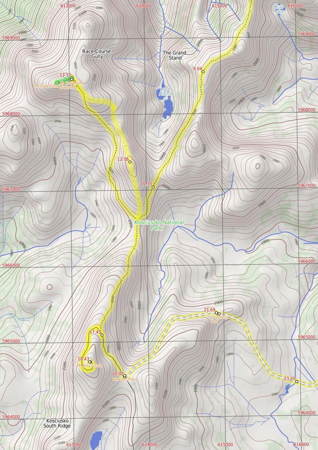
3 Are you ready to have fun? Please ensure you and your group are well prepared and equipped for all possible hazards and delays. Check park closures, weather information and Fire Danger Rating before setting out. Optional side trips and alternate routes noted are not included in this walks overall grade, length or time estimate. Please allow extra time for resting and exploring areas of interest. The authors, staff and owners of wildwalks take care in preparing this information but will not accept responsibility for any inconvenience, loss or injury you may experience. Please take care, have fun - Happy Walking. Experainced walkers only: This walk passes through very remote areas and sections have no visible track. At least one person in your group should have training and experience in off track walking and navigation. Even with these notes and a GPS these extra skills and equipment are required. Getting there Traveling by car is the only practical way to get to End of Kosciuszko Road (gps: , ). Car: A park entry fee is required for driving into the park. This is a circuit, so you will finish back at the start. Find up to date and more information inlcuding; travel directions, weather, park closures and walker feedback at 0 Covered in snow part of the year This walk leads through an extreme alpine environment and all walkers must be well prepared. During summer, be prepared for both very hot and cold weather, high winds, rain, snow, extreme UV levels and some sections of snow or ice on the ground. Before starting this walk, check advice with Snowy Region Visitor Information Centre (02) , the weather forecast and the snow conditions then change your plans as needed. These notes, grades and walking times have been written for use in the summer months only. Between May and the end of October, this walk is likely to be covered in snow/ice, visitors should carry and be prepared to use snowshoes or cross country skis. When there is a chance of significant snow on the ground, visitors will need particularly strong navigation and snowcraft skills tracks and signage may not be visible. For most visitors, it is best to consider this walk closed during the colder months. Between the long weekend in June and October, the road between Perisher Village and Charlotte Pass is closed by the RTA. It is possible to organise oversnow transport. 0 End of Kosciuszko Road (790 m 18 mins) From Charlotte Pass (at the turning circle at the end of Kosciuszko Rd), this walk follows the 'Main Range Track' - 'Blue Lake Lookout' sign downhill along the wide paved path. The walk winds down past the stone path (on your right) and continues beside the 'Glaciers shaped this ancient landscape' information sign. The path continues down through lightly scattered snow gums to the bottom of the valley, approximately 650m further. Just past the 'From the mountains to the sea' information sign, this walk crosses the Snowy River using the stepping stones and comes to a strip of land between the two creeks. (Crossing the river is dangerous and is not advisable when the water is flowing over the stepping stones) Snowy River crossing At the lowest point of the the Main Range circuit track is the confluence (meeting) of the Snowy River and Club Lake Creek. The walking track uses stones in the river to try to get across with dry feet. Since the track crosses just above the confluence there is an 'island' halfway across. These creeks may become impassable after rain and snow melt. This is lovely place to rest and enjoy the water and valley Snowy River crossing (3.2 km 1 hr 7 mins) Veer right: From between the two creeks, this walk heads north along the wide track to cross Club Lake Creek using the stepping stones. (The creek may not be safe to cross when water covers the stepping stones). The walk then follows the wide, paved track fairly steeply up the hill. After a short time, the track becomes gravel and continues up the hill for about 400m further before passing a 'Mountains of Soil' information sign, where the track soon becomes less steep. After about 1.5km, the track passes a 'Created by glaciers' information sign and reveals some views down to Hedley Tarn (on your right). The track continues up the hill and between the granite boulders to then head down the other side of the ridge. The walk leads down to rock-hop across Carruthers Creek, then follows the wide, paved path up the hill, passing the 'Remnants of an ancient sea' information sign and coming to a paved area, with a view to Blue Lake and some information signs marking a three-way intersection Int of Main Range and Blue Lake Lookout tracks (640 m 14 mins) Turn right: From the paved area, this walk follows the dirt track next to the stone seat, heading east towards Blue Lake. The rocky track winds down and around the northern side of the ridge to a platform with an information sign and a fantastic view of Blue Lake Optional sidetrip to Hedley Tarn (1.4 km 29 mins) Continue straight: From the lookout platform, this walk heads east down the rocky bush track to the bottom of the valley at the eastern end of the lake, and into the shallow gully, where the walk comes to the intersection of the Little Twynam track a short while later. Veer right: From the south eastern tip of the lake, this walk follows the Blue Lake creek into the shallow gully, where it comes to the intersection of the Little Twynam route about 150m downstream. Continue straight: From the intersection, this walk follows the bush track heading south-east, down-stream alongside the creek flowing out of Blue Lake to Hedley Tarn. The walk heads through to the southern end of the shallow gully and around the western side of Hedley Tarn, coming to the southern side. At the end of this side trip, retrace your steps back to the main walk then Continue straight Hedley Tarn Hedley Tarn is a beautiful glacial lake just south of Blue Lake, from which you can see right across the valley to the end of Kosciuszko Road at Charlotte Pass and is well worth the trip down from Blue Lake Blue Lake lookout (2.4 km 49 mins) Turn around: From the platform, the track heads west, uphill away from Blue Lake. The rocky track climbs up around the side of the hill, coming to a paved area with an information sign, stone seat and an intersection with the Main Range track. Veer right: From the intersection, this walk heads west, uphill away from Blue Lake. The walk initially heads along a short section of paved path before continuing along the wide gravel track. The track winds gently uphill for a while, keeping the wide valley to your left. The walk comes to a saddle and a three-way intersection, marked with a 'Main Range Track' signpost. Continue straight: From the intersection, this walk follows the 'Main Range Track' sign across the saddle then uphill along the clear track. The track winds up along the ridge and in time comes to a rocky clearing on the eastern side of Carruthers Peak (where a short detour will reveal views down to Club Lake). Here the walk bends right and follows the clear track as it winds up the hill to the views at the top of Carruthers Peak Carruthers Peak Carruthers Peak is a prominent mountain that is found along the Main Range track, from which you can see great views down over Club Lake and out across the valley to Charlotte Pass. Carruthers Peak was named after the NSW Minister for Lands and Premier, Joseph Carruthers. This name was given in 1991 by Richard Helms, who had previously named it Crummer Carruthers Peak (2 km 41 mins) Continue straight: From the top of Carruthers Peak, this walk follows the clear track west as it winds down the ridge. After about 50m, the track passes an 'I30' survey marker (more good views) where the track bends left and follows the stone path and steps down the hill. At the end of the stone path, the track bends left and heads down the hill, over a few lengths of metal grate and comes to a saddle with good views down to Club Lake (on your left). The walk then continues across the saddle, following the clear track to soon pass the 'Rarest Alpine Plant Community' information sign. Heading around the side of the hill (keeping the valley to your right), the walk then comes to another rocky saddle. About 320m beyond this saddle, this track leads to a very faint intersection where the ridge (that leads to the northern end of Albina Lake) on the right meets the main track Int of northern Lake Albina and Main Range tracks (1.7 km 37 mins) Continue straight: From the intersection, the walk follows the gravel Main Range track south, keeping the valley and Albina Lake to your right. The track heads downhill and then winds around beside a rocky saddle (a short side trip to the left over the small rise reveals some views into the valley). This walk continues along the clear track as it traverses fairly gently around the side of the very steep hill. In a few places, the track has been cut into the rock and provides great views down into the Albina Lake take care not to slip. The walk continues to another large saddle and just as the track starts to dip down past the saddle, the track comes to a faint intersection with an old management trail (leading to Lake Albina, on your right) Int of southern Lake Albina and Main Range tracks (520 m 11 mins) Continue straight: From the intersection, the walk follows the rock-paved Main Range track south. The track steadily winds around the side of the hill (keeping the large valley to your left). After heading between a rocky outcrop, the track becomes gravel and starts to head over the ridge before gently winding down the hill. Just before flattening out on the large saddle, the track comes to a faint intersection (with the Muellers Peak and Mt Townsend tracks on your right) marked with a rock cairn (on your right) Int of Main Range and Muellers Peak track (790 m 23 mins) Turn sharp right: From the intersection, the walk leaves the main path and heads north, off track, following the top of the ridge line. The walk climbs moderately steeply up the grassy hill. Near the top the walk comes to a rocky outcrop and the top of Muellers peak Muellers Peak (1.5 km 36 mins) Continue straight: From Muellers peak, this walk heads north, down the rocky ridge. The walk continues along the ridgeline working a way around the many boulders then around another smaller peak to come to a saddle and minor track intersection (with a pad that leads down to Lake Albina). Veer left: From the saddle, this walk heads north-west up the ridge line, keeping Lake Albina on your right (as it soon goes out of view) to climb up the hill. After a short time the walk finds a well worm foot pad which leads up between a few rocky outcrops to the large flat saddle between Mt Townsend and Alice Rawson Peak Mt Townsend plateau This bush campsite is in the saddle between Mt Townsend and Alice Rawson Peak. The large, reasonably flat grassy area with a scattering of boulders has no facilities or water supply. Camping is not permitted in areas that drain into the glacial lakes, so only camp and toilet on the north side of the saddle (this limits the amount of nutrients ending up in Lake Albina). There is some shelter from south-westerly winds, but the campsite is exposed to the
4 elements. An alternate campsite at Wilkensons Creek to the south may provide more shelter Optional sidetrip to Mt Townsend peak (210 m 7 mins) Turn left: From the saddle/plateau, this walk heads west, following the well worn foot pad towards the top of Mt Townsend. The pad leads around to the north eastern side of the peak, over a few boulders to find remains of an old building and a tall rocky outcrop. Here the walk scrambles up the rocks to find a concrete pillar and great views at the peak of Mt Townsend. At the end of this side trip, retrace your steps back to the main walk then Turn right Mt Townsend Mt Townsend is the second highest peak on the mainland of Australia and arguably the more impressive out of it and Kosciuszko. This point of view started the tradition of walkers climbing to the peak, putting a rock they'd find at the bottom in their pack and adding it to the top, in an attempt to make it the highest peak instead of Kosciuszko. A little known fact is that Mt Townsend was once called Mt Kosciuszko when it was originally thought that it was the highest peak, but when various measurements showed that the now named Kosciuszko was slightly higher, the NSW Lands department decided it would be easier to swap the names around instead of re-educating the public End of day 1 This is the planned overnight stay for the end of day 1, happy camping.

5 Pass Townsend plateau (2.3 km 56 mins) Turn around: From the saddle/plateau between Mt Townsend and Alice Rawson Peak, this walk heads south-east following the well worn foot-pad. The pad soon crosses a small creek and leads down the hill, tending right along the side of the ridge. The pad leads just below the saddle north of Muellers Peak, then continues to head fairly gently downhill around the side of Muellers Peak. Keeping Wilkinsons Creek valley below to your right, this walk heads around the side of the hill, crossing a few gullies before gently climbing up to the northern end of a large saddle where this walk comes to the gravel Main Range Track Int of Main Range and Muellers Peak track (1.6 km 42 mins) Veer right: From the intersection, this walk heads south along the main track to the low point in the saddle (where there is a faint intersection with a pad leading down to Wilkinsons Creek on your right). Continue straight: From the intersection, this walk heads south along the clear track, climbing up out of the saddle and along the side of the hill, keeping the valley to your left. The walk heads up many stone steps for about 600m, then flattens out for a little while before coming to a clear and signposted three-way intersection. (Here, the track on the right leads up to the summit of Mt Kosciuszko.) Int of Main Range track and Kosciuszko path (970 m 23 mins) Turn sharp right: From the intersection, this walk follows the 'Mt Kosciuszko' sign uphill along the upper track. This track winds steadily up and around the peak of the mountain, passing a stone-paved section of track, and also a metal grate before climbing a few steps to the cairn at the peak of Mt Kosciuszko Mt Kosciuszko Mt Kosciuszko is the highest peak on the Australian continent, at 2228m above sea level. It was named by the Polish explorer Count Paul Edmund Strzelecki and named in honour of the Polish national hero General Tadeusz Ko?ciuszko. Now a popular tourist attraction, thousands of people walk up to the summit each year. On a clear day, the 360-degree views from the summit across the roof of Australia are fantastic. There are higher mountains elsewhere on Australian territory. 'The highest mountains in Australian Antarctic Territory are Mt McClintock (3490 meters) and Mt Menzies (3355 meters).' Mt Kosciuszko (1.6 km 39 mins) Turn around: From the cairn at the peak of Mt Kosciuszko, this walk heads down the steps and past the information sign. The walk heads gently downhill along the gravel track then over a metal grate and a stone path, where the gravel path then leads the rest of the way around the side of the peak to come to the signposted intersection with the 'Main Range Track'. Veer right: From the intersection, this walk follows the gravel track towards 'Rawson Pass' gently downhill, keeping the main valley to your left. The track almost immediately passes an 'Alpine Walks' information sign and map as it continues south. After about 500m, the track becomes a stone path that leads a little further to the clearly signposted three-way intersection at 'Rawson Pass' Rawson Pass Rawson Pass is where the old Kosciuszko Road, from Charlotte Pass, meets the metal walkway from Thredbo. It is home to highest public toilet in Australia, this recently-added facility is perfectly positioned for those taking the walk up to the top of Kosciuszko. Rawson Pass is well signposted and 500m south east of Mt Kosciuszko (by straight line). There is also a place for to park mountain bikes for those cycling along the old road from Charlotte Rawson Pass (1.6 km 31 mins) Veer left: From the intersection at Rawson Pass, this walk follows the 'Seamans Hut' sign along the stone path. The walk soon passes the bicycle parking area then Australia's highest toilet block (on your right). The walk then continues along the management trail as it winds down along the side of the hill to a gap and the clearly signposted 'Seamans Hut' on your left Seamans Hut This hut was erected in 1929, after a young skier named Laurie Seaman perished in a blizzard when he was separated from his group. The hut was built using money donated by Seaman's parents, for the use of those who might need emergency shelter in the mountains. It was renovated in 1938 due to fire. Seamans Hut is a 7m x3m granite stone building with a wood stove, although there is little wood in the area. More info Seamans Hut (1.5 km 27 mins) Continue straight: From 'Seamans Hut', this walk follows the management trail as it winds down the hill. After about 450m, the trail passes a flat clearing with views (on your left) where the trail bends right to head down to the valley. After a little while, the trail crosses the concrete bridge over the signposted 'Snowy River' Snowy River bridge (4.5 km 1 hr 27 mins) Continue straight: From the bridge, this walk follows the management trail east, passing the 'Snowy River' sign. The trail soon bends left, coming to the un-signposted concrete Merritts Creek bridge. Continue straight: From the bridge, this walk heads uphill along the management trail, keeping the main line of snow poles to your left. The old road soon leads past a 'CP 4' sign (on your left), over the ridge line and down the other side. The trail gently winds down along the side of the hill, enjoying views of the Snowy River and valley to your left. The old road passes a few creeks and more 'CP' signs along the way. A little while after the 'CP 1' sign, the management trail enters a nice grove of snow gum trees then heads up a small rise to find the turning circle at the end of Kosciuszko Rd at Charlotte Pass (with the toilet block to your right).
6
7
8
9 Summary navigation sheet for the Main Range Track - Loop from Charlotte Pass camping near Mt Townsend km From 0.00 End of Kosciuszko Road , (GR Perisher Valley, ) Snowy River crossing , (GR Perisher Valley, ) Int of Main Range and Blue Lake Lookout tracks , (GR Perisher Valley, ) Blue Lake lookout , (GR Perisher Valley, ) m 18 mins 3.2 km 1 hr 7 mins 640 m 14 mins 1.4 km 29 mins Blue Lake lookout , (GR Perisher Valley, ) Carruthers Peak , (GR Perisher Valley, ) Int of northern Lake Albina and Main Range tracks , (GR Perisher Valley, ) Int of southern Lake Albina and Main Range tracks , (GR Perisher Valley, ) Int of Main Range and Muellers Peak track , (GR Perisher Valley, ) Muellers Peak , (GR Perisher Valley, ) Townsend plateau , (GR Perisher Valley, ) End of day , (GR Perisher Valley, ) Townsend plateau , (GR Perisher Valley, ) Int of Main Range and Muellers Peak track , (GR Perisher Valley, ) Int of Main Range track and Kosciuszko path , (GR Perisher Valley, ) Mt Kosciuszko , (GR Perisher Valley, ) Rawson Pass , (GR Perisher Valley, ) Seamans Hut , (GR Perisher Valley, ) Snowy River bridge , (GR Perisher Valley, ) km 49 mins 2 km 41 mins 1.7 km 37 mins 520 m 11 mins 790 m 23 mins 1.5 km 36 mins 210 m 7 mins 0m Powered by TCPDF ( Up/Dwn Length Initial directions (Use full tracknotes and maps for more detail) 2.3 km 56 mins 1.6 km 42 mins 970 m 23 mins 1.6 km 39 mins 1.6 km 31 mins 1.5 km 27 mins 4.5 km 1 hr 27 mins From Charlotte Pass (at the turning circle at the end of Kosciuszko Rd), this walk follows the 'Main Range Track' - 'Blue Lake Lookout' sign downhill along the wide paved path. Veer right: From between the two creeks, this walk heads north along the wide track to cross Club Lake Creek using the stepping stones. Turn right: From the paved area, this walk follows the dirt track next to the stone seat, heading east towards Blue Lake. Optional sidetrip to Hedley Tarn. Continue straight: From the lookout platform, this walk heads east down the rocky bush track to the bottom of the valley at the eastern end of the lake, and into the shallow gully, where the walk comes to the inters... Turn around: From the platform, the track heads west, uphill away from Blue Lake. Continue straight: From the top of Carruthers Peak, this walk follows the clear track west as it winds down the ridge. Continue straight: From the intersection, the walk follows the gravel Main Range track south, keeping the valley and Albina Lake to your right. Continue straight: From the intersection, the walk follows the rock-paved Main Range track south. Turn sharp right: From the intersection, the walk leaves the main path and heads north, off track, following the top of the ridge line. Continue straight: From Muellers peak, this walk heads north, down the rocky ridge. Optional sidetrip to Mt Townsend peak. Turn left: From the saddle/plateau, this walk heads west, following the well worn foot pad towards the top of Mt Townsend. This is the planned overnight stay for the end of day 1, happy camping. Turn around: From the saddle/plateau between Mt Townsend and Alice Rawson Peak, this walk heads southeast following the well worn foot-pad. Veer right: From the intersection, this walk heads south along the main track to the low point in the saddle (where there is a faint intersection with a pad leading down to Wilkinsons Creek on your right). Turn sharp right: From the intersection, this walk follows the 'Mt Kosciuszko' sign uphill along the upper track. Turn around: From the cairn at the peak of Mt Kosciuszko, this walk heads down the steps and past the information sign. Veer left: From the intersection at Rawson Pass, this walk follows the 'Seamans Hut' sign along the stone path. Continue straight: From 'Seamans Hut', this walk follows the management trail as it winds down the hill. Continue straight: From the bridge, this walk follows the management trail east, passing the 'Snowy River' sign.
Main Range Walk - Charlotte Pass to Mount Kosciuszko
 Main Range Walk - Charlotte Pass to Mount Kosciuszko 9 hrs Hard track 21.9 km Circuit 4 920m This full day walk explores some of the greatest alpine country on offer in NSW. The walk grants views of Blue,
Guthega to Mt Twynam. 2183m. 1583m. 6 hrs 45 mins 14.8 km Return. Experienced only. 913m
 Guthega to Mt Twynam 6 hrs 45 mins 14.8 km Return Experienced only 5 913m This walk starts from Guthega and makes its way along the Snowy River to the Illawong Lodge, via the Blue Cow Creek flying fox.
Main Range Circuit from Guthega
 Main Range Circuit from Guthega 4 Days Experienced only 45 km Circuit 5 2317m This four day walk explores the Kosciuszko National Park, covering many of the key features of the park between Guthega and
Merritts Traverse. 1928m
 Merritts Traverse 3 hrs Hard track 5.8 km Circuit 4 167m This walk starts with a scenic journey to the top of the hill on the chairlift. Starting along Merritts Nature walk, this walk soon detours down
Guthega to Thredbo camping overnight at Wilkensons Creek
 Guthega to Thredbo camping overnight at Wilkensons Creek 2 Days Experienced only 25.8 km One way 5 1364m This great overnight walk explores the Kosciusko National Park between Guthega and Thredbo, visiting
Victoria Falls Lookout to Blue Gum Forest
 Victoria Falls Lookout to Blue Gum Forest 8 hrs Experienced only 13.8 km One way 5 112m This long day-walk follows a remote track down from Victoria Falls lookout, passing the waterfall, and into the Grose
Erskine Creek via Pisgah Rock and Jack Evans
 Erskine Creek via Pisgah Rock and Jack Evans 4 hrs 30 mins 7.1 km Circuit Very experienced only 6 421m This walk visits some great lookouts and explores the lower section of Erskine Creek. Most of the
Congewai Track Head (East) to Watagan Headquarters
 to Watagan Headquarters") Congewai Track Head (East) to Watagan Headquarters 7 hrs Hard track 17.2 km One way 4 973m This full day walk starts from the Congewai valley trackhead (east) and follows the Great North Walk up into the
Congewai Track Head (East) to Watagan Headquarters 7 hrs Hard track 17.2 km One way 4 973m This full day walk starts from the Congewai valley trackhead (east) and follows the Great North Walk up into the
Nature Track. 900m. 789m. 2 hrs 3.1 km Circuit. Hard track 238m. Blue Mountains National Park
 Nature Track 2 hrs 3.1 km Circuit Hard track 238m Largely following the ridges around the top edge of Wentworth Falls, this track is incredibly beautiful. After taking in the great views at Edinburgh Castle
Staples Lookout to Mt Wondabyne loop
 Staples Lookout to Mt Wondabyne loop 4 hrs 3 mins 1.8 km Circuit Hard track 337m This walk starts and finishes at Staples Lookout, on Woy Woy Rd. The walk follows sections of the Great North Walk around
Leura Cascades to Gordon Falls Reserve
 Leura Cascades to Gordon Falls Reserve 1 hr 15 mins 1.8 km One way Moderate track 200m From Leura Park to Gordon Falls Park, this diverse walk offers fantastic views of the Jamison Valley, as well as two
Abbotts Falls Walking Track
 Abbotts Falls Walking Track 3 hrs 7.3 km Circuit Hard track 329m This circuit takes you through both dry and moist forest, using a combination of walking trails and wider tracks. The side trip to the dammed
Mt Kuring-gai Track to Berowra station
 Mt Kuring-gai Track to Berowra station 4 hrs 15 mins 9.7 km One way Hard track 4 553m This walk explores three valleys, with great displays of wild flowers in spring, and some nice sandstone overhangs.
Girrakool to Wondabyne station
 Girrakool to Wondabyne station 4 hrs Hard track 9.5 km One way 4 438m This walk starts from the Girrakool picnic area and winds south, through the Brisbane Waters National Park. The walk crosses some long
Dadder Cave and Jack Evans track
 Dadder Cave and Jack Evans track 2 Days 10.3 km Circuit Very experienced only 535m This fairly short overnight walk is a great way to explore Erskine Creek. The walking along Erskine creek is mostly off
Berowra Waters to Cowan Station
 Berowra Waters to Cowan Station 3 hrs 30 mins 7.2 km One way Hard track 597m This is a hilly walk out of the beautiful Berowra Waters valley to Cowan Station. There are many wide views across Berowra Creek
Wentworth Pass. 893m. 535m. 4 hrs. Hard track 5.1 km Circuit. 692m
 Wentworth Pass 4 hrs Hard track 5.1 km Circuit 4 692m This walk offers a great way to explore the magical, upper section of the Valley of the Waters. The walk starts and finishes at Conservation Hut, which
National Pass. 893m. 665m. 3 hrs 30 mins 4.6 km Circuit. Hard track 773m. Blue Mountains National Park
 National Pass 3 hrs 3 mins 4.6 km Circuit Hard track 773m 4 This walk offers fantastic views of the Jamison Valley and the surrounding cliffs. Take time to explore the historic and very scenic ledge halfway
Scenic Railway to Ruined Castle
 Scenic Railway to Ruined Castle 7 hrs 30 mins 12.4 km Return Hard track 4 963m This is a very popular, full day walk, in the Katoomba Area, offering great views of the valley. The walk follows the edge
Girrakool to Wondabyne station via Pindar caves
 Girrakool to Wondabyne station via Pindar caves 7 hrs 30 mins 18.1 km One way Experienced only 5 741m This walk starts from the Girrakool picnic area and winds south, following Piles creek into the Brisbane
Victoria Falls and Grose Valley to Blackheath Station
 Victoria Falls and Grose Valley to Blackheath Station 3 Days Experienced only 22.5 km One way 5 158m This walk explores a fantastic section of the Grose Valley. Starting above Victoria Falls, the walk
Victoria Falls to Blackheath Station
 Victoria Falls to Blackheath Station 2 Days Experienced only 22.2 km One way 5 1561m This is a fantastic overnight walk with a sleep in Acacia Flats camping area. The Grose Valley, with its views of the
Berowra to Cowan via Berowra Waters
 Berowra to Cowan via Berowra Waters 6 hrs Hard track 12.9 km One way 4 884m With train station at each end this walk explores the ridges and valleys around Berowra Waters. There are plenty of excellent
Gibberagong Track. 169m
 Gibberagong Track 2 hrs 30 mins 6.5 km One way Hard track 4 180m Starting in suburban Wahroonga, this wellmaintained track follows Cockle Creek down to Bobbin Head in the Ku-ring-gai Chase National Park.
Jerusalem Bay Track (Cowan to Brooklyn)
") Jerusalem Bay Track (Cowan to Brooklyn) 5 hrs 30 mins 13.4 km One way Hard track 4 654m This Cowan to Brooklyn Station walk is a popular section of the Great North Walk, with scenery ranging from foreshore
Jerusalem Bay Track (Cowan to Brooklyn) 5 hrs 30 mins 13.4 km One way Hard track 4 654m This Cowan to Brooklyn Station walk is a popular section of the Great North Walk, with scenery ranging from foreshore
Crosslands to Berowra Waters return
 Crosslands to Berowra Waters return 6 hrs Hard track 13.7 km Return 4 1005m This return walk starts from the Crosslands Reserve and follows the Great North Walk along Berowra creek. The walk includes some
Crosslands to Cowan. 220m
 Crosslands to Cowan 7 hrs 30 mins 14 km One way Hard track 4 1103m This section of the Great North Walk starts from the Crosslands camping area and winds north alongside Berowra creek, passing through
Somersby to Yarramalong via Stringy Bark Point
 Somersby to Yarramalong via Stringy Bark Point 2 Days Hard track 26.7 km One way 4 1201m This section of the Great North Walk starts form the Somersby General Store and follows the Great North Walk north
Patonga to Staples Lookout
 Patonga to Staples Lookout 6 hrs 3 mins 17 km One way Hard track 4 72m This great walk explores much of the main ridge ridge running through Brisbane Water National Park. The walk visits a number of great
Lady Carrington Drive
 Lady Carrington Drive 3 hrs 45 mins 9.7 km One way Moderate track 3 266m This walk follows the historic Lady Carrington Drive alongside the Hacking River. The old road is closed to traffic and provides
Blackheath to Blue Gum loop
 Blackheath to Blue Gum loop 2 Days Hard track 24.1 km Circuit 4 1335m This walk is great for fit people getting into overnight walking, with its fantastic scenery and nostalgia as a classic overnighter.
Hornsby station to Crosslands
 Hornsby station to Crosslands 6 hrs 45 mins 16.1 km One way Hard track 4 938m This section of the Great North Walk starts from Hornsby train station and winds down along the Blue Gum Walk into Fishponds.
Katoomba to Wentworth Falls via the Jamison Valley
 Katoomba to Wentworth Falls via the Jamison Valley 2 Days Experienced only 29.2 km One way 5 2135m This is the two day version of this popular and challenging walk. This walk passes popular sights including
Patonga to Wondabyne station via Mt Wondabyne
 Patonga to Wondabyne station via Mt Wondabyne 7 hrs 3 mins 19.5 km One way Hard track 4 861m This walk explores some grand views, pleasant cascades, varied bushland and remote areas of Brisbane Waters
Leura to Katoomba via Dardanelles Pass
 Leura to Katoomba via Dardanelles Pass 4 hrs 6.6 km One way Hard track 697m With approximately equal parts cliff-walk and forest track, this track truly shows what the cliff edges of the Jamison Valley
Somersby to the Basin Campsite
 Somersby to the Basin Campsite 3 Days Hard track 47.4 km One way 4 2032m This three day walk starts at the Somersby General Store and follows the Great North Walk, heading north, into the the Jilliby State
The Prince Henry Cliff Walk
 The Prince Henry Cliff Walk 3 hrs 30 mins 6.8 km One way Moderate track 3 575m Going from Katoomba to Leura, this walk covers the top of the cliff line and most of the major lookouts. With brilliant vistas
Patonga to Wondabyne station via Pindar Caves overnight
 Patonga to Wondabyne station via Pindar Caves overnight 2 Days Experienced only 28.1 km One way 5 1164m This overnight hike starts from Patonga beach and winds along a section of the Great North Walk,
Wondabyne station to Somersby Store
 Wondabyne station to Somersby Store 10 hrs Hard track 26.2 km One way 4 1164m This walk, following a section of the Great North Walk, starts from the Wondabyne train station and winds north, into the Brisbane
Berowra to Hornsby. 9 hrs 18 mins 22.6 km One way. Hard track. 1423m
 Berowra to Hornsby 9 hrs 18 mins 22.6 km One way Hard track 4 1423m One of the longer day walks in Berowra Valley National Park, this walk mostly follows Berowra Creek along the Great North Walk. Excellent
Out and about at Geehi
 Geehi Geehi Flats is a large area of flat floodplain on the banks of the Swampy Plains River. Located within Kosciuszko National Park, it is home to a popular campsite in summer for people wanting to enjoy
Victoria Falls and Grose Valley to Blackheath Station
 This walk explores a fantastic section of the Grose Valley. Starting above Victoria Falls, the walk explores the cascades before dropping into the valley for the first nights rest at Burra Korain campsite.
Cowan to Wondabyne station via Patonga rest area
 Cowan to Wondabyne station via Patonga rest area 2 Days Hard track 33.4 km One way 4 1523m This section of the Great North Walk starts from Cowan train station and wanders past the majestic Jerusalem Bay
Crosslands to Brooklyn
 Crosslands to Brooklyn 2 Days Hard track 27.4 km One way 4 1757m From the Crosslands Reserve, this walk heads along the Great North Walk via Berowra Waters, Cowan, Jerusalem Bay and onto Brooklyn. This
Western Commission Track to Dubbo Gully
 This two day walk follows a series of historic roads along clear and wide management trails. This walk explores the great views from Western Commission Track, the sandstone handicraft on the Old Great
Gordon to Hornsby (overnight at Scout camp)
") Gordon to Hornsby (overnight at Scout camp) 2 Days Hard track 25.8 km One way 4 125m This overnight walk starts from Gordon train station and winds through bush filled valleys to Hornsby station. From
Gordon to Hornsby (overnight at Scout camp) 2 Days Hard track 25.8 km One way 4 125m This overnight walk starts from Gordon train station and winds through bush filled valleys to Hornsby station. From
GOLDEN EARS PROVINCIAL PARK
 GOLDEN EARS PROVINCIAL PARK Trail Information as of October 10 th 2015 Do not underestimate the mountainous wilderness of Golden Ears Provincial Park. The combination of rugged terrain and rapidly changing
Trail Phasing Plan. Note: Trails in the Clear Creek Canyon area (Segments will be finalized in the future to minimize wildlife impacts
 Note: Trails in the Clear Creek Canyon area (Segments 2 5 and a future JCOS connection) will be finalized in the future to minimize wildlife impacts Trail Phasing Plan P Parking 3 Easy Trail Intermediate
beach. Make the ford and follow the trail out to the junction with Red Creek Tr in an open grassy area.
 Description: This is a moderate to slightly strenuous 22.8 mile backpack (add 2.6 miles if you do the packless out and back to the Lion s Head) that will have you exploring nearly every thing that is The
Thornleigh to Cowan. 2 Days. Hard track 35.9 km One way. 2337m
 Thornleigh to Cowan 2 Days Hard track 35.9 km One way 4 2337m Following the Great North Walk and Berowra Creek through Berowra Valley Regional Park, this walk cuts straight through the length of the Park.
Route #2) Mt. Massive - Southwest Slopes
 Mt. Massive - Southwest Slopes") Route #2) Mt. Massive - Southwest Slopes Difficulty: Class 2 Ski: Advanced, D6 / R2 / III Exposure: Summit Elevation: Trailhead Elevation: Elevation Gain: Round-trip Length: Trailhead: County Sheriff:
Route #2) Mt. Massive - Southwest Slopes Difficulty: Class 2 Ski: Advanced, D6 / R2 / III Exposure: Summit Elevation: Trailhead Elevation: Elevation Gain: Round-trip Length: Trailhead: County Sheriff:
ID: 283 Distance: 6.2 miles Height gain: 500 Metres Map: Explore OL 19 Contributor David and Chris Stewart
 Walkingworld Wild Boar Fell ID: 283 Distance: 6.2 miles Height gain: 500 Metres Map: Explore OL 19 Contributor David and Chris Stewart Features Birds, Great Views, Hills or Fells Description: Wild Boar
Overnight Guided Walks
 Overnight Guided Walks Day One Climb through a forest of snow gums from Dead Horse Gap, before following the ridge line toward Mount Kosciuszko. Head for our base camp and enjoy the hospitality of our
Self-Guided Walk Langdale Pikes. Start & Finish: NT car park (free to members) at Sticklebarn - on the right just beyond the New Dungeon Ghyll hotel.
 at Sticklebarn - on the right just beyond the New Dungeon Ghyll hotel.") Self-Guided Walk Langdale Pikes Key Information These mountains form a collection of spires and cliffs on the north side of Langdale. This walk visits four of the main tops Pavey Ark, Harrison Stickle,
Self-Guided Walk Langdale Pikes Key Information These mountains form a collection of spires and cliffs on the north side of Langdale. This walk visits four of the main tops Pavey Ark, Harrison Stickle,
Route Combo) Mt. Bierstadt - Bierstadt, Sawtooth, Evans
 Mt. Bierstadt - Bierstadt, Sawtooth, Evans") Climbing 14ers can be very dangerous, please read the Mountaineering Safety Page and make sure you have a map+compass and can use them effectively, without the help of electronic devices. Route Combo)
Climbing 14ers can be very dangerous, please read the Mountaineering Safety Page and make sure you have a map+compass and can use them effectively, without the help of electronic devices. Route Combo)
Leaden Boot Challenge 2016 ROUTE INSTRUCTIONS
 Leaden Boot Challenge 2016 ROUTE INSTRUCTIONS Section 1 Alstonefield to Ilam (CP2) From the village hall car park turn R then L and pass through the village keeping to the R to enter Church Street. Pass
COSTA BLANCA MOUNTAIN WALKERS - WALK DESCRIPTION. Visit for more walks descriptions in Spain
 COSTA BLANCA MOUNTAIN WALKERS - WALK DESCRIPTION Visit www.walksinspain.org for more walks descriptions in Spain Walk description originally prepared by:- Ralph Phipps Last Updated 25th Sep 2015 Title
Podcast 31 - The Australian Alps - A Trip to Thredbo
 Podcast 31 - The Australian Alps - A Trip to Thredbo by Rob McCormack - Friday, January 03, 2014 http://slowenglish.info/?p=918 Learn English while learning about daily life in Australia, with Rob McCormack
IRON BARK and COLENSO HUTS 260 Series Map: 1:50, U21 NZ Grid GPS: Geodetic Datum 1949
 IRON BARK and COLENSO HUTS 260 Series Map: 1:50,000 260-U21 NZ Grid GPS: Geodetic Datum 1949 Topo50 Map: BK36 Taoroa Junction GPS: on WGS84 How to get to START: Exit Taupo on SH1 down the lake to Turangi
TUPPER DESIGNATED ACCESS ROUTE
 TUPPER DESIGNATED ACCESS ROUTE 1 FOR ACCESS/EGRESS TO CONNAUGHT, LOOKOUT, STONE ARCH, PORTAL PATHS AND TUPPER TRAVERSE EGRESS Length: 2.6km Vertical Gain: +162m / -83m (Values are for access. For egress,
Leaden Boot Challenge ROUTE INSTRUCTIONS
 Leaden Boot Challenge ROUTE INSTRUCTIONS Section 1 Alstonefield to Ilam From the village hall car park turn R then L and pass through the village keeping to the R to enter Church Street. Pass the Church
The Mendip Way. Route Directions and Maps Uphill to Wells
 The Mendip Way Route Directions and Maps Uphill to Wells Website: www.mendiphillsaonb.org.uk Email: mendip@mendiphillsaonb.org.uk Facebook & Twitter: @MendipHillsAONB Phone: 01761462338 1 Uphill to Loxton
playwinterpark.com Off The Beaten Path Hikes Hiking Recommendations for the Adventurous Hiker
 playwinterpark.com Off The Beaten Path Hikes Hiking Recommendations for the Adventurous Hiker Hike: Devil s Thumb (difficult) Length: 3.93 miles one-way Elevation: Trailhead 9609 Destination 12,236 Trailhead
GRINDLEFORD GALLOP 2018
 GRINDLEFORD GALLOP 2018 Route Information The Grindleford Gallop follows a fixed 21 mile route through the lanes and paths of Derbyshire. All competitors must follow this route. An OS map of the area with
PERUVIAN ANDES ADVENTURES. ARTESONRAJU CLIMB 6025m (19767 ft) Grade: D+ to TD/ Technical. Routes: The two routes to climb Artesonraju are;
 Grade: D+ to TD/ Technical. Routes: The two routes to climb Artesonraju are;") PERUVIAN ANDES ADVENTURES ARTESONRAJU CLIMB 6025m (19767 ft) Grade: D+ to TD/ Technical Routes: The two routes to climb Artesonraju are; *Via the Paron Valley South East Ridge 5 days (option for 6 with
PERUVIAN ANDES ADVENTURES ARTESONRAJU CLIMB 6025m (19767 ft) Grade: D+ to TD/ Technical Routes: The two routes to climb Artesonraju are; *Via the Paron Valley South East Ridge 5 days (option for 6 with
Below is an example of a well laid-out template of a route card used by the Sionnach Team which is a good format to begin with.
 Route Card A route card is used as a navigational aid to hill walkers by setting out a step by step plan for an intended hike. It is good practice to make out a route card before every hike you or your
Charnley Explorer June 24 - July 15, 2018 Bachsten Creek and the Charnley River. Second draft: 14 November 2017
 Charnley Explorer June 24 - July 15, 2018 Bachsten Creek and the Charnley River. Second draft: 14 November 2017 The best part of the original section one is now part of out Gibb Road Gorges trip. The dates
Slad over to Pitchcombe and back
 The walk climbs up from Slad over Wickridge Hill, descends to near Pitchcombe, then climbs back over Wickridge hill and round the back of Slad. Page 1 Start Point: SO 8718 0732 The Woolpack, Slad Length:
The Trails. Hwy. 40 Kananaskis Valley. Hwy. 1 Canmore, Bow Valley. Hwy. 40 Peter Lougheed Prov. Park. Hwy. 742 The Smith-Dorrien. Hwy.
 The Trails Hwy. 1 Canmore, Bow Valley 1 Grassi 8 2 Ha Ling Peak 13 3 Teahouse Ridge 17 4 Grotto Canyon 21 5 Raven s End 24 6 Bow Valley Provincial Park Loop 28 7 Heart Mountain Circuit 32 8 Wind Ridge
County Line trail - Miller Peak to Little Navaho
 County Line trail - Miller Peak to Little Navaho 7-17-2008 This hike features a portion of the County Line trail in the Teanaway that receives extremely little use despite offering a spectacular ridge-run
Waiau Pass Track. (Map 92, 91, 90, 89, 88, 87)
") Waiau Pass Track (Map 92, 91, 90, 89, 88, 87) Southern Start Northern End Distance Time Track Standard Boyle Village St Arnaud Village 115.5km 5-8 days Tramping track At 1870m, Waiau Pass is the most likely
Waiau Pass Track (Map 92, 91, 90, 89, 88, 87) Southern Start Northern End Distance Time Track Standard Boyle Village St Arnaud Village 115.5km 5-8 days Tramping track At 1870m, Waiau Pass is the most likely
Skiing and Snowshoes on Un-groomed Fernan Saddle Terrain
 Skiing and Snowshoes on Un-groomed Fernan Saddle Terrain Three ski or snowshoe routes are available from the Fernan Saddle Parking Lot which either do not cover routes ordinarily groomed for snow machine
Garibaldi Provincial Park Trail Conditions
 Garibaldi Provincial Park s August 2, 2018 Garibaldi Park is located in the coast mountain wilderness and the weather can be severe and unforgiving. Be well prepared, properly equipped and informed before
TREK THE ROCKIES ABOUT THE CHALLENGE TREK THE ROCKIES FOR HIGHLAND HOSPICE CANADA TREK DEMANDING
 TREK THE ROCKIES CANADA TREK DEMANDING ABOUT THE CHALLENGE The Canadian Rockies are justifiably world-famous for their magnificent scenery: the combination of impressive, jagged mountains, bright turquoise
Sponsored by. statestreet.com
 /STATESTREETISLANDWALK #ISLANDWALKJSY Sponsored by statestreet.com Important Information If you forget everything else PLEASE remember the following.» Remember to check OUT of every checkpoint» If you
Wicklow Mountains Path Survey
 Wicklow Mountains Path Survey Ballinacor Croaghanmoira Fananierin Start to Finish: T 11723 86602 to T 11175 89057 Altitude (lowest highest): 385m 664m Weather: Hot Access: Coolgarrow forest entrance Surveyed
A Circular Walk from Chapel Carn Brea
 A Circular Walk from Chapel Carn Brea 4.3 Miles A Walk Visiting Five Historic Ancient Sites This circular walk offers the possibility of several alternatives, depending on the walker s available time and
Wicklow Mountains Path Survey
 Wicklow Mountains Path Survey Glenmacnass Tonelagee Start to Finish: O 114 030 to O 085 016 Altitude (lowest highest): 370m 817m Weather: Sunny day, hot Access: Military Road, Glenmacnass Surveyed by:
Morning Star Peak Avalanche Accident
 Morning Star Peak Avalanche Accident Saturday, December 4, 2010 Date: 2010-12-13 Submitted by: Oyvind Henningsen Everett Mountain Rescue and Mark Moore NWAC Place: Morning Star Peak, north-central WA Cascades
1. Waterfall Gully Mt Lofty. 5 Of the Best Hikes in Adelaide
 Adelaide is a beautiful city, and one of the most incredible things about Adelaide is the quality of bushwalking available on the suburban fringe. It is surrounded by the Mt Lofty Ranges, and much of the
The Bridestone Rocks from Lydgate
 Print this page Back to results The Bridestone Rocks from Lydgate Ancient tracks and gritstone outcrops, with terrific views of the steepsided Cliviger Valley. Distance 5 miles (8km) Minimum time 2hrs
Hiking Las Vegas.com
 Hike: Mt. Wilson via First Creek Canyon route Trailhead: First Creek marked Distance: 10 miles up and back Elevation gain: 3,400 feet Elevation of Peak: 7,070 feet Time: 7 to 9 hours (up and back) Difficulty:
Trekking at Peuma Hue
 Trekking at Peuma Hue Peuma Hue is a paradise for those who love hiking and trekking. A large variety of trails cross pristine forest, ancient rocks and stunning waterfalls with beautiful views over the
Around and about Geraldine
 Around and about Geraldine A guide to recreational opportunities SOUTH CANTERBURY Track classifications Short walk Easy walking for up to an hour Track is well formed, with an even, welldrained surface.
Tiger Mountain State Forest:
 98 60 hikes within 60 miles: SEATTLE 20 Tiger Mountain State Forest: West Tiger Mountain Three Loop i KEY AT-A-GLANCE INFORMATION Length: 5.1 miles round-trip Configuration: Loop Difficulty: Moderate difficult
CIEC 9 PEAKS AWARD SUPPLEMENT POSSIBLE ROUTES FOR THE 9 PEAKS AWARD TRIP
 CIEC 9 PEAKS AWARD SUPPLEMENT POSSIBLE ROUTES FOR THE 9 PEAKS AWARD TRIP As you plan your trip, be aware of 3 regulations in this wilderness: 1. Camp only in designated campsites. 2. No campfires allowed.
PERUVIAN ANDES ADVENTURES. TOCLLARAJU CLIMB or ISHINCA + TOCLLARAJU CLIMBING. Tocllaraju 4 Days Ishinca + Tocllaraju 5 or 6 days
 PERUVIAN ANDES ADVENTURES TOCLLARAJU CLIMB or ISHINCA + TOCLLARAJU CLIMBING Tocllaraju 4 Days Ishinca + Tocllaraju 5 or 6 days PEAKS Tocllaraju: 6034m (19797 ft) Grade: D / Hard / Some steep & technical
CAMELBACK MOUNTAIN: CHOLLA TRAIL
 CITY OF PHOENIX :: Camelback Mountain: Cholla T rail 21 CAMELBACK MOUNTAIN: CHOLLA TRAIL IN BRIEF Camelback Mountain is the tallest point in the city of Phoenix. From the 2,704-foot summit of Camelback,
C E N T R A L C A T S K I L L S
 120 C E N T R A L C A T S K I L L S Central Catskills Once out of the southern parts of the Catskills, the Long Path enters the more well traveled and civilized regions. The trail joins the Devil s Path,
Mt. Elbert East Ridge
 Mt. Elbert East Ridge Difficulty: Class 1 Exposure: None Summit Elev.: 14,440 feet Trailhead Elev.: 10,400 feet Elevation Gain: 4,100 feet Roundtrip Length: 8.5 miles Trailhead: South Elbert (near Twin
Ystwyth and Rheidol Bridleway Routes. Route 2:Llanilar Circular
 Ystwyth and Rheidol Bridleway Routes Route 2:Llanilar Circular Route overview and terrain: A long circle using connecting ridges with fine views to link the Rheidol and Ystwyth river valleys. The route
Garibaldi Provincial Park Trail Conditions
 Garibaldi Provincial Park s November 20, 2018 Garibaldi Park is located in the coast mountain wilderness and the weather can be severe and unforgiving. Be well prepared, properly equipped and informed
South East Wales Hang Gliding and Paragliding Club Ltd
 Section Release/Amendment Summary Rev Date All Initial issue 1 12/12/2016 Created By: Reviewed By: Approved By: Martin Cray Committee Member Chris Jones Avon Committee Member Management Representative:
Hiking Las Vegas.com
 Hike: Juniper Peak up and back Trailhead: Oak Creek Canyon marked Distance: 5.5 miles round trip Elevation gain: 2,200 feet Elevation peak: 6,109 feet Time: 4 to 5 hours - Up and back Difficulty: 3 Danger
SYNOPSIS WEATHER AND SNOWPACK
 Peak 6996 Avalanche Fatality Incident Report Glacier National Park, MT Date of Avalanche: 31 March 2010 Date of Investigation: 2 April 2010 Investigation Team: Erich Peitzsch (USGS), Ted Steiner (Chugach
Little Grand Canyon near Pomona, Illinois
 Little Grand Canyon near Pomona, Illinois Below: View of the trail and the terrain created using the Map My Hike app Below: Summary of the hike created using the Map My Hike app Presented by: Jennifer
Walking Track Classification System Parks and Wildlife Service
 Appendix A Walking Track Classification Specifications Walking Track Classification System Parks and Wildlife Service This Walking Track Classification System is the outcome of a review of the track classifications
Difficult Run Stream Valley Park
 Difficult Run Stream Valley Park The more intense mountain bikers have known about for Difficult Run for some time. Equestrians have known it longer. Eight miles of unpaved trail, the Rails to River Trail
Hindhead, Keffolds Copse and Gibbet Hill
 point your feet on a new path, Keffolds Copse and Gibbet Hill Distance: 6 km=4 miles Region: Surrey Author: Schwebefuss Refreshments: Punch Bowl Café moderate walking Date written: 14-apr-2015 Last update:
Camp Jack Wright PERMANENT ORIENTEERING COURSE (2004)
") Camp Jack Wright PERMANENT ORIENTEERING COURSE (2004) WHAT IS ORIENTEERING? The skill which enables a person to navigate with a map. In the competitive sport, the winner is the person who finishes in the
Camp Jack Wright PERMANENT ORIENTEERING COURSE (2004) WHAT IS ORIENTEERING? The skill which enables a person to navigate with a map. In the competitive sport, the winner is the person who finishes in the