COSTA BLANCA MOUNTAIN WALKERS - WALK DESCRIPTION. Visit for more walks descriptions in Spain
|
|
|
- Alexander Glenn
- 5 years ago
- Views:
Transcription
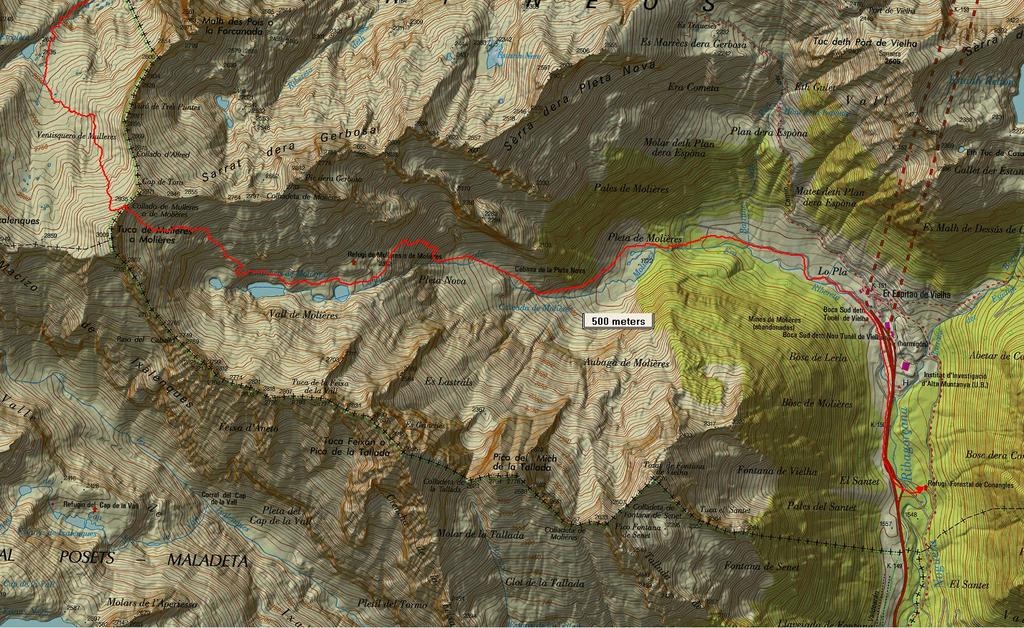
1 COSTA BLANCA MOUNTAIN WALKERS - WALK DESCRIPTION Visit for more walks descriptions in Spain Walk description originally prepared by:- Ralph Phipps Last Updated 25th Sep 2015 Title of Walk GR11 Day 24. Refugio Renclusa to Refugio Conangles via Tuc de Molieres Location of Start (include name of nearest village/town at start of description) Benasque Refugio Renclusa to the N of the village in a remote mountain location. Key Statistics for walk - Distance in km 18 Key Statistics for walk - Ascent in m 1150 Key Statistics for walk - Walking time and total completion time including any stops 6 8 Key Statistics for walk - Grade (using CBMW system) VS/B/Scr/X Grid reference of start point (if known) Lat: , Long: Directions to Start The N260 runs E-W along the central par of N Spain. From this find the A139 heading N to Benasque. Follow this road past Benasque for several kilometers and 2km before it ends take a concrete road dropping to the R and signed to Hotel Hospital de Benasque and La Besurta. Continue to the car park at La Besurta and walk from here following the signs to the Refuge about 1 hour. Short walk description A high level crossing of a Pyrenean ridge with a short passage of scrambling to descend and remote rocky mountain fastnesses. Full Walk Description Note:- At the time of writing (Sep 15) the GR11 route from Benasque to Vielha (Conangles) is challenged by the absence of accommodation. A new refuge -Cap de Llauset is under construction but until it is finished (Autumn 16?) the leg is too long for ordinary mortals and camping would be necessary. The alternative provided by this route and the previous leg is to cross a high and rugged pass from Renclusa via Barranco Escaleia and walk down to Conangles from Tuc de Molieres to the south side of the Vielha tunnel. The previous day's route up from Puente de San Chaime has nothing much to Elapsed Walking Time/Distance so far
2 COSTA BLANCA MOUNTAIN WALKERS - WALK DESCRIPTION commend it being a long walk along forest tracks and so transport to the Hotel de Hospital de Benasque is assumed as a starting point with a walk up to today's starting point the Refugio de Conangles! Exit the Refuge and turn L slightly uphill for 50 m or so to find a fingerpost with a sign pointing L to Collado Renclusa with R/W markers. Take this path to reach the Col. Walk down the other side soon looking into a large river valley and at the bottom turn R at a finger post working around the RH edge of the plateau. (May be wet after prolonged rain!) Near the top edge of this cross a stream L using a bridge and then another immediately after. 500m, 15min 1.6km, 36min 2.4km, 48min Make sure you are going to head up the correct valley. From here you must head just S of E across level ground but with a waterfall down rocks in the near distance. Near to these rocks you turn R joining a good path that has come up from La Besurta on the far bank of the stream and start to climb up in zig-zags. As the slope eases you are heading ESE and you continue up a rugged mountain valley to pass a mountain lake (sometimes dry) on your RHS. 4.3km, 1hr 23min Take care here to look out for the correct valley now. There is a sign on a boulder pointing to Molieres and this is what you need following cairns initially SE and later SSE to reach a second thin lake which you pass on the R. 5.1km, 1hr 38min After a more level stretch and yet another lake work more steeply up with some short patches of scrambling SE to reach a further lake in a craggy fastness and here turn R to head SE still steeply uphill and now across rock slabs as you continue ahead. 6.2km, 2hr 4min Above yet another lake (which you may not see) you turn SSE to head steadily up a scree and slab filled valley towards Tuc de Molieres. It is vitally important here to find the correct coll here because descent on the far side is quite tricky use the gps track! Eventually you reach a thin rocky ridge with rock impediments and spires jutting up in all directions. This is the Collado de Molieres at about 2940m with the summit of Tuc de Molieres just to your R at a little over 3000m 8.4km, 3hr 4min Look around for routes down. There are at least 3 and the route nearest to Cap de Tora (further away from your direction of travel) provides the easiest descent. Scramble down a little with care to find a zig-zag path descending across scree for a short while and then replaced by a cairned route across boulder fields to the E. The going remains difficult for some time as you search about looking for the best route down but in any event you are aiming for the valley floor. There is respite to the steepness as you pass the series of 4 pater-noster lakes and a small cabin comes in to view high above us on the LHS. Once clear of these our path wanders off to the NE aiming for apparently easier going. However once you reach a patch of difficult iron laden rock scree the path turns in zig-zags to avoid crossing this and to find a route down. 10.3km, 3hr 53min
3 COSTA BLANCA MOUNTAIN WALKERS - WALK DESCRIPTION Finally clear of the worst of the rocky going the path continues down to reach a short down scramble almost IN the Cascada de Molieres 12.4km, 4hr 42min and then at last the slope eases into grassier terrain. Continue down hill to reach a wooded and bouldery section which has many cairns but still requires careful navigation to find the best route and then walk down beside the series of waterfalls to emerge in a grassy plateau. 13.5km, 5hr 5min Here you pick up a track and follow this out towards the road and the end of the road tunnel from Vielha. There are choices once you reach a fork at a rising section of track. 14.9km, 5hr 26min Go L and cross above the tunnel to the old closed Refugio at Espitau de Vielha and then follow the path S on the E side of the valley to reach the Refugio de Conangles OR, perhaps easier at the end of a long and demanding day...you can take the R fork to reach the tarmac road and follow this S to reach a large parking area on the LHS with a sign to the refuge just across the bridge. (gps troute does this!) Walk Recommendations or restrictions Experience of mountaineering and scrambling required.

4 Route followed is outlined in Red
5
6
COSTA BLANCA MOUNTAIN WALKERS - WALK DESCRIPTION. Visit for more walks descriptions in Spain
 Visit www.walksinspain.org for more walks descriptions in Spain Walk description originally prepared by:- Ralph Phipps Last Updated 15 th July 2016 Title of Walk Location of Start (include name of nearest
Self-Guided Walk Langdale Pikes. Start & Finish: NT car park (free to members) at Sticklebarn - on the right just beyond the New Dungeon Ghyll hotel.
 at Sticklebarn - on the right just beyond the New Dungeon Ghyll hotel.") Self-Guided Walk Langdale Pikes Key Information These mountains form a collection of spires and cliffs on the north side of Langdale. This walk visits four of the main tops Pavey Ark, Harrison Stickle,
Self-Guided Walk Langdale Pikes Key Information These mountains form a collection of spires and cliffs on the north side of Langdale. This walk visits four of the main tops Pavey Ark, Harrison Stickle,
ID: 283 Distance: 6.2 miles Height gain: 500 Metres Map: Explore OL 19 Contributor David and Chris Stewart
 Walkingworld Wild Boar Fell ID: 283 Distance: 6.2 miles Height gain: 500 Metres Map: Explore OL 19 Contributor David and Chris Stewart Features Birds, Great Views, Hills or Fells Description: Wild Boar
IRON BARK and COLENSO HUTS 260 Series Map: 1:50, U21 NZ Grid GPS: Geodetic Datum 1949
 IRON BARK and COLENSO HUTS 260 Series Map: 1:50,000 260-U21 NZ Grid GPS: Geodetic Datum 1949 Topo50 Map: BK36 Taoroa Junction GPS: on WGS84 How to get to START: Exit Taupo on SH1 down the lake to Turangi
Baggy Point, Croyde, North Devon
 Baggy Point, Croyde, North Devon A walk using the South West Coast Path that is likely to be suitable for people with impaired mobility or with a pushchair, wheelchair, or mobility scooter. The Coast Path
(WP19178masl) where the left branch is taken. Within 50min 300m are ascended. Start of the track shelter. Level grassy area
 where the left branch is taken. Within 50min 300m are ascended. Start of the track shelter. Level grassy area") SOUTHERN CROSSING 260-Series: Levin S25, S26 Carterton NZ Grid GPS: Geodetic datum1949 Topo50 Map: BP33 Featherstone NZTM GPS: NZTM on WGS 84 How to get to START: The motor camp in Levin makes a good overnight
SOUTHERN CROSSING 260-Series: Levin S25, S26 Carterton NZ Grid GPS: Geodetic datum1949 Topo50 Map: BP33 Featherstone NZTM GPS: NZTM on WGS 84 How to get to START: The motor camp in Levin makes a good overnight
Victoria Falls Lookout to Blue Gum Forest
 Victoria Falls Lookout to Blue Gum Forest 8 hrs Experienced only 13.8 km One way 5 112m This long day-walk follows a remote track down from Victoria Falls lookout, passing the waterfall, and into the Grose
Sponsored by. statestreet.com
 /STATESTREETISLANDWALK #ISLANDWALKJSY Sponsored by statestreet.com Important Information If you forget everything else PLEASE remember the following.» Remember to check OUT of every checkpoint» If you
Wicklow Mountains Path Survey
 Wicklow Mountains Path Survey Ballinacor Croaghanmoira Fananierin Start to Finish: T 11723 86602 to T 11175 89057 Altitude (lowest highest): 385m 664m Weather: Hot Access: Coolgarrow forest entrance Surveyed
Vuelta al Molino de Cerler. 12,5 km / 460 m+ 3.9 km of paved roads / 1.9 km of tracks / 6.7 km of footpaths
 ROUTE BOOK 2018 Gran Trail Aneto-Posets.105 km / 6 760 m+ 40.7 km of the course at an altitude above 2000 m / 10.1 km of paved roads 20.8 km of tracks / 57.9 km of footpaths / 16.2 km off-trail The Gran
Below is an example of a well laid-out template of a route card used by the Sionnach Team which is a good format to begin with.
 Route Card A route card is used as a navigational aid to hill walkers by setting out a step by step plan for an intended hike. It is good practice to make out a route card before every hike you or your
Hiking Las Vegas.com
 Hike: Mt. Wilson via First Creek Canyon route Trailhead: First Creek marked Distance: 10 miles up and back Elevation gain: 3,400 feet Elevation of Peak: 7,070 feet Time: 7 to 9 hours (up and back) Difficulty:
BISHOPSTONE CIRCULAR WALK
 BISHOPSTONE CIRCULAR WALK 4½ miles (7¼ km) - allow 2 hours (see maps on final pages) Introduction This walk is within the North Wessex Downs Area of Outstanding Natural Beauty and starts from the small,
Slad over to Pitchcombe and back
 The walk climbs up from Slad over Wickridge Hill, descends to near Pitchcombe, then climbs back over Wickridge hill and round the back of Slad. Page 1 Start Point: SO 8718 0732 The Woolpack, Slad Length:
Simien Mountain Trek and Lalibela (ES 2017)
") Simien Mountain Trek and Lalibela (ES 2017) TRIPDURATIO 13 DAYS Tour Style: Classic Tour Type: Small Groups Trip Code: ES Accommodation Grade: Simple Trek Grade: Challenging Trip Highlights - Simien Mountain
Simien Mountain Trek and Lalibela (ES 2017) TRIPDURATIO 13 DAYS Tour Style: Classic Tour Type: Small Groups Trip Code: ES Accommodation Grade: Simple Trek Grade: Challenging Trip Highlights - Simien Mountain
TREK THE ROCKIES ABOUT THE CHALLENGE TREK THE ROCKIES FOR HIGHLAND HOSPICE CANADA TREK DEMANDING
 TREK THE ROCKIES CANADA TREK DEMANDING ABOUT THE CHALLENGE The Canadian Rockies are justifiably world-famous for their magnificent scenery: the combination of impressive, jagged mountains, bright turquoise
Route #2) Mt. Massive - Southwest Slopes
 Mt. Massive - Southwest Slopes") Route #2) Mt. Massive - Southwest Slopes Difficulty: Class 2 Ski: Advanced, D6 / R2 / III Exposure: Summit Elevation: Trailhead Elevation: Elevation Gain: Round-trip Length: Trailhead: County Sheriff:
Route #2) Mt. Massive - Southwest Slopes Difficulty: Class 2 Ski: Advanced, D6 / R2 / III Exposure: Summit Elevation: Trailhead Elevation: Elevation Gain: Round-trip Length: Trailhead: County Sheriff:
TREK KILIMANJARO ABOUT THE CHALLENGE KILIMANJARO TREK - 11 DAY TANZANIA TREK RED 3
 TREK KILIMANJARO TANZANIA TREK RED 3 ABOUT THE CHALLENGE Climb the highest freestanding mountain in the world! Kilimanjaro is the highest mountain on the African continent at 5896m. Its snow-capped summit
Main Range Track - Loop from Charlotte Pass camping near Mt Townsend
 Main Range Track - Loop from Charlotte Pass camping near Mt Townsend 2 Days Experienced only 27.7 km Circuit 5 1260m This great overnight walk starts from Charlotte Pass and provides access to some of
Hadleigh Castle and Chalkwell Oaze
 1 Hadleigh Castle and Chalkwell Oaze Benfleet station Hadleigh Park Hadleigh Castle Leigh-on-Sea Chalkwell station A short stroll through the lush woods of Hadleigh Park high above the Thames-side marshes,
Route #1) Mt. of the Holy Cross - North Ridge
 Mt. of the Holy Cross - North Ridge") Climbing 14ers can be very dangerous, please read the Mountaineering Safety Page and make sure you have a map+compass and can use them effectively, without the help of electronic devices. Route #1) Mt.
Climbing 14ers can be very dangerous, please read the Mountaineering Safety Page and make sure you have a map+compass and can use them effectively, without the help of electronic devices. Route #1) Mt.
Grizzly Peak A - East Ridge July 15, 2012
 Grizzly Peak A - East Ridge July 15, 2012 Difficulty: Difficult Class 2/Class 3 Upper Elevation: 13,995 feet Trailhead Elevation: 11,360 feet Elevation Gain: 3,000 feet Round-trip Length: 6.0 miles Trailhead:
C E N T R A L C A T S K I L L S
 120 C E N T R A L C A T S K I L L S Central Catskills Once out of the southern parts of the Catskills, the Long Path enters the more well traveled and civilized regions. The trail joins the Devil s Path,
Leaden Boot Challenge ROUTE INSTRUCTIONS
 Leaden Boot Challenge ROUTE INSTRUCTIONS Section 1 Alstonefield to Ilam From the village hall car park turn R then L and pass through the village keeping to the R to enter Church Street. Pass the Church
Bob Graham Detailed Notes
 Bob Graham Detailed Notes These notes are intended to provide a short summary of the best line to take in terms of time and effort. The notes are meant to be read in conjunction with the OS Explorer OL
Route Combo) Mt. Bierstadt - Bierstadt, Sawtooth, Evans
 Mt. Bierstadt - Bierstadt, Sawtooth, Evans") Climbing 14ers can be very dangerous, please read the Mountaineering Safety Page and make sure you have a map+compass and can use them effectively, without the help of electronic devices. Route Combo)
Climbing 14ers can be very dangerous, please read the Mountaineering Safety Page and make sure you have a map+compass and can use them effectively, without the help of electronic devices. Route Combo)
UNITED KINGDOM - SCOTLAND Ben Nevis Weekend Trek
 UNITED KINGDOM - SCOTLAND Ben Nevis Weekend Trek This is an Open Challenge itinerary; you can take part on the dates shown and raise money for a charity of your choice. Duration: 3 days / 2 nights Trip
(west) onto Charleston Boulevard. Drive 16 miles on Charleston and turn right into Red Rock
 onto Charleston Boulevard. Drive 16 miles on Charleston and turn right into Red Rock") Hike: North Peak and Ice Box Overlook up and back Trailhead: 2.5 miles up the Rocky Gap Road not mark Distance: 5 miles round trip Elevation gain: 2,694 feet Elevation Peak: 7,094 feet Time: 3 to 5 hours
Hike: North Peak and Ice Box Overlook up and back Trailhead: 2.5 miles up the Rocky Gap Road not mark Distance: 5 miles round trip Elevation gain: 2,694 feet Elevation Peak: 7,094 feet Time: 3 to 5 hours
Guthega to Mt Twynam. 2183m. 1583m. 6 hrs 45 mins 14.8 km Return. Experienced only. 913m
 Guthega to Mt Twynam 6 hrs 45 mins 14.8 km Return Experienced only 5 913m This walk starts from Guthega and makes its way along the Snowy River to the Illawong Lodge, via the Blue Cow Creek flying fox.
START - UPHILL BEACH. (tidal!) The West Mendip Way is route-marked with these round blue signs
 The West Mendip Way is route-marked with these round blue signs") START - UPHILL BEACH Start Times: 10:30 11:15 12:00 Please allow sufficient time to check in with the marshals Start on the beach at the high water line (tidal!) The West Mendip Way is route-marked with
START - UPHILL BEACH Start Times: 10:30 11:15 12:00 Please allow sufficient time to check in with the marshals Start on the beach at the high water line (tidal!) The West Mendip Way is route-marked with
Note: Coordinates are provided as Universal Transverse Mercator UTM Zone U21, North American Datum 1983 (NAD 83).
.") Northern Traverse Route Description The Northern Traverse (formerly the North Rim Traverse) is an unmarked and rugged backcountry hiking route. It is known be a demanding hike, because of its terrain and
Northern Traverse Route Description The Northern Traverse (formerly the North Rim Traverse) is an unmarked and rugged backcountry hiking route. It is known be a demanding hike, because of its terrain and
Parque Natural Posets Maladeta Trek 2018
 Page 1 of 6: Parque Natural Posets Maladeta, Spanish high mountains in their prime! Parque Natural Posets Maladeta Trek 2018 Hike along the giants of the Pyrenees on the Spanish side of the border The
Mount Kilimanjaro Climbing via Marangu Route 6 day-itinerary
 Mount Kilimanjaro Climbing via Marangu Route 6 day-itinerary (For the 5-day route, simply exclude the additional acclimatisation day at Horombo hut - day 3 on the itinerary below.) Total hiking distance:
beach. Make the ford and follow the trail out to the junction with Red Creek Tr in an open grassy area.
 Description: This is a moderate to slightly strenuous 22.8 mile backpack (add 2.6 miles if you do the packless out and back to the Lion s Head) that will have you exploring nearly every thing that is The
Erskine Creek via Pisgah Rock and Jack Evans
 Erskine Creek via Pisgah Rock and Jack Evans 4 hrs 30 mins 7.1 km Circuit Very experienced only 6 421m This walk visits some great lookouts and explores the lower section of Erskine Creek. Most of the
Merritts Traverse. 1928m
 Merritts Traverse 3 hrs Hard track 5.8 km Circuit 4 167m This walk starts with a scenic journey to the top of the hill on the chairlift. Starting along Merritts Nature walk, this walk soon detours down
Gors Lydan barrows and medieval huts
 Walk Information: Maps: OS Explorer 214 Distance: 5.5 miles / 9 kilometres Duration: 4.5 to 5 hours Difficulty: Easy. Good paths and no steep gradients Start and finish: SO 11977545 Walk summary The walk
Staunton River Trail to Hoover Camp and Fork Mtn. Relay Tower (Based on September 18, 2013 hike by Ron Singleton, Fredericksburg, Va.
 Staunton River Trail to Hoover Camp and Fork Mtn. Relay Tower (Based on September 18, 2013 hike by Ron Singleton, Fredericksburg, Va.) The President's Cabin (The "Brown" House) at Camp Hoover. Sign on
Leaden Boot Challenge 2016 ROUTE INSTRUCTIONS
 Leaden Boot Challenge 2016 ROUTE INSTRUCTIONS Section 1 Alstonefield to Ilam (CP2) From the village hall car park turn R then L and pass through the village keeping to the R to enter Church Street. Pass
Punta Union Pass Santa Cruz Ulta Trek
 PERUVIAN ANDES ADVENTURES SANTA CRUZ QUEBRADA ULTA TREK & PISCO CLIMB 10 days (plus one rest day in Huaraz) Santa Cruz Ulta Trek 6 Days Grade: Moderate to Hard Punta Union Pass Santa Cruz Ulta Trek This
Mt Kuring-gai Track to Berowra station
 Mt Kuring-gai Track to Berowra station 4 hrs 15 mins 9.7 km One way Hard track 4 553m This walk explores three valleys, with great displays of wild flowers in spring, and some nice sandstone overhangs.
A CENTURY OF CONSERVATION Dunphys kowmung adventure 2014 SEPTEMBER 26TH TO OCTOBER 6TH KATOOMBA TO PICTON
 A CENTURY OF CONSERVATION 1914-2014 Dunphys kowmung adventure 2014 SEPTEMBER 26TH TO OCTOBER 6TH KATOOMBA TO PICTON Stage 3 Uni Rover Trail to Yerranderie September 30 to October 1 2014 th st DUNPHY S
S H A W A N G U N K R I D G E T R A I L
 214 Shawangunk Ridge Trail The Shawangunk Ridge Trail was originally conceived as a relocation of the Long Path from Harriman State Park to Minnewaska State Park. Now part of the Long Path system, the
The Sea to Summit (Mulhacen) Challenge Trek, Spain
 Challenge Trek, Spain") The Sea to Summit (Mulhacen) Challenge Trek, Spain A Charity Challenge Trek from the Mediterranean Sea to the summit of Mulhacen. A tough 3 day trek from the sea at La Rábita to the summit of Mulhacén,
The Sea to Summit (Mulhacen) Challenge Trek, Spain A Charity Challenge Trek from the Mediterranean Sea to the summit of Mulhacen. A tough 3 day trek from the sea at La Rábita to the summit of Mulhacén,
PERUVIAN ANDES ADVENTURES. TOCLLARAJU CLIMB or ISHINCA + TOCLLARAJU CLIMBING. Tocllaraju 4 Days Ishinca + Tocllaraju 5 or 6 days
 PERUVIAN ANDES ADVENTURES TOCLLARAJU CLIMB or ISHINCA + TOCLLARAJU CLIMBING Tocllaraju 4 Days Ishinca + Tocllaraju 5 or 6 days PEAKS Tocllaraju: 6034m (19797 ft) Grade: D / Hard / Some steep & technical
Ystwyth and Rheidol Bridleway Routes. Route 2:Llanilar Circular
 Ystwyth and Rheidol Bridleway Routes Route 2:Llanilar Circular Route overview and terrain: A long circle using connecting ridges with fine views to link the Rheidol and Ystwyth river valleys. The route
PERUVIAN ANDES ADVENTURES. EXPEDITION Climbing Alpamayo & Huascaran. PEAKS: Maparaju 5350m Alpamayo 5947m Huascaran Sur 6768m
 PERUVIAN ANDES ADVENTURES EXPEDITION Climbing Alpamayo & Huascaran PEAKS: Maparaju 5350m Alpamayo 5947m Huascaran Sur 6768m 23 days Huaraz to Huaraz Grade: Technical, physically demanding This is a comprehensive
CARCASSONNE TO BARCELONA CYCLE
 FRANCE, SPAIN CYCLE TOUGH ABOUT THE CHALLENGE This challenging, spectacular ride takes us from the beautiful fortified city of Carcassonne, through the rolling hills of Cathar country before reaching the
Beautiful Walks from the Blue Ball Inn
 Walk No. 2 WINSTONS WALK Countisbury, Wind Hill, Watersmeet, Ash Bridge and Winston s path. 5 Miles approx. Walking time- Two and a half hours approx. (Not including Breaks) OS 1:25,000 Sheet 64/74 Lynton
Wicklow Mountains Path Survey
 Wicklow Mountains Path Survey Glenmacnass Tonelagee Start to Finish: O 114 030 to O 085 016 Altitude (lowest highest): 370m 817m Weather: Sunny day, hot Access: Military Road, Glenmacnass Surveyed by:
County Line trail - Miller Peak to Little Navaho
 County Line trail - Miller Peak to Little Navaho 7-17-2008 This hike features a portion of the County Line trail in the Teanaway that receives extremely little use despite offering a spectacular ridge-run
GOLDEN EARS PROVINCIAL PARK
 GOLDEN EARS PROVINCIAL PARK Trail Information as of October 10 th 2015 Do not underestimate the mountainous wilderness of Golden Ears Provincial Park. The combination of rugged terrain and rapidly changing
playwinterpark.com Off The Beaten Path Hikes Hiking Recommendations for the Adventurous Hiker
 playwinterpark.com Off The Beaten Path Hikes Hiking Recommendations for the Adventurous Hiker Hike: Devil s Thumb (difficult) Length: 3.93 miles one-way Elevation: Trailhead 9609 Destination 12,236 Trailhead
Bewl Water & the High Weald
 1 Bewl Water & the High Weald Stonegate station - Stonegate - Wallcrouch - Newbarn - Cousley Wood - Wood's Green - Wadhurst station Length: 9 ½ miles (15.3km) Underfoot: Large portions of this path are
Mt. Kilimanjaro Trek. WanderTours P.O. Box Seattle WA Itinerary dates: January 23 - February 1, 2019 Tour Escort: Beth Whitman
 WanderTours P.O. Box 16102 Seattle WA 98116 Mt. Kilimanjaro Trek Itinerary dates: January 23 - February 1, 2019 Tour Escort: Beth Whitman HIGHLIGHTS The six-day Machame Route to Uhuru Peak, considered
Leura Cascades to Gordon Falls Reserve
 Leura Cascades to Gordon Falls Reserve 1 hr 15 mins 1.8 km One way Moderate track 200m From Leura Park to Gordon Falls Park, this diverse walk offers fantastic views of the Jamison Valley, as well as two
Mount Kilimanjaro Climbing via Rongai Route 8 day-itinerary
 Mount Kilimanjaro Climbing via Rongai Route 8 day-itinerary Total hiking distance: Approximately 70 kms The Rongai route ascends Kilimanjaro from the north-eastern side of the mountain, along the border
Berowra Waters to Cowan Station
 Berowra Waters to Cowan Station 3 hrs 30 mins 7.2 km One way Hard track 597m This is a hilly walk out of the beautiful Berowra Waters valley to Cowan Station. There are many wide views across Berowra Creek
Tiger Mountain State Forest:
 98 60 hikes within 60 miles: SEATTLE 20 Tiger Mountain State Forest: West Tiger Mountain Three Loop i KEY AT-A-GLANCE INFORMATION Length: 5.1 miles round-trip Configuration: Loop Difficulty: Moderate difficult
Scenic Railway to Ruined Castle
 Scenic Railway to Ruined Castle 7 hrs 30 mins 12.4 km Return Hard track 4 963m This is a very popular, full day walk, in the Katoomba Area, offering great views of the valley. The walk follows the edge
Main Range Walk - Charlotte Pass to Mount Kosciuszko
 Main Range Walk - Charlotte Pass to Mount Kosciuszko 9 hrs Hard track 21.9 km Circuit 4 920m This full day walk explores some of the greatest alpine country on offer in NSW. The walk grants views of Blue,
CWMGIEDD FROM ABERCRAVE
 Abercrave to Cwmgiedd Walk Page 1 Starting from The Abercrave Inn. Grid Ref: SN 824128 From the Abercrave Inn, an 11.3km (7 miles) walk to the foothills of the Cribarth Mountain, then through forest to
Mt Kilimanjaro Machame Standard Program
 Kilimanjaro is a snow-covered mountain 19,710 feet high, and is said to be the highest mountain in Africa. Its western summit is called by the Masai the House of God. Close to the western summit there
The rewards more than make up for the efforts of seeing the country this is a truly unforgettable trek.
 MADAGASCAR TREK ORANGE 2 ABOUT THE CHALLENGE This exciting trek takes us to remote Madagascar, where spectacular scenery and amazing wildlife awaits! From canyons and gorges to bush-covered plains and
Oman Trek Trek the dramatic and beautiful scenery of Oman
 Oman Trek Trek the dramatic and beautiful scenery of Oman Discover Oman on this breath taking 5 day challenge. The mountain ranges and deserts of Oman offer spectacular trekking, and enables you to experience
Skiing and Snowshoes on Un-groomed Fernan Saddle Terrain
 Skiing and Snowshoes on Un-groomed Fernan Saddle Terrain Three ski or snowshoe routes are available from the Fernan Saddle Parking Lot which either do not cover routes ordinarily groomed for snow machine
MOUNT KILIMANJARO TREK
 TANZANIA TREK EXTREME ABOUT THE CHALLENGE Climb the highest freestanding mountain in the world! Kilimanjaro is the highest mountain on the African continent at 5896m. Its snow-capped summit rises high
Hindhead, Keffolds Copse and Gibbet Hill
 point your feet on a new path, Keffolds Copse and Gibbet Hill Distance: 6 km=4 miles Region: Surrey Author: Schwebefuss Refreshments: Punch Bowl Café moderate walking Date written: 14-apr-2015 Last update:
HARDMOORS 55 RACE ROUTE 2018 HELMSLEY - GUISBOROUGH
 HARDMOORS 55 RACE ROUTE 2018 HELMSLEY - GUISBOROUGH HELMSLEY - CHECKPOINT 1 (WHITE HORSE) 1. Leave RACE START, continue ahead on road (Baxtons Sprunt) At crossroads turn right down Canons Garth eventualy
GRINDLEFORD GALLOP 2018
 GRINDLEFORD GALLOP 2018 Route Information The Grindleford Gallop follows a fixed 21 mile route through the lanes and paths of Derbyshire. All competitors must follow this route. An OS map of the area with
NEPAL LANGTANG TREK ABOUT THE CHALLENGE NEPAL TREK TOUGH
 NEPAL TREK TOUGH ABOUT THE CHALLENGE This magnificent trek, with the ultimate combination of spectacular scenery and fascinating culture, takes us to the magnificent Langtang region of the Himalayas, open
12 Plantation Crack Area.
 12 Plantation Crack Area. There has always been some good, though limited, bouldering at Plantation Crack. Over the years this has been developed and now adds up to a fairly substantial area spread along
Kirigalpoththa Nature Trail Horton Plains National Park
 Kirigalpoththa Nature Trail Horton Plains National Park Trail Difficulty: Easy Moderate Strenuous Tough Trail Head: Horton Plains Visitor Centre Nearest Town: Pattipola Nearest City: Nanu-Oya Access to
Ribbon Cliff - Ribbon Mesa text and photos by Charlie Hickenbottom
 Ribbon Cliff - Ribbon Mesa text and photos by Charlie Hickenbottom Looking for something a little different than Sage Hills or Saddlerock? Perhaps something a little wilder, a little less traveled? Look
Darwin s gigantic blunder
 Trail Darwin s gigantic blunder Explore how ice shaped the landscape and why Charles Darwin made a nice mess of Glen Roy Time: 1hr 10 mins Distance: 2 miles Landscape: rural At Glen Roy a curious feature
1. Waterfall Gully Mt Lofty. 5 Of the Best Hikes in Adelaide
 Adelaide is a beautiful city, and one of the most incredible things about Adelaide is the quality of bushwalking available on the suburban fringe. It is surrounded by the Mt Lofty Ranges, and much of the
The Mendip Way. Route Directions and Maps Uphill to Wells
 The Mendip Way Route Directions and Maps Uphill to Wells Website: www.mendiphillsaonb.org.uk Email: mendip@mendiphillsaonb.org.uk Facebook & Twitter: @MendipHillsAONB Phone: 01761462338 1 Uphill to Loxton
Kilimanjaro Route Guide
 Basic Route Comparison Marangu Route Machame Route Rongai Route Lemosho Route Day Camp Name Alt Day Camp Name Alt Day Camp Name Alt Day Camp Name Alt 1 Moshi 1400m 1 Moshi 1400m 1 Moshi 1400m 1 Moshi 1400m
Itinerary 1 Valid for only 2016 AFRICAN ZOOM. Group Departures 2016 (Kilimanjaro Mountain hiking)
") AFRICAN ZOOM Group Departures 2016 (Kilimanjaro Mountain hiking) 1 LEMOSHO ROUTE Glaciers of Kilimanjaro 9 days Itinerary Plan Day 1 Arrive you are met and transferred to the lodge for overnight Outpost
AFRICAN ZOOM Group Departures 2016 (Kilimanjaro Mountain hiking) 1 LEMOSHO ROUTE Glaciers of Kilimanjaro 9 days Itinerary Plan Day 1 Arrive you are met and transferred to the lodge for overnight Outpost
Pyrenean Group Holidays
 Pyrenean Group Holidays Introduction 4 Chemin du Luz, Labastide Debat, 65200 Argelès Bagnères, Hautes Pyrénées, France Tel: 00.33.562.912.445 Email: gregory.malcolm@wanadoo.fr Internet: www.pghols.com
Machame 7 Days 6 Nights
 Machame 7 Days 6 Nights If Marangu is the Coca Cola route, then the Machame Route is the Whiskey route. It is the second most popular and one of the most scenic routes on the mountain. All climbers sleep
TUPPER DESIGNATED ACCESS ROUTE
 TUPPER DESIGNATED ACCESS ROUTE 1 FOR ACCESS/EGRESS TO CONNAUGHT, LOOKOUT, STONE ARCH, PORTAL PATHS AND TUPPER TRAVERSE EGRESS Length: 2.6km Vertical Gain: +162m / -83m (Values are for access. For egress,
A Tour of the Valle del Gizio
 Walk 25 A Tour of the Valle del Gizio Walking time 5hrs 30mins (4hrs if Colle Mitra is omitted) Difficulty 2 (likely to be snowbound in winter months); 1 (if Colle Mitra is omitted) Ascent/descent 570m/570m
Girrakool to Wondabyne station
 Girrakool to Wondabyne station 4 hrs Hard track 9.5 km One way 4 438m This walk starts from the Girrakool picnic area and winds south, through the Brisbane Waters National Park. The walk crosses some long
Route Cards. Aims: Know what a route card is. Understand why we do them. What information needs to be put on them.
 Route Cards Aims: Know what a route card is. Understand why we do them. What information needs to be put on them. Route Cards The basic information should be sufficiently detailed so that it is possible
COAST TO COAST RAINFOREST TREK
 COSTA RICA TREK TOUGH ABOUT THE CHALLENGE Our adventurous coast to coast rainforest trek involves crossing from Costa Rica's Pacific Coast to the Caribbean. Enroute we take in the country s highest active
The Cleo s Bath North Side Hike
 The Cleo s Bath North Side Hike This hike is a cross-country hike from Pinecrest Lake to the north side of Cleo s Bath. It is quieter and much less crowded than the normal route, which goes up the south
TREK TO TABLE MOUNTAIN
 SOUTH AFRICA TREK CHALLENGING ABOUT THE CHALLENGE South Africa is a land of incredible contrast and beauty. It possesses a vast array of landscapes, from dense tropical bush to open desert. Our trek takes
Sunday / Monday - Osceolas
 AMC August 3, 2015 Sunday / Monday - Osceolas 0 1737 ft 2007, Appalachian Mountain Club. All rights reserved. Notes Created by AMC White Mountain Guide Online wmgonline.org 1 Distance Time Elev Change
Baou de Quatre Ouro (576 m) and Croupatier via the caves path
 and Croupatier via the caves path") Baou de Quatre Ouro (576 m) and Croupatier via the caves path A walk proposed by MCTOUL This active route will take you through the Croupatier to the Baou de Quatre Ouro, one of the four "Toulonais brothers".
Baou de Quatre Ouro (576 m) and Croupatier via the caves path A walk proposed by MCTOUL This active route will take you through the Croupatier to the Baou de Quatre Ouro, one of the four "Toulonais brothers".
Approximate distance: 4.7 miles For this walk we ve included OS grid references should you wish to use them. Start. End
 Approximate distance: 4.7 miles For this walk we ve included OS grid references should you wish to use them. Start End 1 2 3 4 N 5 W E S Reproduced by permission of Ordnance Survey on behalf of HMSO. Crown
Lava Mountain Trail Distance: Elevation Range: Trail Type: Difficulty: Season: Driving Distance: Driving Time: USGS Maps: Pros Cons
 Lava Mountain Trail Distance: 13.4 miles (including the side trip to North Star Lake) Elevation Range: 5900'-8330' Trail Type: singletrack Difficulty: moderate Season: late June-October Driving Distance:
Victoria Falls and Grose Valley to Blackheath Station
 Victoria Falls and Grose Valley to Blackheath Station 3 Days Experienced only 22.5 km One way 5 158m This walk explores a fantastic section of the Grose Valley. Starting above Victoria Falls, the walk
Dnigi Hut. Dnigi is Dnaina for Moose. Location:
 Dnigi Hut in places. Stay on the main thoroughfare. Continue along the ridge top, going east to a pass above Knob Creek. Just beyond here look for a left turn which descends north-northwest (61,45.578,-148,52.414,2081
Wentworth Pass. 893m. 535m. 4 hrs. Hard track 5.1 km Circuit. 692m
 Wentworth Pass 4 hrs Hard track 5.1 km Circuit 4 692m This walk offers a great way to explore the magical, upper section of the Valley of the Waters. The walk starts and finishes at Conservation Hut, which
Charnley Explorer June 24 - July 15, 2018 Bachsten Creek and the Charnley River. Second draft: 14 November 2017
 Charnley Explorer June 24 - July 15, 2018 Bachsten Creek and the Charnley River. Second draft: 14 November 2017 The best part of the original section one is now part of out Gibb Road Gorges trip. The dates
Pontfadog. Walk A. Walk A
 Walk A A Bird s eye view of the village 2km. (1 1 /2 miles); height gain 45m. (150ft) about 45 minutes. Six minutes walk along the main road towards Glyn Ceiriog reach a signpost to Llwynmawr. Take the
HIKING IN THE CANADIAN ROCKIES
 HIKING IN THE CANADIAN ROCKIES Distance Time Elevation y MORAINE LAKE TRAILS THE ROCKPILE 0.8 km (0.5 mi) 20 min 30 m (98 ft) Located adjacent to the Lodge, the short interpretive trail up the Rock Pile
Victoria Falls to Blackheath Station
 Victoria Falls to Blackheath Station 2 Days Experienced only 22.2 km One way 5 1561m This is a fantastic overnight walk with a sleep in Acacia Flats camping area. The Grose Valley, with its views of the
Backpacking Trip Planning. Presenters: Dana Perry Christine Fogarty
 Backpacking Trip Planning Presenters: Dana Perry Christine Fogarty 1 Agenda New to planning trips? Location and physical trail Common terminology Trip selection & research The Trip Flow Plan What is it