VICINITY MAP END PROJECT BEGIN PROJECT Middle Fork Campground Middle. Lake. Moolock. Fork. Trailhead. Lake Nadeau SMC.
|
|
|
- Justina McBride
- 5 years ago
- Views:
Transcription
1 htr $PATH$ $DATE$ Designed by: B. W ACKER o ~ 63.4m.i Bend BEGI REFERECE: APPLICAT: Federal Highway Administration ADJACET PROPERTY OWERS:. Washington Department of atural Resources (7+65 to 487+0) 2. United States Forest Service (487+0 to ) Lake Moolock Lake adeau SMC Lake T. 24. T. 23. M id dle Fo rk M di del Fork R. 9 E. R. 0 E. FOREST BOUDARY Snolqua m Mine Creek Campground Mailbox Peak Trailhead LOCATIO: Middle Fork Snoqualmie PROPOSED : River Road, MP 2.7 to 2.4 Roadway reconstruction, culvert and bridge replacement (Beginning of Project) I: Middle Fork Snoqualmie River and tributaries EAR/AT: orth Bend PAGE OF 73 COUTY: King DATE: July 203 : WA ATIOAL R. 9 E. R. 0 E. ie Pratt River Sno River 0.5 e qu a mli Middle Fork Campground Middle Fork Trailhead R oad vir er T. 24. T. 23. SCALE I MILES ED VICIITY MAP UMBER A.4
2 RIP 0:58 AM 0 July 203 [USC] F:\highways\FHW A\50002_Middle_Fork_Snoqualm ie\design\perm itting\wf0290_legend.dgn total central angle M.L. main line» curve central angle M.P. mile post Ø diameter matl. material» spiral central angle max. maximum MGAL thousand gallon abut. abutment min. minimum ADT average daily traffic mon. monument AH ahead appr. approach north C normal crown BK back BM bench mark o. c. on center BP balance point o. to o. out to out br. bridge OD outside diameter brg. bearing OG original ground cc or c. to c. center to center PC point of curve LC centerline PCC point of compound curve clr. clear PCS point of curve to spiral CMP corrugated metal pipe PI point of intersection col. column pl. plate conc. concrete POC point on curve conn. connection POS point on spiral constr. jt. construction joint POT point on tangent cont. continuous PS point of tangent to spiral CS point of curve to spiral PSC point of spiral to curve ctrs. centers PST point of spiral to tangent CUFT cubic foot (feet) PT point of tangent culv. culvert pvmt. pavement cubic yard(s) R radius D DHV diameter design hourly volume R. R/W range right-of-way dia. diameter rdwy. roadway diag. diagonal reinf. reinforcement diaph. diaphragm reqd. required dist. distance rt. or RT right drwg(s). drawing(s) rte. route E east S south e superelevation rate SADT seasonal average daily traffic El ft elevation with number SC point of spiral to curve elev. elevation sec. section emb. embankment shldr. shoulder EP edge of pavement SLRY slurry unit EQ or eq. equation spa. spacing, spaces or spaced ER edge of road SQFT square foot EW edge of water SQYD square yard exc. excavation SRS point of spiral to reverse spiral exp. jt. expansion joint SS point of spiral to spiral (no curve) ST point of spiral to tangent fin. finish STA, Sta. station flg. flange std. standard ft2 square foot stgr. stringer ft3 cubic foot (feet) stiff. stiffener ftg. footing struc. structural ga. gage (gauge) STS point of spiral to tangent spiral galv. galvanized sym. symmetrical hdwl. headwall T tangent distance hex. hexagon T. township HW high water TBM temporary bench mark thd. thread ID inside diameter TS point of tangent to spiral jt. joint Ts tangent distance (spiraled curve) typ. typical L length of curve lam. lamination V design speed lat. latitude vph vehicles per hour LFT linear foot (feet) VPI vertical point of intersection long. longitudinal W west LPSM lump sum Ls length of spiral yd2 square yard lt. or LT left yd3 cubic yard(s) LW low water Reference umber:. Applicant ame: Federal Highway Administration Sheet 2 of 73 ational Boundary State Boundary County Boundary City Boundary Township or Range Line Section Line Section Corner (Found, Projected) 4 Section Line 4 Section Corner (Found, Projected) 6 Section Line 6 Section Corner (Found, Projected) Property Line w/found Property Corner Parcel umber ational Park Boundary ational Forest Boundary ational Wildlife Refuge Boundary BLM Lands Boundary Indian Reservation Boundary Existing Roadway (Road, Paved, Gravel) Railroad Trail Wattle Silt Fence Intermittent Drainage or Small Creek Large Creek or River Lake, Pond or Reservoir; Marshland Spring or Seep Treeline; Individual Trees Material Source; Bore Hole; Test Pit Spot Elevation; Coordinate Grid Tick Above Ground Tank; Underground Tank Boulder; Well; Satellite Dish; Grave Cooking Grate; Garbage Can; Picnic Table Flagpole; Fire Hydrant Gas & Water Meter; Gas & Water Valve Control Point (Terrestrial and GPS); Jump Hub G SEC. W CP 6 6 BH EL GPS 36 3 TP 5 22 SEC. G JH 6 6 E W orth Arrow Slope Stake Limits Fence Gate with Fence Cattleguard Guardrail Concrete Barrier Retaining Wall Delineators Pipe Culvert (arrow shows flow) Pipe Culvert with End Section Pipe Culvert with Headwall Pipe Culvert with Drop Inlet Box Culvert Underdrain Overhead/Above Ground Utilities Underground Utilities Building Riprap Top of Cut Toe of Fill Transition Signs (single, double post; portable) EXISTIG STEAM = steam, T = telephone, TV = CATV, W = water WA WESTER FEDERAL LADS HIGHWAY DIVISIO AD ABBREVIATIOS DETAIL APPROVED FOR USE /200 REVISED: 9/2005 /2007 0/2009 PFH 29-() PROPOSED FM = force main, FO = fiber optic, G = gas, IRR = irrigation, O = oil, P = power, SA = sanitary sewer, SD = storm drain, SS = storm sewer, Poles (Power, Telephone, Joint Use, Light, Support w/anchor) Miscellaneous Utility Features EM = electric meter, T = telephone pedestal, TV = CATV pedestal, UP = transformer or junction box, WF = water fountain Right-of-Way Line with Monument Permanent Easement Construction Easement O SCALE DI T - no symbol - wall face DI U.S. DEPARTMET OF TRASPORTATIO FEDERAL HIGHWAY ADMIISTRATIO U.S. CUSTOMARY DETAIL PLA SYMBOLS T DETAIL UMBER W0-

3 ftp:// /std_plan/wf0290wetland_im pact.dgn [US_Sur_ft2D] 5-Jul-203 2:9 PM Designed by: B. W ACKER Reference umber: Applicant ame: Federal Highway Administration Sheet 3 of 73 WETLAD IMPACT AREAS UMBER

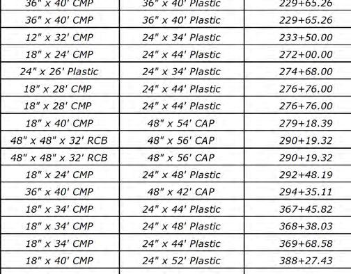
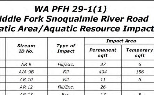
4 ftp:// /std_plan/wf0290stream _im pact.dgn [US_Sur_ft2D] 26-Jul-203 0:45 AM Designed by: B. W ACKER Reference umber: Applicant ame: Federal Highway Administration Sheet 4 of 73 AQUATIC AREA/AQUATIC RESOURCE IMPACT AREAS UMBER
![ftp://98.45.88.2/std_plan/wf0290ditch.dgn [US_Sur_ft2D] 7-Jul-203 08:46 AM Designed by: B.](/docs-images/94/119662370/images/5-0.jpg "W ACKER Reference umber: Applicant ame: Federal Highway Administration Sheet 5 of 73 JURISDICTIOAL DITCH")
5 ftp:// /std_plan/wf0290ditch.dgn [US_Sur_ft2D] 7-Jul :46 AM Designed by: B. W ACKER Reference umber: Applicant ame: Federal Highway Administration Sheet 5 of 73 JURISDICTIOAL DITCH IMPACT AREAS UMBER
6 $PATH$ $DATE$ Designed by: /202 Checked by:. BELL 2/202 Clearing lim its Clearing lim its Placing conserved topsoil, 6-inch depth 5' Variable Placing conserved topsoil, 6-inch depth 5' Original ground Variable Original ground Reference umber: Applicant ame: Federal Highway Administration Sheet 6 of :3 :3 3 3 LC 0' 0' Traveled way Safety edge detail 5 2% 2% Suitable roadway excavation or unclassified borrow Traveled way TYPICAL SECTIO O to to to to to LC 9' 9' Traveled way 5 Safety edge detail 2% Suitable roadway excavation or unclassified borrow Traveled way 2% TYPICAL SECTIO O to to to :3 :3 4 4 Placing conserved topsoil, 6-inch depth Var. 24 Variable Variable 26 Superpave pavement, 2" or 3 4" nominal maximum size aggregate, 0.3 to < 3 million ESAL, type V pavement roughness, 3-inch compacted depth, placed in two equal lifts Tack coat grade CSS-, CSS-h, SS-, or SS-h (between lifts) Aggregate base grading D, 6-inch compacted depth Placing conserved topsoil, 6-inch depth Var. 24 Superpave pavement, 2" or 3 4" nominal maximum size aggregate, 0.3 to < 3 million ESAL, type V pavement roughness, 3-inch compacted depth, placed in two equal lifts 2 Tack coat grade CSS-, CSS-h, SS-, or SS-h (between lifts) 6 5' ' m in. 5' Aggregate base grading D, 6-inch compacted depth ' m in. Clearing Clearing lim its lim its O SCALE OTE: FOOTOTE: See sheet C.5 for cut and fill slope rounding details. 2. See sheet C.6 for roadway width transition detail. Superelevate roadway on curves at the rate 'e' as indicated on the plan and profile curve data. Construct slopes as shown in the Staking Report. See guardrail detail on sheet C.5 for variances. See rockfall ditch detail on sheet C.6 for variances. See sheet C.6. TYPICAL SECTIOS UMBER See Standard 602-6, "Pipe Culvert Inlet Treatment in Cut Slopes" for variances. C.2
7 $PATH$ $DATE$ Designed by: /202 Checked by:. BELL 2/202 Clearing lim its Clearing lim its Placing conserved topsoil, 6-inch depth Variable Placing conserved topsoil, 6-inch depth Variable Original ground Reference umber: Applicant ame: Federal Highway Administration Sheet 7 of 73 5' 5' Original ground 2 2 :3 :3 3 3 LC 9' 9' Traveled way Traveled way 5 Safety edge detail 2% 2% Suitable roadway excavation or unclassified borrow 2% TYPICAL SECTIO O to to to LC 0' 0' Traveled way Traveled way Safety edge detail 5 Suitable roadway excavation or unclassified borrow 2% TYPICAL SECTIO O to to to '.5' 5' Placing conserved topsoil, 6-inch depth Variable 2 Curb and gutter, concrete, 2-inch depth 4 Superpave pavement, 2" or 3 4" nominal maximum size aggregate, 0.3 to < 3 million ESAL, type V pavement roughness, 3-inch compacted depth, placed in two equal lifts Tack coat grade CSS-, CSS-h, SS-, or SS-h (between lifts) Aggregate base grading D, 6-inch compacted depth 5' Placing conserved topsoil, 6-inch depth Variable 2 Curb and gutter, concrete, 2-inch depth4 Superpave pavement, 2" or 3 4" nominal maximum size aggregate, 0.3 to < 3 million ESAL, type V pavement roughness, 3-inch compacted depth, placed in two equal lifts Tack coat grade CSS-, CSS-h, SS-, or SS-h (between lifts) Aggregate base grading D, 6-inch compacted depth Clearing Clearing lim its lim its O SCALE OTE: FOOTOTE:. See sheet C.5 for cut and fill slope rounding details. 2. See sheet C.6 for roadway width transition detail. Superelevate roadway on curves at the rate 'e' as indicated on the plan and profile curve data. 2 Construct slopes as shown in the Staking Report. 3 See guardrail detail on sheet C.5 for variances. 4 See sheet K.. 5 See sheet C.6. TYPICAL SECTIOS UMBER C.3
8 $PATH$ $DATE$ Designed by: /202 Checked by:. BELL 2/202 Clearing lim its Original ground Reference umber: Applicant ame: Federal Highway Administration Sheet 8 of 73 Clearing lim its Placing conserved topsoil, 6-inch depth 5' Original ground Placing conserved topsoil, 6-inch depth 2 2 Variable :3 5 Flexible delineator 5' Variable :3 6' 4' 2' 0' Traveled way 2% Suitable roadway excavation or unclassified borrow LC 2% 0' Traveled way TYPICAL SECTIO O to to ' Traveled way 2% Suitable roadway excavation or unclassified borrow LC 0' Traveled way 2% TYPICAL SECTIO O to :3 :3 3 Placing conserved topsoil, 6-inch depth Variable Surface treatment, designation 2B Aggregate base grading D, 2-inch compacted depth, placed in two equal lifts 3 Variable ' m in. Placing conserved topsoil, 6-inch depth Surface treatment, designation 2B Aggregate base grading D, 2-inch compacted depth, placed in two equal lifts 5' 5' ' m in. O SCALE Clearing Clearing lim its lim its OTE: FOOTOTE: See sheet C.5 for cut and fill slope rounding details. 5 Superelevate roadway on curves at the rate 'e' as indicated on the plan and profile curve data. Construct slopes as shown in the Staking Report. See rockfall ditch detail on sheet C.6 for variances. TYPICAL SECTIOS UMBER See Standard 602-6, "Pipe Culvert Inlet Treatment in Cut Slopes" for variances. See sheet M.29. C.4
9 $PATH$ $DATE$ Designed by: /202 Checked by:. BELL 2/202 Original ground Reference umber: Applicant ame: Federal Highway Administration Sheet 9 of 73 Clearing lim its D B = 5' 0.25 D CUT SLOPE ROUDIG DETAIL 4 5' Slope stake Variable 3 :3 Original ground Clearing lim its Slope stake Slope stake 5' 5' Traveled way Safety edge detail 2 2% LC Traveled way 2% TYPICAL SECTIO O to D 0.25 D FILL SLOPE ROUDIG DETAIL 9' 9' Variable 3 Original ground Finished grade Edge of traveled way :3 Superpave pavement, 2" or 3 4" nominal maximum size aggregate, 0.3 to < 3 million ESAL, type V pavement Roadway reconditioning 5 Variable roughness, 3-inch compacted depth, placed in two equal lifts Tack coat grade CSS-, CSS-h, SS-, or SS-h (between lifts) Aggregate base grading D, 6-inch compacted depth :.5 Original ground 6 Variable Variable GUARDRAIL DETAIL 3 O SCALE FOOTOTE: Adjust to meet field conditions. Match existing superelevation on curves as approved by CO. See sheet C.6. Construct slopes as shown in the Staking Report. For cut heights less than "B" reduce "B" to the cut height dimension and reduce the front slope rounding distance proportionally. Two feet minimum. Construct widening as shown in Staking Report. TYPICAL SECTIOS UMBER Two feet minimum for 6' guardrail posts, zero for 7' guardrail posts. Construct widening as shown in Staking Report. C.5
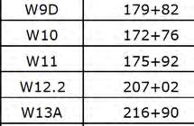
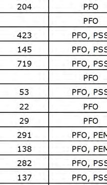
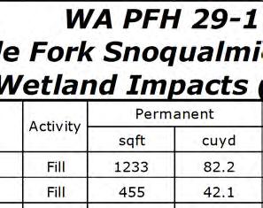
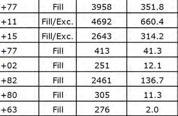
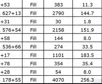
10 220 ftp:// /std_plan/wf0290ta.dgn [US_Sur2D] 29-Jul-203 :49 AM Designed by:. BELL Reference umber: Applicant ame: Federal Highway Administration Sheet 0 of 73 WETLAD/IMPACT LEGED: Temporary Wetland/Stream Impacts 790 Top of proposed cut K = 67 Deep patch, LT 790 Cut/fill transition % Clearing and grubbing limit 50' VC 780 Jurisdictional ditch W0 temporary impact 38 SQFT W SQ. METERS ACRES B % SSD = 353' K = 39 W SQ. METERS ACRES UPLAD 75 WETLAD EXTEDS UPLAD W9 permanent impact 4,070 SQFT W9 temporary impact 3,986 SQFT W temporary impact 30 SQFT W permanent impact 7 SQFT % UPLAD W9B SQ. METERS ACRES WETLAD EXTEDS W9B temporary impact 297 SQFT W9B permanent impact 455 SQFT W9D temporary impact 584 SQFT W9D permanent impact 800 Delineated Wetlands or Streams Special rock embankment, type 2, LT 800 Special rock embankment, type 2, LT Permanent Wetland/Stream Impacts ' VC See sheet K.4 Subgrade stabilization, type Toe of proposed fill See sheet C Refer to Middle Fork Snoqualmie River Road Right-of-Way Plans for permanent and construction easement boundary descriptions and locations. PLA AD PROFILE LEGED: Culvert inlet/outlet ditch Terminal section, type Tangent or Flared Structure transition railing Rock embankment or buttress Energy dissipator Riprap ditch MIDDLE FORK SOQUALMIE Embankment volumes shown include special rock embankments. See sheet D. for complete excavation and embankment totals. T ST RIVER ROAD = E= Excavation volumes shown do not include conserved topsoil quantities. El.= F SE Middle Fork Road BEGI RECOSTRUCTIO :2 D :2 Typical inlet/outlet ditch Rolled erosion control product SE Lake Dorothy Road End of Couplet Special rock embankment, type 2, RT SQFT WETLAD EXTEDS W SQ. METERS ACRES W9D ACRES UMBER D.8 80 TL DH
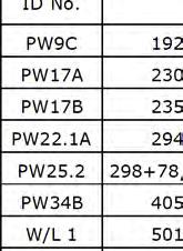
11 ftp:// /std_plan/wf0290tb.dgn [US_Sur2D] 29-Jul-203 2:3 PM Designed by:. BELL SQ. METERS ACRES TL DH-5 80 W9 permanent impact 4,070 SQFT W9 temporary impact Reference umber: 3,986 SQFT W9A SQ. METERS ACRES Applicant ame: Federal Highway Administration Sheet of Special rock embankment, type 2, LT Standard underdrain system, type, RT Subgrade stabilization, type 785 K = ' VC K = 7 400' VC Special rock embankment, type 2, RT See sheet C W9D temporary impact 584 SQFT W9D permanent impact 338 SQFT % W9A temporary impact,09 SQFT W9A permanent impact,233 SQFT Jurisdictional ditch # Parking Area 2 See sheet E SSD = 493' Parking Area See sheet E AR-9 2,78 (Includes 6 for approach road RT) " Pipe Culvert WETLAD EXTEDS W SQ. METERS ACRES Mainline = B Approach DR Parking Access See sheet E Remove existing AR 9 temporary impact drop inlet 6 SQFT AR 9 permanent impact 37 SQFT See sheet H.2 66 (Includes 54 for approach road RT) A/A 9B permanent impact A/A 9B temporary impact % 494 SQFT 56 SQFT PW9C ACRES PW9C permanent impact 65 SQFT PW9C temporary impact 50 SQFT AR 0 temporary impact AR 0 permanent impact AR-0 SQFT 37 5 SQFT K = A/A 9B ACRES " Pipe Culvert UMBER D
12 ftp:// /std_plan/wf0290tc.dgn [US_Sur2D] 29-Jul-203 2:33 PM Designed by:. BELL 755 Reference umber: TL CUT S- Applicant ame: Federal Highway Administration Sheet 2 of Special rock embankment, type 2, LT Special rock embankment, type 2, LT Subgrade stabilization, type Rock buttress, type, RT K = 03 50' VC ' VC % % 99+0 SSD = 753' K = K = 65 80' VC SSD = 902' 00' VC K = 79 00' VC % See sheet C.7 AR-A AR-2 WETLAD EXTEDS,034 (Includes 9 for approach road RT) Mainline = Approach 0+00 Granite Creek Rd See sheet E.2 W2.A SQ. METERS ACRES AR % 48" Pipe Culvert Q50=69 cfs HW 50=3.99 ft W SQ. METERS ACRES A See sheet K WETLAD EXTEDS AR 2 permanent impact 26 SQFT K = W SQ. METERS ACRES % " Pipe Culvert AR-3 TL DH-6 W2.2 permanent impact 96 SQFT W2.2 temporary impact 85 SQFT 288 (Includes 23 for approach road RT) SSD = 436' UMBER D.0 AR 3 permanent impact 7 SQFT AR 3 temporary impact 8 SQFT %
13 ftp:// /std_plan/wf0290td.dgn [US_Sur2D] 29-Jul-203 2:34 PM Designed by:. BELL 20 Reference umber: Applicant ame: Federal Highway Administration Sheet 3 of AR-4 B SQ. METERS ACRES A/A 3 AQUATIC AREA EXTEDS A/A SQ. METERS ACRES AQUATIC AREA EXTEDS AR-4. B-3 WETLAD EXTEDS W3A SQ. METERS ACRES 795 Special rock embankment, type 2, LT Special rock embankment, type 2, LT Rock buttress, type 2, RT Rolled erosion control product, type 3.B, RT Special rock embankment, type 2, LT K = 74 K = 59 00' VC K = 68 00' VC ' VC K = ' VC % SSD = 623' 775 SSD = 88' SSD = 395' 775 K = 76 K = 7 K = 44 00' VC 50' VC 50' VC AR 4 temporary impact Rolled erosion control product, type 3.B, RT 770 See sheet K Special rock embankment, type 2, LT SQFT AR 4 permanent impact 33 SQFT % See sheet K A/A 3 permanent impact 4 SQFT A/A 3 temporary impact 226 SQFT % See sheet K % ,077 W3A temporary impact 48 SQFT W3A permanent impact 244 SQFT W3A SQ. METERS ACRES WETLAD EXTEDS AR 5B temporary impact SQFT AR 5B permanent impact 220 AR 5 temporary impact % 405 SQFT 9 SQFT AR-5 Rolled erosion control product, type 4, RT " Pipe Culvert % 22+0 AR-5A AR-5B W4 temporary impact W4 permanent impact SQFT 48 SQFT See sheet K B-4 WETLAD EXTEDS W4A permanent impact % 207 SQFT W SQ. METERS 0.75 ACRES AR-6A W4A SQ. METERS ACRES % " Pipe Culvert UMBER D
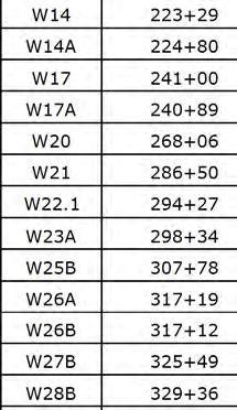
14 ftp:// /std_plan/wf0290te.dgn [US_Sur2D] 29-Jul-203 2:35 PM Designed by:. BELL W4A 9.22 SQ. METERS ACRES 225 Reference umber: Applicant ame: Federal Highway Administration Sheet 4 of 73 GR LT GR RT B-6 B-5 WC- B-7 B-75 AR-6 B-9 B-8 A/A 7A ACRES AR-6. AR-6 AR PW7A B ACRES Deep patch, LT Curb and gutter, RT Special rock embankment, type 3, LT Rolled erosion control product, type 4, RT Special rock embankment, type 3, LT 775 K = K = 56 K = 24 00' VC ' VC % AR 6 permanent impact SSD = 733' Middle Fork Snoqualmie River 760 Curb and gutter, RT 760 See sheet K. AR 6 temporary impact T 56 SQFT % 32 SQFT ' VC See sheet K " Pipe Culvert Manhole, with debris cage, RT PW7A permanent impact 92 SQFT PW7A temporary impact 206 SQFT A/A 7A permanent impact 559 SQFT A/A 7A temporary impact 54 SQFT % AR 8 permanent impact 34 SQFT AR 8 temporary impact SSD = 389' AR 6 temporary impact 7 SQFT B- DI AR-8 AR-8A AR-8 Inlet, type 7B, RT Parking Area 3 See sheet E.6 AR-9 AR-8B WETLAD EXTEDS 235 T PW7B ACRES Parking Area 4 See sheet E.6 See sheet K W SQ. METERS ACRES See sheet K.7,50,203, SQFT PW7B permanent impact 2,489 SQFT PW7B temporary impact 634 SQFT % UMBER D.2 GR LT GR RT
15 ftp:// /std_plan/wf0290tf.dgn [US_Sur2D] 29-Jul-203 2:36 PM Designed by:. BELL 2/202 WETLAD EXTEDS W7A SQ. METERS ACRES Reference umber: B-2 WETLAD EXTEDS WETLAD EXTEDS Applicant ame: Federal Highway Administration Sheet 5 of TL DH Rolled erosion control product, type 4, RT ' VC K = K = 35 SSD = 298' ' VC K = " Pipe Culvert Q50=69 cfs HW 50=3.64 ft % See sheet K.7 W7 permanent impact 838 SQFT W7 temporary impact 423 SQFT Parking Area 5 See sheet E.6 W7A permanent impact 356 SQFT W7A temporary impact 45 SQFT SSD = 636' +.88% K = % " Pipe Culvert 4, % ' VC TL CUT S % UMBER D
16 ftp:// /std_plan/wf0290tg.dgn [US_Sur2D] 29-Jul-203 2:38 PM Designed by:. BELL 255 Reference umber: Applicant ame: Federal Highway Administration Sheet 6 of 73 GR LT GR RT TL DH Special rock embankment, type, RT % 805 SSD = 262' 805 K = 54 K = ' VC SSD = 392' K = 00 K = 54 00' VC % " Pipe Culvert Q50=3 cfs HW 50=5.52 ft K = % AQUATIC AREA EXTEDS SQ. METERS A/A ACRES SQ. METERS WETLAD EXTEDS 60" Pipe Culvert Q50=3 HW 50=5.63 ft W8A ACRES Parking Area 6 See sheet E SQ. METERS ACRES W9 UPLAD Middle Fork Snoqualmie River SQ. METERS W20A ACRES SQ. METERS , % W20 temporary impact 79 SQFT W20 permanent impact SQFT W ACRES " Pipe Culvert % T UMBER D GR LT GR RT
17 ftp:// /std_plan/wf0290th.dgn [US_Sur2D] 29-Jul-203 2:39 PM Designed by:. BELL 270 Reference umber: B-3 Applicant ame: Federal Highway Administration Sheet 7 of 73 GR LT GR RT B-4 AR-20A B-5 AR B-6 AR-2A B-7 AR Curb and gutter, RT Curb and gutter, RT See sheet K. 830 See sheet K. 830 K = See sheet K See sheet K.7 K = ' VC 85 K = K = 67 SSD = 652' 00' VC K = ' VC Mechanically stabilized earth wall, welded wire face, LT 805 K = 00 00' VC AR 20 temporary impact % 3 SQFT " Pipe Culvert SSD = 2208' K = ' VC AR 20 permanent impact % SQFT AR 20 temporary impact Rolled erosion control product, type 4, RT SQFT AR 2A temporary impact % Inlet, type 7B, RT 5 SQFT AR 2 permanent impact 30 SQFT AR 2 temporary impact Deep patch, LT SQFT Inlet, type 7B, RT Middle Fork Snoqualmie River B-8 AR 22 permanent impact TL DH AR-22A B B-20 AR-22 48" Pipe Culvert Q50=2 cfs HW 50=.87 ft B-2 B ST B B-24 B-25 B-26 DI See sheet J.3 Moment slab guardrail, LT See sheet I. 6, SQFT AR 22 temporary impact % 37 SQFT USGS Gauging Station Do not disturb Install conduit, 2-inch, rigid galvanized steel See sheet K % SSD = 682' 00' VC % B % 285 B-27 UMBER D.5 GR LT GR RT
18 ftp:// /std_plan/wf0290ti.dgn [US_Sur2D] 29-Jul-203 2:40 PM Designed by:. BELL GR LT GR RT B-27 W2 permanent impact Reference umber: B-29 Applicant ame: Federal Highway Administration Middle Fork 02.8 SQ. METERS W ACRES Sheet 8 of 73 DI B AR A/A SQ. METERS ACRES WETLAD EXTEDS 2.52 SQ. METERS ACRES AR Special rock embankment, type 2, LT Special rock embankment, type 2, LT Deep patch, LT SSD = 40' 825 SSD = 325' Standard underdrain system, type 2, RT Moment slab guardrail, LT Rolled erosion control product, type 4, RT Mechanically stabilized earth wall, welded wire face, LT Moment slab guardrail, LT ST K = 35 50' VC 24" Pipe Culvert,00 SQFT ST % See sheet I. Snoqualmie River Special rock embankment, type 3, LT K = 56 50' VC See sheet J.3 ST % AR 23 permanent impact See sheet I A/A 22 permanent impact 62 SQFT AR 23 temporary impact K = 47 50' VC 4 SQFT ,668 AR 24 temporary impact 69 SQFT " Pipe Culvert Q50=72 cfs HW 50=4.29 ft 4 SQFT AR 24 permanent impact 33 SQFT T % See sheet K.4 Jurisdictional ditch # See sheet K.7 A/A 22.A temporary impact W SQFT A/A 22.A permanent impact 29 SQFT AQUATIC AREA EXTEDS 2, SQ. METERS ACRES B SQ. METERS ACRES W A/A 22.A K = 53 50' VC " Pipe Culvert Q50=63 cfs HW 50=3.70 ft W23A permanent impact SQFT 62 SQFT PW22.A 53 SQFT PW25.2 temporary impact 323 SQFT W23A temporary impact WETLAD EXTEDS PW22.A temporary impact PW22.A permanent impact W22. temporary impact 362 SQFT PW25.2 permanent impact 22 SQFT % 2,903 SQFT W23A SQ. METERS ACRES See sheet H PW25.2 WETLAD EXTEDS " Pipe Culvert Q50 = 63 cfs HW 50=3.76 ft UMBER D.6 GR LT GR RT
19 ftp:// /std_plan/wf0290tj.dgn [US_Sur2D] 29-Jul-203 2:4 PM Designed by:. BELL 805 Parking Area 7 See sheet E Reference umber: PW25.2 Applicant ame: Federal Highway Administration Sheet 9 of TL DH-0 WETLAD EXTEDS PW25.2 W25B SQ. METERS ACRES K = K = 25 00' VC % 825 Standard underdrain system, type 2, LT Standard underdrain system, type 2, RT SSD = 682',000' VC See sheet H.2 See sheet H.2 PW25.2 permanent impact 2,903 SQFT PW25.2 temporary impact 362 SQFT % 00' VC , W25B temporary impact 29 SQFT W25B permanent impact 9 SQFT % WETLAD EXTEDS K = WETLAD EXTEDS W25A SQ. METERS ACRES % UMBER 35 D
20 ftp:// /std_plan/wf0290tk.dgn [US_Sur2D] 29-Jul-203 2:42 PM Designed by:. BELL Reference umber: GR LT GR RT WETLAD EXTEDS Applicant ame: Federal Highway Administration Sheet 20 of 73 W26A 24.2 SQ. METERS ACRES WETLAD EXTEDS W26B SQ. METERS ACRES WETLAD EXTEDS TL DH W SQ. METERS ACRES K = SSD = 2566' ' VC % W26B temporary impact 38 SQFT W26B permanent impact 75 SQFT Jurisdictional ditch # W26A temporary impact 29 SQFT W26A permanent impact 94 SQFT SSD = 45' K = 0 See sheets G.-G % Parking Area 8 See sheet E ' VC Parking Area 9 See sheet E.6 WETLAD EXTEDS W27B temporary impact W27B permanent impact WETLAD EXTEDS -5% % 282 SQFT 97 SQFT 33 A A % 44 W27B SQ. METERS ACRES W27A SQ. METERS ACRES Middle Fork Snoqualm ie River Existing Bridge Rehabilitate bridge deck T ST T ST See sheets G.-G W28B permanent impact Middle Fork Snoqualmie River Existing Bridge Rehabilitate bridge deck 59 SQFT AQUATIC AREA EXTEDS W28B temporary impact 37 SQFT W28B SQ. METERS ACRES , K = ' VC % % ST T ST T K = 63 00' VC UMBER D.8 GR LT GR RT
21 ftp:// /std_plan/wf0290tl.dgn [US_Sur2D] 29-Jul-203 2:42 PM Designed by:. BELL 330 Reference umber: AQUATIC AREA EXTEDS Applicant ame: Federal Highway Administration Sheet 2 of A/A 28./ SQ. METERS ACRES WETLAD EXTEDS AR-28. AQUATIC AREA EXTEDS W29A SQ. METERS ACRES ' VC SSD = 3952' K = 63 00' VC % K = ' VC B , % SSD = 900' K = 7 W29B temporary impact Existing Bridge. Remove bridge. W29A temporary impact 4 SQFT W29A permanent impact 49 SQFT 49 SQFT W29B permanent impact 22 SQFT % Existing Bridge. Remove bridge ft span x 6 ft rise box culvert Q50=235 cfs HW 50=3.5 ft UMBER D
22 345 ftp:// /std_plan/wf0290tm.dgn [US_Sur2D] 29-Jul-203 2:43 PM Designed by:. BELL W29B SQ. METERS ACRES Reference umber: WETLAD EXTEDS Applicant ame: Federal Highway Administration Sheet 22 of WETLAD EXTEDS W30B SQ. METERS 0.98 ACRES TL DH K = % K = SSD = 2042' 00' VC K = 85 00' VC % W30B temporary impact 247 SQFT W30B permanent impact 52 SQFT SSD = 800' % AR AR-3.2 WETLAD EXTEDS AR ' VC AR-3. AR-3. W SQ. METERS ACRES WETLAD EXTEDS % UMBER 360 D
23 ftp:// /std_plan/wf0290tn.dgn [US_Sur2D] 29-Jul-203 2:44 PM Designed by:. BELL 360 Reference umber: 845 Applicant ame: Federal Highway Administration Sheet 23 of WETLAD EXTEDS AR-32.4 W32A SQ. METERS ACRES B-33 AR Curb and gutter, LT Special rock embankment, type 2, RT See sheet K K = K = % K = SSD = 226' % AR 32.3 permanent impact 36 SQFT AR 32.3 temporary impact 5 SQFT See sheet K. Special rock embankment, type 2, RT AR 32.B permanent impact 25 SQFT AR 32.B temporary impact 9 SQFT AR-32.2 WETLAD EXTEDS Deep patch, RT " Pipe Culvert AR-32.B B , ' VC AR 32.2 temporary impact 6 SQFT AR 32.2 permanent impact 0 SQFT % SSD = 82' 00' VC % 375 UMBER D
24 380 ftp:// /std_plan/wf0290to.dgn [US_Sur2D] 29-Jul-203 2:45 PM Designed by:. BELL 375 Reference umber: Applicant ame: Federal Highway Administration Sheet 24 of 73 TL DH % AR 33.2A permanent impact 9 SQFT AR 33.2A temporary impact 5 SQFT 900 Deep patch, RT K = ' VC Special rock embankment, type 2, RT SSD = 60' WETLAD EXTEDS Special rock embankment, type 2, RT % AR-33.2A W33B SQ. METERS ACRES See sheet K , B-35 AR-33. UMBER D
25 ftp:// /std_plan/wf0290tp.dgn [US_Sur2D] 29-Jul-203 2:46 PM Designed by:. BELL 390 Reference umber: WETLAD EXTEDS AR-33.A Applicant ame: Federal Highway Administration Sheet 25 of B-36 AQUATIC AREA EXTEDS 395 B B-38 A/A 34A SQ. METERS ACRES AQUATIC AREA EXTEDS B Deep patch, RT Special rock embankment, type 2, RT Special rock embankment, type, RT 890 K = ' VC 885 SSD = 273' ' VC See sheet K Special rock embankment, type 2, RT % 24" Pipe Culvert See sheet K K = ' VC AR 33.A permanent impact 36 SQFT AR 33.A temporary impact 7 SQFT % " Pipe Culvert AQUATIC AREA EXTEDS A/A 34A temporary impact 540 SQFT A/A 34A permanent impact,004 SQFT % 82 3,257 6, % AR-34B B-4 B AR-34A AR 34B temporary impact 5 SQFT AR 34B permanent impact 7 SQFT B-42 A/A 34A.9332 ACRES B-44 B-43 AR 34A permanent impact 29 SQFT AR 34A temporary impact 5 SQFT SQ. METERS Special rock embankment, type 2, RT SSD = 293' K = 40 Deep patch, RT B-46 B-45-5.% UMBER D
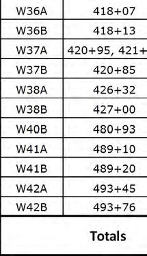
26 ftp:// /std_plan/wf0290tq.dgn [US_Sur2D] 29-Jul-203 2:47 PM Designed by:. BELL 405 Reference umber: PW34B SQ. METERS ACRES WETLAD EXTEDS TL DH-5 A/A 34A Special rock embankment, type 2, LT & RT Special rock embankment, type 2, RT K = 29 K = ' VC SSD = 437' 250' VC SSD = 25' K = 63 K = 29 SSD = 276' ' VC K = Rolled erosion control product, type 3.B, LT & RT PW34B temporary impact 96 SQFT Applicant ame: Federal Highway Administration Sheet 26 of PW34B permanent impact 23 SQFT 247" x 58" SPPA Q50=596 cfs HW 50=5.54 ft A/A 34A temporary impact 278 SQFT A/A 34A temporary impact 455 SQFT A/A 34A permanent impact,07 SQFT % A/A 34A permanent impact 472 SQFT % W35A permanent impact 68 SQFT W35A temporary impact 30 SQFT 4+25 W35B temporary impact 395 SQFT AR 35 temporary impact 2 SQFT AR 35 permanent impact 23 SQFT W35B permanent impact 765 SQFT % WETLAD EXTEDS W35A 46.6 SQ. METERS ACRES WETLAD EXTEDS AR-35 B W35B SQ. METERS ACRES AR-35B WETLAD EXTEDS W36B SQ. METERS ACRES WETLAD EXTEDS W36A SQ. METERS ACRES , " Pipe Culvert Extend ex. inlet % W36B permanent impact 49 SQFT W36B temporary impact 42 SQFT W36A permanent impact 622 SQFT W36A temporary impact 9 SQFT See sheet K.7 WETLAD EXTEDS Rolled erosion control product, type 3.B, LT See sheet K % UMBER D
27 ftp:// /std_plan/wf0290tr.dgn [US_Sur2D] 29-Jul-203 2:48 PM Designed by:. BELL 420 WETLAD EXTEDS W37A temporary impact 77 SQFT W37A permanent impact 270 SQFT Reference umber: 900 W37A SQ. METERS ACRES WETLAD EXTEDS W37B SQ. METERS ACRES Applicant ame: Federal Highway Administration Sheet 27 of WETLAD EXTEDS W38A SQ. METERS ACRES WETLAD EXTEDS K = K = ' VC 95 SSD = 928' 95 K = 65 K = 8 00' VC % " Pipe Culvert " Pipe Culvert W37B temporary impact 89 SQFT W37B permanent impact 73 SQFT % % W38B 08.6 SQ. METERS ACRES TL DH-6 W38A temporary impact 27 SQFT 3,845 (Includes 23 for approach road LT) WETLAD EXTEDS W38B temporary impact 296 SQFT W38A permanent impact 337 SQFT % A Mainline = Approach Bessemer Rd See sheet E (Includes 79 for approach road LT) TL CUT S UMBER 435 SSD = 40' D
28 ftp:// /std_plan/wf0290ts.dgn [US_Sur2D] 29-Jul-203 2:49 PM Designed by:. BELL TL CUT S Reference umber: B-73 Applicant ame: Federal Highway Administration Sheet 28 of WETLAD EXTEDS B TL CUT S W39.3B SQ. METERS ACRES B Deep patch, RT Deep patch, LT Subgrade stabilization, type See sheet K Deep patch, LT 945 See sheet K See sheet K K = 56 K = % 930 K = ' VC % Parking Area 0 See sheet E Subgrade stabilization, type K = ' VC See sheet C , SSD = 305' % , % WETLAD EXTEDS SSD = 685' TL DH-7 See sheet C % UMBER D
29 ftp:// /std_plan/wf0290tt.dgn [US_Sur2D] 29-Jul-203 :46 AM Designed by:. BELL 450 Reference umber: Applicant ame: Federal Highway Administration Sheet 29 of AR WETLAD EXTEDS B-49 A/A 39.2B SQ. METERS ACRES B-50 PW39.2B 930 Subgrade stabilization, type % SSD = 3838' 95 K = ' VC See sheet C SSD = 8873' ,88 Jurisdictional ditch # % 2,998 WETLAD EXTEDS Remove gate K = 88 00' VC -.607% " Pipe Culvert UMBER D
30 ftp:// /std_plan/wf0290tu.dgn [US_Sur2D] 29-Jul-203 2:50 PM Designed by:. BELL Reference umber: Applicant ame: Federal Highway Administration Sheet 30 of 73 GR LT GR RT A/A 39.A SQ. METERS ACRES B-5 B-52 TL DH K = ' VC % % SSD = 065' K = Bridge. 885 See sheets G.3-G B-54 B-53 A/A 39.B SQ. METERS ACRES T ST ST T T ST ST T K = 59 60' VC Remove existing bridge and construct new bridge Bridge. Remove existing bridge. See Subsections A and B for removal requirements. Construct new bridge. See sheets G.3-G % 4,24 2, A/A 39.B temporary impact 4,53 SQFT ' VC W39A 53.2 SQ. METERS ACRES Middle Fork Snoqualm ie River % WETLAD EXTEDS UMBER D.28 GR LT GR RT
31 ftp:// /std_plan/wf0290tv.dgn [US_Sur2D] 29-Jul-203 2:5 PM Designed by:. BELL 480 Reference umber: W40B SQ. METERS ACRES WETLAD EXTEDS 485 TL CUT S-8 TL DH K = 94 50' VC SSD = 476' 905 K = 02 K = 00 00' VC 400' VC Applicant ame: Federal Highway Administration Sheet 3 of Parking Area See sheet E % W40B temporary impact 738 SQFT W40B permanent impact 35 SQFT Mdidel Fokr Snoquaml ei Rvier WETLAD EXTEDS W4A SQ. METERS ACRES " Pipe Culvert Q50=6 cfs HW 50=4.63 ft WETLAD EXTEDS W4B SQ. METERS ACRES WETLAD EXTEDS W42A 45.9 SQ. METERS 0.7 ACRES AR-42 W42B SQ. METERS ACRES ,376 W4B temporary impact 52 SQFT W4B permanent impact 90 SQFT W4A permanent impact 44 SQFT W4A temporary impact 59 SQFT % W42A temporary impact 6 SQFT K = W42B temporary impact 2 SQFT % " Pipe Culvert Q50=292 cfs HW 50=7.5 ft WETLAD EXTEDS 495 UMBER D.29 W42A permanent impact 235 SQFT
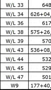
32 ftp:// /std_plan/wf0290tw.dgn [US_Sur2D] 29-Jul-203 2:52 PM Designed by:. BELL Reference umber: Applicant ame: Federal Highway Administration Sheet 32 of 73 DCP W/L W/L K = 00 00' VC W/L 47 permanent impact 54 SQFT W/L 47 temporary impact 24 SQFT % " Pipe Culvert Q50=6 cfs HW 50=6.28 ft W/L temporary impact 38 SQFT ,289 Special rock embankment, type 2, RT K = 06 00' VC A/R % UMBER 50 D
33 ftp:// /std_plan/wf0290tx.dgn [US_Sur2D] 29-Jul-203 2:53 PM Designed by:. BELL Reference umber: Applicant ame: Federal Highway Administration Sheet 33 of 73 W/L W/L K = 49 SSD = 627' 50' VC 920 K = 2 K = SSD = 88' % W/L 2 permanent impact 26 SQFT W/L 2 temporary impact 5 SQFT SSD = 673' K = 45 W/L 3 permanent impact 53 SQFT W/L 3 temporary impact 47 SQFT A/A 46 permanent impact 83 SQFT ' VC A/A 46 temporary impact 202 SQFT % ' VC , % A/A 46 W/L 4 permanent impact 5 SQFT Parking Area 2 W/L 4 temporary impact 50 SQFT See sheet E W/L K = 77 00' VC TL DH W/L 5 temporary impact 779 SQFT DCP-24,WC-7 A/A 46 permanent impact 22 SQFT W/L 5 permanent impact 372 SQFT A/A 46 temporary impact 46 SQFT % W/L 5 A/R 2 permanent impact 42 SQFT A/R 2 temporary impact 38 SQFT A/A 46 permanent impact 75 SQFT A/A 46 temporary impact 09 SQFT % ' VC " Pipe Arch Q50=279 cfs HW 50=4.88 ft UMBER D A/R
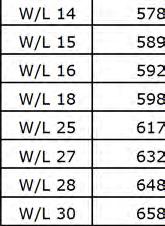
34 ftp:// /std_plan/wf0290ty.dgn [US_Sur2D] 29-Jul-203 2:54 PM Designed by:. BELL A/R Reference umber: Applicant ame: Federal Highway Administration Sheet 34 of W/L 6 temporary impact 4 SQFT W/L 6 W/L WC-6 B-55 W/L 7 W/L Special rock embankment, type, LT Special rock embankment, type, RT W/L 45 permanent impact 354 SQFT W/L 45 temporary impact 389 SQFT " Pipe Culvert Q50=9 cfs HW 50=2.07 ft 8, % " Pipe Culvert W/L 7 permanent impact 7,374 SQFT W/L 7 temporary impact 4,735 SQFT W/L 44 permanent impact,0 SQFT W/L 44 temporary impact 387 SQFT WC-5 W/L 7 B-56 WC-4 W/L " Pipe Culvert Q50=9 cfs HW 50=.85 ft W/L 43 permanent impact 274 SQFT W/L 43 temporary impact 35 SQFT UMBER D
35 " Pipe Culvert " Pipe Culvert " Pipe Culvert ftp:// /std_plan/wf0290tz.dgn [US_Sur2D] 29-Jul-203 2:55 PM Designed by:. BELL Reference umber: Parking Area 3 See sheet E.6 Applicant ame: Federal Highway Administration Sheet 35 of W/L SI&VWP Middle Fork Snoqualmie River B Subgrade stabilization, type Deep patch, RT Rolled erosion control product, type 3.B, LT K = 68 SSD = 349' SSD = 9' ' VC K = K = 7 50' VC K = ' VC % See sheet K W/L 8 permanent impact 4,52 SQFT W/L 8 temporary impact 3,493 SQFT See sheet C % SI&VWP B SI&VWP B Parking Area 4 See sheet E.6 W/L 42 B-60 See sheet K.4 A/R 6 temporary impact 2 SQFT A/R 6 permanent impact 45 SQFT B-6 A/R % K = ' VC % UMBER 555 D
36 ftp:// /std_plan/wf0290ua.dgn [US_Sur2D] 29-Jul-203 2:56 PM. BELL Checked by: 2/202 Designed by: Reference umber: B-62 A/R 6 W/L 9 Applicant ame: Federal Highway Administration Sheet 36 of 73 B-63 TL CUT S-6 B-65 SI&VWP B-64 SI&VWP W/L TL DH-2 Middle Fork Snoqualmie River SSD = 9' A/R 0A 980 Deep patch, RT Subgrade stabilization, type Deep patch, RT Subgrade stabilization, type Rolled erosion control product, type 3.B, LT 970 SSD = 228' See sheet K.7 K = 24 K = 66 K = 6 500' VC ' VC % K = ' VC A/R 6 temporary impact 20 SQFT A/R 6 permanent impact 69 SQFT See sheet K.4 K = " Pipe Culvert % W/L 9 temporary impact 69 SQFT W/L 9 permanent impact 78 SQFT See sheet C % A/R 0A permanent impact 353 SQFT Jurisdictional ditch # See sheet K.4 A/R 0 temporary impact 0 SQFT A/R 0 permanent impact 763 SQFT B ,676 A/A 40 A/R 3 permanent impact 279 SQFT A/R 4 permanent impact 22 SQFT A/R A/R 3 A/R 3 See sheet C.7 A/A temporary impact 806 SQFT A/A permanent impact 306 SQFT, , % SSD = 48' ft span x 5 ft rise Precast reinforced concrete box culvert, grated top A/R 4 Q50=80 cfs HW 50=6.2 ft % A/A A/R 4 4 ft span x 7 ft 6 inch rise Precast reinforced concrete box culvert, grated top Q50=80 cfs HW 50=5.4 ft B Ex. 36" Pipe Culvert Do ot Disturb +2.88% UMBER D
37 ftp:// /std_plan/wf0290ub.dgn [US_Sur2D] 29-Jul-203 2:57 PM Designed by:. BELL W/L 39 Reference umber: W/L W/L 3 W/L Special rock embankment, type, LT & RT K = ' VC K = " Pipe Culvert Q50=36 cfs HW 50=2.62 ft A/A temporary impact 806 SQFT Applicant ame: Federal Highway Administration Sheet 37 of % A/A permanent impact 306 SQFT W/L 39 permanent impact 44 SQFT SSD = 428' W/L 2 temporary impact 630 SQFT W/L 2 permanent impact 426 SQFT Jurisdictional ditch #2 -.% W/L 3 temporary impact 436 SQFT W/L 3 permanent impact 403 SQFT " Pipe Culvert Q50=36 cfs HW 50=2.97 ft K = W/L 38 temporary impact 3,664 SQFT W/L 38 permanent impact 2,58 SQFT 5, % B-76 W/L 4 temporary impact 3,36 SQFT W/L 4 permanent impact 3,958 SQFT W/L 4 DCP-23,WC-3 WC-2 DCP DCP-20 DCP % UMBER D
 203.0100 Removing Small Pipe Culverts CATEGORY STATION LOCATION EACH 0010 2+00-16+50 0010 7+13-8+41 LT. 155 3 0010 4+42 CL 1 10,660 9+90-13+73 RT. 390 3 7+63'SB' 67' LT. 1 14+25'GV' 49' LT. 1 17+05'GV'
DRAFT. Dorabelle Campground Rehabilitation
 DRAFT Dorabelle Campground Rehabilitation September 2012 1.1 REGIONAL SETTING AND PROJECT LOCATION The Dorabelle Campground is located on the western shore of Shaver Lake in Fresno County, California (Section
BID FORM. Bid by: Name of Bidder. Address: Address: To the Texas Department of Transportation hereinafter called the Agent.
 BID FORM TxDOT CSJ No. Project Description: This project includes reconstruction of a hangar access taxiway with trench drain and pipe drainage system; local reconstruction of failing pavement on Taxiway
Kansas Department of Transportation DISTRICT TE / TA-T043(301) Project(s): Min: Max:
 Project(s): Min: Max:") Page 1 of 20 518045 SECTION: 01 COMMON ITEMS 1 020100 CONTRACTOR CONSTRUCTION STAKING 2 025600 FIELD OFFICE AND LABORATORY (TYPE A) 3 012340 FOUNDATION STABILIZATION (SET PRICE) 4 025323 MOBILIZATION 5
Page 1 of 20 518045 SECTION: 01 COMMON ITEMS 1 020100 CONTRACTOR CONSTRUCTION STAKING 2 025600 FIELD OFFICE AND LABORATORY (TYPE A) 3 012340 FOUNDATION STABILIZATION (SET PRICE) 4 025323 MOBILIZATION 5
ADVANCED WARNING SYSTEM FOR SHARED USE CROSSING ON HOWARD STREET EAST OF NORDICA AVENUE
 ADVANCED WARNING SYSTEM FOR SHARED USE CROSSING ON EAST RDICA AVENUE FOR THE LOCATION MAP STANDARD SYMBOLS FEATURE EISTING PROPOSED BENCHMARK BM/TBM SHEET INDE. BM/TBM TITLE SHEET CONCRETE R.O.W. MONUMENT
ADDENDUM NO. TWO AB
 ADDENDUM NO. TWO AB2018-28 Notice is hereby given that on June 22, 2018 at 11:00 A.M. (Prevailing time), sealed bids will be opened and read in public by the Purchasing Department in the Mercer County
Section 3-04 Cross Sectional Elements TABLE OF CONTENTS. INTRODUCTION...3 General...3 Exhibit 1-Cross-Sectional Elements...3
 Section 3-04 Cross Sectional Elements TABLE OF CONTENTS INTRODUCTION...3 General...3 Exhibit 1-Cross-Sectional Elements...3 CROSS-SECTIONAL ELEMENTS...3 Traveled Way...3 Shoulder...3 Surfacing Taper...3
COATING AND STRUCTURAL CONCRETE COATING (ANTI-GRAFFITI) 1'-3" FINISHED GRADE 1'-3" 3" VENEER ALLOWANCE LEDGER W/ MECHANICAL ANCHOR BOLT
 1'-3 FINISHED GRADE 1'-3 3 VENEER ALLOWANCE LEDGER W/ MECHANICAL ANCHOR BOLT") R "W" PAY LIMITS OF ITEM 601 PAY LIMITS OF ITEM 601 STRUCTURAL CONCRETE STRUCTURAL CONCRETE 1'3" PCBC END SEGMENT B C 1'3" COATING AND STRUCTURAL CONCRETE COATING (ANTIGRAFFITI) 1'3" CURB FINISHED GRADE
R "W" PAY LIMITS OF ITEM 601 PAY LIMITS OF ITEM 601 STRUCTURAL CONCRETE STRUCTURAL CONCRETE 1'3" PCBC END SEGMENT B C 1'3" COATING AND STRUCTURAL CONCRETE COATING (ANTIGRAFFITI) 1'3" CURB FINISHED GRADE
Item Description Unit Quantity Unit Price Total Unit Price Total Unit Price Total Unit Price Total Unit Price Total Unit Price Total
 AGENCY: KENDALL Builders Paving D Construction, Inc. Gallagher Asphalt Corp. Geneva Construction Co. P. T. Ferro Construction Co. SECTION: 16-00000-00-GM, Plainfield Road, HMA Resurfacing, CMF 4413 Roosevelt
Datum on benchmarks All benchmarks with a Township name and number are on 1929 datum:. All benchmarks with a four-digit number are on 1988 datum:
 Datum on benchmarks All benchmarks with a Township name and number are on 1929 datum:. All benchmarks with a four-digit number are on 1988 datum: LAWRENCE 2 Destroyed 8/29/05 TG General coordinates: 10800E
IS A BUDGET ONLY DESCRIPTION QUANTITY UNIT
 Miller Creek Consultants LLC CONCRETE RECAP 1/29/2009 ESTIMATE DATE: 1-Jan-09 Project: 4000 psi 95.00 Location: 3000 psi 88.00 PROJECT DATA PROJECT NAME: Concrete Estimate THIS IS A BUDGET ONLY DESCRIPTION
Ditch flows slowly to the north
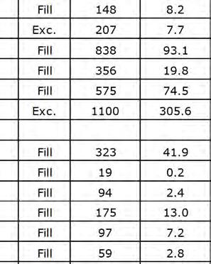
 Ditch flows slowly to the north Photo 1. Wetland DE: Looking west across Wetland DE from upslope. Ponded water, mucky mineral soils, and patches of emergent vegetation observed. Wetland DE appears to be
Information for File # TJH
 Information for File # 2015-01952-TJH Applicant: Chisago County Corps Contact: Tom Hingsberger Address: 180 E. 5 th Street, Suite 700, St. Paul, Minnesota 55101-1638 E-Mail: thomas.j.hingsberger@usace.army.mil
DATA BOOK IV : COST ESTIMATE
 The Study on Comprehensive Disaster Prevention around Mayon Volcano DATA BOOK IV : COST ESTIMATE DT IV List of (1/5) Clearing and Grubbing ha 59,192.92 Excavation (Road way & Drainage) Mech. cu.m 80.55
HOST KA
 W PLAINS E ZENITH E 00 RD E 000 RD W 00 RD W 00 RD W 00 RD W 0 RD W 00 RD W 00 RD W 000 RD W 00 RD W 00 RD W 00 RD W 00 RD W 00 RD W 00 RD W 0 RD W 00 RD E 00 RD E 00 RD E 0 RD E 00 RD E 00 RD E 00 RD
Mason Street Bike/Pedestrian Trail Project
 Construction of the much-anticipated Mason Trail is underway! Mountain Constructors was awarded the contract in September but had to go through a 2- month process to obtain construction clearance permits
Strut Clamp Pipe & Conduit
 PRODUCT SPECIFICATIONS 0F Strut Clamp Pipe & Conduit Size: Steel pipe sizes 2" through 0" Finish: Electro-Galvanized Pipe clamps are designed to fit into the opening of 5 /8" wide channel profiles Pre-Assembled
TENDER NO. T WESTDALE ROAD SANITARY SEWER UPGRADE ADDENDUM NO. 1
 TENDER NO. T-2170-2018 ADDENDUM NO. 1 SCHEDULE OF QUANTITIES AND PRICES REPLACE A revised copy of the Schedule of Quantities and Prices with changes bolded in red has been posted online (pdf attached).
AND AND ALL OF SAID LANDS SITUATE, LYING AND BEING IN THE CITY OF HOLLYWOOD, BROWARD COUNTY, FLORIDA, CONTAINING 326,439 SQUARE FEET ( ACRES).
.") PROPOSED DEALERSHIP AND FOR: 11 NORTH STATE ROAD, FLORIDA. 3301 INDEX OF DRAWINGS ARCHITECTURAL A-0 COVER SHEET SHEET 1 OF BOUNDARY AND TOPOGRAPHIC SURVEY SHEET OF BOUNDARY AND TOPOGRAPHIC SURVEY A-1.1
PROPOSED DEALERSHIP AND FOR: 11 NORTH STATE ROAD, FLORIDA. 3301 INDEX OF DRAWINGS ARCHITECTURAL A-0 COVER SHEET SHEET 1 OF BOUNDARY AND TOPOGRAPHIC SURVEY SHEET OF BOUNDARY AND TOPOGRAPHIC SURVEY A-1.1
Final Drainage Letter Pikes Peak Community College Downtown Parking Lot Colorado Springs, Colorado
 Final Drainage Letter Pikes Peak Community College Downtown Parking Lot Colorado Springs, Colorado Prepared for: Pikes Peak Community College 5775 South Academy Boulevard Colorado Springs, CO 80906-5422
Hospital Link Project Project Update September 2015
 Hospital Link Project Project Update September 2015 General The project provides a link between Riverside Drive and the Transitway to the Hospital Ring Road. This link is needed to improve transit service
UNITED STATES DEPARTMENT OF THE INTERIOR BUREAU OF RECLAMATION REGION 4 SALT LAKE CITY, UTAH. May 29, 1958
 UNITED STATES DEPARTMENT OF THE INTERIOR BUREAU OF RECLAMATION REGION 4 SALT LAKE CITY, UTAH May 29, 1958 FACT SHEET ON PRIME CONTRACT FOR CONSTRUCTION OF FLAMING GORGE DAM GENERAL INFORMATION Bids will
22-23 Pavement Marking Items. (Pages 7 & 8 removed)
") 22-23 Pavement Marking Items (Pages 7 & 8 removed) SUMMARY OF TRAFFIC CONTROL DEVICES (FOR INFORMATION ONLY) All traffic control devices shall be placed in accordance with the applicable
22-23 Pavement Marking Items (Pages 7 & 8 removed) SUMMARY OF TRAFFIC CONTROL DEVICES (FOR INFORMATION ONLY) All traffic control devices shall be placed in accordance with the applicable
CAUTION - NOTICE TO CONTRACTOR
 WINDSOCK 7. 7.7 CPP TOP.. 7.7 INV CPP EL..7...7.7.... 7....... CNT BOX NOEL CNT BOX.. CNT BOX NOEL CNT BOX NOEL.7 7........ 7...7.. 7..7. 7..7 TOP. TOP TOP TOP. TOP. 7.7.. TOP. TOP.7 TOP. TOP.7 TOP. PVC
TREASURE ISLAND FERRY SHELTER & BUS SHELTERS. Arts Commission Civic Design Review APRIL 18, 2016
 TREASURE ISLAND FERRY SHELTER & BUS SHELTERS PHASE 3 - CD Arts Commission Civic Design Review APRIL 18, 2016 PHASE 2 COMMENTS/INFORMAL SESSION FOLLOW UP 1. Lighten up the concrete base of the Ferry Shelter
14.1.a. Attachment: Engineering Standards Manual Draft (2016 : Approval of the Engineering Standards Manual) Packet Pg. 216
 Packet Pg. 216") Packet Pg. 216 City of Fort Walton Beach Manual November 2012 14.1.a City of Fort Walton Beach Manual TABLE OF CONTE SECTION 1.00 INTRODUCTION... 3 SECTION 2.00 POLICY... 3 SECTION 3.00 - EROSION AND SEDIMENTATION
Packet Pg. 216 City of Fort Walton Beach Manual November 2012 14.1.a City of Fort Walton Beach Manual TABLE OF CONTE SECTION 1.00 INTRODUCTION... 3 SECTION 2.00 POLICY... 3 SECTION 3.00 - EROSION AND SEDIMENTATION
MORGAN CREEK GREENWAY Final Report APPENDICES
 APPENDICES MORGAN CREEK GREENWAY Appendix A Photos of Existing Conditions in Trail Corridor Photos of existing conditions Main trail corridor - February 2009 Photos of existing conditions south bank Morgan
Ann Arbor Municipal Airport Ann Arbor, MI Date of Latest ALP ACIP Airport Code - A Airport Identifier - ARB
 MICHIGAN AIRPORT DEVELOPMENT PROGRAM AIP CAPITAL IMPROVEMENT PLAN 20102019 FEDERAL/STATE/LOCAL Ann Arbor, MI Date of Latest ALP 2008 ACIP Airport Code A Airport Identifier ARB Prepared by: MDOTAERO Sponsor:
United States Department of the Interior National Park Service. Boundary Expansion Listed in National Register January 11, 2017
 NPS Form 10900-a (Rev. 8/2002) OMB No. 10240018 United States Department of the Interior National Park Service Boundary Expansion Listed in National Register January 11, 2017 National Register of Historic
Mainelli Wagner & Associates, Inc.
 www.mwaeng.com Mainelli Wagner & Associates, Inc. 6920 Van Dorn Street, Suite A, Lincoln, NE 68506 Phone: (402) 421-1717 Fax: (402) 421-6061 September 14, 2018 The Colfax County Board of Commissioners
LAKE MOUNTAIN PRELIMINARY
 VICINITY MAP VICINITY MAP PREPARED FOR:. THE EXISTENCE AND LOCATION OF ANY UNDERGROUND UTILITY PIPES, CONDUITS OR STRUCTURES SHOWN ON THESE S WERE OBTAINED BY A SEARCH OF THE AVAILABLE RECORDS, TO THE
TIMBER BOLLARDS TYPE I. TYPE ll TS mm Radius 150 x 100 white painted Timber post dia Timber Post. Ground Level NOTES:
 30 95 15 20mm Radius x 100 white painted Timber post 900 700 125 dia Timber Post Ground Level 500 500 TYPE I TYPE ll NOTES: 1. Type I Bollards are generally to be installed in grass verge areas. 2. Type
Appendix E: Railroad Route Evaluation, Maps and Tables
 Appendix E: Railroad Route Evaluation, Maps and Tables LandPeople E-1 Table of Contents 1.0 Railroad Operations...3 2.0 Rails-with-Trails...3 3.0 Methodology...3 4.0 Trail Design Assumptions...4 5.0 Typical
Group similar facilities together separate dissimilar facilities.
 Park design Principle #1 Group similar facilities together separate dissimilar facilities. Why do we do this? Safety Differences in admission fees Differences in seasonal use Reduce user conflicts Principle
REPORT. Pavement Evaluation Summary Brookshire Way & Duluth Park Gwinnett County Duluth, Georgia. Project Number
 REPORT Pavement Evaluation Summary Brookshire Way & Duluth Park Duluth, Georgia Project Number 2013.4154.01 February 11, 2014 Revised March 20, 2014 UNITED CONSULTING 625 Holcomb Bridge Road Norcross,
Application for Permit to Develop in a Floodplain Area
 Application for Permit to Develop in a Floodplain Area The undersigned hereby makes application for a permit to develop in a designated floodplain area. The work to be performed is described below and
July 5, Re: Contract ID Plan, & Proposal July 11, 2017 Letting. The Contractor is hereby advised of modifications to the bid documents.
 July 5, 2017 Dear Prospective Bidders: Re: Contract ID 2688050 Plan, & Proposal July 11, 2017 Letting The Contractor is hereby advised of modifications to the bid documents. The Proposal has been modified:
Hydraulic Report. Trail 5 Snowmobile Trail Over Mulligan Creek. Prepared By: COLEMAN ENGINEERING COMPANY Karisa V. Falls, P.E.
 Prepared for: Prepared by: Marquette County Road Commission Coleman Engineering Company Marquette, Michigan Iron Mountain, MI December 2011 Hydraulic Report Trail 5 Snowmobile Trail Over Mulligan Creek
CAUTION - NOTICE TO CONTRACTOR
 7. WINDSOCK 7.7 CPP TOP.. 7.7 INV CPP EL..7...7.7.... 7...... CNT BOX NOEL. CNT BOX. CNT BOX NOEL. CNT BOX NOEL..7... 7. 7.......7. 7. 7..7. TOP. TOP. TOP TOP.7 7.. TOP TOP.7. TOP TOP..7 TOP. TOP.7. PVC
Provincial Railway Technical Standards
 GENERAL: INDEX: The standards and requirements listed in this document are intended for use on provincially regulated railway public grade crossings. These standards are considered the minimum requirements
Weekly construction update
 November 4, 2011 For more information, contact: Kim A. Rudat, Regional Communications Manager Kim.Rudat@dot.wi.gov, (920) 492-5743 For US 41 Expansion Project information, contact: Kris Schuller, US 41
SWAN CREEK VILLAGE HOMEOWNERS ASSOCIATION. P.O. Box Bountiful, UT
 RV PARK REQUIREMENTS SWAN CREEK VILLAGE HOMEOWNERS ASSOCIATION P.O. Box 1188 Bountiful, UT 84011-118 The following RV Park requirements were voted on and approved by the Swan Creek Village HOA Board of
Hospital Link Project Project Update Winter 2018
 Hospital Link Project Project Update Winter 2018 General The project provides a link from Riverside Drive and the Transitway to the Hospital Link Road. Construction of the Hospital Link facility is open
TAX MAP 18 LOT 9 WILLIAM G. ADAMSON, JR. CHRISTY D. ADAMSON 15 GERRY LANE LONDONDERRY, NH BK: 5528 PG: 2591 ZONE AR-I
 28 OLD WILSON DERRY ROAD 1. "SUBDIVISION PLAN, MAP #16 LOT 9, 23 WILSON ROAD, LONDONDERRY, NH PREPARED FOR " LAST REVISED DECEMBER 14, 2015 AND PREPARED BY DUVAL SURVEY, INC. R.C.R.D. PLAN #D-39411. 2.
Rudy McLellan, P.E. GEC, Inc., Baton Rouge, LA For Vicksburg Bridge Commission, VBC
 OLD MISSISSIPPI RIVER BRIDGE AT VICKSBURG Challenges Maintaining a Vital East-West Rail Corridor Rudy McLellan, P.E. GEC, Inc., Baton Rouge, LA For Vicksburg Bridge Commission, VBC River Crossings at Vicksburg
HIGH SPEED RAIL CROSSING WITH FLANGE-BEARING CROSS TRAFFIC. UPRR/TPW Crossing in Chenoa, IL
 HIGH SPEED RAIL CROSSING WITH FLANGE-BEARING CROSS TRAFFIC UPRR/TPW Crossing in Chenoa, IL Written By Michael R. Garcia, P.E. Chief, Rail Engineering Bureau of Railroads Room 302 Illinois Department of
Project Update Utah Water Users Workshop March 14, 2012
 Project Update Utah Water Users Workshop March 14, 2012 Jeffrey D. Budge, P.E. Operations and Engineering Manager Steven H. Cain Facilities and Lands Manager Organized in 1935 Deer Creek Division of the
SUMMARY OF QUANTITES NO. ITEM DESCRIPTION UNIT QUANTITY DRAWING NUMBER TITLE GENERAL ELECTRICAL
 SRQ-D-FOTS-G000 DRAWING NUMBER TITLE GENERAL 1 SRQ-D-FOTS-G000 COVER SHEET 2 SRQ-D-FOTS-G001 DRAWING INDEX AND SUMMARY OF QUANTITIES 3 SRQ-D-FOTS-G002 LEGEND AND ABBREVIATIONS 4 SRQ-D-FOTS-G101 OVERALL
Trail Feasibility Study
 VOLUSIA COUNTY MPO CITY OF NEW SMYRNA BEACH FINAL REPORT JUNE 30, 2009 Trail Feasibility Study What s inside? 1 Introduction 2 Project Purpose & Scope 3 Physical Inventory & Assessment of Right-of- Way
Mainelli Wagner & Associates, Inc.
 www.mwaeng.com Mainelli Wagner & Associates, Inc. 6920 Van Dorn Street, Suite A, Lincoln, NE 68506 Phone: (402) 421-1717 Fax: (402) 421-6061 December 21, 2018 To whom it may concern: The Colfax County
Control Description Sheet 1
 Control Description Sheet 1 Headings I0A Example M20 M21 M35 1 8.8km 250m Event Title Classes (optional) Course Code; Course length, Height climb Start location as if it was a control. First Control Description
Recommendation: THAT the Council of the Township of Centre Wellington award the following two tenders:
 Report to Council To: Mayor Linton and Members of Council Prepared By: Wes Snarr, Managing Director of Corporate Services Report: COR-45 Date: 12 Jul RE: Recomendation for Award of Request for Tenders
Electric System Serving Pierce County Current system and future investments. Janet Olsen Steve Botts
 Electric System Serving Pierce County Current system and future investments Janet Olsen Steve Botts Project Manager Real Estate t / Rights-of-Way April 13, 2011 Presentation overview Information requested
Electric System Serving Pierce County Current system and future investments
 Electric System Serving Pierce County Current system and future investments Janet Olsen Project Manager Steve Botts Real Estate / Rights-of-Way April 13, 2011 Presentation overview Information requested
Ohio Department of Transportation Construction Update
 Ohio Department of Transportation Construction Update DISTRICT 5 DAVE RAY, P.E., P.S., DISTRICT DEPUTY DIRECTOR 9600 Jacksontown Road Jacksontown, OH 43030 www.transportation.ohio.gov/dist5 ODOT District
I- 39. Liquidtight Connectors and Hubs for Liquidtight Flexible Metal Conduit General Information and special features.
 Liquidtight Connectors and Hubs for Liquidtight Flexible Metal Conduit General nformation and special features. - 39 Seal out oil, water, dirt, dust and fumes wherever liquidtight flexible metal conduit
Great Pond Mountain Conservation Trust Request for Bids Wildlands Hillside Trail Relocation and Restoration Project
 Great Pond Mountain Conservation Trust Request for Bids Wildlands Hillside Trail Relocation and Restoration Project Project Description: Great Pond Mountain Conservation Trust (GPMCT), a nonprofit land
Railway-Highway Crossing at Grade Regulations: Guidelines for British Columbia s Provincial Heritage Railways
 Railway-Highway Crossing at Grade Regulations: Guidelines for British Columbia s Provincial Heritage Railways SHORT TITLE 1. These Guidelines may be cited as the Railway-Highway Crossing at Grade Guidelines.
Wicking Geosynthetic Used for Frost Heave Prevention Pioneer Mountain Scenic Byway
 Wicking Geosynthetic Used for Frost Heave Prevention Pioneer Mountain Scenic Byway Mark Sikkema TenCate 365 South Holland Drive Pendergrass, GA 30567 (760)-693-1800 m.sikkema@tencate.com James B. Carpita,
SECTION 55A1 ROBINSON TOWNSHIP IN WASHINGTON COUNTY
 WEEK ENDING FEBRUARY 1, 2019 SECTION 55A1 ROBINSON TOWNSHIP IN WASHINGTON COUNTY Contractor: Independence Excavating Inc. 1. Work Shift Day shift (M-F), with Saturday as a makeup day. 2. Traffic The new
9' - 0" Locker Bay 237 SF. Elementary Reception 741 SF. Receptionist 82 SF. Work room 105 SF. In School Suspension 89 SF. Conference room 349 SF
 Bu i l d i n g Co mmi t t e e T u e s d a y Au g u s t 1 3, 2 0 1 3 9' - 0" Remove Windows Fire Wall Remove Windows 1 First Floor Plan 1/8" = 1'-0" Locker Bay 237 SF Lobby 393 SF Main Vestibule 227 SF
Oregon Section B - Page m
 Oregon Section B - Page 1 5 35000m 5 36000m 5 37000m 5 38000m 46 57000m 46 58000m Hwy5B - Interstate Highway 5 - mi 1716.4-4271 ft RD1717 - PCT departs paved Old Highway 99 - mi 1716.8-4357 ft PL1717 -
ATTACHMENT C CITY OF FEDERAL WAY 2018 ASPHALT OVERLAY PROJECT BID SCHEDULE
 ATTACHMENT C CITY OF FEDERAL WAY ASPHALT OVERLAY PROJECT SCHEDULE NOTE: Unit Prices for all items, all extensions, and the total amount of the bid must be shown. Show unit prices in legible figures. Where
GILBERT & WEST TOWN INTERCOUNTY DRAIN Windsor Township, Eaton County and City of Lansing, Delhi Township, Ingham County, Michigan
 GILBERT & WEST TOWN INTERCOUNTY DRAIN Windsor Township, Eaton County and City of Lansing, Delhi Township, Ingham County, Michigan PRELIMINARY ENGINEERING REPORT Abigail Eaton, Chair Intercounty Drains
Agenda Report. Spruce Street Outlet Drainage Improvements Tower Road Relief Sewer
 Agenda Report Subject: Prepared By: Spruce Street Outlet Drainage Improvements Tower Road Relief Sewer Steven M. Saunders, Director of Public Works/Village Engineer Date: August 12, 2012 On March 8, 2012
Wichita Falls MPO - MTP Project List 1 of 6
 Wichita Falls MPO - MTP Project List 1 of 6 FUNDING SCHEDULE FOR WICHITA FALLS MPO 2015-2040 M TxDOT Ten-Year Plan 2016-2026 TxDOT STATE, PROJECTS (TABLE I) ESTIMATED STATUS HIGHWAY CSJ PROJECT LIMITS
APPENDIX D: SUSTAINABLE TRAIL DESIGN. APPENDICES Town of Chili Parks and Recreation Master Plan Update
 APPENDIX D: SUSTAINABLE TRAIL DESIGN APPENDICES Town of Chili Parks and Recreation Master Plan Update Sustainable Trail Construction Sustainable trails are defined by the US Forest Service as trails having
Grove Field Airport Environmental Assessment
 Grove Field Airport Environmental Assessment Advisory Committee Meeting #2 December 9, 2008 Port of Camas-Washougal Conference Room 6:00 7:30 PM Agenda: Welcome and Overview Dave Ripp, Director, Port of
City of Rolling Hills INCORPORATED JANUARY 24, 1957
 City of Rolling Hills INCORPORATED JANUARY 24, 1957 NO. 2 PORTUGUESE BEND ROAD ROLLING HILLS, CA 90274 (310) 377-1521 FAX (310) 377-7288 INSTRUCTIONS FOR COMPLETION OF THE LOT COVERAGE FORMS TOTAL STRUCTURES
Hollaway Consulting Engineers, LLC Statement of Qualifications
 Deliberate, Strategic, Connected.Delivering tangible solutions for aviation design and construction management. Hollaway Consulting Engineers, LLC Statement of Qualifications Professional Experience Sheri
A A A T E C H N O L O G Y
 A A A T E C H N O L O G Y & SPECIALTIES CO., INC. H A R D W A R E C A T A L O G TOTAL SOLUTION SERVICE For the Industrial Piping Marketplace 2011 www.aaatech.com 4 0 Y E A R S S E R V I N G I N D U S T
U.S. ROUTE 202 SECTION 300 IMPROVEMENT PROJECT East Whiteland Township Tredyffrin Township Chester County
 U.S. ROUTE 202 SECTION 300 IMPROVEMENT PROJECT East Whiteland Township Tredyffrin Township Chester County TMACC Information Session January 24, 2011 U.S. Route 202 Section 300 Project Limits U.S. ROUTE
FDOT Treasure Coast Traffic Impact Report March 25 through April 1, 2016
 March 25, 2016 Chuck McGinness, 954-777-4302 chuck.mcginness@dot.state.fl.us FDOT Treasure Coast Traffic Impact Report March 25 through April 1, 2016 TREASURE COAST Construction and maintenance-related
State Project Reconstruction I-84
 State Project 151-273 Reconstruction I-84 Waterbury, Connecticut FROM WASHINGTON STREET TO PIERPONT ROAD I-84 Constructors J.V. Robert Turner Area Engineer Ken Fargnoli District Engineer John Dunham Assistant
Airport Compatibility
 747X Quiet Longer Range Family Airport Compatibility April, 2002 Specific airport compatibility questions concerning commercial aircraft should be forwarded to: Airport Technology Boeing (Seattle, WA)
Bear Creek Habitat Improvement Project
 06/10/10 Bear Creek Habitat Improvement Project El Paso County, Colorado Pike National Forest and Colorado Springs Utilities Owned Land Report prepared by: Eric Billmeyer Executive Director Rocky Mountain
Ordering Information How to get in touch with us. Standard lead times and colors
 jh miller Product Catalog j h m i l l e r r e s o u r c e s, i n c. j h m i l l e r w o r k s p a c e s o l u t i o n s, i n c. 3 / 1 2 / 2 0 1 4 jh miller resources, inc. jh miller workspace solutions,
Proposed Project 1: Kimble Loop East Horse Trail Reroute (1). Horse Trail Reroute: March 14, 2012
. Horse Trail Reroute: March 14, 2012") Proposed Project 1: Kimble Loop East Horse Trail Reroute The Ironton District Ranger requests your comments on proposed trail project on National Forest System lands. (1). Horse Trail Reroute: The proposed
Proposed Project 1: Kimble Loop East Horse Trail Reroute The Ironton District Ranger requests your comments on proposed trail project on National Forest System lands. (1). Horse Trail Reroute: The proposed
Additional Economic Development Strategy submissions- Klickitat County
 Klickitat County Transportation Improvement Projects 1 White Salmon to Hood River Bridge Final EIS, design, bridge replacement 2 Klickitat County Rural Arterials Reconstruct to all-weather roads Part of
Understanding user expectations And planning for long term sustainability 1
 Understanding user expectations And planning for long term sustainability 1 What is a natural surface trail? It can be as simple has a mineral soil, mulched or graveled pathway, or as developed as elevated
CONTACT: Nichole Lawrence CELL: FOR IMMEDIATE RELEASE Wednesday March 28, 2018
 FOR IMMEDIATE RELEASE Wednesday March 28, 2018 CONTACT: Nichole Lawrence CELL: 731-225-6041 West Tennessee Construction March 28-April 4, 2018 Per TDOT Specifications, there will be no temporary lane closures
Port MacKenzie Rail Extension
 Port MacKenzie Rail Extension Project The Matanuska-Susitna Borough (MSB) and the Alaska Railroad Corporation (ARRC) jointly propose construction and operation of a new rail line to connect the Borough
Town of Luray ADA Status Research
 ID PROBLEM DESCRIP SEPARA COMPLE 1 S Sidewalk - 1005 E. Main St. EAST MAIN ST 2 A Meter Box Gap - 1016 E. Main St. 32" EAST MAIN ST 3 S Sidewalk - 1005 E. Main St. EAST MAIN ST 4 S Sidewalk - across from
Electrical Specifications. Dimensions (inches)
") Page 7203 Electrical Specifications Valve Position Control 0.1 angular degree resolution Flow Control ± 1% of flow reading over a turndown of 20: 1 ir/fuel Ratio Control ± 2% with turndown of 20: 1 Power
Page 7203 Electrical Specifications Valve Position Control 0.1 angular degree resolution Flow Control ± 1% of flow reading over a turndown of 20: 1 ir/fuel Ratio Control ± 2% with turndown of 20: 1 Power
FDOT Treasure Coast Traffic Impact Report June 19 through June 26, 2015
 June 19, 2015 Chuck McGinness, 954-777-4302 chuck.mcginness@dot.state.fl.us FDOT Treasure Coast Traffic Impact Report June 19 through June 26, 2015 TREASURE COAST Construction and maintenance-related lane
Port MacKenzie Rail Extension
 Port MacKenzie Rail Extension Project The Matanuska-Susitna Borough (MSB) and the Alaska Railroad Corporation (ARRC) jointly propose construction and operation of a new rail line to connect the Borough
HEFT/I-75 INTERCHANGE ROADWAY PLAN HEFT WB Feet WETLAND IW95 POND MD6-3 POND MD6-2 PROP. L/A R/W LINE CS MD-6
 RAMP H-4 415-183 POD MD6-2 MATCH LIE STA. 436+37.22 435 POD MD6-3 WETLAD IW95 SFWMD C-9 CAAL 535 RAMP H-5 600 825 765 RAMP H-7 PROP. L/A R/W LIE 540 605 430 810 815 820 RAMP H-6 RAMP H-8 CS MD-6 POD MD6-1
Northern Rail Extension, Phase One
 General Project and Funding 1. Where does Phase One start? The rail line for Phase One begins roughly at the northern boundary of the former Bradbury property, but also includes work along Tom Bear Trail
FDOT Treasure Coast Traffic Report through
 FDOT Treasure Coast Traffic Report 02 26 16 through 03 04 16 Kathleen Dempsey Fri 2/26/2016 2:56 PM To:Kathleen Dempsey ; 1 attachment 355 KB CR 714_Median Access Modifications.pdf;
01. PRIMARY MONUMENT WAYFINDING, TYP. 03. RULES/REGULATIONS, INTERPRETIVE SIGN, TYP. PARK MAP, WAYFINDING
 Skateboard Park Picnic Area Reading Nest Story Tree and Fire Pit 5 River Access 6 Wetlands 7 Picnic Area YOU ARE HERE This park is open sunrise to sunset. 6 5 7 PARK ICON GREY CONCRETE SKATEABLE CAP WITH
Denver International Airport CONCOURSE B WEST GSE PAVEMENT REHABILITATION - PHASE I
 Denver International Airport DIA Project No. WEST - PHASE I ISSUED FOR BID ISSUE : JANUARY 8, 2013 4700 S. SYRACUSE ST., SUITE 300, COLORADO 80237 PHONE 303.409.9700 FAX 303.409.9701 S.H.C. GEOTECHNICAL
1. Progress of road construction of Via Limon (Limon Metal Corral)
") Progress Report for Site visit to Panamaes for the period 2008-03-12 through 2008-03-27 Peter Schiess Main focus of site visit was 1. Progress of road construction of Via Limon (Limon Metal Corral 2. Progress
Progress Report for Site visit to Panamaes for the period 2008-03-12 through 2008-03-27 Peter Schiess Main focus of site visit was 1. Progress of road construction of Via Limon (Limon Metal Corral 2. Progress
FULL DEPTH RECLAMATION (FDR)
") FULL DEPTH RECLAMATION (FDR) Virginia Experience Past and Present Michael Wells, P.E. March 2, 2018 Outline What is Full Depth Reclamation (FDR) VDOT Experience Full Depth Reclamation (FDR) Bound layers
FULL DEPTH RECLAMATION (FDR) Virginia Experience Past and Present Michael Wells, P.E. March 2, 2018 Outline What is Full Depth Reclamation (FDR) VDOT Experience Full Depth Reclamation (FDR) Bound layers
CONTEXT MAP COMPREHENSIVE RECREATIONAL MASTER PLAN. to Virginia Civil War Trails. Riverside Park. Mountains to Sea Trail. Rowe Environmental Park
 OMPREHENSIE REREATIONAL MASTER PLAN ONTEXT MAP to irginia ivil War Trails NOT TO SALE iver tr rara A Riverside Mountains to Sea Trail Rowe Environmental School The Ararat River reenway is located along
Mr. Michael Malone CPS Energy 145 Navarro Street San Antonio, Texas Project No
 January 15, 2016 Mr. Michael Malone 145 Navarro Street San Antonio, Texas 78205 Project No. 0328985 Environmental Resources Management CityCentre Four 840 West Sam Houston Pkwy N. Suite 600 Houston, Texas
WEXEL BUILDING PRODUCTS. Roof Outlets. and. Floor Drains
 WEXEL BUILDING PRODUCTS Roof Outlets and Floor Drains Unit 2, 34 Collinsvale St Rocklea Q4106 Ph: 07 3275 0800 ROOF OUTLETS A standard profile roof drain for conventional run-off collection. Suitable for
Sandbag Barrier. Suitable Applications Sandbag barriers may be suitable: As a linear sediment control measure:
 Categories EC Erosion Control SE Sediment Control TC Tracking Control WE Wind Erosion Control Non-Stormwater NS Management Control Waste Management and WM Materials Pollution Control Legend: Primary Category
AXELENT WIRE TRAY Wire Trays, Fittings, Mountings and Accessories. Technical manual
 AELENT WIRE TRAY Wire Trays, Fittings, Mountings and Accessories Technical manual ver. 02-2015 Article Page Article Page 1 Fitting 11 2 Fitting 11 3 Angled Fitting 11 4 Fitting 11 5 Joining Fitting 11
DD FORM 3009, FEB 2016 REPLACES DA FORM 1247, WHICH IS OBSOLETE. Page 1 of 6 Pages Adobe Professional X
 ROUTE CLASSIFICATION For use of this form, see ATP 3-34.81/MCWP 3-17.4; the proponent agency is TRADOC. SECTION I 1. SERIAL NUMBER 2. TO 3. FOR INFORMATION 4. DATE/TIME GROUP 5. NUMBER OF SHEETS OR ENCLOSURES