Tonga (country) I INTRODUCTION
|
|
|
- Curtis Alban Farmer
- 6 years ago
- Views:
Transcription
 northeast of New Zealand. Tonga is the only remaining Polynesian monarchy. Nukualofa is the country s capital, chief port, and largest town.")
1 Tonga (country) Page 1 Tonga (country) I INTRODUCTION Tonga (country), independent island nation in the southern Pacific Ocean, located approximately 650 km (approximately 400 mi) southeast of Fiji and approximately 1,850 km (approximately 1,150 mi) northeast of New Zealand. Tonga is the only remaining Polynesian monarchy. Nukualofa is the country s capital, chief port, and largest town. (p) 1993 Microsoft Corporation. All Rights Reserved./ Microsoft Corporation. All Rights Reserved. Tongan Flag and Anthem II LAND AND RESOURCES
 of the Pacific Ocean.")
2 Tonga (country) Page 2 Microsoft Corporation. All Rights Reserved. Detailed Map of Tonga Tonga consists of more than 150 islands spread over approximately 360,000 sq km (approximately 140,000 sq mi) of the Pacific Ocean. They are divided into three main groups Tongatapu, Ha apai, and Vava u. About 40 of the islands are inhabited. With inland waters and several outlying islands, the country has a total land area of 750 sq km (290 sq mi). Tongatapu, with a total area of about 260 sq km (100 sq mi), is the largest island. The eastern islands, including Tongatapu, are coral formations, while islands of volcanic origin lie in the west. The highest point in Tonga is Mount Kao (1,030 m/3,379 ft), a volcano forming Kao Island in the Ha apai group. Several islands have active volcanoes. Volcanic ash creates fertile soil, and the islands are well-vegetated. However, deforestation, caused by land being cleared for agriculture and settlement, is an increasing problem. The natural plant and animal life are limited, but include hibiscus plants and giant flying foxes, a species of bat. Domestic animals include horses, cattle, pigs, and chickens. Marine life is abundant and provides an important source of food. The climate is tropical with high humidity and an average daily temperature range of 16 to 29 C (61 to 84 F). Precipitation averages 1,610 mm (63 in) a year. The rainiest months are from December to April, which roughly coincides with the cyclone season. Cyclones occur every few years and are quite destructive.

3 Tonga (country) Page 3 III THE PEOPLE OF TONGA James Strachan/Tony Stone Images Traditional Bark Cloth of Tonga Ngatu is a ceremonial cloth of Tonga. It is handmade by stripping the inner bark of a mulberry tree, soaking the bark, and pounding it into a thin sheet. Female artisans such as this one then apply pigment in a geometric design. The population of Tonga (2001 estimate) is 104,227, giving the country an overall population density of 139 persons per sq km (360 per sq mi). The population is unevenly distributed, however, and about two-thirds of the people live on Tongatapu, including one-fifth of the population that reside in Nukualofa (population, 1995 estimate, 40,000), the capital town. Neiafu, a smaller urban area, is located on Vava u. The remainder of the population is scattered over 35 other permanently inhabited islands. Most of Tonga s people are Polynesians; only 2 percent consists of members of other ethnic groups. English and Tongan, a Polynesian language, are the official languages. Tongan is preferred for everyday communications. English, which is taught as a second language in schools, is used mainly for business. Tonga s population has been almost entirely Christian for more than 100 years. The vast majority are Protestants, belonging to one of four branches of Methodism. The Free Wesleyan Church, the largest, is headed by Tonga s monarch. The Church of Jesus Christ of Latter-day Saints, Catholicism, and other Christian denominations are minority religions. Education is free and compulsory for children from the ages of 6 to 14. Most primary schools are operated by the government, while most secondary schools are sponsored by churches. At 99.6 percent, Tonga s literacy rate is among the highest in the Pacific. The University of the South Pacific Extension Center and Atenisi Institute (1971), a private Tongan institution that offers several degree programs, are located in Nukualofa.
4 Tonga (country) Page 4 Tonga has retained much of its Polynesian culture. There is respect for traditional authority and customs, and the lifestyle is conservative. Christianity has been thoroughly integrated into Tongan society. All commerce and recreation are prohibited on Sundays, the Christian day of rest, and much of Tongan social life is structured around the church. Western-style houses, usually constructed from wood and topped with corrugated tin roofs, are common in urban areas. Housing in rural areas is a combination of Western-style dwellings and fales, traditional Tongan homes constructed of woven coconut leaves. Western-style clothing is common for everyday use. Women typically wear dresses and men are required by law to wear shirts in public places. Urban Tongans rely on imported foods. People in rural areas are largely self-sufficient, relying on foods from their gardens and fish caught from the ocean. Everyone is expected to contribute to the well-being of the extended family, which typically includes parents, siblings, grandparents, aunts, uncles, and cousins. Men head the extended family, while women typically play supportive roles. Competitive sports such as soccer and rugby are popular. The Tongan National Center, located in Nukualofa, displays and promotes Tongan culture and art, including Ngatu, a decorative bark cloth made by Tongan women. Tongan artisans also create weavings and wood carvings. IV ECONOMY Agriculture and fishing are the chief economic activities in Tonga, employing about 70 percent of the people. About 50 percent of the population works predominantly at a subsistence level. The principal cash crops are pumpkins, coconuts, bananas, and vanilla, which account for one-third of Tonga s exports. Still, much food needs to be imported. A shortage of land is a problem, and many Tongans seek employment overseas. Industry, including construction, manufacturing, and mining, employs the second largest number of people. Nukualofa has a small industrial park. Manufactured goods include concrete blocks, small excavators, clothing, and furniture. New Zealand, Australia, and Japan are Tonga s principal trading partners. The national currency is the pa anga, which is equal to 100 seniti (1.60 pa anga equal U.S. $1; 1999 average). Increased imports in recent years have created a trade deficit. However, tourism, money sent home by Tongans working abroad, and external aid help offset the negative balance of payments, allowing Tonga to maintain a reasonably well-balanced budget. the United Kingdom, New Zealand, and Australia are the principal aid donors. Tongatapu Island and the area around Neiafu on Vava u have a network of paved roads. Elsewhere, roads are of crushed coral or dirt, making them difficult to use by automobiles during periods of heavy rainfall. An international airport is located at Fua amotu, 21 km (13 mi) from Nukualofa. Domestic air travel from Tongatapu to Eua, Ha apai, Vava u, Niuatoputapu, and Niuafo ou islands is provided by government-owned Royal Tongan Airlines. With the exception of Tongatapu and Vava u, the islands have unpaved runways that can only accommodate small craft. Several airlines, including Royal Tongan Airlines, provide frequent international flights to Fiji, New Zealand, Australia, and the United States. Radio broadcasting and a weekly newspaper are controlled by the government. Several privately owned publications are distributed bimonthly or monthly, and there is a privately owned television station.

5 Tonga (country) Page 5 V GOVERNMENT Jack Fields/Corbis Taufa ahau Tupou IV Taufa ahau Tupou IV became king of Tonga upon the death of his mother, Queen Salote Tupou II, in He was the first Tongan to obtain a college degree and served as prime minister during much of his mother s reign. Under his leadership, Tonga ended its status as a protectorate of the United Kingdom in Tonga is a hereditary constitutional monarchy governed under a constitution promulgated in 1875 and revised in King Taufa ahou Tupou IV is the head of state. The Privy Council, which includes the king and the cabinet, is the highest executive body. Cabinet members, who are appointed by the king, hold their positions until they reach retirement age; in the mid-1990s the cabinet was composed of 11 members. The prime minister serves as the head of government. The parliament, known as the Fale Alea, or Legislative Assembly, consists of the cabinet, nine representatives elected by Tonga s 33 nobles, and nine representatives elected by the people. Elections are held every three years; all citizens aged 21 and over are eligible to vote. The Privy Council acts as the Court of Appeal, except for criminal cases, and appoints the Supreme Court judge. The country has a small defense force of about 200 and a separate police force. Tonga is a member of the United Nations (UN), the Commonwealth of Nations, and the South Pacific Forum, a regional organization that addresses the foreign affairs and international trade of its member countries. The country also belongs to several UN agencies, including the World Health Organization (WHO) and the International Monetary Fund (IMF). VI HISTORY The Tongan Islands were probably settled from Fiji about 3,500 years ago. Tonga developed as a highly stratified society with social classes and paramount chiefs. Warfare was common as chiefs competed to expand their respective domains. In 1616 Dutch explorers became the first Europeans to visit Tonga. They were followed by the British explorer Captain James Cook, who made three visits between 1773 and 1777; Cook named Tonga the Friendly Islands, due to the welcome he received. Wesleyan Methodist missionaries arrived from England in the 1820s and began a successful conversion of the islanders. The missionaries converted paramount chief Taufa ahau Tupou in the 1830s and he persuaded others to follow. Tupou, who became known as George Tupou I, consolidated three chiefly lines and founded the monarchy in 1875.
6 Tonga (country) Page 6 Upon his death, he was succeeded by his grandson, George Tupou II. Owing to internal strife on the islands, Tonga and the United Kingdom negotiated a Treaty of Friendship and Protection in 1900, establishing Tonga as a British Protected State. Great Britain had great influence over the kingdom for the next seven decades, but the country was never formally colonized. When Tupou II died in 1918, his daughter Queen Salote Tupou III succeeded to the throne. She in turn was succeeded by her son, the current monarch, King Taufa ahau Tupou IV. On June 4, 1970, Tonga became completely independent of the United Kingdom. VII RECENT DEVELOPMENTS Tonga s relatively high level of education has made some Tongans dissatisfied with the current political structure. Insisting that the monarchy in its present form has outlived its time, these Tongans organized a political organization, the Pro-Democracy Movement, in November 1992 and held a prodemocracy convention that same month. It was boycotted by the monarchy and the government refused to allow publicity of the event or grant visas to foreign speakers. The Pro-Democracy Movement formed the People s Party in 1994, Tonga s first political party. Contributed By: Robert C. Kiste Microsoft Encarta Encyclopedia Microsoft Corporation. All rights reserved.
7

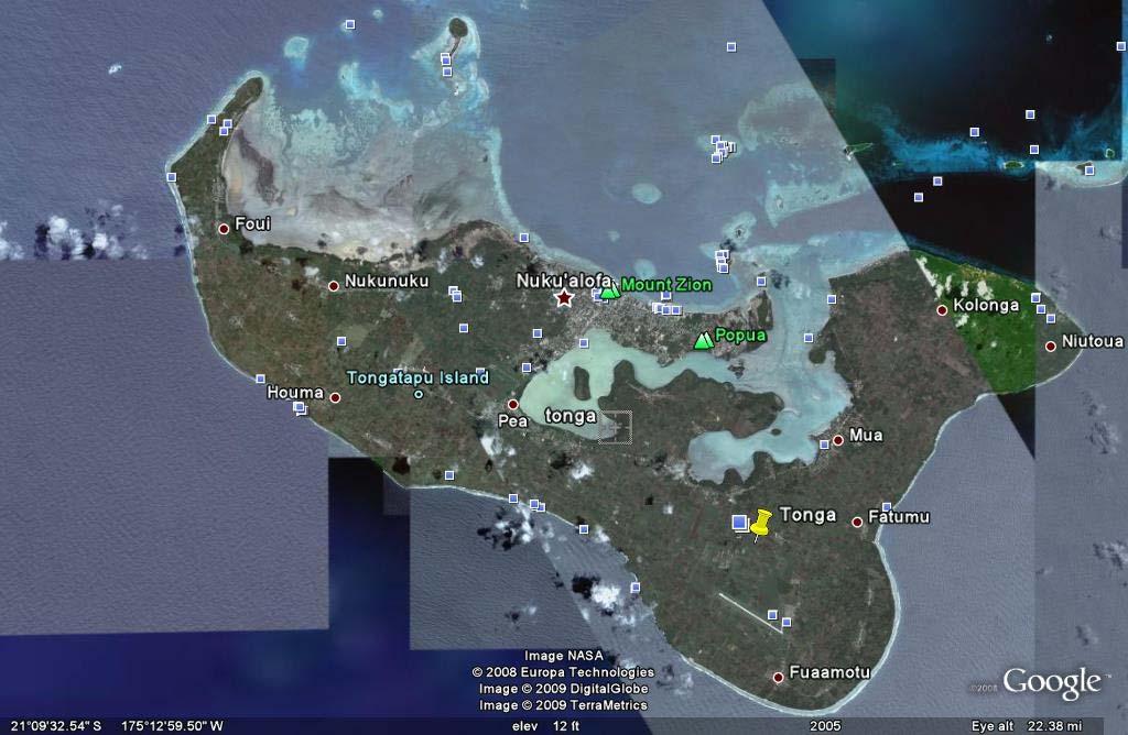
8 Copyright (C) , Microsoft Corporation and its suppliers. All rights reserved. Tongatapu Group Tonga 0 km

9 Neiafu, Vava u Island, Tonga Page 1 Wolfgang Kaehler/Liaison Agency Neiafu, Vava u Island, Tonga Neiafu, the administrative capital of the Vava u Island Group, is one of Tonga s principal ports. Rich, volcanic soils help make agriculture the primary economic activity in the islands, and products include copra, vanilla, and pumpkins. The country s constitution guarantees each male Tongan a plot of ground for farming, although a shortage of land has kept the country from fulfilling this obligation. Microsoft Encarta Encyclopedia Microsoft Corporation. All rights reserved.
10 limate information for Tonga - Climate Zone of 2 1/9/ :36 PM climate ZONE.com United States Alaska Great Plains Hawaii Mid-Atlantic Midwest Northeast Rocky Mountains South Southwest West World Map Continents Africa Asia Australia Europe Middle East North America Oceania South America Countries A-Z ABCDEF G H I J K L M N P R S T U V W Y Z World / Oceania / Tonga Tonga Average temperature, rainfall and snowfall information is available for the following climate stations in Tonga NUKA`ALOFA HA`APAI NIUAFOOU ISLAND Official name: Capital: Area: Climate: Location: Geographic coordinates: Comparative Area: Land boundaries: Coastline: Kingdom of Tonga Nuku'alofa total: 748 sq km water: 30 sq km land: 718 sq km tropical; modified by trade winds; warm season (December to May), cool season (May to December) Oceania, archipelago in the South Pacific Ocean, about two-thirds of the way from Hawaii to New Zealand S, W four times the size of Washington, DC 0 km 419 km Tonga Flight Deals Super cheap tickets - lowest fares! Search all major sites in one place Tonga Real Estate Offers property & business for sale Islands, waterfront, beach land. Tonga Get the Scoop from Travelers Who Know Tonga! Naisoso Island Fiji Luxury freehold waterfront Fijian land for sale from NZ$588, Weather Books Hurricane Books Meteorology Books Tornado Books Weather Books Weather Instruments Hygrometers Outdoor Thermometers Rain Gauges Weather Stations Terrain: Elevation extremes: most islands have limestone base formed from uplifted coral formation; others have limestone overlying volcanic base lowest point: Pacific Ocean 0 m highest point: unnamed location on Kao Island 1,033 m Map of Tonga

11 Climate information for Tonga - Climate Zone 2 of 2 1/9/ :36 PM Portions of this site are based on the CIA World Fact Book, a public-domain work All original material copyright 2004 climate-zone.com. All Rights Reserved. Privacy Policy Contact Us
12 GeoHive 1 of 1 1/9/ :50 PM General info Entity: Tonga Capital: Nuku'alofa Population ( ): 119,009 (CIA) Area: 748 sq.km. Country code: TO Region: Polynesia Tonga Administrative units division island capital area (sq.km.) population census population census 'Eua division Ohonua ,934 5,165 'Eua ,934 5,165 Ha'apai division Pangai ,138 7,572 Foa ,434 1,485 Fonoifua Fotuha'a Ha'afeva Ha'ano Kotu Lifuka (Pangai) ,966 2,968 Lofanga Mango Matuku Mo'unga'one Numuka Nomukeiki 'O'ua Tofua Tungua Uiha Niuas division Hihifo ,018 1,652 Niuafo'ou Niuatoputapu , Tafahi Tongatapu division Nuku'alofa ,979 71,260 Ataa Atataa Eueiki ,877 Fafaa Nukunukumotu Oneata Onevai Pangaimotu Tongatapu , Velitoa Hahake Velitoa Hihifo Vava'u division Neiafu ,715 15,485 Foeata Fofoa 21 Hunga Kapa Kenutu Koloa Lape Nuapapu Ofu Okoa Olo'ua Ovaka Pangaimotu Tapana Taunga Utungake Vaka'eitu Vava'u (Mainland) ,238 12,389 total , ,134 source: Statistics Department, Tonga. note: 2006 numbers are preliminary results. note: The Tongan divisions are actually also divided into districts. CSS XHTML 1.1 GeoHive,
Guam I INTRODUCTION II LAND AND ECONOMY Microsoft Corporation. All rights reserved.
 Page 1 I INTRODUCTION, island in the western North Pacific Ocean, unincorporated territory of the United States, largest and southernmost of the Mariana Islands. It is 48 km (30 mi) long and a maximum
Northern Mariana Islands, Commonwealth
 Northern Mariana Islands, Commonwealth of the Page 1 Northern Mariana Islands, Commonwealth of the Northern Mariana Islands, Commonwealth of the, island group, commonwealth of the United States, in the
TONGA. Stamps of Surcharged 1978 SOUTH PACIFIC GAMES TYPE OLYMPIC GAMES TYPE 15S ON 20S 15S ON 10S ESTABLISHMENT OF CHRISTIANITY TYPE FAO TYPE
 Stamps of 1975-77 Surcharged 1978 SOUTH PACIFIC GAMES TYPE OLYMPIC GAMES TYPE 15S ON 20S 15S ON 10S FAO TYPE ESTABLISHMENT OF CHRISTIANITY TYPE 15S ON 5S 15S ON 5S ESTABLISHMENT OF CHRISTIANITY TYPE SILVER
Unit 11: Tonga: The Koka Tree. Liuaki Fusitu a
 Unit 11: Tonga: The Koka Tree Liuaki Fusitu a Facts Capital Population Highest Point Language Nuku alofa 120, 898 (July 2009 estimate) on Kao Island (1033m) Tongan and English Independence 4 June 1970
Oceania. Australia, New Zealand, and the Pacific Islands. Physical Geography. Where is Australia located?
 Oceania Australia, New Zealand, and the Pacific Islands Physical Geography Australia New Zealand Oceania Where is Australia located? Australia & Oceania are a group of islands located between Asia, Antarctica,
Chapter Objectives. Describe the dominant landforms and natural resources of Southeast Asia. Discuss Southeast Asia s climate and vegetation.
 Chapter Objectives Describe the dominant landforms and natural resources of Southeast Asia. Discuss Southeast Asia s climate and vegetation. The Land Section 1 Objectives Describe how tectonic plates and
Chapter 21: EAST AFRICA
 Chapter 21: EAST AFRICA Physical Geography of East Africa Landforms East Africa is a diverse landscape of different plains, volcanic mountains, and plateaus cut by a large valley and marked by many rivers
Australian Geography. Standards:
 Australian Geography Standards: SS6G12 The student will be able to locate selected features of Australia. a. Locate on a world and regional political-physical map: the Great Barrier Reef, Coral Sea, Ayers
COUNTRY DATA: Costa Rica : Information from the CIA World Factbook! INTRODUCTION GEOGRAPHY
 ! COUNTRY DATA: Costa Rica : Information from the CIA World Factbook! INTRODUCTION GEOGRAPHY Location Area Central America, bordering both the Caribbean Sea and the North Pacific Ocean, between Nicaragua
ISRAEL- COUNTRY FACTS
 ISRAEL- COUNTRY FACTS ISRAEL-NEIGHBOURING COUNTRIES AND POLITICAL MAP Area: 22,072 sq. km Land area: 21,643 sq. km. Fast Facts Area of lakes: 429 sq. km. (Sea of Galilee 164 sq. km., the Dead Sea - 265
Kiribati I INTRODUCTION
 Kiribati Page 1 Kiribati I INTRODUCTION Kiribati, independent republic within the Commonwealth of Nations, located in the central Pacific Ocean, about 4,000 km (about 2,500 mi) southwest of Hawaii. It
Economy 3. This region s economy was based on agriculture. 4. This region produced items such as textiles, iron, and ships in great quantities. For th
 Geography 1. This region has a climate of warm summers and snowy cold winters. 2. This region has a climate that is generally warm and sunny, with long, hot, humid summers, and mild winters, and heavy
Mauritius Official name Population Form of governmen Total area Urban-rural population Head of state Life expectancy Head of government
 Mauritius Official name :Republic of Mauritius Form of government: Republic with one legislative house (National Assembly [691]) Head of state: President Ameenah Gurib-Fakim Head of government :Prime Minister:
Mission Atlas Project. South Georgia and South Sandwich Islands. Country Name: South Georgia and the South Sandwich Islands
 Mission Atlas Project South Georgia and South Sandwich Islands Country Name: South Georgia and the South Sandwich Islands Country Founded in: June 1982 Population: 0, the small military garrison on South
A Country Study of... australia. Sample file. by:
 A Country Study of... australia by: australia FAST FACTS & FIGURES Area Capital Climate Currency Government Language Population m ple Time Zone file Religion Sa OTHER INTERESTING INFORMATION 2011 NotebookingPages.com
Nicaragua versus Costa Rica?
 Nicaragua versus Costa Rica? Overview: Today I want to look at Nicaragua versus Costa Rica from both a destination for retiree s standpoint and for potential investment interest. First I'll provide some
THE USA. The capital of USA is Washington D.C., in the District of Columbia.
 THE USA The United States of America is the richest and one of the biggest countries in the world. It has a population of about 295 million people. It is divided into 50 states; two of them, Alaska and
Welcome to New Zealand Official site for Tourism New Welcome to New Zealand Get official travel information, maps, itineraries, activities
 Welcome to New Zealand Official site for Tourism New Welcome to New Zealand Get official travel information, maps, itineraries, activities accommodation to help you plan your next holiday to New Zealand.
Chapter 20. The Physical Geography of Africa South of the Sahara
 Chapter 20 The Physical Geography of Africa South of the Sahara Chapter Objectives Identify the major landforms, water systems, and natural resources of Africa south of the Sahara. Describe the relationship
The Land Photo Source: The Atlas of Canada, The Red River, Manatoba, Canada land/physio_red_ri
 The Land The United States and Canada An Overview of the Region The United States and Canada are the two largest countries in North America. The Rio Grande is part of the southwest border of the United
Why is the US industry and agriculture prosperous? The US industry and agriculture is so prosperous because it has many different natural resources.
 Ch. 1-7 Study Guide Why is the US industry and agriculture prosperous? The US industry and agriculture is so prosperous because it has many different natural resources. What likely drew immigrants to the
Healing Initiative Leadership Linkage (HILL) Student Magazine: Youth Excellence & Leader: What is catching the attention of your youth?
 Student Magazine: Youth Excellence & Leader: What is catching the attention of your youth?") Healing Initiative Leadership Linkage (HILL) Student Magazine: Country Name Monthly update: Current News Host Editor Country Editor: Insert picture Type the matter. According to illegal Bayrak television,
Healing Initiative Leadership Linkage (HILL) Student Magazine: Country Name Monthly update: Current News Host Editor Country Editor: Insert picture Type the matter. According to illegal Bayrak television,
Location, Climate, & Natural Resources
 Location, Climate, & Natural Resources UK is a country of islands off the coast of mainland Europe. It consists of England, Northern Ireland, Scotland, & Wales. UK s location makes it a HUB for trade.
:: United States Pacific Island Wildlife Refuges Introduction :: United States Pacific Island Wildlife Refuges Background: Baker Island:
 The World Factbook Australia-Oceania :: United States Pacific Island Wildlife Refuges (territories of the US) Introduction :: United States Pacific Island Wildlife Refuges Background: All of the following
The Wonderful Land of Zambia
 The Wonderful Land of Zambia Jessica Geography Have you ever wondered about Zambia's geography? If so, I'm here to tell you! Their climate is very tropical being between 50-80 every day. But it is also
LOCATION, CLIMATE, AND NATURAL RESOURCES OF MEXICO
 SS6G3 The student will explain the impact of location, climate, distribution of natural resources, and population distribution on Latin America and the Caribbean. a. Compare how the location, climate,
Location, Climate, & Natural Resources Brain Wrinkles
 Location, Climate, & Natural Resources Standards SS6G10 The student will explain the impact of location, climate, natural resources, and population distribution on Europe. a. Compare how the location,
Kenya's national Flag
 Kenya Tyler Beck Kenya's national Flag Ethnicity There are many ethnic groups that are a part of Kenya. Kenya has a great European community and a lot of tourists and employees for mission and aid groups,
PORTS PRODUCTIVITY & ITS CHALLENGES. To Regular members of Pacific Maritime Transport Alliance, PMTA.
 P.O Box 144, Queen Salote Wharf, Nuku alofa, KINGDOM OF TONGA. Tel: +676 23168, Fax: +676 24267, Mobile: +676 8452650 Email: pmta.secretariat@portsauthoritytonga.com 43 rd PACIFIC MARITIME TRANSPORT ALLIANCE
CHAPTER 12. South America. Section 1: Natural Environments Section 2: History and Culture Section 3: South America Today. HOLT World Geography
 CHAPTER 12 South America Section 1: Natural Environments Section 2: History and Culture Section 3: South America 1 Section 1 Natural Environments Objectives: What are the major landforms and rivers of
Republic of Botswana. Eva Karasch Lisa Nass
 Republic of Botswana Eva Karasch Lisa Nass Universität Duisburg -Essen Campus Essen WS 2010/11 Modul VI -LN English in Africa Prof. Dr. Raymond Hickey Table of Contents 1. Geography and Demography 2. Politics
!!!!!!!!!!Mali s Geographic Makeup
 DANU Strategic Forecasting Group May 27th 2016!!!!!!!!!!Mali s Geographic Makeup By Liliana Pirlea Location: Mali is a landlocked country located in West Africa. Mali is the 8th largest country in Africa
Human Geography of Canada
 Human Geography of Canada History and Government of Canada Like the United States, people migrated across Beringia into Canada, these people were the ancestors of the Inuit (Eskimos) 16 th and 17 th centuries,
Physical Geography of Europe. Chapters 13-18
 Physical Geography of Europe Chapters 13-18 The British Isles Archipelago made of 6000+ small islands Temperate climate Largest body of fresh water is Loch Ness Mostly rolling hills and large flat lands
Demographic Profile 2013 census
 Demographic Profile 2013 census This profile provides basic population and demographic information on the residents of the Hauraki District. Population and demographic information is important for targeting
QATAR. Its total population is 2,123,160(2014) and it is at number 146 in the world.
 and it is at number 146 in the world.") QATAR Qatar, officially the State of Qatar, is a sovereign Arab country located in Southwest Asia. Its sole land border is with Saudi Arabia to the south with the rest of its territory surrounded by the
QATAR Qatar, officially the State of Qatar, is a sovereign Arab country located in Southwest Asia. Its sole land border is with Saudi Arabia to the south with the rest of its territory surrounded by the
Chapter 24: Southern Africa. Unit 6
 Chapter 24: Southern Africa Unit 6 Section 1: Physical Geography Landforms Region is made up of 14 countries: 1. Angola 2. Zambia 3. Malawi 4. Mozambique 5. Namibia 6. Botswana 7. Zimbabwe 8. South Africa
Republika e Kosovës Republika Kosova-Republic of Kosovo Kuvendi - Skupština - Assembly
 Republika e Kosovës Republika Kosova-Republic of Kosovo Kuvendi - Skupština - Assembly Law No. 03/L-046 LAW ON THE KOSOVO SECURITY FORCE The Assembly of the Republic of Kosovo, On the basis Article 65(1)
Geography. Greece s Physical Geography is: Peninsula (water on three sides) The Peloponnesus. Mountainous Terrain (see Map dark green)
 The Peloponnesus. Mountainous Terrain (see Map dark green)") Grapes Greece Geography Greece s Physical Geography is: Peninsula (water on three sides) The Peloponnesus Mountainous Terrain (see Map dark green) Extends into the Aegean Sea Includes over 2,000 Islands
Grapes Greece Geography Greece s Physical Geography is: Peninsula (water on three sides) The Peloponnesus Mountainous Terrain (see Map dark green) Extends into the Aegean Sea Includes over 2,000 Islands
Seahawk. Charter Itinerary. Fiji, Tonga, Vanuatu, New Caledonia French Polynesia. May / June / July / August
 Seahawk 2017 May / June / July / August Charter Itinerary Fiji, Tonga, Vanuatu, New Caledonia French Polynesia FIJI A country in the South Pacific, is a cluster of more than 300 islands. It's famed for
Montserrat. Country Presentation
 Montserrat Country Presentation Country Background Regional Institution Arrangements Country Sector Characteristics Strengths and weaknesses Opportunities Policy Implication Discovered by Christopher Columbus
UNIT 5 AFRICA PHYSICAL GEOGRAPHY SG 1 - PART II
 UNIT 5 AFRICA PHYSICAL GEOGRAPHY SG 1 - PART II III. CLIMATE & VEGETATION A. The four main climate zones are tropical wet, tropical wet/dry (split into monsoon & savanna), semiarid, and arid. Other climate
Tourism potential in Bangladesh. 26 th of march 2008
 Tourism potential in Bangladesh 26 th of march 2008 Majbritt Thomsen Education In Bangladesh Finding relevant work Danish Embassy B2B DANIDA, production sector Tourism potential report This lecture Share
Albania Official name: Total area Urban-rural population Form of government Urban Rural:
 Albania Official name: Republika e Shqipërisë (Republic of Albania) Form of government: unitary multiparty republic with one legislative house President: Ilir Meta Prime Minister: Edi Rama Capital: Tirana
Read and Respond: Australia
 Read and Respond: Australia Directions: Highlight the answers to the following questions and write them out in complete sentences on your own sheet of paper. GEOGRAPHY OF AUSTRALIA The best way to visualize
A Country Study of... panama. Sample file. by:
 A Country Study of... panama by: panama FAST FACTS & FIGURES Area Capital Climate Currency Government Language Population Religion Time Zone OTHER INTERESTING INFORMATION RECORD NUMBERS The biggest, longest,
CHAPTER IV OVERVIEW. Indonesia. The capital is Dompu. Dompu Regency has an area of 2, km².
 CHAPTER IV OVERVIEW A. General Description of the Research Sites Dompu Regency, is a district in West Nusa Tenggara Province, Indonesia. The capital is Dompu. Dompu Regency has an area of 2,321.55 km².
Chapter 24: Southern Africa. Unit 6
 Chapter 24: Southern Africa Unit 6 Section 1: Physical Geography Landforms Region is made up of 14 countries: 1. 2. Zambia 3. 4. Mozambique 5. 6. Botswana 7. 8. South Africa 9. 10. Swaziland 11. 12. Madagascar
Chapter 14. The Physical Geography of Russia
 Chapter 14 The Physical Geography of Russia Chapter Objectives Identify the physical features and natural resources of Russia. Discuss the effects of Russia s climate and vegetation on life in the region.
FISHERIES (COASTAL COMMUNITIES) (AMENDMENT) REGULATIONS 2016
 (AMENDMENT) REGULATIONS 2016") C T FISHERIES (COASTAL COMMUNITIES) (AMENDMENT) REGULATIONS 2016 Fisheries (Coastal Communities) (Amendment) C T FISHERIES (COASTAL COMMUNITIES) (AMENDMENT) REGULATIONS 2016 Arrangement of Sections Regulation
C T FISHERIES (COASTAL COMMUNITIES) (AMENDMENT) REGULATIONS 2016 Fisheries (Coastal Communities) (Amendment) C T FISHERIES (COASTAL COMMUNITIES) (AMENDMENT) REGULATIONS 2016 Arrangement of Sections Regulation
World History: Patterns of Interaction
 The Americans: A Separate World, 40,000 B.C. A.D. 700 Although early American civilizations remain mysterious, we know that the earliest Americans most likely migrated from Asia and that complex cultures
General Information. Government
 General Information 1. Capital: 2. Official language: le 3. Official name (in French!) 4. National Anthem: 5. Flag: le tricolore (tri-color) 3 vertical sections of,, and 6. National Motto:,, (what does
GEOGRAPHY OF UK. (O Driscoll, James. 2003)
") GEOGRAPHY OF UK (O Driscoll, James. 2003) A group of about 5,000 islands off the northcoast of mainland Europe Between the latitude 50 N and 61 N UK consists of four countries; * England, * Wales, * Scotland,
GEOGRAPHY OF UK (O Driscoll, James. 2003) A group of about 5,000 islands off the northcoast of mainland Europe Between the latitude 50 N and 61 N UK consists of four countries; * England, * Wales, * Scotland,
GEOGRAPHY AND HISTORY
 GEOGRAPHY AND HISTORY YEAR 1, PART 1 www.vicensvives.es Contents 01 Our planet Earth 02 The representation of the Earth: maps 03 The Earth s relief 04 Rivers and seas 05 Weather and climate 06 Climates
PUBLIC OPINION IN KOSOVO BASELINE SURVEY RESULTS NOVEMBER, 2010
 PUBLIC OPINION IN KOSOVO BASELINE SURVEY RESULTS NOVEMBER, 2010 1 METHODOLOGY Quantitative research using face-to-face method within household Sample size n=1500 respondents age 18+ throughout Kosovo Stratified
We live, love and learn together in the light of the life of Christ. 4th May This Week. Year 3 had an amazing time at the Ashmolean Museum.
 We live, love and learn together in the light of the life of Christ. 4th May 2018 This Week Year 3 had an amazing time at the Ashmolean Museum. Catholic Life We celebrated a beautiful Mass for Mary Mother
REPORT PAPER THE MINISTRY OF HIGHER AND SECONDARY SPECIAL EDUCATION TASHKENT INSTITUTE OF TEXTILE AND LIGHT INDUSTRY THE DEPARTMENT: LANGUAGES
 THE MINISTRY OF HIGHER AND SECONDARY SPECIAL EDUCATION TASHKENT INSTITUTE OF TEXTILE AND LIGHT INDUSTRY THE DEPARTMENT: LANGUAGES REPORT PAPER THEME: GREAT BRITAIN DONE BY: THE DEPARTMENT: LANGUAGES TEACHER:
STUDY GUIDE. The Land. Chapter 29, Section 1. Both. Terms to Know DRAWING FROM EXPERIENCE ORGANIZING YOUR THOUGHTS
 Chapter 29, Section 1 For use with textbook pages 719 724. The Land Terms to Know cordilleras Parallel mountain ranges and plateaus (page 719) archipelago A group of islands (page 720) insular Relating
3. British Solomon Islands Protectorate,
 3. British Solomon Islands Protectorate, 1893 1978 During the eighteenth and nineteenth centuries, European colonial powers began to partition the Pacific Islands into settler colonies, Crown colonies
ENGLISH COLONIES CHAPTER 3
 ENGLISH COLONIES CHAPTER 3 NEW ENGLAND COLONIES Colonies MA PLYMOUTH, MA BAY, NH, CT, RI Climate/Geography bitterly cold winters and mild summers; SHORT GROWING SEASONS! Land was flat close to the coastline
The Geological Pacific Northwest. Wednesday February 6, 2012 Pacific Northwest History Mr. Rice
 The Geological Pacific Northwest Wednesday February 6, 2012 Pacific Northwest History Mr. Rice 1 Free Response #2 Please do not simply list the items for this response. Full sentences!!! Minimum of 3-5
Physical characteristics and biomes:
 Physical characteristics and biomes: Sahel region, bordering Sahara Characteristics Area suffers from lack of rainfall, over grazing, which causes loss of vegetation and loss of inhabitable areas causing
INTRODUCTION GEOGRAPHY
 COUNTRY DATA: Cyprus : Information from the CIA World INTRODUCTION A former British colony, Cyprus became independent in 1960 following years of resistance to British rule. Tensions between the Greek Cypriot
Friday, November 10, 2017
 Friday, November 10, 2017 Andes and Midlatitude Countries Objective: Summarize the main physical features and regions of the Southern Cone. Identify and locate the urban centers and understand the pattern
EB5 Visa Green Card... Immigration Through Investment
 EB-5 VISA PROCESS EB5 Visa Green Card... Immigration Through Investment F.A.Q.'s - FREQUENTLY ASKED QUESTIONS What are the benefits of investing in Regional Center projects? Investing in an approved project
Southern Africa. Countries, Geography, & Climate
 Countries, Geography, & Climate The Southern African region consists of the following countries: Angola Zambia Malawi Mozambique Zimbabwe Botswana Namibia Swaziland Lesotho South Africa Comoros Madagascar
Conquered by the Romans in 9 BC. Magyars converted the religion into Christianity in 896 by King Stephen Had the Iron Curtain for 40 years Was a
 Conquered by the Romans in 9 BC. Magyars converted the religion into Christianity in 896 by King Stephen Had the Iron Curtain for 40 years Was a communist country till about 1990. Became member of European
An Exclusive Citizenship by Investment Opportunity
 An Exclusive Citizenship by Investment Opportunity Kimpton Kawana Bay is a 5-star luxury resort development ideally located on world-famous Grand Anse Beach, Grenada Kimpton Hotel & Restaurant Group is
Chapter 4. Daily Focus Skills
 Chapter 4 Daily Focus Skills Chapter 4 On a historical map of the ancient Mediterranean area, locate Greece and trace the boundaries of its influence to 300 BC/BCE. Explain how the geographical location
Mediterranean Europe
 Chapter 17, Section World Geography Chapter 17 Mediterranean Europe Copyright 2003 by Pearson Education, Inc., publishing as Prentice Hall, Upper Saddle River, NJ. All rights reserved. Chapter 17, Section
Case study: outbound tourism from New Zealand
 66 related crime, less concerned about the stability and certainty offered by booking a package holiday, and may choose to be independent travellers, organizing their travel and itinerary themselves. Tourists
STATISTICAL BULLETIN ON INTERNATIONAL ARRIVALS, DEPARTURES AND MIGRATION 2011 SERIES NO. SDT: Government of Tonga
 SERIES NO. SDT: 38-13 Government of Tonga STATISTICAL BULLETIN ON INTERNATIONAL ARRIVALS, DEPARTURES AND MIGRATION 2011 Statistics Department, P.O. Box 149, Nuku alofa, Kingdom of Tonga Website: www.spc.int/prism/tonga/
Tourism Impacts and Second Home Development in Coastal Counties: A Sustainable Approach
 Tourism Impacts and Second Home Development in Coastal Counties: A Sustainable Approach Brunswick, Currituck and Pender Counties, North Carolina (Funded by North Carolina Sea Grant) Center for Sustainable
Capital : Victoria. Weather : Tropical. ~ C Humidity : ~ 80 %. Area earth : 455 sq km. President : Mr. James Alix Michel
 2014 Seychelles's identity card. Nam e :Seychelles. Capital : Victoria. Biggest cities : Anse Royal. Population : 82 247. (2008). Weather : Tropical. ~ 24-31 C Humidity : ~ 80 %. Languages : Creole, French,
Japan is basically a mountainous volcanic Island Chain located in the western Pacific Ocean
 I N T R O D U C T I O N T O J A PA N Japan is basically a mountainous volcanic Island Chain located in the western Pacific Ocean The country has four main Islands HOKKAIDO HONSHU SHIKOKU KYUSHU And then
ALL ABOUT US NEW ZEALAND AUCKLAND
 ALL ABOUT US NEW ZEALAND AUCKLAND About Our School: Kings College Kings College was founded in 1896 and has been providing top class education for over 100 years in Auckland, NZ. There are around 900 pupils
CANADA CARIBBEAN DISASTER RISK MANAGEMENT FUND. Island Snapshot. Trinidad and Tobago
 Island Snapshot Trinidad and Tobago About the CCDRMF The Canada Caribbean Disaster Risk Management Fund (CCDRMF) is one component of Global Affairs Canada s 1 (GAC) larger regional Caribbean Disaster Risk
Mexico. Chapter 10. Chapter 10, Section
 Chapter 10, Section World Geography Chapter 10 Mexico Copyright 2003 by Pearson Education, Inc., publishing as Prentice Hall, Upper Saddle River, NJ. All rights reserved. Chapter 10, Section World Geography
ECONOMIC COMMISSION FOR LATIN AMERICA Office for the Caribbean
 ECLA/POS 75/7 D a t e s 2 M a y 1 9 7 5 ECONOMIC COMMISSION FOR LATIN AMERICA Office for the Caribbean SELECTED INFORMATION ON THE BAHAMAS SELECTED INFORMATION ON THE BAHAMAS The Commonwealth of the Bahamas
Baker Street Elementary & Victorian-ERA.org Presents The Life and Times in Victorian London
 Baker Street Elementary & Victorian-ERA.org Presents The Life and Times in Victorian London Baker Street Elementary & Victorian ERA.org The Life and Times in Victorian London # 200 Victorian Era Timeline
UNIT 3 Extra Review for Chapters 9-11
 UNIT 3 Extra Review for Chapters 9-11 Mexico Central America Caribbean Islands Middle America is Central America, Mexico, and the Islands of the Caribbean Central America is a region within Middle America.
This section of the Plan provides a general overview of the Smoky Mountain Region. It consists of the following four subsections:
 SECTION 3 COMMUNITY PROFILE This section of the Plan provides a general overview of the Smoky Mountain Region. It consists of the following four subsections: 3.1 Geography and the Environment 3.2 Population
Spanish Missions History and Purpose
 Spanish Missions History and Purpose Columbus's voyage of discovery opened a new world of possibilities for the Spanish. In the Americas, Spain soon began to use its soldiers to increase the size of its
THE ALBANIAN NATIONAL MINORITY IN THE REPUBLIC OF SERBIA. Minority Rights Guaranteed by Internal Regulations
 Republic of Serbia MINISTRY OF HUMAN AND MINORITY RIGHTS THE ALBANIAN NATIONAL MINORITY IN THE REPUBLIC OF SERBIA Minority Rights Guaranteed by Internal Regulations Individual and collective rights are
Whale Watching Tourism in the Kingdom of Tonga
 Whale Watching Tourism in the Kingdom of Tonga Preliminary Report for the Pacific Islands Forum October 2007 A report for the International Fund for Animal Welfare and Opérations Cétacés Prepared by: Introduction:
Brazil. Chapter 12. Chapter 12, Section
 Chapter 12, Section World Geography Chapter 12 Brazil Copyright 2003 by Pearson Education, Inc., publishing as Prentice Hall, Upper Saddle River, NJ. All rights reserved. Chapter 12, Section World Geography
SITE SELECTORS INFORMATION
 SITE SELECTORS INFORMATION Location Morden is located in South Central Manitoba, 112 km from Winnipeg City Limits, 19 km from the U.S. border, 127 km from the Winnipeg International Airport. The exact
BRITANNICA STUDENT ENCYCLOPEDIA. Africa is the world s second largest continent. More than 50 countries make up
 JOBNAME: No Job Name PAGE: 33 SESS: 682 OUTPUT: Thu Aug 31 10:43:41 2006 38 Africa BRITANNICA STUDENT ENCYCLOPEDIA Africa Africa is the world s second largest continent. More than 50 countries make up
Warm-up. A. Exports only manufactured goods B. Should import fewer products C. Needs to import more products D. Does not import or export
 Warm-up As with any small country, Cuba has fewer natural resources than countries such as Brazil. This affects their trade in that Cuba A. Exports only manufactured goods B. Should import fewer products
Cuba. Chaudre Rhodes
 Cuba Chaudre Rhodes Economic Beginning in the late 1990s, Cuba experimented with limited market economics, such as pay incentives and bonuses, in an attempt to improve productivity. The government has
394 HAY ST. KALGOORLIE, WA 2x2 VILLAS $305,000
 394 HAY ST. KALGOORLIE, WA 2x2 VILLAS $305,000 THE INVESTMENT OPPORTUNITY YOU HAVE BEEN WAITING FOR SECFI PROPERTY INVESTMENT COACHES Photos taken from actual site. info secfi com au www secfi com au SECFI
SOUTH PACIFIC FORUM Apia, Western Samoa April, 1973 COMMUNIQUÉ
 SOUTH PACIFIC FORUM Apia, Western Samoa 17-18 April, 1973 COMMUNIQUÉ The Fourth South Pacific Forum was opened by the Prime Minister of Western Samoa on 17 April 1973. He welcomed to Apia the President
LATIN AMERICA. Mexico Central America Caribbean Islands South America
 LATIN AMERICA Mexico Central America Caribbean Islands South America HISTORY First Settlers Hunters/gatherers from Asia crossed land bridge connecting Asia and Alaska Learned to farm over time Maize (corn)
KENYA. Soroldoni Simone Luciano Romeo; Mandelli Davide; Rivetti Alessia and Natali Andrea
 KENYA Soroldoni Simone Luciano Romeo; Mandelli Davide; Rivetti Alessia and Natali Andrea HISTORY 2000 BC Cushitic-people 1 century AD 1 millennium Arabs traders, who established Arab and Persian colonies.
Brain Wrinkles. Africa: The impact of location, climate, & physical characteristics on where people live, the type of work they do, & how they travel
 Africa: The impact of location, climate, & physical characteristics on where people live, the type of work they do, & how they travel STANDARDS: SS7G3 The student will explain the impact of location, climate,
area sq. km capital - Camberra situated on the southern hemisphere, surrounded by the Indian and Pacific ocean
 Otázka: Australia and New Zealand Jazyk: Angličtina Přidal(a): Petra The commonwealth of Australia area 7 700 000 sq. km capital - Camberra situated on the southern hemisphere, surrounded by the Indian
Social Studies: The World
 Social Studies: The World What is the name of the continent that is labeled #1 on the map? North America What is the name of the continent that is labeled #2 on the map? South America What is the name
Bosnia and Herzegovina
 UNCTAD Compendium of Investment Laws Bosnia and Herzegovina Law on the Policy of Foreign Direct Investment (1998) Unofficial translation Note The Investment Laws Navigator is based upon sources believed
Latin America 11/4/2013. Latin America Today. 580 million people 9% of the world s population Diverse backgrounds:
 Latin America Chapter 10 Human Geography Latin America Today 580 million people 9% of the world s population Diverse backgrounds: Native Americans Europeans Africans Asians 1 Population 393 million live
CONTENTS SAINT LUCIA AT A G LANCE INVEST IN SM ART M ANUFACTUR ING WHY SAINT LUCIA? OPPORTUNITIES IN SM ART M ANUFAC TU RI N G
 MANUFACTURING IN V ESTME N T O P P O RTUN ITIE S IN SMART MAN UFAC TUR IN G I NVES TM ENT OPPORTU NI TI ES I N S M ART M ANU FACTU RI NG CONTENTS Whether you are a large or small manufacturer, a producer