2. Flood Hazard Assessment
|
|
|
- Lambert Oliver
- 6 years ago
- Views:
Transcription
1 2. Flood Hazard Assessment 2.1 Community Background Incorporated in 1858, the City of Petaluma is situated in southern Sonoma County, in northern California, northwest of San Pablo Bay (Figure 1). San Francisco is 35 miles to the southeast. Petaluma occupies an area of 13.6 square miles along U.S. Highway 101 (City of Petaluma GIS Data, 2010). According to the 2010 census, the current population of Petaluma is 58,401. The Petaluma Valley is a relatively flat alluvial plain developed by overlapping and coalescing alluvial fans derived from the erosion of volcanic rocks in the bordering highlands. This alluvium is comprised of clays, silts, and floodplain sediments, with minor layers of sand and pebble gravels. The elevation ranges from sea level (National Geodetic Vertical Datum of 1929) at the Petaluma River to over 400 ft. in the surrounding hills. The valley enjoys a Mediterranean type of climate, characterized by long, dry summers and cool, wet winters. Temperatures remain moderate throughout the summer and seldom drop below 22 degrees Fahrenheit in the winter. The average annual precipitation over the basin is estimated at 26 inches (City s Consulting Meteorologist, Jim Goodridge). Development in the urban area consists of residential subdivisions, office complexes, small businesses, schools, shopping centers parks and open space. Through the years, growth has resulted in encroachment upon many segments of the waterways in the urban area. A typical waterway courses through a combination of natural and improved sections, with bridges and culverts located at frequent intervals. Buildings and homes have been built along the banks, often limiting the flood-carrying capacity (FEMA, 1989). Petaluma is now in the final stages of a multi-million dollar Flood Control Project undertaken in partnership with the Army Corps of Engineers. Although the project has been marked with delays in funding and cost increases, it is scheduled for completion in summer of 2011, pending congressional funding for the last phase of improvement. The Flood Control Project will be outlined in more detail later in this report. Once completed, it will effectively eliminate the repetitive loss zone within the Payran reach of the City, and will provide 100-year flood protection to this neighborhood. City of Petaluma Floodplain Management Plan 4 October 4, 2010
2 In May of 2008, the City Council adopted a new General Plan. The General Plan contains several policies aimed at improving floodplain management within the City of Petaluma and its watershed. These policies will be described in more detail throughout this FMP. General Plan chapters 4, the Natural Environment, and 8, Water Resources have been included in the FMP appendix A and B. 2.2 History of Flooding In the mid-1800's storm water runoff from the Petaluma watershed, which drained to the Petaluma River and its tributaries, often overtopped the existing channels and spread across the valley until it could return to the waterways and complete its flow to San Pablo Bay. In the ensuing century, with settlement of the town of Petaluma and the surrounding areas, and the urbanization of the region since the 1950's, such overflow could no longer be tolerated. Measures were implemented to improve drainage and control the flooding -- flood control projects were constructed, standards were adopted for private development, and floodplain zoning was instituted. All of these helped to solve many of the problems but, as was most dramatically evident during the storms of January 1982, February 1986 and most recently December 2005, many problems still existed. The most serious of these is the flooding that occurs along the Petaluma River itself. This waterway, which once meandered across the valley, now flows through the most heavily urbanized area of the City of Petaluma and causes significant damage and disruption when storm runoff from its tributary area exceeds its capacity. The largest flood of record in the City of Petaluma occurred during the period of January 3-5, 1982, and caused an estimated 28 million dollars in damages. The flood is documented in an Army Corps of Engineers post-flood report. An excerpt of this report read: "During the January 1982 storm, flooding occurred over a 50+ block area on both sides of the river through the City of Petaluma. Most of the 500 homes and the 100 commercial-industrial establishments in this area incurred flood damage. In many cases, water depth reached two to three feet inside the structure. The most severely hit area appears to be along Jess Avenue where most homes had four to five feet inside. Payran Street was also an area of major damage in which flooding reached over three feet inside the structure." City of Petaluma Floodplain Management Plan 5 October 4, 2010
3
4 Approximately one million dollars in flood damages occurred in the urbanized reach of the Petaluma River between the Lynch Creek confluence and the Lakeville Street Bridge during the flood of February 14-17, On February 15, an article in the San Francisco Chronicle was headlined "Petaluma Takes to the Boats": "Yesterday, most of the townsfolk put their experience to use and took their lumps like troupers. The relatively few newcomers in the hardest-hit Linda Del Mar subdivision, where the water depth in the street reached five feet, "absolutely panicked," according to a veteran of the 1982 deluge." At 4 a.m., a flood alert was posted for the city of 40,000 people. By dawn, a team of police officers, firefighters and volunteers was knocking on doors in Petaluma's flood prone flatlands. About 400 homes were evacuated in the Linda Del Mar subdivision and several trailer parks west and east of U.S.101. Those who could not drive over the flooded roads were removed by bus and, later, by boat. On March 9, 1995, Petaluma once again experienced significant flooding. This flooding resulted in approximately nine thousand dollars of damage to the Petaluma Wastewater Treatment plant when fencing and levees around an aerated lagoon were damaged. There was additional damage to Hopper Street, as well as increased need for electricity usage and monitoring. Seven schools in Petaluma were closed, and a total of 327 homes evacuated, although none were inundated. On March 10, 1995 an article in the San Francisco Chronicle titled Soggy Anger on the Street That Always Floods reads: This same area (Payran Street) has flooded over and over since the big flood of Yesterday was no exception with about 3.5 inches of rain pounding Petaluma during the 24 hours ending at noon. By 7:30 a.m., the raging waters were overflowing the Payran Street Bridge, sweeping over yards, into some garages and basements and forcing emergency workers to order the evacuation of 193 homes of Payran, Jess Avenue and Rocca Drive. Another 134 residences were evacuated at the Leisure Lake Mobile Home Park, where Willow Creek was threatening to overflow its banks and turn the park into an island. By 5 p.m. the waters were dropping, and most residents were allowed to return to their homes. In the winter of the effects of El Nino storms were felt throughout California and the rest of the country. Some large storms hit the West Coast in the first three weeks of February 1998, and these caused flooding in Petaluma as well as in many other parts of the state. The cost of damages in Petaluma was nearly six million dollars. Most of the damage occurred during the flooding on February 2-3, 1998, with some recurring damage City of Petaluma Floodplain Management Plan 7 October 4, 2010
5 from another storm on February 29, State and Federal governments declared the winter storms and flooding a disaster, and FEMA designated the event as FEMA 1203 DR. The greatest damage was to the homes in the Payran area and businesses in the Industrial Avenue/Auto Center Drive area. The oxidation ponds at the City of Petaluma s wastewater treatment facility were damaged once again. Considerable silt buildup in the Turning Basin required dredging, and many roads in the City suffered damages. On February 20, 1998 in an article titled More Rain, More Havoc the San Francisco Chronicle reported: A flash flood caused the Petaluma River to jump its banks and spill into the streets and homes of the hard-hit Payran area of Petaluma. It was the third time in three weeks that the low-lying community has been flooded. Nearly 50 homes were evacuated and cars parked by the river were nearly submerged. Petaluma firefighters used an inflatable boat to rescue a few stragglers. Others waded out of the neighborhood through streets that had as much as three feet of water. Meanwhile, nearly 30 seniors were evacuated from the Leisure Lake mobile home park north of Petaluma when Stony Point Road flooded, cutting off automobile access to the community. Most recently, on December 31, 2005, the City again experienced significant flooding, particularily in the middle and northern areas of town. It is estimated that approximately 53 structures, not including mobile home parks, were damaged by flood waters at an approximate cost of $56,000,000. There was also damage to local streets and river channel banks as a result of the flooding. The greatest damage from this event was located within the Petaluma Factory Outlets, commercial structures and three of the City s mobile home parks. The Payran reach was not adversely affected by this flood, which is mainly attributable to a majority of the Petaluma River Flood Control Project being in place. The flooding event was declared a State and Federal disaster. On December 29, 2006, the Press Democrat published the following excerpt from a year in review article: The New Year's Eve flood was the biggest news story of the year. The flooding - the most severe since caused $56 million in damage, most of it in north Petaluma. In some cases, it took property owners months to recover. Hardest hit were businesses near the Petaluma River, including the auto mall, where hundreds of cars were damaged, and the outlet mall, where 1 to 2 feet of muddy water poured into many shops. City of Petaluma Floodplain Management Plan 8 October 4, 2010
, shown in Figure 2.")
6 (Aerial view of Factory Outlet Mall flooding, 12/31/05) 2.3 Designated Floodplains and Flood Data Approximately 1880 acres of the City of Petaluma lie within the FEMA designated 100- year Special Flood Hazard Area (SFHA), shown in Figure 2. In addition, 112 acres of this area are a designated floodway. In December of 2008, under the map modernization act, FEMA issued updated flood insurance rate maps known as D-FIRMS. The D-FIRMS are very similar to the 1989 FIRM s for Petaluma and are essentially an electronic version of the 1989 FIRM data. The D-FIRMS also include new information that the 1989 maps did not include such as aerial photography. The data is helpful in better determining floodplain locations. The D- FIRMS do not include revised floodplain boundaries based on post 1989 development and structural flood control projects. However, the City of Petaluma is currently in the application process with FEMA staff on the updated watershed wide hydraulic and hydrologic data, which will be used to modify the current D-FIRMS. Based on the remaining flood control project schedule and status of the remapping effort, it is anticipated that new D-FIRMS will be issued by FEMA in less than two years. In addition to the FEMA FIRM maps, the City of Petaluma created and adopted Figure 8.1, 100-year Flood Boundary General Plan 2005 build out. The exhibit with its defined City of Petaluma Floodplain Management Plan 9 October 4, 2010
7 boundary was created to identify limits of the New Year s Eve 2005 flood event and develop policies within the General Plan 2025 that require new development to comply with higher regulatory standards than those defined by FEMA. The limits of this floodplain boundary were determined by a post flood aerial and ground high water mark/debris line survey. Historically, there are two main areas of significant flooding along the Petaluma River. The first area, lying between Denman Flat and the confluence of the Petaluma River with Lynch Creek, consists mainly of commercial, industrial, retail and undeveloped properties. The second area, located between the Lynch Creek/Petaluma River confluence and the Lakeville Street Bridge, consists mainly of residential properties developed during the 1960 s. This residential area is referred to as the Payran reach Floodplain. Significant flooding can occur in the urbanized "Payran Reach" between the Lynch Creek confluence and the Lakeville Street Bridge. However, as of October of 2010, over 90% of the Petaluma River flood control project has been constructed. The project consists primarily of a trapezoidal channel with steel sheet pile walls along the Payran Area of the Petaluma River. The flood control project was designed flood protection in the Payran Area for the 100-year event. The Payran Area did not flood during the December 31, 2005 event. Most of the City has been mapped as AE areas, with determined base flood elevations. There are also two areas mapped as zones AO, which indicates sheet flow on sloping terrain. One area in the City has been classified as Zone AH, which represents an area of ponding. The floodplain area from Denman Flats to Lynch Creek consists of all three of these Zones, while the Payran Area Floodplain is fully zoned AE. The average depth in both Zones AO and AH is one to three feet: 1) AO - East of Rt. 101, bounded by Old Redwood Highway and Corona Creek; 2) AO - Slightly North along US 101 from the Old Redwood Highway intersection; 3) AH Northwest of Capri Creek between US 101 and McDowell Blvd. North. Characteristic floods in the Petaluma River Basin are normally of short duration, lasting a few hours to one or two days. Floods on the Petaluma River may develop within hours after the beginning of a flood-producing storm and begin to recede within hours of the end of the storm. Although floods have been recorded as early as November and as late as April, most occur between December and February after prolonged rainy periods, which fully saturate the soil, increasing runoff volume. Flooding can occur along the entire length of the River. City of Petaluma Floodplain Management Plan 10 October 4, 2010
8 The natural storage area of Denman Flat in the northwestern part of the City, where Willow Brook, Liberty, Marin and Wiggins Creeks come together to form the Petaluma River, acts as a detention basin and helps to reduce downstream peak discharges. Significant flooding occurs in this natural storage area and to the area east of Denman flat between Highway 101 and the Northwestern Pacific railroad line when excess flows in the Willow Brook channel escape as sheet flow to the southwest. Flooding from the Petaluma River can occur in the reach between Denman Flat and the confluence with Lynch Creek, and is generally shallow. Flooding is reduced in depth downstream of Lakeville Street and is fairly well contained in the Petaluma River channel below the "D" Street Bridge. City of Petaluma Floodplain Management Plan 11 October 4, 2010


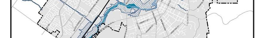

9 Figure 2 City of Petaluma Floodplain Management Plan 12 October 4, 2010
10 2.4 Petaluma Benefit Assessment Zone 2A In 1959, the Petaluma Benefit Assessment Zone 2A was created as a joint flood control endeavor between the City of Petaluma and Sonoma County Water Agency. This zone encompasses 87 square miles bounded by San Antonio Creek on the south; Browns Lane and Stage Gulch Road on the southeast; Railroad Avenue, Roberts Road, and Lichau Road on the North; and Laguna Road, Lake Street and Two Rock Road on the west. In general, the zone includes all tributary drainage reaching the Petaluma River north of the mouth of San Antonio Creek. Residents within this Zone pay an extra tax to fund structural projects that will reduce flooding risks in this area. There is a seven-member Zone 2A Advisory Committee consisting of citizens who reside within the Zone and representatives from the City of Petaluma and Sonoma County. This committee is responsible for recommending budget priorities to the Board of Directors of the SCWA for inclusion in the Zone budget for each fiscal year. 2.5 Petaluma Watershed Master Drainage Plan As a result of the major flooding that occurred in 1982 and 1983, the City of Petaluma requested, and the Flood Control Zone 2A Advisory Committee recommended, that the Sonoma County Water Agency prepare a Drainage Master Plan for the Petaluma River Watershed. The plan was completed in March of Petaluma adopted the Master Drainage Plan as policy under Program 7 of the Community Health and Safety Element of the City s former General Plan ( ), which stated: Program 7 - Adopt the most reasonable, sensitive, and effective proposal(s) of the Sonoma County Water Agency Master Drainage Plan in order to mitigate the 100- year flood. The Master Drainage Plan is used by the Sonoma County Water Agency and the City of Petaluma in their capital improvement planning and construction, and in review and approval of land developments. It provides a valuable tool for consulting engineers by alerting them to the approximate scope of the drainage improvements needed for land development. The Master Plan is used by the Flood Control Zone 2A Advisory Committee to select projects for construction using SCWA funds. On a daily basis, the Master Drainage Plan is used by the SCWA and the City for resource information to respond to questions from the public. The Master Plan has three basic elements. City of Petaluma Floodplain Management Plan 13 October 4, 2010
11 1. The watershed is described as to size, location, land use and other significant information. 2. The flooding and drainage problems of the watershed are described. 3. Structural solutions are described; including anticipated changed conditions or environmental effects. The report includes maps to identify the area studied and also the flood hazard and drainage problem areas; as well as drawings to show the location, size and type of drainage improvements, which, if constructed, would alleviate or eliminate the problem. The Sonoma County Water Agency updated the Petaluma River Watershed Master Drainage Plan in June of The City of Petaluma continues to work with the Sonoma County Water Agency and Zone 2A committee on implementing various projects identified in the master plan. Policy of the City s General Plan 2025 acknowledges the updated master plan and contains policies and programs to work with Sonoma County Water Agency and County of Sonoma staff to implement projects from the 2003 master plan. A copy of the Petaluma River Watershed Master Drainage Plan is available for public review at the City of Petaluma. 2.6 Phase II NPDES Storm Water Management Plan In November of 2003, the City of Petaluma adopted a Storm Water Management Plan (SWMP) per the mandated requirements of the Federal Clean Water Act. The plan identifies the following six minimum control measures that the City must undertake to improve storm water quality: Public Education and Outreach Public Participation and Involvement Illicit Discharge Detection and Elimination Construction Site Storm Water Runoff Control Post-Construction Storm Water Management Pollution Prevention for Municipal Operations The SWMP identifies programs and projects aimed at minimizing accelerated erosion and the amount of sediment laden runoff from entering the Petaluma River. A new storm water ordinance (Chapter of the City s Municipal Code) was adopted as part of the SWMP requirements in June of An update of the SWMP is anticipated in City of Petaluma Floodplain Management Plan 14 October 4, 2010
12 2.7 Seismic and Geologic Hazards Two active faults affect the Petaluma area: the San Andreas Fault and the Healdsburg- Rodgers Creek Fault. Based on a fault evaluation report conducted by the California Division of Mines and Geology, the Tolay Fault zone was removed from the special studies zone designation. Subsequently, the City removed the Hazard Management Zone for the Tolay Fault. Nevertheless, the City s Building Division staff maintains that sitespecific geotechnical field studies should be required for proposed developments on or in the immediate vicinity of the Tolay Fault. City of Petaluma Floodplain Management Plan 15 October 4, 2010
Flood History. Floodplain Descriptions
 Flood History The worst flooding in the area took place in 1966, 1969, 1971, 1995 and 1998. The storms in 1966 and 1969 caused considerable damage throughout the area due to flooding, erosion and debris
II. THE BOULDER CREEK DRAINAGE BASIN
 II. THE BOULDER CREEK DRAINAGE BASIN This section provides an overview of the watersheds and flood hazards associated with Boulder Creek and South Boulder Creek including descriptions of the drainage basins,
Final Drainage Letter Pikes Peak Community College Downtown Parking Lot Colorado Springs, Colorado
 Final Drainage Letter Pikes Peak Community College Downtown Parking Lot Colorado Springs, Colorado Prepared for: Pikes Peak Community College 5775 South Academy Boulevard Colorado Springs, CO 80906-5422
2.0 Physical Characteristics
 _ 2.0 Physical Characteristics 2.1 Existing Land Use for the Project The site is comprised of approximately 114 acres bounded by Highway 101 to the north, the existing town of Los Alamos to the east, State
Mark West Creek Flow Study Report
 Mark West Creek Flow Study Report Biology and Geology of Mark West Creek The headwaters of Mark West Creek are located in the Mayacamas Mountain range, which border Napa and Sonoma County, where it then
Agenda Report. Spruce Street Outlet Drainage Improvements Tower Road Relief Sewer
 Agenda Report Subject: Prepared By: Spruce Street Outlet Drainage Improvements Tower Road Relief Sewer Steven M. Saunders, Director of Public Works/Village Engineer Date: August 12, 2012 On March 8, 2012
Town of Oakfield Agricultural and Farmland Protection Plan
 SECTION III COMMUNITY OVERVIEW A. Regional Setting / Location The Town of Oakfield is located in the northwestern portion of Genesee County. Located west of New York's Finger Lakes, the Town is uniquely
The north half of Section 18, Township 37 North, Range 6 East, Second Principal Meridian, Jefferson Township, Elkhart County, Indiana; also,
 The north half of Section 18, Township 37 North, Range 6 East, Second Principal Meridian, Jefferson Township, Elkhart County, Indiana; also, The east half of Sections 21, 28, and 33, Township 37 North,
SECTION 3 GENERAL DESCRIPTION OF THE RIVER BASIN
 SECTION 3 GENERAL DESCRIPTION OF THE RIVER BASIN SECTION 3 GENERAL DESCRIPTION OF THE RIVER BASIN River basin description. A general description of the river basin or subbasin, as appropriate, in which
DRAFT GENERAL IMPLEMENTATION PLAN AND SPECIFIC IMPLEMENTATION PLAN MIDDLETON MUNICIPAL AIRPORT MOREY FIELD. Revised 12/12/03
 DRAFT GENERAL IMPLEMENTATION PLAN AND SPECIFIC IMPLEMENTATION PLAN MIDDLETON MUNICIPAL AIRPORT MOREY FIELD Revised 12/12/03 As recommended for approval by the Plan Commission General Project Description
CITY OF LYNDEN STORMWATER MANAGEMENT PROGRAM REPORT MARCH 1, 2016
 CITY OF LYNDEN STORMWATER MANAGEMENT PROGRAM 2015 WATER QUALITY MONITORING REPORT CITY OF LYNDEN 300 4 TH STREET LYNDEN, WASHINGTON 98264 PHONE (360) 354-3446 MARCH 1, 2016 This document serves as an attachment
Preliminary Site Evaluation
 Preliminary Site Evaluation 100 Acre Site, US 72 Piperton, Tennessee Power Distributor: Chickasaw Electric Cooperative August 2010 SITE DATA SHEET PIPERTON US 72 SITE (100 ACRES): LOCATION & GENERAL DESCRIPTION
RIO VISTA MUNICIPAL AIRPORT
 DRAINAGE TECHNICAL MEMORANDUM RIO VISTA MUNICIPAL AIRPORT RIO VISTA, CALIFORNIA Prepared for: City of Rio Vista 1 Main Street Rio Vista, CA 94571 (707) 374-5337 Prepared by: August 2012 Copyright 2012
Welcome KROSNO CREEK DIVERSION PROJECT CLASS ENVIRONMENTAL ASSESSMENT
 Welcome KROSNO CREEK DIVERSION PROJECT PUBLIC INFORMATION CENTRE # 1 Tonight s Presentation Study Overview Background Existing Conditions Alternative Solutions Preliminary Preferred Solution Next Steps
Bear Creek Habitat Improvement Project
 06/10/10 Bear Creek Habitat Improvement Project El Paso County, Colorado Pike National Forest and Colorado Springs Utilities Owned Land Report prepared by: Eric Billmeyer Executive Director Rocky Mountain
VI. ALTERNATIVES TO THE MASTER PLAN C. RENOVATED EAST BUILDING ALTERNATIVE
 VI. ALTERNATIVES TO THE MASTER PLAN C. RENOVATED EAST BUILDING ALTERNATIVE INTRODUCTION The Renovated East Building Alternative would include the continued use of the renovated West Building and the renovation
Public Notice ISSUED: December 10, 2018 EXPIRES: January 9, 2019
 APPLICANT: REFER TO: St. Louis and Lake Counties Regional Rail Authority 2018-01942-ARC Public Notice ISSUED: December 10, 2018 EXPIRES: January 9, 2019 SECTION:404 - Clean Water Act 1. APPLICATION FOR
at: Accessed May 4, 2011.
 3.11 SAFETY 3.11.1 Background and Methodology As with other forms of transportation, there is risk associated with aviation activities. This section focuses on risk to those on the ground near airports.
2015 City of Tuscaloosa Floodplain Management Plan Tuscaloosa, Alabama
 2015 City of Tuscaloosa Floodplain Management Plan Tuscaloosa, Alabama Prepared under the direction of the City of Tuscaloosa Floodplain Management Planning Committee With the support of the City of Tuscaloosa
EXECUTIVE SUMMARY COMMONWEALTH OF PUERTO RICO FY 2004-FY2009 MAP MODERNIZATION BUSINESS PLAN. Page i
 EXECUTIVE SUMMARY I. Introduction The Commonwealth of Puerto Rico will support the Federal Emergency Management Agency s (FEMA s) Multi-Hazard Flood Map Modernization Program (MHFMMP) by contributing to
Frequently Asked Questions on the Route 29 Solutions Improvements Projects
 Frequently Asked Questions on the Route 29 Solutions Improvements Projects Background What are the Route 29 Solutions improvement projects? These projects include the Route 29/250 Interchange ( Best Buy
Flying Cloud Airport (FCM) Zoning Process: Informing a Mn/DOT Path Forward
 Zoning Process: Informing a Mn/DOT Path Forward") : Informing a Mn/DOT Path Forward A Review of the Flying Cloud Airport (FCM) Joint Airport Zoning Board (JAZB) Process and the Draft Airport Zoning Ordinance B A RPZ RPZ A B C Zone Chad E. Leqve Director
: Informing a Mn/DOT Path Forward A Review of the Flying Cloud Airport (FCM) Joint Airport Zoning Board (JAZB) Process and the Draft Airport Zoning Ordinance B A RPZ RPZ A B C Zone Chad E. Leqve Director
Airport Planning Area
 PLANNING AREA POLICIES l AIRPORT Airport Planning Area LOCATION AND CONTEXT The Airport Planning Area ( Airport area ) is a key part of Boise s economy and transportation network; it features a multi-purpose
4/28/17. Clicker Question. Clicker Question. #37 Floods IV (Case Histories-Mississippi River Flood, 1993; Red River of North Flood, 1997)
") GEOL 118 Final Exam Format similar to exams 1 and 2 Covers Lectures #27 40 (Global Climate Change I - Meteorite Impacts III) Web Exercise #6 - Due by 1 pm, Monday (5/1) 8:00 AM, Thursday, May 11 th Location
GEOL 118 Final Exam Format similar to exams 1 and 2 Covers Lectures #27 40 (Global Climate Change I - Meteorite Impacts III) Web Exercise #6 - Due by 1 pm, Monday (5/1) 8:00 AM, Thursday, May 11 th Location
City of Fort Lauderdale. Frequently Asked Questions. Proposed Sea Wall Ordinance
 City of Fort Lauderdale Frequently Asked Questions Proposed Sea Wall Ordinance The City of Fort Lauderdale is considering amending the Unified Land Development Regulations of the City of Fort Lauderdale
Introduction. The System. Model Limitations, Assumptions, and Parameters. Optional Services Tech Memo
 Optional Services Tech Memo Introduction This technical memo evaluates the impact of a tide gate to be installed at the confluence of the Left Bank Tributary of Thalia Creek and Lake Windsor. Specifically,
Common Ground Drainage Channel Diversion. Design Report
 Common Ground Drainage Channel Diversion Design Report Resource Management International Inc Consulting Engineers May 2017 COMMON GROUND DRAINAGE CHANNEL DIVERSION PREPARED FOR: QUILL LAKES WATERSHED NO.
Appendix A Appendix A (Project Specifications) Auk Auk / Black Diamond (Trail 44) Reroute
 Auk Auk / Black Diamond (Trail 44) Reroute") Appendix A (Project Specifications) Auk Auk / Black Diamond (Trail 44) Reroute I. Proposed Action: This project proposes to reroute approximately 1,800 feet of a 50 inch wide trail, off of private property
Appendix A (Project Specifications) Auk Auk / Black Diamond (Trail 44) Reroute I. Proposed Action: This project proposes to reroute approximately 1,800 feet of a 50 inch wide trail, off of private property
Triangle Land Conservancy Conservation Area Monitoring Report Carolina North
 Triangle Land Conservancy Conservation Area Monitoring Report Carolina North Property Name: Bolin Creek West Conservation Area Date of visit: March 16, 2017 County: Orange Property Type: Restrictive Covenants
TRINITY RIVER CORRIDOR
 TRINITY RIVER CORRIDOR MODIFIED DALLAS FLOODWAY PROJECT UPDATE May 12, 2015 Jon Loxley Project Manager Dallas Floodway Project Fort Worth District U.S. Army Corps of Engineers US Army Corps of Engineers
CHAPTER III: TRAIL DESIGN STANDARDS, SPECIFICATIONS & PERMITS
 CHAPTER III Trail Design Standards, Specifications & Permits This chapter discusses trail standards, preferred surface types for different activities, permits, and other requirements one must consider
MORGAN CREEK GREENWAY Final Report APPENDICES
 APPENDICES MORGAN CREEK GREENWAY Appendix A Photos of Existing Conditions in Trail Corridor Photos of existing conditions Main trail corridor - February 2009 Photos of existing conditions south bank Morgan
Appendix N MAINTENANCE DREDGING STATEMENT OF NEED & PERMIT COMPLIANCE. North Thousand Islands Management Plan Appendices
 Appendix N MAINTENANCE DREDGING STATEMENT OF NEED & PERMIT COMPLIANCE North Thousand Islands Management Plan Appendices Maintenance Dredging Statement of Need & Permit Compliance The waterways, which consist
Striving for resilience in the face of climate change
 Striving for resilience in the face of climate change Three years and eight months have elapsed since the country suffered one of its worst flooding events, affecting a couple of districts mainly in east-south
SUTTER COUNTY. General Plan Update Technical Background Report
 SUTTER COUNTY General Plan Update Technical Background Report February 2008 SUTTER COUNTY GENERAL PLAN UPDATE TECHNICAL BACKGROUND REPORT PREPARED FOR: SUTTER COUNTY PREPARED BY: PBS&J IN PARTNERSHIP
Hydraulic Report. Trail 5 Snowmobile Trail Over Mulligan Creek. Prepared By: COLEMAN ENGINEERING COMPANY Karisa V. Falls, P.E.
 Prepared for: Prepared by: Marquette County Road Commission Coleman Engineering Company Marquette, Michigan Iron Mountain, MI December 2011 Hydraulic Report Trail 5 Snowmobile Trail Over Mulligan Creek
4. Hydrology of the Olentangy River Watershed
 4. Hydrology of the Olentangy River Watershed The Hydrologic Cycle Water on Planet Earth is dynamic constantly being recycled from the land to the atmosphere to the ocean. Rivers and streams are just a
SUMMER VILLAGE OF SILVER SANDS. Municipal Development Plan
 SUMMER VILLAGE OF SILVER SANDS Municipal Development Plan Bylaw 253-2014 Adopted August 22, 2014 Summer Village of Silver Sands Municipal Development Plan Bylaw No. 253-2014 Page 2 1 INTRODUCTION 1.1 SETTING
The Problem.. SuDS: Controlling the Flow. LANDF RM Technical delivery of SuDS 15/10/2013. Bridget Woods Ballard HR Wallingford 1.
 SuDS: Controlling the Flow 15th October 2013 Bridget Woods Ballard The Problem.. Page 2 Bridget Woods Ballard HR Wallingford 1 15th October 2013 Landform Event Page 3 HR Wallingford 2013 The Aim of SuDS.
CHAPTER 4 -- THE LAND USE PLAN: DESCRIPTIONS AND POLICIES FOR THIRTEEN PLANNING AREAS
 CHAPTER 4 -- THE LAND USE PLAN: DESCRIPTIONS AND POLICIES FOR THIRTEEN PLANNING AREAS NORTH CENTRAL CAC AREA LITTLE VALLEY ROAD TO JUG HANDLE CREEK PLANNING AREA This planning area includes Cleone, Noyo,
Chapter 2: El Dorado County Characteristics and Demographics
 Chapter 2: El Dorado County Characteristics and Demographics 2.1 Geographic Area and Demographics El Dorado County comprises 1,805 square miles with over half of the area in the Eldorado National Forest
Chapter 4.0 Alternatives Analysis
 Chapter 4.0 Alternatives Analysis Chapter 1 accumulated the baseline of existing airport data, Chapter 2 presented the outlook for the future in terms of operational activity, Chapter 3 defined the facilities
ROAD AND TRAIL PROJECT APPROVAL
 ROAD AND TRAIL PROJECT APPROVAL www.marincountyparks.org Marin County Parks, 3501 Civic Center Dr, Suite 260, San Rafael, CA 94903 DATE: July 12, 2017 PRESERVE: Gary Giacomini Open Space Preserve PROJECT:
Waukegan & Calumet Rivers. All Hands Meeting
 Waukegan & Calumet Rivers 516(e) Update All Hands Meeting David F. Bucaro, P.E. Chief, Economic Formulation & Analysis Section, Planning Branch May 18 th, 2011 Kensington Court Ann Arbor, MI 1 2 Waukegan
Chuckanut Ridge Fairhaven Highlands EIS Scoping Concerns
 Chuckanut Ridge Fairhaven Highlands EIS Scoping Concerns Coalition of Southside Neighborhoods CSN Comments for Fairhaven Highlands EIS Scope Hearing, Jan 16, 2008 1 Chuckanut Ridge Hilly Terrain: Potential
Lake Wissota Access Locations within the LaFayette Township. By Chad Martin
 Lake Wissota Access Locations within the LaFayette Township By Chad Martin Anson/ Wissota Access Point # 1 Road: 195 th St. Associated Fire Numbers: 13294 Defining Characteristics: Forested from road
12, 14 and 16 York Street - Amendments to Section 16 Agreement and Road Closure Authorization
 REPORT FOR ACTION 12, 14 and 16 York Street - Amendments to Section 16 Agreement and Road Closure Authorization Date: April 27, 2018 To: Toronto and East York Community Council From: Senior Strategic Director,
Natural Factors Affecting the Level of Osoyoos Lake
 Natural Factors Affecting the Level of Osoyoos Lake Background Osoyoos Lake is operated under conditions prescribed by the International Joint Commission (IJC) and Figure 1 shows the ranges within which
Application for Permit to Develop in a Floodplain Area
 Application for Permit to Develop in a Floodplain Area The undersigned hereby makes application for a permit to develop in a designated floodplain area. The work to be performed is described below and
Overview of Highway 37 Project. Napa County Board of Supervisors December 20, 2016
 Overview of Highway 37 Project Napa County Board of Supervisors December 20, 2016 1 Project Location-Caltrans District 4 2 SR 37 Corridor Features 2 to 4 lane 21 mile corridor traversing Solano, Sonoma,
2018 SPRING MELT: FLOOD PREPAREDNESS
 018 SPRING MELT: FLOOD PREPAREDNESS A Regional District of East Kootenay Preparedness Guide Here in the East Kootenay the spring melt is underway. This seasonal preparedness bulletin will help provide
HYDROLOGY OF GLACIAL LAKES, FORT SISSETON AREA
 PROC. S.D. ACAD. SCI., VOL. 77 (1998) 59 HYDROLOGY OF GLACIAL LAKES, FORT SISSETON AREA Perry H. Rahn Department of Geology & Geological Engineering South Dakota School of Mines and Technology Rapid City,
Version Isolated & Non-Waters Only 1 of 3
 APPROVED JURISDICTIONAL DETERMINATION FORM U.S. Army Corps of Engineers SECTION I: BACKGROUND INFORMATION A. REPORT COMPLETION DATE FOR APPROVED JURISDICTIONAL DETERMINATION (JD): July 6, 2010. B. DISTRICT
CHAPTER 6 NOISE EXPOSURE
 CHAPTER 6 NOISE EXPOSURE FAA requires that the NEM submitted for review represent the aircraft noise exposure for the year of submittal (in this case 2008) and for a future year (2013 for OSUA). However,
Colombia (South America) Water use and drainage in Colombia. Case Study: The Stormwater Challenge in Barranquilla. Humberto Avila.
 Water use and drainage in Colombia. Case Study: The Stormwater Challenge in Barranquilla. Humberto Avila.") Colombia (South America) Water use and drainage in Colombia Location: Case Study: The Stormwater Challenge in Barranquilla Source: Wikipedia The University of Alabama February 25, 2008 Population: 45 million
Colombia (South America) Water use and drainage in Colombia Location: Case Study: The Stormwater Challenge in Barranquilla Source: Wikipedia The University of Alabama February 25, 2008 Population: 45 million
Alternative 3 Prohibit Road Construction, Reconstruction, and Timber Harvest Except for Stewardship Purposes B Within Inventoried Roadless Areas
 Roadless Area Conservation FEIS Summary Table S-1. Comparison of Key Characteristics and Effects by Prohibition Alternative. The effects summarized in this table A would occur in inventoried roadless areas
Final Environmental Impact Statement for the Merced Wild and Scenic River. Comprehensive Management Plan, Yosemite National Park, Madera and Mariposa
 This document is scheduled to be published in the Federal Register on 02/26/2014 and available online at http://federalregister.gov/a/2014-04061, and on FDsys.gov DEPARTMENT OF THE INTERIOR 4312-FF NATIONAL
Public Works Research Institute
 Public Works Research Institute INTERNATIONAL WORKSHOP ON WATER HAZARD AND RISK MANAGEMENT SOME EXPERIENCES OF FLOOD MANAGEMENT IN ARGENTINA VÍCTOR POCHAT National Director for Water Policies,Coordination
Case Study: 1. The Clarence River Catchment
 Case Study: 1. The Clarence River Catchment The NSW coastline is a great natural asset, making an enormous contribution to the economy. The resources of coastal catchments such as the Clarence River Catchment,
Figure 1 shows the evaluation area around Tailings Basin Cells 2E/1E. Two areas were evaluated for potential wetland impacts including:
 Barr Engineering Company 4700 West 77th Street Minneapolis, MN 55435-4803 Phone: 952-832-2600 Fax: 952-832-2601 www.barr.com An EEO Employer Minneapolis, MN Hibbing, MN Duluth, MN Ann Arbor, MI Jefferson
CHAPTER 4 -- THE LAND USE PLAN: DESCRIPTIONS AND POLICIES FOR THIRTEEN PLANNING AREAS
 CHAPTER 4 -- THE LAND USE PLAN: DESCRIPTIONS AND POLICIES FOR THIRTEEN PLANNING AREAS NORTH CENTRAL CAC PLANNING AREA 4.4 FORT BRAGG CITY LIMIT TO HARE CREEK PLANNING AREA (Includes Noyo) The Noyo community
Bradley Brook Relocation Project. Scoping Notice. Saco Ranger District. United States Department of Agriculture Forest Service
 Bradley Brook Relocation Project United States Department of Agriculture Forest Service Scoping Notice White Mountain National Forest February 2011 For Information Contact: Jenny Burnett White Mountain
Chapter 2: Summary of Existing Open Space System
 Chapter 2: Summary of Existing Open Space System In 1976, the Wake County Board of Commissioners established the Wake County Parks and Recreation Department in order to provide park facilities and programs
International Osoyoos Lake Board of Control Annual Report to the International Joint Commission
 International Osoyoos Lake Board of Control 2010 Annual Report to the International Joint Commission TABLE OF CONTENTS ACTIVITIES OF THE BOARD... 1 HYDROLOGIC CONDITIONS IN 2010... 2 Drought Criteria...
CHAPTER 1 INTRODUCTION MORENO VALLEY GENERAL PLAN 1. INTRODUCTION. 1.1 What is a General Plan?
 1. INTRODUCTION 1.1 What is a General Plan? A General Plan is a comprehensive long-term strategy for the physical development of a city. It determines how land may be used and the infrastructure and public
MEETING OF THE METROPOLITAN PARKS AND OPEN SPACE COMMISSION Tuesday, April 4, 2017
 Minutes of the MEETING OF THE METROPOLITAN PARKS AND OPEN SPACE COMMISSION Tuesday, April 4, 2017 Committee Members Present: Tony Yarusso, Rick Theisen, Robert Moeller, Todd Kemery, Sarah Hietpas, Margie
Hydro-Electric Schemes Compliance Report June June 2013
 File Reference: 4.00212 Significance of Decision: Receives Only - No Decisions Report To: Operations, Monitoring and Regulation Committee Meeting Date: 20 June 2013 Report From: Nick Zaman, Pollution Prevention
GILBERT & WEST TOWN INTERCOUNTY DRAIN Windsor Township, Eaton County and City of Lansing, Delhi Township, Ingham County, Michigan
 GILBERT & WEST TOWN INTERCOUNTY DRAIN Windsor Township, Eaton County and City of Lansing, Delhi Township, Ingham County, Michigan PRELIMINARY ENGINEERING REPORT Abigail Eaton, Chair Intercounty Drains
Mr. Michael Malone CPS Energy 145 Navarro Street San Antonio, Texas Project No
 January 15, 2016 Mr. Michael Malone 145 Navarro Street San Antonio, Texas 78205 Project No. 0328985 Environmental Resources Management CityCentre Four 840 West Sam Houston Pkwy N. Suite 600 Houston, Texas
The Evolution of DFW Airport s Deicing Program Balancing Risks with Results MAY 20, 2015
 Dallas/Fort Worth International Airport The Evolution of DFW Airport s Deicing Program Balancing Risks with Results MAY 20, 2015 DFW: Connecting The World The cities of Dallas and Fort Worth overcame politics
PLANNING CONSIDERATIONS
 12TH NOGALES PARK TUCSON ALVERNON SWAN WILMOT CAMPBELL DREXEL COUNTRY CLUB LEGEND RESERVE LAND AREA (APPROXIMATE) POTENTIAL FUTURE HSR TO AIRPORT TRANSIT CONNECTIONS VALENCIA PIMA COUNTY CITY OF TUCSON
CITY COUNCIL AGENDA MEMORANDUM
 To: Mayor and City Council From: Charles Ozaki, City and County Manager Prepared By: Kevin Standbridge, Deputy City and County Manager Katie Allen, City and County Engineer David Shinneman, Community Development
COASTAL CONSERVANCY. Staff Recommendation September 22, 2011 BAY AREA RIDGE TRAIL: HOOD MOUNTAIN TO HIGHWAY 12
 COASTAL CONSERVANCY Staff Recommendation September 22, 2011 BAY AREA RIDGE TRAIL: HOOD MOUNTAIN TO HIGHWAY 12 File No. 11-039-001 Project Manager: Betsy Wilson RECOMMENDED ACTION: Authorization to disburse
The Geological Pacific Northwest. Wednesday February 6, 2012 Pacific Northwest History Mr. Rice
 The Geological Pacific Northwest Wednesday February 6, 2012 Pacific Northwest History Mr. Rice 1 Free Response #2 Please do not simply list the items for this response. Full sentences!!! Minimum of 3-5
City of Peoria Clean Water Efforts. Governor s s Conference on the Management of the Illinois River October 4, 2007
 City of Peoria Clean Water Efforts Governor s s Conference on the Management of the Illinois River October 4, 2007 1 What do you call dinner and a movie with an unemployed guy? An unfunded man-date! 2
Business Item No XXX. Proposed Action That the Metropolitan Council approve the Coon Creek Regional Trail Master Plan.
 Business Item No. 2015-XXX Metropolitan Parks and Open Space Commission Meeting date: July 7, 2015 For the Community Development Committee meeting of July 20, 2015 For the Metropolitan Council meeting
Northeast Quadrant Distinctive Features
 NORTHEAST QUADRANT Northeast Quadrant Distinctive Features LAND USE The Northeast Quadrant includes all the area within the planning area that is east of Interstate 5 and to the north of State Route 44.
Mt. Hood National Forest
 United States Department of Agriculture Forest Service Mt. Hood National Forest Zigzag Ranger District 70220 E. Highway 26 Zigzag, OR 97049 503-622-3191 Fax: 503-622-5622 File Code: 1950-1 Date: June 29,
Paul Sturm Roberto Viqueira Ríos
 Paul Sturm Roberto Viqueira Ríos In this talk Brief Background on Land Based Sources Historical Perspective Guánica watershed characteristics/ issues High priority restoration projects Other key issues
Understanding user expectations And planning for long term sustainability 1
 Understanding user expectations And planning for long term sustainability 1 What is a natural surface trail? It can be as simple has a mineral soil, mulched or graveled pathway, or as developed as elevated
Parkland County Municipal Development Plan Amendment Acheson Industrial Area Structure Plan
 Parkland County Municipal Development Plan Amendment Acheson Industrial Area Structure Plan New Plan Acheson Industrial Area Structure Plan Amendment Parkland County Municipal Development Plan Board Reference
HILLSBOROUGH COUNTY, FLORIDA AND INCORPORATED AREAS
 VOLUME 2 OF 5 HILLSBOROUGH COUNTY, FLORIDA AND INCORPORATED AREAS Hillsborough County COMMUNITY NAME COMMUNITY NUMBER HILLSBOROUGH COUNTY (UNINCORPORATED AREAS) 120112 PLANT CITY, CITY OF 120113 TAMPA,
ATTACHMENT B. Reference No.
 ATTACHMENT B Projects in the Five-Year Capital Improvement Program for Fiscal Years Ending 2014-2018 GOVERNMENT CODE SECTION 65402 GENERAL PLAN CONFORMITY ANALYSIS 1 4 Orcutt GS Station 21 (Orcutt) Rebuild
LITTLE LOST MAN CREEK (LLM) (formerly USGS Gaging Station No )
 (formerly USGS Gaging Station No )") LITTLE LOST MAN CREEK (LLM) (formerly USGS Gaging Station No. 11482468) LOCATION: In Redwood National and State Park approximately 0.8 miles upstream from confluence with Prairie Creek and 3.2 miles northeast
LITTLE LOST MAN CREEK (LLM) (formerly USGS Gaging Station No. 11482468) LOCATION: In Redwood National and State Park approximately 0.8 miles upstream from confluence with Prairie Creek and 3.2 miles northeast
Presented to: City of Petaluma City Council
 Agenda Item #1.A REVISED Presented to: City of Petaluma City Council Presented By: Dan St. John, F.ASCE, Director Jason Beatty, P.E., Senior Engineer James 'Jody' Boyette, USACE Project Manager November
ES Aircraft Deicing Document Identification Number Date: March 15, ) Activity Description:
 Activity Description:") ES-301-1.06 Aircraft Deicing Document Identification Number ES-301-1.06 Date: March 15, 2018 Document Owner: Keith Pass 1) Activity Description: Aircraft deicing is the application of aircraft deicing
ES-301-1.06 Aircraft Deicing Document Identification Number ES-301-1.06 Date: March 15, 2018 Document Owner: Keith Pass 1) Activity Description: Aircraft deicing is the application of aircraft deicing
Region 1 Piney Woods
 Region 1 Piney Woods Piney Woods 1. This ecoregion is found in East Texas. 2. Climate: average annual rainfall of 36 to 50 inches is fairly uniformly distributed throughout the year, and humidity and temperatures
47I THE LAS ANIMAS GLACIER.
 THE LAS ANIMAS GLACIER. ONE of the largest of the extinct glaciers of the Rocky Mountains was that which occupied the valley of the Las Animas river. This stream originates in the San Juan mountains in
The Galveston Seawall
 Coastal and Ocean Engineering ENGI.8751 Undergraduate Student Forum Faculty of Engineering and Applied Science, Memorial University, St. John s, NL, Canada. March, 2013 The Galveston Seawall Mark Harvey
Decision Memo Ice Age Trail Improvement (CRAC 37)
") Decision Memo Ice Age Trail Improvement (CRAC 37) U.S. Forest Service Chequamegon-Nicolet National Forest, Medford-Park Falls Ranger District Taylor County, Wisconsin T32N, R2W, Town of Grover, Section
Decision Memo Ice Age Trail Improvement (CRAC 37) U.S. Forest Service Chequamegon-Nicolet National Forest, Medford-Park Falls Ranger District Taylor County, Wisconsin T32N, R2W, Town of Grover, Section
Overview of Highway 37 Project. Novato Rotary November 4, 2016
 Overview of Highway 37 Project Novato Rotary November 4, 2016 Project Location-Caltrans District 4 SR 37 Corridor Features Two to Four lane 21 mile corridor traversing Solano, Sonoma, and Marin Counties.
ALPINE PIPELINE RIVER CROSSINGS 2009 MONITORING REPORT
 ALPINE PIPELINE RIVER CROSSINGS 2009 MONITORING REPORT Submitted to ConocoPhillips Alaska, Inc. Submitted by Michael Baker, Jr., Inc. 1400 West Benson Blvd., Suite 200 Anchorage, Alaska 99503 TABLE OF
Friday, November 10, 2017
 Friday, November 10, 2017 Andes and Midlatitude Countries Objective: Summarize the main physical features and regions of the Southern Cone. Identify and locate the urban centers and understand the pattern
Brevard County Utility Services Department
 Brevard County Utility Services Department April 3, 2018 Jim Helmer, Department Director Brian Sorensen, W/WW Manager 1 Utility Services Department 9 TREATMENT PLANTS 6 WASTEWATER, 3 WATER 163 EMPLOYEES
Northern Rail Extension, Phase One
 General Project and Funding 1. Where does Phase One start? The rail line for Phase One begins roughly at the northern boundary of the former Bradbury property, but also includes work along Tom Bear Trail
Energy from Waste and Recycling Facility Trident Park, Cardiff. Planning History. January 2010 SLR Ref: B
 Energy from Waste and Recycling Facility Trident Park, Cardiff Planning History January 2010 Ref: 402-0036-0306B Viridor Ltd. i 402/0036/00306B CONTENTS 1.0 INTRODUCTION... 1 2.0 GENERAL HISTORY... 3
City of Doral Flood Warning and Response Plan
 City of Doral Flood Warning and Response Plan Prepared by: City of Doral Public Works Department Stormwater Division City of Doral Flood Warning and Response Plan Flood events tend to pose a variety of
ALTA/ACSM LAND TITLE SURVEY Parts of Augusta Heights, First Section (Plat Book 20, Page 5), Augusta Heights, Second Section (Plat Book 19, Page 25),
, Augusta Heights, Second Section (Plat Book 19, Page 25),") ALTA/ACSM LAND TITLE SURVEY Parts of Augusta Heights, First Section (Plat Book 20, Page 5), Augusta Heights, Second Section (Plat Book 19, Page 25), and Augusta Park, 3rd Section (Plat Book 24, Page 132)
ALTA/ACSM LAND TITLE SURVEY Parts of Augusta Heights, First Section (Plat Book 20, Page 5), Augusta Heights, Second Section (Plat Book 19, Page 25), and Augusta Park, 3rd Section (Plat Book 24, Page 132)
COASTAL CONSERVANCY. Staff Recommendation December 2, 2004 COYOTE HELLYER COUNTY PARK BAY AREA RIDGE TRAIL
 COASTAL CONSERVANCY Staff Recommendation December 2, 2004 COYOTE HELLYER COUNTY PARK BAY AREA RIDGE TRAIL File No. 04-057 Project Manager: Amy Hutzel RECOMMENDED ACTION: Authorization to disburse up to
Appendix 4 St. Charles Basin
 Appendix 4 St. Charles Basin The St. Charles hurricane protection system (HPS), shown in Figure 1, was designed as part of the Lake Pontchartrain, LA, and Vicinity Hurricane Protection Project. The St.